The Maps
Here is a selection of some of our favorite maps. Some of the files here are large and might take a moment to load. The neighborhood plats are organized alphabetically. At the bottom of the plats you’ll find several city-wide maps we think you’ll find of interest. A great source for Portland-wide historic maps is the City of Portland Archives site. Neighborhood plat maps can also be found on the Multnomah County Surveyor’s SAIL website (it’s a great site loaded with information, but takes some trial-and-error to learn how it works).
Welcoming additions to this collection or maps you’d like to see here.
Alameda Park 1909

Click on the map for a larger image, or to download a copy.
This early plat map was created in 1910 by the Alameda Land Company and used in its original marketing materials. This plat shows the Alameda Park Addition, but clearly misses big chunks of today’s Alameda, which were added in the teens and twenties through new plats known as Pearson’s Addition, the Fremont Addition, Olmstead Park, Irvindale, Dunsmeade and the Miami Addition.
By 1915, at least 900 plats had been filed in Portland, many of which were much smaller than Alameda Park, and all were named by developers searching for an attractive sounding name. While in some areas the plats have retained their distinct personality and name, like Alameda, the identity of many smaller plats in our neighborhood have dissolved into the more commonly used neighborhood name of Alameda. The plat names remain today on title documents and land records for these areas.
You’ll note that many of the lots we know today are shaped differently than in the original plat. But the streets, and the Broadway Streetcar line, are in the right place. This map does not have addresses, but if it did, the addresses would not make much sense to Alamedans today. The entire city was re-addressed in the early 1930s. Click here for an article in the Alameda Stories that sheds light on the “great renumbering” of the 1930s, and the background behind our street names.
Some amazingly detailed fire insurance maps of the neighborhood were drawn up by the Sanborn Company in 1924. Click here for an illustrated article I’ve written about the Sanborn maps and a link to the maps themselves.
Beaumont 1910
Between Fremont and Knott, from 39th to 45th, platted in 1910.
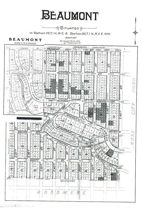
Click on the map for a larger image, or to download a copy.
Elberta Addition 1906
Between Alberta and Prescott, from 28th to 33rd. Platted in 1906.

George Place Addition 1910
A tiny plat that takes in what we might think of today as southwest Alameda Park. It was platted in 1910 by Horace C. and Mary George.

Gile Addition 1921
Albion L. Gile — partner in the Gile Investment Company — and his wife Katherine, financed and platted a 1921 addition on the west side of the neighborhood straddling the ridgeline, near the alley-like street that bears their name today. The Giles were a prominent Astoria family. Most of the houses on this street were built by local builder Harry Phillips, and designed by Portland architect Harry Wolff.

Ina Park Addition 1905

Screenshot
Lester Park Addition 1906
Between Alberta and Prescott, from 25th to 27th. Platted in 1906.

Olmstead Park 1909
Between Shaver and Fremont, from 29th to 33rd. Platted in 1909.
Click on the map for a larger image, or to download a copy.
This 15-block, 290-lot subdivision is north of the Alameda Ridge and tucks in under the southeast corner of Alameda Park. Today this part of the neighborhood is clearly considered part of the Alameda District. Out on the ground even in 1911, these two brand new districts were indistinguishable, interwoven by the same streets, the same water, gas and sewer mains, and many of the same architects and builders who were beginning to populate this area with homes. For more information, see the post about Olmstead Park.
Vernon 1903
Between Killingsworth and Prescott from 15th to 25th. Platted in 1903.

Here’s a “replat” of Vernon, made after the initial filing that shows that portion of Vernon south of Prescott, including the mysterious shrinking Crane Street.

Wilshire 1921
This part of the neighborhood was platted in 1921. This plat of Wilshire is helpful because you can see where all the neighboring other plats connect. If you’re having a look at this one, be sure to read the post about the Prescott Jog.

Click on the map for a larger image, or to download a copy.
Woodstock Amended Plat 1890

Check out this piece about the interesting addressing history in Woodstock.
City of Portland Real Estate Map, 1906

Click on the map for a larger image, or to download a copy.
Alameda does not yet appear on this map. The location of today’s neighborhood is in the southwest quarter of Section 24. Irvington is in place, with NE 24th Avenue as its eastern boundary. There are several nearby subdivisions showing that were never built.
Portland Traction Company Streetcar/Bus Map – 1945
The streetcar system evolved in the first two decades of the 20th Century and peaked in the mid 1920s with routes that covered much of the city and beyond. Here’s the system map from 1945, a time when most of the streetcar routes were on their way out. Look carefully and you can see the distinction between streetcar, trolley and motor coach routes.

For other streetcar routes and information, check out this great website, operated by Portland Vintage Trolleys.
City of Portland Paving Map 1894
Here’s a great map from 1894 showing just how few of Portland’s streets were paved. Many of Northeast Portland’s neighborhoods we know today didn’t yet exist (though some had been platted). Look for the “Portland Speed Association Race Track,” which is today’s Irving Park. The blank spot in Section 24 (northeast of the racetrack) is where today’s Alameda exists. Like the 1906 map, quite a few of the platted subdivisions showing here were never built. Here’s something that will help you orient to the map and to the system of sections, townships and ranges that’s still present today: Killingsworth, Fremont, Broadway and Stark all exist on section lines. See if you can find them!

Pittmon’s 1915 City of Portland Map
Courtesy of City Archives, image A2004-002

1852 Government Land Office Cadastral Map


1897 USGS Quad Map of Portland


Greetings,
You have an interesting site.
Do you know if Alameda was once referred to as ‘Gravel Hill’, or the ‘Highlands’? I looked through several weeks of the Oregonian from 8/2/1898 to 9/8/1898 and read about a fire on, or visible from Gravel Hill, and/ or the Highlands, but no street address.
The article was one short paragraph. It mentioned some names that I didn’t write down and don’t recall. I wondered if the hill or the ‘Highlands’ might be a previous set of names for Alameda because the article said something about Sullivan’s Gulch, either that the fire was extinguished with water from there, or that people took refuge there.
I’ve read that Alameda Hill was formed by gravel left by floods (Bretz?), so I wondered if Alameda might be the Gravel Hill referred to in the article.
Thank you,
Jon Wood
Hi Jon.
Thanks for stopping by for a visit. I am intrigued to know more about the article you read. Did you by chance make a copy or do you have the date and page?
Yes, Gravel Hill was the name of the high point at today’s NE 33rd and Fremont. For many years there was a gravel pit of sorts on the southwest corner of that intersection which was also used as a garbage dump. There would have been a great view from that spot out across the flats below, which were populated by several small farmsteads and orchards.
I’ve not heard of the term “the highlands” in reference to the Alameda ridge, but it could be. The newspaper story might shed light on that: was the view off toward the fire at the highlands? Maybe that refers to the ridgeline we think of today as Forest Park, also called the Tualatin Mountains. Hmm. Check out the article I’ve written about the Pearson Farm, which actually refers to a forest fire just adjacent to Gravel Hill.
Yes, you’re absolutely correct about the geology.
-Doug
Doug, could you shed some light as to why and when the western portion of Alameda Park was separated off and made part of Sabin? The area is west of NE 23rd and north of The Alameda and also South of the Alameda between NE 21st and NE 19th.
Maybe some history of the creation of Sabin?
Thank You, Tony Jenkins
Hi Tony. Thanks for dropping by the blog. I will look into the specifics of Sabin and will post a plat map here in the next few days, but wanted to address your question: Alameda was not platted until 1909 and the earliest construction followed in 1910 and 1911. There are earlier houses (1905-1906) in Sabin. Interesting to note that the Vernon neighborhood, just north of Alameda Park across Prescott, was also platted and built before Alameda. Even though they are not part of the “Alameda Park Addition” proper (they are in “Homedale”), the houses on the west side of NE 21st between Fremont and Alameda were built in the 1920s, at the same time as most of the bungalows on the east side of the street were. Stay tuned, I’ll post the plat map soon.
My house is on the West side of NE 21st near Ridgewood and was built in the “Alameda Park Addition” proper. My deed says so as does the map of the Alameda Park Addition in this blog. Thanks for researching this.
Doug, I have thoroughly enjoyed your website and its links. I grew up at 2415 NE 28th Ave. (near Brazee). I believe our house was built in 1911. My parents moved in in 1952. Us kids were always told the neighborhood was called Dolph Park, but the Portland neighborhoods book doesn’t have that. I know this area is not in Alameda, perhaps Fernwood. Could you point me to a source for learning a little about my old home area? Thanks.
I grew up in Alameda. My address was 4204 N.E.32nd Ave. This house was build in 1912 and had two lots. The original oner was Robert Maguire who was a US attorney at the time. The original address was 900E. 32nd North. I studied the history of the home and know much about this area if you want to know more. Jerrold Lyle
My old house at 2415 NE 28th Ave. (formerly 493 E. 28th St. North) is in the Bowering Tract. While this is a bit southwest of your old house, do you have any knowledge about the Bowering Tract? Thanks.
Hi Bob. Yes, the Bowerings were a family who lived in the area in the mid-19th Century and received a 320-acre grant of land from the US Government, known as a Donation Land Claim, or DLC. William and Isabella Bowering (married in 1833), and eventually their children John and Marietta, sold off portions of the land over the years. Much of today’s Alameda neighborhood was part of the original Bowering Donation Land Claim. After having a look at the the “Bowering DLC Tract” plat, which was filed with the Multnomah County Surveyor in February 1872, it’s interesting to note the Bowerings platted this small piece of their overall claim long before the grid we know today. Their initial plat was for 12 five-acre lots, and two three-and-one-third acre lots. Mini farmsteads. It’s an interesting shaped plat, long and narrow, and served originally by NE 33rd, which was then simply known as a county road. If you look at all the surrounding plats, it’s clear there were a lot of replats made over time. The Bowering Tract remains a touchstone to our past…
I was delighted to discovery your excellent web site while researching street name changes in Portland.
My grandfather’s home was located at 301 Glenn Avenue. Can you help me locate this street number on Alameda Park Avenue map? It appears that the numbering got changed as well as the street names.
R. Goodall
Hi Richard. Thanks for dropping by the blog…glad you enjoyed it.
I’ve examined the early addresses on Glenn and all of the resources I have suggest that the Glenn (now 32nd Place) addresses run from 476 Glenn (now 2316 NE 32nd Place), which is just north of Thompson, to 1150 Glenn (now 5435 NE 32nd Place). Tell me a bit more about where he lived and let’s see if we can sleuth this out.
-Doug
Hi Doug,
You’ve got a great website here. I’m trying to find the original address of 3222 NE 37th – it was built in 1928. One of the Sanborn maps covers 1924-1928, but I’m having trouble locating the area online.
Any help would be much appreciated!
Thanks,
Mike
Hi Mike. Thanks for visiting the website. I’ve sent you a detailed response by e-mail. I know the house and am familiar with several others in that area…
-Doug
The University of Oregon has a research paper in the School of Architecture library on the hill know back in the day as “dirt hill”. I will see if I can find a link online and post it. As a kid I remember playing on the hill before they built the stairs.
SKoch
I’m curious about a block numbering discrepancy. According to Portlandmaps, my house is in Vernon, block 53. But according to the plat map shown here, it is block 51 (I’m basing that on the street name). Does anyone know why that is? Is the Great Renaming/renumbering the reason for the difference?
If anyone is interested, here’s what happened. Vernon was originally platted in 1903, but on October 10, 1907, the City passed Ordinance 17118 that renumbered a bunch of streets across the city. Most of the streets in Vernon were reduced by one number. So if you live on 21st, it was originally 22nd, etc.
The Portland Real Estate Map of 1906 is either no longer available on the Portland Archives, or it is filed under a different name. Can you provide more detailed information on how to find it? Thanks!
Hi Tony, thanks for dropping by the blog. Yes, looks like the city has taken down that link to the higher resolution of that map and I have yet to find a better version of the one here. Just for fun, I did add a map: the 1894 paving map of Portland, which is fascinating. Take a look: https://alamedahistory.files.wordpress.com/2020/11/paving-map-of-portland-january-1-1894.jpg
Hello im wondering what part of portland was once referred to as “windsor heights”
We love questions like this!
Windsor Heights is a small 1909 plat inside today Southeast Portland’s Richmond neighborhood.
The plat exists between SE Division on the north and SE Woodward (known as Ellsworth Street in 1909) on the south, and between SE 47th on the west and the middle of the street of SE 49th on the east (including the west side of 49th between Division and Woodward).
Windsor Heights is relatively small by Portland plat standards: two long blocks north to south, containing about 85 lots. On the west side, it’s adjacent to the plats known as Leland Park and Pecks Addition. Just to the west (outside the plat) is today’s Ivon Street Park.
Platted in April 1909, Windsor Heights was a project of the Tabor Investment Company, which developed the property that was once part of the 323-acre Hampton Kelly Donation Land Claim (the Kelly clan had a huge influence on development of lands in southeast Portland). The lands passed from Hampton Kelly eventually to Jennie A. and William H. Oakes, who sold them to the Tabor Investment Company.
Today’s SE Windsor Court—the only visible clue to the plat—runs east-west one block south of Division between 43rd and 47th, actually outside and just west of the Windsor Heights Plat.
Early advertisements claimed superior views: “The are some view lots in this tract that cannot be surpassed anywhere in Portland.” “The best buy on the eastside.”
Hi Doug
I’ve been spending quite a bit of time reading through your website. I grew up on NE 24th between Hancock and Tillamook through most of the 50’s and 60’s. Never knew until now that 24th was a trolley line. The large house on the NW corner of Tillamook and 24th was, I think, once owned by a governor of Oregon. I was very familiar with Deadman’s Hill when there was enough snow.
The aerial photo of 24th and Fremont got me to wondering if there is one further south on 24th near Broadway? I also cannot nail down which plat we were part of.
Had I lived on the east west side of 24th I would have attended Irvington grade school but instead I had a good walk to Fernwood For a long time I thought we were part of Dolph Park or Glenneryie(sp?) but looking at the maps on this site neither work.
Any directions you might point me would be greatly appreciated.
Thanks
db