First of three parts: Understanding the neighborhood’s early beginnings
We’ve been working on a fascinating property in the Concordia neighborhood, formally known as Lester Park (that’s not a typo, that’s an actual plat name).
It’s a store and home built by Irish immigrants and operated for several generations, eventually running out of retail energy in the 1960s when it became a church and then an artist’s studio before nearly collapsing from years of deferred maintenance and decline. We’re eager to share the fascinating story of this sweet little building—which has been lovingly restored—and an incredible photograph from the pinnacle of its retail life.
But first, we have to provide some context about the area that today might like to be known more for its hipness than the complicated polarity of change underway through gentrification, though both are present.
To be clear, the geography of the area in mind actually holds several of today’s formally named neighborhood associations: Humboldt, King, Vernon and Concordia, and the business district known as Alberta (which technically resides mostly within the Concordia neighborhood: think MLK to NE 33rd and Alberta to Killingsworth). But back in 1909, this whole area was a muddy, brushy flat that existed outside city limits and beyond what Portlanders thought of as their city.
If you lived up here in 1909, you were probably either a dairyman or the advance guard of development, and you could see the city creeping your direction. After the Lewis and Clark Exposition, Portland was booming with new residents and new construction, and hungry for relatively close-in developable land.
Here’s a hopeful word picture from H.D. Wagnon, Alberta’s number one promoter, in January 1910 that picks up the story from the perspective of a man on horseback riding through brush thickets in the area that helps provide proper context for our bungalow grocery story.
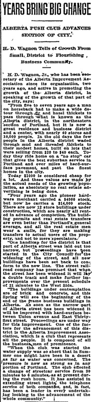
From The Oregonian, January 9, 1910
If you opened up the real estate section from any Sunday edition of The Oregonian during these early days you’d find a flurry of advertisements for these desirable lots. The new streetcar provided access, the lots were affordable compared to other new subdivisions elsewhere in town, money was relatively available to loan during the rising economy of 1910, and people were flocking to the area.
Of course, this caused its own problems, documented a few months later in the June 26, 1910 edition of The Oregonian:
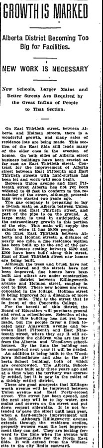
From The Oregonian, June 26, 1910
And by the end of 1910, Alberta was becoming so populated, neighbors were calling on the city to build a school.
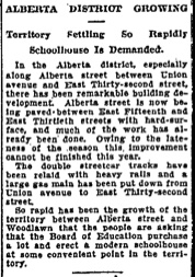
From The Oregonian, December 25, 1910
The problem of education infrastructure lagging behind neighborhood development was a trend across the eastside, which was successfully raised and driven by active and engaged parents (particularly moms). One might think this equation would be clear enough for neighborhood developers (homes + kids = need for schools), but their focus was on business and the sales of lots represented profit while the construction of school buildings represented only cost. Secretary Wagnon, a promoter through-and-through still preferred to focus on the immediate positives:
“One cannot get beyond the sound of the hammer or the sight of piles of lumber in this district.”
We like that sound-picture and can absolutely imagine what it must have been like on a weekday morning, closing your eyes anywhere along Alberta and hearing hammering and construction in every direction. That little details tells its own story.
Against this backdrop of growth and growing pains, local residents started some new traditions with unintentional echoes in the life of the district today. Market fairs for produce and hand-made products were springing up mostly as a matter of necessity for local residents.
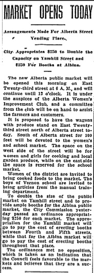
From The Oregonian, June 20, 1914
The open-air markets were a temporary fixture, but steady retail was shoring up its presence in the district. That’s where our bungalow grocery story will begin: construction of a store connected to a house at the northwest corner of NE 27th and Going, right in the heart of the construction boom.
Next up: In Part 2, 105 years ago, an older Irish couple moves to the neighborhood and opens a men’s clothing shop, which quickly becomes a neighborhood grocery.


Why would you call it the Alberta Arts District? That’s a term created by real estate folks who use it to profit from gentrification. It’s really a strip for bars and restaurants and boutiques, with not-very-much art, but that’s not the problem with it. Disappointed that you latched onto it without forethought.
Thanks for the feedback. I’ve changed the reference to be in line with the City of Portland’s Office of Neighborhood Association (ONA) map, which refers to this neighborhood as Concordia.
Your comment highlights the importance of place names and the complicated, sometimes ambiguous and overlapping references that exist to the same area. Names can represent years of accumulated meaning, or in this case a newly and not universally applied name to a well-known place that has experienced change. While ONA refers to this area as Concordia, the property is actually in a district originally known as “Lester Park,” which is the name of the underlying land survey plat filed on November 23, 1905. Because we value the presence of historic names, we’ve also updated the post to include this reference, though few people will likely recognize where Lester Park is. For some readers, Concordia gets closer to describing the area. And for others (for better or worse, to your point) the term “Alberta Arts District,” a label that appears in some real estate and local business district references, has some currency in establishing where this area is, even though it is not an official name. There are many references in the neighborhood’s early days to the “Alberta District” which seems like a reasonable descriptor. Some might even think of this area as Vernon, which is nearby but doesn’t actually begin until a couple blocks to the west.
We’ve written about the power of names and the complexity of place and identity here before: this post explored the conflict of place naming between Irvington and Alameda; and this post focuses on the distinction between a plat name (the official development map) and a neighborhood name, which is more of a government/social/political label.
Thanks for visiting.
I have a house on 31st and Sumner. The tax bills come to me as Foxchase Addition.
Here on the north side of Prescott, we are Alameda Park neighborhood. The neighborhood that traditionally is referred to as ‘Alameda’ — I believe is Olmstead Park and Rose City Park. Doug?
Many (most) paces get colloquial names as Doug suggests.
When the ‘Alberta’ district was being upgraded/refurbed/gentrified in the early ’90’s (thanks Magnus Johannesson) — some of the first businesses to move in, did lean to the ‘arts.’ I believe it was a valid name then, and it just stuck, maybe because of its alliterative appeal, even when all the bistros started moving in.