The Beaumont-Wilshire Neighborhood Association is inviting you to an evening presentation about the history and development of this northeast Portland neighborhood: Tuesday, April 1st at 7:00 pm. It’s free and pre-registration is required, which you can do here.
During our 90 minutes together, we’ll have a look back at photos, maps, newspaper articles and memories to create an understanding of the early days of the neighborhood as we look for connections between past and present. We’ll also examine the early forces that shaped Portland’s eastside and the excitement and boosterism associated with Beaumont subdivision’s big opening 115 years ago this month.
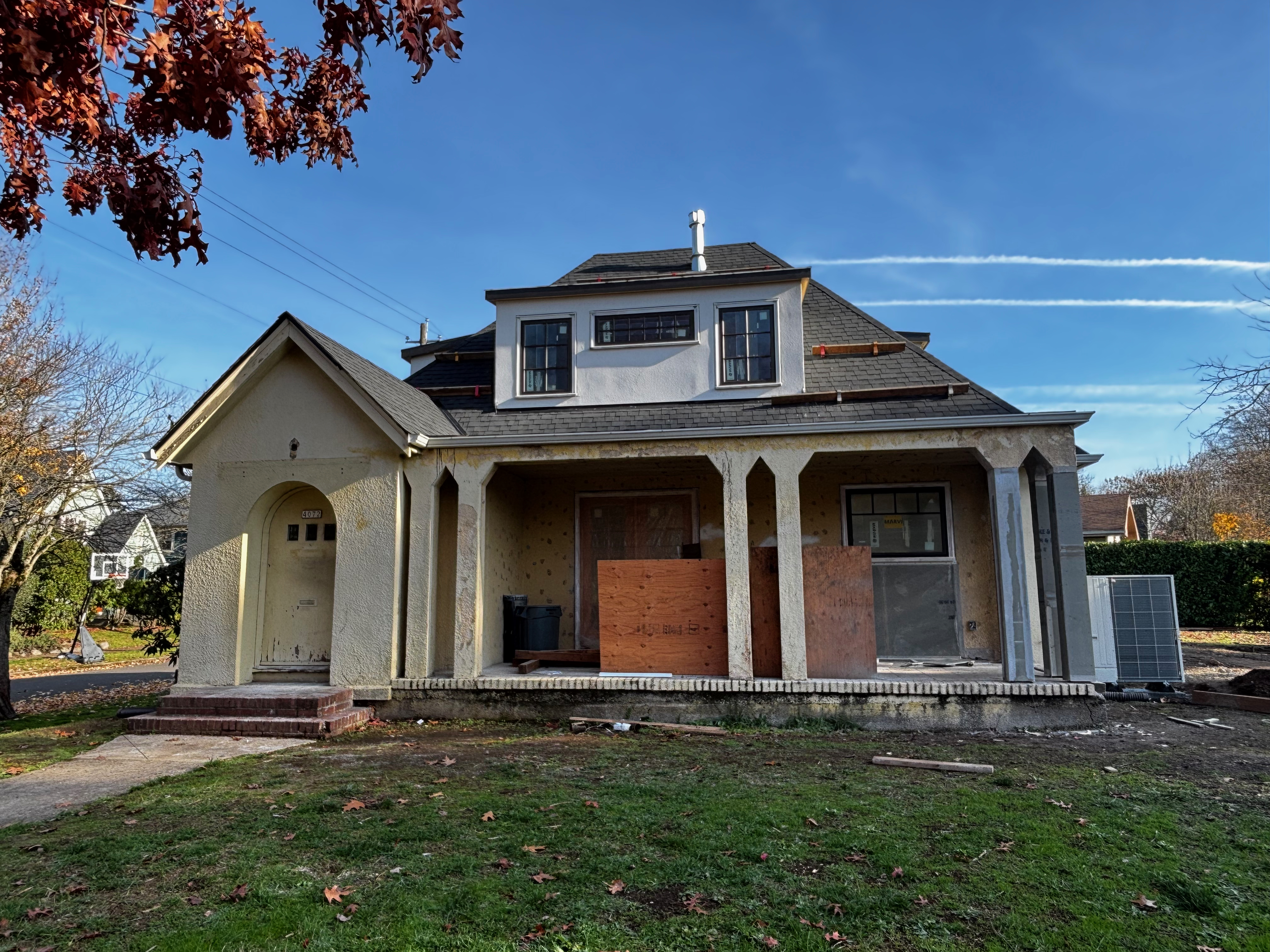
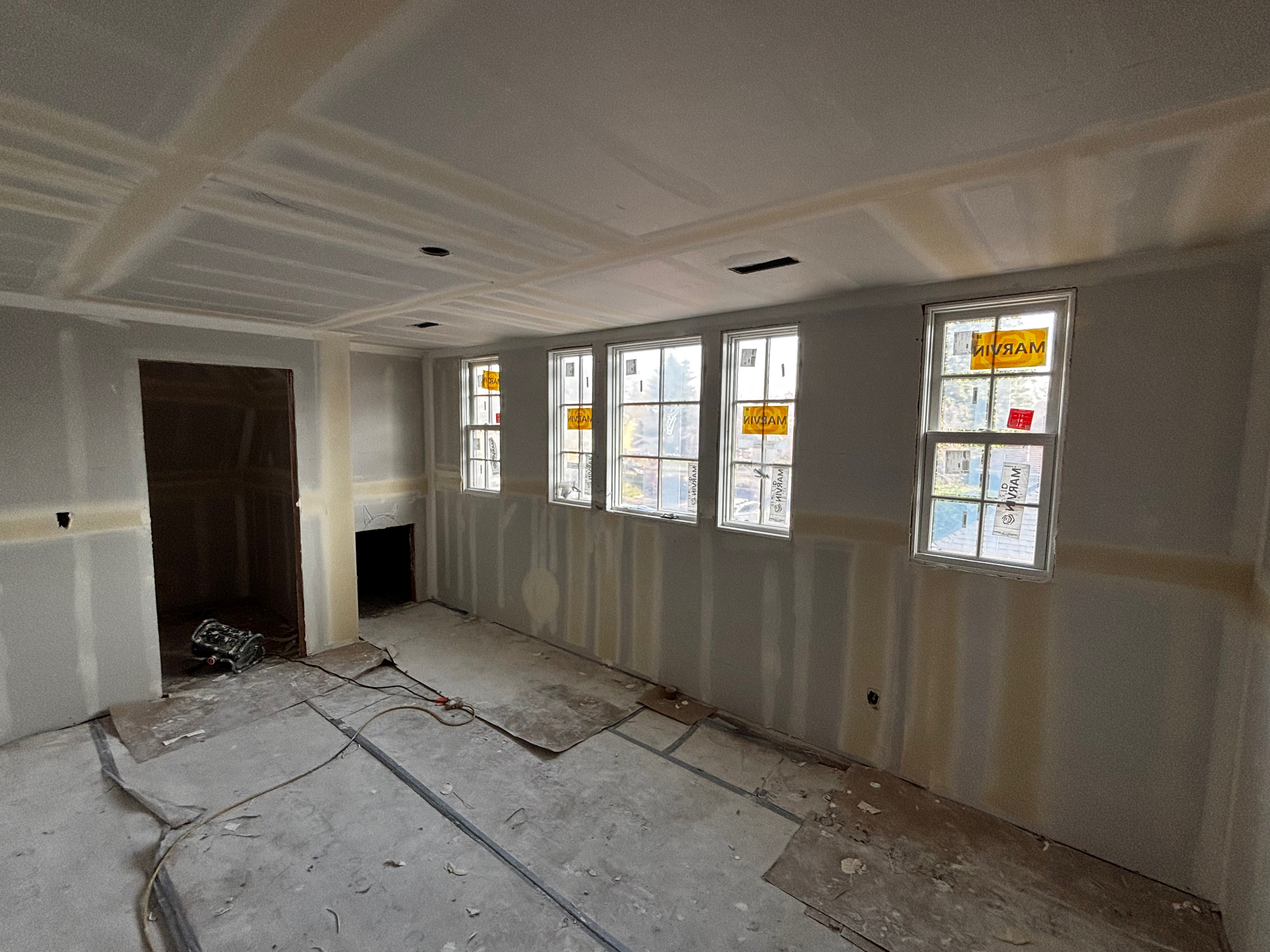
Neighbors interested in adaptive reuse of old buildings have had a front row seat this summer and fall as the von Homeyer house at NE 24th and Mason has been brought back from the brink of being a candidate for tear-down. Today, it’s on the cusp of its new life, with all of its systems transformed, spaces rearranged and upgraded, and virtually every interior and exterior surface either new or restored.
It’s as if the house is brand new: every window (the old ones were salvaged), all the doors, roof, heating (and now air conditioning), electrical, plumbing, floors, all wall surfaces, fireplace (the original mantel and built-in bookshelves are still there). Repaired and waterproofed foundation, new sanitary sewer line, fiber optics. Everything about the kitchen. It’s been a busy place.
NE 24th and Mason, photographed in December 2024. Note repaired front porch columns at far right.
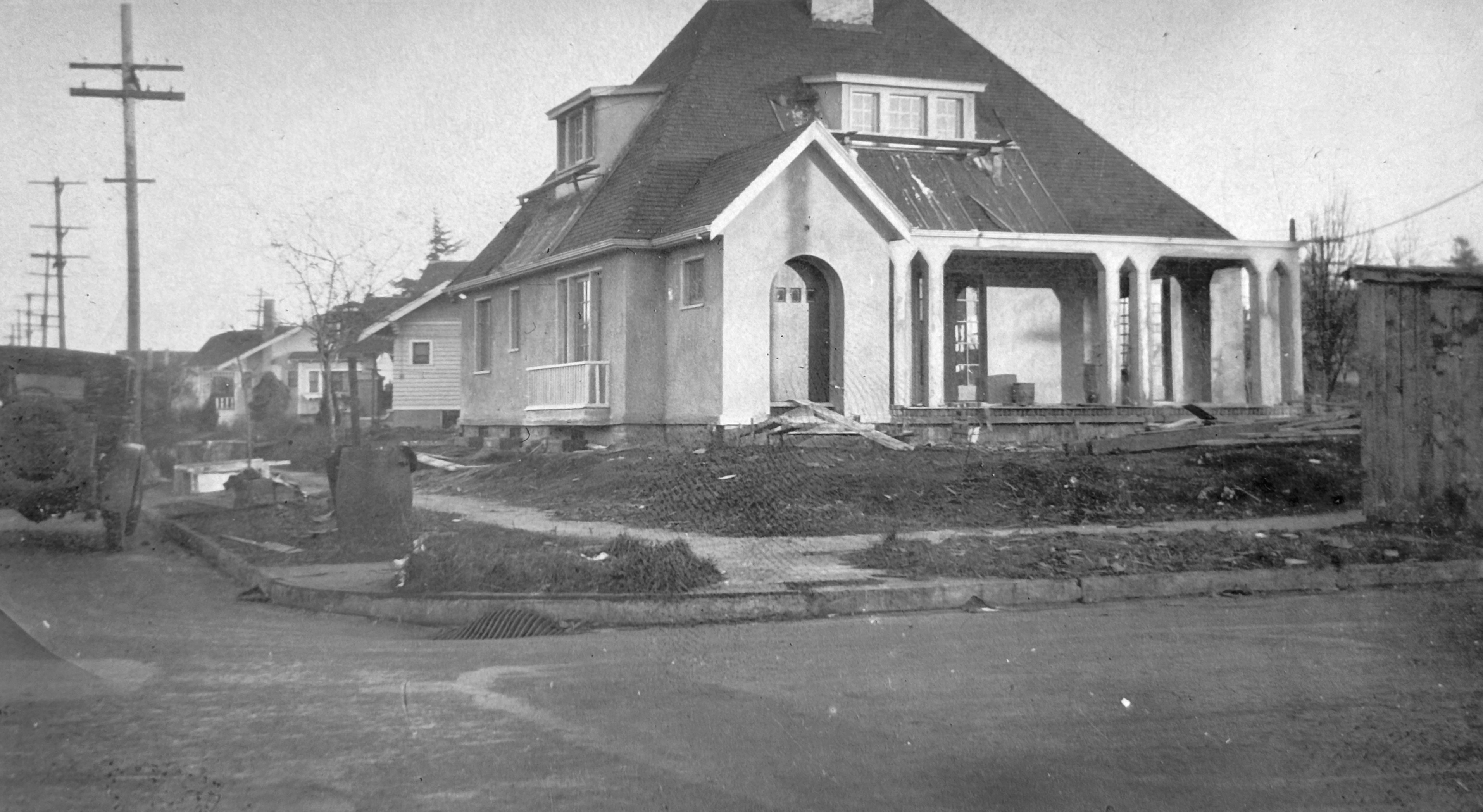
But still, when you see the “then” picture from 1925 when the house was built, and a recent photo from this December, it’s definitely the same time traveler, just transformed for its next 100 years.
AH readers will recall that neighbors Jaylen and Michael Schmitt bought the house earlier this year after the youngest son of the von Homeyer family, now in his 90s, moved to a care facility. The house had been in the same family for almost 100 years, and the brothers lived there their entire lives.
The Schmitts, like many in the neighborhood, were concerned the house would eventually be a tear-down and that something else built there could be an eyesore or worse. When they bought it, the house was jammed to the ceilings with boxes, papers and an incredible collection of items from several lifetimes. They reached out to us for help sorting through a trove of documents and curating some of the items. We re-homed 30 pounds of precious photos to far-flung family.
Four months of thinning and organizing led to a well-attended estate sale in May and gradually as the house was emptied, the Schmitts worked with architect Mary Hogue of MkM Architecture to plan for adapting the house.
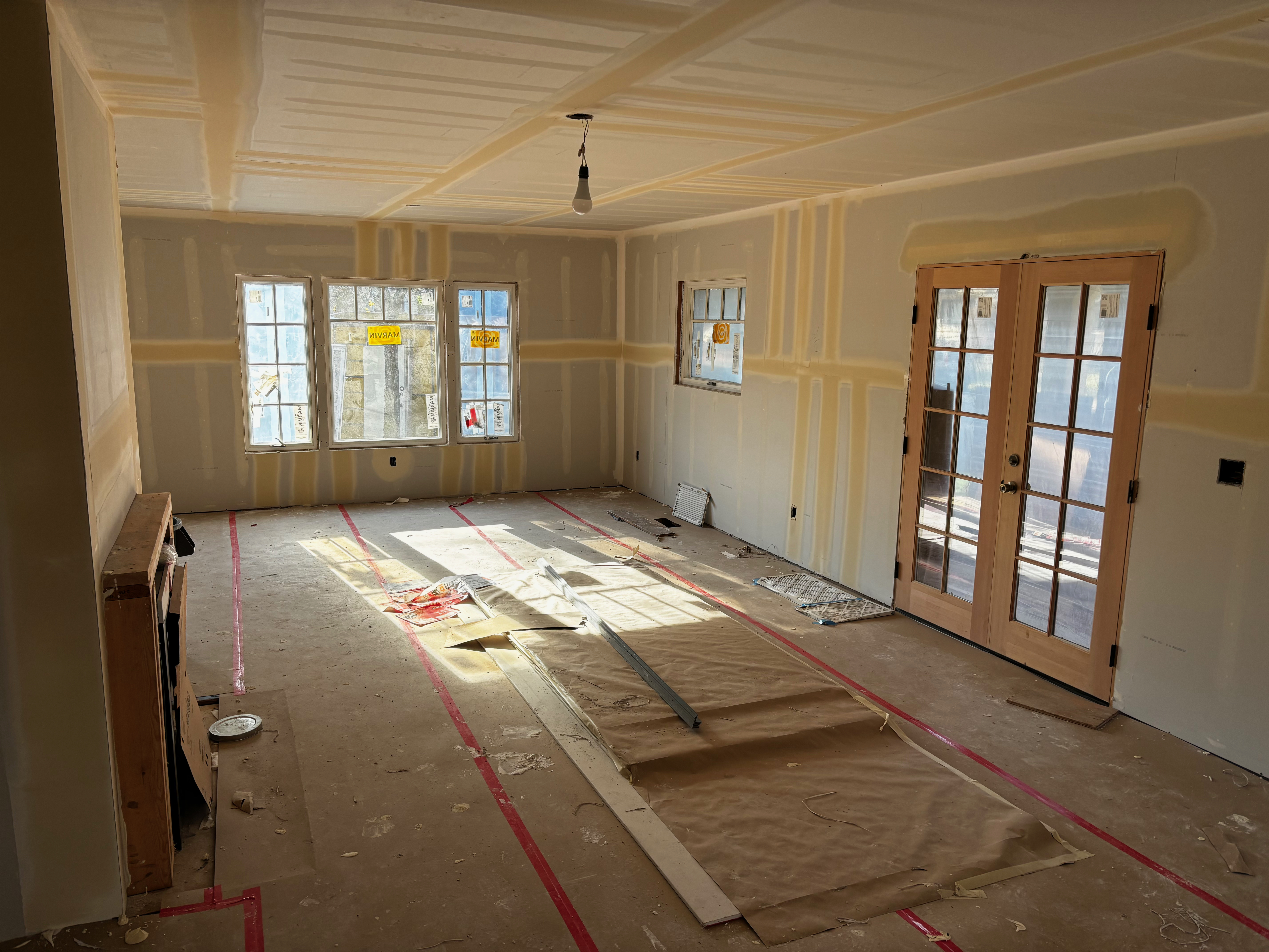
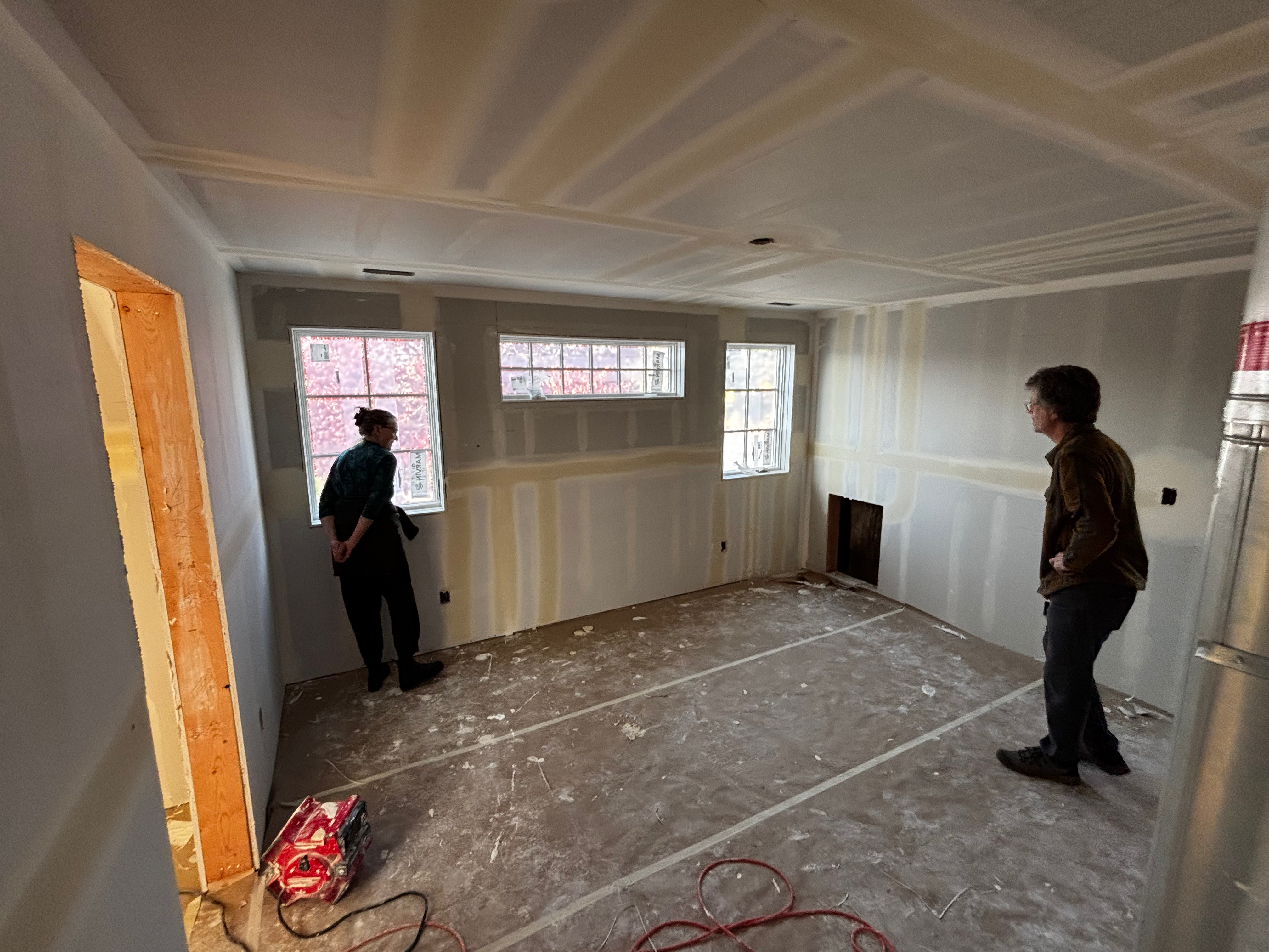
On the first floor, the existing bedroom and bathroom remain (all the plaster throughout the house has been replaced with drywall). The kitchen has been enlarged and will feature an island, two sinks and all the latest appliances. A newly re-opened and restored front porch is accessed by new french doors leading from the living room.
Looking into the living room / dining room. New French doors lead out onto the newly restored front porch. Framing is in, at left, for the fireplace.
The large kitchen features two sinks, will have a central island with cabinets, wall-hung cabinets all around, and a door out into the large backyard.
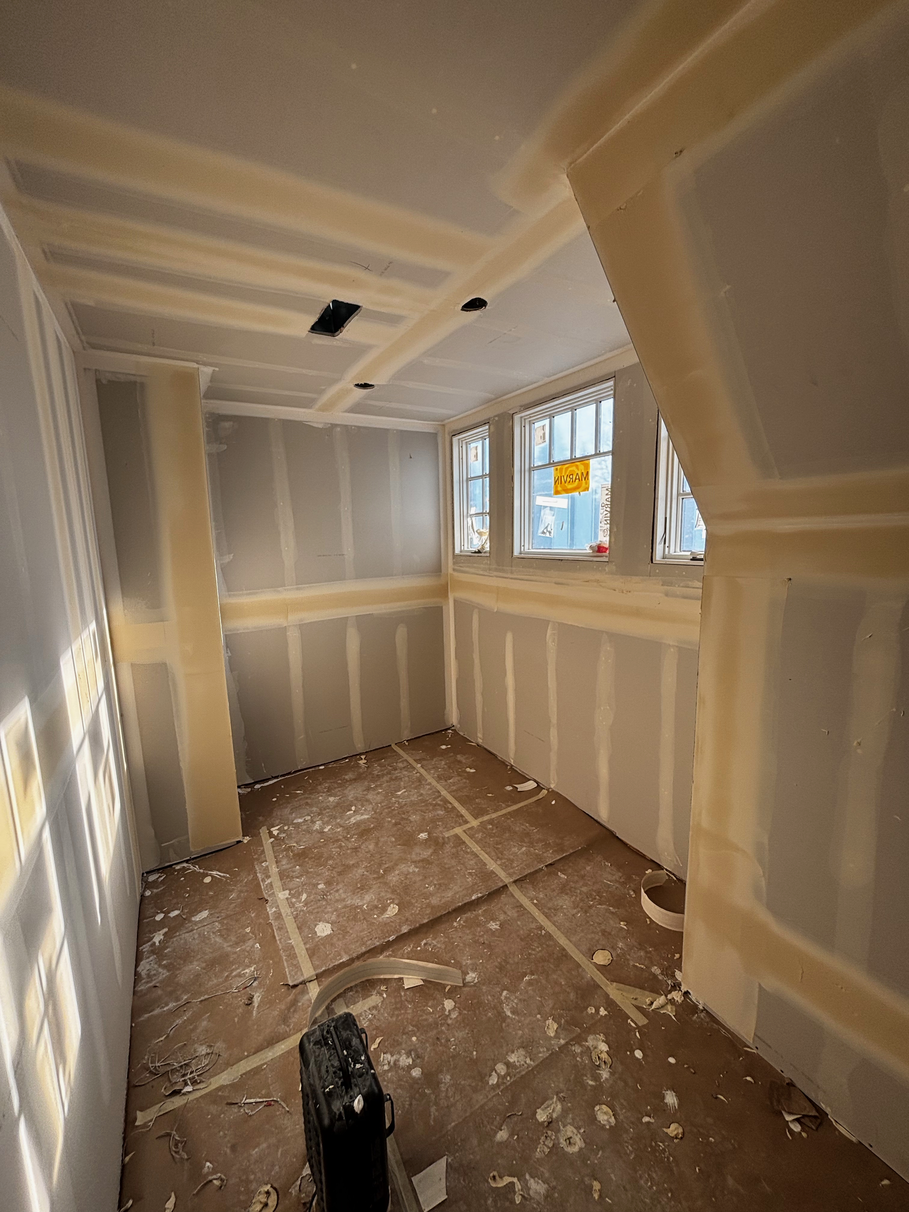
Upstairs, there are now two full bedrooms, each with its own bathroom, and a giant walk-in closet and dressing area with a huge bank of windows, and a combo washing machine/dryer.
This bedroom upstairs features lots of light and a large closet.
Upstairs, the primary bedroom features large windows and a giant walk-in closet to the left. An en suite bathroom is to the right.
The walk-in closet off the primary bedroom is filled with light.
In the basement: another bedroom and bathroom; a giant family room and entertainment area wired for surround-sound; and a utility room with washer/dryer and sink.
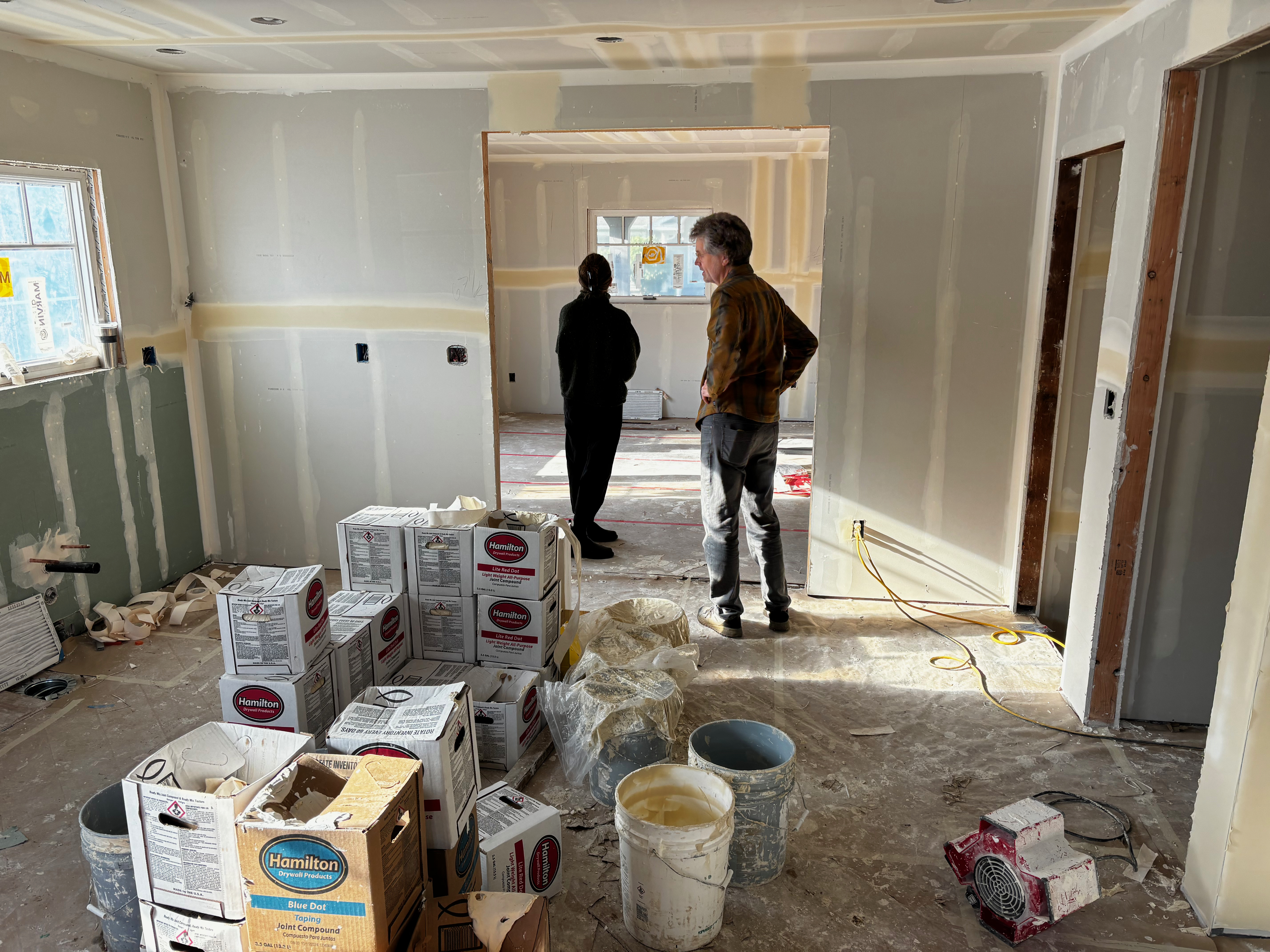
Michael Schmitt, who lives nearby, has been on site almost every single day. Michael is using a builder and subs to do most of the work, and calls himself a “heavily involved owner.” He says he’s become a very good “cleaner-upper.”
“I want to make sure this house is put together as expertly as possible,” Michael explains. So, he has had a parade of tradespeople helping: framers, plumbers, electricians, stucco experts, drywallers, HVAC experts.
It’s been stressful. Michael reckons he hasn’t had a good night’s sleep this year between worrying about what might be the next surprise, and trying to figure out the puzzle of transforming almost every aspect of the house.
“If I were to offer my earlier self some advice based on this year, I’d have to say ‘you’ve got to be 100 percent crazy to do this.’”
While it has been stressful, it’s also been rewarding in so many ways. First, the Schmitts saved the house and property from what surely would have been a much larger building (or buildings). That alone makes it worth all the work. But Michael has enjoyed working with a great team of experienced tradespeople, getting to know his neighbors better and saying hello to the daily stream of passersby, many of whom offer thanks and encouragement.
This week, work on the house is at about the 60-70 percent level. Last week was drywall installation and mudding. Yet to come: painting, trim and finish carpentry, plumbing fixtures, floors, kitchen cabinets (and everything about the kitchen). So many details. And then there is the landscaping, driveway, fencing. Still plenty of work to do.
Michael is hoping the house will be ready to put on the market in the spring. When that time comes, he’ll be ready to cross the finish line and welcome new neighbors. “This will end up being a year and half of my life,” he muses when reflecting on all the stages of the work so far. And while it’s been a journey of ups and downs, all the learning, progress, transformations and new friendships have helped make it worthwhile.
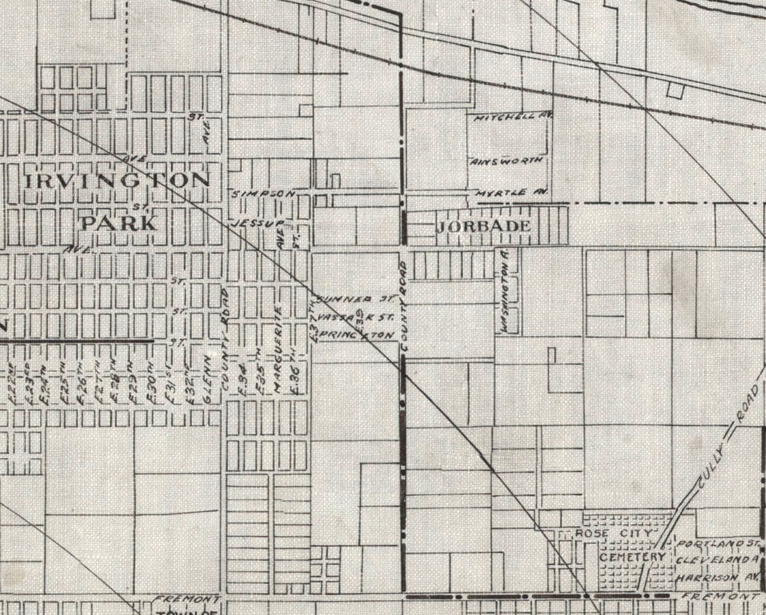
Detail from a 1908 Portland Railway, Light and Power Map showing the vicinity of 42nd and Killingsworth, in the center of the image. The Jorbade subdivision was platted at the intersection in 1908. The western “County Road” is today’s NE 33rd. The eastern “County Road” is NE 42nd. Rose City Cemetery appears in lower right (note that Cully passes through the cemetery).The cross-hatch lines indicate mile increments distant from downtown.TheIrvington Park plat is part of today’s Concordia neighborhood.The Alameda Park Addition had not yet been platted and is shown as open fields.
Continuing from our first installment exploring the layers of history at NE 42nd and Killingsworth…
The early years of the 20th Century brought a sea change to the Portland area: dramatic growth in population and a spike in residential and commercial construction that followed; a steady increase in the area’s rail and river shipping and port activity; extension of an interconnected electrified streetcar system; and arrival of the automobile. The 1905 Lewis and Clark Centennial Exposition drew national and international attention to Portland, attracted business and new residents, and set Portland on a growth curve that would remake the region.
During those early years, the vicinity of NE 42nd and Killingsworth was still a rural crossroads. Killingsworth (which was gravel) didn’t go farther east: it dead-ended into NE 42nd Avenue, which was known only as “County Road” up until the late 19-teens. Maps show the area much like the 1897 USGS map until the second decade: fields all around and less than 30 buildings—many of them barns—within a one-mile radius of the intersection.
But real estate speculators and some landowners could see the writing on the wall. Streetcar lines were working their way east, and new subdivisions and commercial areas were being planned and built. By 1912, a high volume of residential construction was underway in nearby Alameda, Beaumont and Rose City, all of which had been similar open fields and dirt roads.
Open lands are platted for homes, setting the stage for the area we know today
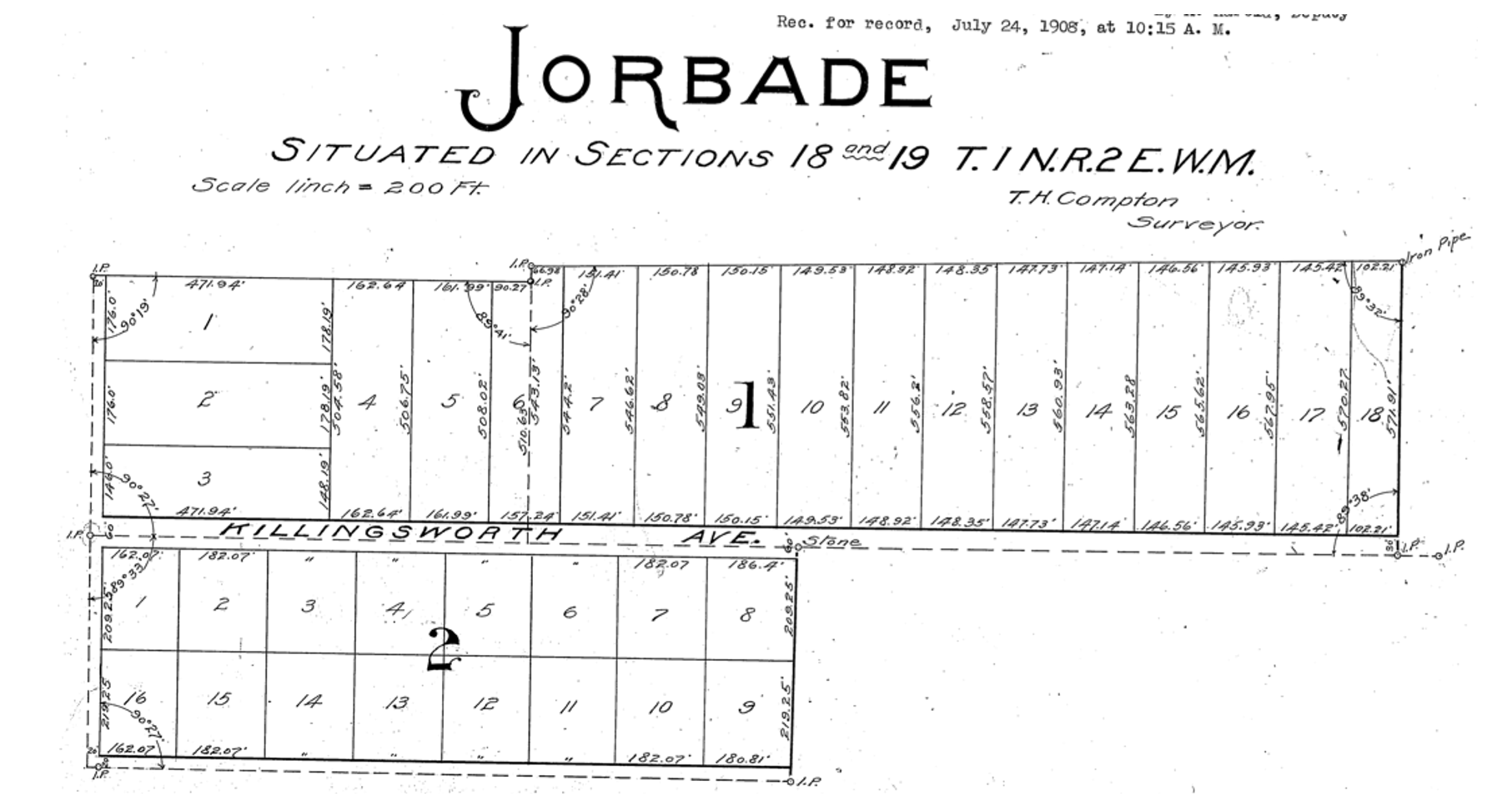
By 1909, real estate speculators Commodore Perry Jordan and Theodore August Garbade had purchased a portion of the old Isaac and MaryAnn Rennison Donation Land Claim at the intersection of today’s NE 42nd and Killingsworth. The two planned to sell residential building lots from what had been open farm land. Jordan and Garbade called their planned suburb “Jorbade,” and filed this plat with Multnomah County. The western edge of the plat is NE 42nd Avenue. Important to note that Killingsworth wouldn’t go through for at least 10 more years. These lots would be just that–vacant lots–for many more years.
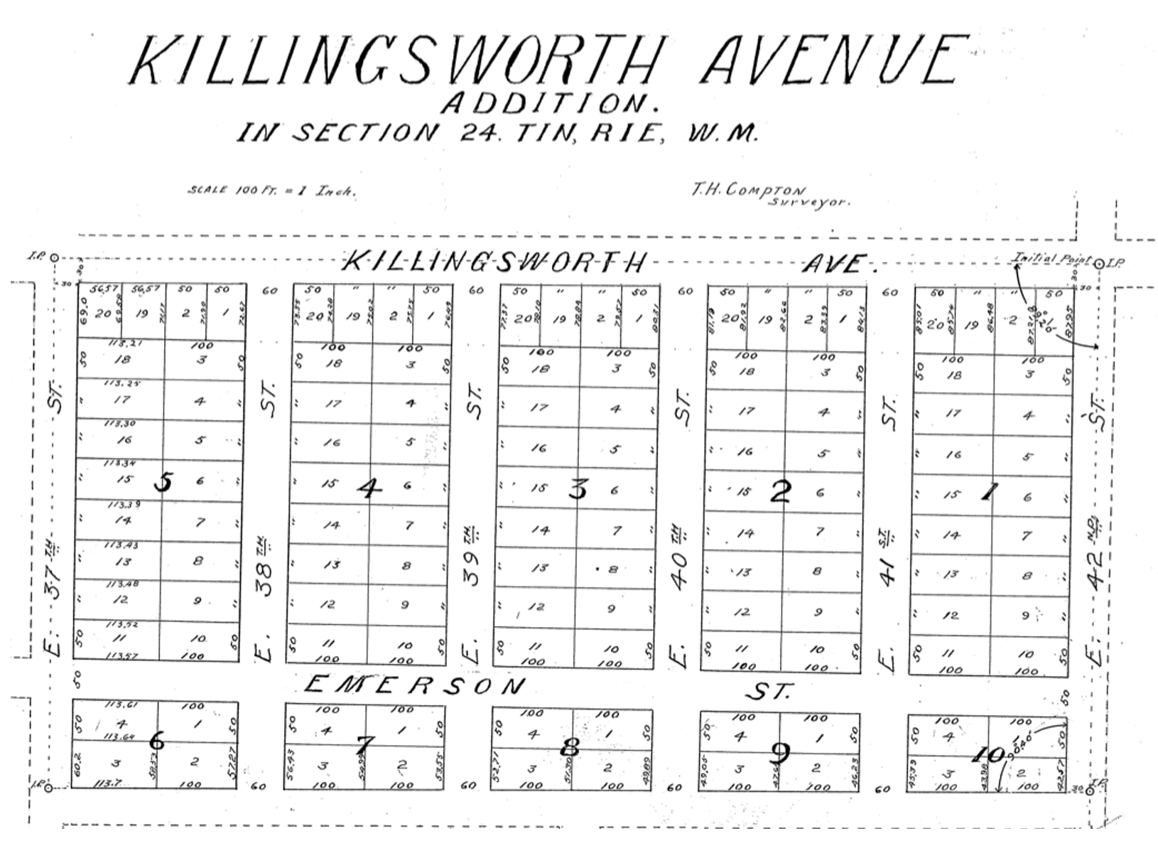
A few years later Jordan and Garbade acquired the lands on the opposite corner and were ready to convert them too from open fields to a subdivision. In 1911 they platted the Killingsworth Avenue Addition, from Killingsworth south beyond Emerson, between NE 37th and NE 42nd.
A bit farther west, local resident and real estate speculator John D. Kennedy was a few steps ahead of Jordan and Garbade. He had bought old homestead lands in 1880 believing that Portland would one day expand east; in 1890 he platted the Kennedy Addition, while this area was still part of its own town: East Portland. Here’s a detailed look at Kennedy and his adjacent nearby lands.
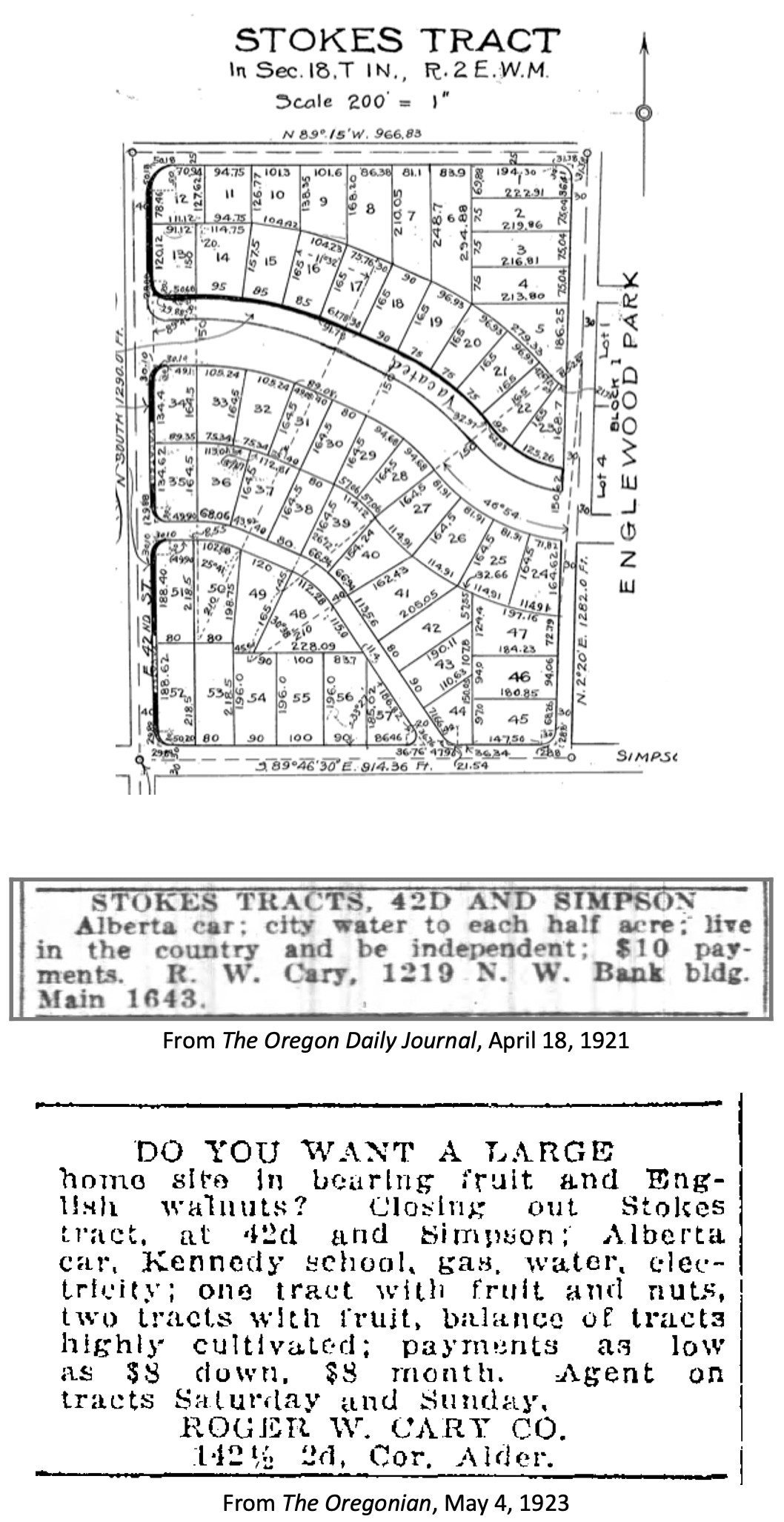
The Stokes Tract followed Jorbade and the Killingsworth Addition in 1920, north of Killingsworth and east of 42nd, establishing the graceful arc of Ainsworth and Simpson Court. This area retained a rural feel: “Live in the country and be independent” reads the advertisement.
Other subdivisions followed including tiny View Park in 1923, on the north side of Killingsworth between 36th and 40th:
Interest in these planned subdivisions was not particularly strong until the late 1930s: their distance from downtown, their presence outside the city limits and about a mile walk from the nearest streetcar line (despite what the advertisement said about being on a 5 cent fare line); their rural nature including gravel roads and surrounding fields and orchards may have made them less attractive, even if the prices were lower. But as Portland continued to expand, and the automobile became more prevalent, would-be homeowners were ready to buy and build.
Classified advertisements for properties adjacent to the intersection report a variety of crops growing at the time: orchards of Bing, Lambert and Royal Anne cherries; English walnuts; Bartlett pears; prunes and plums; apples; rows of strawberries and raspberries.
Often referred to as “truck farms” because the produce was trucked to market (and some of it was sold out of the back of trucks at busy intersections and small markets around town), these surrounding fields produced fruit and vegetables for Portland households. One farm near the corner of what is today’s NE 41st and Holman was owned and run by a Japanese immigrant family, as were others in the area. During WWII, Japanese farming families across the Pacific Northwest were removed from their land and placed in internment camps in southeast Oregon, central California, Idaho, Utah, Wyoming and Colorado.
Portland Air Base leads to new roads and new residents
By 1935 air freight and airline passenger traffic had overwhelmed Portland’s first airport—located on Swan Island—and the city spent $300,000 to purchase a 700-acre site adjacent to the Columbia River where today’s Portland International Airport resides. With a grant from the Works Progress Administration, workers drained the former floodplain and dumped more than 4 million cubic yards of sand across the site. The airport opened in 1941. During the hundreds of generations of indigenous presence prior to European contact, these wetlands had been both seasonal home and food source.
Following declaration of war in late 1941, Army Air Base operations at the site were dramatically increased and Portland became a regional magnet, attracting tens of thousands of workers and their families to multiple war-related industries across the Portland area. An immediate demand for housing, combined with a newly-improved road network and the availability of open land in this area so close to the airbase, fueled interest.
A small expression of the interest was a long row of connected cabins dubbed the “tourist cabins” and an adjacent business called the Spur Tavern at the northeast corner of NE Holman and 42nd avenue. Built in 1942 as temporary housing for the great influx of people, the residences and tavern became a landmark of sorts. Read more about the Tourist Cabins and the Spur.
City buys old farms to create Fernhill Park
After voters approved a property tax levy in 1938 to create more parks and playgrounds for a growing Portland, the city set out on a 10-year process of buying the hills and gullies northwest of 42nd and Killingsworth, starting out in 1940 with a 10-acre parcel owned by the Jackson family right in the middle of it all.
Prior to acquisition, several dirt roads criss-crossed the north side of the area, one even ran right up the bottom of the gully at the heart of today’s off-leash area in the northeast corner of the park, pausing at a wide spot that served as a dump and debris field where car bodies and all manner of junk were strewn.
It wasn’t an official dump, but more like a secluded out-of-the-way place where residents from the surrounding area dumped unwanted items. In the late 1930s and early 1940s, when the NE 42nd Avenue connection to Columbia Boulevard was built, some of the dirt fill needed to make the grade change for the overpass was dug out from and supplied by the gully on the east side of the park along today’s NE 41st Avenue.
As the park took shape through the late 1940s and early 1950s, some locals referred to it as Ainsworth Park, a name that appears frequently in real estate advertising of that era. By the early 1950s, most of the open land to the north of the park had been converted to subdivision (the Vanlaeken and Leitritz plats). NE Highland Street was put through the middle of working farmland as the area was transformed into suburbia. By June of 1951 when most of the park buying was done, the city had invested $60,479 total for all of the parcels and had acquired 25.95 acres. Read more about the origin of Fernhill Park.
Aerial photographs = time travel
As a reward for reading this far, and as preface for the next installment, here’s a series of aerial photos that allow us to witness change. Each of these is fascinating, so click in for a detailed view. Observations follow each image. Aerial photoscourtesy of the University of Oregon Map and Aerial Photography Library.
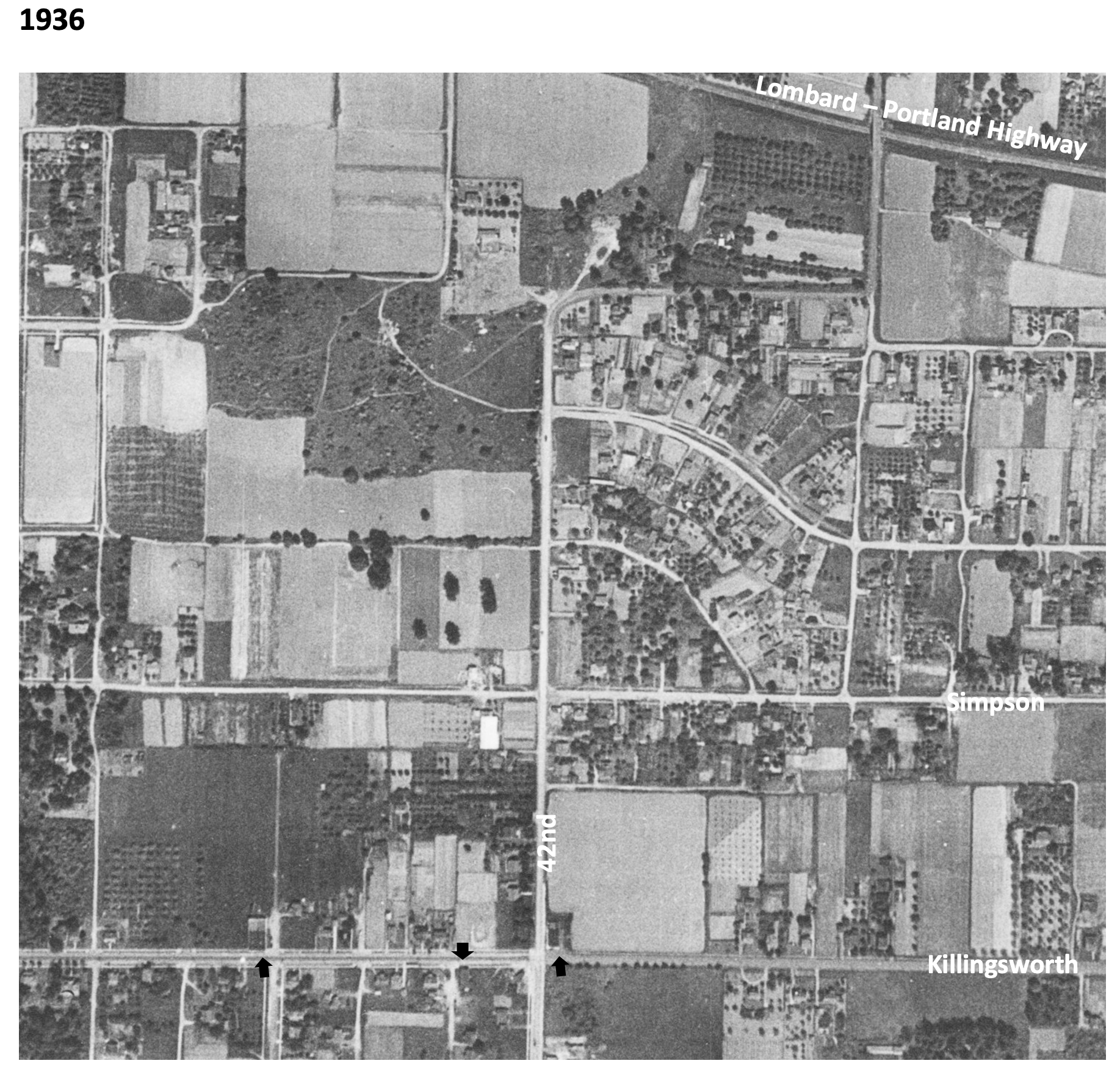
In 1936, the unplowed lowlands of today’s Fernhill Park show up just left of center, and the arc of Simpson Court and NE Ainsworth feed into NE 42nd. No viaduct yet over Portland Highway. The arrows indicate locations of three small mom-and-pop groceries. Note that Simpson goes through east-west, across the middle of today’s Fernhill Park.
In 1939, more houses are showing up, and orchards in the center of the photo are maturing.
In 1948, the 42nd Avenue viaduct is in place (not pictured) connecting NE 42nd to the new Portland Airport. Houses continue to replace open fields. The greenhouses at Knapps Nursery appear west of NE 42nd at Simpson.Orchards near NE 37th and Killingsworth are replaced by homes.
In 1951, a trailer park appears at the NE corner of 42nd and Killingsworth in what were once open fields. Significant new home construction is evident north of Killingsworth and west of 42nd. The flat playing field at the south end of Fernhill Park begins to emerge from the former agricultural fields north of Simpson, and west of 42nd.Construction is underway on the new St. Charles Churchand school.
In 1961, the trailer park is replaced by a large Safeway store and parking lot at the corner of 42nd and Killingsworth, which opened in 1957. A baseball diamond is clearly visible in the new Fernhill Park. Orchards and open agricultural fields are gone.Simpson still goes through west of Killingsworth.South of Simpson in this area, 26 homes, three duplexes, a PGE power substation, and Knapp’s greenhouses and nursery are soon to be demolished or moved–over the strenuous objection of neighbors–to make way for John Adams High School.
In 1971, John Adams High School is in place, replacing a portion of the open areas of Fernhill Park and most of the homes between Killingsworth and Simpson west of 42nd. Simpson no longer goes through west of 42nd. Acres of parking are available west of the Safeway storeat 42nd and Killingsworth.
By 2020, John Adams High School (later known as Whitaker Middle School) was demolished in 2006, but the track remains. Neighborhood street tree canopies are filling out.Safeway is closed and the buildings at the northeast corner of 42nd and Killingsworth are now gone.
The intersection of NE 42nd and Killingsworth can feel like it exists on the way to somewhere else. But this crossroads has its own rich history that runs deep.
NE 42nd and Killingsworth, looking northeast. Fall 2023, Google streetview.
It’s worth slowing down time a bit to be able to see and explore the chapters here, which run back through commercial retail and early neighborhood development to wide open fields of berries and orchards, further back through the homestead era and even down slope toward the Columbia River and the slough wetlands that have been known and inhabited by Chinookan people since time immemorial.
This is the first of a three-part exploration to spark your imagination about the layers of history here. In this first installment, we’ll overview the arc of the story. In the second installment, we’ll take an illustrated deep dive into the subdivision years between 1900-1940 when everything was changing for the neighborhoods around the crossroads. Our last installment will explore the changing look of the intersection itself from the 1950s-1980s: gas stations and mom-and-pop groceries, greenhouses, a Safeway store, a trailer park, Adams High School and more.
Today, both NE Killingsworth Street and NE 42nd Avenue are well-used surface streets in the Northeast quadrant of Portland. The traffic-controlled intersection where they cross—poised at the northern edge of the 42nd Avenue / western Cully neighborhood commercial area four miles from the downtown core of the city center—features restaurants, bus stops, a convenience store, direct access to a city park and a brand-new workforce training center operated by Portland Community College. In fall 2025, Home Forward will open 84 units of affordable housing here. This is a busy place.
Early slopes above the Columbia Slough
For millennia the uplands south of the Columbia Slough and Columbia River were covered by a mixed forest of Douglas-fir, hemlock, cedar, alder and maple. Periodic fires, windstorms and outbreaks of insects and disease created openings in the forested canopy. The upland plateau that would eventually become the vicinity of today’s NE 42nd and Killingsworth sloped gently down to meet a vast flood plain, which followed an east-west line at the foot of the slope traced by today’s NE Columbia Boulevard.
Situated between the bottom of the slope and the main channel of the Columbia River just to the north was an interconnected flood plain mosaic of wetlands, ponds, marshes and off-channel waterways. Chinookan seasonal gathering places and dwelling places thrived here for thousands of years.
“Interior of Ceremonial Lodge, Columbia River,” an 1846 oil painting by Paul Keane, who traveled among the Chinook villages of the lower Columbia River.
Explorers, trappers and traders passed by on the Columbia River in the early 1800s intersecting the lives of indigenous people who had known this area since time immemorial. Early white traders introduced successive epidemics of disease, disruption and depredation, and by the 1830s the Chinookan people’s settlements in this area and their ways of life had been dramatically changed. By the late 1840s, Oregon Trail settlers arrived in the area; this immediate vicinity was homesteaded by several families practicing a mix of agriculture, trade and subsistence. Forests were removed, roads were constructed, and homes and barns built.
Surveys gridded the land
With the opening of the Oregon Trail in the mid 1840s and arrival of an increasing number of outsiders seeking land for farms and homesteads, the U.S. Government established a systematic process to map and identify lands that had been mostly cleared of indigenous people that could be granted to newcomers. Survey crews got to work here in the Portland area in 1851 establishing the Willamette Meridian, a systematic grid of townships, ranges and sections across the territory and the Western U.S. that promoted the availability of lands.
Today’s intersection of NE 42nd and Killingsworth exists at the corner of four sections of the Willamette Meridian: Township 1 North Range 1 East, sections 13 and 24 to the west; Township 1 North, Range 2 East, sections 18 and 19 to the east. Here is a compilation of those two original survey maps (click in for a closer look, they are fascinating). Observations below.
On the left is Township 1 North, Range 1 East. Notable are the early grid of a young Portland in the lower left; the location of past forest fires; the proximity of early trails and the complex waterways that make up the Columbia Bayou to the north. The blue arrow indicates the approximate location of today’s NE 42nd and Killingsworth. On the right is Township 1 North, Range 2 East. Notable here are the “wet prairie” description of the Columbia Slough bottomlands in the vicinity of today’s Portland International Airport; the road running northeast, predecessor of today’s Cully Boulevard; the surveyor’s descriptors—land gently rolling, soil 2nd rate, gravelly. Timber, Fir, Hemlock, Maple—describe vegetation in the area at the time; Rocky Butte shows up as the raised topography in the center of the map.
In October 1851, surveyor Butler Ives and his crew walked all through this area in order to draw these maps, and characterized what they saw like this:
Upland situated in the middle portion of the township is gently rolling and is elevated from 50 to 100 feet above the adjoining bottoms. The soil of the above is nearly uniform and good second rate clay loam and some gravelly in the northeast portion south of the Columbia bottoms.
The bottom lands both of the Willamette and Columbia, is from 5 to 15 feet above low water, the most elevated being along the banks of the rivers and bayous; they are subject to an annual inundation lasting from 1 to 2 months in the summer season, leaving only a few of the higher places dry. They are mostly open grassland. Soil rich alluvial and badly cut up with bayous, stagnant ponds and lakes which render nearly one half of them unfit for a cultivation.
The timber on most of the uplands is heavy and varies from 1 to 2 and in some instances to 250 feet in height. It is principally fir with a little maple, cedar, hemlock and dogwood interspersed.
The undergrowth is vinemaple, maple, brush and is usually thick; there is considerable dead and fallen timber caused by fire which has run through most of this Township.
In the bottoms is ash, willow balm, Gilead, crabapple with oak, and is found skirting the banks of the rivers and bayous. The undergrowth is in thick mixture patches of hardwoods, rose bushes gooseberry bushes and vines. The Columbia bayou is deep in most places and will admit boats drawing several feet of water. The other bayous are generally shallow.
As more people arrived, the surrounding lands were further divided, sold and developed. Wetlands to the north were drained for agriculture. More roads were built and active steamboat commerce developed on the nearby Columbia River. In 1882, a short stretch of dirt road in the growing nearby town of Albina was dedicated as Killingsworth Street, named for prominent real estate developer William Killingsworth. One year later—1883—the Oregon Railway and Navigation Company opened an east-west rail line passing nearby to the south that connected Portland with a growing network of regional and national railways.
A patchwork emerges
Our crossroads was well outside the eastern boundary of East Portland, which in 1891 consolidated with the towns of Albina and Portland (on the west side of the river) to form the single City of Portland. A rough north-south gravel trace known as the County Road (today’s NE 42nd Avenue) was carved out connecting the east-west predecessor of today’s Fremont Street with the east-west road along the Columbia Slough (today’s Columbia Boulevard). Growing population and commerce continued to boost Portland’s expansion. By the turn of the century, lands that 50 years earlier had been taken from indigenous people and deeded by the federal government to a handful of incoming families were being subdivided and sold into hundreds of parcels.
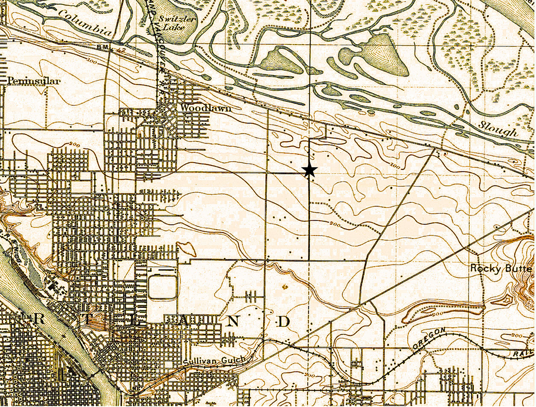
A patchwork of agriculture and development dotted the surrounding landscape with small farmsteads of orchards, berries and vegetables interspersed with homesites. Below is a detail from a USGS 1897 map of the area (star shows location of NE 42nd and Killingsworth). Notable here is that Killingsworth does not go farther east; development does not proceed much farther east than NE 7th; scattered farmsteads occupy the area of today’s neighborhoods; the Irvington race course at NE 7th and Fremont shows up in lower left.
Because of the area’s distance from the downtown core, its location beyond easy access to the streetcar system which promoted development, and its agricultural productivity, the crossroads remained largely rural until the opening of Portland Airbase in 1941, which was then a brand-new facility built on the reclaimed floodplain wetlands just south of the Columbia River.
Post-war boom ignites interest
The wartime expansion of manufacturing, residential growth and military operations drew new attention to the area, leading to transportation improvements and northern extension of NE 42nd Avenue with a viaduct over the Columbia River Highway, making it a major throughway from the eastside to the airbase. Residential and commercial development followed. Portland’s post-war housing boom in the 1950s led to further development, including more subdivisions, construction of a busy trailer park at the northeast corner of the intersection, and city acquisition of remaining nearby farm lands into what would become today’s Fernhill Park just to the northwest.
By the 1960s the area had been annexed into Portland proper. A commercial hub had developed at NE 42nd and Killingsworth including large and small grocery stores, service stations, bars, restaurants and light manufacturing. In the mid-1960s, the Portland School Board condemned a portion of the surrounding area to build John Adams High School, in direct opposition to residents’ wishes, razing homes and businesses. The school complex was later transitioned into Whitaker Middle School, and eventually torn down in 2006 due to changing student demographic needs and concerns about radon gas and the presence of unhealthy black mold found throughout the building.
Looking southwest at the corner of NE 24th and Fremont, early 1920s. Note delivery bike visible behind power pole. OrHi 49061.
In collaboration with the Alameda Neighborhood Association, I’ll be presenting a local history program Wednesday, March 1st from 7:30-9:00 p.m. at the Fremont United Methodist Church (2620 NE Fremont), and you’re invited (RSVPs required, see below).
Using early maps, documents, photos and newspaper accounts—and memories collected from past residents—we’ll explore how forests and fields defined the landscape of Portland’s eastside. Then, as a young city sprawled across the river, the rural landscape was replaced by a grid of neighborhoods, a busy streetcar system and tens of thousands of new residents. Successive waves of homebuilding and change in the decades that followed shaped the neighborhoods we know today.
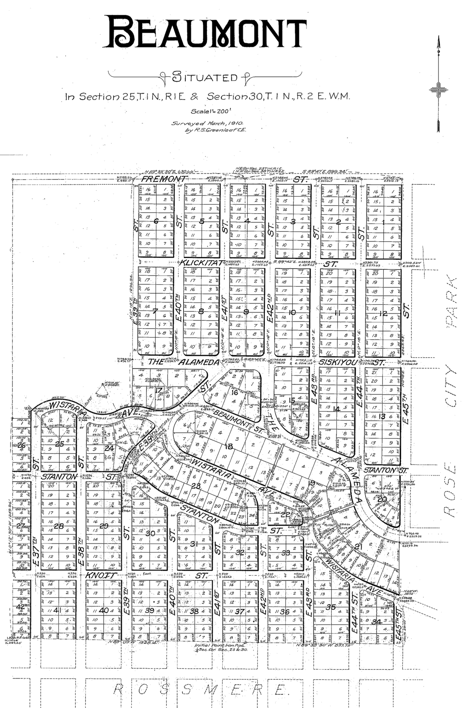
This illustrated one-hour program explores the early years of Alameda, Beaumont-Wilshire, Sabin, Vernon, Concordia, and Cully as we examine connections between past, present and future.
To reserve your spot for the March 1 program, e-mail the Alameda Neighborhood Association at alamedanewsletter@gmail.com. Reservation deadline is February 24th. Doors open at 7:00 and the association will have light refreshments on hand.
The Alameda Neighborhood Association is a neighbor-led board that advocates for smart policies, takes action on neighbors’ concerns, facilitates communication about neighborhood issues, hosts events to bring residents together and publishes the quarterly newsletter AlamedaPDX.
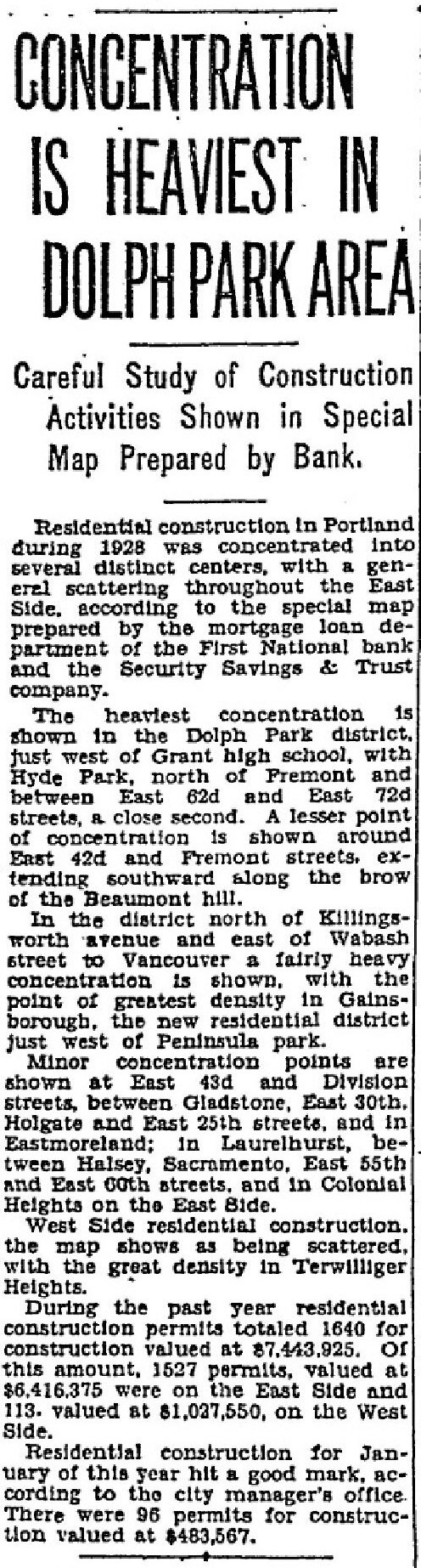
We’ve often wondered about Dolph Park: the island of tall trees, large houses and lush landscaping a few blocks west of Grant High School in Northeast Portland. Who were the Dolphs? How did this place come to be? What was here before?
Today a subset of the Grant Park Neighborhood, Dolph Park feels like its own place, distinct from the smaller streets and lots immediately to the east in the Fernwood Addition. The homes are younger than in Irvington to the west. Buffered from the mixed commercial uses to the south on Broadway. And distinct from smaller homes and lots to the north in Waynewood.
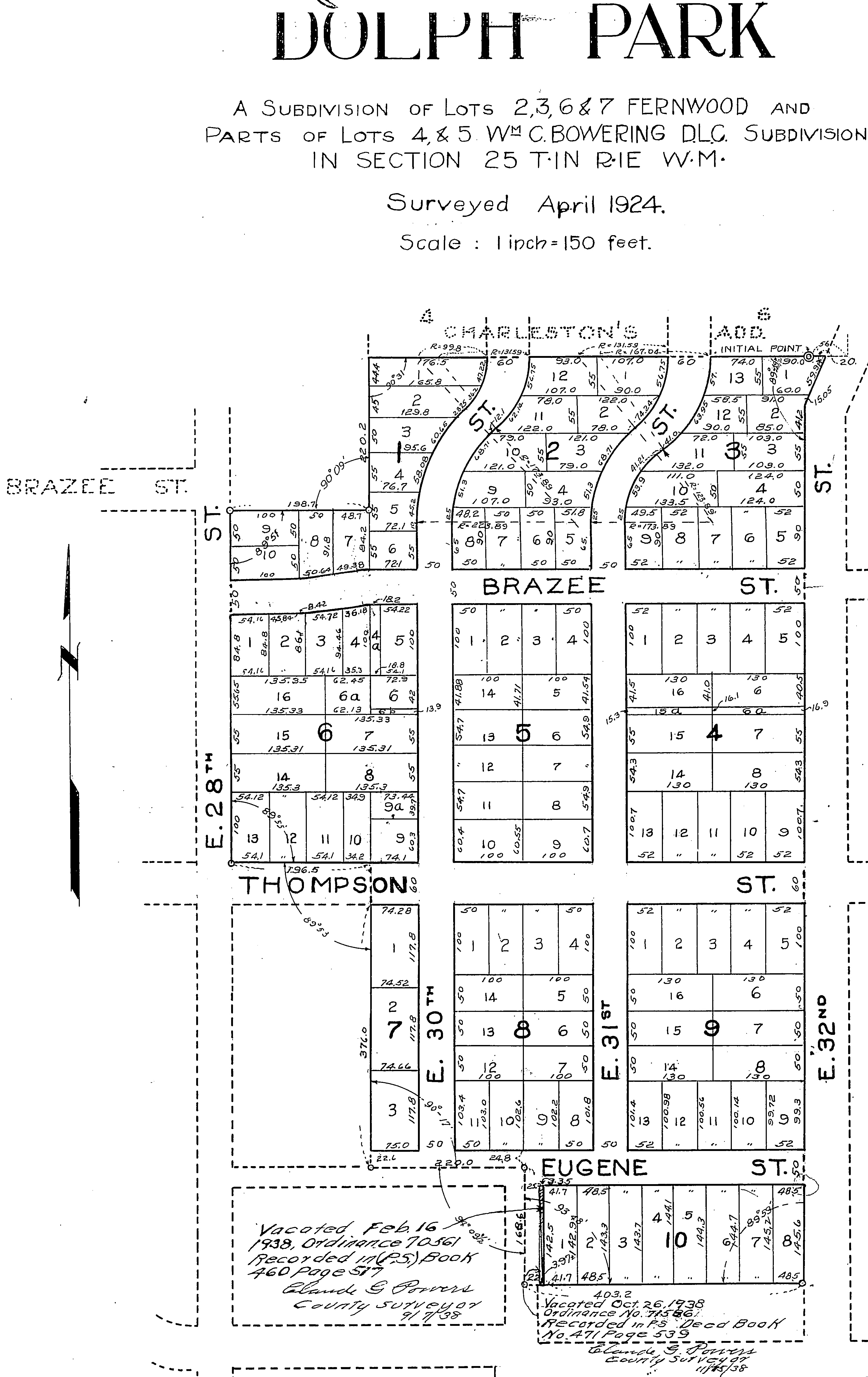
This is the Dolph Park Plat, filed with Multnomah County in April 1924. The notes at the bottom show portions of lots vacated along NE 30th between Eugene Street (today’s U.S. Grant Place) and NE Tillamook. Courtesy of Multnomah County Surveyor.
For a subdivision of its size—10 blocks and 122 lots—it arrived relatively late on the scene. It is unusual for so much open land so close in to have been unbuilt for so long. Part of that had to do with complex property ownership and legal wrangling. But when it did come to market, during the boom years of the mid 1920s, it didn’t take long to sell.
Development of Dolph Park, like other subdivisions in Portland at the time, was premised on strict racial prohibitions written right into the deeds that prohibited any other than white families living here.
Dolph Park restrictions also required minimum new construction costs which were at the high end for new construction at the time. Homes facing NE Thompson Street, which the developers clearly wanted to make the showcase street of the neighborhood, required even higher minimum construction costs.
Dolph Park was platted in April 1924 by Eliza Cardinell Dolph (1849-1934), matriarch of the Dolph family which was influential in Portland in the late 1800s and early 1900s. Eliza was the widow of Cyrus Abda Dolph (1840-1914), who had a long list of legal and civic accomplishments, including serving as Portland City Attorney, helping found Reed College, serving as lead attorney for the Northern Pacific Railroad, director of the Oregon and California Railroad, president of the Library Association of Portland and other positions. Cyrus’s brother Joseph Dolph was a two-term U.S. Senator from Oregon. Clearly, Eliza and Cyrus—and their three children—were amongst the most well off of Portlanders and the family controlled property in every quarter of the city.
Cyrus A. Dolph, about 1911 (left); Eliza Cardinell Dolph, about 1868 (right)
The property that is today’s Dolph Park, however, came to Eliza through her own side of the family: the Cardinells. Her parents Charles and Jane Cardinell arrived in Oregon in 1865 and acquired land as the city grew, amassing a small fortune. When Eliza’s father died at age 85 on August 22, 1907, real estate, investments—and several very valuable musical instruments including a Stradavarius violin—came to her and to her brother Charles B. Cardinell. Included in the estate were two tracts of property: one in the Fernwood Plat and one which was part of the Bowering Donation Land Claim, both between NE 28th and 32nd Avenue, from Thompson to Tillamook.
These properties had been owned by her parents from the moment they were platted by Hannah W. Smith in May 1887 as part of the Fernwood Addition. Real estate transfers show the property going directly from Hannah Smith to Eliza’s parents Jane and Charles Cardinell, and some properties to her younger brother Charles B. Cardinell (1858-1923) as well.
During the late 1800s and early 1900s these open lands were cultivated with berry and orchard crops. Small-scale farming and grazing occurred as other nearby neighborhoods began to grow. Today’s Northeast 33rd Avenue was a constant presence: first, a dirt-track county road that marked the edge of city limits; then increasingly a through-way for access to agriculture along the Columbia Slough; then prime access to booming brand-new nearby residential neighborhoods.
In the early 1920s, with the explosion in real estate values all around these undeveloped lands—Irvington to the west, Waynewood and Alameda to the north, Beaumont and Rose City Park to the east—Eliza Dolph recognized the attractiveness and marketability of her long-held family properties. Following the death of her brother in 1923 and the settling of his estate, she brought together the Cardinell properties with those owned by four other families to create Dolph Park. The plat was filed on June 30, 1924, containing 10 blocks and 122 lots.
The first classified advertisement for property in the “beautiful wooded tract” appeared in August 1925, noting the deed restrictions that were placed on the property by Eliza Dolph and the other owners, which would have been a selling point to the buyers they sought. There were three required conditions of ownership in Dolph Park, the first of which is shocking, but sadly common in many Portland neighborhoods at this time:
“In consideration of the mutual benefits, the dedicators do hereby declare that for a period of twenty-five years from the date of this dedication the premises shall be used exclusively for residence purposes and shall be occupied by the white race and no member of any race other than the white race shall own or occupy any portion of Dolph Park;
“No residence shall be built upon the lots facing upon Thompson Street which shall cost less than $5,000;
“No residence shall be built upon any other lot in Dolph Park costing less than $4,000.”
This form of institutional racism was formally expressed in other new Portland subdivisions of the era, and was a fundamental, pervasive, informal force throughout Portland and Oregon. Later, in the 1930s, the practice of redlining—designating areas where banks would not offer loans for purchase or maintenance—affected property values and families’ ability to accumulate wealth.
Dolph Park became an enclave of wealthy white families, many of whom at the time made their fortunes in the forest products and manufacturing sectors. City directory entries from Dolph Park in those early years read like a who’s-who of Portland money and influence.
On September 6, 1925, in its first reference to the new subdivision, The Oregonian carried a short news story about Dolph Park:
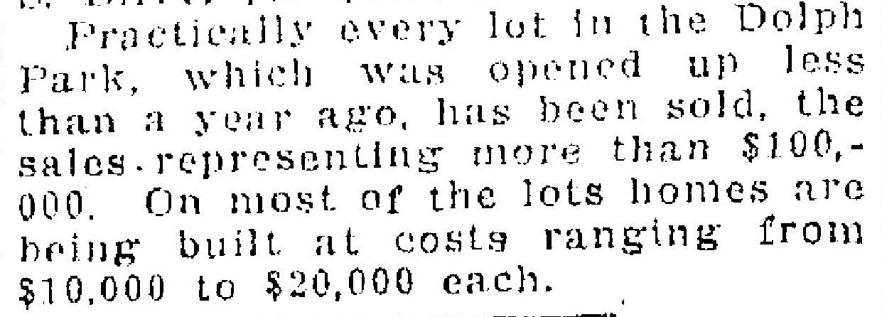
One year later, on September 19, 1926, the newspaper reported that almost every lot had been sold:
Like a pulse of work moving through the system, architects, owners and builders were busy making their plans and 1928 was a big year for construction in Dolph Park. This is from the Oregon Journal on February 3, 1929.
~ ~
Here’s an interesting way to look at it: a compilation we’ve built of four Sanborn Fire Insurance Company map plates (click below to enlarge) which provides a snapshot in time from 1924, just as the property was being formally platted. The recognizable grid of streets is present all around, but the future Dolph Park is still an unformed island in the middle of it all, showing several random houses, one large home near 33rd and Tillamook, and scattered green houses. Fernwood School is in the lower right. Eugene Street would later become part of today’s U.S. Grant Place. What other changes do you see?
The scaffolds and fences have come down from around the former First Universalist Church of Good Tidings / Metropolitan Community Church at NE 24th and Broadway, and soon the doors will open on the restored and repurposed 112-year-old church building.
The former First Universalist Church of Good Tidings was built in 1909 and has recently been restored and repurposed. It opens to the public soon. Photographed July 2021.
We wrote about the project here last November: neighborhood residents Brody Day and Dustin Harder have been adapting the old church into the new Steeplejack Brewing Company. The two acquired the building in April 2019 from the Metropolitan Community Church which was downsizing to a building in Southeast Portland following 42 years in the space. At the time, another offer was on the table from a local developer who wanted to demolish the church and build a five-story condominium on the site. After a meeting with the pastor and the congregation—and assurance that Harder and Day were planning to keep the building intact—they successfully closed the deal.
Steeplejack opens quietly to the public starting on Friday, July 23rd from 3:00-10:00 p.m. with a grand opening scheduled for Saturday, July 31st, when regular hours begin from 7:00 a.m.-10:00 p.m.
The old church has the distinction of being one of a few buildings in Portland dedicated by U.S. Presidents. William Howard Taft sealed up a small time capsule and set the cornerstone during the building’s opening on October 4, 1909. Day and Harder have the original box (it had been opened some years ago) and plan to set a new cornerstone, sealing in the old box, at 2:00 p.m. on Saturday, July 31st. Next week, they’ll be accepting very small time-travel items that might go into the box.
We had a chance to visit the newly-completed restoration as part of Steeplejack’s soft opening this week and offer these glimpses of the “new” old space:
The front door and location of the historic cornerstone and time capsule, which will be placed on Saturday. July 31 at 2:00 p.m. The original cornerstone was set by U.S. President William Howard Taft on October 4, 1909.The west face of the building. Note the heart shape in the large stained-glass window, and then have a look on the wall inside (below) as the sun shines through.An interior scene. Tables built with original structural wood reclaimed during the restoration.
We’ve learned tonight about the passing today at age 104 of beloved neighborhood author Beverly Cleary, whose stories about Klickitat Street, an adventurous girl named Ramona, and a bunch of creative kids bring our early neighborhood vividly to life. To celebrate her gifts, we’ve reprised below this post from 12 years ago. Thank you Beverly Cleary: your stories touched our own childhood, and connect us with our kids and with this place.
_________________
The Geography of Imagination: Exploring Neighborhood History With Henry, Ramona and Beezus
We’ve been re-reading some favorite books recently, and as it turns out, finding quite a few clues to the world of neighborhood history. Award winning children’s writer Beverly Cleary grew up in the neighborhood and if you read carefully, you’ll find real echoes of our past in her books.
Cleary imagined an entire universe in a few small blocks. Our favorite young residents—Ramona, Beezus, Henry, Ribsy—crisscrossed their kingdom on bikes and on foot walking to their beloved Glenwood School, delivering the evening Journal newspaper, and getting themselves into some memorable misadventures.
Ramona Rides downhill (is that Regents or maybe NE 37th?) in a drawing by Louis Darling.
The geography of that imagined place came from author Beverly Cleary’s own experience as a child growing up here in the 1920s and 1930s. She lived in a home on Northeast 37th Avenue, and attended the school now named for her: the Beverly Cleary School Fernwood Campus. The landmarks that define Henry and Ramona’s world—the churches, schools and houses, the hills and even the vacant lots—are drawn from places Cleary frequented as a young person.
It’s possible to find clues to Cleary’s own geography—and even a sense of Alameda neighborhood life in the 1950s—by exploring Henry and Ramona’s neighborhood as it unfolds on the pages of more than a dozen of her books.
A good place to begin looking for clues is Ramona Quimby’s house, just up the street from Henry Huggins on Klickitat Street. Cleary actually tells us in one of her books that Ramona lived with her mother, father and sister Beezus in a rented house near the corner of 28th and Klickitat. I remember reading that part of the story to my daughter one night and making a mental note that I needed to go look up that address on my next walk through the neighborhood.
As many astute readers will recognize, the corner of 28th and Klickitat is actually a “T” intersection adjacent to the playground at Alameda School. The day I walked past that spot and realized it was the setting for Ramona’s fictional house (a school playground), I laughed out loud and tipped my hat to Beverly Cleary.
All readers of the series know that Henry Huggins lives with his mother, his father and his dog Ribsy in a square white house on Klickitat Street. Cleary never really tells us exactly where on Klickitat that might be. But if it’s a square white house—let’s imagine an old Portland foursquare style house with a nice porch—chances are it’s west of Ramona’s house. In Henry And the Paper Route, Cleary hints that Henry’s square white house was slightly elevated above the sidewalk with a sloping lawn the kids rolled down. This sounds indeed like a four-square, built in the 19-teens. Now all we have to look for is Henry’s red bike and the barking Ribsy.
Ramona and Henry’s Glenwood School is an obvious stand in for Fernwood School (known today as Beverly Cleary School), where the young Cleary attended before moving on to Grant High School. Why didn’t she create a fictionalized role for Alameda School? We do know there was a certain rivalry between neighborhood schools. Kids from one school sometimes looked down their noses at kids from the other. Was omitting Alameda School a diss? Probably not. Just a little too complicated to explain why kids living in the playground of one school (wink) would be going to a different school a few blocks away.
Vacant lots…now there is a commodity of the 1950s that we just don’t have any more. By the late 1950s virtually every easily buildable lot in Alameda had been developed (many of the last ones by builder Ken Birkemeier). During Cleary’s growing up years—the 1920s and 1930s—there were plenty vacant lots to be found and they surely provided a refuge for everything from baseball to clubhouses. In Cleary’s 1955 Henry And the Paper Route, Henry watches as the ladies club sets up sawhorses and planks in a nearby vacant lot for the annual fundraising rummage sale. The vacant lot was a community commodity as well as landmark. Reading more closely between the lines, was the ladies club the fictional counterpart of our own Alameda Tuesday Club? Could be.
The business district of the fictional neighborhood bears some resemblance to places we all shop and frequent today. The movie theater, dime store, Rose City Barber Shop and even the “Colossal Market” are landmarks in today’s Hollywood neighborhood. The Colossal—where Henry’s mother bought everything from vegetables to hair clippers—was probably patterned after the original Fred Meyer store at 42nd and Sandy.
Al’s Thrifty Service Station, where Ribsy steals a policeman’s lunch, is today’s 76 station at 33rd and Broadway. Kids at Glenwood School watch from their classroom windows as a new supermarket is built: today’s QFC (formerly Kienows) just south of Fernwood. All the pieces line up.
In addition to the fun of hearing about these thinly disguised places we all know from our area’s past, there’s some wonderful imagery in these books that evokes an earlier time in the neighborhood, while also being timeless:
Ramona and Beezus playing outside on a summer’s evening until the street lights come on, when it’s time to go in.
The 11-year-old Henry riding his bicycle through the neighborhood in the late afternoon and early evening, delivering the afternoon newspapers hot off the press.
Kids jumping in puddles and playing in rivulets of muddy water on a rainy morning’s walk to school.
The Fuller Brush man in trenchcoat walking door-to-door selling his wares.
Henry crawling on all fours through Grant Park at night with flashlight in search of nightcrawlers for fishing.
And a timeless image that could have been borrowed from this winter: Ramona sledding down the 37th Street hill on her dad’s old sled. Now there’s a scene drawn from the author’s personal experience, just a few doors up from her own childhood home.
Which gets to what makes Beverly Cleary’s work so appealing and enduring (and even instructive, for us students of history who also like to read to our kids): she crafts a slice of universal life through the experiences of her likeable, believable characters, and all through the lens of a remembered Northeast Portland childhood.
Most posts here on AH focus on the period between 1890-1950 and are directly related to the development and early life of neighborhoods and their residential and commercial buildings. So much happened during those years to shape Portland’s eastside landscape. Much has happened since that time.
But our time here pales compared to the time before.
I’ve been on an exploration this winter to understand more fully and appreciate the deeper history of this landscape we think we know. And it’s changed the way I think about this place.
For thousands of years—since time immemorial—there were people here on these lands and nearby waters in extended communities and families, living within the seasonal round of the year: movements of fish, deer and elk; the growth and availability of plants for food and medicine; the season to put fire on the land to manage for future food sources.
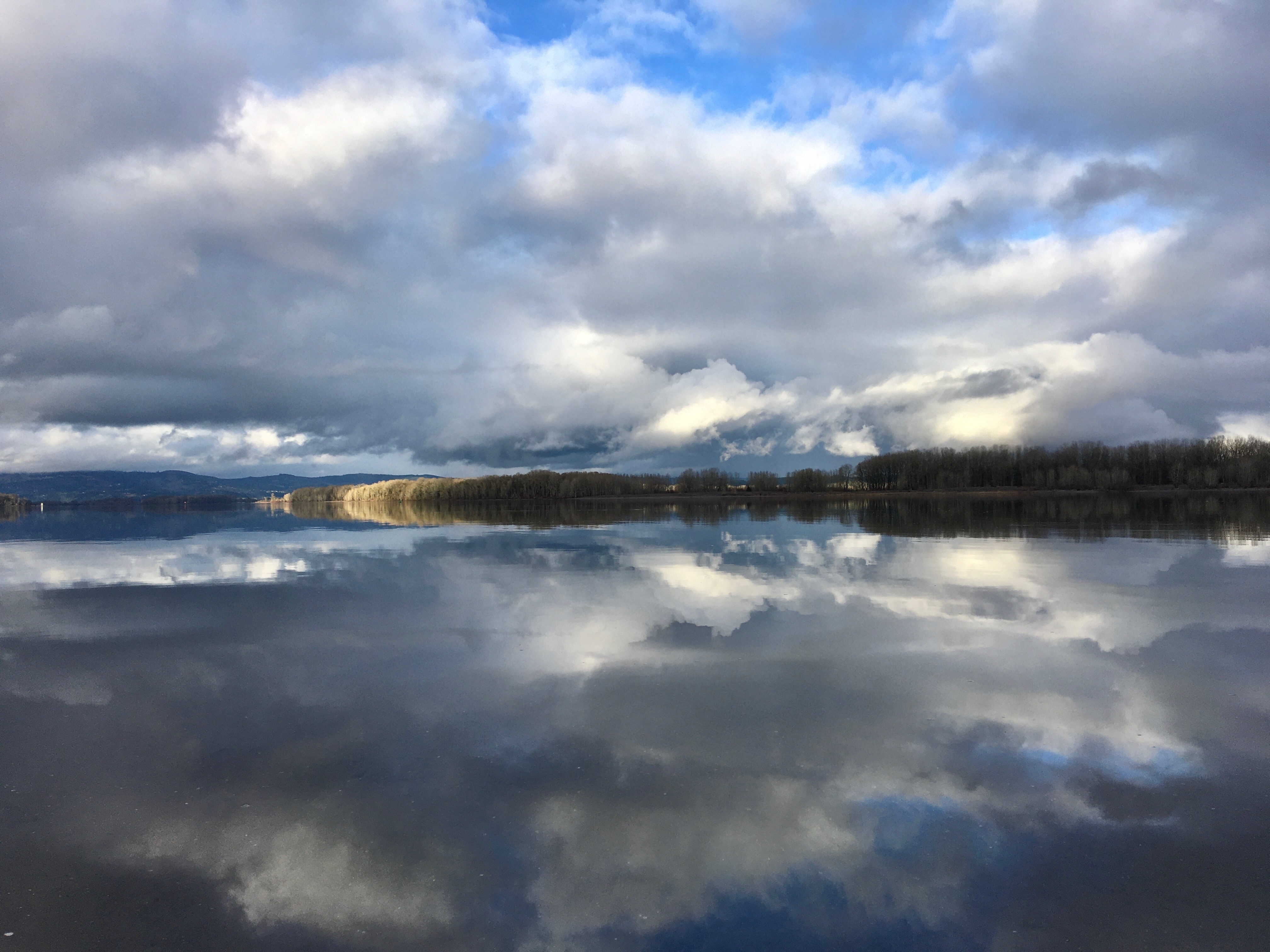
The Columbia River near Warrior Point, February 2021. Doug Decker photo.
The Columbia River—which is probably out of mind on a day-to-day basis for most neighborhood residents today even though it flows less than two miles from our doors—was the source and backbone that made life possible for the families who lived all along its banks, from the mouth at the Pacific Ocean near Astoria, to far upriver.
Here in what is known as the Portland basin, the Chinookan people of the lower and upper Columbia met and traded with tribes arriving from the Willamette River and its tributaries, by land over the Coast Range, and from the tributaries to the north and east that drain today’s southwest Washington.
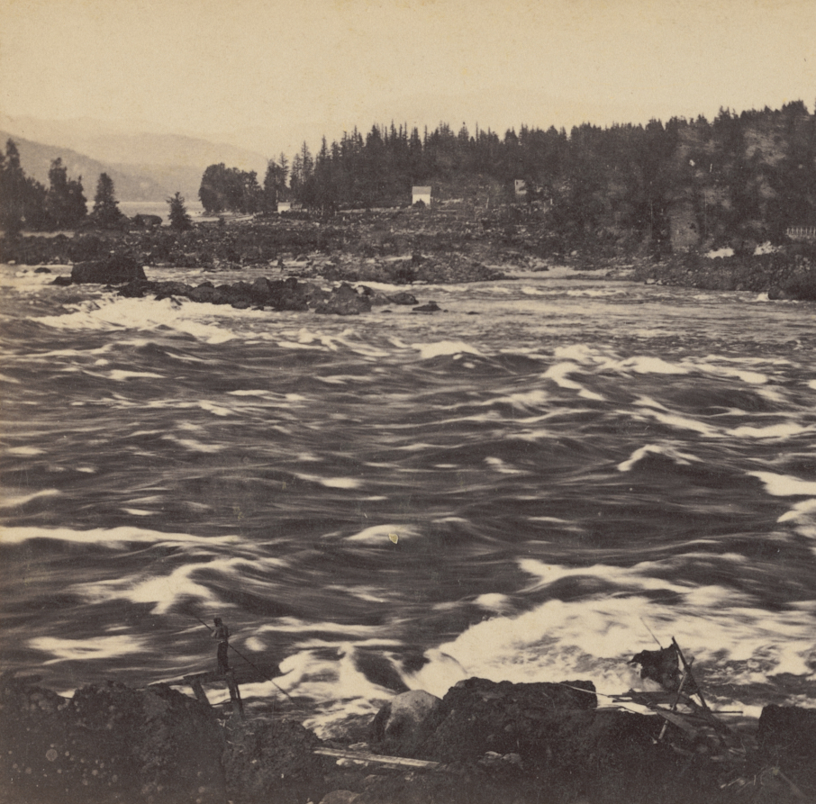
When the salmon were running, people were drawn upstream to the Cascades of the Columbia: impressive cataracts and fishing grounds in the vicinity of today’s Cascade Locks that disappeared with the advent of Bonneville Dam in 1938.
Salmon Fishing in the Cascades, Columbia River, 1867 by Carlton E. Watkins. Note man with dip net standing on scaffolding at river’s edge. Photo taken from the Washington side looking southeast toward current-day Cascade Locks. Courtesy of the Oregon Historical Society, OrgLot 93_B1_133r
After the fish runs and at different times of year, many of the people traveled downriver into the rich waters of the Portland basin. Food sources, family ties, language, traditions, and shared experience in known places made these people at home here at certain times of the year, and at home upriver at other times. This was their home for 10,000 years (our neighborhoods were platted 115 years ago).
Prior to contact with Europeans, the Portland basin likely held the greatest concentration of indigenous people in the region. Estimates suggest as many as 10,000 people lived in 29 villages stretching from the Sandy River Delta on the east to the confluence with the Lewis River on the west, a distance of about 34 river miles.
People were here because this stretch of the Columbia River that passes along our northern edge was unbelievably rich. The braided channels, ponds, islands and backwaters of what was referred to as the Columbia Bayou—today’s Columbia Slough—harbored and produced an amazing variety of plants, fish and wildlife. These were a canoe people, and these waters meant life. The Portland basin was principally a canoe place.
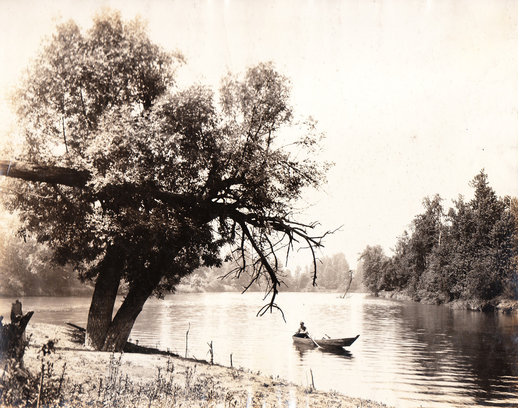
Fishing in the Columbia Slough, early 1900s.
When Lewis and Clark and the Corps of Discovery passed downriver in early November 1805 and returned upriver in March 1806, they witnessed and reported on the diversity of indigenous people and languages here, and the richness of the river and upland environments. Of particular note to them was the potato-like aquatic tuber known as wapato, which was a staple food. Wapato grew in abundance in this 34-mile stretch and attracted people from across the region.
Because of its prominence in these waterways and in peoples’ lives, Lewis and Clark referred to this reach of river as the Wappato Valley.
The fur trade that boomed after Lewis and Clark’s early explorations brought disease. A malaria epidemic in the early 1830s devastated the people in these villages, killing 90 percent of the entire population. Waves of Euro-Americans began arriving from the east in the 1840s and the few remaining indigenous people were removed from the places they knew. Their lands were taken through a variety of means and distributed among the new arrivals, who set the landscape on a pathway into farming, resource removal and eventually development to house the rapidly growing population of newcomers.
Their lands became our neighborhoods. And their 10,000 years disappeared from view.
Which is why it’s so important for us to learn and to help remember.
The tragedy and rupture of how the indigenous way of life ended reverberates today. The descendants of these people remain and have dedicated themselves to remembering their ancestors, their language and ways of living they knew, and their lands and waters.
The more I’ve learned about this stretch of river, the more I’ve come to think differently about Portland’s northern edge, about Sauvie Island, the Multnomah Channel, the Columbia Slough, Broughton Beach and the stretch of shore near the airport and Blue Lake, and Cathlepotle, a bit farther downriver. These were busy places. Dramatically changed from their earlier forms, they persist nonetheless.
Less than two miles from my house, along the braided waterways of the Columbia Bayou, was Ne-er-cho-ki-oo, A Chinook village and plankhouse home to generations of families living in that seasonal round of upriver fishing at the Cascades and wapato gathering here in the valley. The waters they knew have been altered beyond recognition. But learning the story of that place, being able to look back at historic maps of the Columbia Bayou and imagine that landscape, are all part of remembering.
Here’s a thought exercise for you the next time you travel north on any of the main thoroughfares that intersect where Portland meets the Columbia River. As you begin to descend toward Columbia Boulevard (or Sandy Boulevard east of I-205), recognize that you are transitioning out of what were wooded uplands into what was the swampy, marshy storehouse of life along the river. Water’s edge didn’t stay mostly in one place as we know it today, it ebbed and flowed with the river and the season. The Columbia Slough we know today was alive with people: women and their canoes gathering wapato; men hunting and gathering fish. Watch for those waters and think about that as you zip across a bridge.
Columbia Slough, 1905. By Lily E. White. Courtesy of Oregon Historical Society Org.Lot 662, Folder 1, Plate 4.
Next time you visit Sauvie Island, think of the many villages there—home to an estimated 2,000 people—that were important centers of trade. Following the malaria epidemics of the 1830s which killed the vast majority of those people, employees of the nearby Hudson Bay Company post at Fort Vancouver burned the remains of the emptied villages and turned the island into a dairy.
Consider a 30-minute drive north to Ridgefield to visit the Cathlapotle long house and the refuge trails which bring into focus how the river connected people with villages and resources on Sauvie Island just across the water, with tributaries and other villages all up and down the river and beyond.
These days whenever I’m out and about, I still “see” the old streetcars, the muddy roads, vacant lots and the builders we’ve met here on AH, busy building these neighborhoods in the early 1900s.
But there’s a much deeper landscape we can orient to that contains it all, defined by rivers and the generations of people who have come before.
A few recommended sources for learning:
Chinookan Peoples of the Lower Columbia, edited by Robert Boyd, Kenneth Ames and Tony A. Johnson, University of Washington Press, 2013.
Cathlapotle and its Inhabitants, 1792-1860, by Robert Boyd, US Fish and Wildlife Service, 2011.
The Coming of the Spirit of Pestilence, by Robert Boyd, University of Washington Press, 1999
We’ve been focused lately on a property in Southeast Portland’s Woodstock neighborhood, which has provided some fresh perspectives on aspects of Portland history we haven’t bumped into directly while working in the central eastside. Things like the dynamics of annexation, lots of different privately-owned infrastructure, and multiple waves of readdressing.
AH readers already know all about the major readdressing initiative in the early 1930s that literally re-made the Portland map. The Great Renumbering clarified things for most Portlanders (particularly postal employees), but not everyone was thrilled. One feature of the readdressing ordinance required all north-south streets be numbered, not named. That’s how we lost Glenn, Marguerite, Vernon and others, though the names can still be seen set into many curbs.
We’ve always been impressed with the residents of NE Vernon Avenue who continued to use the name of their street for more than a decade after the city changed it officially to NE 14th Place. Many living on that six-block stretch between Prescott and Killingsworth didn’t want to lose their local identity and continued to tell the world they lived on NE Vernon well into the 1940s. Place names are important, after all.
But we digress. Out in Woodstock, some of their streets have known three different names:
The one that came with the plat, and in Woodstock they all had names out of Sir Walter Scott’s romance fiction set in 17th Century Oxfordshire (Waverly, Kenilworth, Ivanhoe, Everard, Wildrake);
Those that came after Woodstock’s annexation in 1909, which randomly replaced some of the Oxfordshire repertoire and turned all the east-west streets to numbers (yes, you read that right…we’ll come back to this with a map in a moment);
And then the ones that came along as a result of the wider readdressing wave of the early 1930s.
We were delving into a property on today’s SE Ramona, which started out as High Street on the 1889 plat, became 58th Avenue Southeast by 1915, and then became the Ramona we know in 1932.
Today, most Portlanders take their numbered north-south streets for granted and can quickly orient themselves to the Willamette knowing that on NE 24th Avenue they are 24 blocks east of the river (plus or minus).
But by 1915, all of southeast Portland’s east-west streets south of Division were assigned numbers as names and called “avenues,” counting south from Ankeny (north-south roads were called “streets”). Also of note, most of the east-west streets north of Division stuck with their names because they had an established named counterpart on the west side of the river.
So today’s SE Ramona was Fifty-eighth Avenue Southeast (that was the nomenclature, with the ordinal direction written out at the end of the phrase).
Confused?
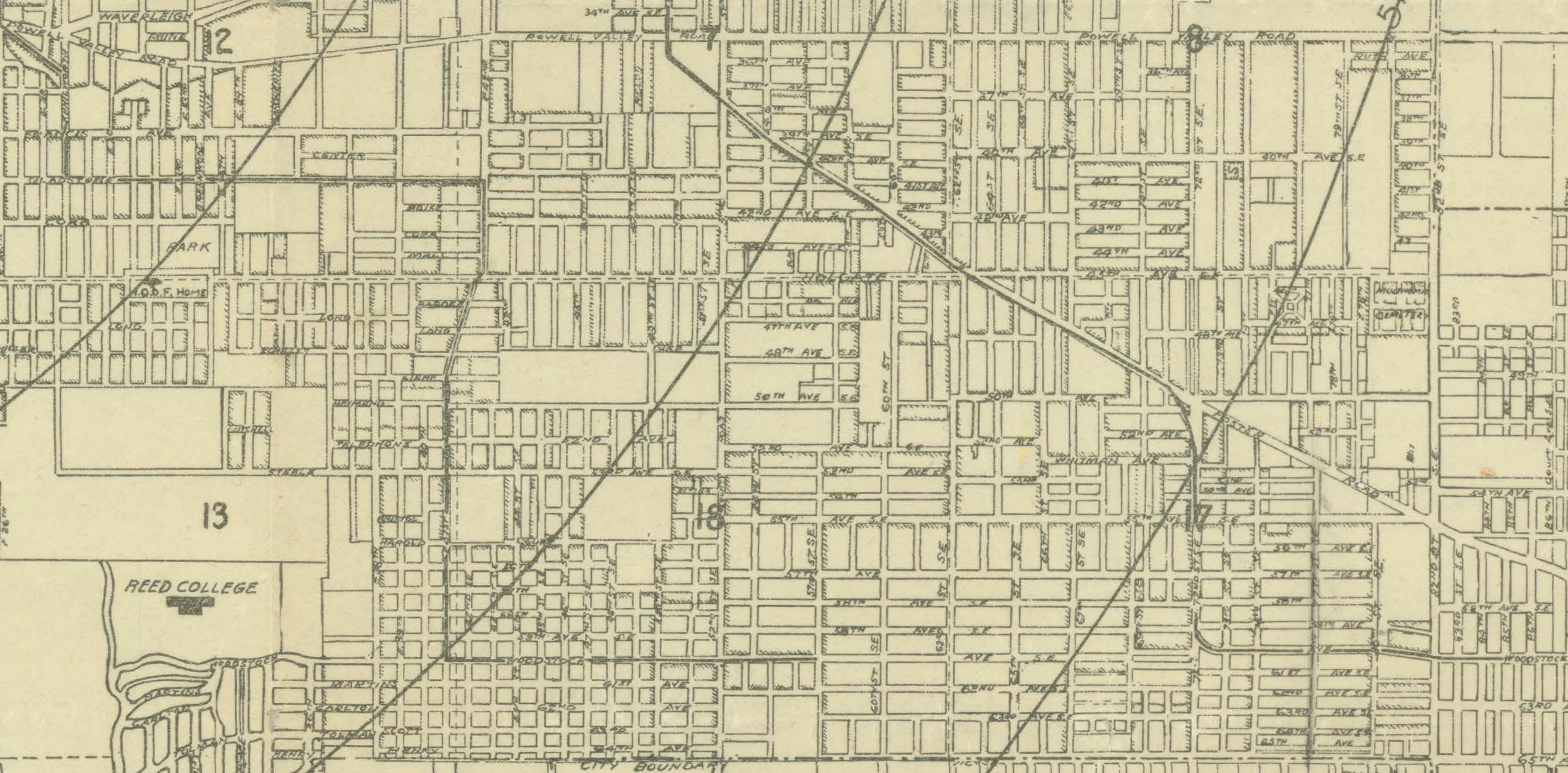
Here, have a look at the 1915 Pittmon’s Guide map to Portland. We’ve detailed a chunk of Southeast that illustrates this east-west avenue phenomenon.
1915 Pittmon’s Guide to Portland, detail showing SE Portland from Powell Valley Road to Duke. Click to enlarge.
Just when folks were getting used to the New York-style of numbered streets and avenues, the Great Renumbering came along and put an end to all of that. Readdressing took place through several city ordinances passed over time in the early 1930s, each one cleaning up a few details missed from the last one.
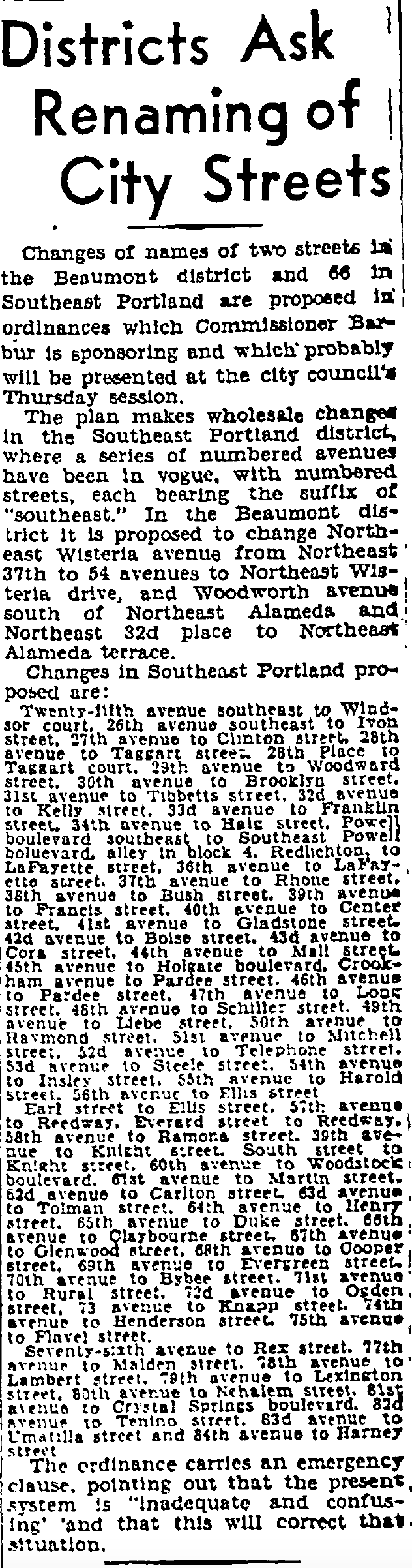
Here’s a story from the Oregon Journal in 1932: take note there were 66 changes to be made in southeast Portland, but Alameda and Beaumont had some clean up to do as well. It’s an interesting idea that addressing systems could be in vogue or out of vogue.
From the Daily Oregon Journal, December 11, 1932.
That’s a little piece of Portland’s addressing history we didn’t know before our deep dive in the southeast: east-west avenues with the directional at the end of the address once gridded that part of town.
We’ll save other insights for future posts:
How before annexation a myriad of privately-owned water systems were elbowing each other for business and access to Bull Run water (Woodstock was on a private well for many years).
Same for Portland’s streetcar system, which really wasn’t a single system but a collection of competing fiefdoms for many years until consolidation began in 1904.
And annexation, those neighborhood politics were as polarized as possible: some public meetings devolved into shouting matches, the rhetoric related to taxes and the role of government. In Woodstock, even after the November 1908 61-percent victory for annexation, the anti-annexers challenged the vote all the way to the Oregon Supreme Court where it was affirmed and Woodstock became part of Portland on July 1, 1909.
2-13-2021 Post Script: We’ve posted a link to the full 1915 Pittmon map, which is now on our Maps page. Embedded in that map is a statement that highlights the challenges presented by the pre-1930s address system. This official map advice relates to getting around in North Portland:
Extreme care must be exercised in this district as the streets having E. and W. prefixes are more nearly north and south. While streets having “N” and “S” prefixes are more nearly east and west.


