It’s been a busy winter preparing history studies for properties all over Portland, working on the historic newspaper project and some other deep dives, and making presentations on local history topics. It’s what we love to do, so we’re happily busy. But all that work has borrowed time from the blog, which has been on the quiet side lately.
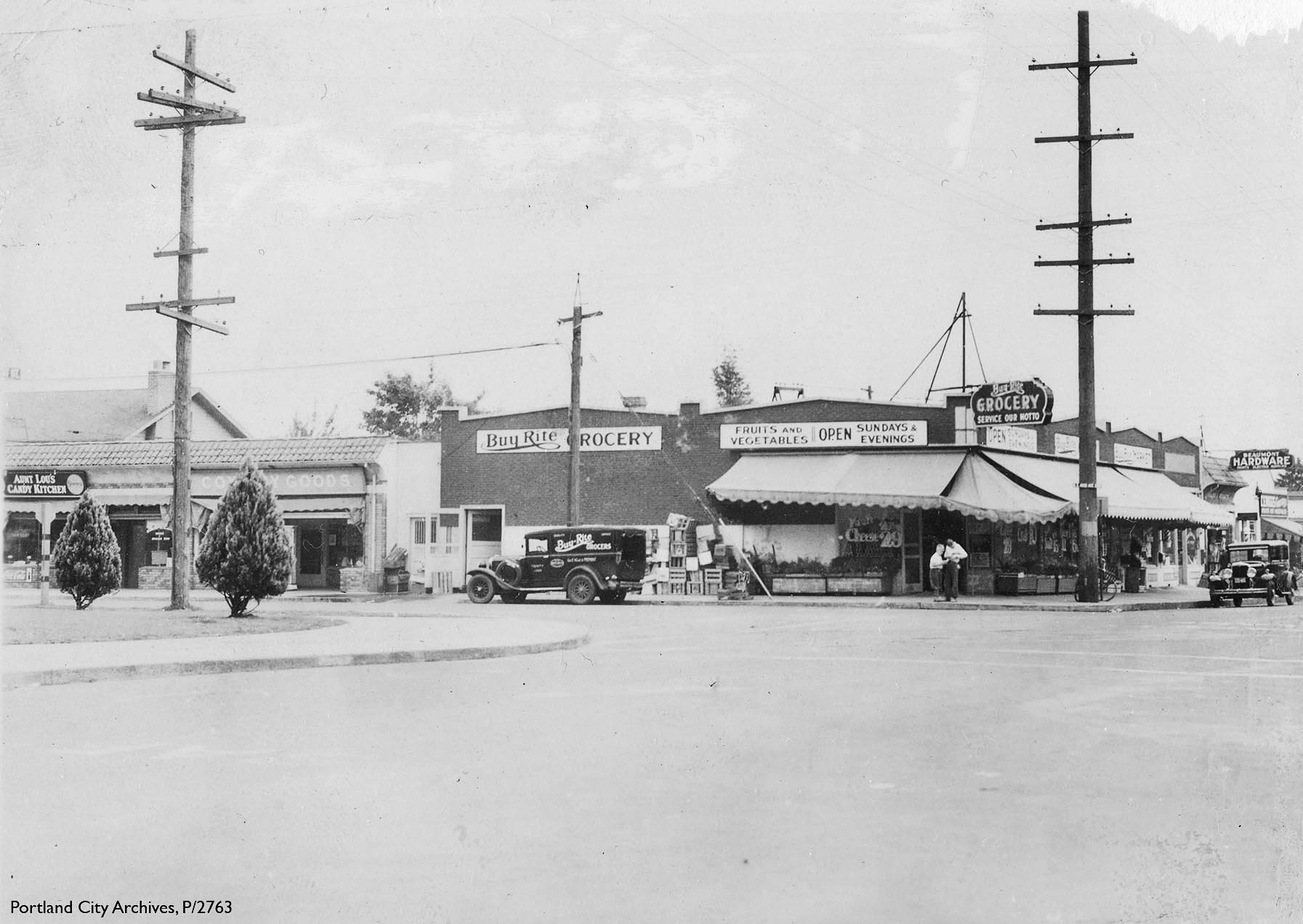
Let’s break the quiet with an interesting photograph related to other photos and stories we’ve shared here. Check it out: NE 42nd and Fremont in the Beaumont neighborhood, on Thursday, July 27th, 1933. Click in for a good look and then we’ll discuss.
July 27, 1933, NE 42nd and Fremont. Courtesy of Portland City Archives P/2763
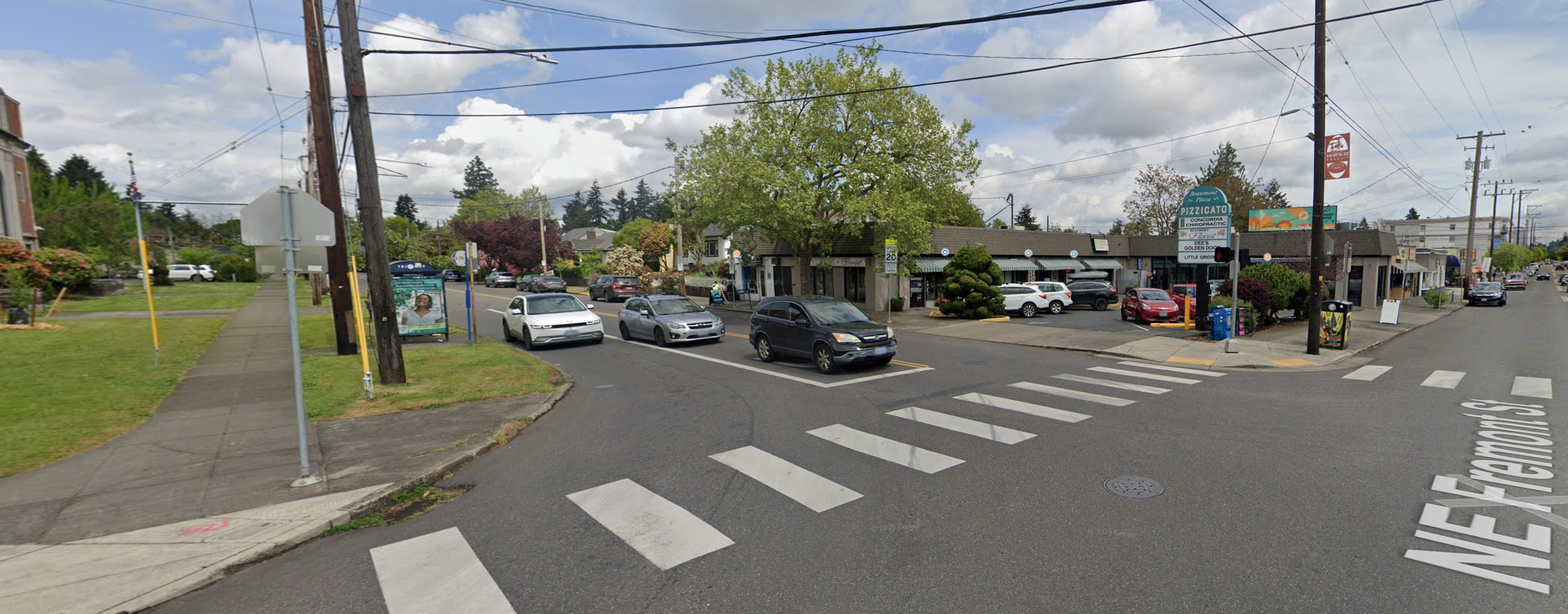
First things first: the view is looking to the east-northeast from Fremont Street showing the northeast corner of the intersection with NE 42nd Avenue. Below is a contemporary photo that will help you place this view (note the corner of Beaumont School in the far left):
Google Streetview – April 2025
Let’s take inventory of the 1933 buildings and businesses we see in that old photo, working left to right:
Aunt Lou’s Candy Kitchen, a candy store, perfectly situated across the street from Beaumont School. Today, the space is occupied by Little Griddle, 3520 NE 42nd Avenue. Aunt Lou’s was owned and operated by Lou and Jesse Opdyke, who also owned candy stores downtown and at SE 36th and Division. The storefront just to the south was vacant in July 1933, but had been Alameda Shade Shop, a maker of light shades.
Cox’s Dry Goods, run by Horace Cox in a portion of the space that up until recently was occupied by Beaumont Florist, 3512 NE 42nd Avenue. The rest of that building no longer exists.
Buy Rite Grocery, 4201 NE Fremont, occupied the entire northeast corner of the intersection facing both 42nd and Fremont. Much of the footprint of this building today is a parking lot serving Beaumont Plaza which contains the former florist space, a chiropractor, a hair salon and Pizzicato.
Owned and operated by Henry Witt, Buy Rite was the first grocery in the neighborhood, pre-dating the Beaumont Market by about 10 years, and it was the anchor Beaumont business. Back in 1933, Henry Witt and Buy Rite wanted to make sure you knew they are open for business on Sundays and evenings, and that service is their motto. The two boys out front appear to be focused on a recent purchase. The store’s delivery bike leans up against the power pole, which looks to occupy the same place on the sidewalk as it did way back when. The delivery truck ready at the curb.
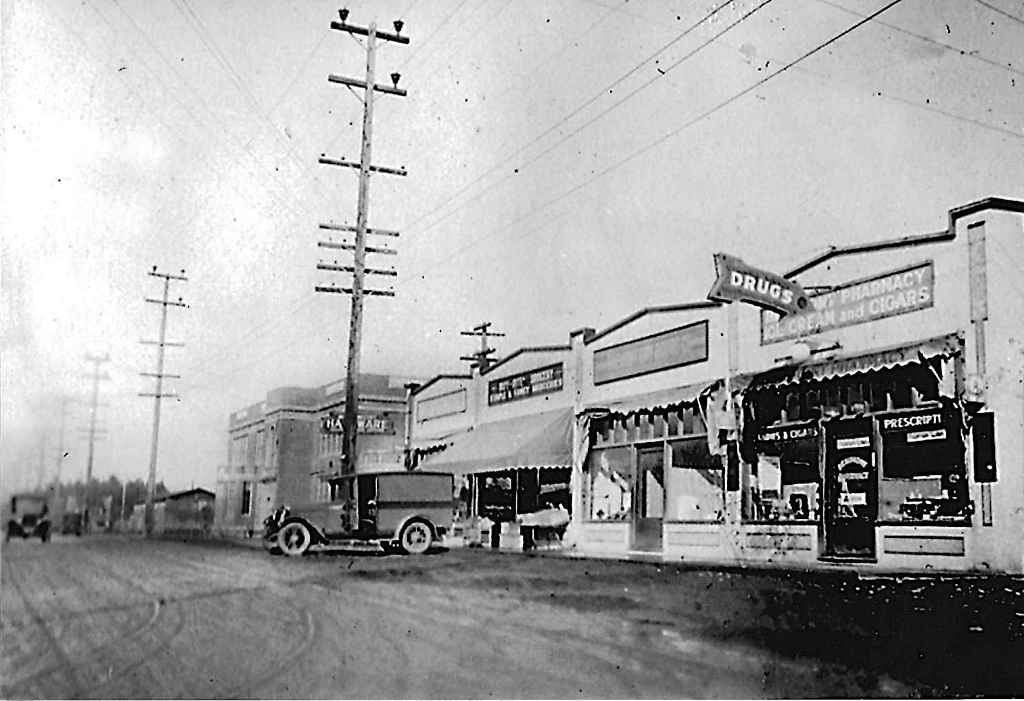
Here’s what the Fremont side of Buy Rite looked like in a 1927 photograph shared by former Beaumont neighbor Paul Kirkland, looking west-northwest (yes, that’s the brand-new Beaumont School in the distance). Sure looks like the same delivery truck parked out front. Streets haven’t been paved yet:
You can read more about the 1927 Beaumont photos and memories Paul shared with us back in 2015.
Back to our 1933 photo: A bit farther east on Fremont you can see the sign for the original Beaumont Hardware, which in 1933 was at 4217 NE Fremont, about a half block west from the Beaumont Hardware we know today.
When you really stare at this photo and think about it, certain questions come to mind. Like: what were you supposed to do as a driver when you approached? Our hunch is that NE 42nd had the right-of-way, so if headed north or south, you just swung through the jig-jog there. In the contemporary view you can see how the signals and their wiring dominate the intersection today. Of interest: in the 1933 photo, the streets had only relatively recently been paved.
If old views of this intersection look vaguely familiar, it’s because we’ve written about them before and shared photos and insights about Beaumont market across the street.
Want to read more about Beaumont-Wilshire? Here’s a category of more than 30 B-W posts we’ve written going back to 2007. Check it out. By the way, categories are a great way to find your way around the more than 350 posts and pages here on the blog: you can find the drag-down menu on the far right side of the page below the Top 30 list. One of our favorite categories: Photo detective.
Coming soon:A batch of new/old photos help us visualize the watery world of Bundy’s Baths on the east bank of the Willamette River near the northern tip of Ross Island.
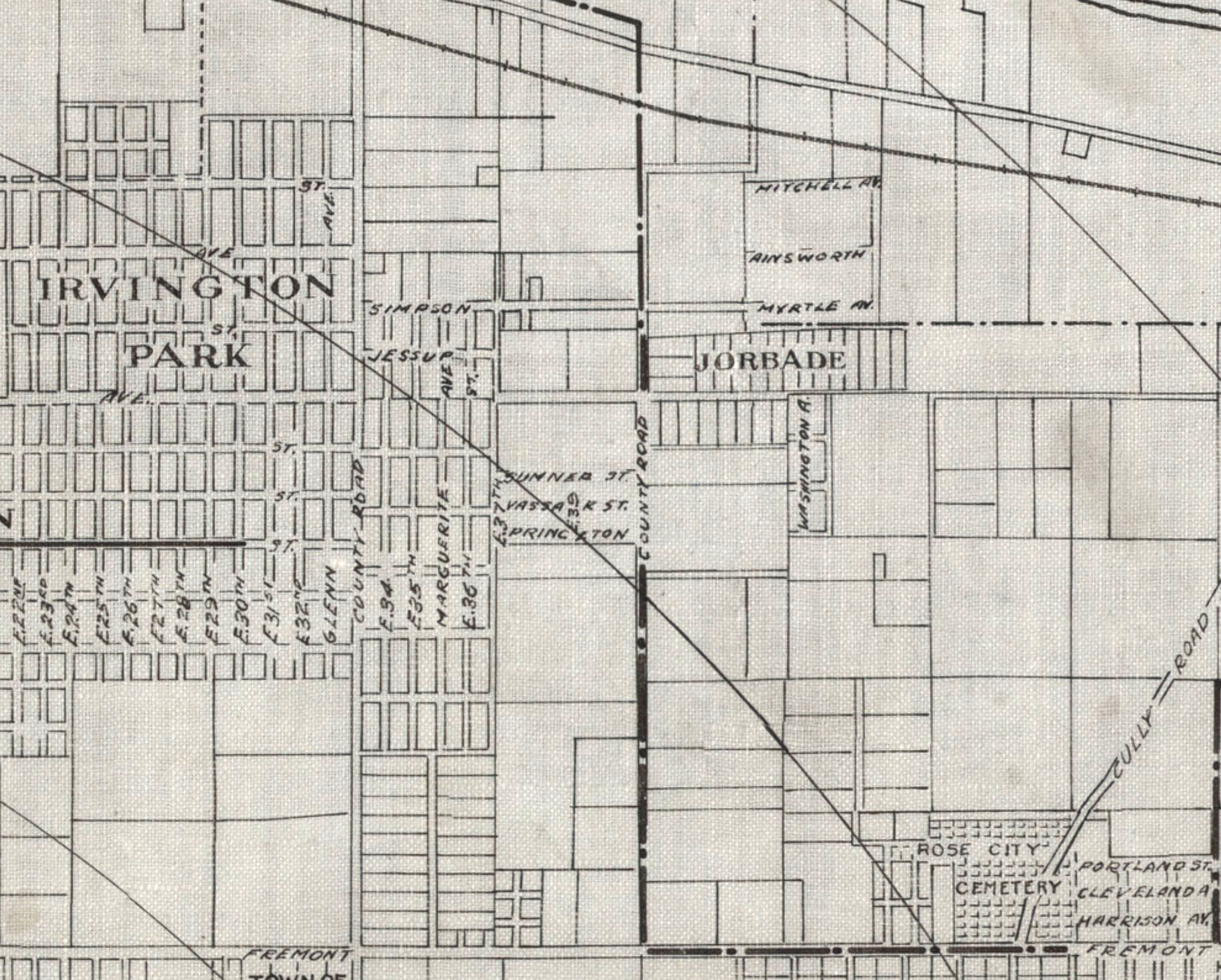
Detail from a 1908 Portland Railway, Light and Power Map showing the vicinity of 42nd and Killingsworth, in the center of the image. The Jorbade subdivision was platted at the intersection in 1908. The western “County Road” is today’s NE 33rd. The eastern “County Road” is NE 42nd. Rose City Cemetery appears in lower right (note that Cully passes through the cemetery).The cross-hatch lines indicate mile increments distant from downtown.TheIrvington Park plat is part of today’s Concordia neighborhood.The Alameda Park Addition had not yet been platted and is shown as open fields.
Continuing from our first installment exploring the layers of history at NE 42nd and Killingsworth…
The early years of the 20th Century brought a sea change to the Portland area: dramatic growth in population and a spike in residential and commercial construction that followed; a steady increase in the area’s rail and river shipping and port activity; extension of an interconnected electrified streetcar system; and arrival of the automobile. The 1905 Lewis and Clark Centennial Exposition drew national and international attention to Portland, attracted business and new residents, and set Portland on a growth curve that would remake the region.
During those early years, the vicinity of NE 42nd and Killingsworth was still a rural crossroads. Killingsworth (which was gravel) didn’t go farther east: it dead-ended into NE 42nd Avenue, which was known only as “County Road” up until the late 19-teens. Maps show the area much like the 1897 USGS map until the second decade: fields all around and less than 30 buildings—many of them barns—within a one-mile radius of the intersection.
But real estate speculators and some landowners could see the writing on the wall. Streetcar lines were working their way east, and new subdivisions and commercial areas were being planned and built. By 1912, a high volume of residential construction was underway in nearby Alameda, Beaumont and Rose City, all of which had been similar open fields and dirt roads.
Open lands are platted for homes, setting the stage for the area we know today
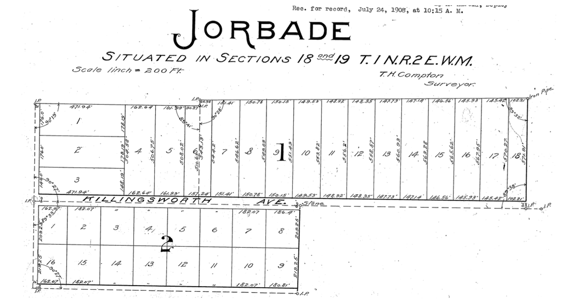
By 1909, real estate speculators Commodore Perry Jordan and Theodore August Garbade had purchased a portion of the old Isaac and MaryAnn Rennison Donation Land Claim at the intersection of today’s NE 42nd and Killingsworth. The two planned to sell residential building lots from what had been open farm land. Jordan and Garbade called their planned suburb “Jorbade,” and filed this plat with Multnomah County. The western edge of the plat is NE 42nd Avenue. Important to note that Killingsworth wouldn’t go through for at least 10 more years. These lots would be just that–vacant lots–for many more years.
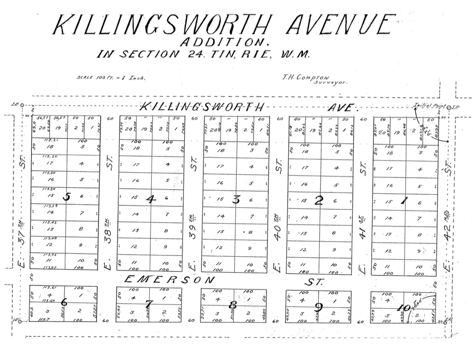
A few years later Jordan and Garbade acquired the lands on the opposite corner and were ready to convert them too from open fields to a subdivision. In 1911 they platted the Killingsworth Avenue Addition, from Killingsworth south beyond Emerson, between NE 37th and NE 42nd.
A bit farther west, local resident and real estate speculator John D. Kennedy was a few steps ahead of Jordan and Garbade. He had bought old homestead lands in 1880 believing that Portland would one day expand east; in 1890 he platted the Kennedy Addition, while this area was still part of its own town: East Portland. Here’s a detailed look at Kennedy and his adjacent nearby lands.
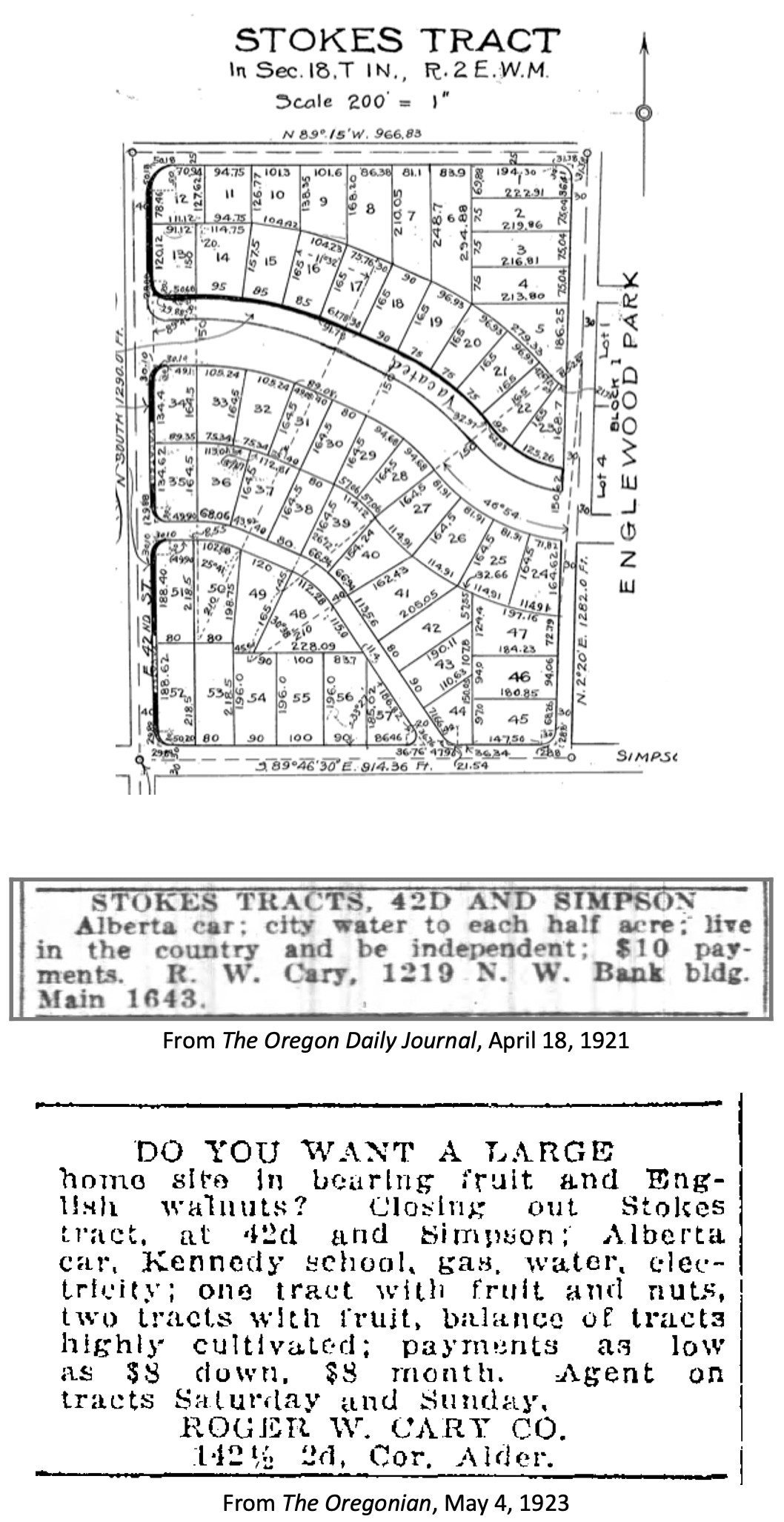
The Stokes Tract followed Jorbade and the Killingsworth Addition in 1920, north of Killingsworth and east of 42nd, establishing the graceful arc of Ainsworth and Simpson Court. This area retained a rural feel: “Live in the country and be independent” reads the advertisement.
Other subdivisions followed including tiny View Park in 1923, on the north side of Killingsworth between 36th and 40th:
Interest in these planned subdivisions was not particularly strong until the late 1930s: their distance from downtown, their presence outside the city limits and about a mile walk from the nearest streetcar line (despite what the advertisement said about being on a 5 cent fare line); their rural nature including gravel roads and surrounding fields and orchards may have made them less attractive, even if the prices were lower. But as Portland continued to expand, and the automobile became more prevalent, would-be homeowners were ready to buy and build.
Classified advertisements for properties adjacent to the intersection report a variety of crops growing at the time: orchards of Bing, Lambert and Royal Anne cherries; English walnuts; Bartlett pears; prunes and plums; apples; rows of strawberries and raspberries.
Often referred to as “truck farms” because the produce was trucked to market (and some of it was sold out of the back of trucks at busy intersections and small markets around town), these surrounding fields produced fruit and vegetables for Portland households. One farm near the corner of what is today’s NE 41st and Holman was owned and run by a Japanese immigrant family, as were others in the area. During WWII, Japanese farming families across the Pacific Northwest were removed from their land and placed in internment camps in southeast Oregon, central California, Idaho, Utah, Wyoming and Colorado.
Portland Air Base leads to new roads and new residents
By 1935 air freight and airline passenger traffic had overwhelmed Portland’s first airport—located on Swan Island—and the city spent $300,000 to purchase a 700-acre site adjacent to the Columbia River where today’s Portland International Airport resides. With a grant from the Works Progress Administration, workers drained the former floodplain and dumped more than 4 million cubic yards of sand across the site. The airport opened in 1941. During the hundreds of generations of indigenous presence prior to European contact, these wetlands had been both seasonal home and food source.
Following declaration of war in late 1941, Army Air Base operations at the site were dramatically increased and Portland became a regional magnet, attracting tens of thousands of workers and their families to multiple war-related industries across the Portland area. An immediate demand for housing, combined with a newly-improved road network and the availability of open land in this area so close to the airbase, fueled interest.
A small expression of the interest was a long row of connected cabins dubbed the “tourist cabins” and an adjacent business called the Spur Tavern at the northeast corner of NE Holman and 42nd avenue. Built in 1942 as temporary housing for the great influx of people, the residences and tavern became a landmark of sorts. Read more about the Tourist Cabins and the Spur.
City buys old farms to create Fernhill Park
After voters approved a property tax levy in 1938 to create more parks and playgrounds for a growing Portland, the city set out on a 10-year process of buying the hills and gullies northwest of 42nd and Killingsworth, starting out in 1940 with a 10-acre parcel owned by the Jackson family right in the middle of it all.
Prior to acquisition, several dirt roads criss-crossed the north side of the area, one even ran right up the bottom of the gully at the heart of today’s off-leash area in the northeast corner of the park, pausing at a wide spot that served as a dump and debris field where car bodies and all manner of junk were strewn.
It wasn’t an official dump, but more like a secluded out-of-the-way place where residents from the surrounding area dumped unwanted items. In the late 1930s and early 1940s, when the NE 42nd Avenue connection to Columbia Boulevard was built, some of the dirt fill needed to make the grade change for the overpass was dug out from and supplied by the gully on the east side of the park along today’s NE 41st Avenue.
As the park took shape through the late 1940s and early 1950s, some locals referred to it as Ainsworth Park, a name that appears frequently in real estate advertising of that era. By the early 1950s, most of the open land to the north of the park had been converted to subdivision (the Vanlaeken and Leitritz plats). NE Highland Street was put through the middle of working farmland as the area was transformed into suburbia. By June of 1951 when most of the park buying was done, the city had invested $60,479 total for all of the parcels and had acquired 25.95 acres. Read more about the origin of Fernhill Park.
Aerial photographs = time travel
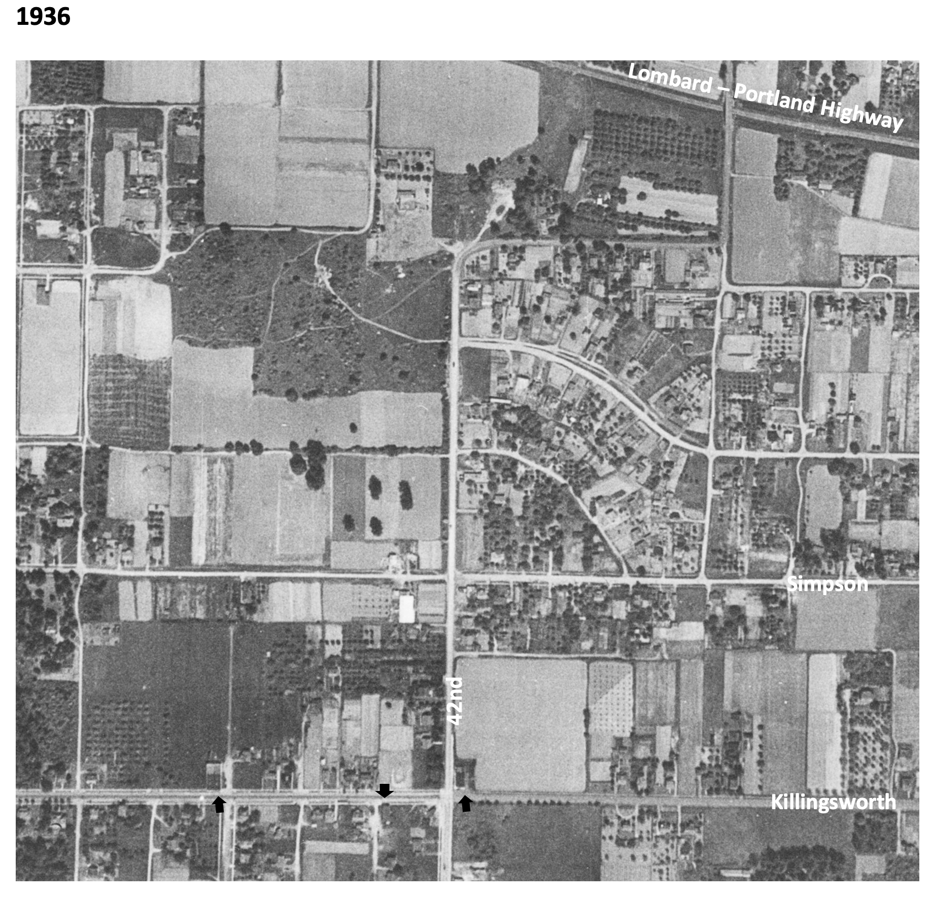
As a reward for reading this far, and as preface for the next installment, here’s a series of aerial photos that allow us to witness change. Each of these is fascinating, so click in for a detailed view. Observations follow each image. Aerial photoscourtesy of the University of Oregon Map and Aerial Photography Library.
In 1936, the unplowed lowlands of today’s Fernhill Park show up just left of center, and the arc of Simpson Court and NE Ainsworth feed into NE 42nd. No viaduct yet over Portland Highway. The arrows indicate locations of three small mom-and-pop groceries. Note that Simpson goes through east-west, across the middle of today’s Fernhill Park.
In 1939, more houses are showing up, and orchards in the center of the photo are maturing.
In 1948, the 42nd Avenue viaduct is in place (not pictured) connecting NE 42nd to the new Portland Airport. Houses continue to replace open fields. The greenhouses at Knapps Nursery appear west of NE 42nd at Simpson.Orchards near NE 37th and Killingsworth are replaced by homes.
In 1951, a trailer park appears at the NE corner of 42nd and Killingsworth in what were once open fields. Significant new home construction is evident north of Killingsworth and west of 42nd. The flat playing field at the south end of Fernhill Park begins to emerge from the former agricultural fields north of Simpson, and west of 42nd.Construction is underway on the new St. Charles Churchand school.
In 1961, the trailer park is replaced by a large Safeway store and parking lot at the corner of 42nd and Killingsworth, which opened in 1957. A baseball diamond is clearly visible in the new Fernhill Park. Orchards and open agricultural fields are gone.Simpson still goes through west of Killingsworth.South of Simpson in this area, 26 homes, three duplexes, a PGE power substation, and Knapp’s greenhouses and nursery are soon to be demolished or moved–over the strenuous objection of neighbors–to make way for John Adams High School.
In 1971, John Adams High School is in place, replacing a portion of the open areas of Fernhill Park and most of the homes between Killingsworth and Simpson west of 42nd. Simpson no longer goes through west of 42nd. Acres of parking are available west of the Safeway storeat 42nd and Killingsworth.
By 2020, John Adams High School (later known as Whitaker Middle School) was demolished in 2006, but the track remains. Neighborhood street tree canopies are filling out.Safeway is closed and the buildings at the northeast corner of 42nd and Killingsworth are now gone.
The intersection of NE 42nd and Killingsworth can feel like it exists on the way to somewhere else. But this crossroads has its own rich history that runs deep.
NE 42nd and Killingsworth, looking northeast. Fall 2023, Google streetview.
It’s worth slowing down time a bit to be able to see and explore the chapters here, which run back through commercial retail and early neighborhood development to wide open fields of berries and orchards, further back through the homestead era and even down slope toward the Columbia River and the slough wetlands that have been known and inhabited by Chinookan people since time immemorial.
This is the first of a three-part exploration to spark your imagination about the layers of history here. In this first installment, we’ll overview the arc of the story. In the second installment, we’ll take an illustrated deep dive into the subdivision years between 1900-1940 when everything was changing for the neighborhoods around the crossroads. Our last installment will explore the changing look of the intersection itself from the 1950s-1980s: gas stations and mom-and-pop groceries, greenhouses, a Safeway store, a trailer park, Adams High School and more.
Today, both NE Killingsworth Street and NE 42nd Avenue are well-used surface streets in the Northeast quadrant of Portland. The traffic-controlled intersection where they cross—poised at the northern edge of the 42nd Avenue / western Cully neighborhood commercial area four miles from the downtown core of the city center—features restaurants, bus stops, a convenience store, direct access to a city park and a brand-new workforce training center operated by Portland Community College. In fall 2025, Home Forward will open 84 units of affordable housing here. This is a busy place.
Early slopes above the Columbia Slough
For millennia the uplands south of the Columbia Slough and Columbia River were covered by a mixed forest of Douglas-fir, hemlock, cedar, alder and maple. Periodic fires, windstorms and outbreaks of insects and disease created openings in the forested canopy. The upland plateau that would eventually become the vicinity of today’s NE 42nd and Killingsworth sloped gently down to meet a vast flood plain, which followed an east-west line at the foot of the slope traced by today’s NE Columbia Boulevard.
Situated between the bottom of the slope and the main channel of the Columbia River just to the north was an interconnected flood plain mosaic of wetlands, ponds, marshes and off-channel waterways. Chinookan seasonal gathering places and dwelling places thrived here for thousands of years.
“Interior of Ceremonial Lodge, Columbia River,” an 1846 oil painting by Paul Keane, who traveled among the Chinook villages of the lower Columbia River.
Explorers, trappers and traders passed by on the Columbia River in the early 1800s intersecting the lives of indigenous people who had known this area since time immemorial. Early white traders introduced successive epidemics of disease, disruption and depredation, and by the 1830s the Chinookan people’s settlements in this area and their ways of life had been dramatically changed. By the late 1840s, Oregon Trail settlers arrived in the area; this immediate vicinity was homesteaded by several families practicing a mix of agriculture, trade and subsistence. Forests were removed, roads were constructed, and homes and barns built.
Surveys gridded the land
With the opening of the Oregon Trail in the mid 1840s and arrival of an increasing number of outsiders seeking land for farms and homesteads, the U.S. Government established a systematic process to map and identify lands that had been mostly cleared of indigenous people that could be granted to newcomers. Survey crews got to work here in the Portland area in 1851 establishing the Willamette Meridian, a systematic grid of townships, ranges and sections across the territory and the Western U.S. that promoted the availability of lands.
Today’s intersection of NE 42nd and Killingsworth exists at the corner of four sections of the Willamette Meridian: Township 1 North Range 1 East, sections 13 and 24 to the west; Township 1 North, Range 2 East, sections 18 and 19 to the east. Here is a compilation of those two original survey maps (click in for a closer look, they are fascinating). Observations below.
On the left is Township 1 North, Range 1 East. Notable are the early grid of a young Portland in the lower left; the location of past forest fires; the proximity of early trails and the complex waterways that make up the Columbia Bayou to the north. The blue arrow indicates the approximate location of today’s NE 42nd and Killingsworth. On the right is Township 1 North, Range 2 East. Notable here are the “wet prairie” description of the Columbia Slough bottomlands in the vicinity of today’s Portland International Airport; the road running northeast, predecessor of today’s Cully Boulevard; the surveyor’s descriptors—land gently rolling, soil 2nd rate, gravelly. Timber, Fir, Hemlock, Maple—describe vegetation in the area at the time; Rocky Butte shows up as the raised topography in the center of the map.
In October 1851, surveyor Butler Ives and his crew walked all through this area in order to draw these maps, and characterized what they saw like this:
Upland situated in the middle portion of the township is gently rolling and is elevated from 50 to 100 feet above the adjoining bottoms. The soil of the above is nearly uniform and good second rate clay loam and some gravelly in the northeast portion south of the Columbia bottoms.
The bottom lands both of the Willamette and Columbia, is from 5 to 15 feet above low water, the most elevated being along the banks of the rivers and bayous; they are subject to an annual inundation lasting from 1 to 2 months in the summer season, leaving only a few of the higher places dry. They are mostly open grassland. Soil rich alluvial and badly cut up with bayous, stagnant ponds and lakes which render nearly one half of them unfit for a cultivation.
The timber on most of the uplands is heavy and varies from 1 to 2 and in some instances to 250 feet in height. It is principally fir with a little maple, cedar, hemlock and dogwood interspersed.
The undergrowth is vinemaple, maple, brush and is usually thick; there is considerable dead and fallen timber caused by fire which has run through most of this Township.
In the bottoms is ash, willow balm, Gilead, crabapple with oak, and is found skirting the banks of the rivers and bayous. The undergrowth is in thick mixture patches of hardwoods, rose bushes gooseberry bushes and vines. The Columbia bayou is deep in most places and will admit boats drawing several feet of water. The other bayous are generally shallow.
As more people arrived, the surrounding lands were further divided, sold and developed. Wetlands to the north were drained for agriculture. More roads were built and active steamboat commerce developed on the nearby Columbia River. In 1882, a short stretch of dirt road in the growing nearby town of Albina was dedicated as Killingsworth Street, named for prominent real estate developer William Killingsworth. One year later—1883—the Oregon Railway and Navigation Company opened an east-west rail line passing nearby to the south that connected Portland with a growing network of regional and national railways.
A patchwork emerges
Our crossroads was well outside the eastern boundary of East Portland, which in 1891 consolidated with the towns of Albina and Portland (on the west side of the river) to form the single City of Portland. A rough north-south gravel trace known as the County Road (today’s NE 42nd Avenue) was carved out connecting the east-west predecessor of today’s Fremont Street with the east-west road along the Columbia Slough (today’s Columbia Boulevard). Growing population and commerce continued to boost Portland’s expansion. By the turn of the century, lands that 50 years earlier had been taken from indigenous people and deeded by the federal government to a handful of incoming families were being subdivided and sold into hundreds of parcels.
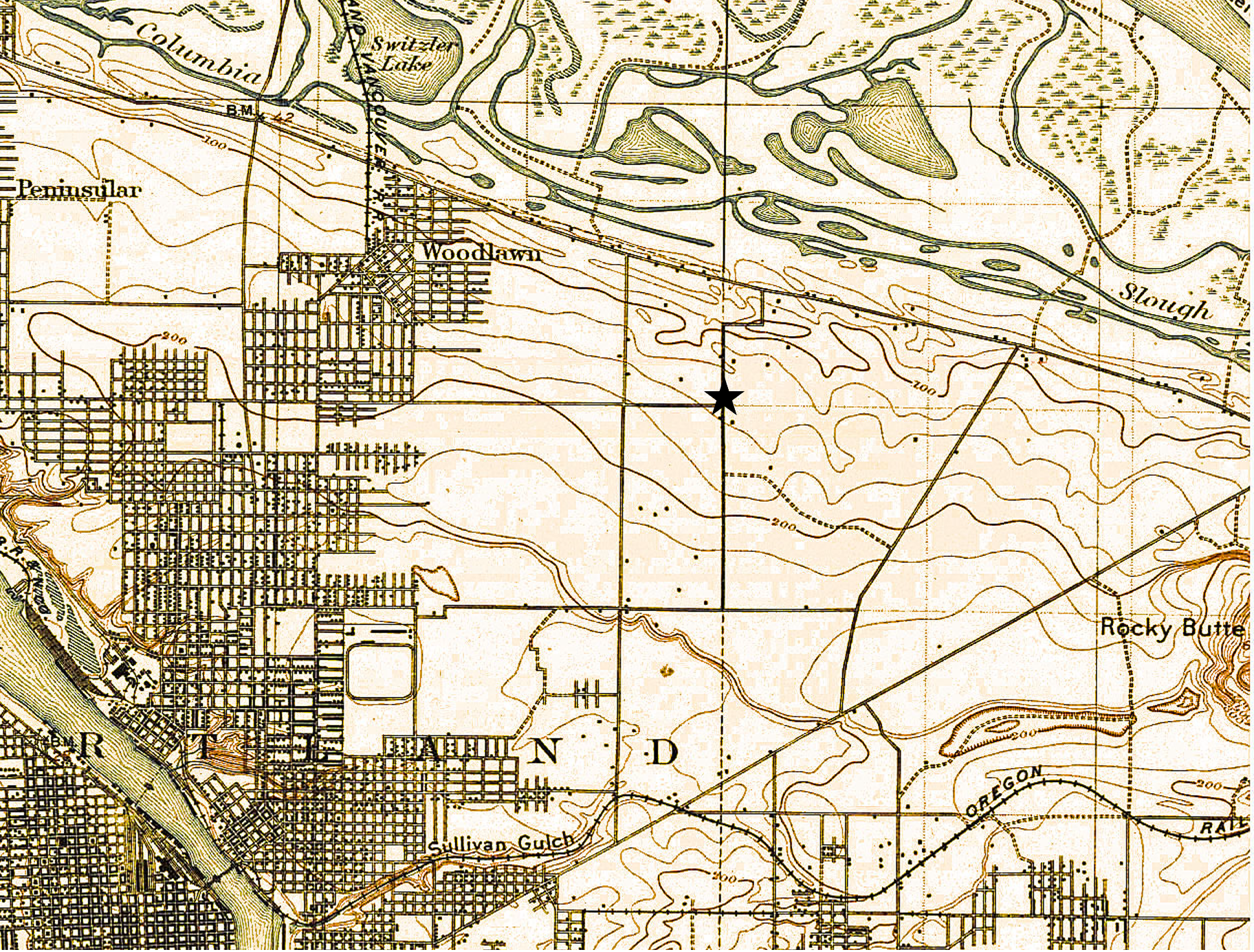
A patchwork of agriculture and development dotted the surrounding landscape with small farmsteads of orchards, berries and vegetables interspersed with homesites. Below is a detail from a USGS 1897 map of the area (star shows location of NE 42nd and Killingsworth). Notable here is that Killingsworth does not go farther east; development does not proceed much farther east than NE 7th; scattered farmsteads occupy the area of today’s neighborhoods; the Irvington race course at NE 7th and Fremont shows up in lower left.
Because of the area’s distance from the downtown core, its location beyond easy access to the streetcar system which promoted development, and its agricultural productivity, the crossroads remained largely rural until the opening of Portland Airbase in 1941, which was then a brand-new facility built on the reclaimed floodplain wetlands just south of the Columbia River.
Post-war boom ignites interest
The wartime expansion of manufacturing, residential growth and military operations drew new attention to the area, leading to transportation improvements and northern extension of NE 42nd Avenue with a viaduct over the Columbia River Highway, making it a major throughway from the eastside to the airbase. Residential and commercial development followed. Portland’s post-war housing boom in the 1950s led to further development, including more subdivisions, construction of a busy trailer park at the northeast corner of the intersection, and city acquisition of remaining nearby farm lands into what would become today’s Fernhill Park just to the northwest.
By the 1960s the area had been annexed into Portland proper. A commercial hub had developed at NE 42nd and Killingsworth including large and small grocery stores, service stations, bars, restaurants and light manufacturing. In the mid-1960s, the Portland School Board condemned a portion of the surrounding area to build John Adams High School, in direct opposition to residents’ wishes, razing homes and businesses. The school complex was later transitioned into Whitaker Middle School, and eventually torn down in 2006 due to changing student demographic needs and concerns about radon gas and the presence of unhealthy black mold found throughout the building.
It’s been a year since demolition of the old Spur Tavern and 42nd Avenue Tourist Cabins near the corner of NE 42nd and Holman. You might remember these buildings in their old age: bright green, broken down, painted over with graffiti, a little scary.
While researching them we met Mike Brink who spent some of his growing up years in one of the cabins, and also in his grandmother Ugar’s old farmhouse (now gone) a couple blocks away near the corner of NE 41st and Highland. Since that first conversation with Mike, we’ve been intrigued with his memory of walking through the open fields that are now built up neighborhoods west of Fernhill Park.
Whenever we’re over that way with the dog, we think of Mike’s open view across the fields toward Kennedy School; his every morning walk along the long block of Ainsworth to pick up the Alberta Streetcar at NE 30th and Ainsworth for the ride to St. Andrews school, at NE 9th and Alberta.
Recently, Mike sent along a few photos he came across taken out front at the tourist cabins. We thought AH readers might enjoy seeing them too, and a recent look at progress on what is now the construction site. So, have a look.
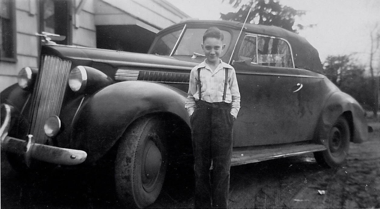
Here’s young Mike in about 1945 standing in front of his Uncle Joe’s pride and joy—a 1941 Packard convertible, parked in front of Cabin 6, behind the Spur Tavern.
Photo courtesy of Michael Brink
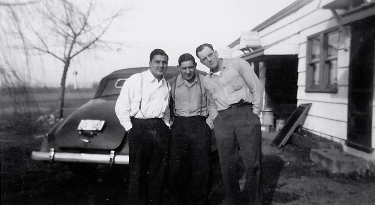
And here’s another: Mike’s dad, uncle and a pal in front of the tourist cabins, looking the other direction, open fields off to the north.
Photo courtesy of Michael Brink
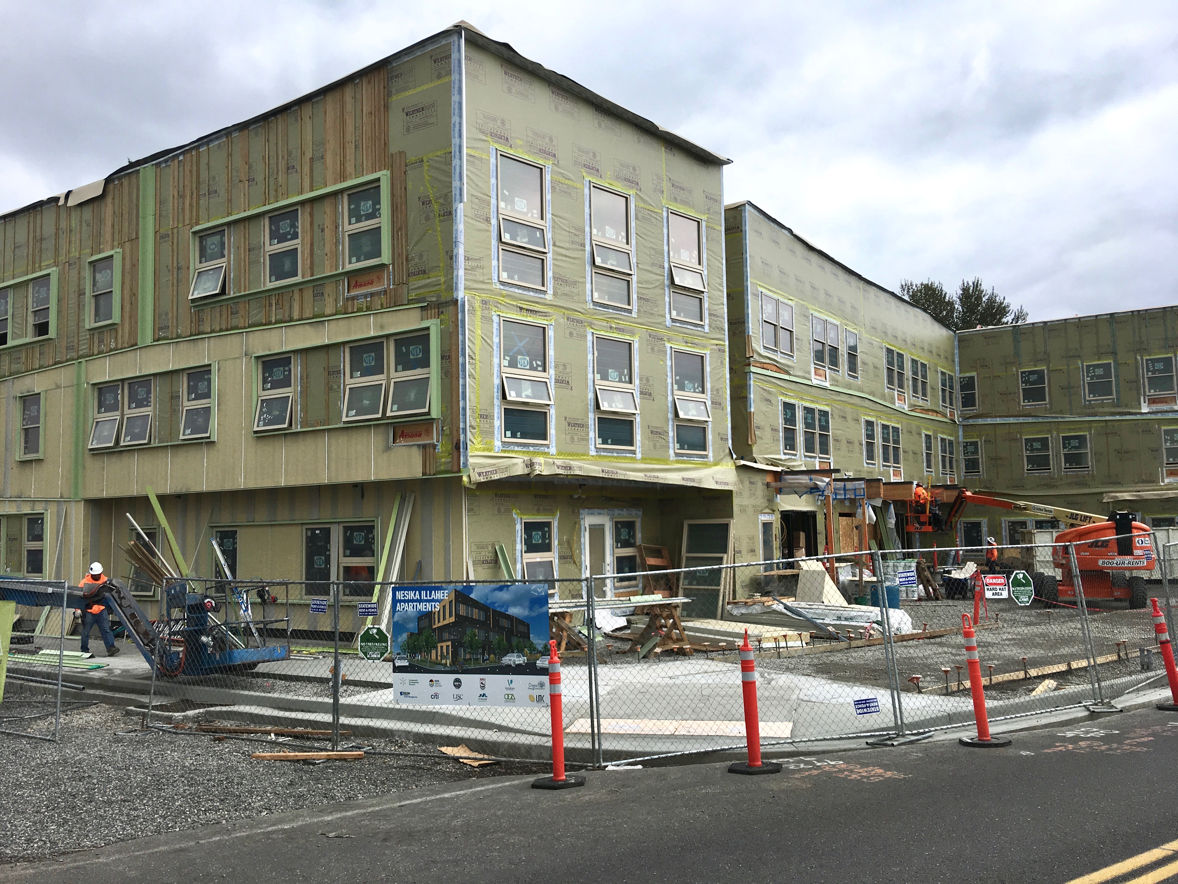
Here’s the update photo of what’s rising where the Spur and tourist cabins once stood, taken right about where Mike and his family posed for snapshots back in 1945.
Nesika Illahee Apartments, NE 42nd Avenue and Holman, October 2019
And here’s where it gets even more interesting, particularly when we consider layers of history. Long before the Spur, the tourist cabins and the farms on these gentle slopes, this part of the landscape was quite near the native village known as Neerchokioo, which existed along the south banks of the Columbia Slough.
The Nesika Illahee Apartments, under construction on this early village site, are a joint venture between the Native American Youth and Family Center and the Native American Rehabilitation Association, and will provide 59 units of affordable housing and culturally specific support for tribal members. Read more about this unique and fitting development.
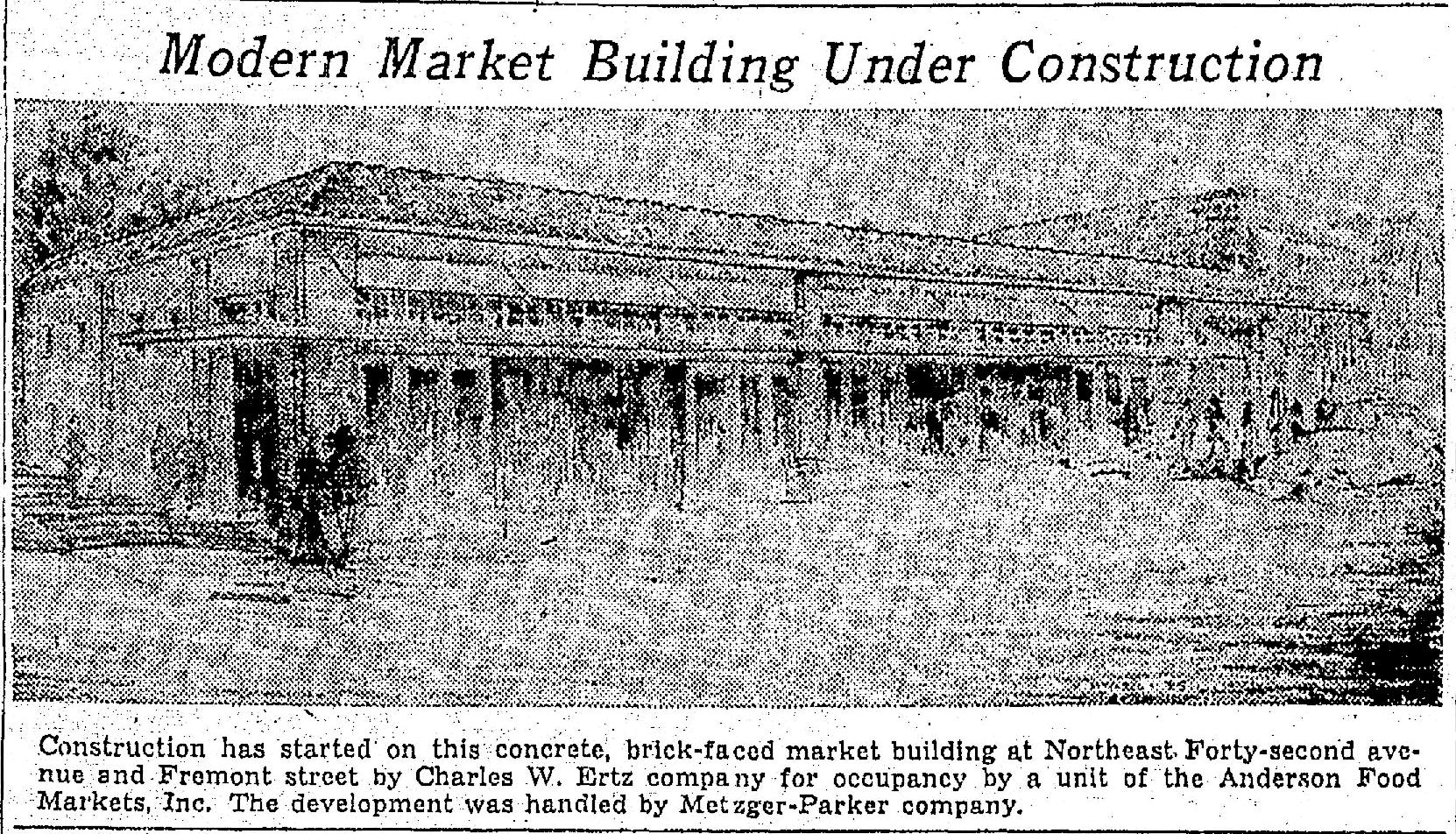
We’ve had the opportunity recently to research another prolific and talented architect from the early days of Northeast Portland. If you live in the neighborhood today, you probably know and have even been inside one of the buildings by architect Charles Walter Ertz: the Beaumont Market at NE 41st and Fremont. Take a look:
From The Oregonian, February 24, 1935
More on that Beaumont market corner in a moment…
Born in California in November 1887, Charles W. Ertz came to Portland as a teenager and acquired his architectural education mostly as an apprentice working for two of Portland’s leading architects, Joseph Jacobberger and Emil Schacht, both of whom designed homes in northeast Portland neighborhoods. Jacobberger designed the original Madeleine Parish school and church, and interestingly, years later, his son Francis designed the brick main sanctuary at Madeleine.
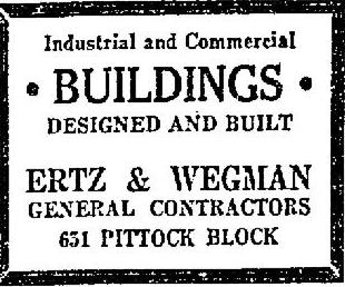
Ertz began his own practice with partner Lewis M. Dole in 1911 and later partnered with builder Edward C. Wegman as Ertz and Wegman for several years when the economy picked up following World War 1.
From The Oregonian, September 12, 1920
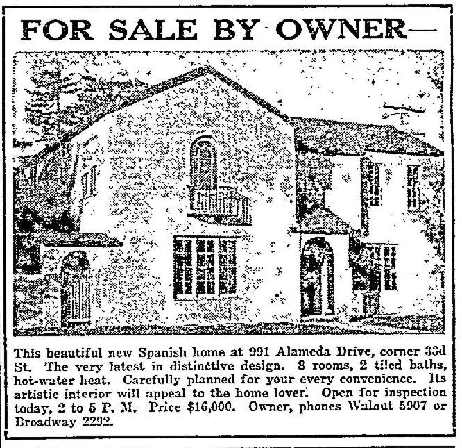
During the heyday of his Portland architectural practice, Ertz designed dozens of homes in Alameda and nearby neighborhoods, including several within a stone’s throw of each other near the Alameda Ridge: 3122 NE Alameda (built in 1918-1919); 3160 NE Bryce (built in 1919); 3027 NE Alameda (built in 1922); 3015 NE Alameda (built in 1922); 3260 NE Alameda (1924); and the Mediterranean-style house at 3297 NE Alameda (also built in 1922). Here’s an advertisement for that house, which is at the northwest corner of NE 33rd and Alameda:
From The Oregonian, November 26, 1922.
By the early 1920s, Ertz was back on his own until 1935 when he partnered with his employee Tom Burns to become Ertz, Burns and Company. He moved from Portland to Lake Oswego, where he designed and oversaw construction of several local landmarks there including the George Rogers Building at the corner of State Street and A Avenue (1925); the Jantzen House, on the island in Oswego Lake (1936); and his own beautiful Tudor revival home at 1650 North Shore Road (1928).
As his practice grew in the late 1920s and into the 1930s, Ertz kept Portland business ties but relocated to Beverly Hills in 1938 where he continued his practice until the 1970s. He died in Beverly Hills in 1979 at age 91.
Some of Ertz’s other memorable works include:
The A.B. Smith Automotive Building at 12th and Burnside that now houses Whole Foods;
The former clubhouse and restaurant at the Lloyd Golf Club, which was demolished last year (don’t get us started, it was a beautiful building);
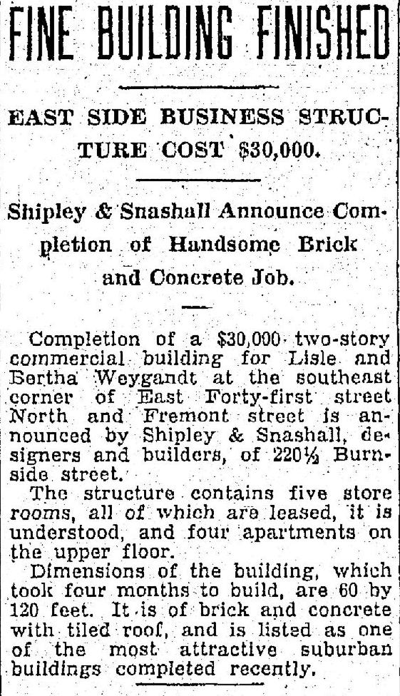
Back to the Beaumont corner of NE 42nd and Fremont: One of Ertz’s challenges with that 1935 project was to blend the design for his new market building into the existing context of the neighboring building. The multi-peaked tile-roofed commercial building just west of Beaumont Market was built in 1928. Most people visiting the corner today wouldn’t guess that they are actually two separate buildings, built seven years apart. That’s thanks to Charles W. Ertz who blended new with the old. Neither of those buildings were in place in the 1927 Beaumont photographs we’ve recently shared here.
An interesting note: that distinctive original building (the one that houses Gazelle and the other storefronts today) was designed and built by Shipley & Snashall, who built quite a few commercial corners on the eastside, including the building that today houses Peet’s Coffee at NE 15th and Broadway. Next time you pass by, have a look for the family resemblance.
We’ve been working on the history of Northeast Portland’s Fernhill Park this week, and it’s a fascinating tale of the city’s growth during the mid-20th Century, land use change, local politics and community engagement.
But we bumped into a story along the way that we have to share first because it’s going to be the next one that goes away and we have to appreciate it briefly while we can.
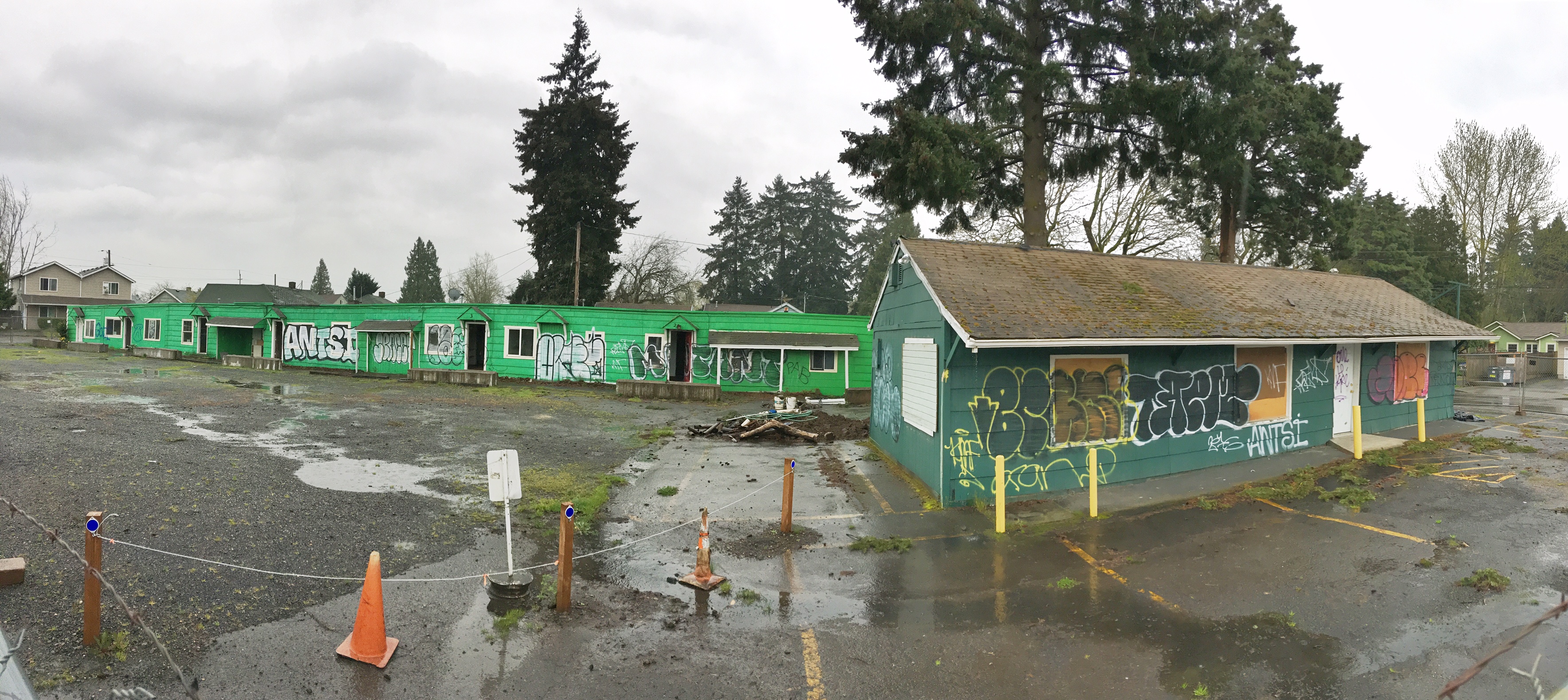
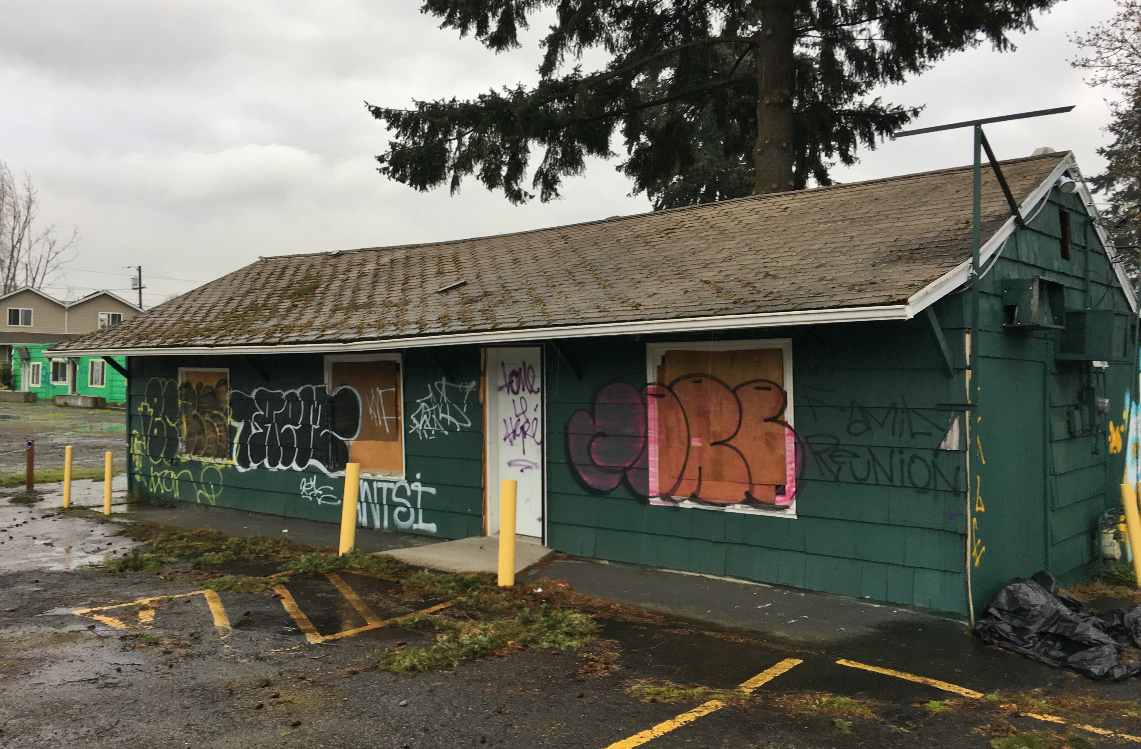
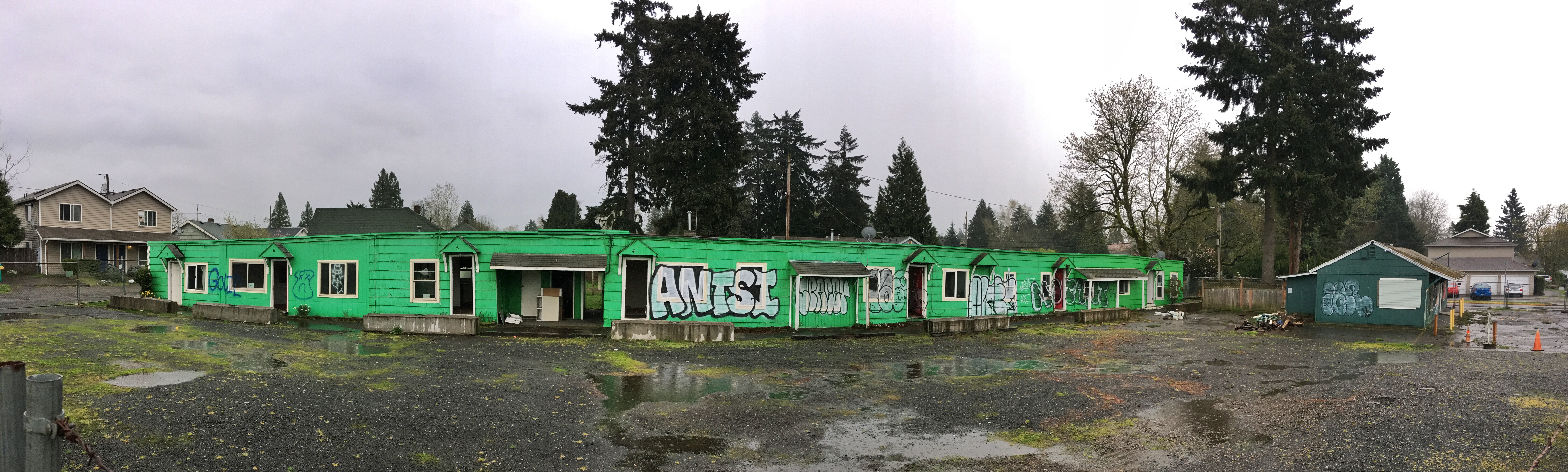
We’re talking about the old Spur Tavern and the garage-like apartments at the northeast corner of NE 42nd and Holman. Here they are:
NE 42nd and Holman, looking east, April 2017. In the mid-1940s, this was a community of returning WWII servicemen and their families, temporary workers and others passing through the Portland area.
The former Spur Tavern, built in 1942, 6300 NE 42nd Avenue.
These buildings have obviously known better days. Some might call them an eyesore, with broken and boarded up windows, tilting roofs and doorways and rotting siding, all spray painted with graffiti. A small ocean of cracked and buckling pavement and gravel surrounds it all, moss growing everywhere, branches down, junk piled. And for the moment it’s surrounded by barbed wire fence. When you see fence go up around buildings like this, you know things are about to happen.
In fact, this week the City of Portland issued a demolition permit, so if you want to go look, make it quick. We haven’t yet been able to connect with the owner, so we’re not sure what’s planned for the property. But we’re guessing most people are probably not going to miss these tired and dejected looking buildings.
But it wasn’t always this way.
Built in 1942, about the time NE 42nd Avenue was connected up to Columbia Boulevard and the new Portland airbase, the “Tourist Cabins” and Spur Tavern provided a sought-after home base for servicemen and their families on short assignment and others who needed temporary quarters for seasonal jobs or as a jumping off place into the next chapters of their lives.
When it was first built, from the front door of the Spur you could look out at agricultural fields in every direction. The Cully neighborhood to the south and east was already established and growing. Off to the west, across the open fields of what is today’s Fernhill Park and the eastern edge of the Concordia neighborhood, you could see the Kennedy School. To the north, more farm fields and dairies around the Columbia Slough and a beehive of activity at what was fast becoming the Portland Air Base and the new Portland airport.
The close-in fields and orchards were the livelihood of local families. One family of immigrants from Croatia lived in a 1917 farmhouse at the corner of today’s NE 41st and Highland Street (there was no Highland Street then). Home to the Anna and Josef Ugar family, this farm residence was completely surrounded by fields and orchards, with the nearest neighbor a quarter mile off to the west. You get the idea: this was the outskirts.
One young person who knew this place well and loved it for the adventure, family and community it provided, was Mike Brink, grandson of Anna and Josef Ugar. Mike split his growing up years between his grandparent’s farmhouse just to the west on the hill overlooking the fields, and the “cabin” at the far north end of the line of connected apartments.
Mike’s dad Bill was from Cascade Locks. In the 1930s, while helping build Bonneville Dam, Bill married Kay Ugar. After Mike was born, Bill shipped off to World War II, so young Mike and his Mom Kay headed home to the Ugar family farm in Northeast Portland. When his dad returned from the service, the young family stayed local, moving across NE 42nd Avenue to rent one of the tourist cabins.
Mike remembers:
“5 million men came home. Many to wives and families they hadn’t seen in years. There were no jobs. Insufficient housing. And many other societal problems. The cabins served a vital function for us. They were a virtual community. Everyone was in the same boat. Those of us who were there for a longer time formed close bonds. The Spur Tavern was a social hub. Some had difficulty finding work and spent too much time there. Others spent all their free time there. Weekends could get out of control at times.”
Mike recalls the modest means of many cabin residents, and how from time to time when rent was hard to come by, the landlord Al Druery, who also ran the Spur Tavern, would cover a family who needed help with groceries until payday.
“He [Al] also collected the rent for the cabins. He lived in the end cabin—#1 – right behind the tavern. I remember him as a harried looking man who looked like he drank too much himself but I don’t remember anyone ever having a real problem with him. I remember if we were low on milk or coffee or bread or some other staple my mom would send me over to the Spur and they would give me what ever we needed and put it on our bill. And all of us worked together to convert the garages to additional living space and finish the interior. Then there would be a big party. There was a rotating weekly pinochle game. It couldn’t have been too bad.”
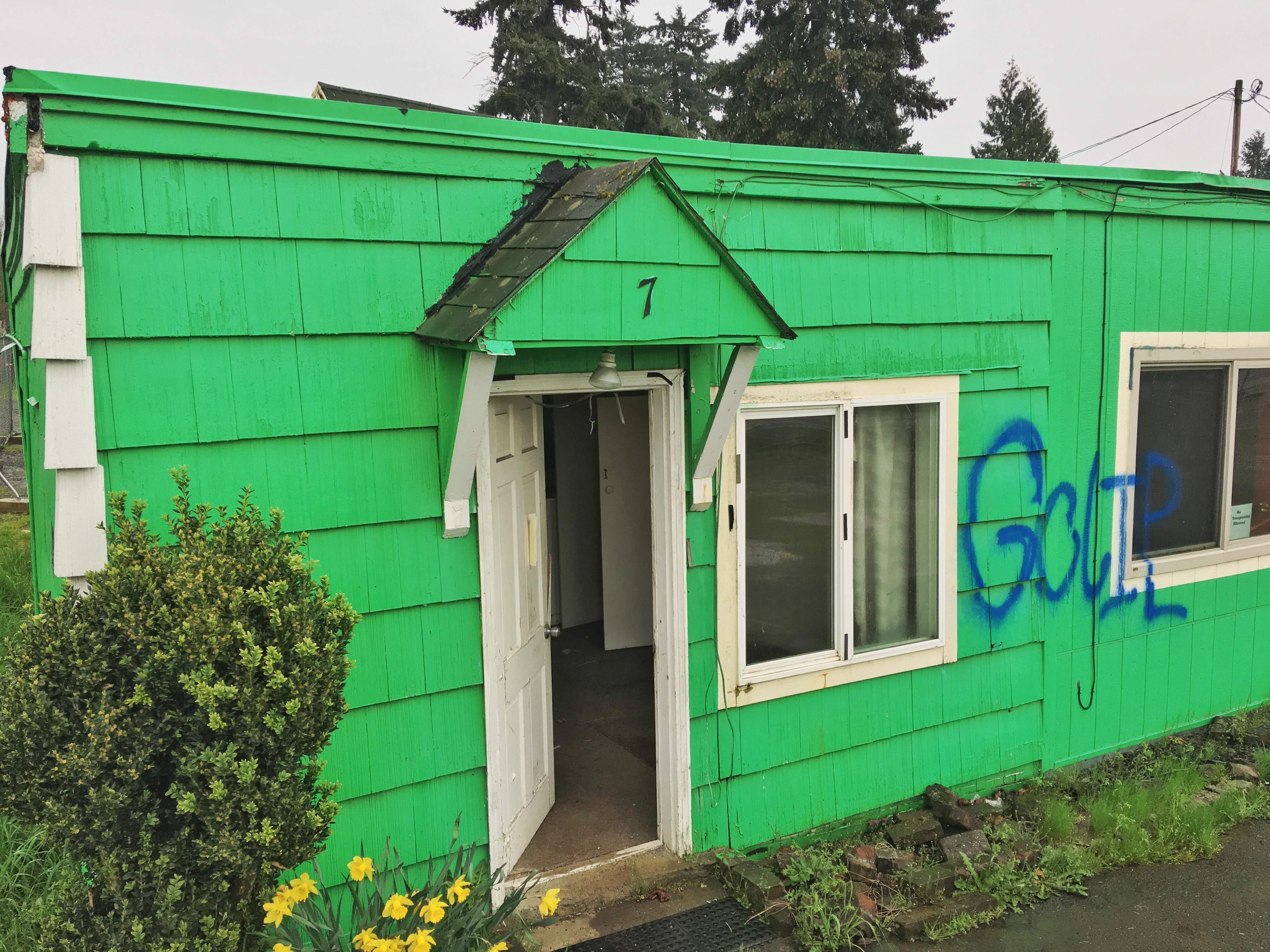
Mike recalls how the long line of cabins used to include garages, but residents gradually converted them to living space, which was a premium as families grew. Here’s a current photo, and memories from Mike that help evoke that life and times:
Cabin # 7, 6300 NE 42nd Avenue, April 2017. Note the daffodils by the front door, a remnant of more optimistic times.
“We had a ‘hide-a-bed’ couch in the little room you can see through the partially open door. My folks made that up each night and slept on it. I slept in the area to the left of the door on an old wooden and canvas fold up army cot that we made up each night. There was a small table and three chairs behind the couch and a little kitchenette along the back wall. In the northeast corner was a really small ‘bathroom’ with a shower. It was so small my grandfather commented when he came to visit for the first time, ‘That bathroom is so small you have to decide what you are going to do before you go in.’”
“The area to the right of the front window was the garage for the unit next door. There is a wall there now because after a year or so, when that unit became vacant, my father persuaded the landlord to let him enclose that area and finish the inside. We moved into that unit and the finished garage became my parents bedroom. I then got the hide-a-bed in the ‘living room’ of that unit. It also had a real bathroom and a bigger kitchen. We lived there until 1949-one social strata above the Joads!”
The Spur Tavern was the proverbial watering hole where residents of the cabins, servicemen and people passing through stopped in for a beer and a snack. Mike remembers:
“The Spur was a busy place. It was a ‘beer joint’ in the truest sense of the word. A long bar with round swivel seats running south to north with the bartender behind the bar facing west. Pickled eggs in jars on the bar along with ‘punchboards.’ Two pin ball machines and a juke box in the north end. And cigarette smoke so thick I’d have to squint to see my dad when I went to get him. There were a few plywood booths along the west wall and in the south end. There were rest rooms in the southeast corner with a door going out back to the east. They had sandwiches and pickles but I don’t remember any chips. They made coffee but only in the morning and at night. I remember for a while they had ice cream and made milk shakes. But, no one went there for the food. During the period right after WWII jobs were scarce and the Spur was busy pretty much all day. Most of the patrons then, and I remember they all were men, were mostly guys just ‘hangin’ out’. Sippin’ a beer or two, or three. There was rarely any trouble. Evenings were about the same. A little bigger crowd 15-20 maybe, a little noisier but rarely rowdy. On the weekends, though, it could be busy and noisy and go on late—loud music, loud voices, cigarette smoke and honky tonk women. There were some loud arguments and some fights but I never knew of anything to get really out of control. I think the real problems came much later when the the drug culture took over the cabins and the Spur. I think it had a pretty well known reputation as a crack house.”
Newsprint and photos are always helpful to record the facts, but personal memories like these are what keeps places known and alive, so even after the Spur and tourist cabins have been demolished and hauled off, many indelible memories for Mike Brink will linger on, including this last one related to the end of World War II:
I still remember V-J Day. I was playing catch with my friend Bobby Collins in front of the cabins and traffic on 42nd Street got very heavy with many cars going very fast in both directions, the drivers honking their horns and people hanging out the windows and yelling. I’m sure you know 42nd was the main axis route to the air base. It scared the hell out of me. I ran in the house (cabin) and my mother had the radio on and told me the news.
Thanks for the memories, Mike. We’ll hold onto these so the future can remember the past.


