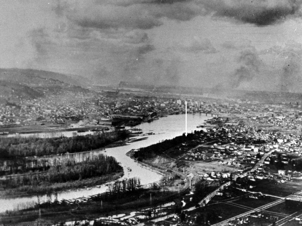
Looking north through southeast Portland and along the shoulder of Ross Island, about 1925. The arrow shows the approximate location of a house somewhere in the mist we wanted to know more about. Image courtesy Portland City Archives, A2011-006.
Sleuthing old photos to determine location, context and insights is a favorite thing to do; the Photo Detective category here on the blog is testament.
But sometimes, the biggest mystery is just finding the old photo.
Such was the case recently when a reader wrote seeking an assist in locating a photograph of a house fixed in childhood memory from the 1950s: his grandparents’ home on the bluff above Ross Island, torn down more than 50 years ago to make room for McLoughlin Boulevard. No known photos of the house had survived.
But in his memory, a version of the house was still there. Burnished over the years and important because it was a house that contained the full arc of life for people he cared about who were also gone. Maybe by having a photo of the house, he could call them to mind, and consider his own experience there as a small person.
When researching houses for clients, we’re always looking for old photos, but there is no single source or easy way to do this. In Portland, it’s worth following your address back through old copies of The Oregonian and the Oregon Journal to see if there is a photo from an advertisement or some random mention over the years. You’d be surprised, it does happen.
Another potential source is Portland City Archives, which has a deep collection of public works, traffic study, zoning study and “stub toe” photos that might include an incidental catch of a place or building of interest somewhere in the background. You can use the search tool called efiles to search by intersection or street.
The stub toe photos are an interesting subset, documenting sidewalk tripping hazards for liability reasons and occasionally catching a house of interest in the background.
The Oregon Historical Society Library has collections of neighborhood photos that are always worth looking through: you might find something you didn’t even know you were looking for.
There are aerial photos too, some of which are available through City Archives, and others through the University of Oregon Library’s Aerial Photography Collection. Dating back to 1925, these images are mostly low resolution and grainy, but good enough to help address larger-scale mysteries. Examining the same place from the air every 5-10 years back to 1925 is fascinating and always humbling to see all we’ve missed and don’t know about a place.
An advanced aerial photo function within the indispensable research tool Portland Maps allows a year-by-year look back to 2006 and then in some cases back to 1948. And of course there is Google Streetview.
But the best sources with the best pictures are always private collections, as in family photo albums and attic shoe boxes of photos, which are also the most challenging and rewarding to find. But that’s another blog post.
Long before construction of McLoughlin Boulevard, the remembered house on the bluff had a Grand Avenue address, and stood on the east side of the street at the corner of Haig. Back in 1912, Grand Avenue was never intended to be a major thoroughfare connecting downtown and the central eastside with outer southeast Portland. Think: quiet, meandering neighborhood street.
Early on in the search, we used aerial photos and Sanborn maps to understand how Grand Avenue has changed. It once followed a slow, looping route along the high bluff to take in the views of the Willamette River to the west, calling to mind the way in which SE Sellwood Boulevard edges high above Oaks Bottom today. In the river just downslope from the house was the north end of Ross Island, with views straight at Bundy’s Baths and Windemuth.
It wasn’t until the late 1930s and early 1940s that Grand Avenue was widened and McLoughlin Boulevard first opened. Given growth in all parts of southeast Portland and northern Clackamas County—and the rise of the automobile in everyday life—traffic volumes began to increase and congestion followed. The Oregon Highway Commission was under pressure to “fix” the problem. By the mid 1960s, traffic engineers with the State Highway Division knew that widening of McLoughlin to six lanes—which had become Pacific Highway East, Route 99E—would be necessary, dooming the former neighborhood street.
By then, the remembered family in the remembered house were gone and the sense of that former neighborhood as a quiet place to look out over the river below was quickly slipping from living memory.
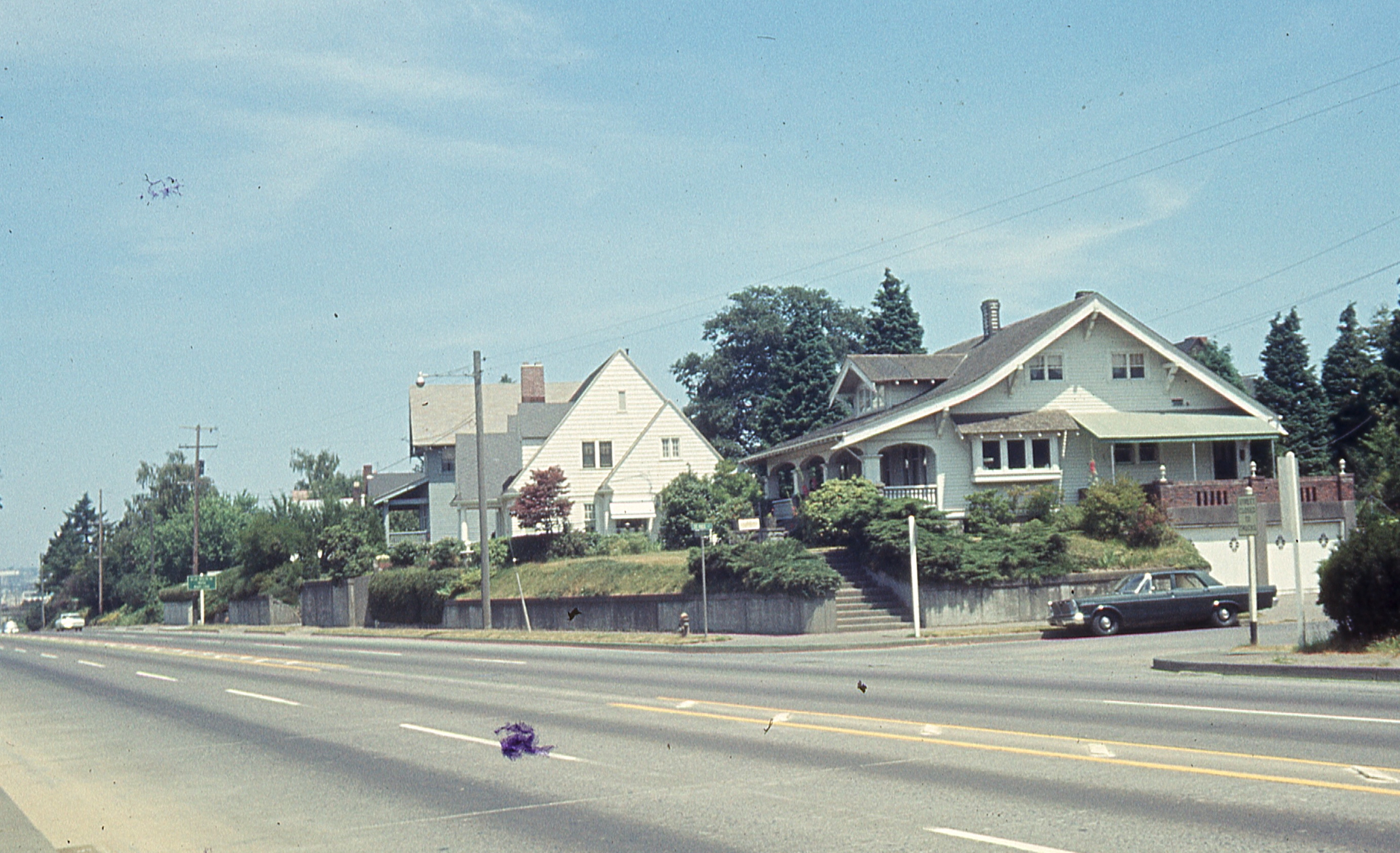
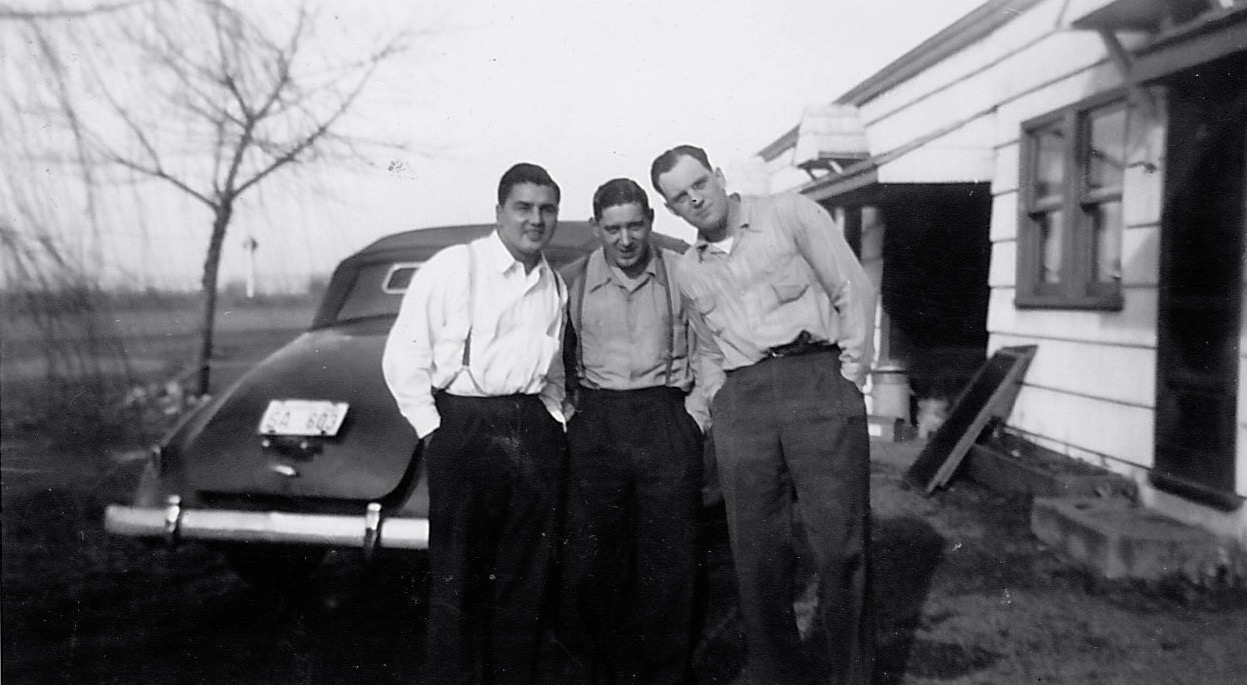
That’s when the studies began: land use studies, traffic flow studies, engineering studies. Surveyors out on the ground taking measurements, and–fortunately for us–taking pictures. And that’s where we were able to pull this house back to life from one sunny Wednesday afternoon in June 1965, through the lens of a traffic engineer. That’s it there on the right, the Craftsman bungalow, dormer facing west. Click in for a closer look.
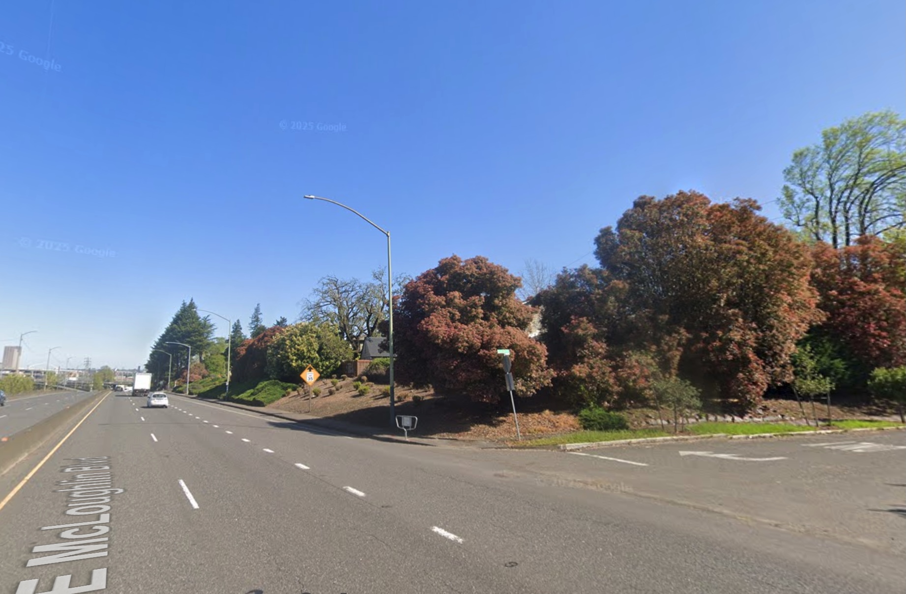
The former 670 Grand Avenue, a story-and-a-half bungalow built in the spring and summer of 1912 by Benjamin F. Doty, a well-known Portland homebuilding contractor and as it turned out father of the young newlywed who lived in this house for most of the rest of her life. This house and nine other adjacent homes from the old neighborhood were torn down in 1970 to make way for another lane of traffic on McLoughlin Boulevard. Below: the same view today (thanks to Google Streetview).
How does the photo compare with the memory? Maybe an unfair question since how does memory ever compare with anything, but we wanted to know. Certain things were familiar.
But just having the photo created a perch from which other memories and imaginings and questions could now rise. And for an old house researcher like us, it felt like finding the precious needle in the overwhelming haystack.
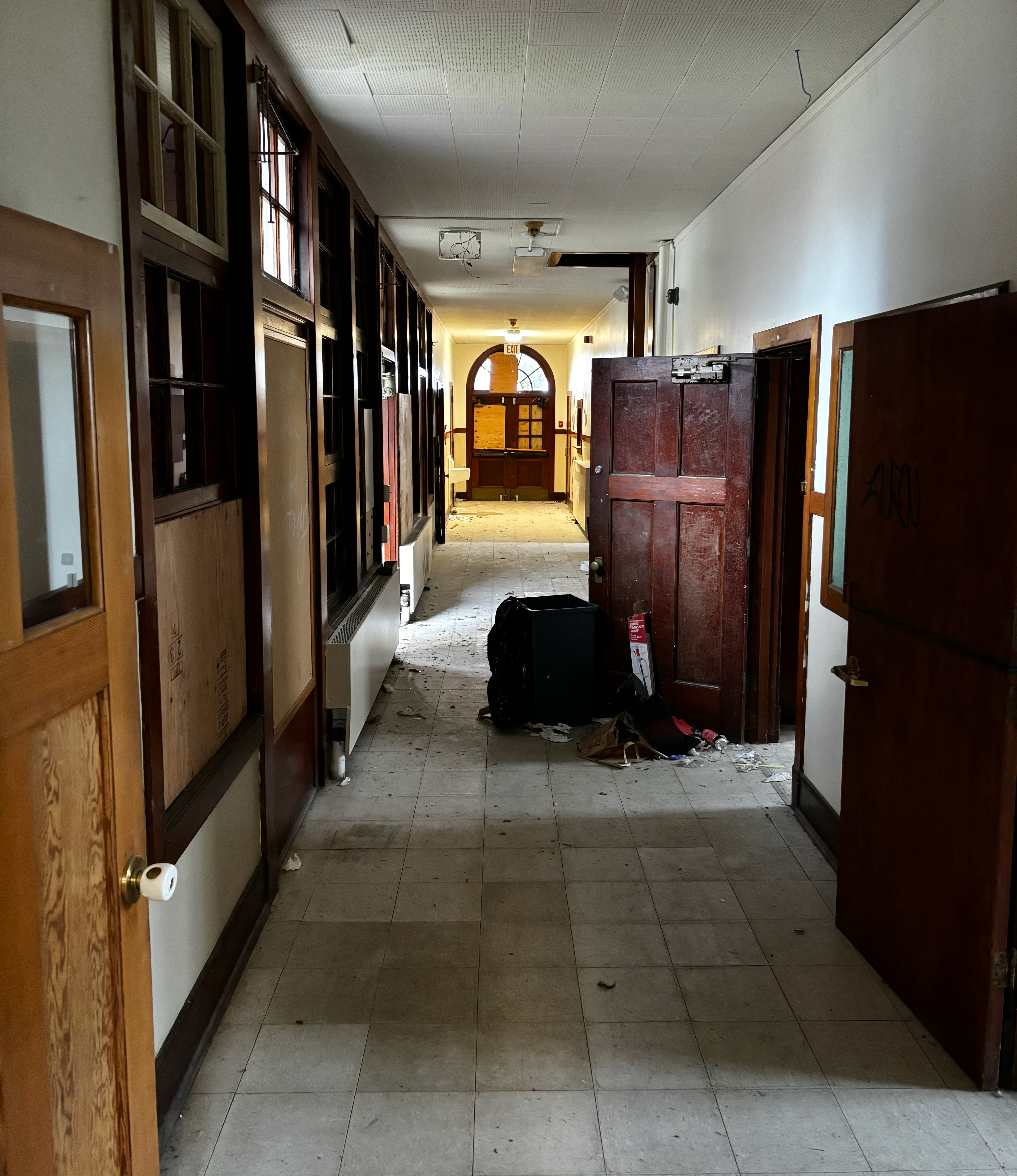
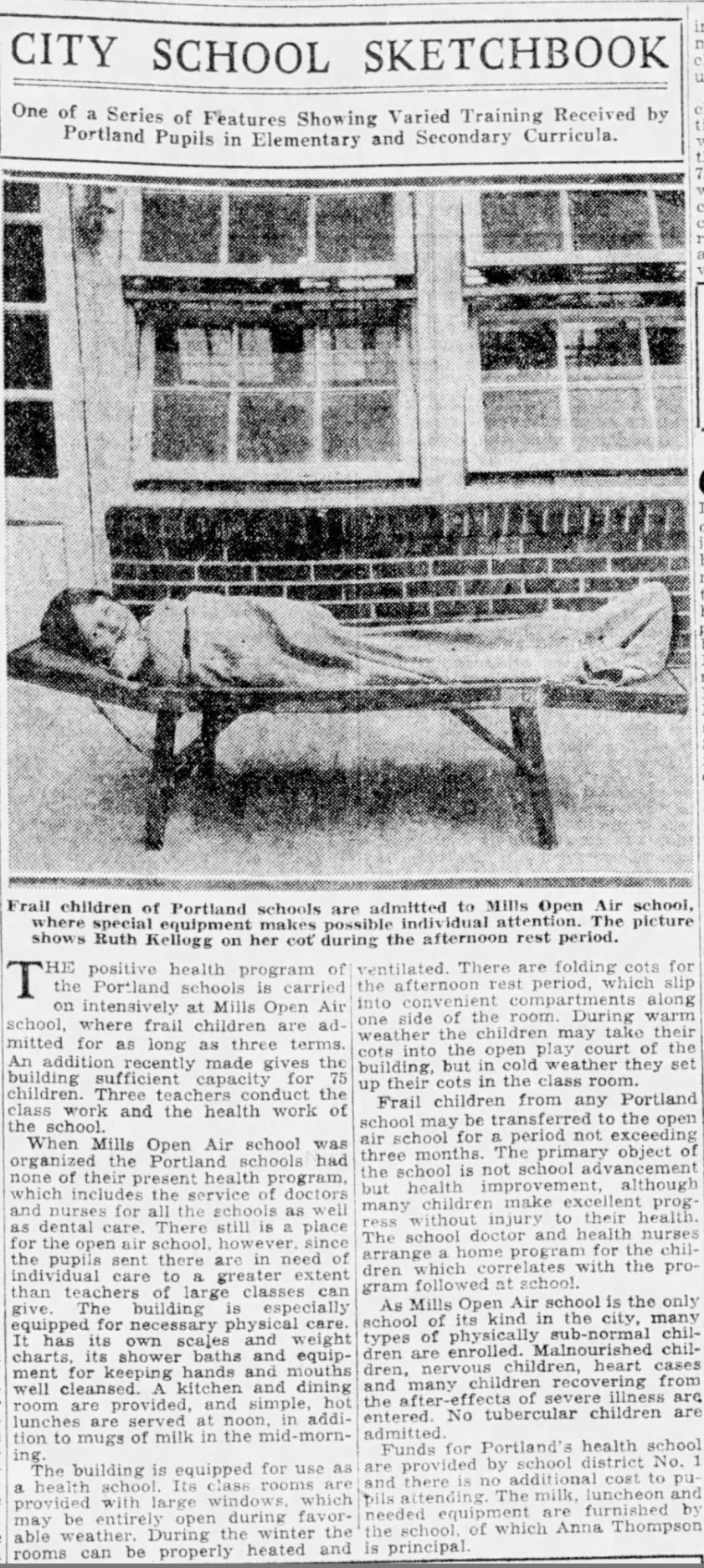
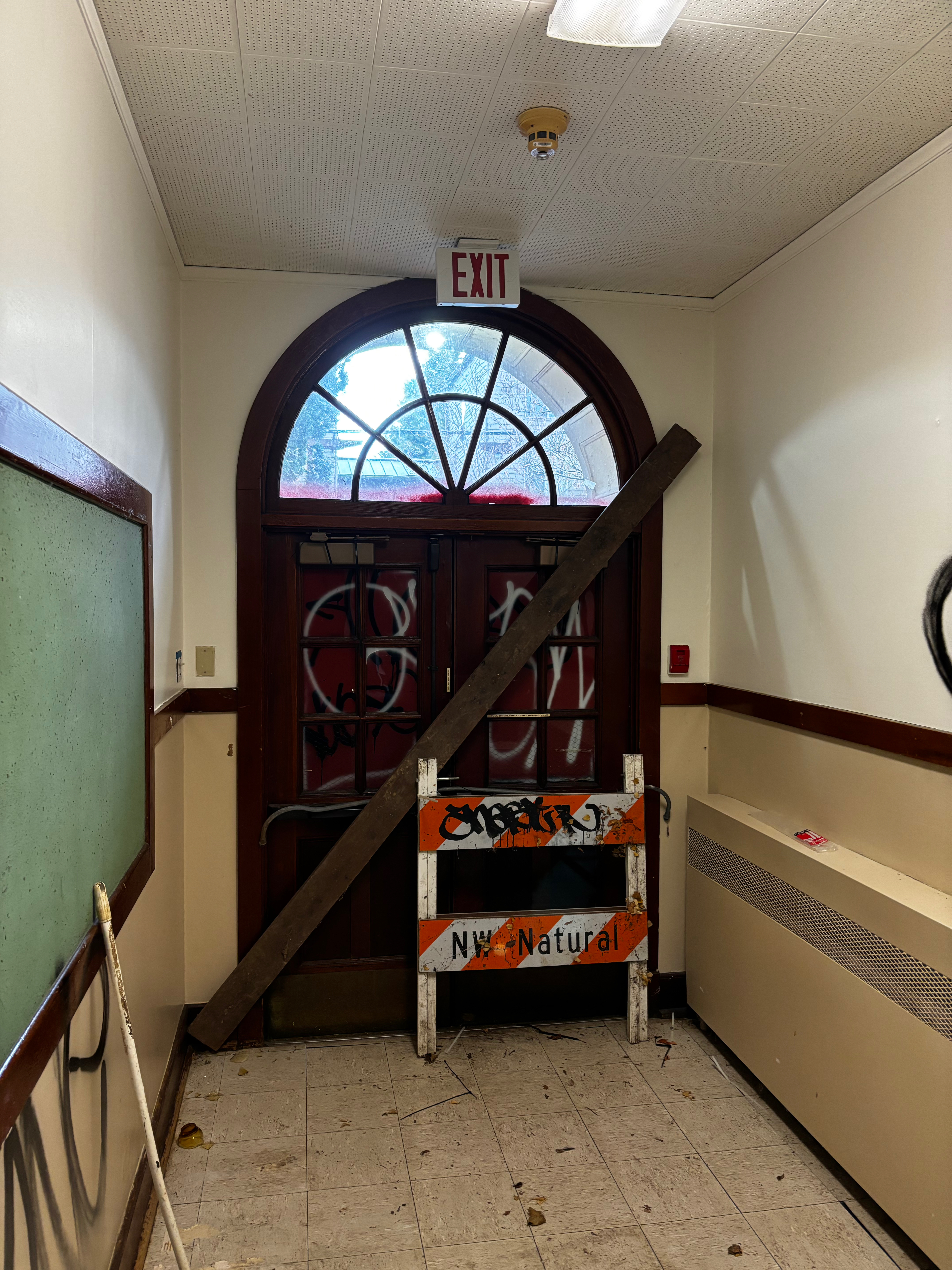
Last weekend marked the final public tour of the A.L. Mills Open Air School at the southwest corner of SE 60th and Stark in the Mt. Tabor neighborhood.
The empty long hallway at Open Air School, December 2024. The building has been empty since 2019.
The former school building, built in 1918-1919, will soon be deconstructed by the Portland Housing Bureau (PHB) to make way for an affordable housing development. For the last six weeks, we’ve been working with the Bureau and the Mt. Tabor Neighborhood Association to share stories of the building with neighbors and anyone interested in having a last look.
Some came because they’ve watched the old school’s recent decline, seen the graffiti and cyclone fence sprout and wondered what was inside. Others came because they’ve had connections to one of the four chapters of its earlier life. Everyone wanted to know what would come next.
A.L. Mills Open Air School first of its kind
When it opened in 1919, the Abbott L. Mills Open Air School put Portland on the map nationally and internationally as the nation’s first entirely purpose-built open-air school, meaning that students and teachers spent their entire school day surrounded by fresh air. A handful of other communities across the country had experimented with a classroom here or there in an existing school. In Portland, the original Irvington School featured one open air classroom where the windows were open all day, all school year.
But with financial help and encouragement from the Oregon Tuberculosis Association, Portland Public Schools was able to build an entire school dedicated to helping “low vitality children” improve their health and therefore their resiliency to tuberculosis, which was a serious health threat of that era killing hundreds of thousands of people of all ages in the U.S. during the 1920s.
From the Oregon Journal, November 30, 1919
The Oregon Tuberculosis Association was led by Abbot L. Mills, former Oregon Speaker of the House, philanthropist, president of the First National Bank of Portland, and chief organizer of the Portland Open Air Sanatorium for Consumptives. Mills, who earlier served as vice president of the 1905 Lewis and Clark Exposition, was a tireless public health advocate around tuberculosis, and the chief push on funding for the school, so it’s entirely appropriate the building bears his name.
The open-air movement was an international public health philosophy based on the notion that being exposed to fresh, circulating air kept children, and people of all ages, healthier.
60th and Stark: Epicenter of Mt. Tabor community and Portland’s health spas
That’s why school and health officials selected the western slopes of Mt. Tabor, then a rural and bucolic elevated place distant from the churn of downtown Portland (Mt. Tabor was annexed into Portland in 1905). In 1902, the Portland Sanitarium opened just a block away at 60th and Belmont (site of the former Adventist Hospital). Another private sanitarium operated at 60th and Yamhill.
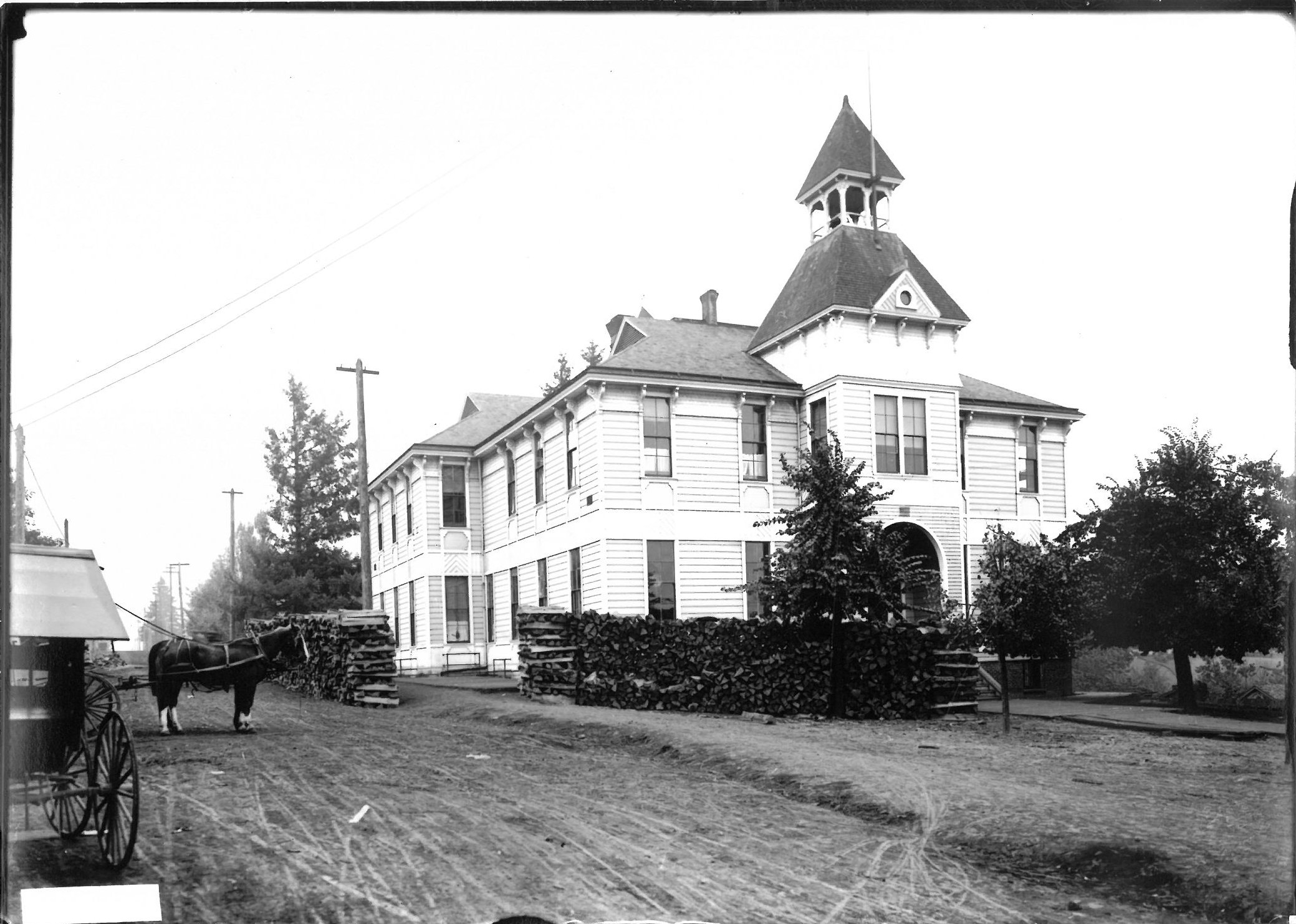
60th and Stark was also the crossroads and heart of the Mt. Tabor community. From 1880 until 1911 a former school operated on the site. Before that, a frontier school operated out of a log building in the same place.
Looking south on 60th at the corner with Stark (then known as Baseline Road), about 1907, four years before this school burned, clearing the site that has hosted the Open Air School since 1918. Drying cordwood is stacked for the furnace in the old school. Courtesy of the Oregon Historical Society, image Org-Lot-982, Box 8 Folder 6.
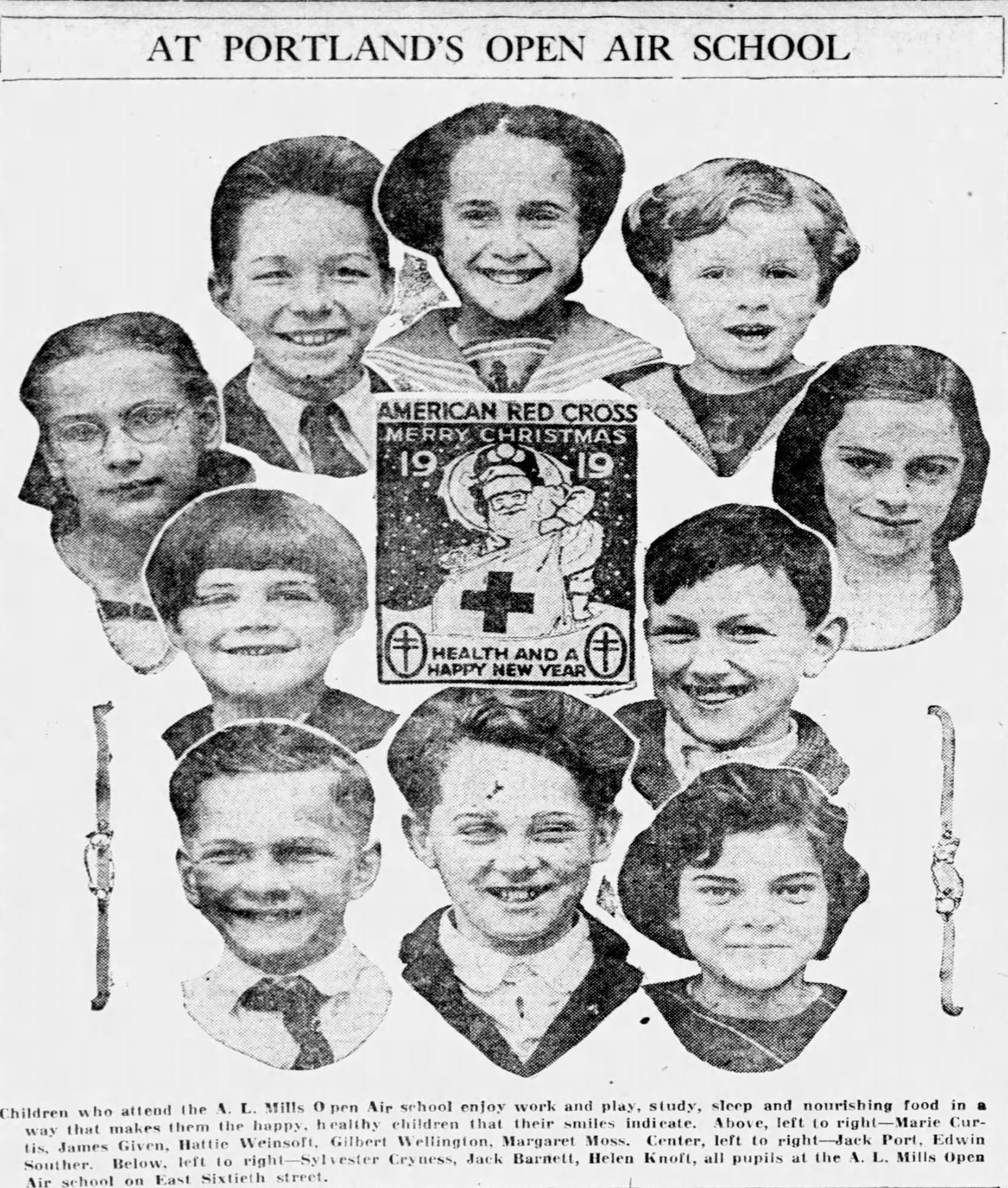
The two-room A.L. Mills Open Air School opened on January 27, 1919 with its full capacity of 50 students ages 5-15, two teachers and care team.
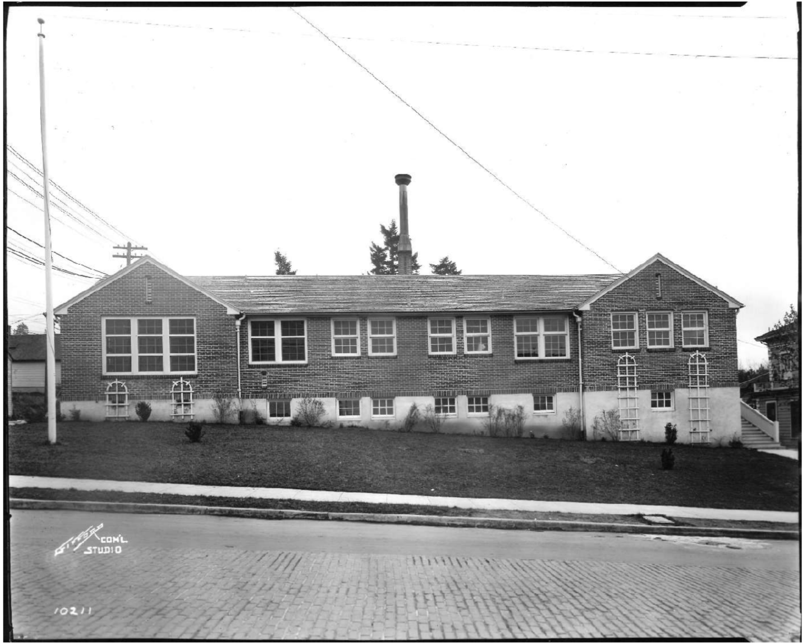
The Stark Street side of Open Air. Photograph Courtesy of the Oregon Historical Society, from the Ben Gifford Collection Box 8, Folder 5.Gifford photographed the school not long after its opening on January 27, 1919.
Miss Anna Thompson was principal of “Open Air,” its often-used nickname, and she never missed an opportunity to let everyone know her students were not tuberculous: they were children with health infirmities that made them vulnerable to TB.
Here’s an essay by Principal Thompson that appeared in The Oregonian on May 14, 1925:
“Because of the ardent interest and material support given by the Oregon Tuberculosis Association in the early history of the school, many people believe ‘Open Air’ to be a school for tuberculous children. This is a very grave mistake. Children who are tuberculous or infections from any cause whatsoever are not admitted. I want this fact impressed on parents and others. We are trying to prevent these children from growing into defective conditions–the purpose is preventative not remedial.“
Got that? Not a place for sick children: Miss Thompson and her colleagues were trying to keep them from getting sick.
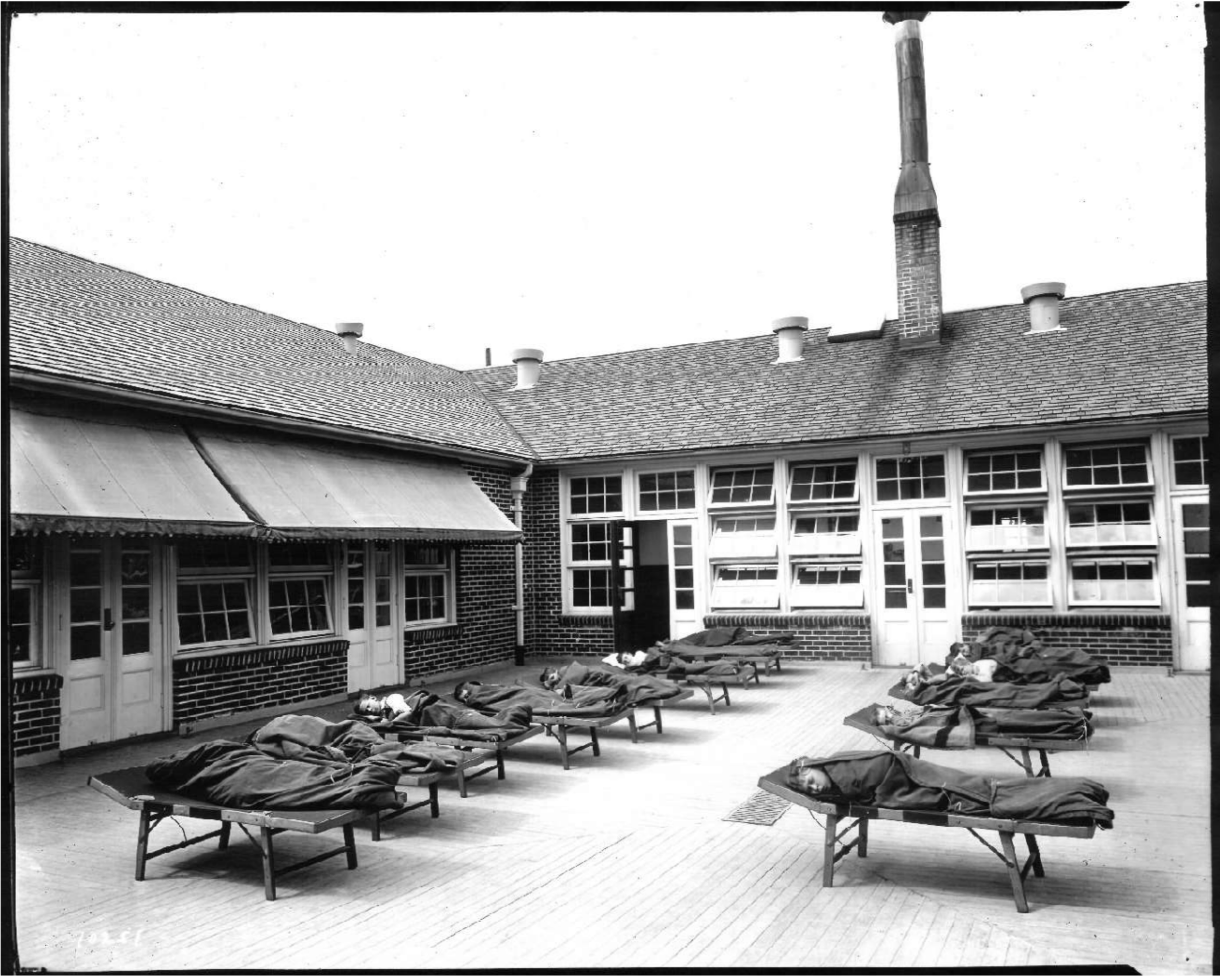
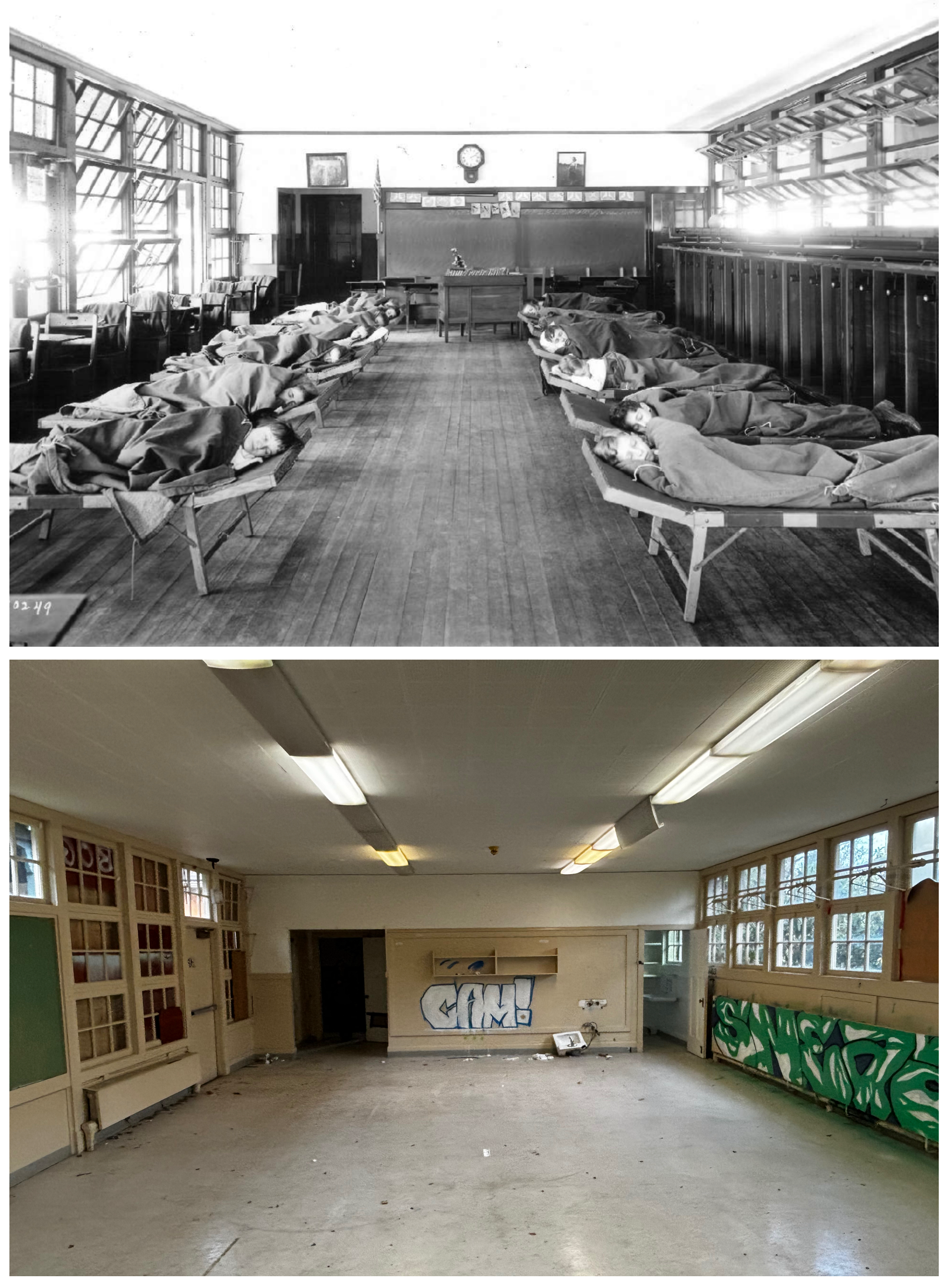
Afternoon nap time at Open Air. Photograph Courtesy of the Oregon Historical Society, from the Ben Gifford Collection Box 8, Folder 5.
Staff at Open Air included Principal Thompson, who also taught in one of the two rooms; a physician who was on site every Wednesday to examine each child; a full-time nurse; a matron who helped with showers, hygiene and meals; and a second teacher. The nurse visited each student’s home multiple times to make a plan with parents about how to work together and to keep tabs on progress.
There were places for 50 students, drawn from all walks of life across the city. Their families applied and the children had to be examined by the doctor and nurse to be admitted, and to stay enrolled. Students could stay up to three terms to rebuild their weight and improve their health before going back to their neighborhood schools, so the composition of the student body shifted each term.
From The Oregonian, February 10, 1931.
In the 1920 school year, 77 total students were in attendance, which means 27 of them were “restored to health” and transferred back to their neighborhood schools, allowing other children to be admitted. The Oregonian in 1920 reported that at one point 15 of the 50 children were “only children,” who theoretically had the undivided attention of their parents–no siblings–a point that Principal Thompson liked to make, perhaps to bolster the fact that unhealthiness was not necessarily related to a lack of resources or attention.
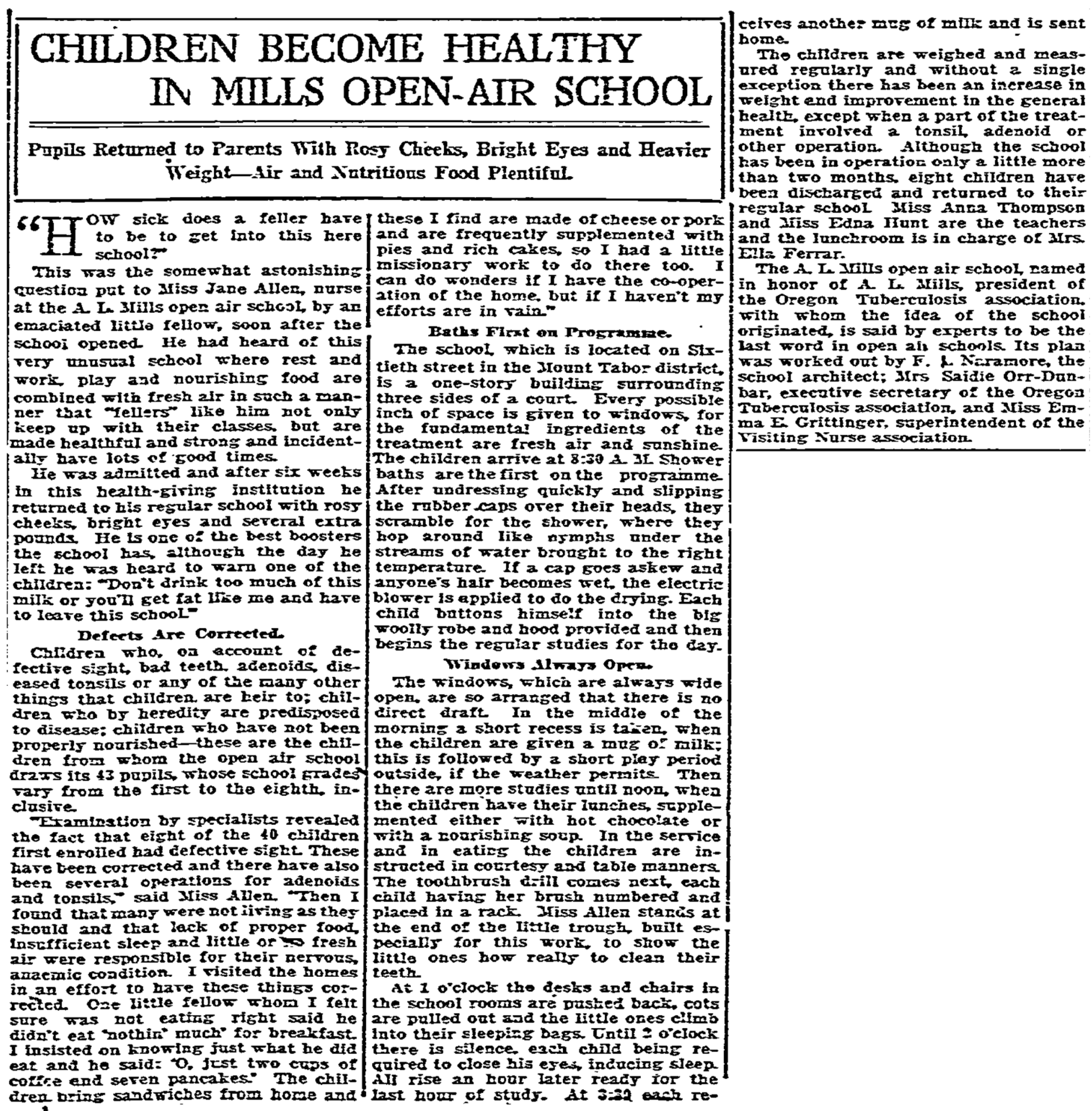
A great description of a day in the life of Open Air ran in The Oregonian on December 10, 1922:
“Shower baths are the first order of the day at 8:00 and during this period once a week the pupils are weighed and inspected for symptoms of physical defects. After baths the pupils put on their sitting robes of heavy blanket material and enter the open window classrooms where they attend their studies until 10:25 at which time half a pint of milk is served in the lunch room to each pupil. This is followed by a period of supervised recreation. When the weather permits games are played on the court or lawn.
“The entire noon hour is given up in preparation for lunch, eating lunch, and preparation for rest. Getting ready for lunch requires washing face and hands, cleaning fingernails, combing hair.
“A copy of the menu of hot dishes for the following week’s lunches is sent home each Friday, so that the mothers will know how to supplement them with the right kind of sandwiches and other foods. For the past week, the menu has been: Monday, hot milk toast; Tuesday, apple tapioca; Wednesday, lamb stew with vegetables; Thursday, hot cocoa; Friday, hot rice”
“After the midday meal, the teeth are brushed and pupils returned to classroom where preparation for rest is made. Cots are spread with warm blankets and after a few vigorous breathing exercises, the rest period begins. At 2:00, the children rise from the cots, faces are washed and hair is combed and studies are resumed until 3:25 when milk is again served and the pupils are dismissed.“
From The Oregonian, December 10, 1922
In cold weather, the children wore heavy robes (pictured above) which were called “Eskimaux suits,” described like this in that same story:
“The brownie coveralls with hood provided by the school to be worn on chilly days are like a fraternity emblem among the pupils and are decidedly popular as their insignia of privileged rank. Sleeping robes are also provided, made of canvas lined with gray woolen blankets that launder well.“
An observation of impact and results were noted in this story from The Oregonian on April 20, 1919, just a few months after the school opened:
From The Oregonian, April 20, 1919
Repurposed to meet current needs
By the late 1940s, the baby boom of Portland’s school-age children brought neighborhood schools to full capacity. With tuberculosis receding as a health threat and the need to make more space, the school board chose to close Open Air, sending students back to their neighborhood schools, and reconfiguring the building as Mt. Tabor Annex, the venue for all kindergarten and first-grade children from Mt. Tabor. A third classroom was built and the converted annex operated as a regular school until 1973.
When the population of school-age children receded, the building was surplussed, ending up in the portfolio of Portland Parks and Recreation, where it was once again repurposed, operating from 1974-1990 as the Mt. Tabor Community Arts Program and Community Theater Workshop.
Budget cuts in the 1990s ended the community arts and theater programs and the building was fallow for several years and on track to be sold to a private school operator, which ended up not happening. In 1994, Parks and Recreation leased the building to the YMCA, which operated it as a daycare for 25 years, until 2019. Operating costs and deferred maintenance ended that chapter just as the pandemic descended, and the old school was once again surplussed, eventually acquired by the Portland Housing Bureau. It’s been vacant since as the Housing Bureau has considered its options.
What’s Next
On each of the recent tours, PHB Capital Projects Manager Kate Piper explained to neighbors that the bureau will soon be deconstructing the old school and salvaging as much of the building material as possible. Redevelopment plans are not yet clear on what happens after that, or when, but removing the existing building from the site is a high priority to manage liability and to set the stage for future development.
This fall’s public tours of the building have helped resurrect and appreciate the stories of Open Air’s past. This time traveler will be going away, but the site has always been a place of change and evolution, meeting the community’s most pressing needs.
No one on the tours questioned the importance of housing, though most couldn’t help but be moved by the stories that have played out there: of Principal Anna Thompson and her team, the children—each on their own pathway to vitality—and the will of a community investing hope and energy in its most vulnerable.
With thanks to colleagues Paul Leistner, President of the Mt. Tabor Neighborhood Association; Kristen Minor, Architectural Historian who completed a detailed survey of the property; and Kate Piper at PHB for recognizing the importance of sharing the Open Air story and connecting with the neighborhood.
This month we’ve been working with the Portland Housing Bureau and the Mt. Tabor Neighborhood Association to research and to share the remarkable story of the A.L. Mills Open Air School located at the southwest corner of SE 60th and Stark.
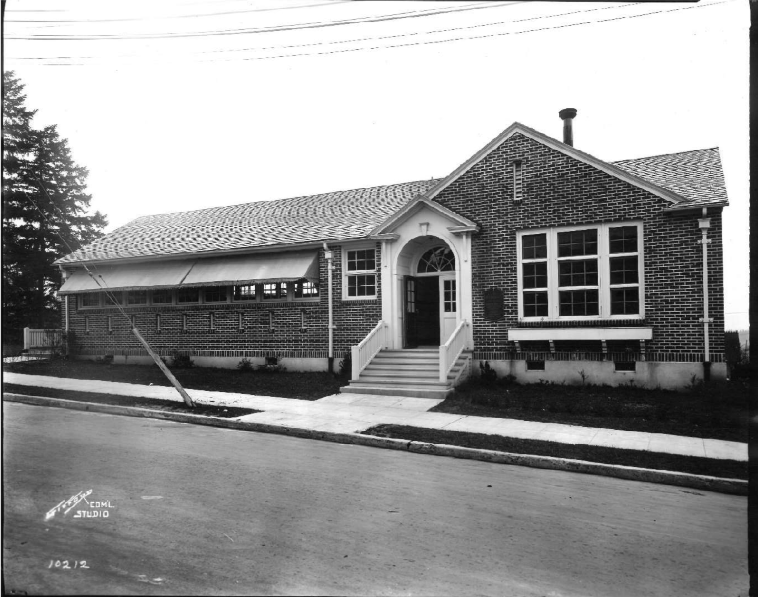
SE 60th elevation of the A.L. Mills Open Air School, built for “low vitality” children in 1919. Photograph Courtesy of the Oregon Historical Society, from the Ben Gifford Collection Box 8, Folder 5.
You’ve driven by this little jog in 60th and maybe looked at the 106-year-old building—now surrounded by cyclone fencing—and wondered about its history. Empty now since 2019 and owned by the Portland Housing Bureau, the building will soon be deconstructed and the site repurposed for affordable housing.
In the meantime before the building is gone, both the Housing Bureau and the Mt. Tabor Neighborhood Association wanted to collect and share stories about the role the old school has played in neighborhood life, and to offer neighbors a chance to come take one last look. They reached out to us for help, which has allowed our customary deep dive for stories and insights that bring the building to life, at least in our imaginations.
The east classroom at the A.L. Mills Open Air School in the early 1920s and today. Early photo courtesy of the Oregon Historical Society, from the Ben Gifford Collection Box 8, File 5.Current photo by author.
These last three weekends, we’ve led tours to share these stories, which will culminate in a final open house and tour on Saturday morning, December 7th from 10:00-Noon. Here’s a link to more information.
Later in December here on the blog, we’ll devote a full post to the stories and photos we’ve uncovered about the school and the site, but for now a short summary would go like this:
Built in 1918-1919 as Oregon’s only school entirely devoted to being “open air” throughout the school year, which was thought to be healthful during the rise of tuberculosis and other diseases. Children studied, played, ate and napped in the open-air classrooms, which were defined by their large banks of windows. The students were issued special warm clothing and monitored closely by a school nurse who also coordinated one-on-one with families on menu planning and other behaviors to help children return to vitality.
In 1949, after 30 years as an open-air school, the building was repurposed as an annex to the burgeoning nearby Mt. Tabor School. An additional classroom was built and until the early 1970s, the site hosted baby boomer kindergarten and first grade students who went on to Mt. Tabor School.
After the school function ended in 1973, the building was repurposed again as the home of a community arts and theater program run by Portland Parks and Recreation. Budget cuts in the early 1990s ended those programs and the property was on track to be sold to a private owner before being repurposed again and leased by Portland Parks to the YMCA which operated it as a daycare until 2019.
Portland Parks surplused the property in 2016 to the Portland Housing Bureau. The YMCA daycare operation ended in 2019 and the building has been vacant since then. Today, the Housing Bureau is readying the site for redevelopment as affordable housing.
Just to add a little more depth, before the Open Air School, the site hosted an imposing two-story bell-towered wood-frame elementary school between 1880-1911 but it burned in January 1911. Before that the site hosted the area’s first school, conducted in a frontier log structure. Plus, that corner of SE 60th and Stark was the center of the vibrant Mt. Tabor community before being annexed into Portland in 1905.
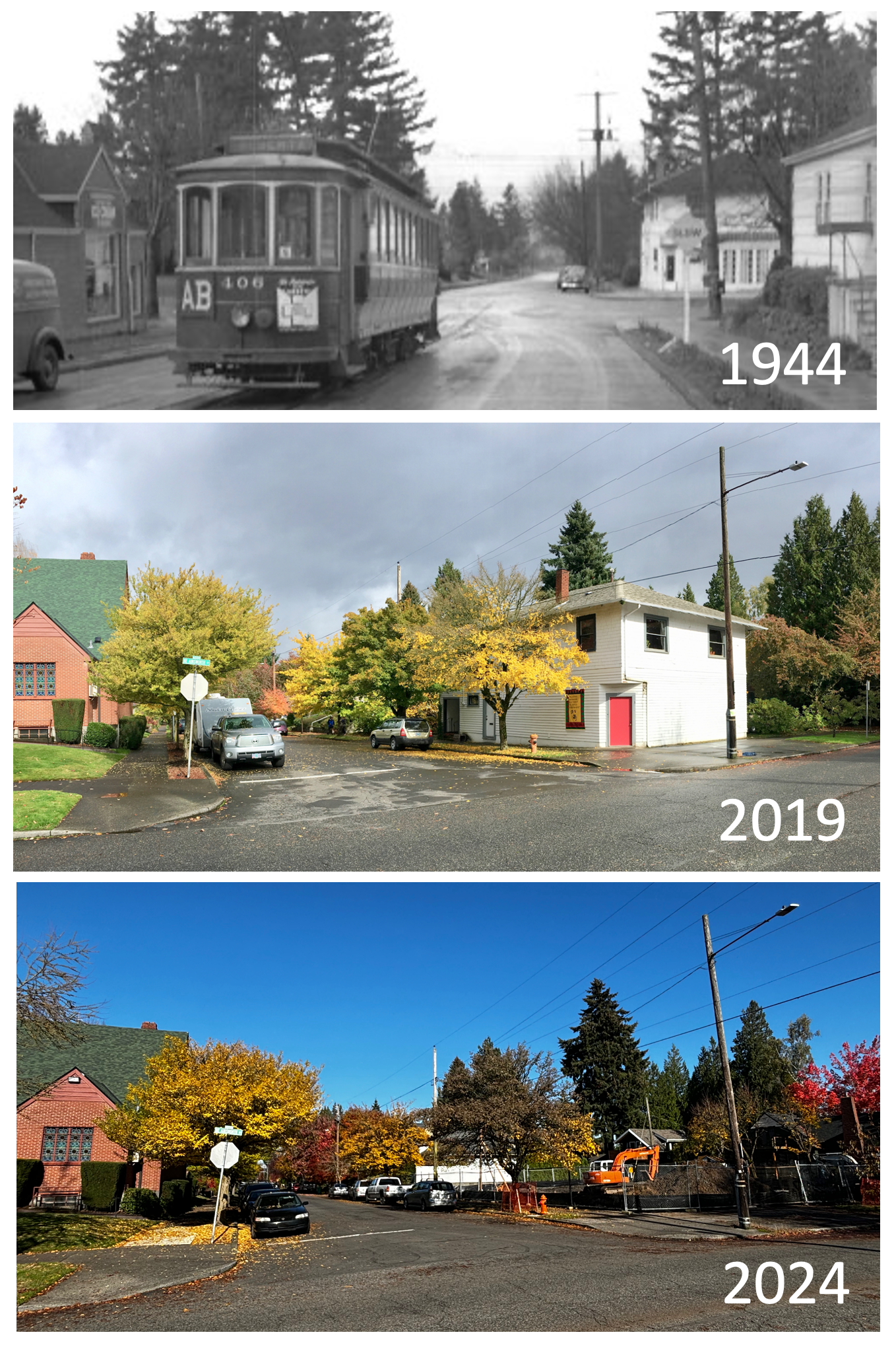
The former 101-year-old Hinrich’s Grocery building, at the northeast corner of NE 30th and Ainsworth, has been demolished recently to make way for a 14-unit townhouse on the lot.
We came upon the change while walking, and were reminded of photos we’ve taken at the corner before, and a photo from 1944 that shows the building and the north terminus of the Alberta Streetcar.
We’ve written about this corner before, which was dubbed “the finest corner in Concordia” back in 1915, following a summer evening’s soiree of dance, music and trees sparkling with electric lights.
The 1944 photo shows a corner entry and what looks like French doors that open out onto Ainsworth. We’ve been in the neighborhood since the late 1980s and that south wall of French doors during our time has always been covered over with siding.
Over the years, the building has housed many businesses, including the Mauser-Lamont Insurance Agency, Town Mart Cleaners, Emerson’s Grocery (1930s), and Hinrich’s Grocery (1920s).
Development permits on file suggest the now-vacant lot will be developed as a new 14-unit townhouse in two buildings with no garage.
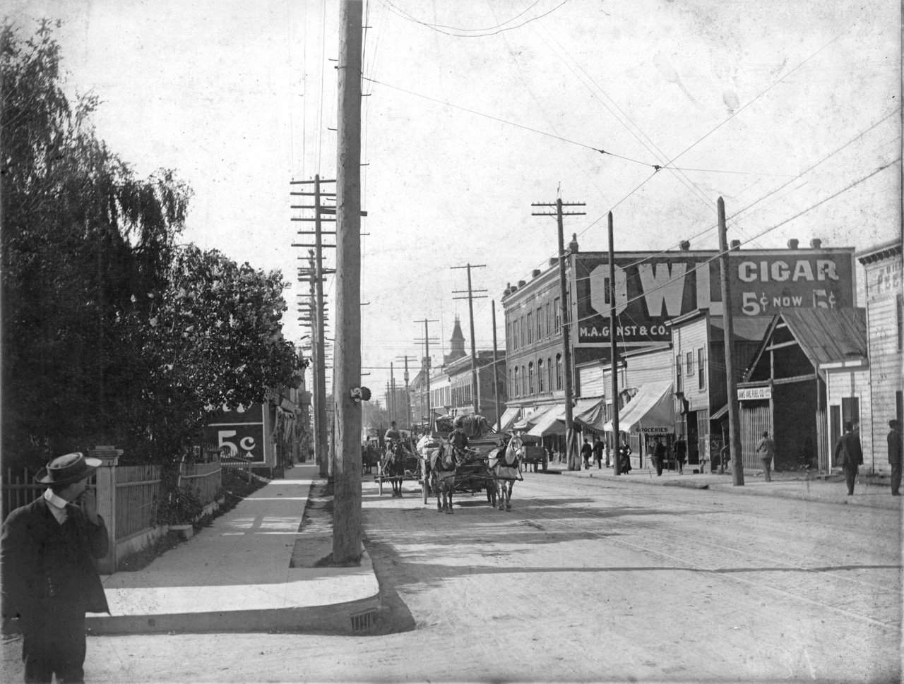
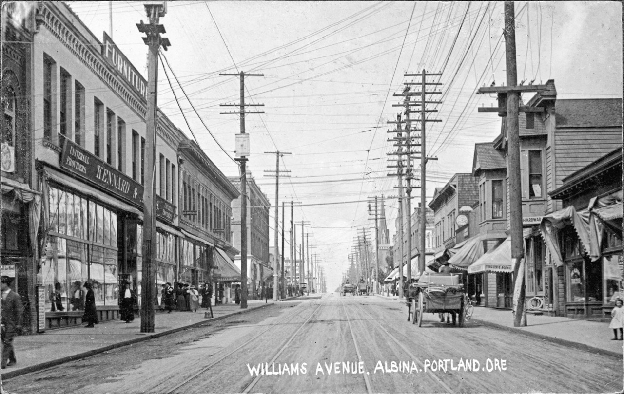
We’ve come across another outstanding early 1900s vantage point from Williams Avenue that you’re going to want to see (thanks Norm). This one is a nice southward-looking companion to the northward shot we featured a few months back. Be sure to study both and to take a good look at the Sanborn we assembled to get a feel for this long-gone place that was once a hub of activity for this part of Portland.
First, have a good look at the south view; then check out the north view that we’ve seen before. Then let’s discuss.
Looking south on Williams Avenue from Graham. Photo courtesy of Norm Gholston.
Looking north on Williams Avenue from Russell. Photo courtesy of Norm Gholston.
What do you see?
Let’s start by looking at the northward image, where you can just about see where this southward view was taken. See the picket fence that appears below the steeple of the Immaculate Heart Church and the bushy tree? Nearby, check out the utility pole that is leaning toward the street.
Now, look at the southward view: there’s the picket fence and the bushy tree behind our man in the hat scratching his face (and the leaning utility pole). That should help put things in perspective and establishes the photo was taken from the corner of Graham and Williams.
The crank on the pole (you can see others like it in the northward photo) allows for periodic maintenance of the carbon arc streetlight hanging overheard.
Look how fresh and clean those curbs and sidewalks look. Chances are they were built by Elwood Wiles, a household name you can still see today stamped into sidewalks all over the eastside.
The Willliams Avenue streetcar tracks owned the middle of the street, with streetcars headed north/south to St. Johns, which were shifted over to Union Avenue about 1911. No automobiles to be seen.
Look at all the awnings: in the southward photo shading the west side of the street from morning sunlight (and it might still be somewhat early judging on the length of the shadows that spill out into the street).
Check out the onion-shaped dome from the old Hill Block building at the corner of NE Russell and Williams, which can be seen today in Dawson Park. That intersection was the center of the universe for early Albina and a crucial part of the African-American cultural landscape well up until when it was torn down in 1969. That block has been vacant ever since, but planning conversations are underway.
The loss and complete transformation of what was once a vital Albina main street will always haunt this North Portland neighborhood, in so many different ways. Important chapters of Portland history have played out here, from the early days of being its own city before becoming part of Portland, through waves of immigration, to Civil Rights protests and the vibrancy of African-American owned business, life and culture.
Today, if you don’t know this history, you might drive north on Williams past Emanuel Hospital and not know you are traveling through a kind of sacred ground.
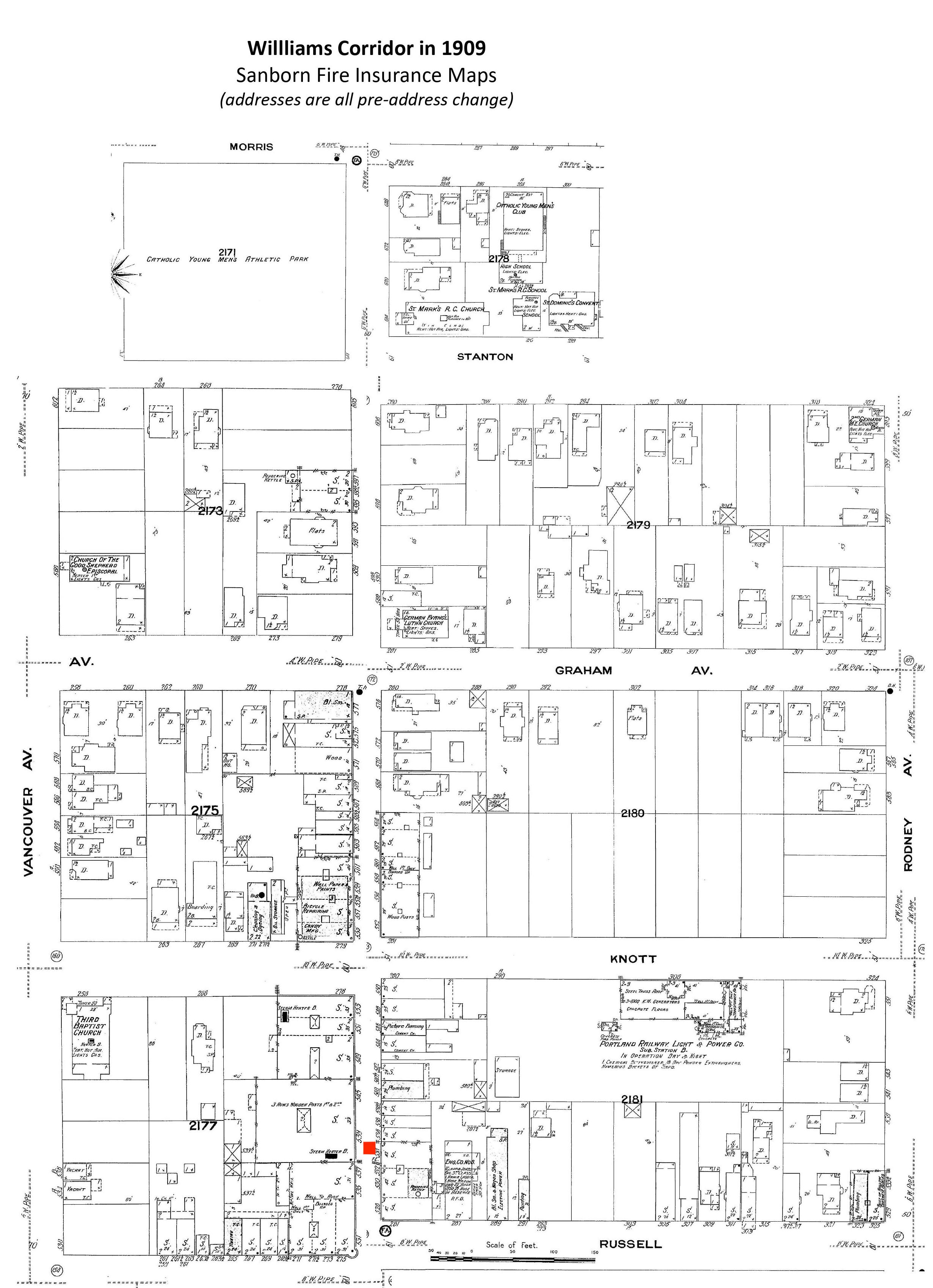
To help us imagine this lost place, here’s a pretty amazing photo from AH photo friend Norm Gholston, and a then-and-now shot we matched up during a recent outing. Norm shared this great old pic recently: it’s the image side of a “real photo” postard, popular in this era. Click to enlarge and take a good look.
Taken from just north of the intersection with Russell Street, the 1909 photo features a look at the Kennard and Adams department store on the left, which carried a little bit of everything. The first intersection in the distance is Knott Street. That’s the Immaculate Heart Church steeple at Williams and Stanton you can see in the distance, the only common denominator that really jumps out at you from the two photos (known back in the day as St. Mary’s Church, not St. Mark’s as the Sanborn implies).
Here’s a composite of several Sanborn maps we put together to be able to visualize where Norm’s 1909 photo was taken. The red box indicates the approximate photo point. Click to enlarge.
Details from Sanborn plates 268, 273 and 274, from 1909.
If you ride, walk or drive this way—or if you didn’t know the history of this amazing stretch of street—take a moment to check out the following multiple sources of insight about what this neighborhood meant during its heyday, and how its loss has affected the people who knew it:
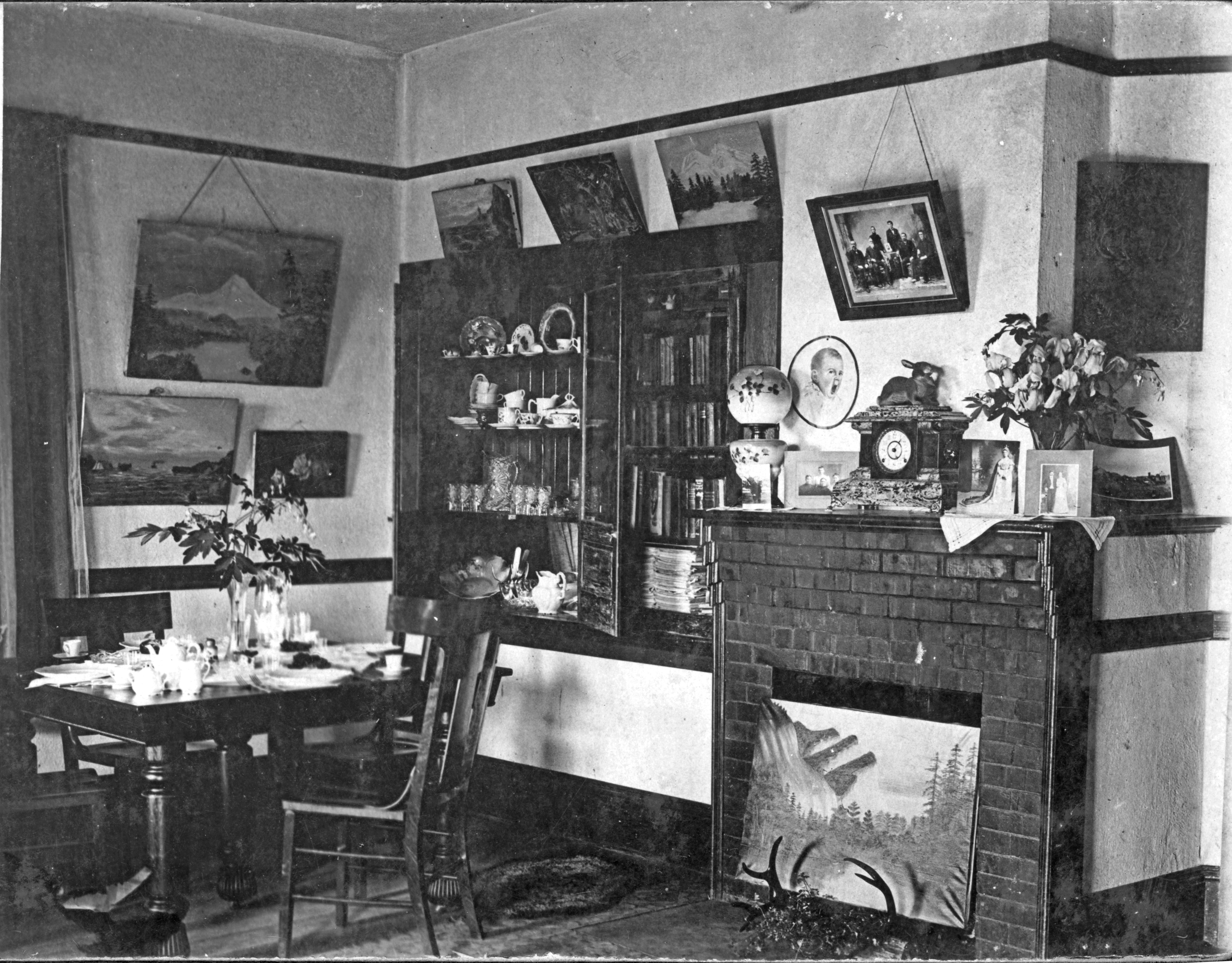
It’s been a quiet year so far on the AH blog, in deference to a busy batch of research for home owners and architects, several presentations, and ongoing exploration of our standing lines of history inquiry. We’ve been saving up some favorite old photos sent our way by history friend and photo collector Norm Gholston. Here’s one you’re going to want to take a close look at: the interior of a home in the vicinity of North Albina and Webster just after the turn of the last century.
Click in for a good look and then let’s take it apart in the way we like to do with Norm’s great old photos.
Part gallery, part living room, part library, apparently part dining room, this room is dressed to the nines. These picture rails are fully engaged with local art: Mt. Hood, the Coast, maybe the Columbia River.
The mantlepiece tells multiple chapters of the family story and serves as home for the heirloom clock (and the rabbit). Our very favorite thing in this whole picture is the yawning baby on the wall.
Formal table setting, with two forks at each plate, cloth napkins, the good china. Are the flowers silk or the real thing?
The texture of the plaster—and the various cracks and wear marks—make us think this house has seen a few years. And interesting fireplace: we’ve never seen a wooden fireplace surround quite like that one with corner trim that steps back following the line of bricks.
Bookcases filled. Thin carpet. Painted antlers. Victorian parlor lamp. So much to see.
The actual location of the house remains a bit of mystery. Norm tells us that on the back of the photo is written the address “5021 N. Albina,” which is curious for several reasons:
The address format is post-address change, meaning someone wrote that on there after 1931, which certainly could have happened. But the photo appears earlier than that to us.
The current building at that address is a mid-century brick duplex at the southwest corner of N. Albina and Webster…definitely not this place.
A look back at aerial photography of that corner in 1939 and in 1925 shows a vacant lot, as does the 1924 Sanborn map.
Could be that this is the interior of a house that stood there but was demolished before the 1925 aerial photography, but why would someone write 5021 Albina on the back given that it was never known as 5021? Hmm.
So we’re glad to consider this the interior of a house in the neighborhood from the turn of the last century and leave it at that. One of those mysteries that may never be solved. We like to solve them, but we’re glad just to continue contemplating too.
With thoughts about snow in the air, let’s turn back the clock to 1911.
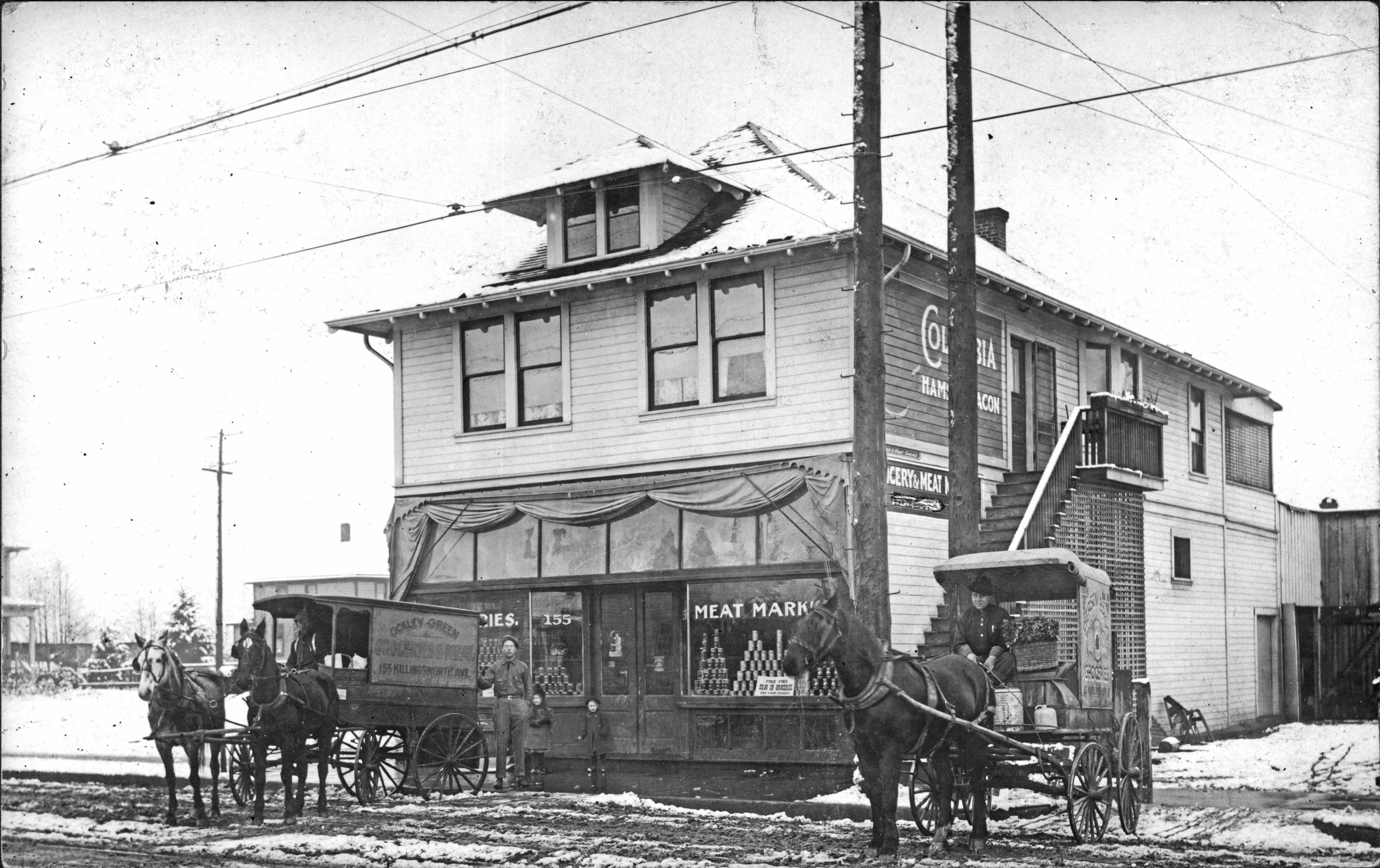
From time to time, AH reader and Portland photo collector Norm Gholston sends along a gem or two from neighborhoods we know well—and some we’re still learning about. Here’s a killer image Norm shared recently, a “real photo” postcard from 1911 that shows a mom and pop grocery from Killingsworth Avenue at the southern edge of today’s Arbor Lodge neighborhood.
There’s so much to see and think about in this photo. Click in for a good look and we’ll share some insights:
Photo courtesy Norm Gholston
Snow! Those four-legged traction devices look pretty steady, don’t they?
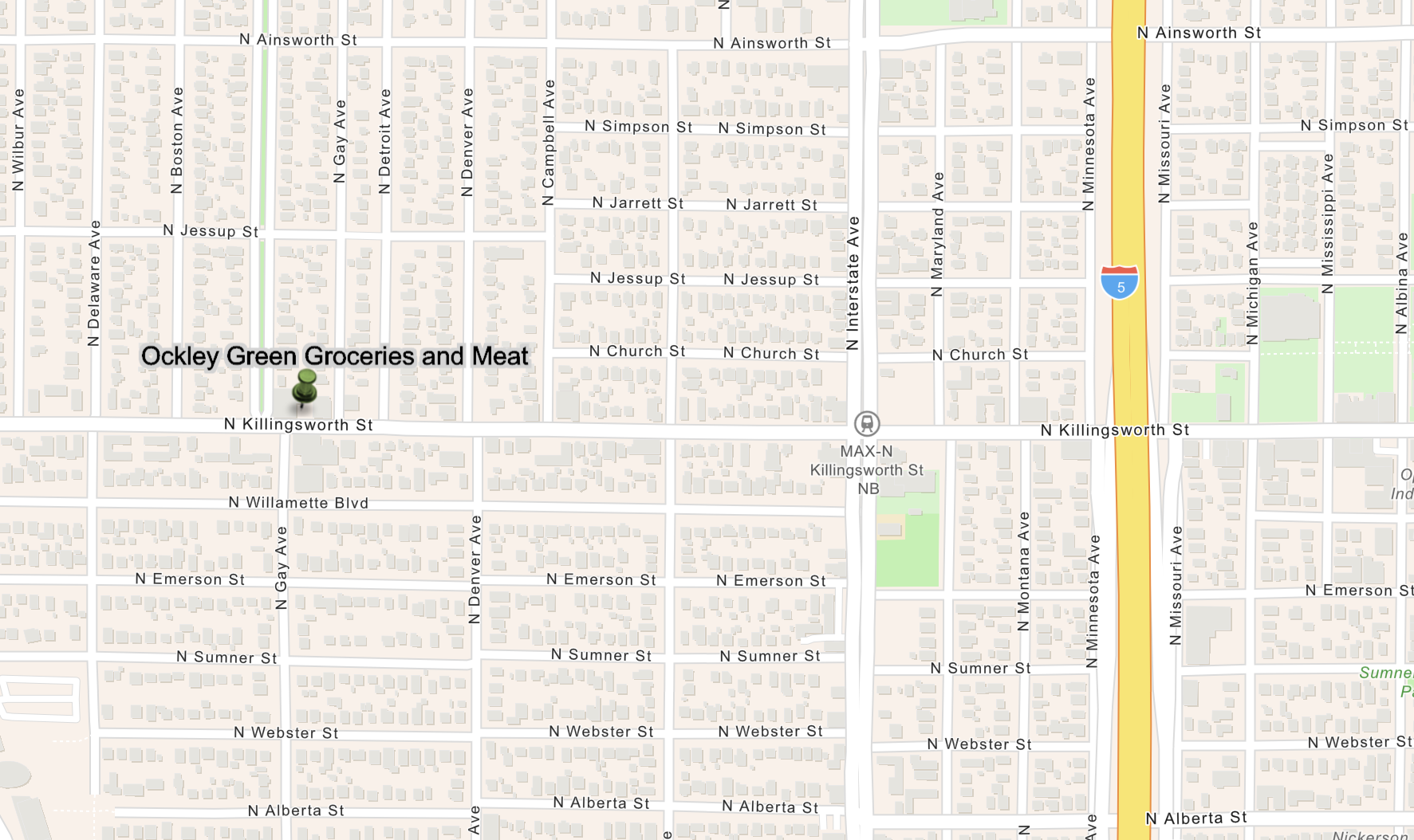
As the writing on the wagon to the left says (and the numbers on the window to the left of the front door suggest), this is 155 Killingsworth Avenue, which before Portland’s Great Renumbering was actually 155 West Killingsworth. When you map that out today, it takes you to 2225 N. Killingsworth, located on the north side of the street just east of the N. Omaha Tree Way, a four-block-long Arbor Lodge boulevard.
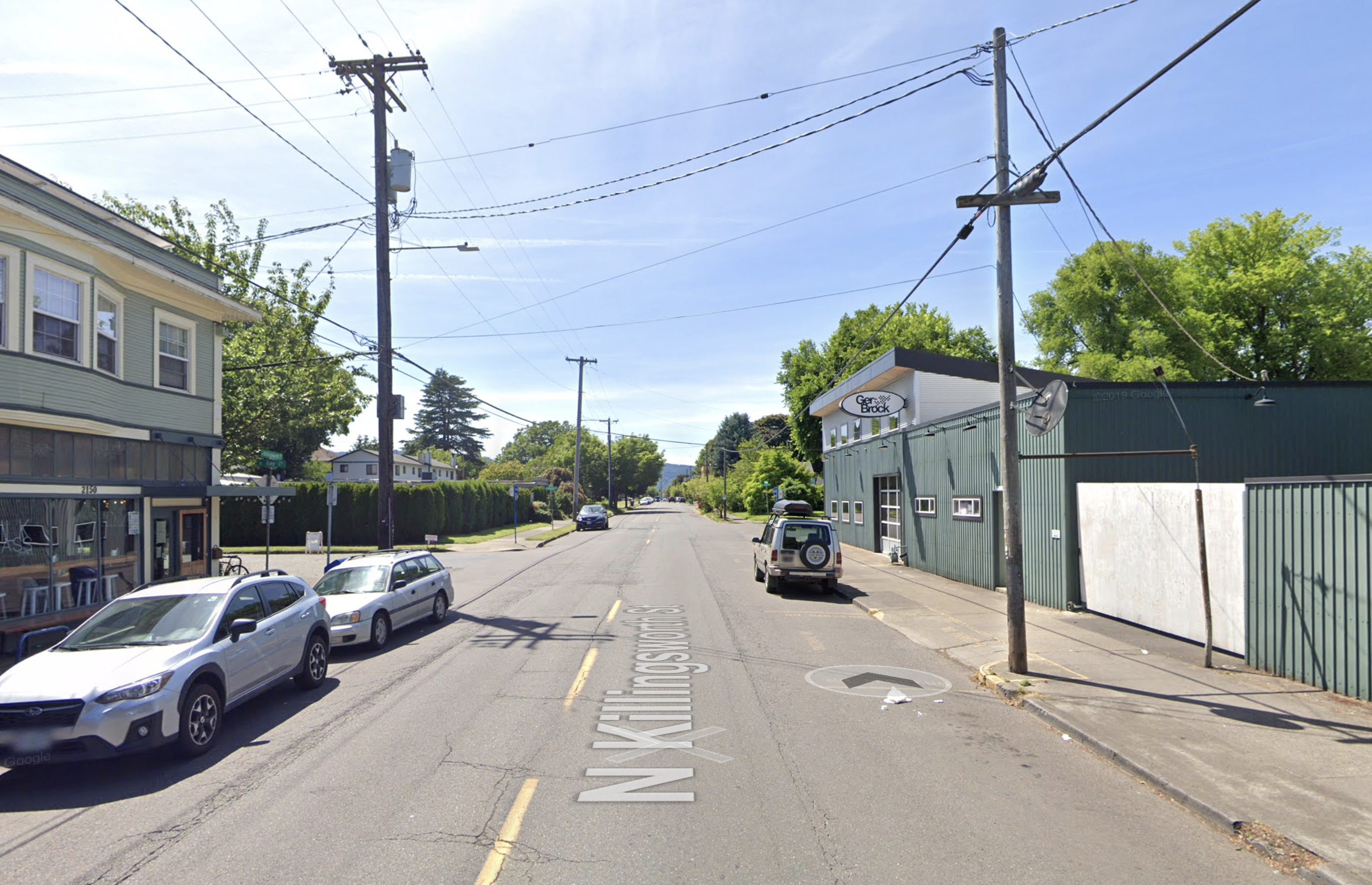
Here’s where this is today, first by map, and then by Google Streetview
In this contemporary Google Streetview image, the horses and wagons would be parked near the utility pole in front of the white gate.
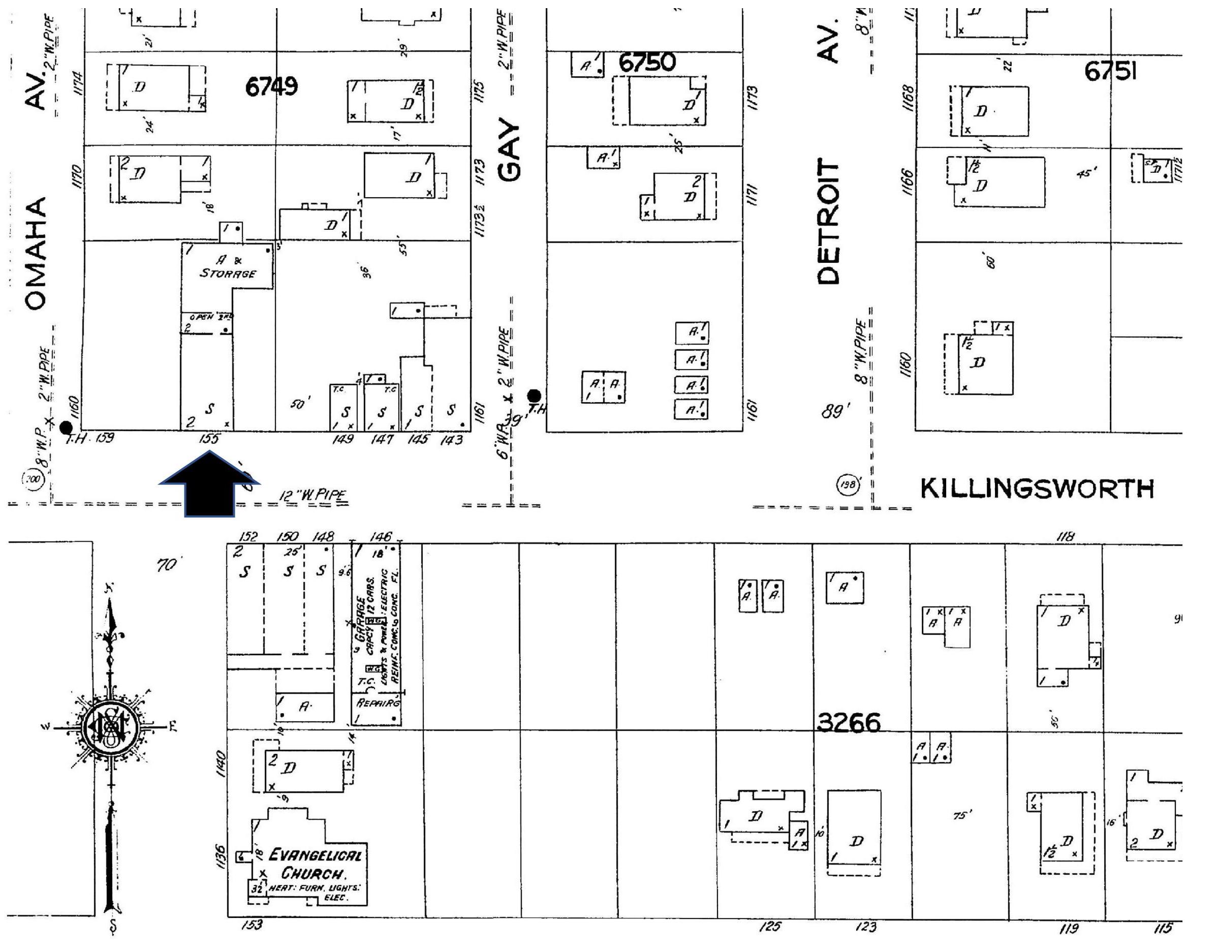
Detail from Sanborn Plate 521 shows the area in 1924. Arrow indicates location of Ockley Green Groceries and Meat.
Interestingly enough, there must be some remnant of the old market building underneath the existing structure of the auto shop that exists at that address today, because a plumbing permit still on file for that address tracks back to construction of the market building in July 1909, and tells us it was indeed a store.
The wagon on the right, with the grinning driver in his great gauntlet gloves, buttoned-up tunic and basket of greens, is driving for Pierson Brothers Grocery, also housed at 155 W. Killingsworth (look very carefully at the writing on his wagon). What was in that drinking jug on the far right next to the kerosene can?
Neither the Pierson Brothers nor Ockley Green Groceries and Meat appear in any of the Polk city directories either side of 1911 when this photo was taken, but don’t tell these guys that. We’ve scoured through newspapers and other business listings of the era and don’t find reference to these businesses either, though the grocery operated for years after the photo was taken. Help wanted ads from 1910 sought an experienced meat cutter to come in on Saturdays. Perhaps that’s when the fresh meat arrived from the nearby Portland Union Stockyards.
Be sure to appreciate the school girls: the younger girl on the right pulling a sled; both are layered up in their wool coats and hats and good winter boots.
Some clever volunteer editor has scratched out the words under the sign near the stairs, readable between the two utility poles. Yes, we can read “Grocery & Meat Market.” No, we can’t read whatever you crossed out. Was it a person’s name? The scratch-out edits were applied directly to the postcard, not to the actual Foster and Kleiser sign. Why?
Thanks to the 1910 census, we know who is living up those unpainted stairs, behind the open screen door. It’s Frank B. and Margaret Ford, who built the building. Ford was a real estate speculator dealing primarily in grocery stores like this and other simple first-floor commercial properties. Frank and Margaret bought and sold many properties on the eastside over the years and when things got tight, Frank took some liberties with certain documents, which got him arrested in 1929 for real estate fraud. But in 1909, he knew the right place to build a market with the new and booming Overlook neighborhood all around.
Frank B. Ford and his partner Theil also built the commercial block across the street which now houses the Milk Glass Market (which is well worth a visit by the way for a coffee and look around at the neat old market building insides). Back to the photo, look carefully at the reflection in the market window panes and you might even be able to make out the form of the building across the street and its clapboard siding. Check out the Sanborn plate again (and the streetview) and you can see the Milk and Glass Market building directly across the street.
Be sure to note the rails running east-west on Killingsworth, visible in the far left bottom of the photo. This is the St. Johns car line. In the 1890s, somewhere nearby behind the photographer was the re-load point where the steam train came and went to St. Johns and riders transferred to the electric trolley line that ran east and then south toward Portland. A station was built here–at the corner of Killingsworth and Omaha on the south side of the street–and it was called the Ockley Green Station; later it served the electric trolley that went all the way through to St. Johns. You’ll find dozens of references to it in early newspapers of the day. Real estate ads selling houses or renting apartments all say “near Ockley Green Station.” No need for an address or even a cross-streets, everyone knew where Ockley Green Station was (though, thankfully, some did explain Omaha and Killingsworth was the spot).
There’s another mystery we’ve been puzzling over that will remain unsolved for the moment (we’re not without our hunches): the name Ockley Green taken by the station and the market, and eventually the school.
Here’s what we know for sure:
Ockley Green was the name of the station from early days. It was not named for a person. There is no person in any of the Portland decadal censuses during that time or in any city directory of that era that we examined with that name.
The school that exists today at Ainsworth and Interstate (10 blocks to the northeast) built in 1925 takes its name from the Ockley Green Station. Documents from the Portland Public School archive tell us this fact. The original building was actually built as “Multnomah Public School” in 1893 at N. Missouri and Shaver, but was moved to Interstate and Ainsworth about 1901, and its name changed to Ockley Green (for the station) in about 1909. The first building was demolished and the one we know today built in 1925. But that’s another story.
There is no underlying plat or development plan with this name, no streets or other features. It was more of a “district” than a specific place.
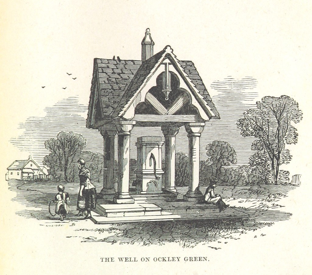
Ockley is a picturesque town in Surrey in southern England with a much-written about commons or “green.” Even today, Surrey’s heritage authority reports the most important feature of little Ockley town…”is the long, broad green, which is said to be one of the most impressive in southern England.” Both the green and the town were celebrated in writing and in art during the 1800s. Here’s an example:
From London News, 1851.
We’ve had a good look around on this naming mystery, talked to the Arbor Lodge Neighborhood Association, consulted all of our usual helpful print and public document sources and even stumped a few research librarians. The definitive story behind origin of the name Ockley Green has apparently slipped away, at least for the moment. We have our hunches: immigrant Portlanders with roots in Surrey saw something about the open landscape of the early neighborhood that reminded them of home, and it was comforting to have the place and the memory with them. We completely understand this.
Meanwhile in 1911, it was snowing at 155 West Killingsworth and the grocerymen were still delivering, the kids ready for adventure.
We’ve been watching two commercial corners just a few blocks apart that share similar histories but are on very different pathways to the future.
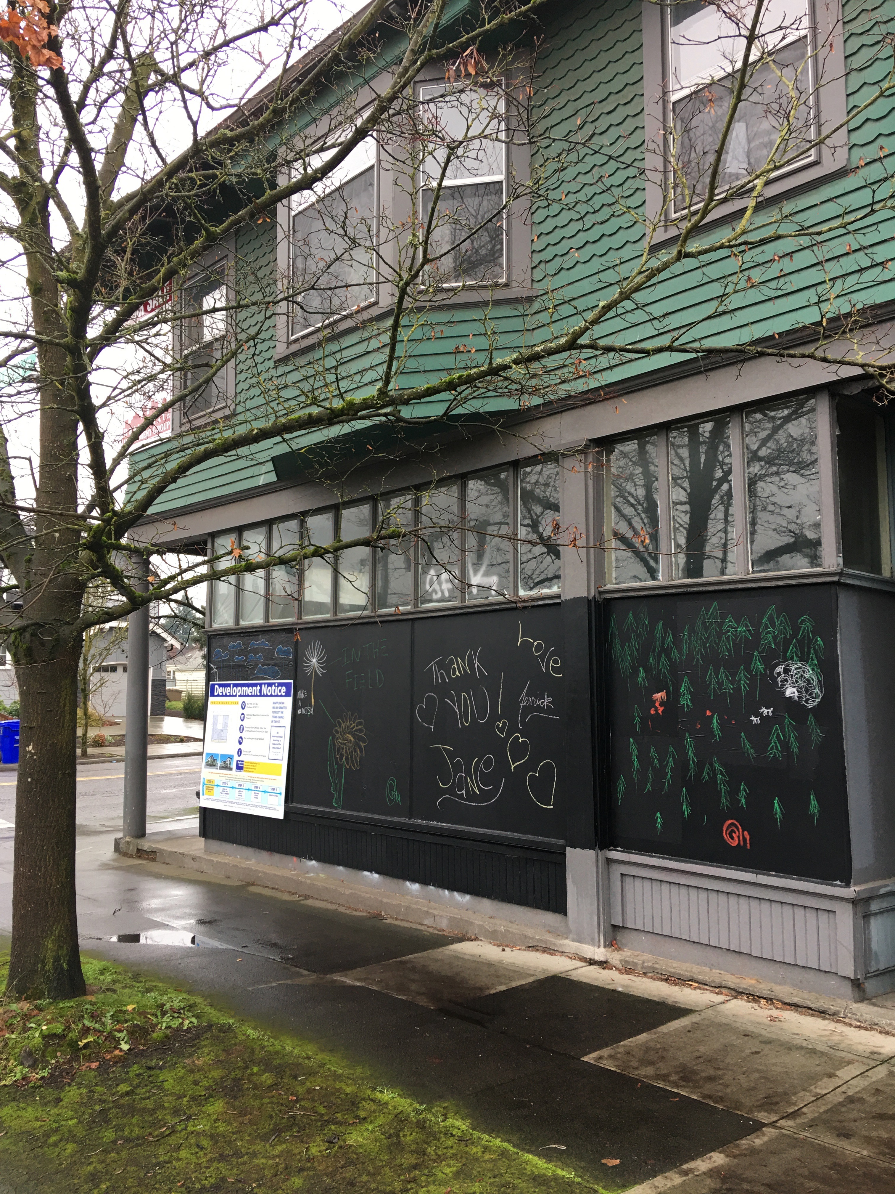
We’ve written here about the Logan Grocery, the mom-and-pop grocery store that for more than 100 years has anchored the southwest corner of NE 33rd and Alberta and is now slated for demolition. Here’s a look just as a refresher:
NE 33rd and Alberta, December 2019
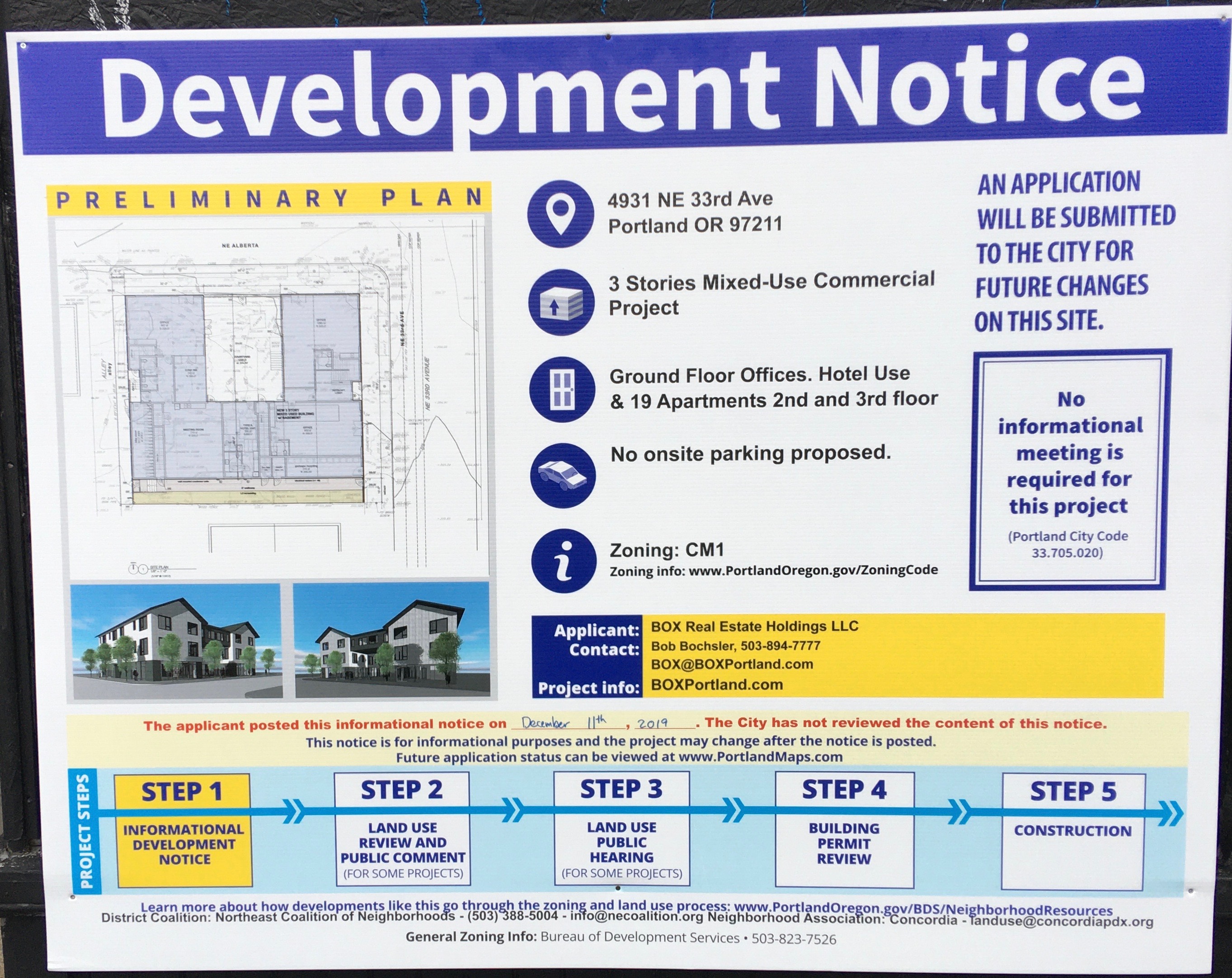
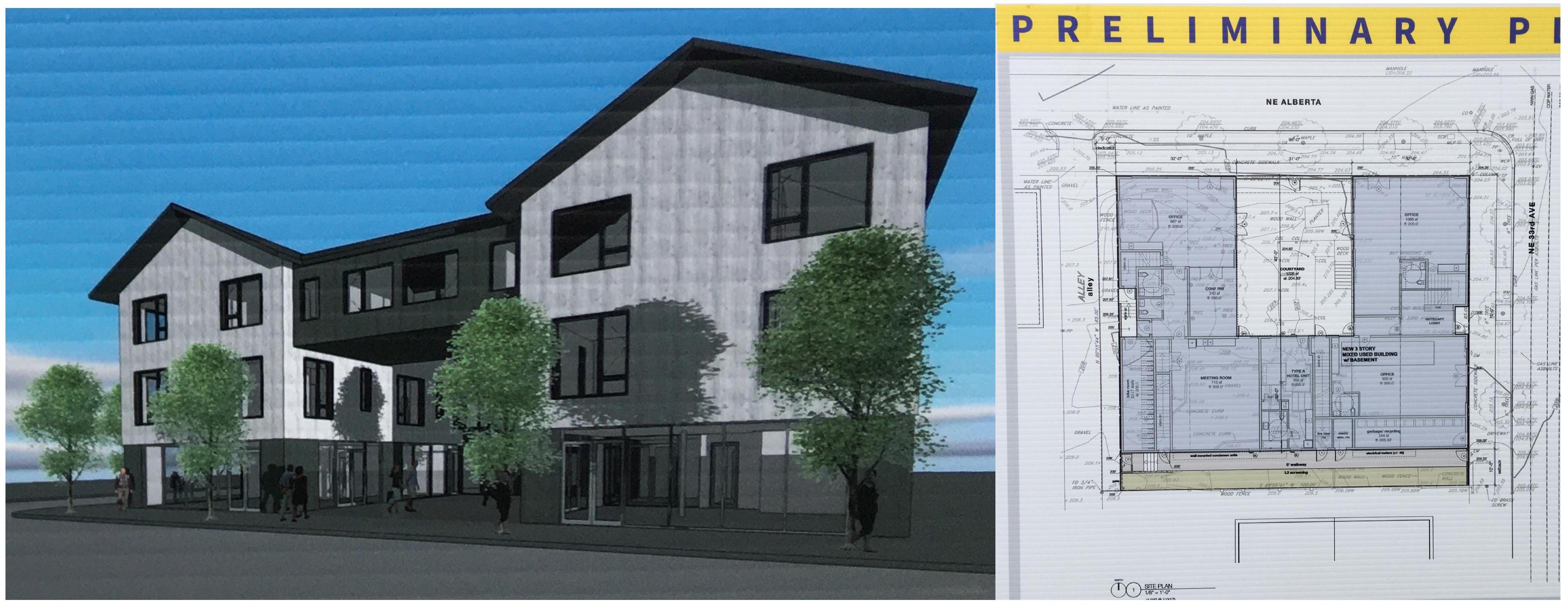
In the last week or so, a sign has been posted on the building showing a rendering of the future, which includes demolition of the historic building and then construction of a three-story mixed-use commercial building including a 19-apartment hotel (which we think probably means Airbnb-like short-term rentals) and no on-site parking. Yes, you read that right. Take a look (click to enlarge).
Interviewed in late September, developer Bob Bochsler of Box Real Estate Holdings explained that he wanted to consider ways to utilize the existing building, but that concerns associated with the cost of reinforcing the old foundation drove the demolition decision, nixing any kind of adaptive reuse that would allow the existing building to be repurposed for a new future.
Note that no informational meeting is required for this significant change, though there is contact information and a cryptic note that the project might be amended.
~
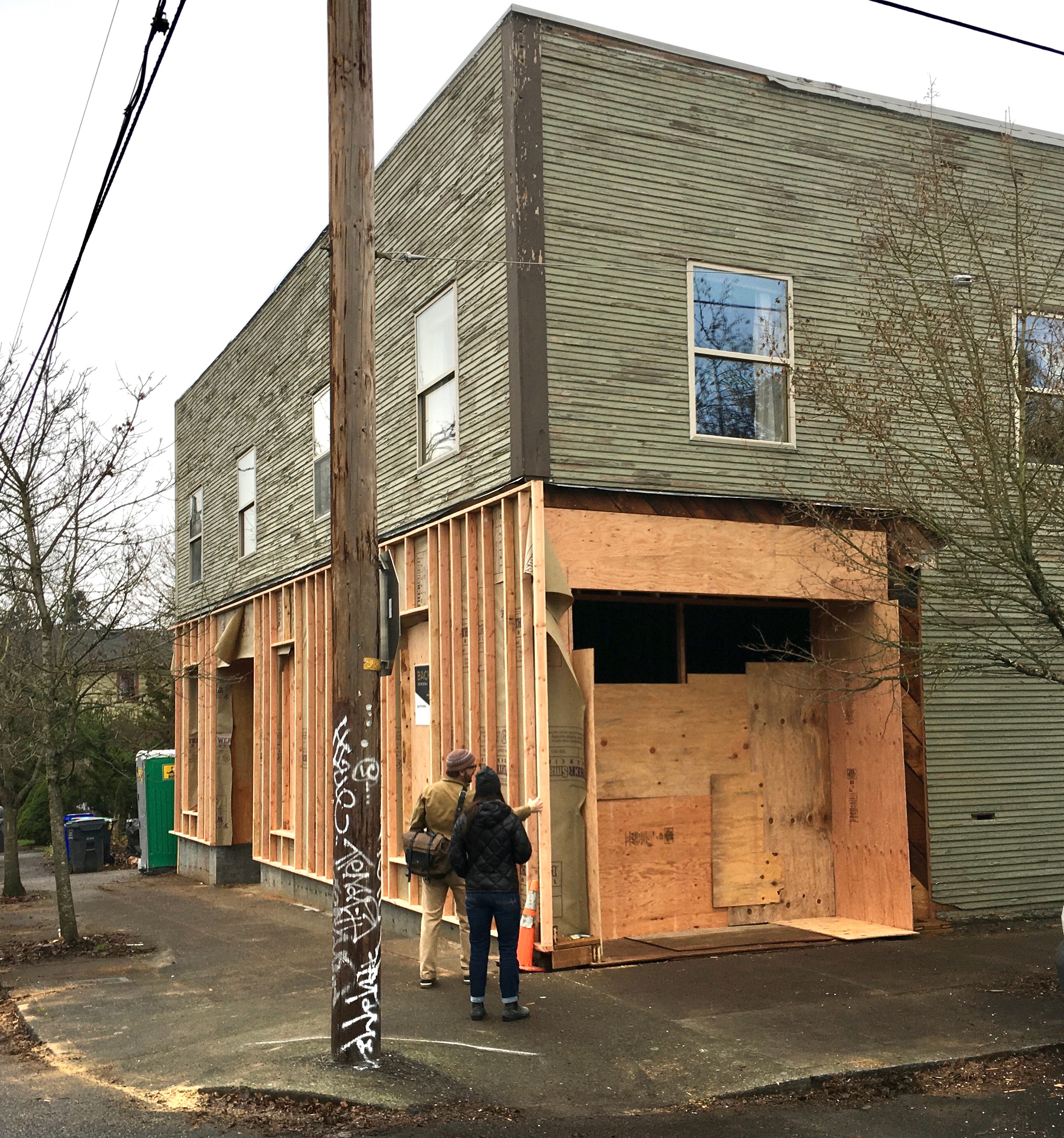
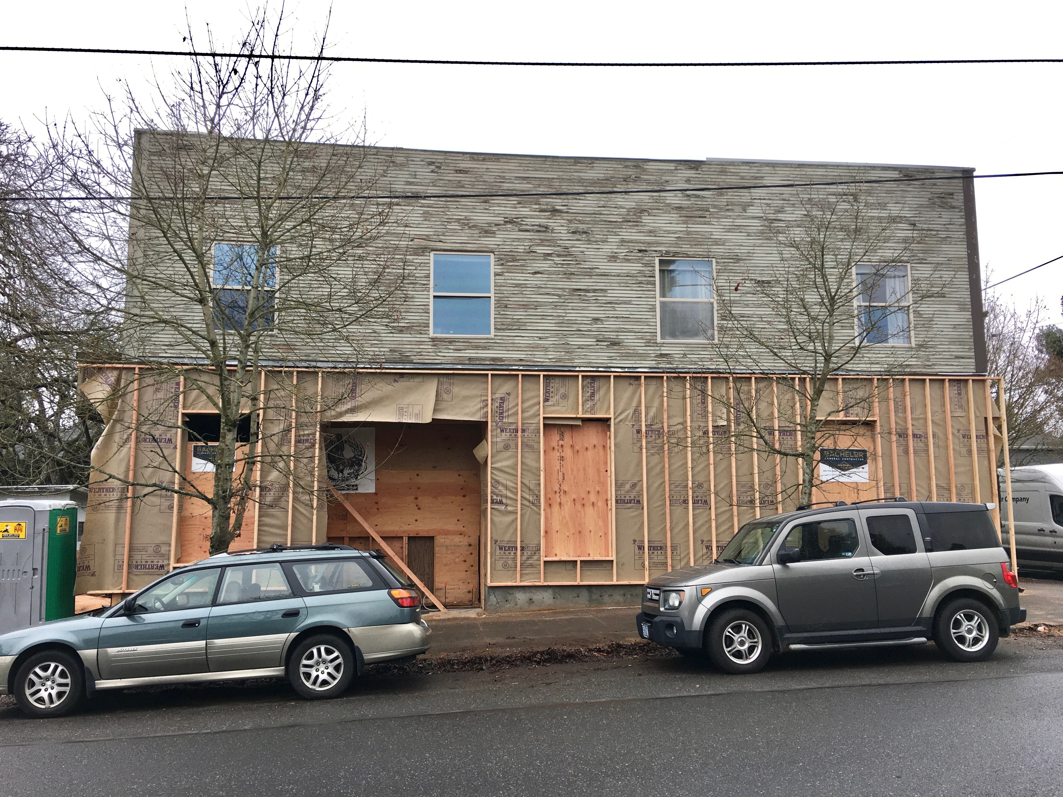
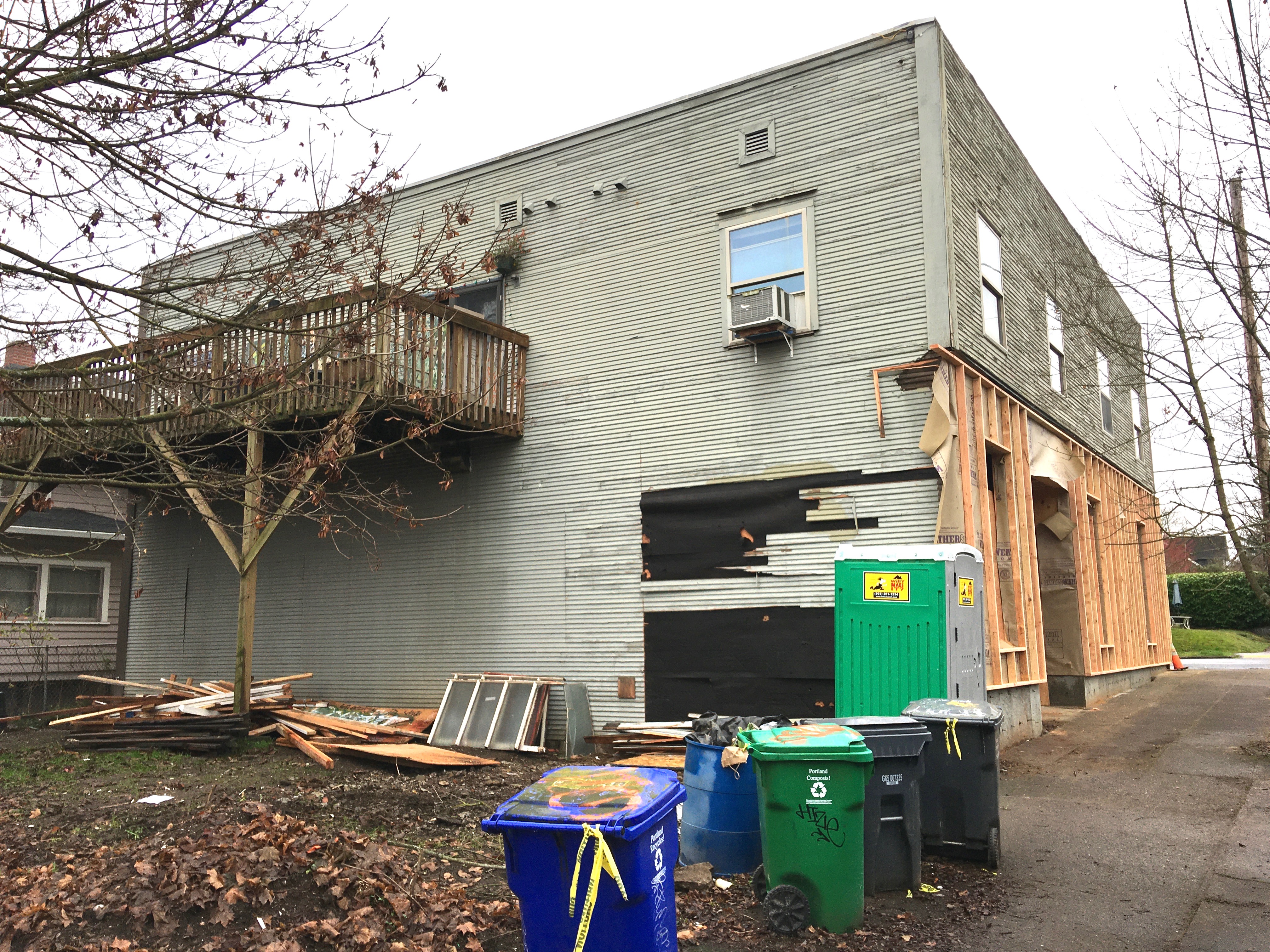
Meanwhile, A few blocks over, at the northeast corner of 30th and Emerson, a similar but very different story is unfolding. Here, a 107-year-old wood-frame mixed-use commercial building that was once also a grocery store (and many other things) is being restored and repurposed as the home of a medical practice and neighborhood coffee shop. Take a look:
Dr. Thomas Grace and Rachel Buckwalter inspect the southwest corner of their future place of business. Clinic entry to the right, coffee shop entry to the far left. December 2019.
West side, coffee shop to the left, clinic to the right. Apartments upstairs. December 2019.
There’s lots more to learn about this old building, constructed in 1912, which once housed two businesses on the first floor facing NE 30th, and two apartments upstairs. Back in the day it was a grocery store. It’s been Cecilia’s Drapery Shop, Jack Emerald’s Barber Shop, The Quaint Shop (an art supply business), a men’s clothing shop, a dry goods store and many other things.
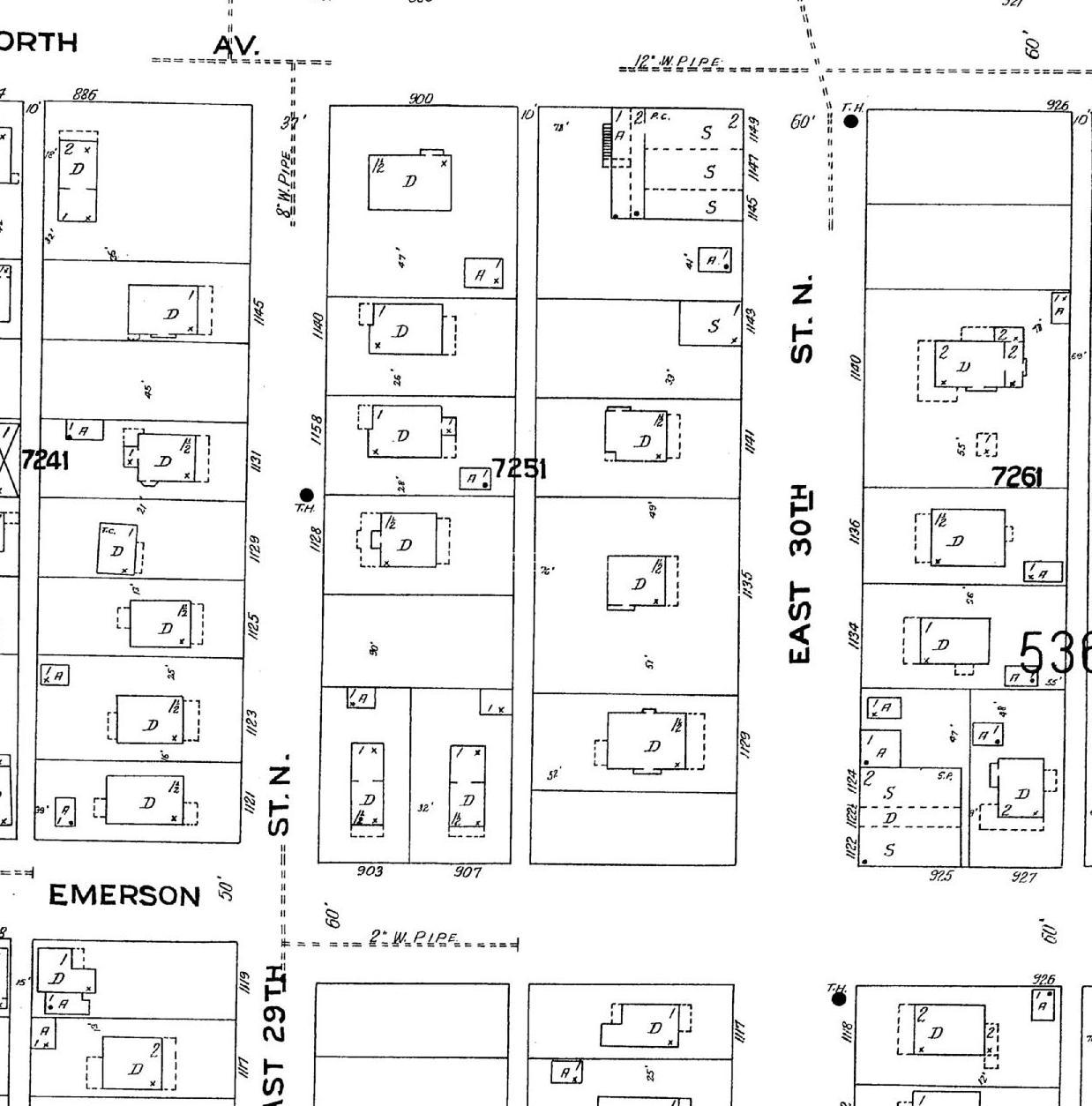
Here it is in the 1924 Sanborn Fire Insurance map, showing it’s pre-address-change addresses of 1122 and 1124 East 30th Street North (downstairs) and 1122 ½ (upstairs). Look in the lower right-hand corner. S=shop. D=dwelling. A=automobile or garage.
Detail from Sanborn Fire Insurance Map Plate 535, 1924.
Dr. Thomas Grace and Rachel Buckwalter bought the two-story building this last year and have been busy getting it ready for its next chapter, which begins this coming spring. The couple own and operate Natural Pain Solutions, a chiropractic practice focused on non-surgical spinal decompression, integrated care and treatment for pain. When it opens in spring, the practice will be Move Better Chiropractic.
Their former clinic had been located in the Macadam Center building which was destroyed by fire in January 2018. After the fire, Thomas and Rachel—who are Vernon neighborhood residents—were on the lookout for a new venue. When Rachel saw the for sale sign on the building last spring, she called on a whim, walked through later that day and fell in love with the building. Thomas saw it the next day and they knew renovating the space would work for them. Within weeks, they had started talking with architects.
Since then, there have been plenty of conversations with engineers, estimators, architects and contractors to determine the feasibility of adapting the building to meet their needs, but in their minds demolition was not a solution.
Yes, the foundation is 107 years old and like all old foundations in the neighborhood has its issues and needs. But instead of considering that a deal breaker, a partial new foundation wall has been added, seismic stabilization work has been done, and additional structural timber has been added.
The renovation design concept—by Portland firm Works Progress Architecture—starts with the structural work and completely renovates the interior space, fitting it inside the existing exterior building envelope, offering a contrast between old and new. The clinic and a new coffee shop will occupy the first floor, with glass roll-up garage doors in the coffee shop on the north face of the building opening onto an open outdoor patio and hanging-around space. Friends of Grace and Buckwalter own and operate Full City Rooster (a craft coffee roaster in Dallas, Texas) and will be helping Grace establish the coffee shop in the renovated building.
North side where the roll-up garage door will open into the patio/open space. December 2019.
Upstairs, the existing apartments are being renovated. In the future, Grace and Buckwalter hope to convert the two existing apartments into four studio apartments.
A repurposed small building in the open lot to the north will hold Buckwalter’s new business, “Moss,” which will feature an unusual mix of garden-related items and specialty intimate clothing for women.
The couple—who live a few blocks away in a 1912 bungalow with their four children—appreciate living and working in vintage spaces. The building is not far from the busy Foxchase corner of NE 30th and Killingsworth, and just a few blocks north of Alberta. Being on Trimet Bus 72 is also a plus (they’ve added a get-out-of-the-rain portico to the west face of the building for riders).
So, why did they decide not to go for the demolition option and to invest in making an old building work?
“We like the building and we think it will look beautiful with a couple upgrades and modifications,” said Grace. “We see this location as a natural transition between Killingsworth and Alberta Street, and hope to be a connection point in the community. We hope that the outdoor space will serve as a public area and place of informal gathering.”
It’s been a year since demolition of the old Spur Tavern and 42nd Avenue Tourist Cabins near the corner of NE 42nd and Holman. You might remember these buildings in their old age: bright green, broken down, painted over with graffiti, a little scary.
While researching them we met Mike Brink who spent some of his growing up years in one of the cabins, and also in his grandmother Ugar’s old farmhouse (now gone) a couple blocks away near the corner of NE 41st and Highland. Since that first conversation with Mike, we’ve been intrigued with his memory of walking through the open fields that are now built up neighborhoods west of Fernhill Park.
Whenever we’re over that way with the dog, we think of Mike’s open view across the fields toward Kennedy School; his every morning walk along the long block of Ainsworth to pick up the Alberta Streetcar at NE 30th and Ainsworth for the ride to St. Andrews school, at NE 9th and Alberta.
Recently, Mike sent along a few photos he came across taken out front at the tourist cabins. We thought AH readers might enjoy seeing them too, and a recent look at progress on what is now the construction site. So, have a look.
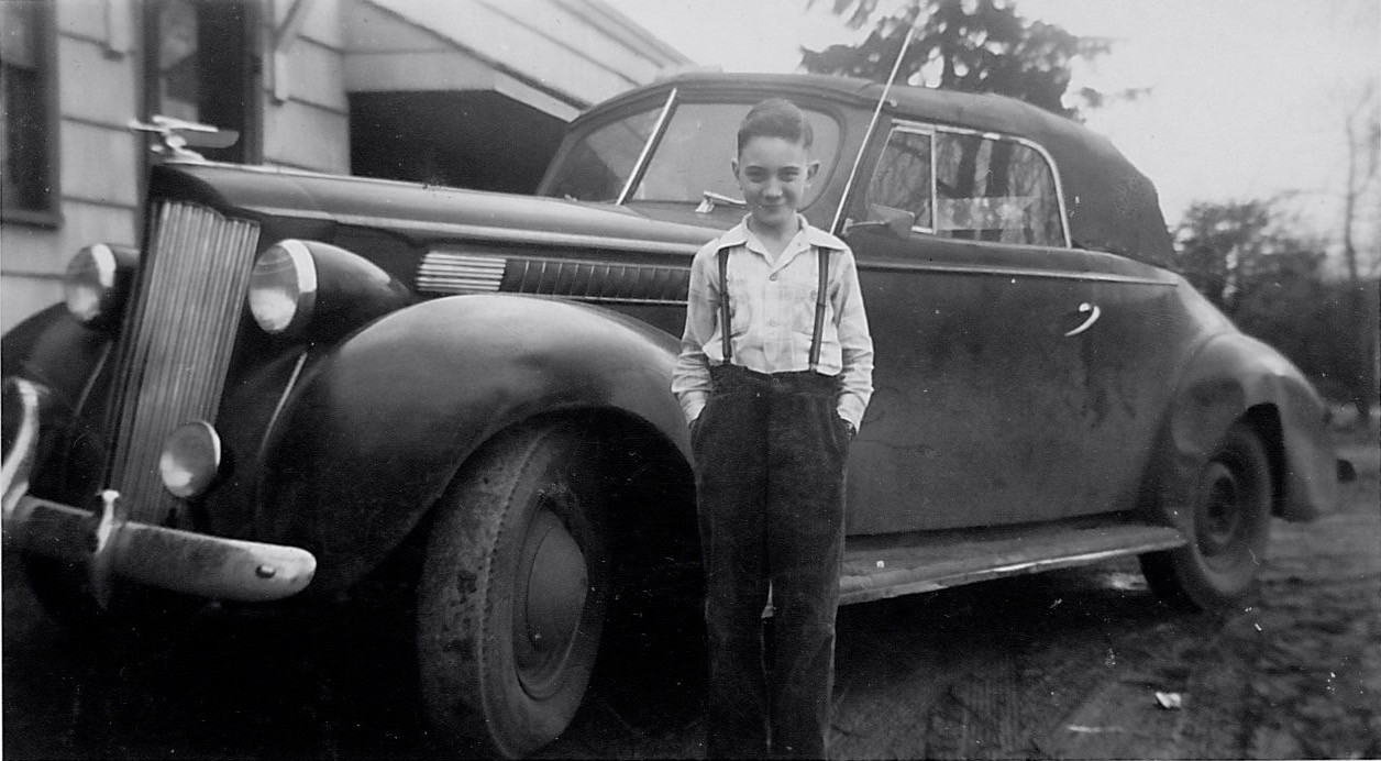
Here’s young Mike in about 1945 standing in front of his Uncle Joe’s pride and joy—a 1941 Packard convertible, parked in front of Cabin 6, behind the Spur Tavern.
Photo courtesy of Michael Brink
And here’s another: Mike’s dad, uncle and a pal in front of the tourist cabins, looking the other direction, open fields off to the north.
Photo courtesy of Michael Brink
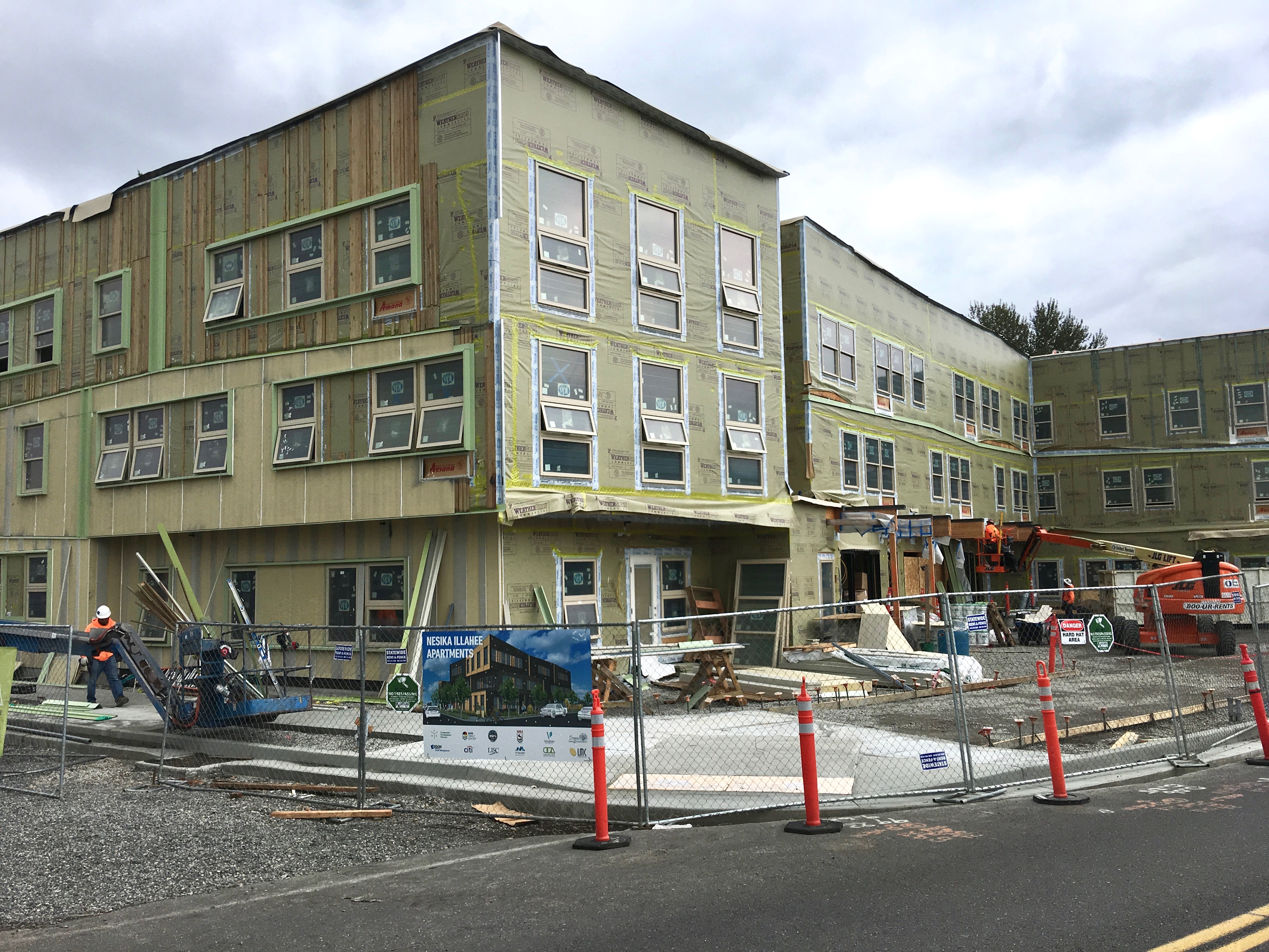
Here’s the update photo of what’s rising where the Spur and tourist cabins once stood, taken right about where Mike and his family posed for snapshots back in 1945.
Nesika Illahee Apartments, NE 42nd Avenue and Holman, October 2019
And here’s where it gets even more interesting, particularly when we consider layers of history. Long before the Spur, the tourist cabins and the farms on these gentle slopes, this part of the landscape was quite near the native village known as Neerchokioo, which existed along the south banks of the Columbia Slough.
The Nesika Illahee Apartments, under construction on this early village site, are a joint venture between the Native American Youth and Family Center and the Native American Rehabilitation Association, and will provide 59 units of affordable housing and culturally specific support for tribal members. Read more about this unique and fitting development.