Mapping the Bayou

We’ve been reflecting on the legacy of the rivers and the people who for millennia defined the landscape we think of today as Portland. It is both inspiring and beyond tragic when we consider what was, and what has been lost.

This week, we want to help imagine that early landscape.

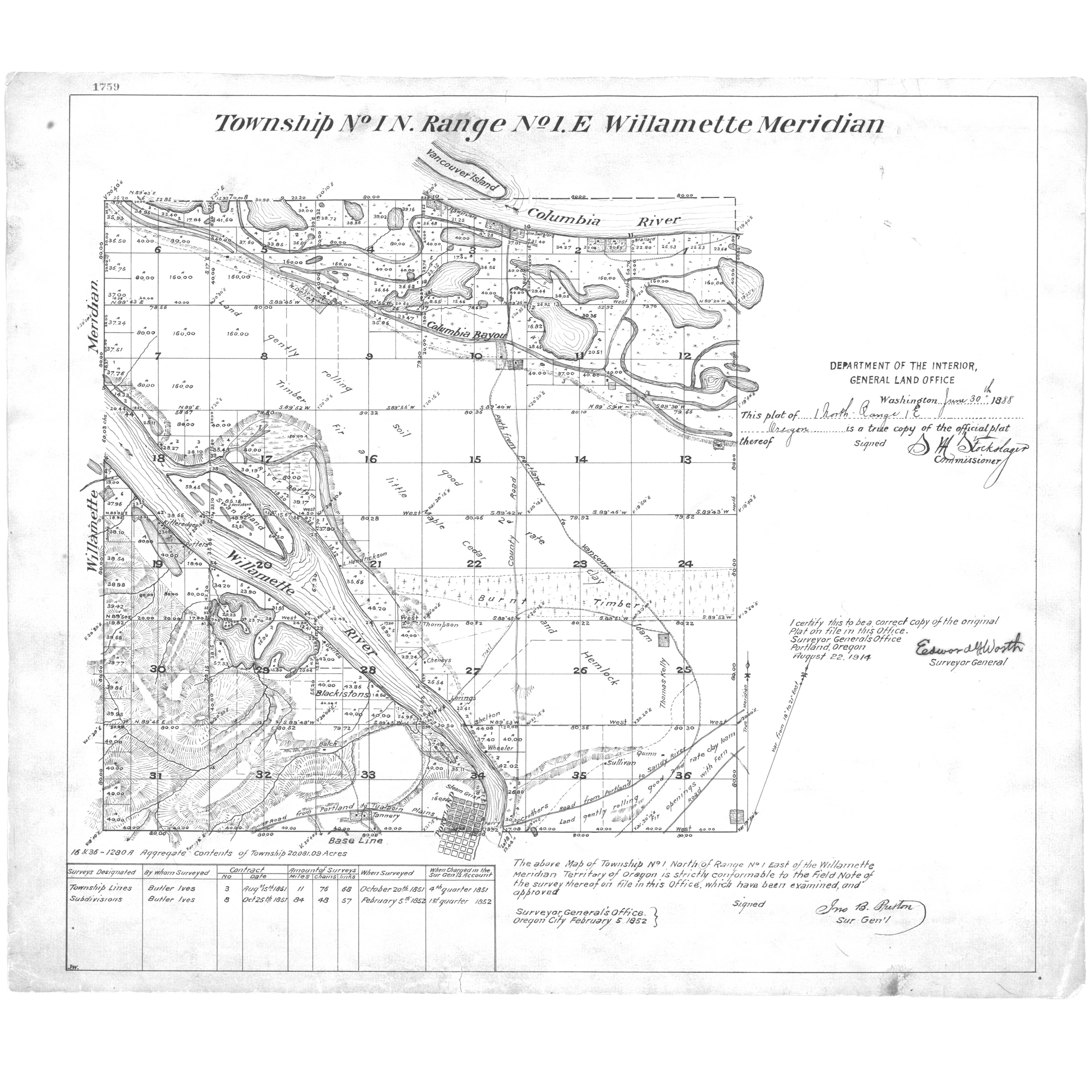
Here’s a detail from an 1852 map that conveys the complexity of the margin between river and shore in the northern edges of today’s Northeast Portland. Have a good look and we’ll discuss.

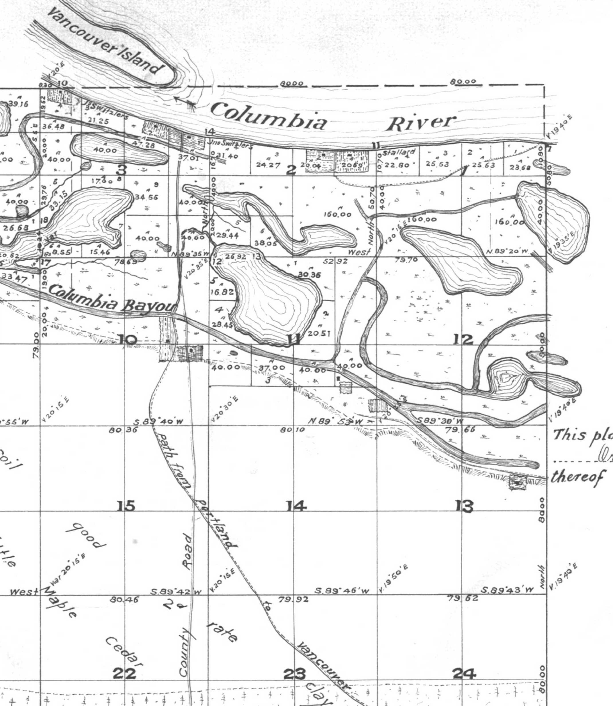
Detail of 1852 Map of Township 1 North, Range 1 East, Courtesy of Bureau of Land Management Cadastral Survey Records. The complete map plate is here in our Maps collection.

The island labeled “Vancouver Island” is today’s Hayden Island. For orientation purposes the number 24 (which is Section 24 in Township 1 North, Range 1 East) is at the intersection of NE 33rd and Prescott Street. The far right edge of this map running up and down follows the line of today’s NE 42nd Avenue.

For those of you familiar with the Willamette Meridian, NE 42nd Avenue scribes the section line between Range 1 East and Range 2 East. The number 13 is just west of today’s Fernhill Park at NE 33rd and Holman. Today’s Columbia Boulevard runs northwest-southeast just at the base of the slope (the slope is scribed on this map as a hatched line just south of the waterway).

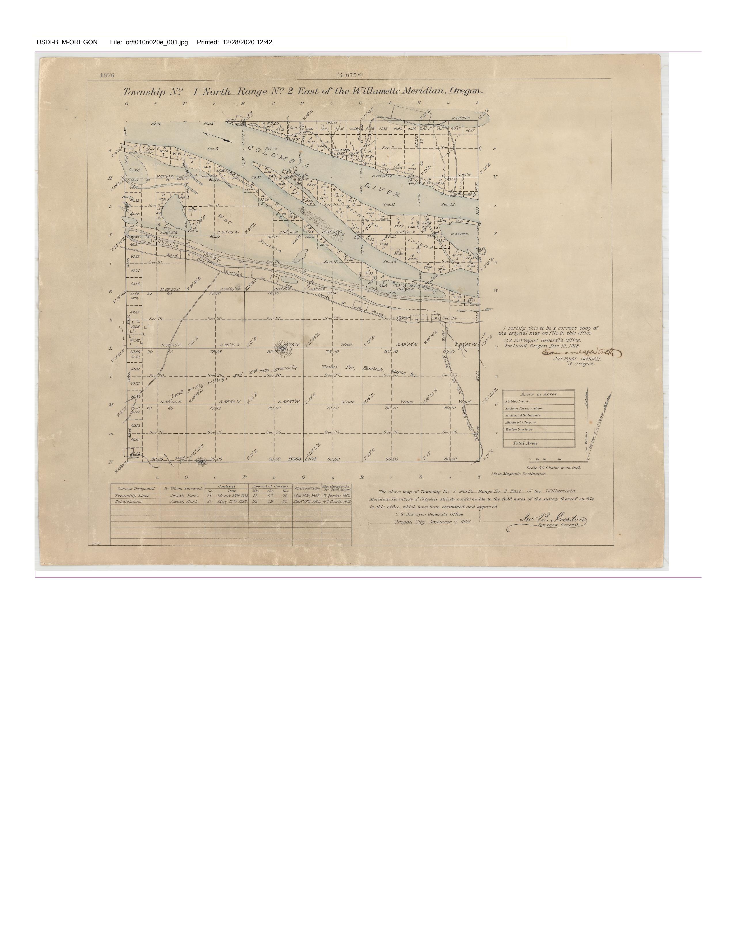
Here’s another early map that continues the look east on the Columbia shore.

This 1850s map, of Township 1 North, Range 2 East, shows the location of today’s Portland International Airport in the area between the two lakes labeled as “wet prairie,” telling us the area was typically inundated during high water. A large shoal or shallow area exists in the Columbia between shore and Government Island. The road angling up from the bottom is today’s NE Cully Avenue (the Cully family was here in 1846). The topography showing in the bottom center is Rocky Butte. This early map shows today’s Columbia Boulevard, labeled “road from Portland to the mouth of Sandy River.”

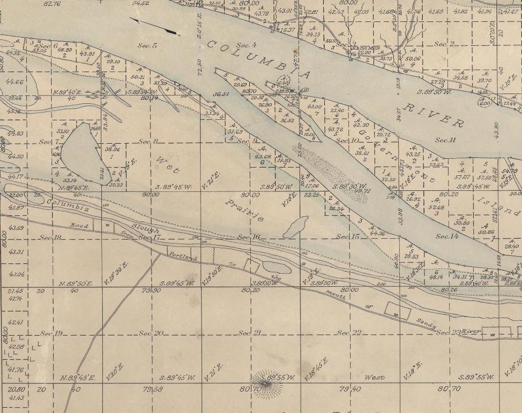
Detail of 1852 Map of Township 1 North, Range 2 East, Courtesy of Bureau of Land Management Cadastral Survey Records. The complete map plate is here.

Here’s a detail from one more map that conveys the complexity of our northern edge: an 1889 land ownership map of Multnomah County compiled by R.A. Habersham, on file at the Library of Congress. In the 40 years between these two maps, the degree of landscape change is almost hard to imagine, with a grid of streets, residents and industry beginning to utilize these northern waterways as a vast sewer system.

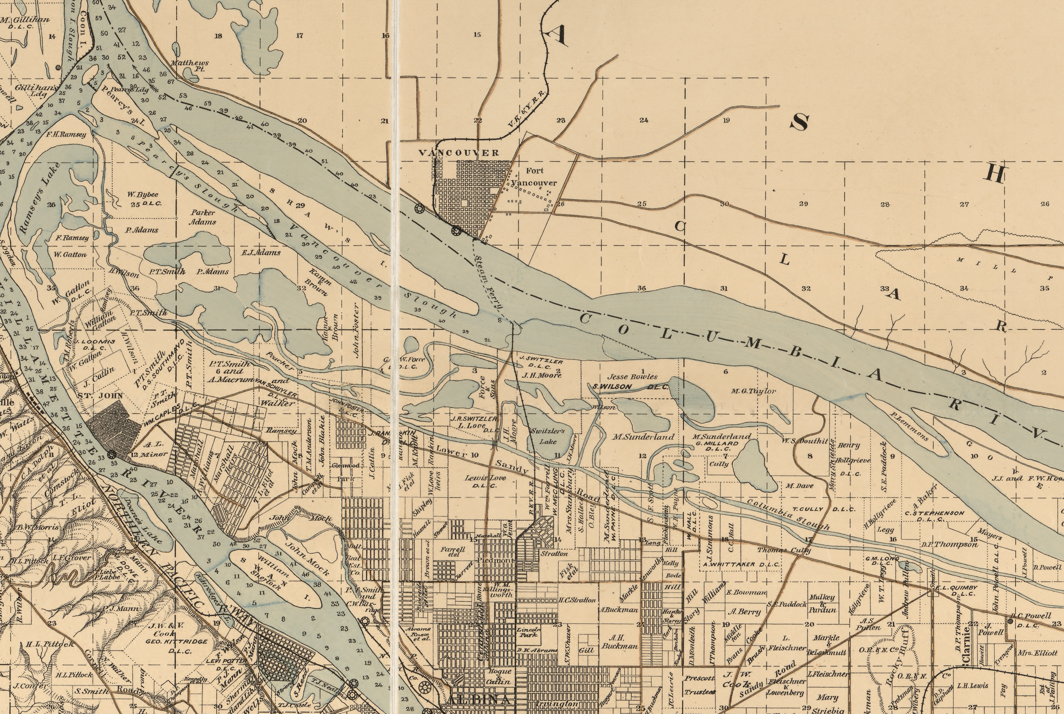
Detail of Map of Multnomah County, Oregon 1889, courtesy of Library of Congress. Here’s a link to the full map (it’s a big file).

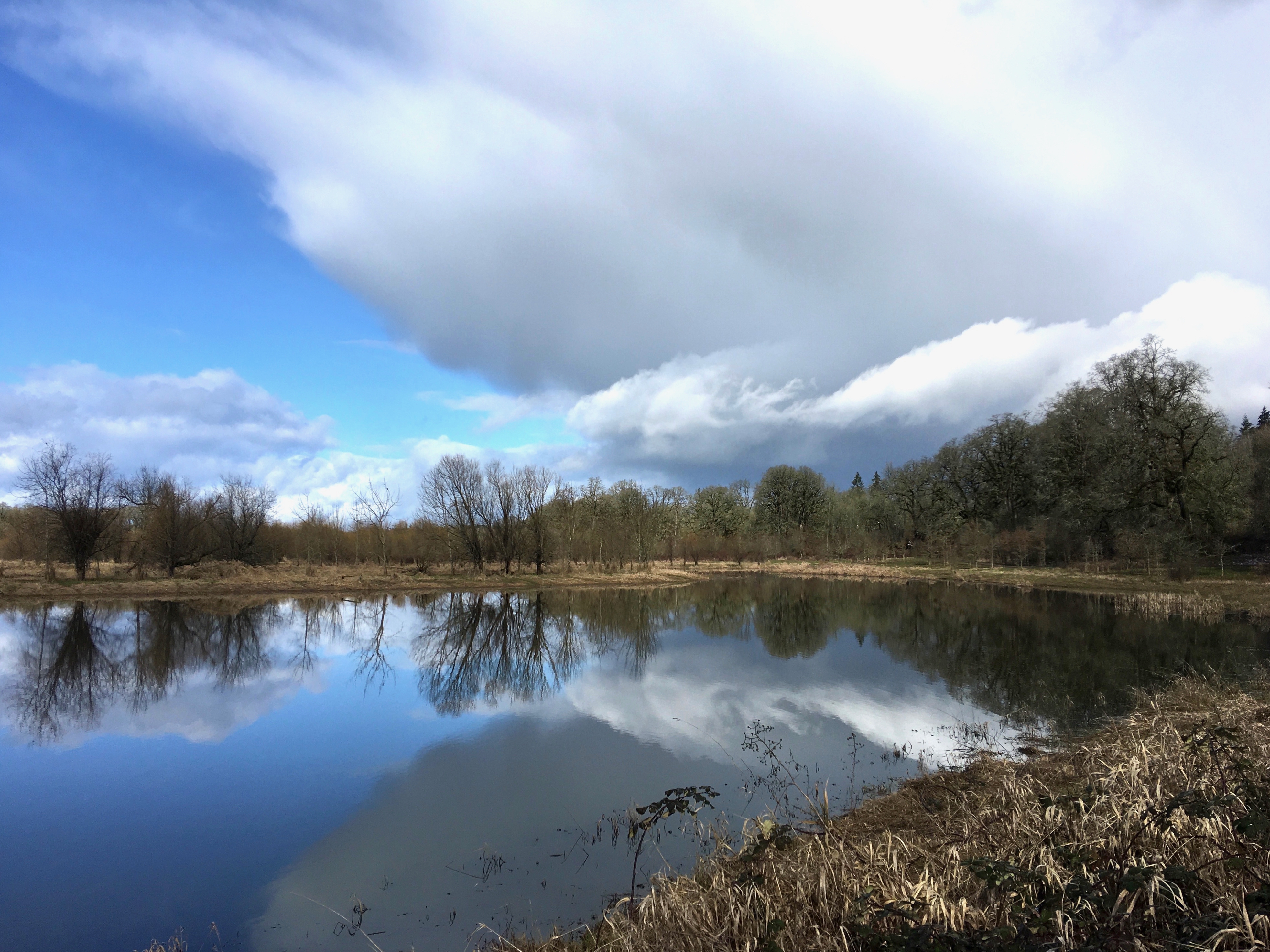
We’ve thought a lot about what this area must have looked like, and the people who lived here since time immemorial. We’ve wanted to find an approximation to suggest what all that changeable marshland might have felt like, and you don’t have to look far. Recently, we took the kayak to the Ridgefield National Wildlife Refuge just downstream from our reach of the Columbia and offer these photos to feed your imagination:

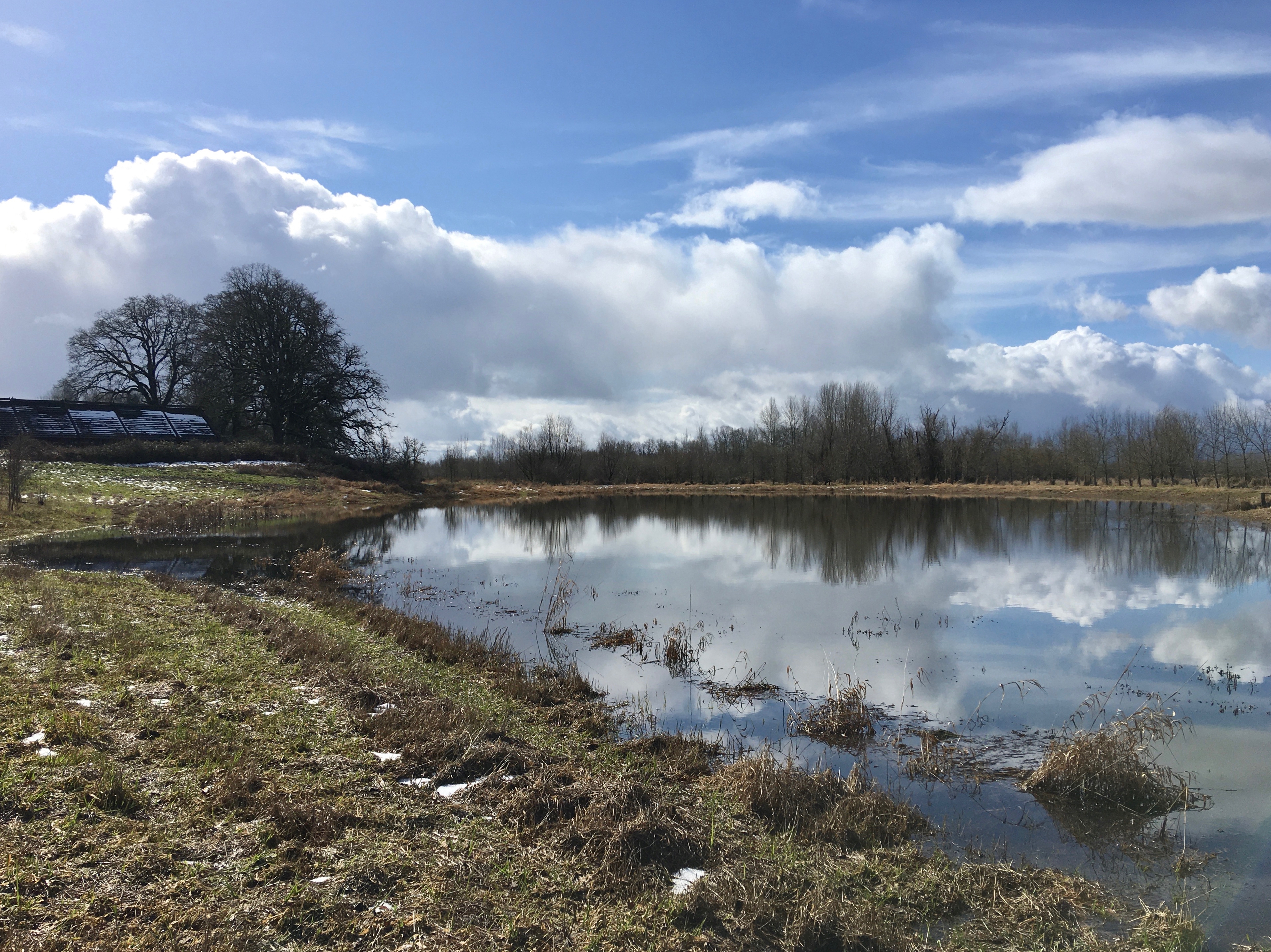
Imagining a “wet prairie.” That’s the reconstructed Cathlapotle plankhouse on the left at Ridgefield National Wildlife Refuge. February 2021

Humble virtual variety show with a sprig of history

Here’s a weeknight evening distraction that allows you to have some fun while doing some good. Our local pub / book store—Rose City Book Pub—is working hard to stay alive in the midst of the pandemic shutdown. Owner/Publican Elise Schumock has launched a weekly virtual variety hour on Thursday nights from 7:30-8:30 that’s just as quirky and interesting as the book pub itself.

Last week was the inaugural on-line show and it featured some great local music, a couple of short stories and prose read by the authors, and a little local history from yours truly. Elise asked us to provide a few minutes of local history each week, so we will.

It’s a humble, hand-made little show for sure, but kind of fun to have a few neighbors hanging around together in front of our glowing screens. If you’re at loose ends on Thursday night, have a look and you might find comedy, original music, poetry, story telling and a sprig of history.

Find the Rose City Book Pub Virtual Variety Show here, Thursday nights from 7:30-8:30.

Albina’s Williams Avenue, 1909

The loss and complete transformation of what was once a vital Albina main street will always haunt this North Portland neighborhood, in so many different ways. Important chapters of Portland history have played out here, from the early days of being its own city before becoming part of Portland, through waves of immigration, to Civil Rights protests and the vibrancy of African-American owned business, life and culture.

Today, if you don’t know this history, you might drive north on Williams past Emanuel Hospital and not know you are traveling through a kind of sacred ground.

To help us imagine this lost place, here’s a pretty amazing photo from AH photo friend Norm Gholston, and a then-and-now shot we matched up during a recent outing. Norm shared this great old pic recently: it’s the image side of a “real photo” postard, popular in this era. Click to enlarge and take a good look.

Taken from just north of the intersection with Russell Street, the 1909 photo features a look at the Kennard and Adams department store on the left, which carried a little bit of everything. The first intersection in the distance is Knott Street. That’s the Immaculate Heart Church steeple at Williams and Stanton you can see in the distance, the only common denominator that really jumps out at you from the two photos (known back in the day as St. Mary’s Church, not St. Mark’s as the Sanborn implies).

Here’s a composite of several Sanborn maps we put together to be able to visualize where Norm’s 1909 photo was taken. The red box indicates the approximate photo point. Click to enlarge.

Details from Sanborn plates 268, 273 and 274, from 1909.

If you ride, walk or drive this way—or if you didn’t know the history of this amazing stretch of street—take a moment to check out the following  multiple sources of insight about what this neighborhood meant during its heyday, and how its loss has affected the people who knew it:

Historic Black Williams Project

An article about Albina in the Oregon Encyclopedia

A nice rewind that looks back across the years by The Oregonian

Finding Ford’s Pool Hall | Adventures on Early Alberta Street

Here’s another outstanding turn-back-the-clock view of a business on NE Alberta Street: George and Sylvia Ford’s Pool Hall, Lunch Counter, Confectionery and Cigar Store, mid-block between 17th and 18th on the south side of Alberta, taken in September 1909. Click into this photo and have a good look around, there’s so much to see.

In front of Ford’s Pool Hall, 658 Alberta Street, 1909. Photo courtesy of the Gholston Collection, used with permission. Click to enlarge.

Things that jumped out at us: reflections in the windows showing the north side of the street; the faces and clothing of the men; the small advertisement in the left window advertising the “Special Masquerade” on Saturday evening, October 9th (that’s how we know this is 1909); that’s George Ford, by the way, in the middle of the group in the apron with his hand on the older gentleman’s shoulder. We guess the confection guy is on the far left in the bowtie and the cigar guy is holding the cigar. George and his friend (is he the baker from next door?) might be running the lunch counter.

Thanks to AH reader Norm Gholston for sending this photograph our way. Norm knows we enjoy being photo detective, and this one took some digging to make sure we were in the right place. Here’s the same view today:

1718 NE Alberta, formerly Ford’s Pool Hall. November 2018.


When Norm sent this one along, he knew it was on Alberta. And we could see the address over the door—658—which translates to today’s 1718 NE Alberta. Remember that all of Portland’s addresses were changed in the Great Renumbering of 1930-31.

With the current address in hand, we went out to take a look, and that’s when this got a bit puzzling because the next door neighbor building to the east—the one that houses Earl’s Barbershop—has many similar features to the building in the 1909 photo. Look at the dentals under the first and second level soffits and the short horizontal brackets that support them; the column-like pedestals along the building edges. On first glance at that block today, you’d say Earl’s is the right place, especially when you look at the modernized front of the Maggie Gibson Plaza building just to the west. Both buildings are owned today by Portland Community Reinvestment Initiatives, Inc.

South side of NE Alberta showing the entire block between NE 17th and NE 18th. Maggie Gibson Plaza building (on the right) once housed five distinct store fronts on the first floor and a large meeting space known as Baker Hall upstairs. In later years, the space was home to the Royal Esquire Club of Portland. Photo taken in November 2018. Click to enlarge.


But that notion doesn’t hold up when you dig into the details of building permits, city directories and old newspaper stories. 658 was clearly housed in the building to the west (right). Interesting to note that both were built in 1909 by the same builder for the same owner. Our hunch is they probably looked alike way back when.

The clincher is the old Sanborn Fire Insurance Map from 1924 (below), which shows all of the side-by-side stores in both buildings. You’ll find 658 on the east end of the Gibson Plaza building and there’s five feet of space to the next neighbor to the east. Remember that these maps were drawn primarily for fire insurance underwriters, so they show building proximities, location of plumbing, fire alarm systems, heating systems. S = shop; D = dwelling; FA = fire alarm box; F = Flat.

Detail from Sanborn Fire Insurance Plate 550, 1924. Click to enlarge.


The Sanborn (and city directories) show there was a lot going on in this block, on both sides of the street. Here’s a run down of the Ford’s Pool Hall neighbors, by address:

650      Vernon Drug Company

652      Peterson & Jackson Grocery, later J.H. Belshiser Grocery

654      Grite’s Barber Shop and entrance to Baker Hall, which was upstairs. Encompassing the second floor of the building was an open meeting space known as “Baker Hall,” which in the early days was where the Alberta Oddfellows Lodge met before building their own space, and in later days the first home of the Royal Esquire Club of Portland. In the 19-teens, Baker Hall was the frequent site of lectures, dances and community meetings.

656      Alberta Market, later Higbee’s Electric Radio and Hardware

Next door to the east in the building that houses Earl’s today:

660      Gabel & Son Bakery, later Alberta Bakery

662      Dr. William Luzader, Optometrist

The house on the corner to the east—addressed as 666 in the Sanborn plate—is still there today and was Freda’s Beauty Shop and home to Freda Baker.

Across the street:

651      Love’s Confectionery, Fountain and Deli

653      General Sewing Machine Repair Shop

655      Carl Nau, Taylor,  and Bell’s Reliable Hemstitching Shop

659      Alberta Realty Co.

661      Alberta Sheet Metal Co.

663      S. Salmonson Hardware and Appliance

665      Victoria Theater (with full stage and space for “MOVIES”)

The FA in front of the Victoria Theater was a fire alarm pull box.

Once we figured out the location of Ford’s Pool Hall, we wanted to know more about George and Sylvia. We found them during the pool hall days living just up the street at the corner of NE 18th and Wygant. Here’s the couple on their wedding day in Colfax Washington, October 26, 1892:

George and Sylvia Ford, October 26, 1892. Photo courtesy of Ford family.


George and Sylvie (as she was known) farmed for a while near Lapwai, Idaho in the 1890s and early 1900s before moving to Portland. They opened the pool hall, confectionary and lunch counter in 1909 and later ran a confectionary and cigar business at NE 21st and Alberta (two business lines that were frequently found together in the same retail store, candy and smokes). The Fords raised two children—George B. and John J.—and Sylvie had a busy dressmaking business as well. George died on July 23, 1937. His obit reads:

George P. Ford, Businessman, Passes Away

Geo P. Ford, who has conducted a cigar and confectionary store at Alberta and 21st Ave., for a number of years, and an old resident of this district, passed away at his home, 4925 N.E. 19th Ave., last Friday, at the age of 74 years. He leaves to mourn his death, his wife, Sylvia Ford, and two sons, George and John Ford, and several brothers and sisters. Funeral services were held Monday afternoon, Vault entombment, Riverview Abbey Mausoleum. Heartfelt sympathies goes out to the bereaved family in this, their sad bereavement.

We’re ready for the next photo mystery.

Alberta Street Photo Sleuthing | Found!

A friendly AH reader has shared an amazing photo with stories to tell, so have a good detailed look at this (click to enlarge), and then we’ll take it apart and do some sleuthing. There are so many things to think about here.

NE 26th and Alberta looking north/northeast, 1909. Photo courtesy of the Gholston Collection, used with permission.

In past entries, we’ve delved into mom and pop groceries, delivery horses and carriages, and the bustling early Alberta Street. Each is present in this picture taken at the corner of NE 26th and Alberta in 1909, three years before the Broadway Bridge was built and at a time when Portland had only 3,540 registered automobiles (so everyone was on foot, horseback or streetcar).

Just so we’re clear, Lester Park (the location painted on the side of the wagon) wasn’t a park, it was the name of a plat or subdivision, contained in today’s Concordia neighborhood (just one of multiple plats that make up today’s neighborhood). Here’s a look at that plat, filed in 1906 by H.L Chapin of the Arleta Land Company. It’s a compact little rectangle, running from Alberta on the north to Prescott on the south and between NE 25th and NE 27th, 145 total lots.

Lester Park Addition Plat, 1906. North is to the left, east is up.

The Lester Park Grocery was a dry goods and butcher store that stood in what is today an empty lot just west of the Waffle Window, 2624 NE Alberta. Its original address was 834 Alberta to be exact (remember that all of Portland was renumbered in the 1930s, so this address was before the change). The shop that H.L. Reynolds, his wife Carrie and her daughter called home also included several rooms for the family to live.

We’ve walked all over this part of Alberta with this picture in our hand, consulted early Sanborn maps of the neighborhood, examined building permits and local buildings to make an informed statement about exactly where this is. Here’s what we see and why we believe this view is looking north/northeast from out in front of Reynolds’s shop at NE 26th and Alberta:

  • There are some distinctive houses in the background of this old photo, including a church steeple, which we believe is the building on the southeast corner of NE 27th and Sumner known today as St. Luke Memorial Community Church of God (2700 NE Sumner), but was then the newly constructed United Brethren in Christ Church, built in 1910.
  • Appearing directly in front of the carriage driver in the old photo is a light colored home. This small hipped-roof house with chimney slightly off center and front dormer is today’s 5028 NE 26th (painted red) with the front porch now enclosed. This house was built in 1906. Here’s a look from Google streetview. See it under all that?

Current photo of the small house that appears just above the horse’s rump in the 1909 photograph. Look carefully at the hipped roof, mini dormer on top and slightly off-center chimney. Yep, that’s the same house. Built in 1906 by Mary L. Coger. Thanks to Google Streetview.

  • We know that in 1909 the Alberta Streetcar line (visible in the foreground of the photo) was still just two rails in the dirt; and we know this part of Alberta was not paved until the summer of 1911).
  • We also know that H.L. Reynolds, who may well be the man in the photo, was associated with the grocery until about 1910. The 1910 census shows him (age 36) and his wife Carrie living in the residence associated with the shop.

That would make the corner of the house you can see just above the horse’s head about where the corner of Mae Ploy Thai Cuisine is today (obviously a different building).

Reynolds was arrested in April 1909 for assaulting his wife and stepdaughter and disappears from the Portland scene the next year. Meanwhile Carrie takes over the shop (and probably the horse and carriage) and decides to sell it all off. Check out this series of classified ads from The Oregonian where she almost pleads for a buyer:

March 31, 1911


April 8, 1911


April 21, 1911

Carrie did eventually sell the place and leave town. The shop was taken over in 1913 by Mrs. Edna Albertson who ran it as Albertson’s Dry Goods Store (not related to today’s Albertson chain) until 1921 when she was killed in an automobile accident while traveling to Tillamook. How this photo has come down the years–who saved it and why–remains a mystery.

This picture is definitely worth 1,000 words. Thanks to Norm Gholston for the opportunity to take a trip back through time. Here’s another photo sleuthing adventure just up the street related to Ford’s Pool Hall. And one more related to a family bakery with a fascinating back story.

We love this photo and are always on the lookout for views like this that help us think about the past.

Hello There Oregonian Readers!

That was a very nice piece in The O today about accessing the past online. I’m honored to be included with some very capable and cool history sites. I invite you to have a good look around…there’s lots here about the Alameda neighborhood and the fruits of old house research in general. I’m always on the lookout for stories and information about the evolution of this neighborhood, and particularly looking for old photos of homes, the school, etc.

Last week a former resident sent me some family pictures taken in the 1950s out in front of her house on NE Regents, which I considered a major find. There just aren’t many photos of our old houses in existing public collections. So, send me a copy, a story, a lead. And bookmark www.alamedahistory.org because there’s always something new — er…old — here to see.

-Doug

Living Where They Grew Up

home-ad-17-december-1911.jpg

Advertisement from The Oregonian, 17 December 1911.

Because we are such a mobile population, it seems unusual when people stay rooted for a lifetime in their communities, and particulary so when they live as adults in the homes where they grew up. I’m doing a series of stories profiling Alamedans who live in the houses where they grew up. Here are people who have spent most of their lives under one roof.

By visiting with these Alamedans, we hope to witness how the neighborhood has changed–and how it has stayed the same–and how the unique context of a house influences our lives.

Enjoy. And let me know if there are some other folks I should talk to…

Click here to have a look at the series, which from now on will reside under “Alameda Stories.”

%d bloggers like this: