This week we’ve been reflecting on some of the interesting stories from the early history of the Vernon neighborhood, first platted in 1903. AH reader Stephen Peifer asked about the Alberta Street flood of the 1920s, and sure enough echoes of that event can be found in both The Oregonian (our morning paper) and the Oregon Journal (our afternoon paper). Sigh, can you imagine having two major daily newspapers?
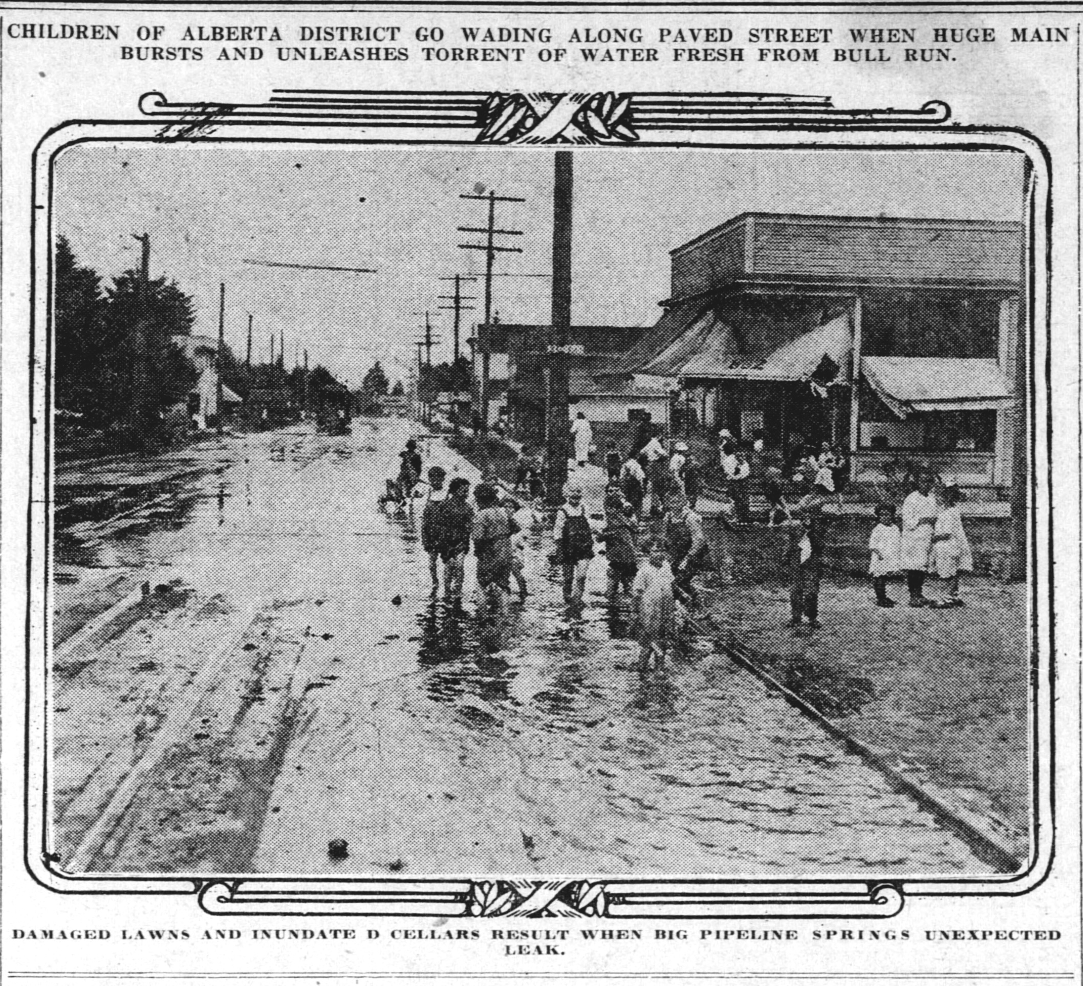
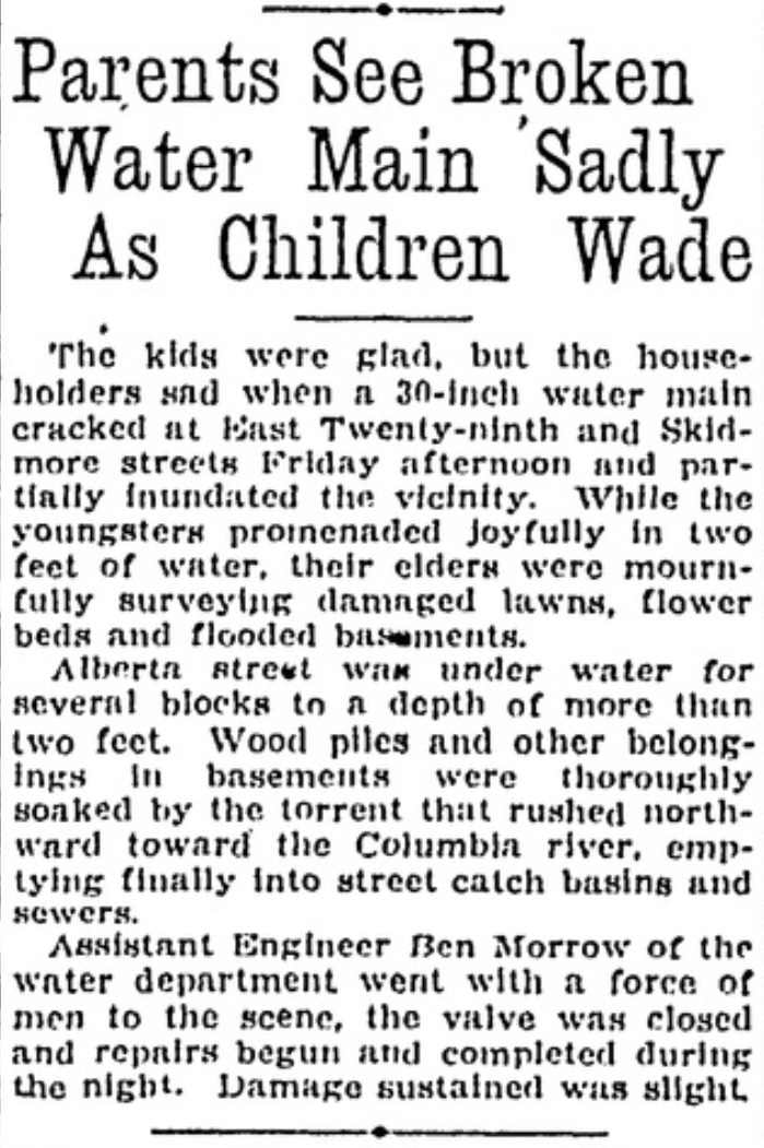
Here’s a photograph from The Oregonian, looking east on Alberta at NE 28th, taken on July 24, 1920. A story about the flood, from the Oregon Journal, follows.
This flood story bears a striking resemblance to a similar water main break on March 16, 2019, which we wrote about here on the blog, when a cracked pipe produced a gravel bar near NE 24th and Skidmore (the 30-inch water main runs east west under Skidmore, careful where you step).
It’s not too late to sign up for one of the programs we’re doing for the Architectural Heritage Center this summer, kicking off this Saturday morning with a program at AHC focused on Portlanders’ historic connection with the Willamette River.
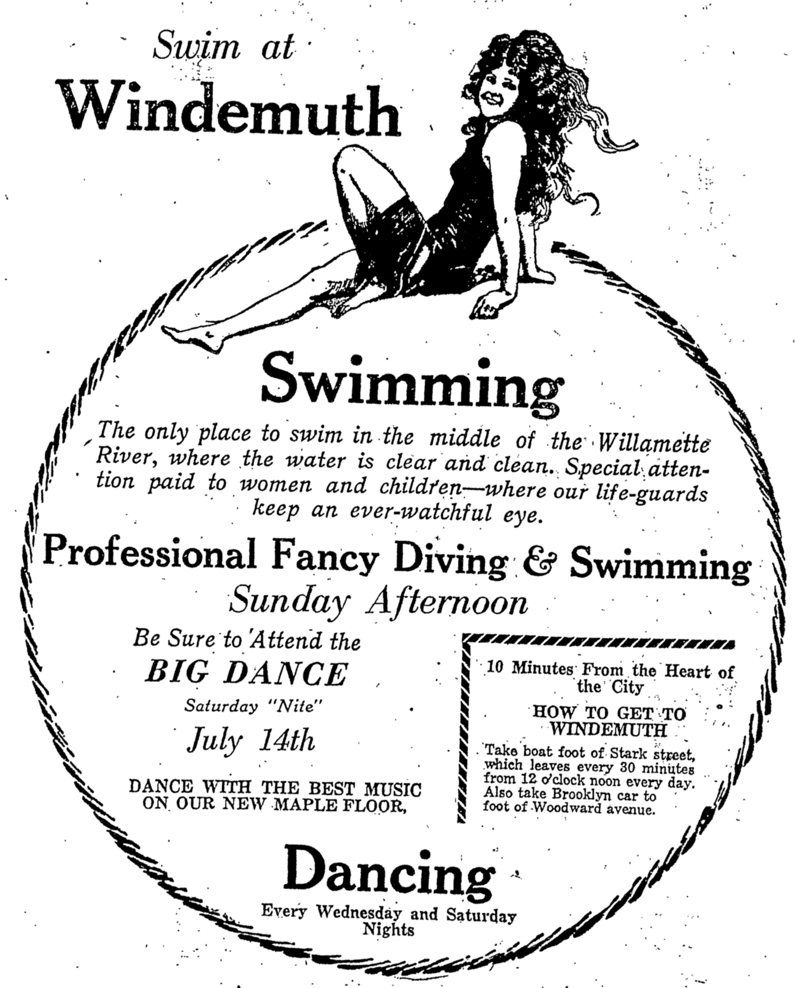
Saturday, May 10th from 10:00-11:30 we’ll explore the colorful history of Portland’s southeast waterfront in the vicinity of Ross Island, where Portlanders flocked to two hugely popular swimming and waterplay venues: Bundy’s Baths and Windemuth. We’ve written about these here on the blog and will be delivering a program with photos, maps and stories that help bring these former Portland water recreation mainstays back to life. Program based at AHC, 701 SE Grand, Portland.
Vernon Walk – Thursday, June 5th from 6:00-8:00 p.m. we’ll be leading a history walk that explores the Vernon neighborhood, from development of Alberta Park, to the fall and rise of neighborhood schools, to patterns of redlining from the 1930s-1950s, the presence of a dairy, a much-loved synagogue and a street full of small businesses.
Alameda Walk – Wednesday, June 11th from 10:00-Noon This walk through the Alameda neighborhood will include insights about pre-development conditions, planning and construction of the neighborhood, the Broadway Streetcar, home construction and architectural styles and points of local interest including the story behind Deadman’s Hill and the 1920s uproar over the former Alameda Park Community Church.
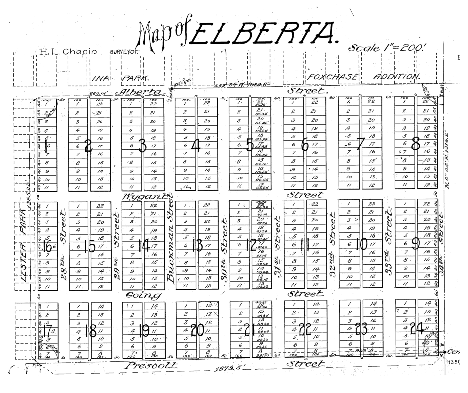
We’ve been looking into the Elberta Addition this week, a 24-block subdivision platted in August 1906 bounded by Northeast 33rd and 28th on the east and west, and by Northeast Alberta and Prescott on the north and south.
It’s a name that has caused some confusion in the past given its proximity to Alberta Street. Readers will recall that name stems from the fourth daughter of Queen Victoria, Princess Louise Caroline Alberta, an honorific street name bestowed in the 1880s. Not to be confused with Elberta.
Elberta was once the most popular variety of peach, named for the wife of the Georgia peach grower who established the hybrid in the 1800s. It’s rich, tart flavor eventually fell out of favor to sweeter varieties, and what had been tens of thousands of acres of peach orchards all across the country were uprooted. Our peach sources tell us that finding an Elberta peach today can be challenging.
This 50-acre subdivision, part of today’s Concordia neighborhood, was once forests, orchards and fields, part of the Buckman Estate and may well have known its own share of Elberta peaches. But when real estate speculation boomed in Portland after the 1905 Lewis and Clark Exposition, properties like this became valuable for conversion to residential use.
Angeline B. Richardson, sister of Isaac Buckman, owned the property (and many other properties on Portland’s eastside) and when she saw the writing on the wall for the rapidly increasing development value, she platted the fields into 479 lots, each 40 x 100, and began selling them off, with the help of her friends Thomas Benton Potter and H.L. Chapin.
From the Oregon Journal, August 5, 1906
Potter and Chapin were the principals of a much larger real estate syndicate that developed rural properties in Kansas City, San Francisco and even on the Oregon Coast: Potter was the driving force behind the ill-fated Bayocean community west of Tillamook that was eventually washed away by the Pacific Ocean. They also initially sold most of the lots in the adjacent Ina Park, Lester Park and Vernon subdivisions here in Northeast Portland.
About 1906, the Potter & Chapin firm changed its name to the Arleta Land Company (which just to keep things interesting, The Oregonian sometimes confused with the Alameda Land Company), named for Thomas Potter’s youngest daughter Arleta. The firm continued to develop and sell properties across Portland’s eastside, including in the Mt. Scott – Arleta neighborhood which it platted in 1903. The Arleta Land Company kept a fairly low profile, unlike other developers who paid for robust advertising campaigns in local newspapers. Arleta Land Company’s presence was almost entirely focused on classified advertising where business was brisk in 1906-1908 with news of properties being bought and resold, and homes built.
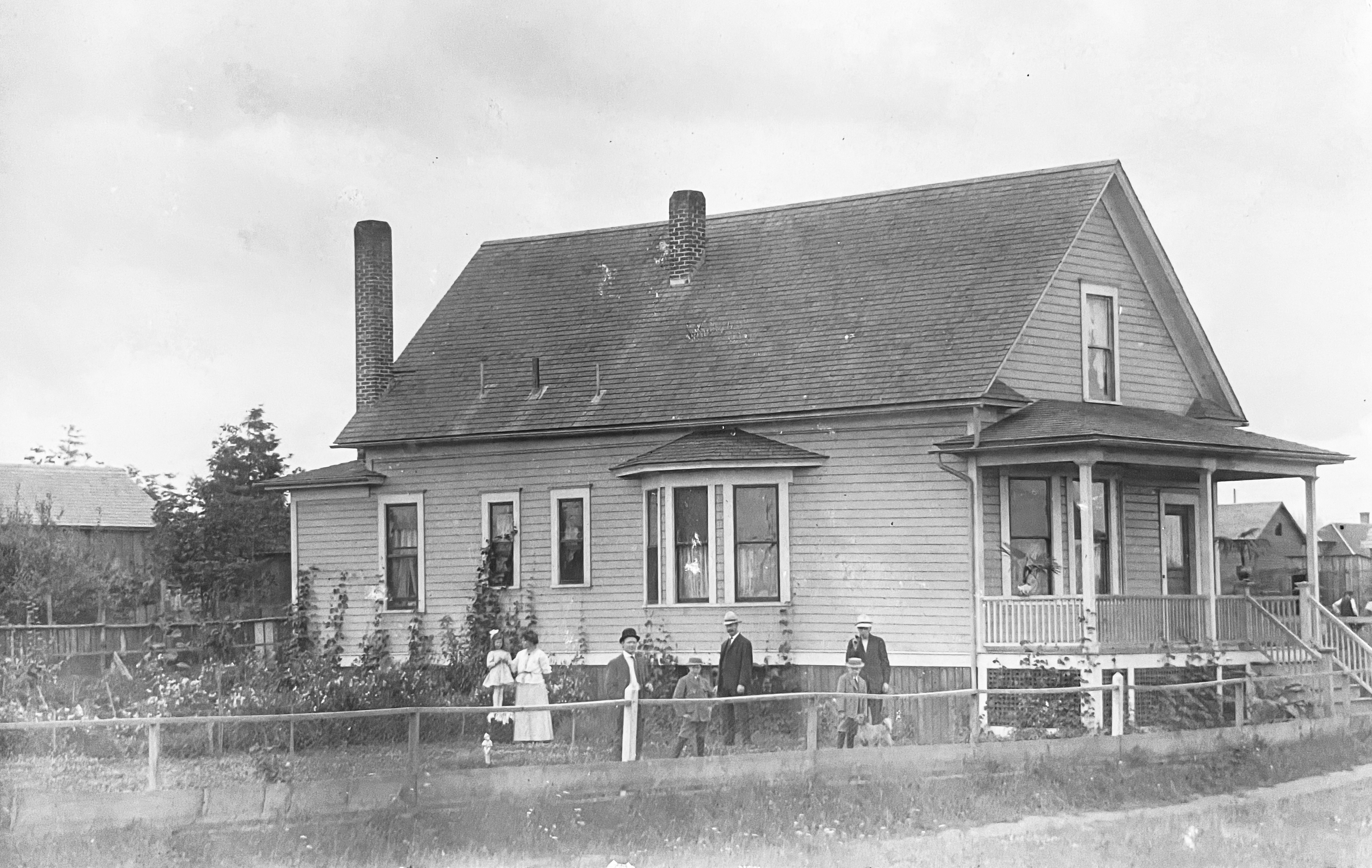
In other research, we’ve come across an interesting photo of the young Elberta Addition, showing the former home of the Hans C.S. and Minnie von Homeyer family, located at the southwest corner of NE 27th and Going. Click into this photo for a good look, it’s a beauty.
Southwest corner of NE 27th and Going, known as 850 Going Street prior to the Great Renumbering.Courtesy von Homeyer Collection
Today a 1910 Victorian-style home known as the “Going Queen” is on that property. But back in 1907, the von Homeyers bought the two lots from the Arleta Land Company for $350 and built this house. Unfortunately for them, fire destroyed their home on July 28, 1907. This rich photo has many stories to tell, and reminds us of the rural nature of the area.
Today, Elberta is a great place for a walk to appreciate residential design and construction from the first decade of the 20th Century. We’ve enjoyed exploring Elberta in this post about its alleys, which are like a built-in trail system for many of us dog-walkers. And in this bit of photo sleuthing.
Four congregations have shaped this 106-year-old neighborhood church. Today, it’s a place for community gathering and events.
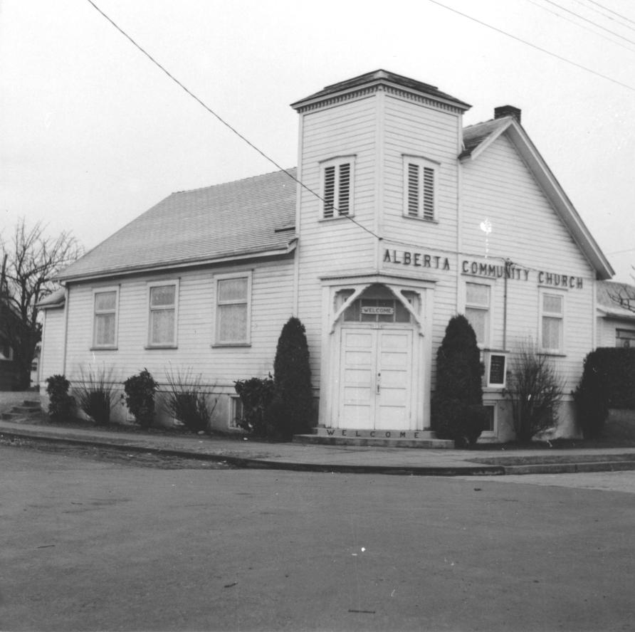
Maybe you’ve noticed the busyness and fresh coat of paint on the former church building at the southeast corner of NE 23rd and Sumner. If you haven’t walked by in a while, go take a look to admire the copper gutters, leaded windows and the crisp simplicity of this building form that has been adapted by four separate congregations in its 106 years.
Alberta Community Church, 1958.Photo courtesy of the Mennonite Archives of Ontario, University of Waterloo.
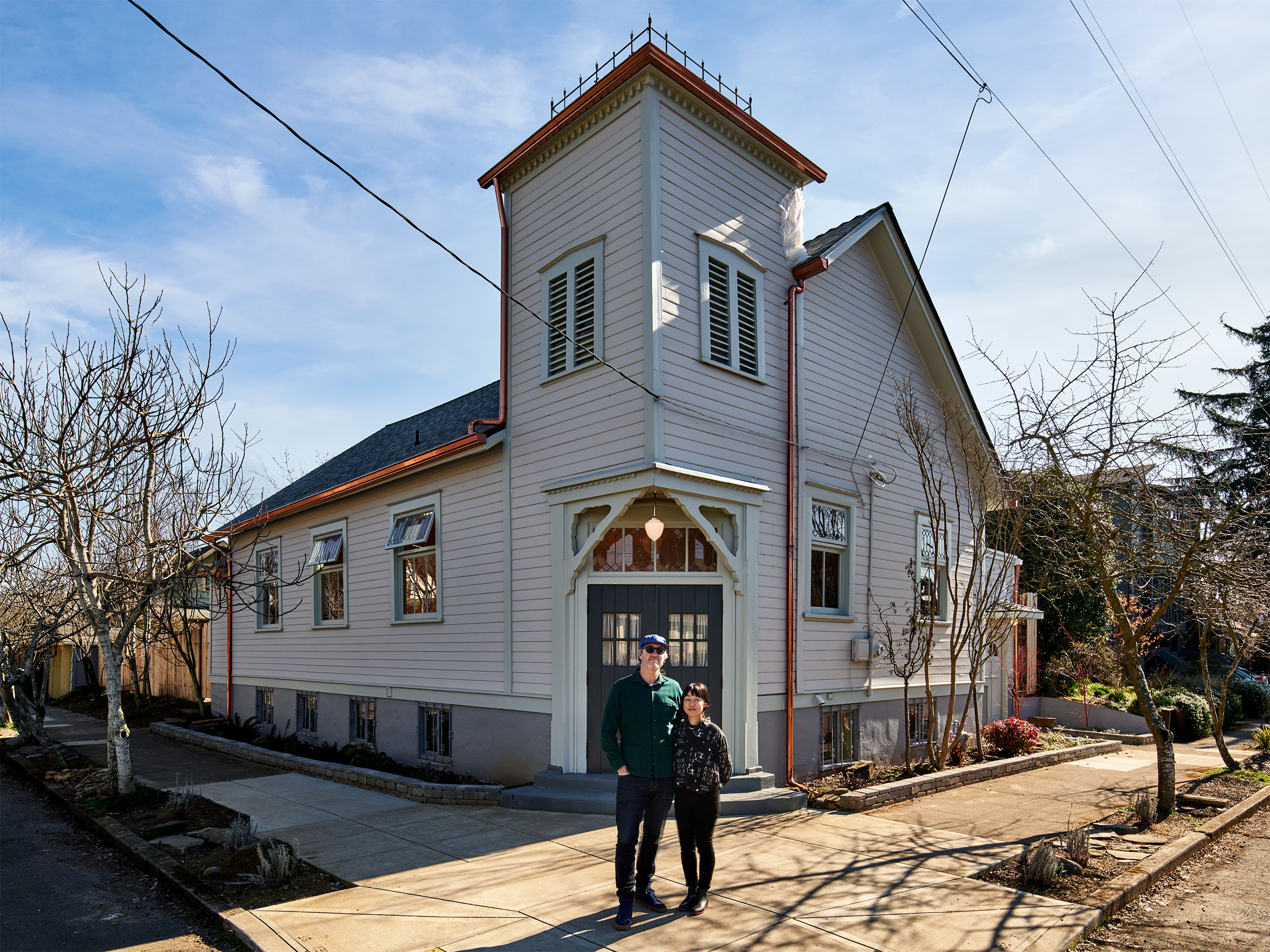
Known since 2004 as The Little Church or TLC, a one-floor event space operated by private owners and a rental apartment downstairs, the building sold in 2021 and has been a pandemic-era passion project for new owners Matt and Yuka Hollingsworth who have carefully restored, repurposed and renamed this stately time traveler.
Today this wood-framed building is known as Mildred Hall, taking its name from the east-west street upon which it is situated. Sumner was originally called Mildred Avenue in the 1903 Vernon Addition Plat, but renamed during the 1920s. Downstairs at Mildred Hall is Sumner Studio, an art studio for classes, workshops and shared studio space.
Matt and Yuka Hollingsworth in front of Mildred Hall, NE 23rd and Sumner.Photo by Shane McKenzie / Portland Imagery.
Today’s Mildred Hall started out as the Norwegian Danish Congregational Church, built on its vacant lot in 1916 by Norwegian immigrants as a spiritual center for members of the Scandinavian immigrant community living on Portland’s eastside, and distinct from the other Scandinavian faiths present in town. Church services and Sunday school classes were entirely in Norwegian, signage was in Norwegian and even construction was Norwegian in accordance with design standards set in the old country. Entrance to the original building was once in the center of the west wall.
The Mennonite Church began renting the building from the Norwegians in 1929 then bought it outright in 1938 making it the only Mennonite church on Portland’s eastside, which became known as the Alberta Community Church. Big changes were made then including moving the primary entry to the northwest corner, adding the faux bell tower and excavating a basement for kitchen and study rooms. The Mennonites added more space in 1958 and then outgrew the building altogether in 1965, selling to the Portland Korean Church.
From 1965-1977, the building was the center of Korean cultural life in Portland. In addition to its regular attendees who came from across the Metro area, the church welcomed families with adopted Korean children who wanted their kids to have a connection with Korean identity, offering classes in language, history, art and dance. The church was also well known across Portland’s port facilities as a place for Southeast Asian merchant marine sailors to come for religious services, support and fellowship. By 1977, the popular church outgrew its space and moved into a building downtown.
In 1980, the building became the Fellowship Church of God, which in 1986 also acquired the former Alberta Masonic Lodge across the street to the west as the flagship building for its growing Black congregation. With the shift of use to the larger building across the street, Fellowship leaders repurposed the older and smaller church building as an extra kitchen, basketball court, classroom and storage. By 2004, the Fellowship Church of God outgrew both spaces and later relocated to NE 122nd.
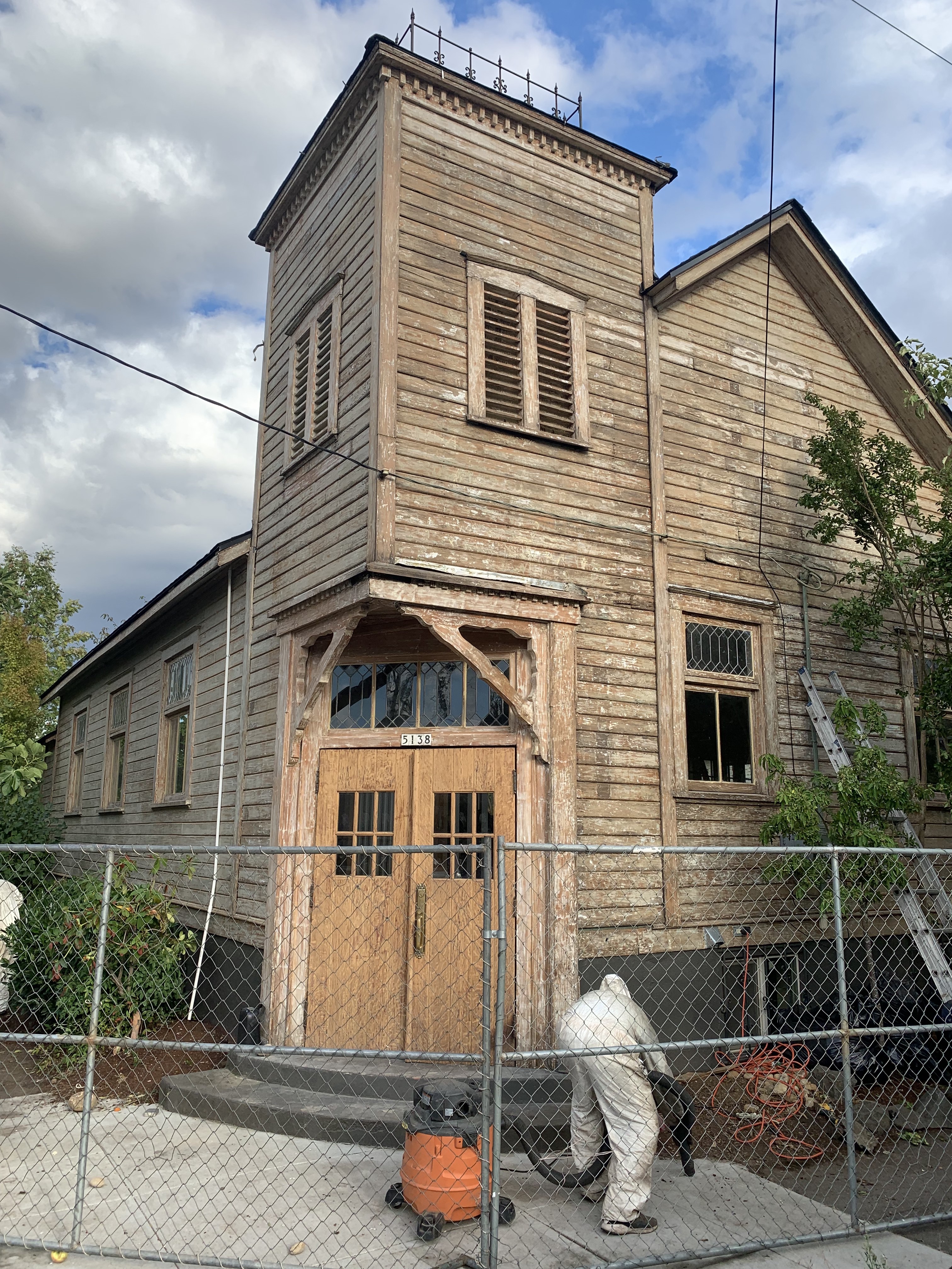
For the Hollingsworths, Mildred Hall has been a labor of love. They’ve served as general contractors and been involved in every construction decision along the way, and there have been quite a few including insulation, windows, HVAC, ceilings and generally trying to harmonize design elements across the multiple eras of change visible in the building.
Clean up after paint removal.Photo courtesy of Matt Hollingsworth
Most importantly, they wanted the building to continue bringing people together, just as it has throughout its life.
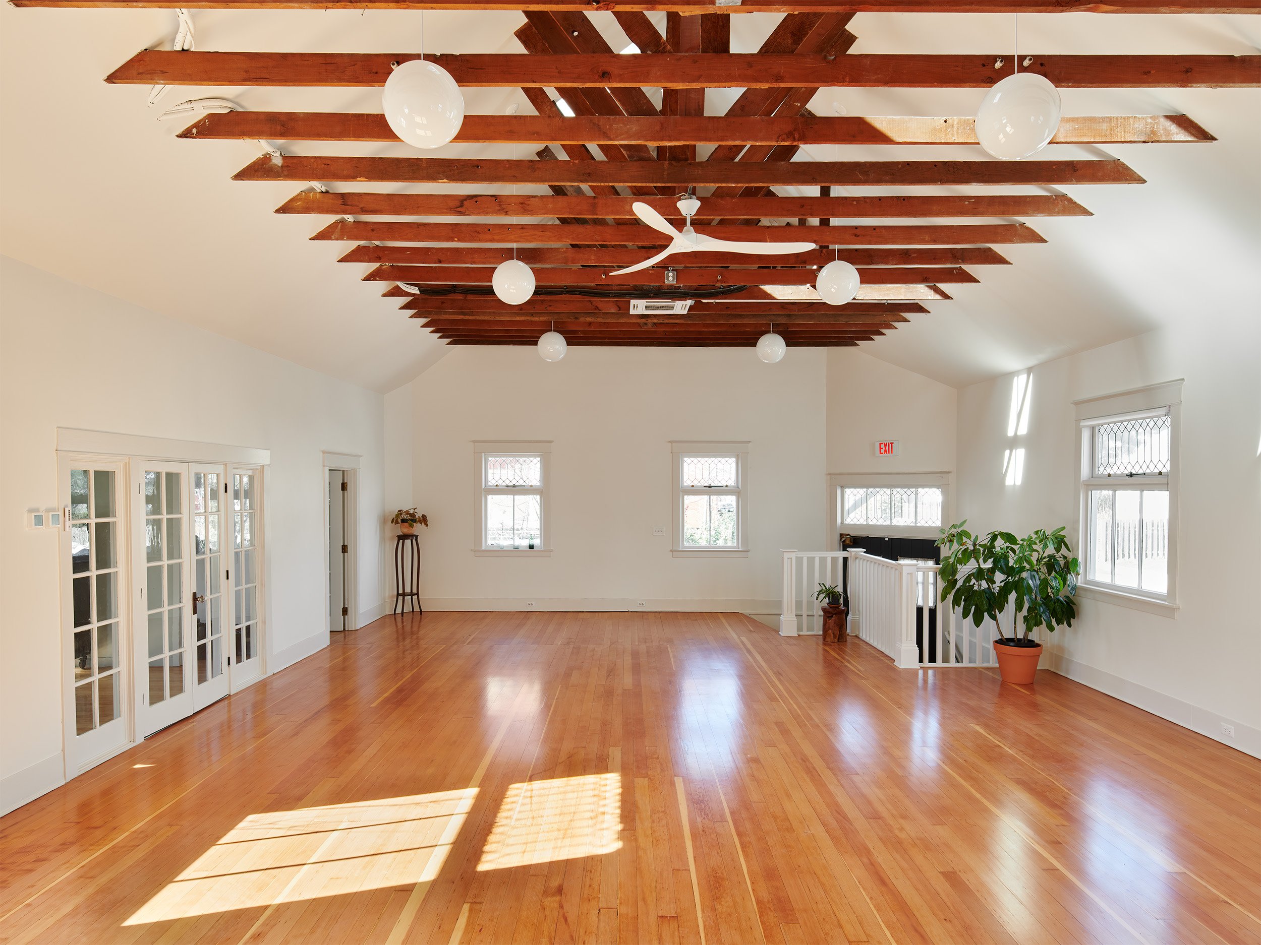
Mildred Hall Interior. Photo by Shane McKenzie / Portland Imagery.
“In a city that is tearing down old buildings to make money off of new builds, we have ensured that this building will be a part of the neighborhood for many more years,” writes Matt.
The couple has opened Mildred Hall and Sumner Studio for free community events such as movie nights, flea markets and parties for local residents to get to know their new / old neighbor. It’s available for rent for private gatherings as well. Time to go take a look.
Here’s a summer weekend morning neighborhood history walk idea for you.
Our friends at the Vernon Neighborhood Association have sponsored a series of walks in Vernon and in Woodlawn this summer that are free, fun and (we think) interesting.
I’m leading the Vernon walk this summer and there are two more scheduled: Sunday, July 31st from 10:00-noon, and Sunday, August 28th from 10:00-noon. During our two hours, we’ll turn the clock way back to explore the multiple layers of history in Vernon, the dynamics of change that have shaped the neighborhood and all of east Portland, and visit several time traveler locations during a one-mile walk. Registration through VNA is required for meet-up specifics. Both walks are capped at 20 people and have started to fill up. Learn more on this VNA registration page.
“Old Vernon” is just one of the stops on our the Vernon Neighborhood Walking tour. This building was the center of neighborhood life from 1907-1932, do you know where it was? You might be surprised. Join one of the two Vernon walking tours to hear its story and memories from those who knew and loved it.
The Woodlawn walk is ably led by neighborhood historian Anjala Ehelebe, who will describe the character, stories and evolution of Woodlawn. Anji’s walks are Saturday, August 6th from 11:00-1:00 and Saturday, August 27th from 11:00-1:00.
Come join us as we connect past and present right here close to home.
We’ve been asked recently about the naming of Alberta Street in north and northeast Portland. The short answer is that it has to do with the British Royal family by way of Canada.
But it’s also a reminder about the development of early Portland.
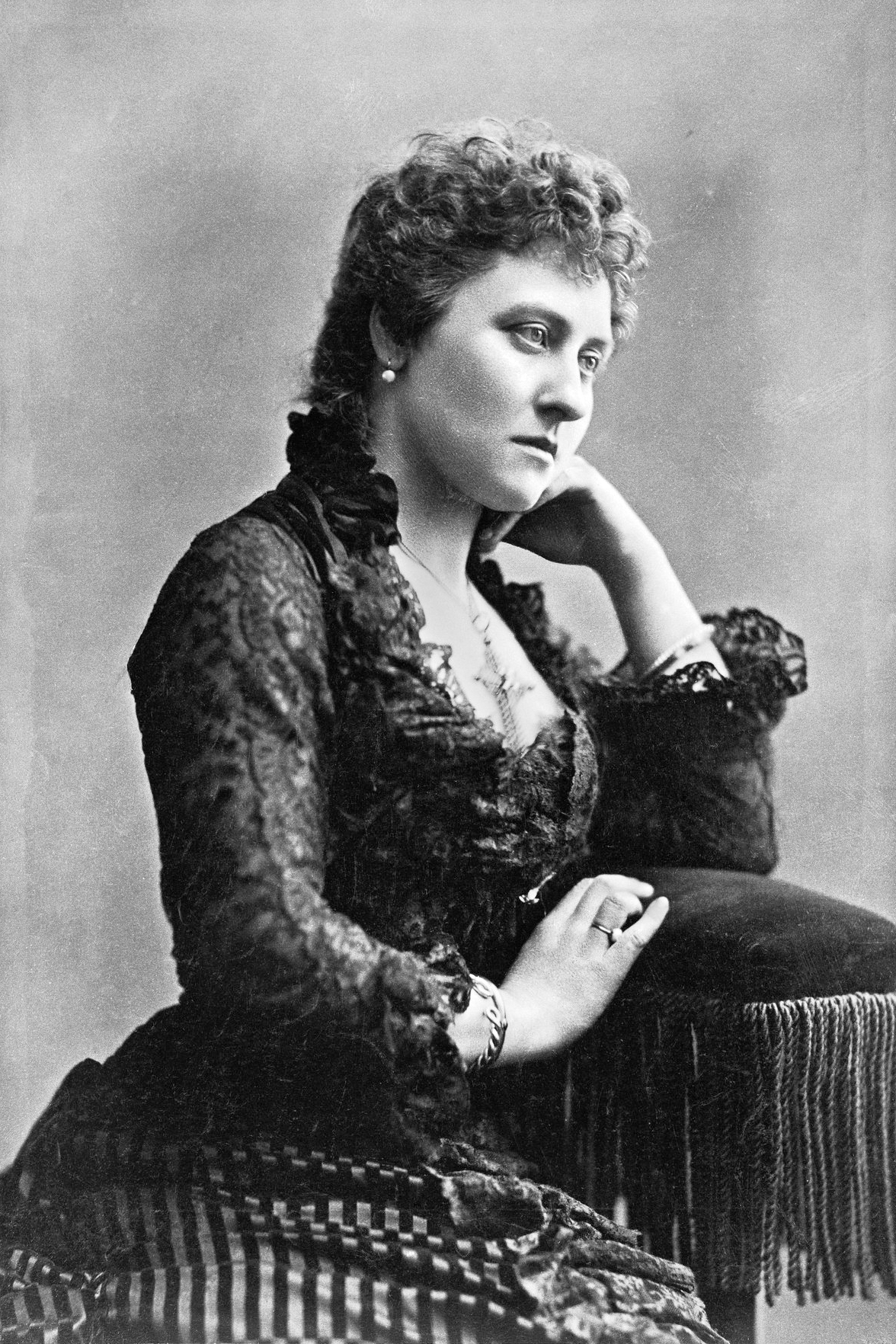
Alberta was named for Princess Louise Caroline Alberta, the fourth daughter of Victoria, Queen of England. Her husband was John Campbell, Marquess of Lorne and Governor General of Canada from 1873-1883. In September 1882, the couple made a swing up the west coast, traveling by ship from San Francisco to her mother’s namesake: Victoria, British Columbia, Canada. Having royals out this way was a very big deal in Canadian and American newspapers of the time.
Princess Louise Caroline Alberta about the time of her visit to the West Coast.Image source:The Royal Collection Trust, object 2903653.
Here’s where the Portland connection comes in.
About that time, our area was booming: the city we think of as Portland today was actually three separate cities, Portland, East Portland and Albina. There were similarities and some connecting common threads, but each had its own street system, addressing system, governance.
Albina, which historian Steve Schreiber reminds us was actually pronounced “al-bean-uh,” was just being platted. For more on Albina, check out Steve’s outstanding history (and his whole website on the legacy of Volga Germans in this area).
One of the developers planning Albina was Portlander Edwin Russell, who had immigrated here from England and was manager of the Bank of British Columbia in Portland. Russell had his own connection to royalty, having descended from the Duke of Bedford.
As Russell planned streets in the new suburb called Albina (and on a plat called Albina Heights), he named one street after himself: Russell; one street after his business partner: Williams; and one street after Princess Louise Caroline Alberta, whose visit to the region was causing a stir, particularly among Queen Victoria’s emigrated loyal subjects. The Princesses’s multiple names were being applied to geographic features all across the western map, including Lake Louise and the Canadian province of Alberta.
Later, as Portland expanded east of today’s Martin Luther King Jr. Boulevard, the street named Alberta expanded east too.
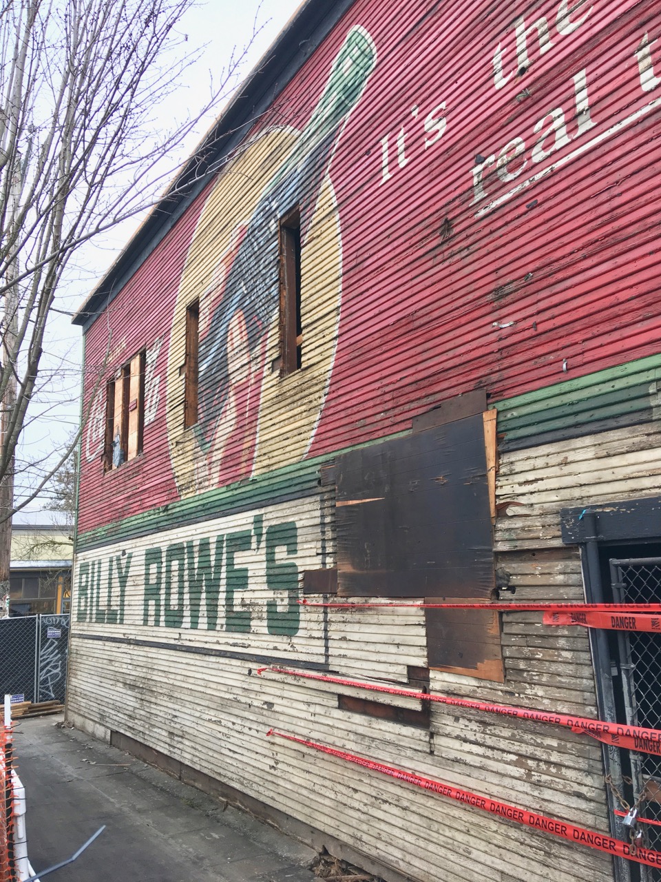
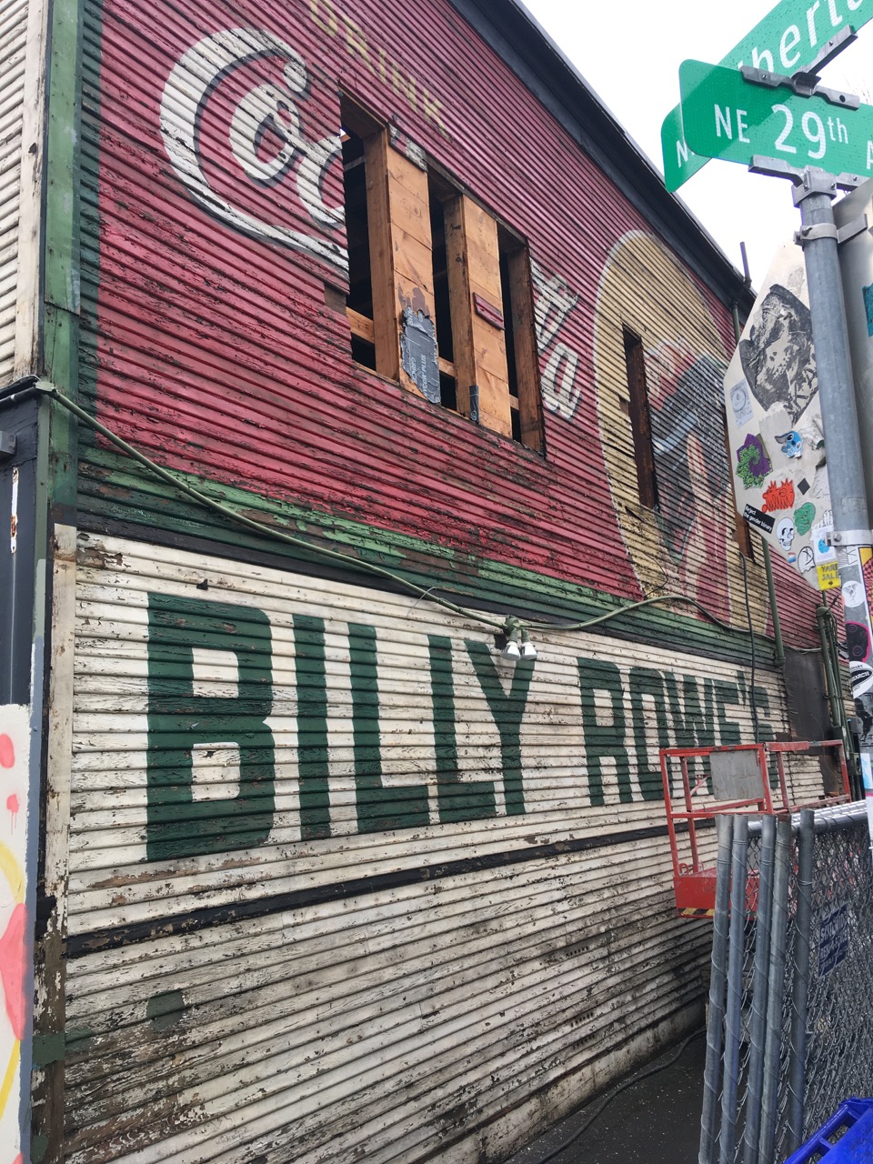
We’ve heard from the property owner working on restoration of the former Billy Rowe’s Tavern building (recently known as Bernie’s Southern Bistro) at the southeast corner of NE 29th and Alberta.
Unfortunately, the mural on the west wall must go.
We’ve been watching this week as an amazing wall-size advertisement from the 1940s has resurfaced during restoration, and as we’ve learned more about Billy Rowe.
O’Cardinal Properties—the current building owner—was as amazed with the find as the neighborhood was, and intrigued with the possibility of incorporating the original material of the painted wall into the renovated space. But testing for lead late last week returned results that have ruled that out.
“We love the signs and would like to preserve it,” wrote O’Cardinal’s Property Manager Monica Geller in a weekend e-mail exchange.
“However, last week we got the paint tested for lead and it came back with extreme lead paint ratings that will not allow us to retain the mural as is, even with a strong clear coat intended to contain the lead paint.”
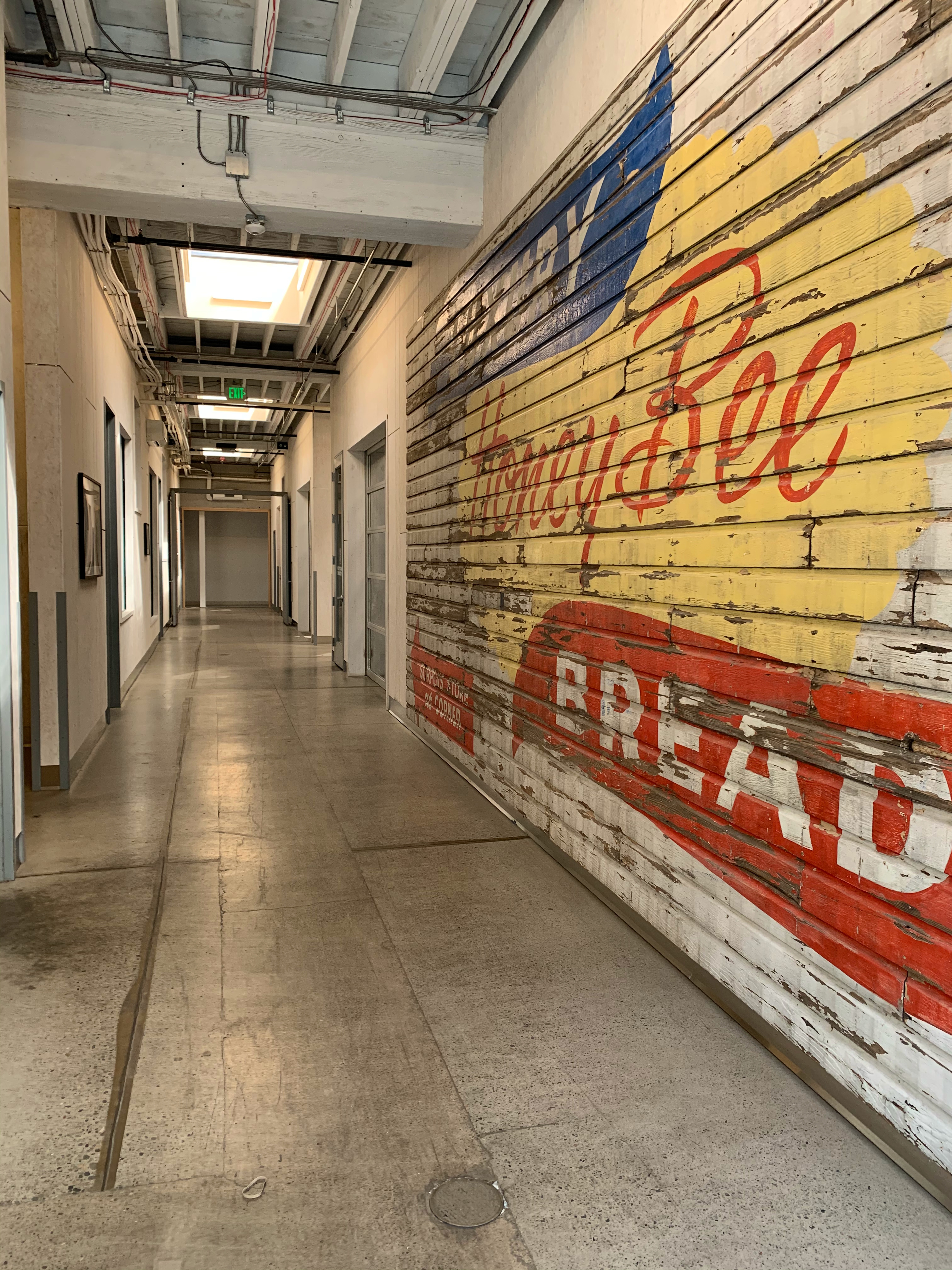
Geller and her colleagues are disappointed, especially given their interest and track record of adaptively re-using and renovating older buildings. In southeast Portland at SE 14th and Stark, O’Cardinal updated the 1929 Luxury Bread Building, carrying forward aspects of its history—including old siding, photos of the old bakery operation and family photos and stories from the former owners. Here’s a photo from inside Luxury Bread showing how O’Cardinal used a former painted mural there:
Repurposed wall siding inside the Luxury Bread Building recently restored by O’Cardinal Properties, 1403 SE Stark. Due to high levels of lead found in the Billy Rowe’s mural, something like this is not possible, according to O’Cardinal.
“We have a plan to take a hi-res photo and reproduce the image to use on the building to retain some of the heritage, “Geller continued.
“I know it is going to be hard for the neighborhood to see the boards come down,” she acknowledged, “but there is no feasible way for us to keep the mural in place, so it will be removed.”
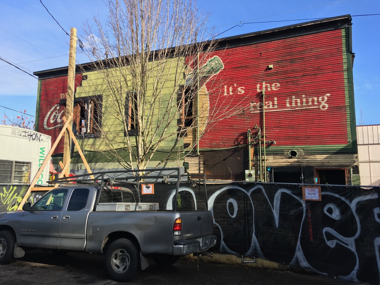
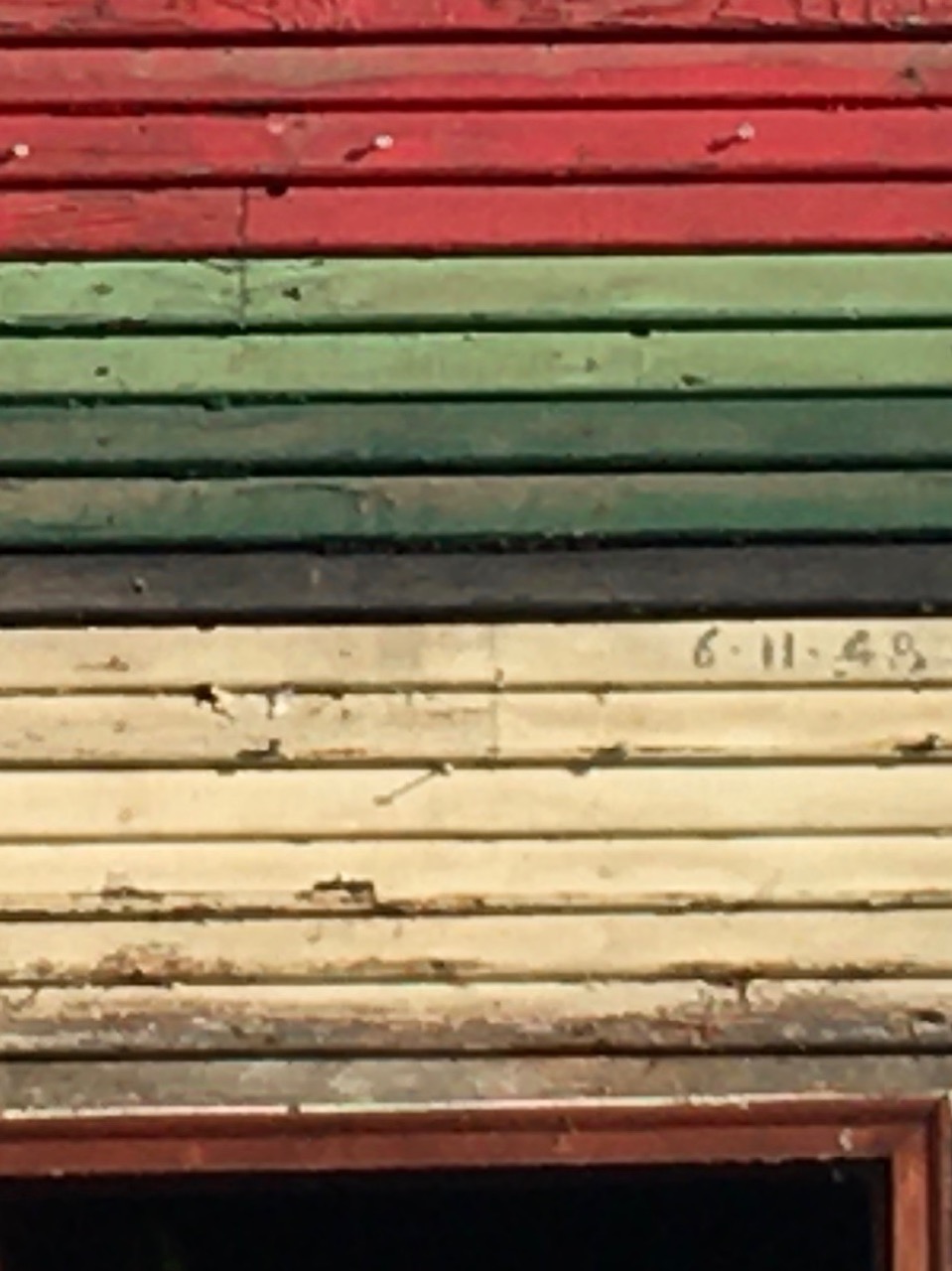
Like a giant postcard from 1946, the western wall of the former Billy Rowe’s Tavern reappeared yesterday at NE 29th and Alberta as workers removed shingle tiles during a major building renovation. When we visited yesterday morning, workers had exposed the vibrant colors of the Coca-Cola ad painted in 1946, but something more had yet to be revealed. Check it out:
The former Billy Rowe’s Tavern, in restoration November 25, 2020.
Naturally, we wondered about Billy.
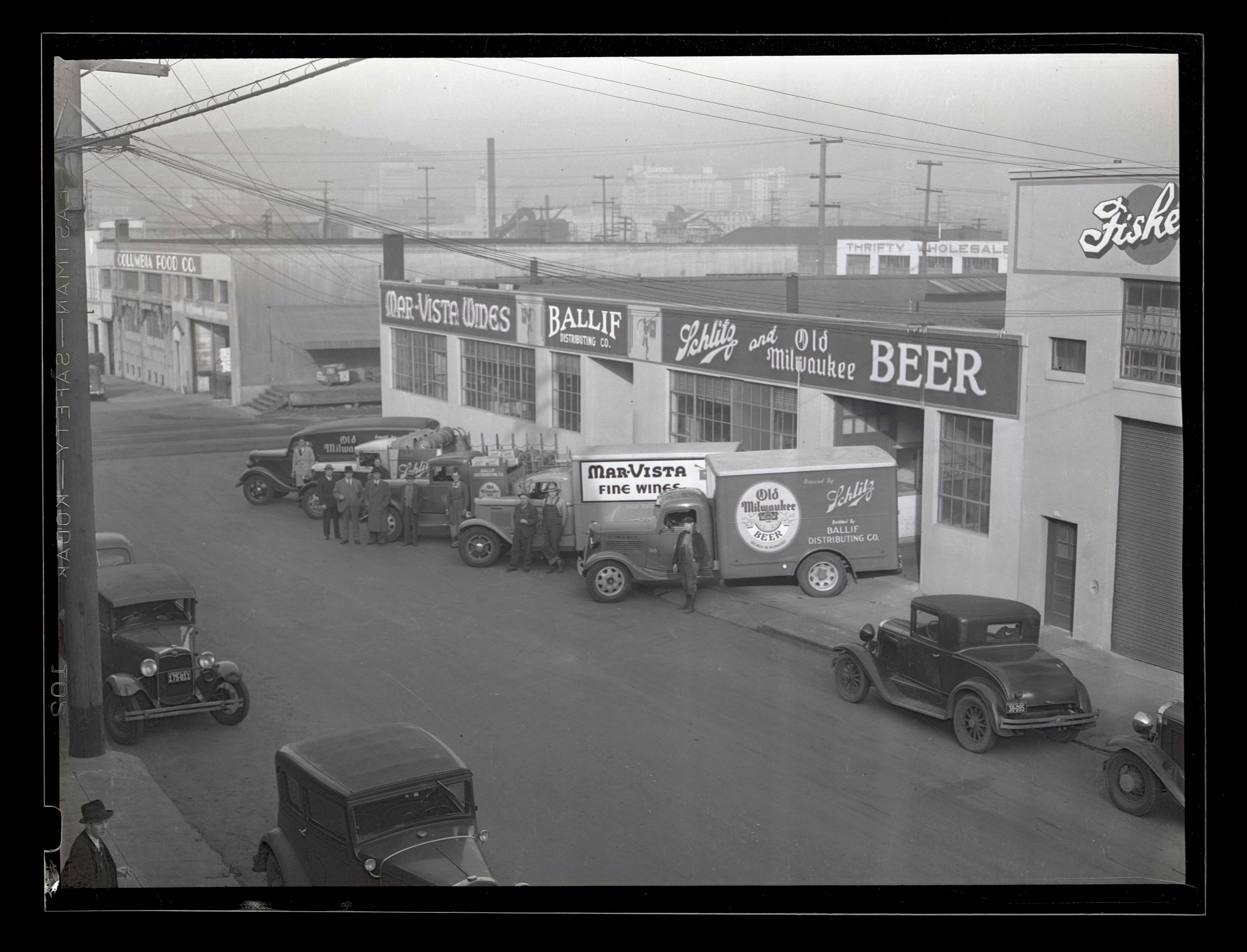
William Chauncey Rowe and wife Doris Isabelle Rowe opened the tavern at 2904 NE Alberta in 1943. Billy was a commissioner in the Boy Scouts, a member of the Portland Elks lodge and an active member in the Church of the Latter Day Saints. Doris was a member of the Elks Auxiliary. Before going into the tavern business, Billy was vice president of Ballif Distributing Company, a beer distributor based in southeast Portland.
Maybe he’s one of the overcoats here in this photo, from the incredible collection of Oregon Journal photos at the Oregon Historical Society. This photo is not specifically dated, but caption information indicates sometime between 1933-1941 (old car aficionados could probably pin that down, guessing late 1930s).
After leaving Ballif Distributing, Billy and Doris operated the tavern until their sudden death on the night of January 2, 1951 in a road accident north of Klamath Falls while returning to Portland. Newspaper reports describe a head-on crash in icy conditions. They were survived by two sons, Earl and Calvin.
The tavern appears to have passed out of Rowe family hands after that, but the name stuck (perhaps because it was painted in three-foot letters across the side of the building…the place was a local institution). In 1957, new owner Joseph Hoover was arrested on charges of promoting gambling on the premises and having a horoscope machine that made small payoffs to customers. Later that year, Portland City Council refused to renew Hoover’s tavern license.
Sometime after that–perhaps when the shingles went up on that west wall covering up Billy Rowe’s name–the place transitioned to Duke’s. Any AH readers able to share a story from the Billy Rowe era?
Update: On December 6th, the owners let us know the mural wall will have to come down due to high levels of lead paint. Click here to read more.
We always love to see layers of history being revealed in buildings and places we think we know. Check out this view from today’s walk up Alberta. Here we are at the southeast corner of Alberta and NE 29th, the building that used to house Bernie’s Southern Bistro.
Looking at the west side of the building from NE 29th. Sunshine!
Workers were carefully removing the green shingles, exposing a huge advertisement for the real thing painted directly onto the original shiplap siding.
According to the permit, it looks like the building is getting a complete renovation, with all interior walls, stairs and fixtures on both floors coming out; construction of a new stair, an upgrade to the old storefront and a complete seismic upgrade. Big job.
Built in 1921-1922 by D.L. Duncan, the building housed multiple businesses in its early days: a repair shop, a shoe store, a print shop. In its middle years and most recently it’s been a place to meet for a drink or a meal. From about 1940 until the late 1960s, it was Billy Rowe’s Tavern and then Duke’s Tavern before becoming Bernie’s Bistro.
Small lettering just below the real thing suggests this advertisement was from the Billy Rowe’s era. Can you read the lettering? Looks like June 11, 1948. We know a few sign painters and will ask around for insights…there’s more to this story.
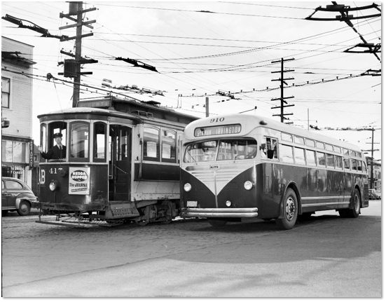
Just for fun–and you’ll be forgiven for being distracted by what’s in the foreground–here’s another view of the same building. Yep, that’s the corner of Billy Rowe’s Tavern there on the left by the streetcar, on February 3, 1948, at NE 29th and Alberta. The photo was published in the Portland Transit Company’s 1947 Annual Report to illustrate the end of an era. The caption: “Walt Baker, trolley skipper since 1911, greets Merritt Lutman, pilot of a new Mack bus.”
A few months back we participated in Concordia Conversations, a program about how change has affected Northeast Portland neighborhoods. It was a helpful and provocative gathering involving multiple generations, cultures and perspectives. Our message—as you might guess—was that this has always been a place of change.
Program host, neighbor and artist Jordana Leeb shared a great 25-minute documentary about how recent changes have affected her part of the Concordia neighborhood, which we recommend (you can watch it here).
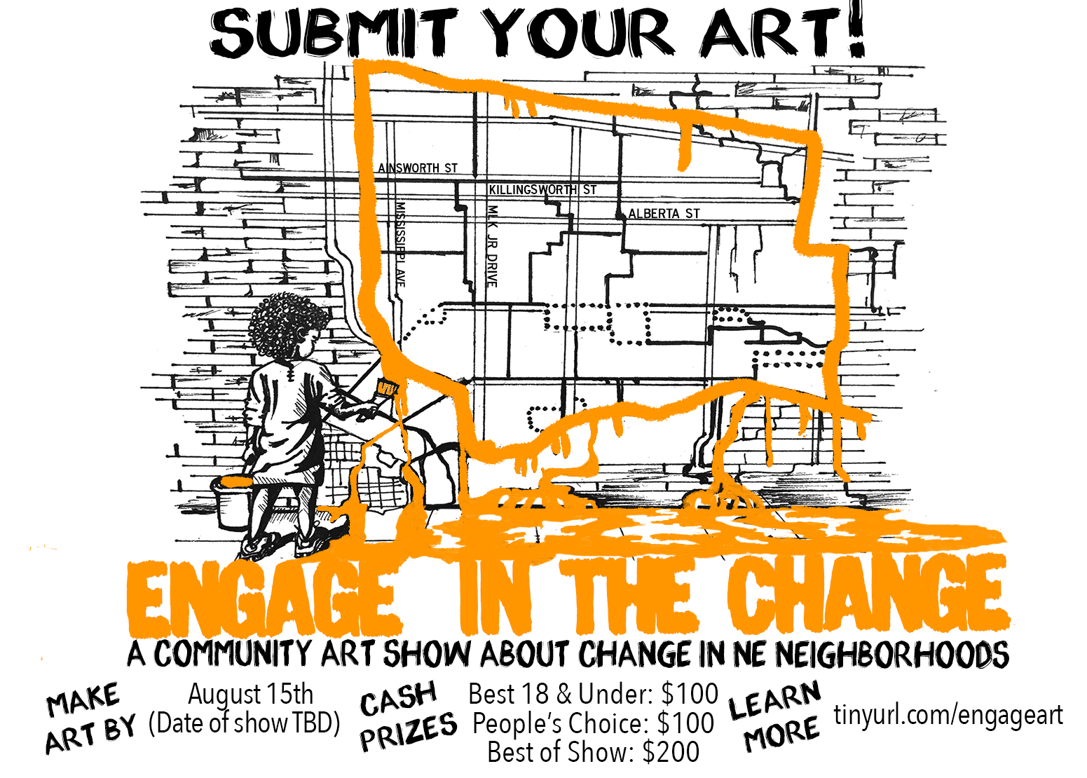
Continuing to build on the theme this summer, Jordana is curating a community art show called “Engage in the Change.” For now, it will be virtual but later this summer and fall (think Phase 2 opening) she’s hoping to exhibit the art somewhere in the neighborhood.
She’s asking for creativity from you and your family members–art, poetry, music–to explore the topic of neighborhood change. And there’s a chance you might even win some $ for your submittal.
Here are the guidelines:
Artwork can include visual art of any kind, written poetry, spoken word, video or music. Cash prizes are available (and there’s a category with a $100 prize for artists under age 18).
Art should explore what community means; how our community has changed; how neighborhoods bring us together (or keep us apart); changes you have seen and how they have affected you; what makes us resilient.
Deadline for submittal is August 15, 2020.
Here’s a link for more information about this community art show. Plenty of time yet for your creativity, and it would be great to see a bunch of submissions from young people!


