Planning for spring and summer season guided history walks is underway: I’ll be leading four walks for the Architectural Heritage Center through Northeast Portland neighborhoods. Registration (and fee) with AHC is required for these, and they’ll send you meet-up details as well.
Coming right up on Friday, March 6th at 5:00, I’m doing a free program at the Oregon City Library looking at Portland’s historic love affair with the Willamette River: Windemuth and Bundy’s: Where Portland Played in the River. The OC Library requests registration (which is free!).
Just an FYI, I’m always glad to consider leading walks and programs for groups interested in exploring local history. Let’s talk if you’re interested. Meanwhile, have a look at the calendar:
Saturday, May 30, 2026 at 10:00 am – Beaumont Neighborhood History Walk
One of Northeast Portland’s signature planned neighborhoods, Beaumont—“the beautiful mountain”—was platted in 1910, had its own named school, business district and streetcar route, and was home to one of Portland’s wealthiest and most powerful families that built a compound for its seven children. Join me for a walk along Alameda Ridge that ties these stories together and explores 116 years of neighborhood development. Registration link.
Saturday, June 6, 2026 at 10:00 am —Wilshire Neighborhood History Walk
Northeast Portland’s Wilshire neighborhood has long been tied to its neighbor Beaumont. But its history and development followed a very different trajectory. On this Saturday morning stroll, we’ll walk through a planned neighborhood that was never developed, explore multiple attempts to create Wilshire Park (which almost failed!), and line up with then-and-now photo points that show dairy pasture and forest stands at the heart of today’s residential neighborhood. Registration link.
Tuesday. June 30, 2026 at 10:00 am —Alameda Neighborhood History Walk
This Tuesday morning walk will explore the connections between past and present that shape the Alameda neighborhood we know today. This 90-minute stroll will cover just over a mile with multiple stops focusing on pre-development conditions, planning and construction of the neighborhood, the Broadway Streetcar, architectural house styles, and stories of local interest. Most of this walk is on flat terrain other than a gradual stretch that ascends the Alameda Ridge. Registration link.
Tuesday, July 14, 2026 at 10:00 am —Vernon Neighborhood History Walk
Come explore the layers of history in the Vernon neighborhood, from development of Alberta Park, to the fall and rise of neighborhood schools, to patterns of redlining from the 1930s-1950s, the presence of dairies, a much-loved old synagogue, a popular streetcar and a street full of small businesses. We’ll walk back in time to understand the how legacies of the past have shaped the neighborhood of today. Registration link.
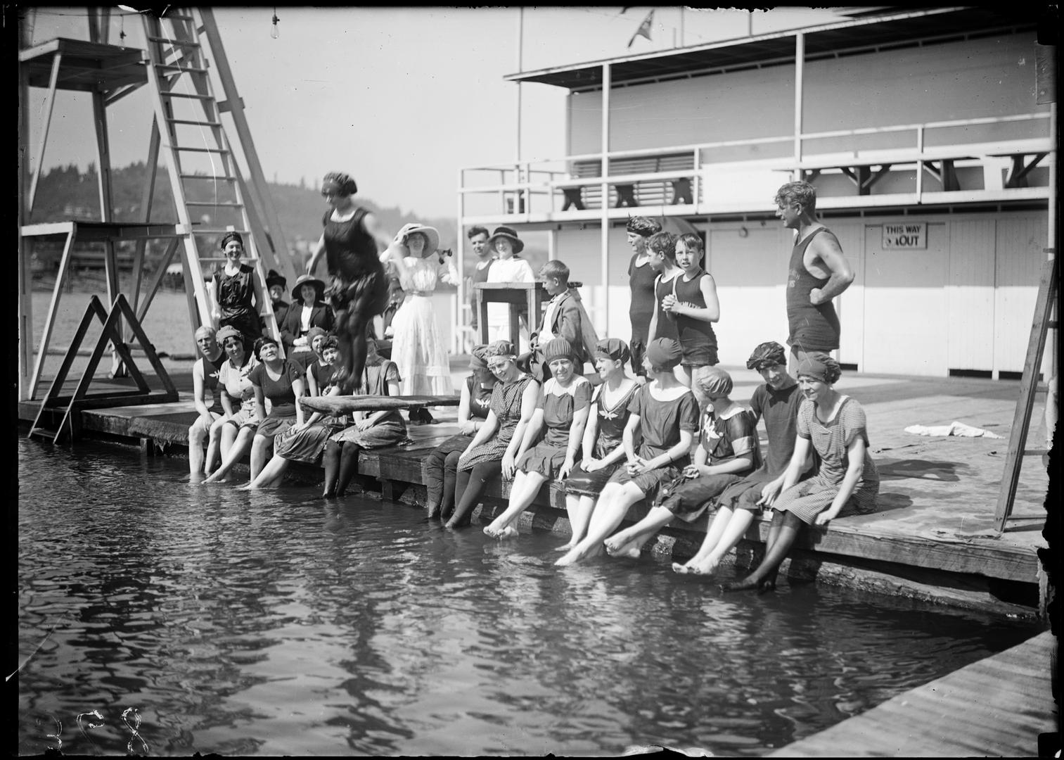
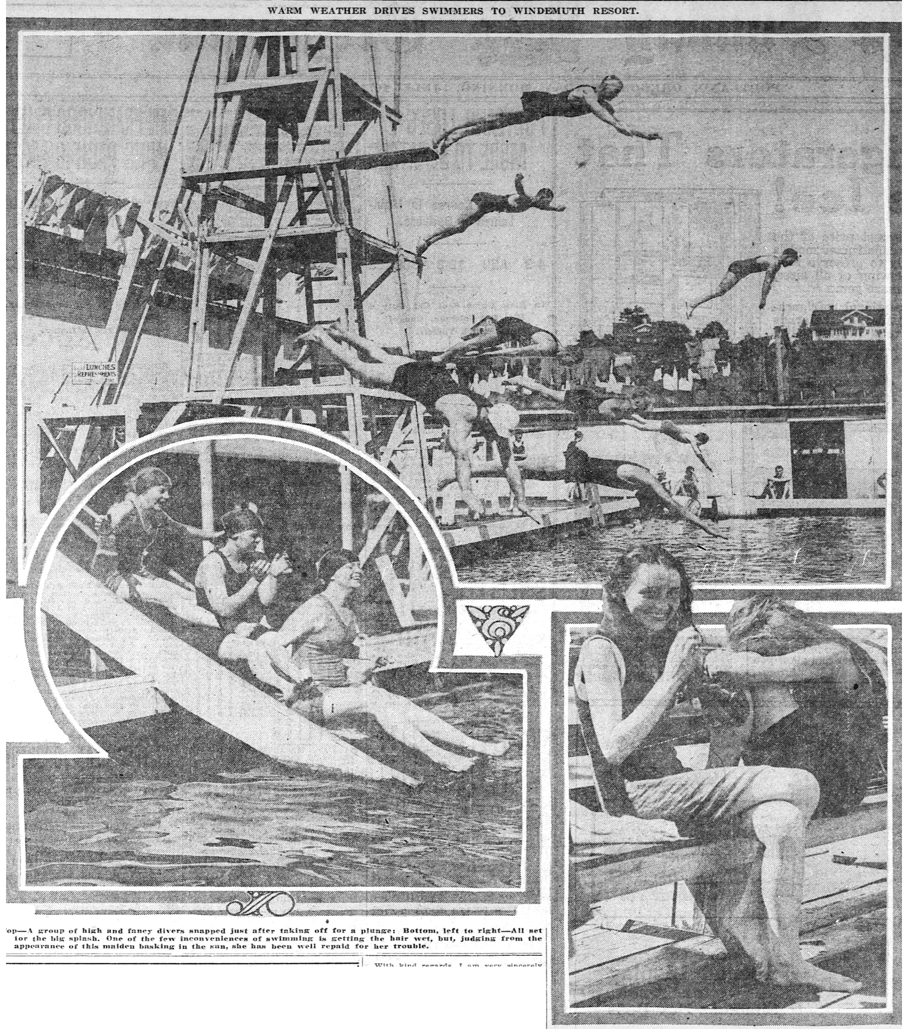
Swimmers at Windemuth. Angelus Studio photographs, 1880s-1940s, University of Oregon, Oregon Digital. PH037_b012_AG00052
News just in from the Oregon Encyclopedia that our entry on Portland’s once-great swimming platform afloat in the Willamette River known as Windemuth, and its on-shore predecessor Bundy’s Baths, has been published. Here’s a link, go take a look. If you haven’t seen the Oregon Encyclopedia before, better bookmark it. The OE is a great source of information on all things Oregon.
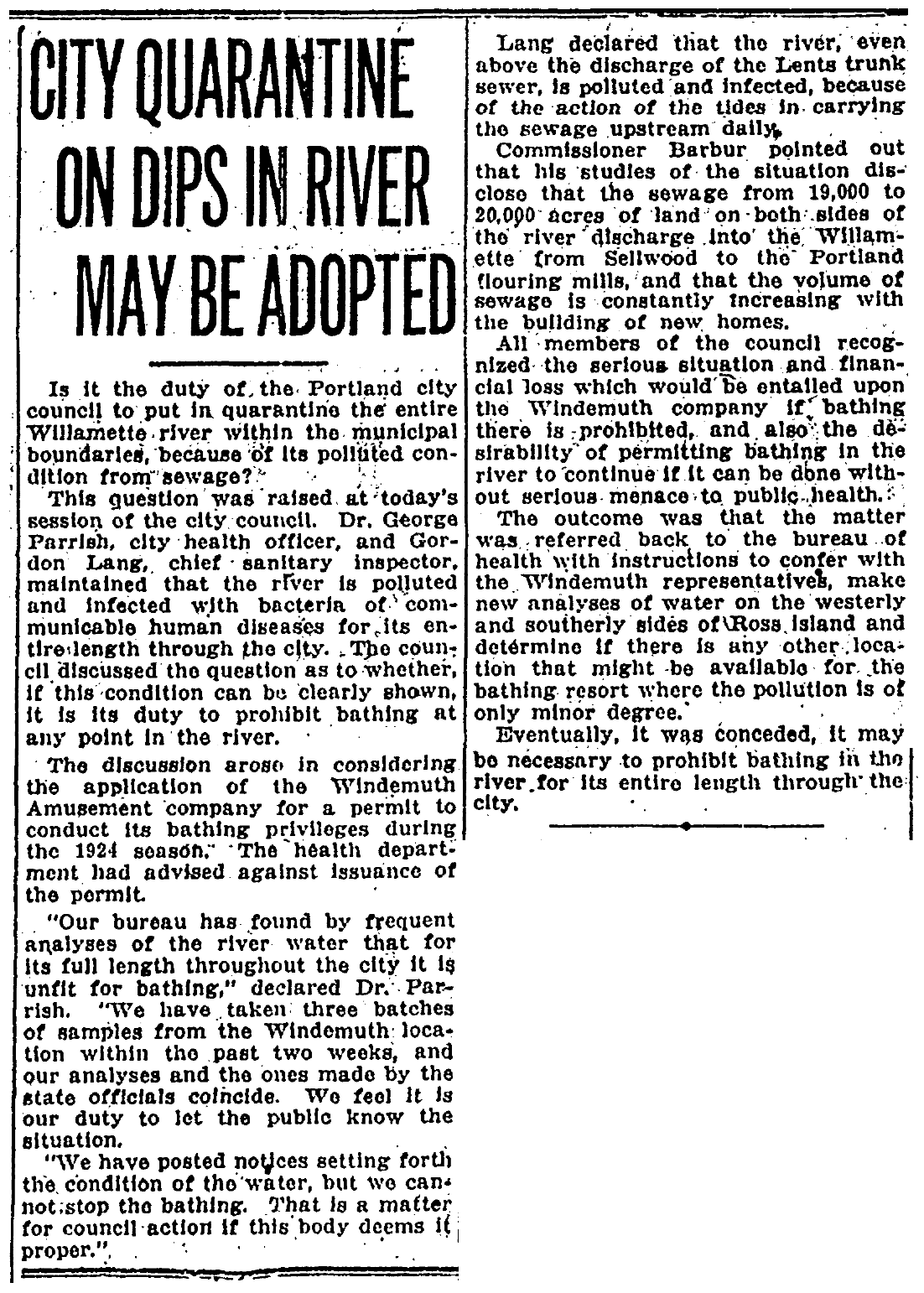
Prior to the mid-1920s, during days like the recent heat wave, this stretch of the Willamette River just downstream from Ross Island was a haven for Portlanders trying to stay cool and have fun. In July 1924, swimmers were ordered out of the river due to serious health and water quality conditions due to the accumulation of raw sewage routinely discharged into the river. An eerie parallel to the recent blue-green algae outbreak in the same area.
If you’re hungry to read more about Bundy’s and Windemuth, check out our past posts on the topics:
It’s not too late to sign up for one of the programs we’re doing for the Architectural Heritage Center this summer, kicking off this Saturday morning with a program at AHC focused on Portlanders’ historic connection with the Willamette River.
Saturday, May 10th from 10:00-11:30 we’ll explore the colorful history of Portland’s southeast waterfront in the vicinity of Ross Island, where Portlanders flocked to two hugely popular swimming and waterplay venues: Bundy’s Baths and Windemuth. We’ve written about these here on the blog and will be delivering a program with photos, maps and stories that help bring these former Portland water recreation mainstays back to life. Program based at AHC, 701 SE Grand, Portland.
Vernon Walk – Thursday, June 5th from 6:00-8:00 p.m. we’ll be leading a history walk that explores the Vernon neighborhood, from development of Alberta Park, to the fall and rise of neighborhood schools, to patterns of redlining from the 1930s-1950s, the presence of a dairy, a much-loved synagogue and a street full of small businesses.
Alameda Walk – Wednesday, June 11th from 10:00-Noon This walk through the Alameda neighborhood will include insights about pre-development conditions, planning and construction of the neighborhood, the Broadway Streetcar, home construction and architectural styles and points of local interest including the story behind Deadman’s Hill and the 1920s uproar over the former Alameda Park Community Church.
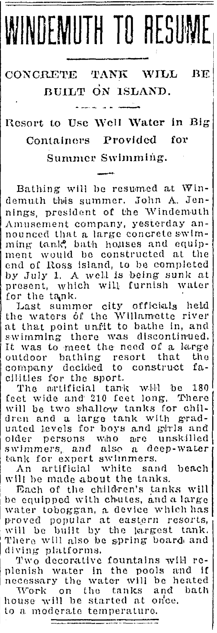
It’s been over a year since we’ve written about Willamette River swimming at Windemuth and at Bundy’s Baths on the eastbank in the vicinity of Ross Island. There’s an important anniversary coming up for Windemuth, plus we’ve learned a few more things (and found some more photos), so it’s time to say a bit more.
If you don’t yet know about Windemuth and Bundy’s Baths, be sure to follow those links and while you’re doing that, check out this great set of old photos and memories about canoeing the Willamette downtown during the summer of 1919. We’ve been haunting these places and the archives this summer to learn more about the hold they had on Portland’s soul, which was something.
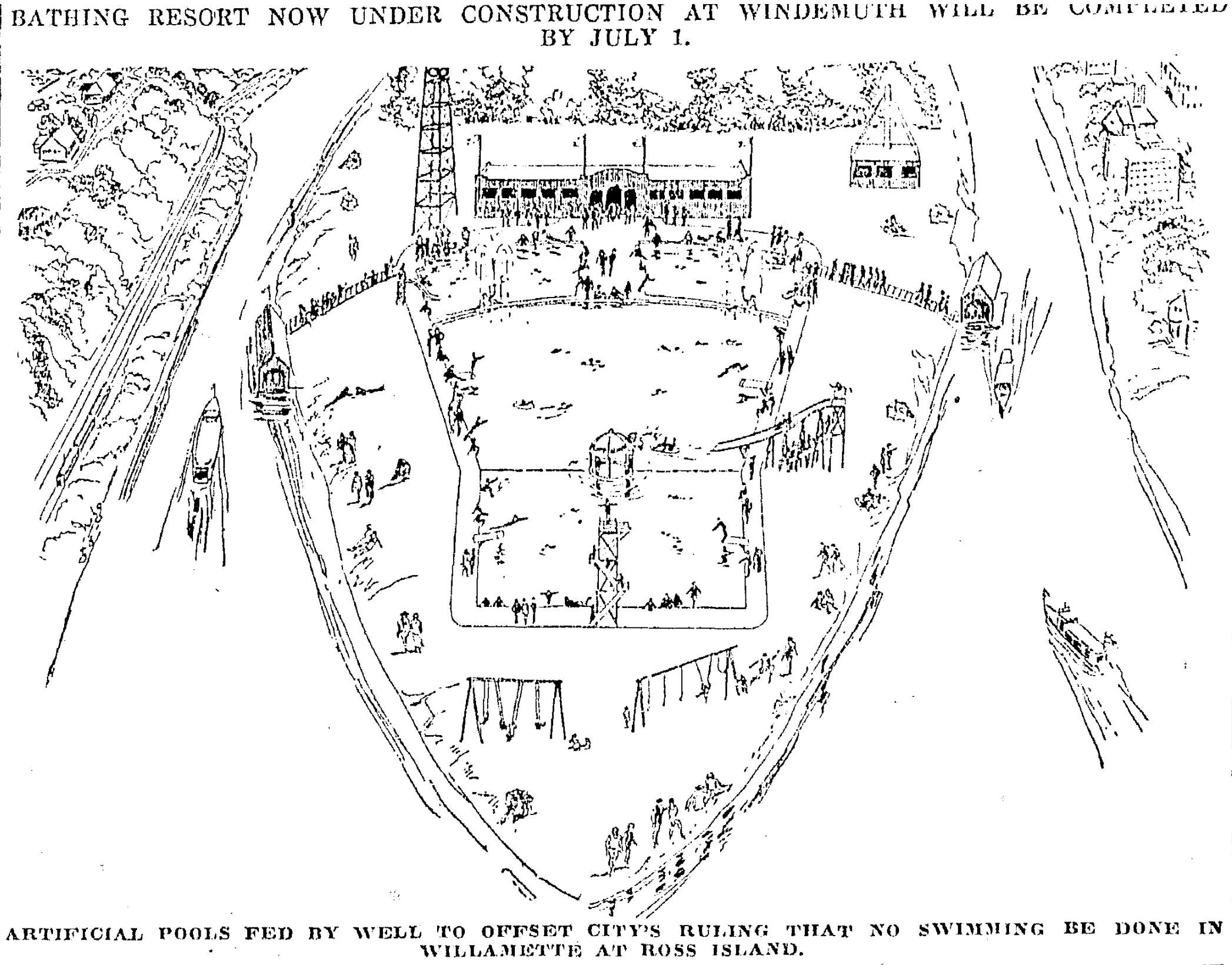
Briefly: Windemuth was a huge two-story floating swimming tank, diving venue and dance floor anchored off the north end of Ross Island (before the bridge, which was built in 1926) that held more than 500 people. It was so popular in the 19-teens and 1920s there were times it rode low in the water, packed with so many people.
Swimmers at Windemuth. Angelus Studio photographs, 1880s-1940s, University of Oregon, Oregon Digital. PH037_b012_AG00052
Earlier–dating back into the 1890s–Bundy’s Baths was the place to meet your friends, rent your swimming togs, and play in the water at river’s edge.
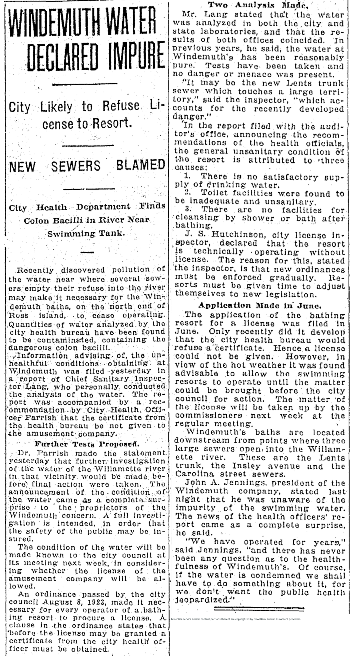
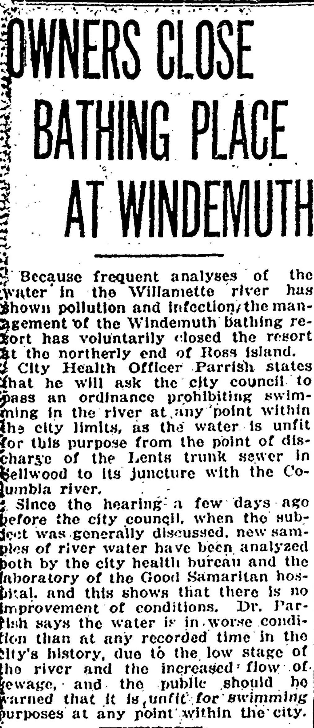
To the infamous anniversary: 100 years ago this month, Willamette River water was so polluted with sewage and human waste that City Health Officer George Parrish recommended Portland City Council pass an ordinance banning all Willamette River swimming in Portland. At the time (and up until 1952) all of the city’s raw sewage poured directly into the Willamette from nine major sewer outfalls. By 1924 it was a serious human health problem, as well as a wider environmental menace.
The topic came before council in mid-July 1924 because Windemuth was required to be relicensed in order to open to the public, a process that involved gaining an endorsement from the City Health Officer. The giant floating swimming platform had already opened that June to much fanfare, with relicensing just a bureaucratic box to check.
The place had become an institution: when Portlanders thought about being in the water (which in those days they did frequently) their first thought was the Willamette and Windemuth. It was the premier swimming venue in the city, the place for diving competitions, as well as being a top-flight social scene (think dancing at night to a live orchestra on a floating dance floor in the middle of the river).
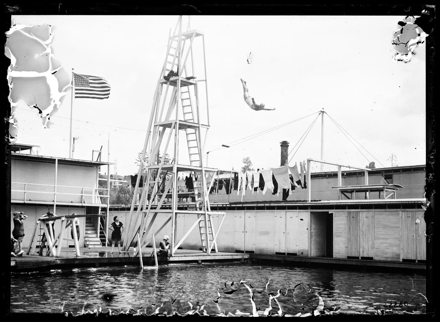
Diving at Windemuth. Angelus Studio Photographs, 1880s-1940s, University of Oregon, Oregon Digital. PH037_P362
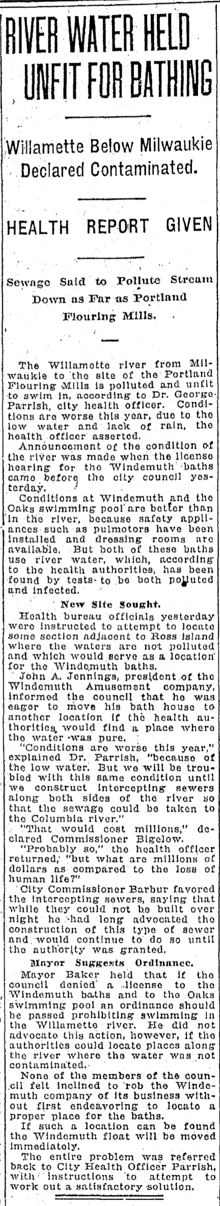
City Health Officer Parrish and Chief Sanitary Inspector Gordon Lang brought their findings into council on the day of the relicensing hearing: record-breaking levels of fecal coliform bacteria and low levels of dissolved oxygen. Beyond just not endorsing Windemuth, Parrish recommended council craft an ordinance prohibiting all river swimming.
Of course, banning swimming in the Willamette in Portland would mean the end of Windemuth, and as The Oregonian reported “None of the members of the council felt inclined to rob the Windemuth company of its business…” So council punted, ordering Parrish and Lang to take another set of samples to verify the earlier readings.
Nine days later, the relicensing question was back before council, with Parrish and Lang reporting levels hadn’t gotten any better. Between a rock and hard place now, council deferred action on relicensing Windemuth and directed Parrish and Lang to confer with Windemuth owner John Jennings to see what could be worked out regarding finding an alternative location. Council also raised the existential question of whether or not it even had the authority or the duty to ban swimming.
From the Oregon Journal, July 24, 1924
But Jennings saw the writing on the wall. People had lost confidence in the river. Record-breaking levels of bacteria in the Willamette were in the news every day. Parents told their kids not to swim in the river. And as water levels dropped in late July and temperatures rose, the Willamette didn’t look or smell very enticing.
On Sunday, July 27, 1924, Jennings announced he was voluntarily closing Windemuth. It was the end of an era. Portlanders got out of the river in the summer of 1924, mourned the loss, and stayed out until not so long ago.
From the Oregon Journal, August 5, 1924
100 years later, a resurgence of interest in Willamette River swimming and much healthier and desirable conditions now beckon Portlanders back into the water, reminding us about what was lost, what has been gained back, and how we must never again take our river for granted.
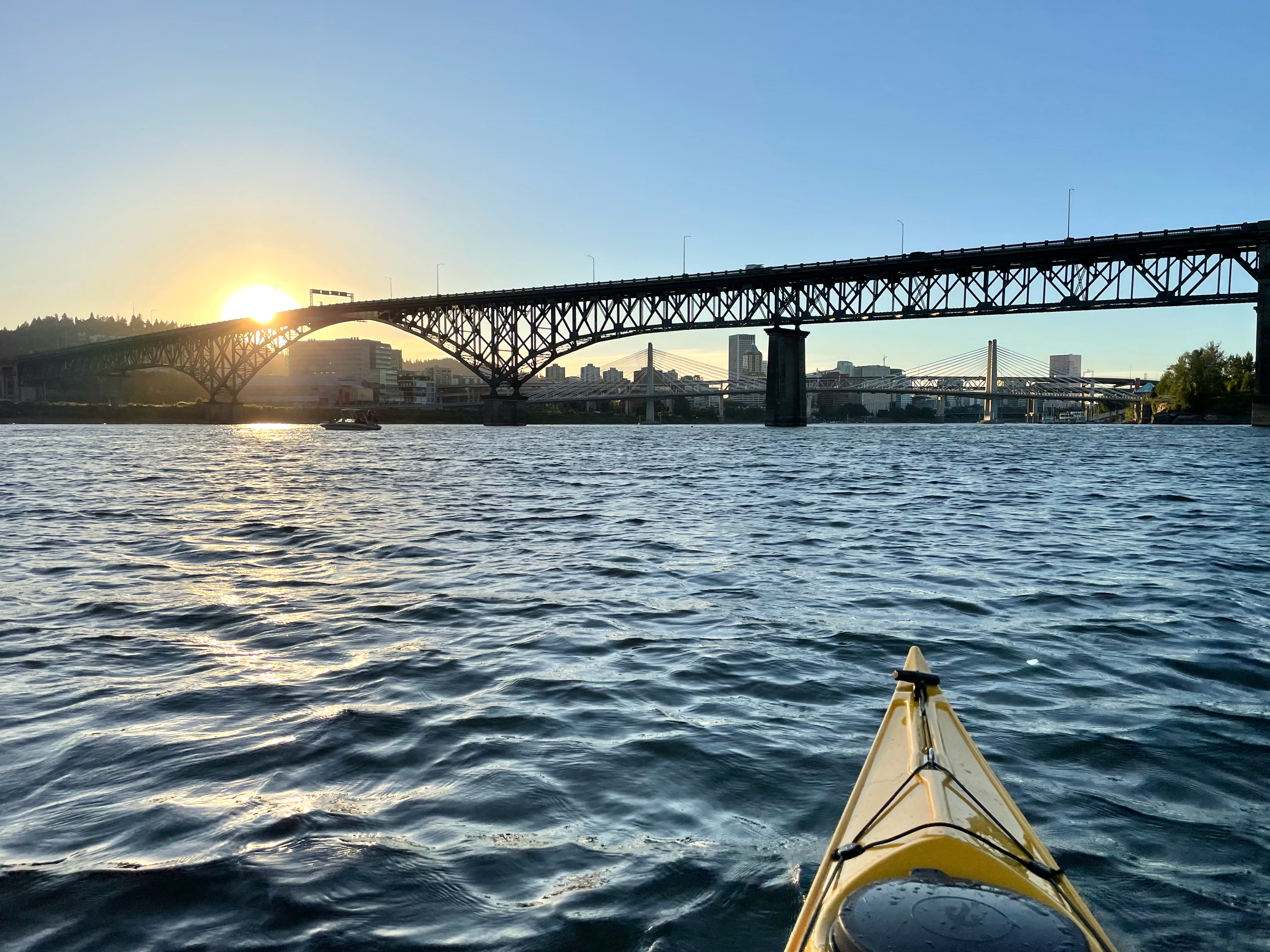
Willamette River sunset near the former location of Windemuth.
We’ve come across another clue that helps us visualize the area on the east bank of the Willamette River opposite the northern end of Ross Island, home to the most popular swimming hole in early Portland. This spring we’ve been writing and thinking about Bundy’s Baths, which we discovered following a thread of interest spun by an album we received of 100-year-old photos of canoeing the Willamette in downtown Portland.
From the 1890s until the mid 19-teens, Bundy’s was an important eastside portal to the river, regularly hosting more than 1,000 swimmers on a hot summer day. Changing facilities, a snack bar, diving platforms, docks to hang out with friends and an enclosed swimming area made up the “bath house” and were afloat along the bank, anchored to piers that held them in place.
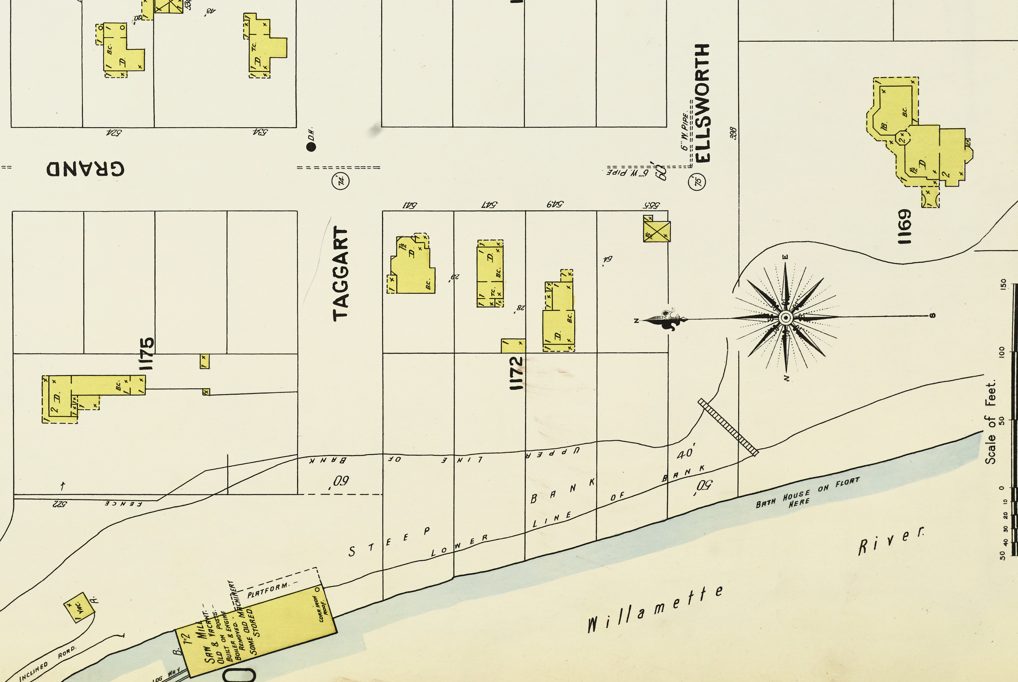
Here’s a detail from the Sanborn Fire Insurance Company map of this area from 1901. In these early days, Sanborn mapped 12,000 U.S. communities to help fire insurance underwriters evaluate risk by showing the location and type of structures, water mains and hydrants that were present. Today, we love them because they are a snapshot in time and allow us to visualize places in that era. Have a good look at this one and then we’ll discuss.
Detail from Plate 127, Sanborn Map Company, 1901. Click to enlarge. This and other Sanborn maps of the vicinity can be accessed here through the Library of Congress.
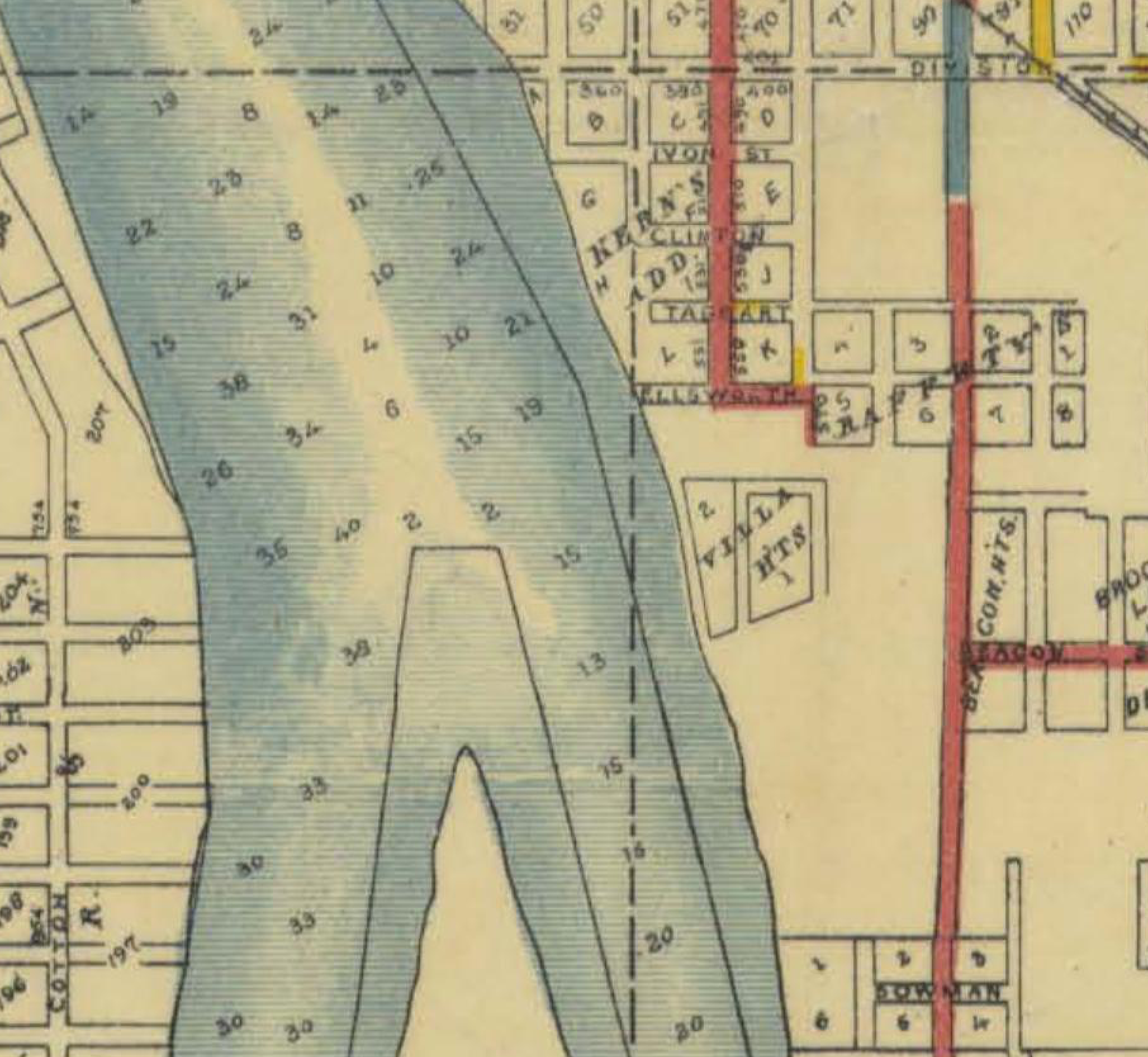
Remember that construction of the Ross Island Bridge in 1925-1926 completely remade this landscape: the bridge essentially follows the path of Ellsworth Street, which was renamed Woodward in 1910.
Interesting to note the contour lines and the steepness between the upper line of bank and the lower line of bank, a slope angle that remains today in that area. Back then, people used a stairway to get up and down from the river.
Advertisements to Bundy’s—and later to the mid-river swimming platform and dance floor known as Windemuth—directed visitors to take the Brooklyn streetcar to the foot of Ellsworth Street where they could proceed to the water…presumably down those stairs.
Note that the structures were afloat. This makes sense. Periodic news stories about spring high water reported on Bundy’s buildings and other floating residences periodically being washed away downstream. It was a temporary community, of necessity.
The structures to the north were old then, holding disused machinery from the Inman-Poulsen Mill. The main portion of the mill was located downstream farther north along the bank, where the river was deeper and ocean-going freighters could tie up to take on lumber from the mill. Note how Sanborn observed the roof of one old building was corrugated iron roofing…always thinking fire risk.
The large house in the upper right is still standing today: the Poulsen House, built for Johan Poulsen, partner with Robert D. Inman, who had a very similar house nearby at SE 6th and Woodward that was demolished in 1958 to make room for a parking lot. The presence of the Poulsen house in relation to where the swimming took place helps us locate ourselves today.
If we could zoom out a bit on this Sanborn plate and look to the north, you would see all of the other east-west streets in the area—Grant, Sherman, Caruthers—essentially ended at the top of the bank (or ran into the Inman-Poulsen sawmill) where it dropped off to the river. We’d also see Stephens Slough (fed by Brooklyn Creek) which filled almost as far east as SE 10th Avenue that would flood whenever the river rose, where nothing was built, even though there were lot lines and streets.
There are more clues yet to find about this place, and maybe photos. We’ll keep looking.
This week, we’ve been thinking about Bundy’s: a placename attached long ago to a portion of the eastern bank of the Willamette River opposite Ross Island. We mentioned the name in our recent post about Windemuth, the floating dance floor and swimming platform anchored off the north end of Ross Island that was popular between 1914-1924.
From the Oregon Journal, July 29, 1911
Reporting in the local papers from the early 1900s referred to a swimming venue in this area called Bundy’s Baths and the name quickly became applied in a shorthand way to signify the general vicinity we think of today on the east side of the river just north of today’s Ross Island Bridge. Over the years, we’ve bumped into passing references to Bundy’s: for instance, George Asa Eastman, the lead architect for Oregon Home Builders, had a houseboat / secondary residence in this area in the early 1900s.
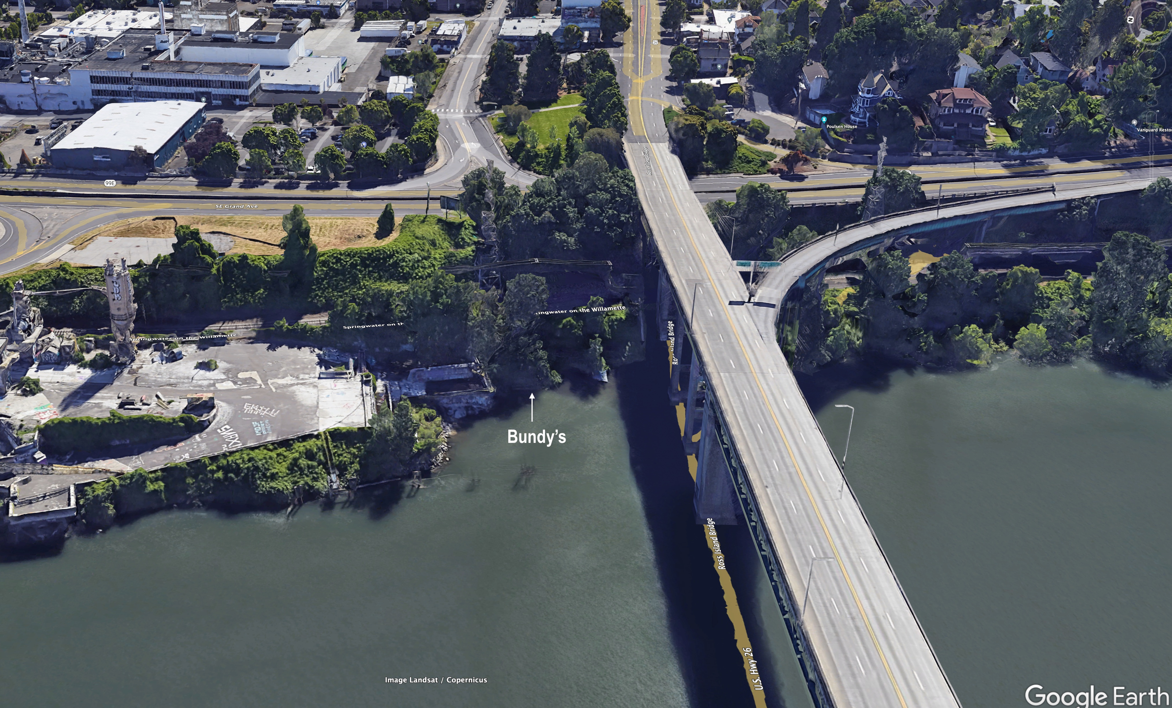
The vicinity of Bundy’s today, Google Earth photo. Click to enlarge.
So, while we’ve generally thought of this area as Bundy’s, we’ve never really known where the name came from.
Furthermore, because so much has changed there in the last 100 years (including construction of the bridge), we’ve figured Bundy’s was extinct both as a place and as a name. We were pleasantly surprised this week, following the Windemuth post, to hear from a reader with a question about “Bundys Landing,” referring to the area’s later industrial years as a log and lumber loading zone for the nearby Inman-Poulsen mill, and after that a processing site for Ross Island Sand and Gravel. Maybe others have heard someone talk about Bundy’s, though it has certainly disappeared from any living memory.
This made us curious for more: Who was Bundy? What was this place? Where was it exactly? What else was going on here? What does it look like today? We love questions like this.
From The Oregonian, January 20, 1908
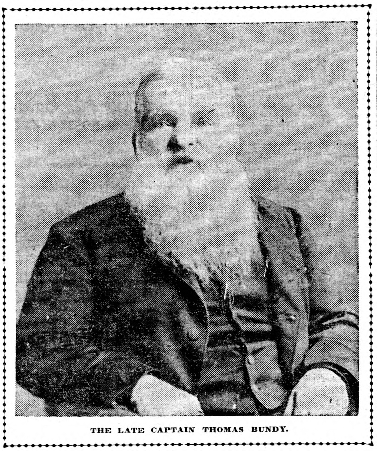
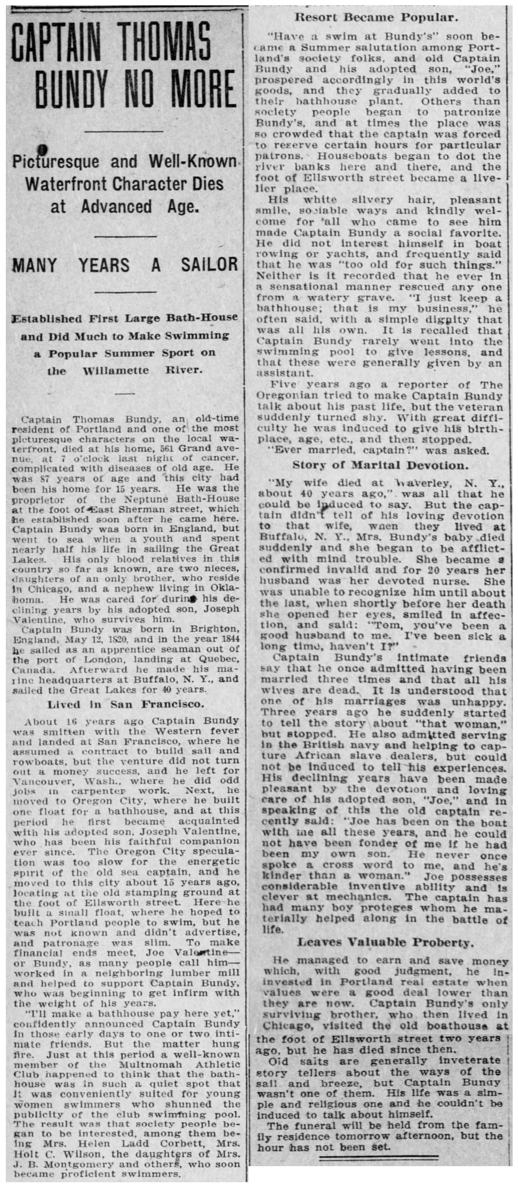
When he opened the eponymous bathhouse here in the spring of 1898, Thomas Bundy was in his late 70s, a British-born sailor, boat builder, real estate speculator and lover of everything related to swimming. He was known as “Captain Bundy,” though his days in a ship on water were mostly on the Great Lakes and well behind him. Reporting suggests Bundy was a quiet person, reluctant to talk about both his past (which included three marriages and various businesses), and his present, which included living on a nearby houseboat with Joe Valentine, who was like an adopted son. Bundy was a transplant to the Pacific Northwest, arriving in the early 1890s from San Francisco and living in Vancouver, Washington and then Oregon City before arriving in Portland.
His obituary from January 20, 1908 describes Bundy’s interesting life, and credits him as being a leading advocate for swimming in the Willamette River:
From The Oregonian, January 20, 1908
When it opened in late May 1898, Bundy’s vision for a swimming resort away from the downtown area drew immediate interest.
From The Oregonian, May 29, 1898
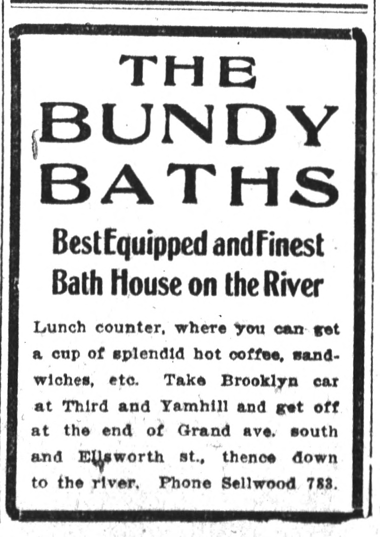
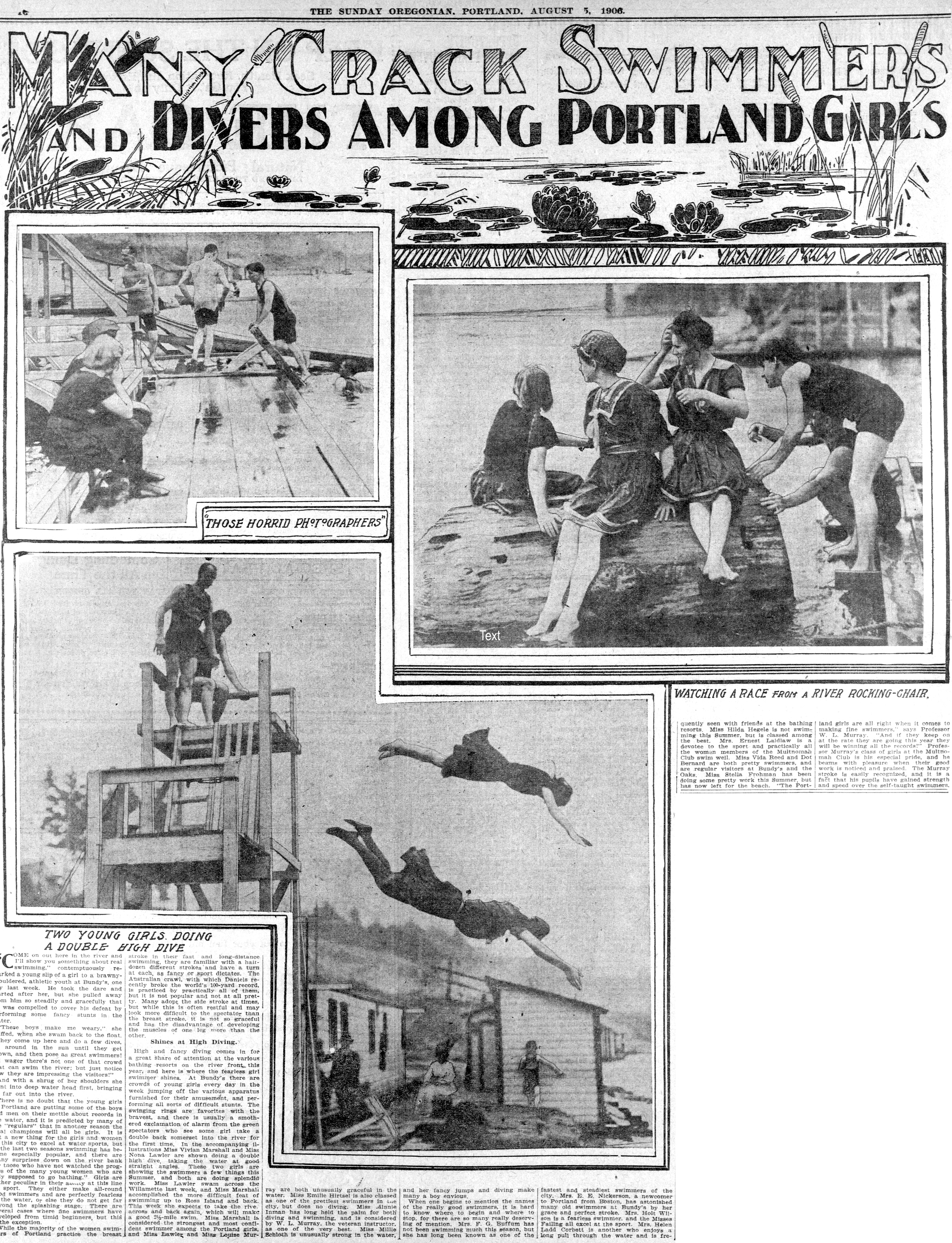
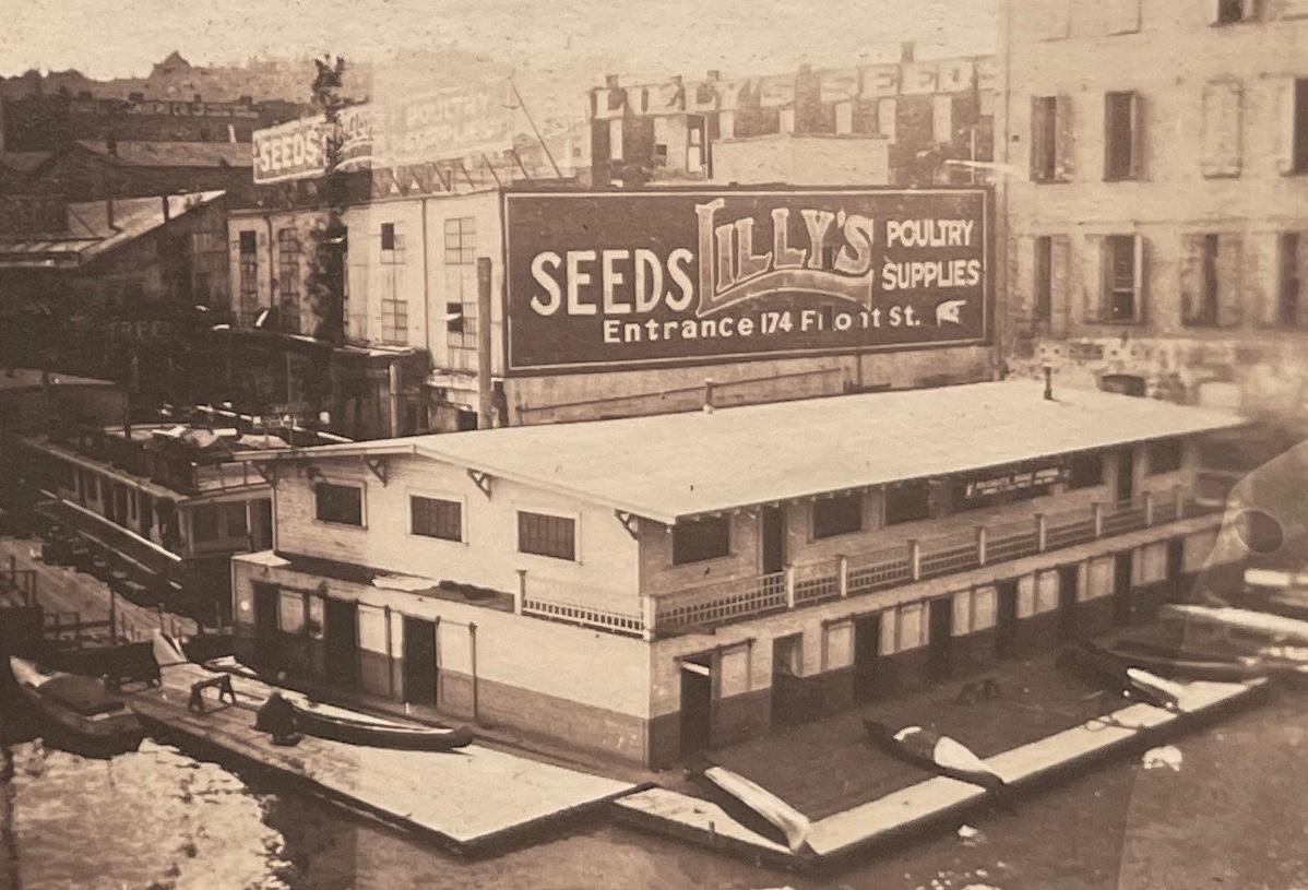
Members of the Multnomah Athletic Club began frequenting Bundy’s resort—which was also known as the Neptune Baths—and soon it became the place to go, particularly for girls and women. Swimming and diving competitions took place here and eventually the Portland Yacht Club relocated just downstream to be nearby. It was the center of gravity for river swimming in Portland. We know it was busy: The Oregonian reported Bundy’s rented out 1,300 swimming suits per day in August 1915 and that more than 40,000 people used the foot of Ellsworth Street each year in the 19-teens for landing and embarking on the river. News coverage was abundant.
Click to enlarge: From The Oregonian, August 5, 1906. Note the buildings and shoreline at Bundy’s in the diving photo above. Below, from The Oregonian on August 9, 1903(note the sketch of Captain Bundy presiding).
Bundy’s Bath’s appears to have been a collection of simple buildings for dressing, an enclosed area for swimming, a snack bar, and a set of diving platforms on the east bank of the river at what was the foot of Ellsworth Street. Here’s a map that puts this in context, and remember this is before the Ross Island Bridge, which came along in 1926. In 1910, Ellsworth Street was renamed Woodward Street.
Detail from the 1894 paving map of Portland. Bundy’s was located where Ellsworth Street met the river. The pink roadway indicates gravel.
The vicinity of Bundy’s at the foot of Ellsworth Street was a kind of jumping off place into this watery world: if you were out on the river in this area to have fun (or to live in one of the houseboats) you passed through here. A careful look at aerial photos from the 1920s and 1930s shows a solid line of houseboats from Bundy’s south along the east bank of the river well into the bend across from Ross Island, and even lining the eastern shore of Ross Island.
1925 aerial photo. Click to enlarge.
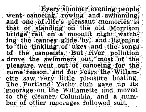
From 1900 until the early 1920s, Bundy’s was the epicenter of swimming in this stretch of the Willamette. But by 1925, Portlanders abandoned the river because it had become the main receptacle for the city’s raw sewage, and due to heavy industrialization on this side of the river.
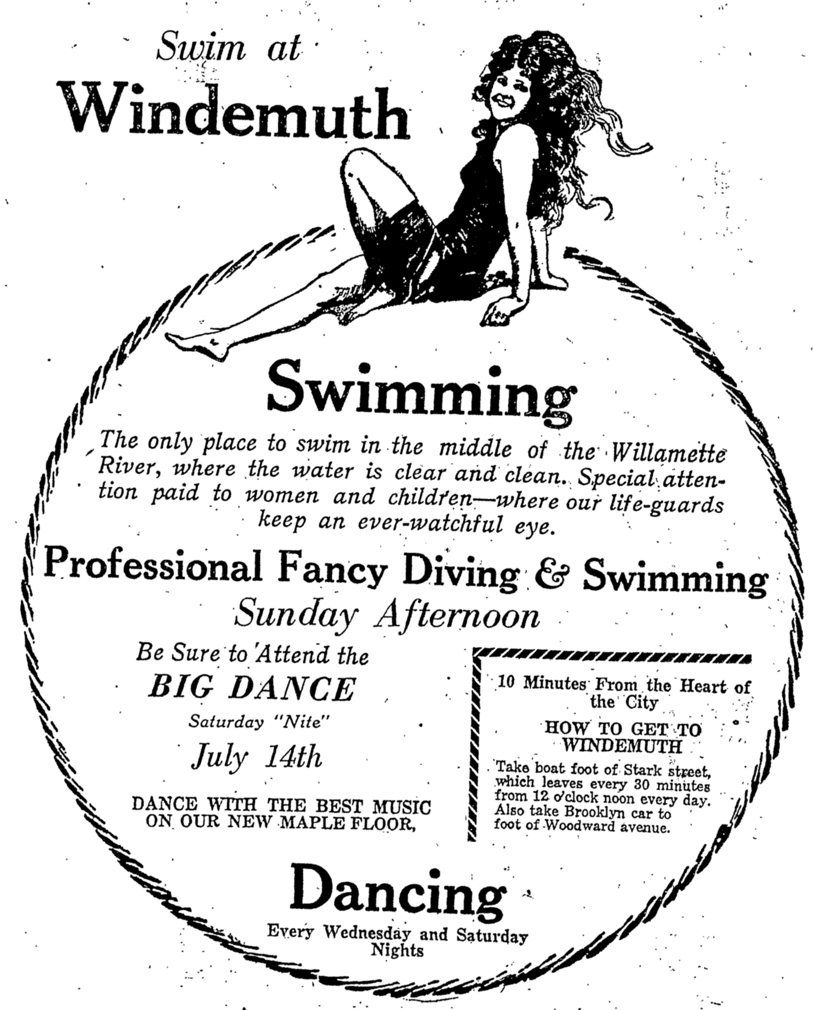
In fact, some credited the growing problem of raw sewage outfall as the motivation behind the swimming platform that became Windemuth, which opened in 1914 with the slogan “The only place to swim in the middle of the Willamette River, where the water is clear and clean.” The river banks were becoming clogged and foul-smelling with an awful mix of sewage and debris which could only be avoided by getting out in the current, in the middle of the river.
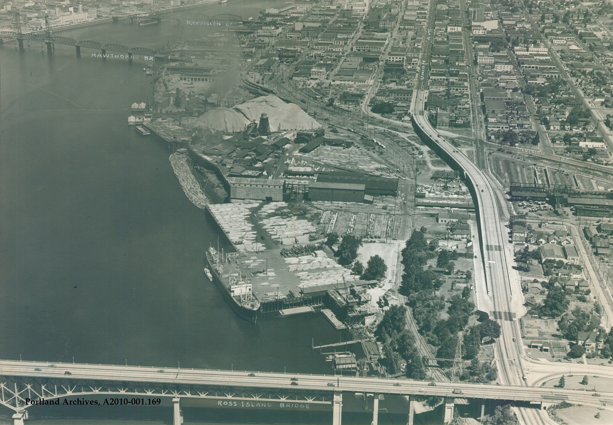
By 1919 the Bundy buildings on the eastern shore were sold and dismantled. In later years—long after those swimmers who loved this place had left—heavy piers and docks were constructed at the site where Bundy’s once stood to load lumber onto ships from the nearby Inman-Poulsen mill. Here’s a view from 1940:
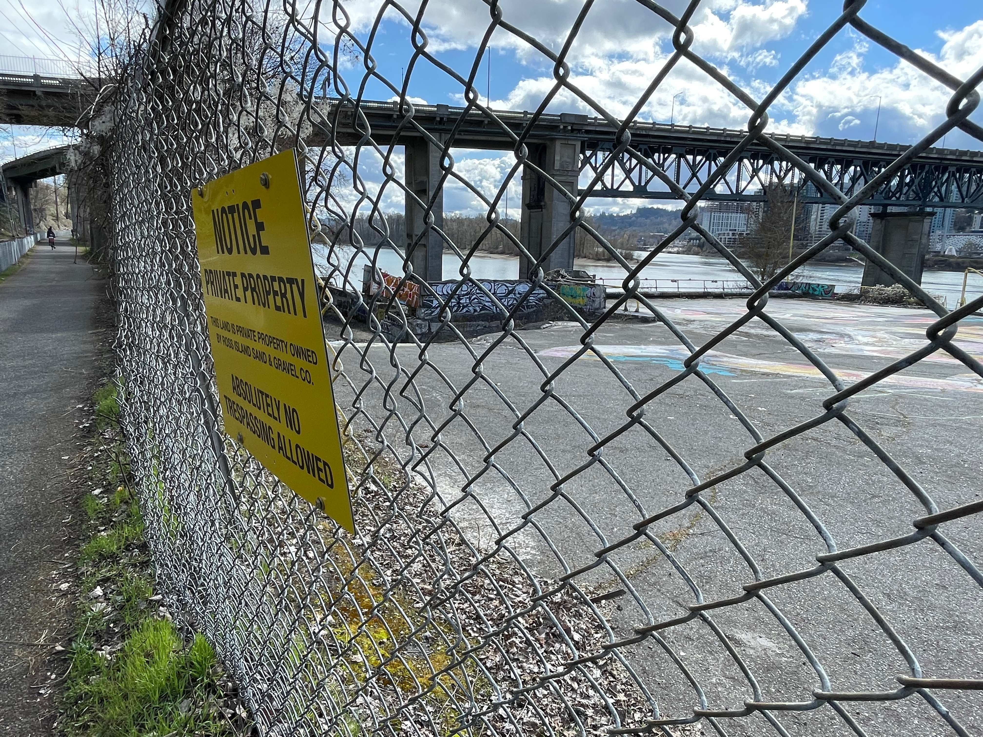
Today, the area is a desolate, post-industrial mass of graffitied concrete behind a tall, barbed wire security fence.
We’ve paddled and pedaled through this area hundreds of times and never knew these echoes from the past. Maybe you have too. Now we know. It’s time to get back out there in the kayak and remember what was a special place.
Last fall we shared amazing 100-year-old photos of the Willamette River. What a treat to be able to see and learn about river recreation in the early 1920s, including the rise of Windemuth, a popular swimming, diving and dancing resort that was afloat but anchored just downstream from the north tip of Ross Island.
From The Oregonian, July 10, 1921
We left this story on July 31, 1924, with the owner of Windemuth deciding to close the resort due to water quality concerns. Anyone reading the news stories in the hot-dry, low-water summer of 1924 could see the handwriting on the wall. Not a big surprise: much of Portland’s raw sewage was piped straight into the river. In mid-July, water tests had noted the presence of Bacillus coli in the water and City Council hinted at a swimming closure.
From The Oregonian, July 16, 1924
Ten days later, during City Council’s hearing on the operating license for Windemuth, the focus was on the looming swimming ban and the presence of sewers. Windemuth operator John A. Jennings signaled he was ready to move the floating resort anywhere the water was clear, but with Portland’s sewage system relying almost entirely on the Willamette River, there was no central alternative. Maybe build intercepting sewers that would shunt sewage to the Columbia River, wondered City Health Officer George Parrish, who had suddenly been called on to deliver a solution to swimming in the Willamette (see the last paragraph below).
From The Oregonian, July 25, 1924
The primary culprit was the Lents Trunk Sewer, a 5.2 mile tunnel, 56 inches by 71 inches in size, that emptied into the river at Harney Street, a stone’s throw from the diving boards at Windemuth. When it opened in August 1923, the line received sewage from about 30,000 homes as far east as Foster Road. In addition to the Lents Trunk Sewer, two additional lines—the Insley Avenue Sewer and the Carolina Street Sewer—also discharged into the river directly across from Ross Island and upstream from Windemuth. We’ll remember the boom in home construction and population in the early 1920s. It all had to go somewhere.
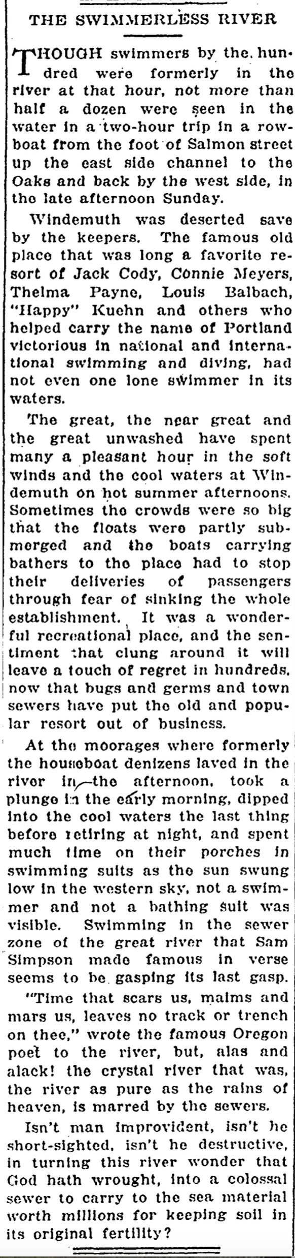
In early August after Windemuth was closed and swimming banned from the river, an editorial writer from the Oregon Journal spent Sunday afternoon rowing from downtown out and around Ross Island. The heartbreaking column on August 5, 1924 was an elegy for the river:
From the Oregon Journal, August 5, 1924
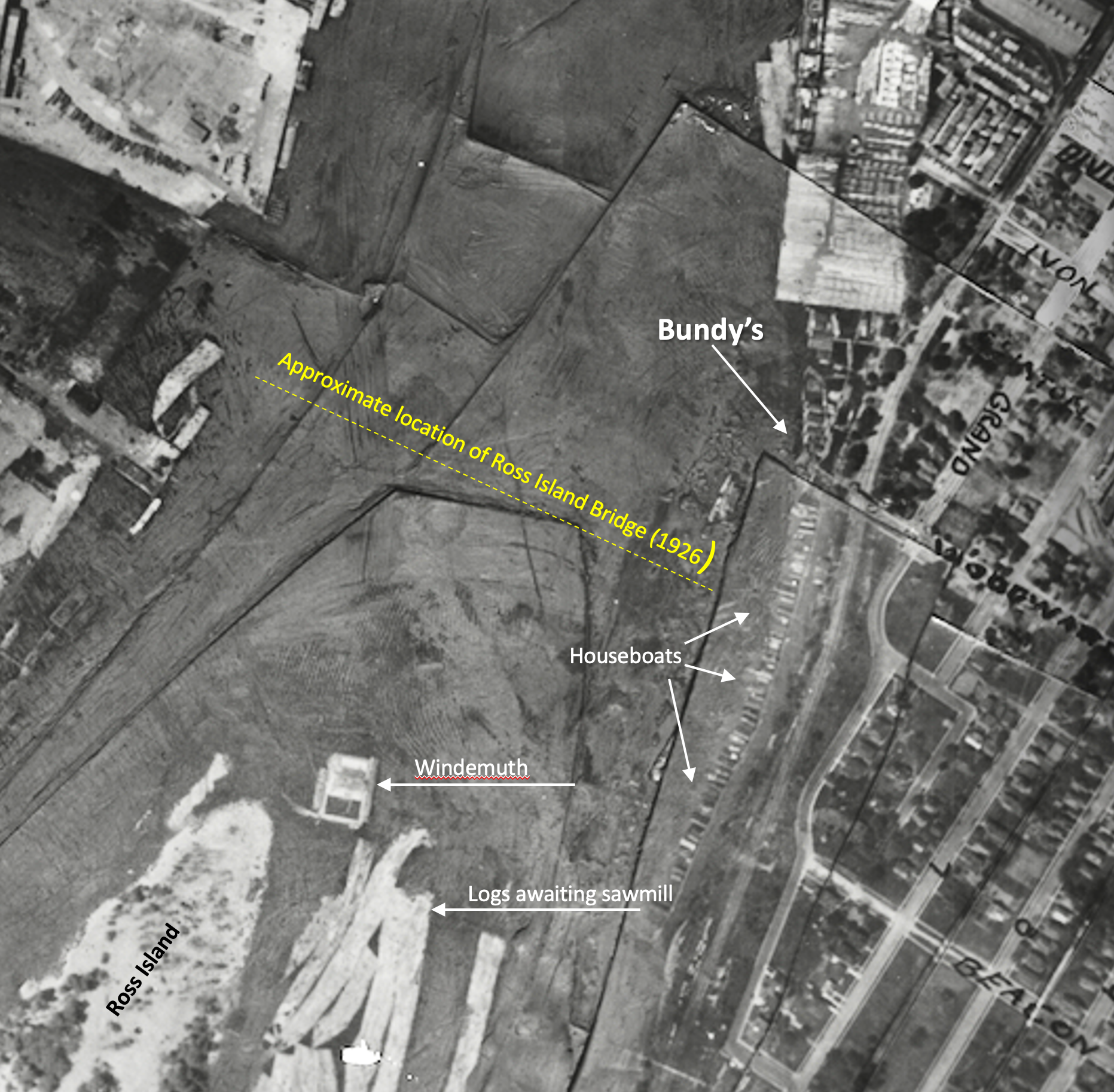
We actually catch a glimpse of the floating Windemuth in the center toward the bottom of this 1925 aerial photo, one year after its closure. There’s lots to look at here, so we’ve pointed out a few things including the houseboats that once lined the river in this location—a Bohemian community of artists, architects, writers and others; floating log rafts awaiting the saw at nearby mills; the location of the future Ross Island Bridge which would come along in 1926, and the floating rectangle that was Windemuth.
Detail of 1925 aerial photo with labels added. Click to enlarge.
Meanwhile, John A. Jennings was busily trying to find a way to salvage some aspect of the Willamette River swimming tradition and the market niche he had created with Windemuth, announcing bold plans to build a giant swimming tank on the north end of the island.
From The Oregonian, May 24, 1925
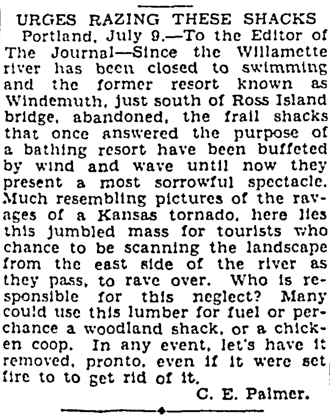
But Jennings’ vision was never fully realized: he died of a heart attack in April 1927. Some small related buildings existed on the island then, and the new bridge loomed overhead just downstream. The fate of the actual structure of floating Windemuth was never reported on.
The view from the new bridge down to the former much-loved site of lost Windemuth was a painful a reminder of what had been. This letter writer to the Oregon Journal was tired of looking at it and ready to move on to the next chapter:
We’ve been helping a long-time Northeast Portland family sort through their 100-year-old photo albums to identify some mystery locations and develop context about important family places. We love working with old photos (there’s a whole category here on the blog called Photo Detective dedicated to the topic which we think makes interesting reading and looking).
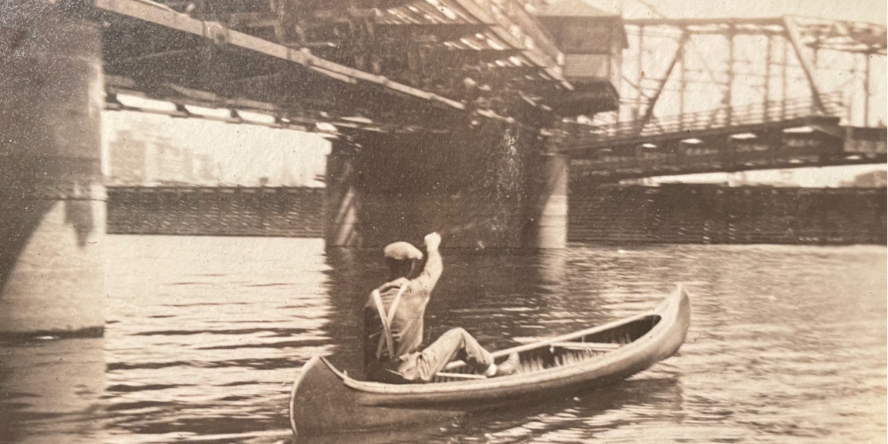
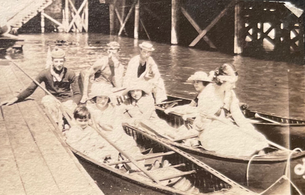
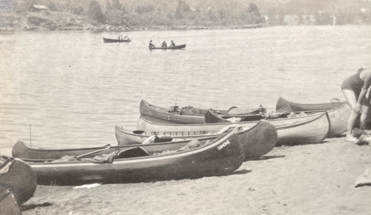
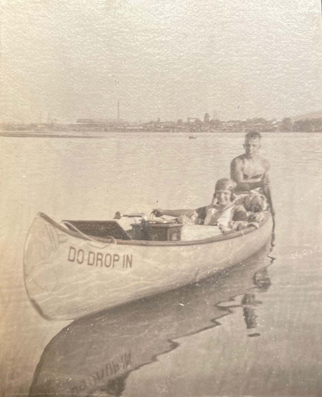
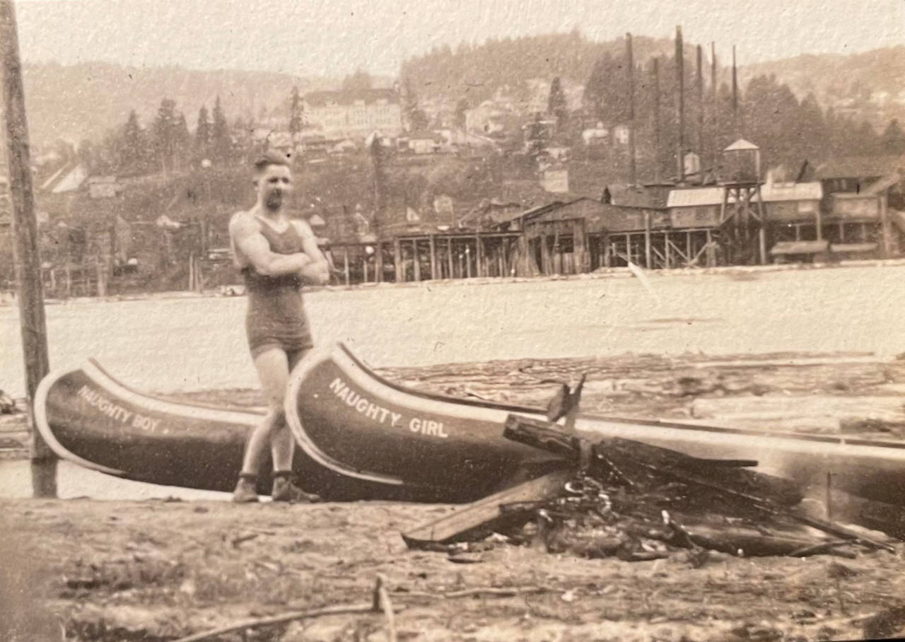
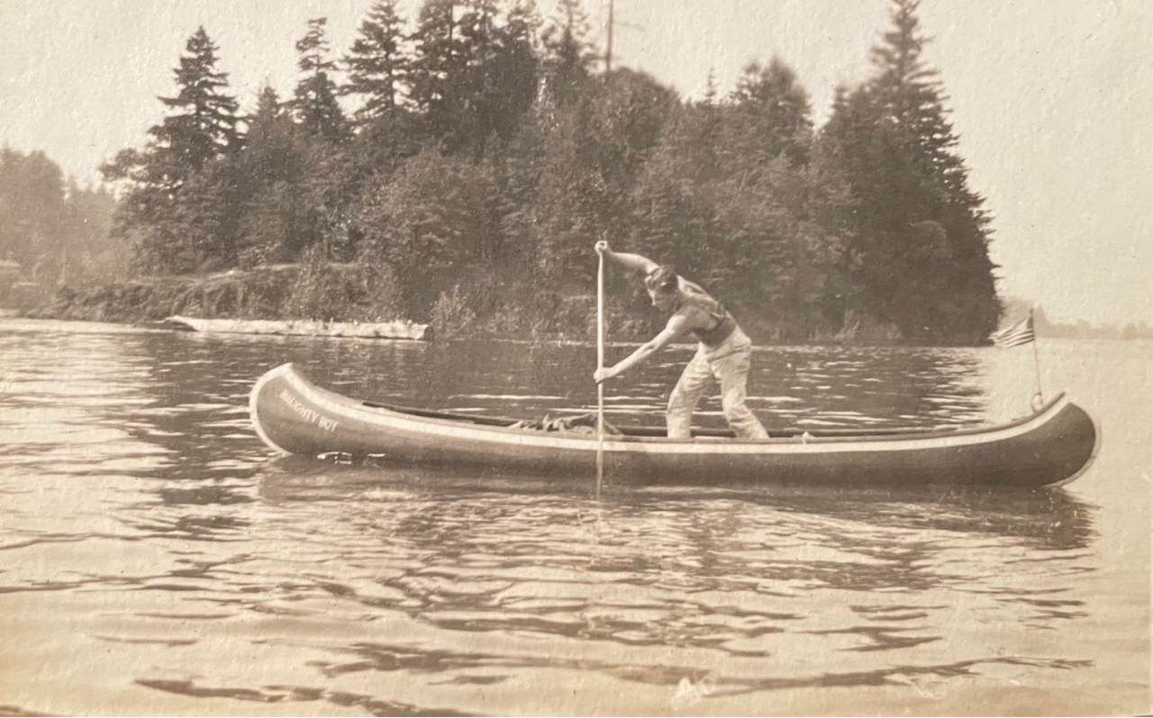
100 years ago, this family loved to play outside and one of their favorite places was the Willamette River between Swan Island and Oak Grove. Like so many young Portlanders of that era, their key to exploring these places was a canoe.
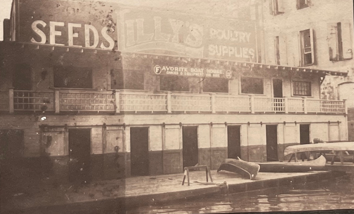
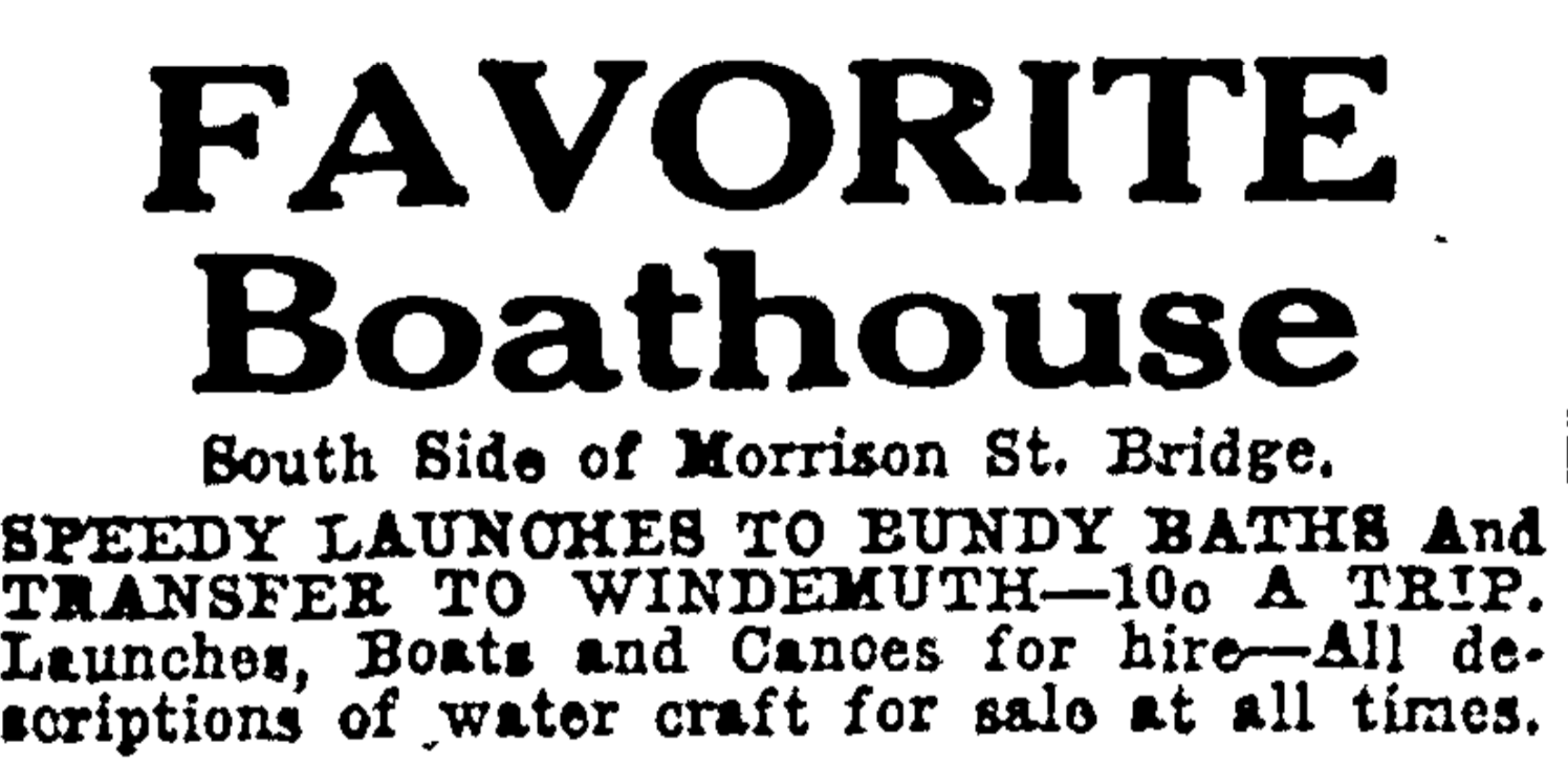
Departing from The Favorite Boathouse under the west end of the old Morrison Bridge, a swing bridge built in 1905 that was replaced in 1958 by the bridge we know today. In the photo above looking to the east, the eastern span of the old bridge is swung open to allow heavy river traffic to pass.
Along with front-porch moments of young families, babies and World War 1 soldiers returning home to Northeast Portland, the albums contain pages and pages of river adventures from the summer of 1919. Since we are frequently in the same waters by kayak and canoe, finding these glimpses struck close to home and got us wondering about the connection between Portlanders and the Willamette 100 years ago. These young people clearly were connected with their river, which looks to have connected them with each other in the special way that rivers do.
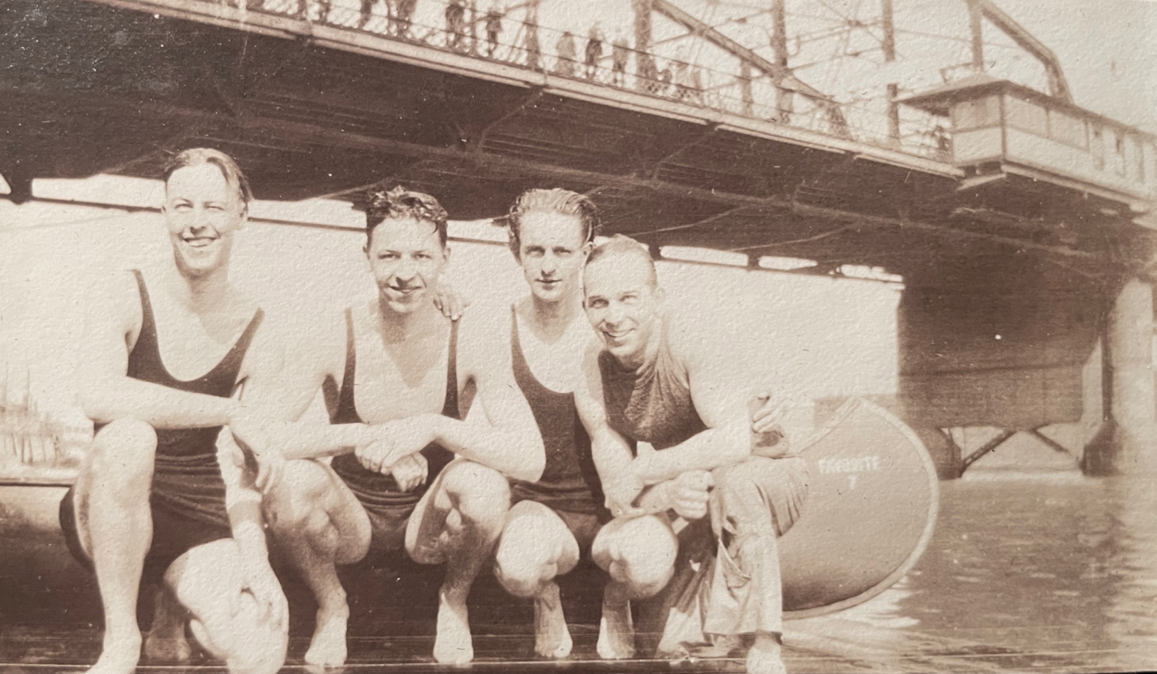
A boathouse on the west bank of the Willamette just south of the Morrison Bridge seemed to be at the heart of many adventures, a place appropriately called “The Favorite Boathouse.”
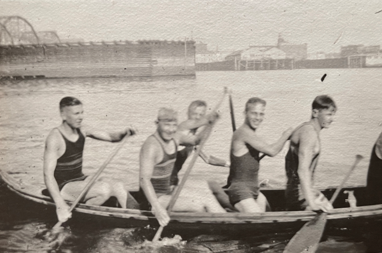
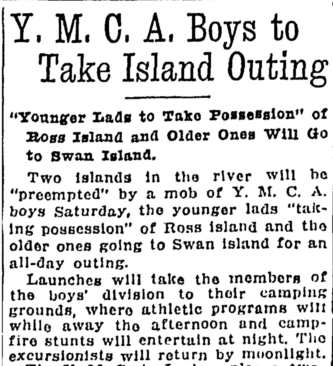
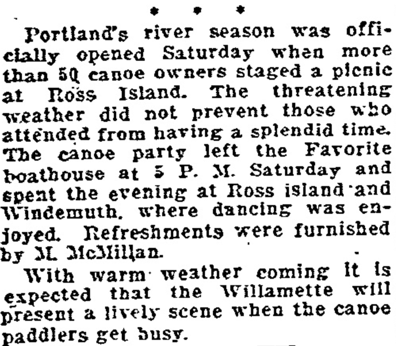
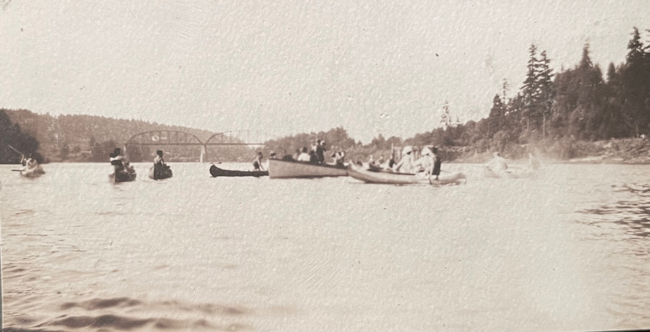
A look through the Oregon Journal and The Oregonian during these years opens a window into just how many young Portlanders took to local waters by canoe. At the time, Ross Island and Swan Island were outposts for recreation (and Swan Island was still very much an island). In 1916, both were destinations for organized outdoor recreation.
From the Oregon Journal, April 20, 1916.
From The Oregonian, April 25, 1921
A popular destination for Willamette paddlers in the late 19-teens and early 1920s was Windemuth, a giant floating swimming pool and dance pavilion anchored in the river off the northern tip of Ross Island. By day, Windemuth featured swimming competitions and all manner of water play. By night, hundreds of paddlers arrived to dance on the floating dance floor.
From the Oregon Journal, July 14, 1923
The Favorite and other boathouses rented canoes for couples and groups to paddle upstream to Windemuth for the summer evening dances. If you didn’t want to paddle, you could pay to ride a scheduled “motor launch” from downtown. Or from the eastside, you could take the Brooklyn Streetcar to the foot of Woodward Street and catch a short boat ride across to the floating pavilion.
Unfortunately (and not surprisingly) there were frequent swampings of canoes from the wakes of the many steamships active in Portland harbor, and regular drownings, often at night, coming and going to the islands.
From The Oregonian, May 14, 1923
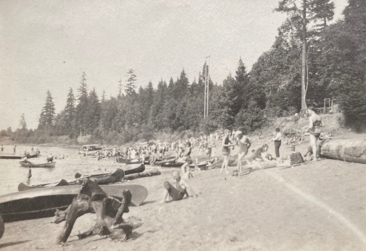
On Swan Island north of downtown, the beach in summer was filled with canoes that brought young Portlanders over the waters to sunbathe, picnic and camp.
Looking toward downtown from near the beach on Swan Island. Note the Victrola record player in the front of the canoe. The Victrola and its records, picnic boxes, bags of clothes and camping gear show up as payload in multiple photos. Summer 1919.
Handed down family stories describe young people swimming among and playing on the many rafts of logs that were tied up along the Willamette banks awaiting use by local sawmills. During these years, log rafts lined both shores from the Sellwood Bridge to St. Johns.
Taken on the western shore of Swan Island looking to Portland’s west side, with two canoes. The sawmill on the far side of the river is the Northern Pacific Lumber Company mill located in the vicinity of today’s Terminal 2 on NW Front Avenue. The very large building in the background is the old St. Vincent Hospital located on Northwest Westover. A log raft is visible anchored just off the near shore behind the canoes. Summer 1919.
Family members enjoyed paddling farther south, around the Milwaukie bend at Elk Rock Island and upstream under the Union Pacific Railroad Bridge at Lake Oswego to the vicinity of today’s River Villa Park, a nice six-mile paddle from the northern tip of Ross Island.
Elk Rock Island, Summer 1919
Looking north toward the Union Pacific Railroad Bridge at Lake Oswego (built in 1910), which is still in use and marks the northern edge of today’s River Villa Park in Oak Grove.
But by the mid 1920s, Portland’s recreational relationship with the river was about to take a major turn, due to health concerns resulting from the reality that the city’s raw sewage went straight into the river.
From the Oregon Journal, July 31, 1924
The shutdown relegated moonlight canoe trips to wistful memories a generation later. Below, from the Oregon Journal, May 5, 1946.