Recently, we had a chance to visit with Jennie Fennelle, a northeast Portland resident and old house dweller who also runs an interesting podcast called Echoes from the Attic.
Jennie wanted to talk about the discovery, intrigue and challenge of researching old houses and the notion that every house has a story (so many stories) which often lead to other stories, insights and questions.
We had a nice chat, which she turned into Episode 5, a 20-minute piece that covers a little bit about the why and the how of old house research. Might spark your imagination to start doing some digging of your own (here are some suggestions about getting started).
Our favorite from Jennie’s podcast line-up is her first, about the mystique and sentimentality of estate sales, but the whole premise of the show is worth a listen.
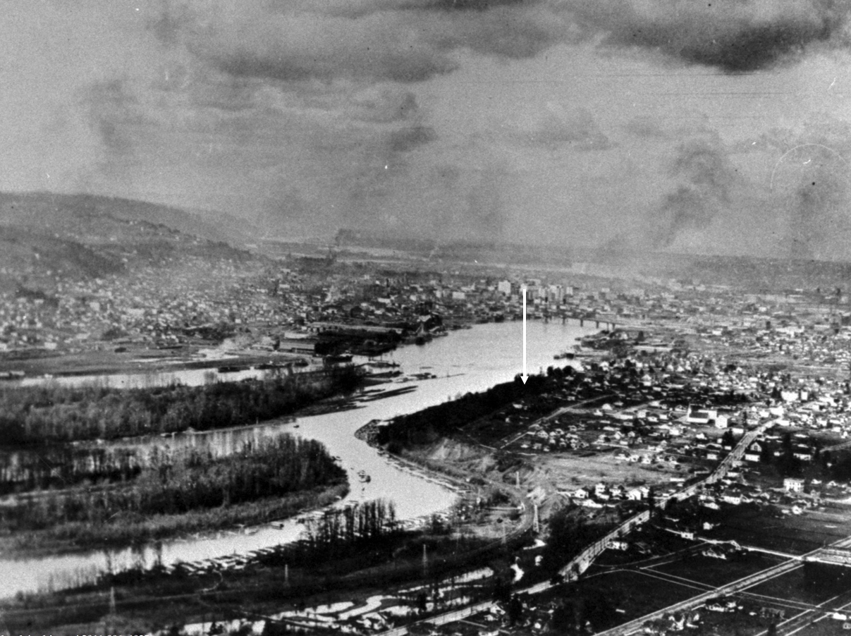
Looking north through southeast Portland and along the shoulder of Ross Island, about 1925. The arrow shows the approximate location of a house somewhere in the mist we wanted to know more about. Image courtesy Portland City Archives, A2011-006.
Sleuthing old photos to determine location, context and insights is a favorite thing to do; the Photo Detective category here on the blog is testament.
But sometimes, the biggest mystery is just finding the old photo.
Such was the case recently when a reader wrote seeking an assist in locating a photograph of a house fixed in childhood memory from the 1950s: his grandparents’ home on the bluff above Ross Island, torn down more than 50 years ago to make room for McLoughlin Boulevard. No known photos of the house had survived.
But in his memory, a version of the house was still there. Burnished over the years and important because it was a house that contained the full arc of life for people he cared about who were also gone. Maybe by having a photo of the house, he could call them to mind, and consider his own experience there as a small person.
When researching houses for clients, we’re always looking for old photos, but there is no single source or easy way to do this. In Portland, it’s worth following your address back through old copies of The Oregonian and the Oregon Journal to see if there is a photo from an advertisement or some random mention over the years. You’d be surprised, it does happen.
Another potential source is Portland City Archives, which has a deep collection of public works, traffic study, zoning study and “stub toe” photos that might include an incidental catch of a place or building of interest somewhere in the background. You can use the search tool called efiles to search by intersection or street.
The stub toe photos are an interesting subset, documenting sidewalk tripping hazards for liability reasons and occasionally catching a house of interest in the background.
The Oregon Historical Society Library has collections of neighborhood photos that are always worth looking through: you might find something you didn’t even know you were looking for.
There are aerial photos too, some of which are available through City Archives, and others through the University of Oregon Library’s Aerial Photography Collection. Dating back to 1925, these images are mostly low resolution and grainy, but good enough to help address larger-scale mysteries. Examining the same place from the air every 5-10 years back to 1925 is fascinating and always humbling to see all we’ve missed and don’t know about a place.
An advanced aerial photo function within the indispensable research tool Portland Maps allows a year-by-year look back to 2006 and then in some cases back to 1948. And of course there is Google Streetview.
But the best sources with the best pictures are always private collections, as in family photo albums and attic shoe boxes of photos, which are also the most challenging and rewarding to find. But that’s another blog post.
Long before construction of McLoughlin Boulevard, the remembered house on the bluff had a Grand Avenue address, and stood on the east side of the street at the corner of Haig. Back in 1912, Grand Avenue was never intended to be a major thoroughfare connecting downtown and the central eastside with outer southeast Portland. Think: quiet, meandering neighborhood street.
Early on in the search, we used aerial photos and Sanborn maps to understand how Grand Avenue has changed. It once followed a slow, looping route along the high bluff to take in the views of the Willamette River to the west, calling to mind the way in which SE Sellwood Boulevard edges high above Oaks Bottom today. In the river just downslope from the house was the north end of Ross Island, with views straight at Bundy’s Baths and Windemuth.
It wasn’t until the late 1930s and early 1940s that Grand Avenue was widened and McLoughlin Boulevard first opened. Given growth in all parts of southeast Portland and northern Clackamas County—and the rise of the automobile in everyday life—traffic volumes began to increase and congestion followed. The Oregon Highway Commission was under pressure to “fix” the problem. By the mid 1960s, traffic engineers with the State Highway Division knew that widening of McLoughlin to six lanes—which had become Pacific Highway East, Route 99E—would be necessary, dooming the former neighborhood street.
By then, the remembered family in the remembered house were gone and the sense of that former neighborhood as a quiet place to look out over the river below was quickly slipping from living memory.
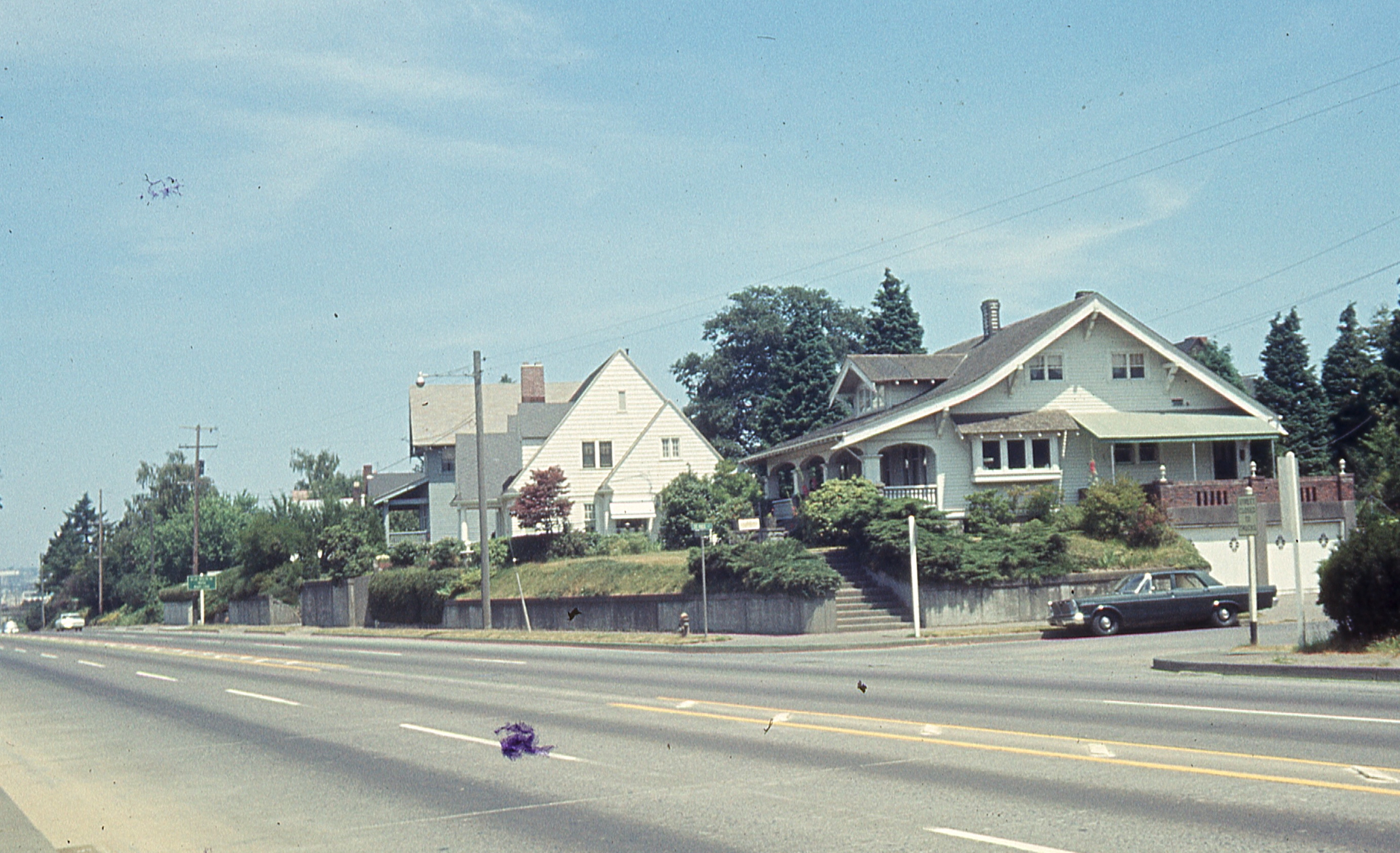
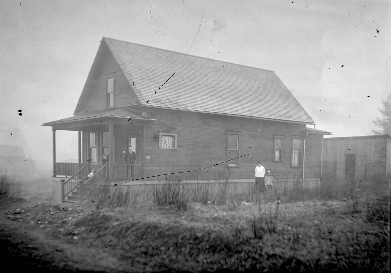
That’s when the studies began: land use studies, traffic flow studies, engineering studies. Surveyors out on the ground taking measurements, and–fortunately for us–taking pictures. And that’s where we were able to pull this house back to life from one sunny Wednesday afternoon in June 1965, through the lens of a traffic engineer. That’s it there on the right, the Craftsman bungalow, dormer facing west. Click in for a closer look.
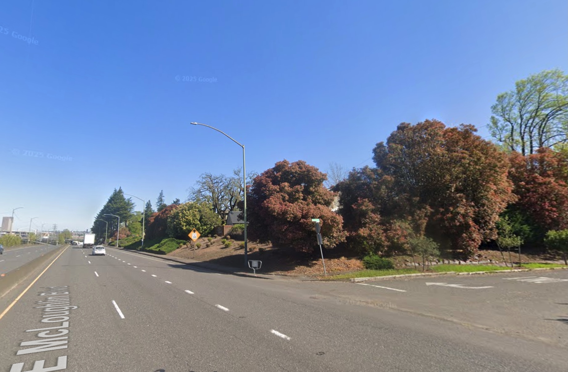
The former 670 Grand Avenue, a story-and-a-half bungalow built in the spring and summer of 1912 by Benjamin F. Doty, a well-known Portland homebuilding contractor and as it turned out father of the young newlywed who lived in this house for most of the rest of her life. This house and nine other adjacent homes from the old neighborhood were torn down in 1970 to make way for another lane of traffic on McLoughlin Boulevard. Below: the same view today (thanks to Google Streetview).
How does the photo compare with the memory? Maybe an unfair question since how does memory ever compare with anything, but we wanted to know. Certain things were familiar.
But just having the photo created a perch from which other memories and imaginings and questions could now rise. And for an old house researcher like us, it felt like finding the precious needle in the overwhelming haystack.
In our continuing quest to learn more about the people who designed and built Portland’s neighborhoods and homes, we’re adding nine more builder biographies bringing our total number of homebuilder and architect profiles to 41. You can find these profiles under The Builder’s tab here on the AH blog. Between them, these nine builders were responsible for hundreds of Portland homes.
In this latest batch, you’ll notice the continued theme: Portland’s housing stock from 1900-1950 was built primarily by immigrants, with Swedish immigrants figuring prominently. Here are some highlights:
Horace Askwith: Built in Laurelhurst and Alameda before taking on the job as Superintendent Architect for the Oregon-Washington Railway and Navigation Company.
Robert Beat:the Scottish designer and builder who built more than 100 houses in Irvington, where he lived. The gold standard of Portland homebuilding.
George Binkey: A hardscrabble builder who focused on the Elberta Addition in the early 1900s before moving to the Coos Bay area.
Oscar Earlson:Built houses on both sides of the river and found time to be a leader of Swedish culture in Portland.
Nils Eklund: Swedish immigrant who saved money with his wife Signe to build their first house, which ended up launching a prolific homebuilding career.
J.W. McFadden:Active builder in Laurelhurst and Alameda, was almost successful in building a commercial building in Coe Circle, and who eventually built a special memorial for Oregon’s most famous dog.
Conrad Mueller: German immigrant builder who bought tax foreclosed lots to stay busy during the Great Depression.
Fred Turner: Changed his name in 1918 to sound more American. Turner built many Northeast Portland homes and an historic apartment building before turning to development in the Burlingame area of southwest Portland.
Thomas Winship: Prolific English-born homebuilder who was the spark plug behind construction of the old Rose City Park Library (now demolished).
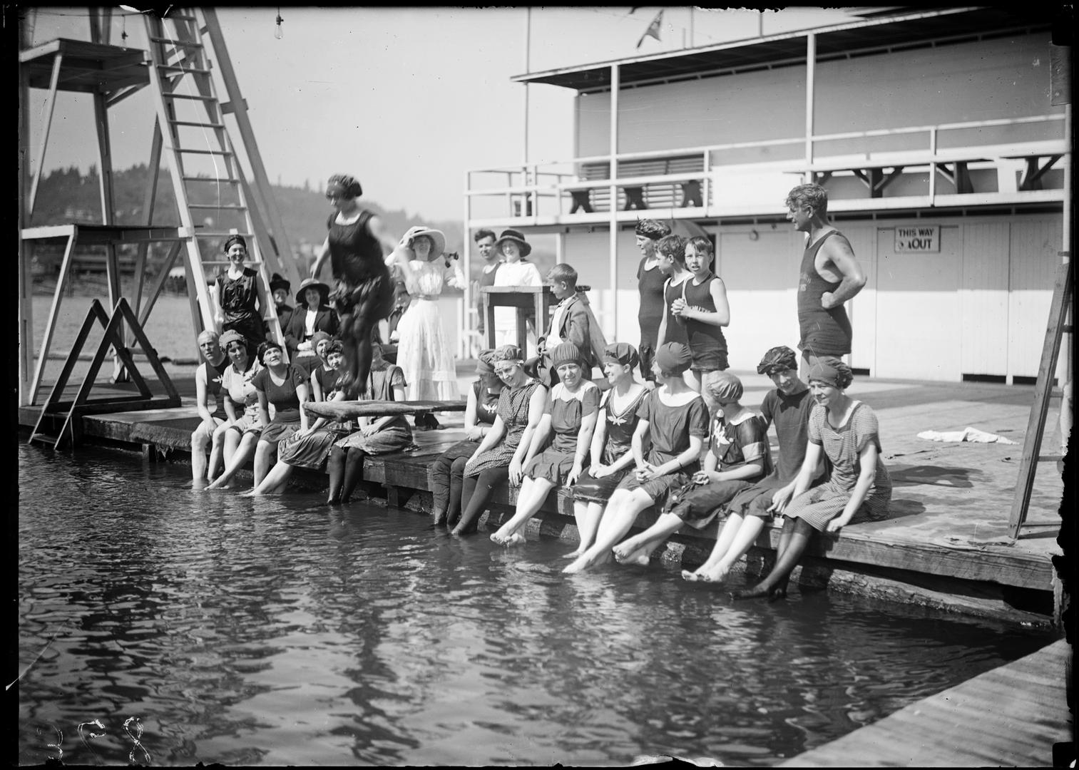
Swimmers at Windemuth. Angelus Studio photographs, 1880s-1940s, University of Oregon, Oregon Digital. PH037_b012_AG00052
News just in from the Oregon Encyclopedia that our entry on Portland’s once-great swimming platform afloat in the Willamette River known as Windemuth, and its on-shore predecessor Bundy’s Baths, has been published. Here’s a link, go take a look. If you haven’t seen the Oregon Encyclopedia before, better bookmark it. The OE is a great source of information on all things Oregon.
Prior to the mid-1920s, during days like the recent heat wave, this stretch of the Willamette River just downstream from Ross Island was a haven for Portlanders trying to stay cool and have fun. In July 1924, swimmers were ordered out of the river due to serious health and water quality conditions due to the accumulation of raw sewage routinely discharged into the river. An eerie parallel to the recent blue-green algae outbreak in the same area.
If you’re hungry to read more about Bundy’s and Windemuth, check out our past posts on the topics:
We’ve enjoyed re-exploring the Vernon neighborhood this week, preparing for and leading a walking tour to make visible the many invisible layers of history there. Which reminded us of stories we’ve shared here. If you are a newcomer to this blog and haven’t seen these stories, you have some layers of history to sort through.
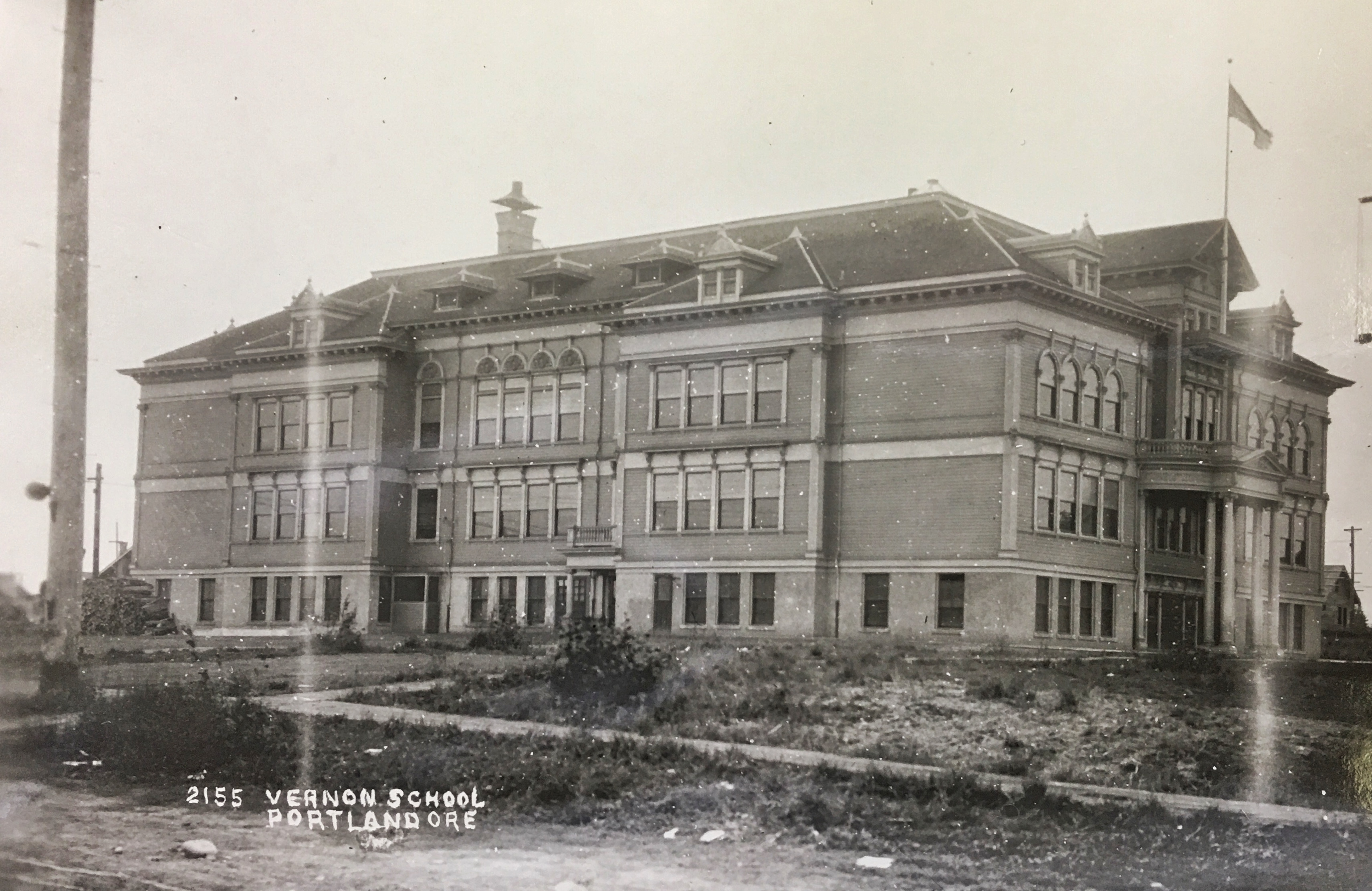
The original Vernon School occupied the entire block from Going to Wygant between NE 22nd and NE 23rd.This view of the school’s south side is looking north-northwest about 1912. The main entrance was on the north side in the center. Photo courtesy of the Oregon Historical Society.
The beautiful ghost of Old Vernon school, which took up the entire block between Wygant, Going, 22nd and 23rd. And the nearby Practice House which literally brought home economics home.
The amazing story of how the city pursued condemnation of property that is today’s Alberta Park.
The neighborhood outcry and organized protest effort in 1958 regarding construction of Fire Station 14 at NE 19th and Killingsworth. Today, we’re glad it’s there, but it wasn’t always that way.
The storefronts of Alberta Street and the tale of the 208 small businesses operating in 1930 between MLK and NE 33rd.
The beautiful little Mildred Hall at NE 23rd and Sumner (formerly the Norwegian Danish Congregational Church).
Every now and then in my research, I’ll find something—a memory, photograph, map or document—that really sticks with me and defines the way I think about a place.
This month I found a batch of mis-identified photographs when searching at City of Portland Archives that resulted in an absolute jackpot from 1913, opening a fresh window into the past near NE 33rd and Fremont.
Once known as Gravelly Hill, the area was indeed a gravel pit for many years in the late 1800s, and later the repository for all of the eastside’s household garbage between 1923-1924, then known as the Fremont Sanitary Landfill.
But before the landfill, back in 1910 as subdivisions crowded in around the big pit, questions were raised about the basic stability of Fremont Street, which was just below the brow of the Alameda ridge and ran right along the north edge of the pit. Developer Benjamin Lombard, who platted the adjacent Olmsted Park about that time, even sued the city for violating its own ordinance about gravel pits.
So, no secret: that slope South of Fremont was a gravel pit.
But as it turns out, it wasn’t just a gravel pit. It was a GIANT gravel pit. See for yourself:
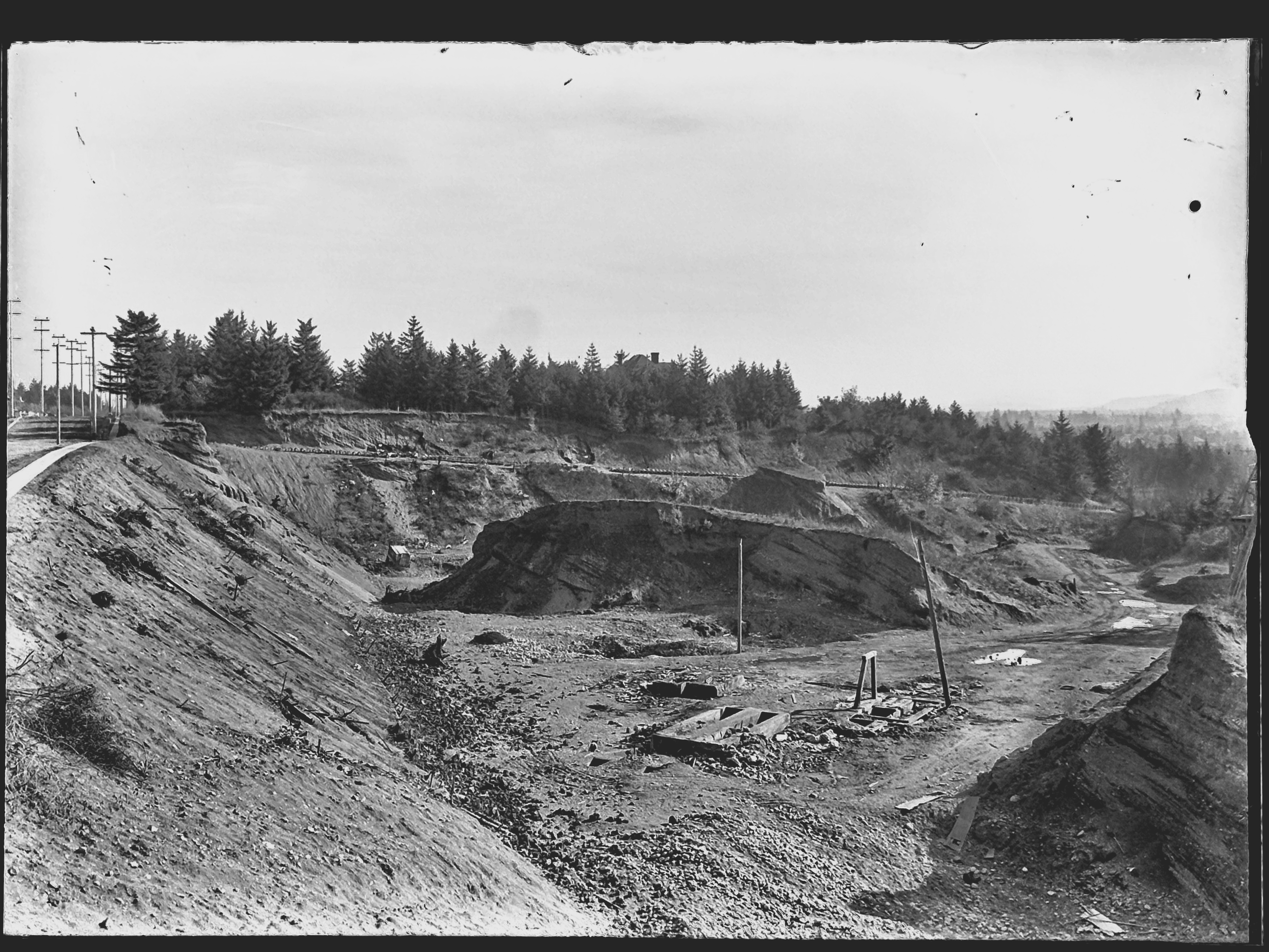
You’ll want to click into this for a good look. Looking east along Fremont toward NE 33rd from about today’s NE 32nd Avenue. Sewer pipe stacked along the eastern edge of NE 33rd, which slopes downhill left to right. The roof of the house visible at treeline in the center is the Barnes Mansion, 3533 NE Klickitat, which was then brand new. City Archives Photo: A2009.009-3611 (mislabeled as Lombard Street)
In 1913, a photographer for the Department of Public Works visited the pit and brought back 11 amazing images that got buried in the archives. They’re large-format glass plate negatives, not prints, and for years have been filed away in envelopes under “Lombard Street” at City Archives. I suspect few people have ever seen them. A few weeks back, something else I was looking for led me to these glass negatives.
I photographed each plate and made positive prints to be able to better visualize the scenes. And as I studied that first picture and figured out it wasn’t showing Lombard Street, but Fremont Street, I knew this would be a find to remember.
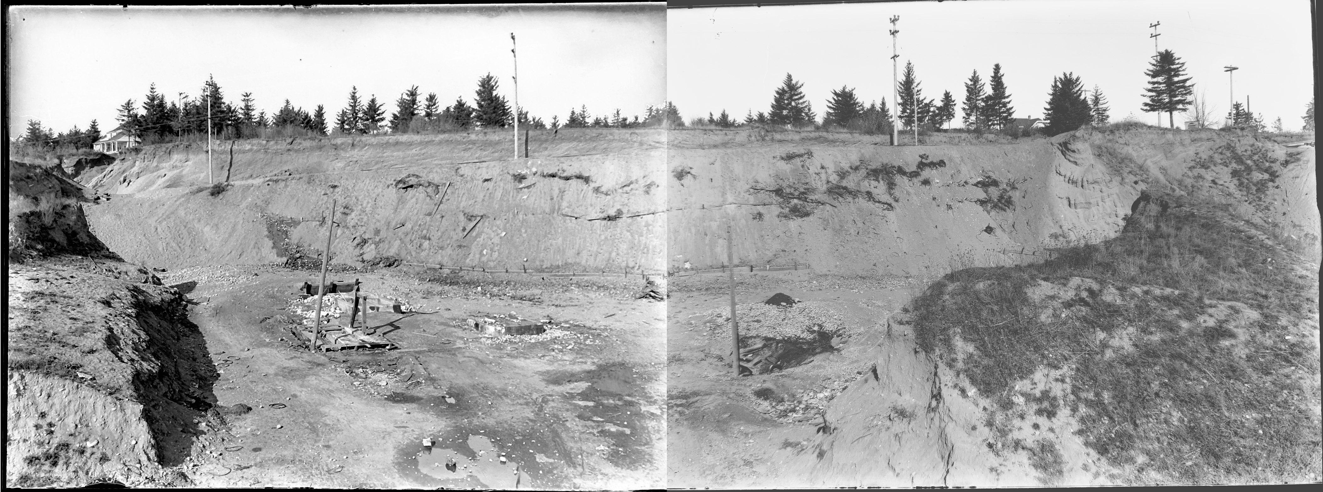
After that first photo, there were these next two, clearly taken as a pair, to illustrate the depth and breadth of the pit. Both are unquestionably tied to the Gravelly Hill landscape. Here I’ve melded them together to create a single image:
Looking north into the gravel pit at NE 33rd and Fremont, December 1913. Click to enlarge. View would be from between today’s Siskiyou and Klickitat streets, looking uphill. The house at far left is today’s 3251 NE Alameda Terrace. The house at far right is the top of today’s 3305 NE Alameda. A sign is visible at upper right for a new subdivision, placed in the cutbank on the northeast corner of 33rd and Fremont. Segments of sewer pipe are visible stacked there. Today, the pit is filled with three city blocks and more than 50 homes. City archives photos, left: A2009.009.3619; right: A2009.009.3620.
Here’s a bit more context from neighborhood historian R.A. Paulson, writing in The Community Press on October 1, 1975:
“From the earliest recollections of those familiar with the area, this was a worked out gravel pit, the excavation of which had been finished many years before but still showing the signs of one-time activity. As late as 1919 and 1920, the pit formed a precipice going down sharply from near Fremont possibly 100 feet or so to the level of Klickitat and extending between 32nd place and 33rd Ave. Coming from the west, Kllickitat Street was unpaved east of about 29th with the cement sidewalks ending there but even between 26th and 29th these sidewalks were impassable because of the overgrown bushes and small trees.
“The gravel pit had been a lush source of rock and gravel for someone way back and the solid bank of this material had originally sloped down from Fremont at the same grade as the present 33rd Ave. This had been scooped out over a period of perhaps 50 years or more and most likely went into improving the lanes, roadways and public highways for miles around, certainly for the country roads that became 33rd Ave. and Fremont Street.
“The bed of the pit showed evidence that work and even habitation had gone on there but at the time of World War 1, only a monolith of stone, too difficult to remove with pick and shovel, reared upward from the new level.”
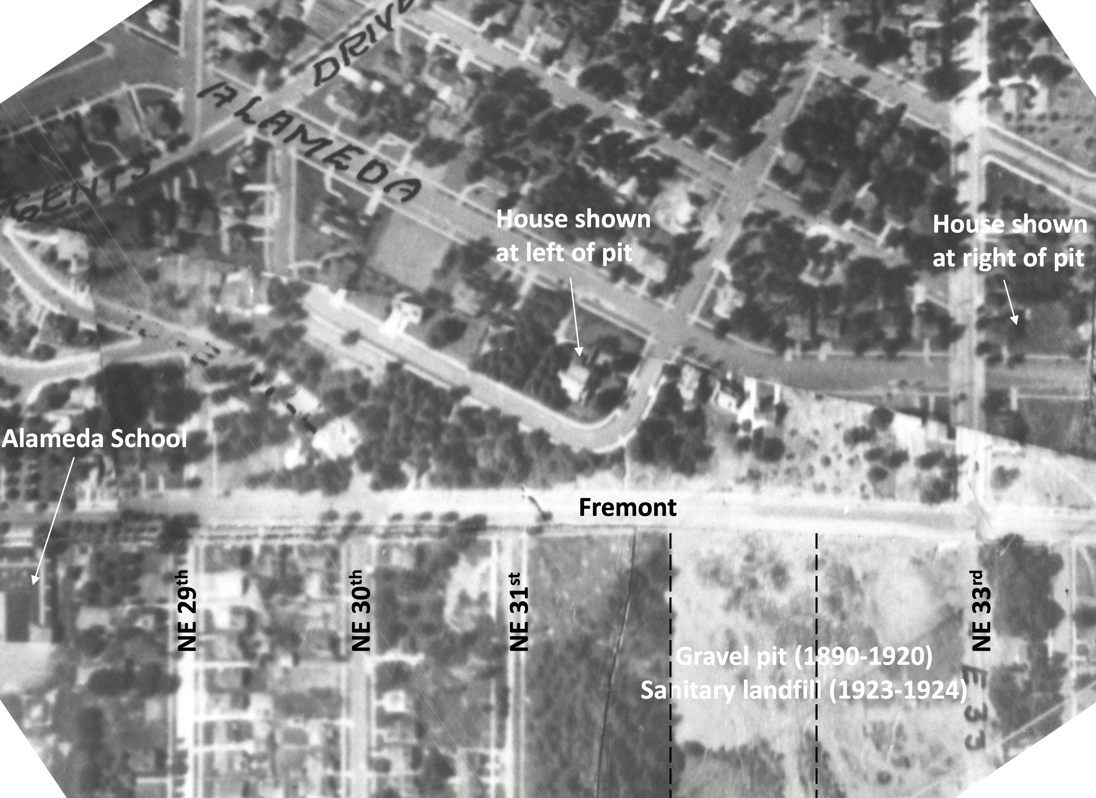
Here’s a detail from a 1925 aerial photo that shows the extent of the pit and the still-forming street infrastructure. The pit covered two-plus blocks, from NE 33rd to NE 31st, between Fremont and Klickitat.
Detail from a 1925 aerial photo showing the intersection of Fremont and 33rd, labels added for reference. Dashed lines indicate eventual location of NE 32nd Place and NE 32nd Avenue. Click to enlarge. Aerial photo courtesy of City of Portland Archives.
Stay tuned for eight other gems in this collection that are just as knock-your-socks-off amazing as these three. Next up: we’ll take a close look at the intersection of NE 33rd and Fremont 111 years ago, absolutely recognizable to today’s eye.
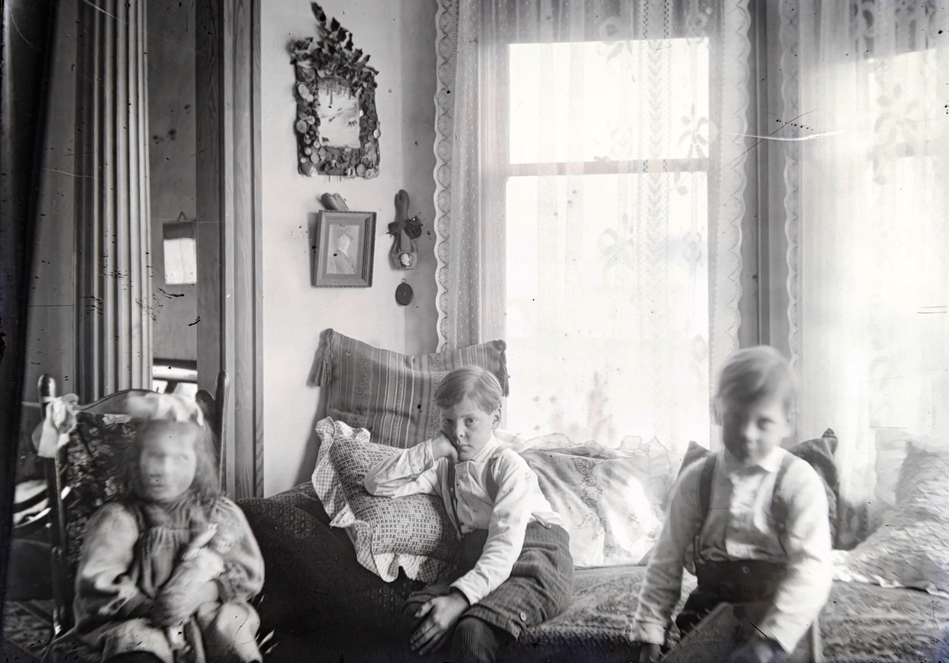
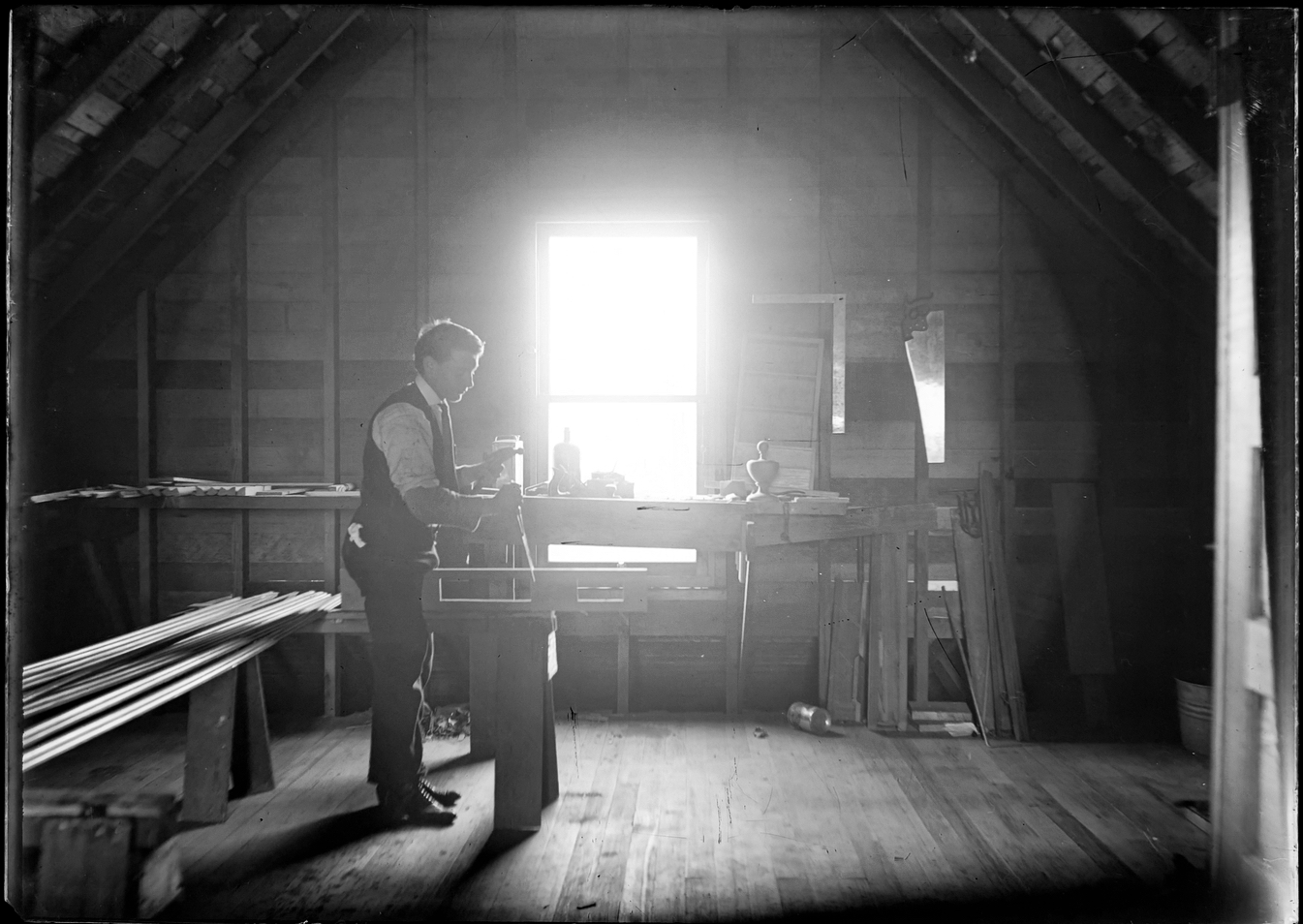
Six glass plate negatives from 1908 retrieved from the basement of the von Homeyer house in Northeast Portland tell a story about a setting, home and family life that have become extinct but not forgotten.
The first von Homeyer house in northeast Portland at 850 Going Street (today’s NE 27th and Going), from a glass plate negative. Hans O.S. von Homeyer on the roof with sons Hans W.S., and Irvin Erwin Frederick. At the back steps: Minnie and daughter Gretchen. View looking toward the northwest, about 1908.
The glass plates are some of the thousands of photos unearthed by new owners Michael and Jaylen Schmitt earlier this year as they prepared the house for overhaul and adaptive reuse. This winter and spring, we helped the Schmitts sort, organize and add context to the mountain of photos and documents that had accumulated in the house over the last century.
In May after careful review of each image, we sent more than 30 pounds of old photos “home” to the next generation of family members who had never seen many of these long-passed great aunts, uncles, grandparents and family scenes. Duplicates and some others (including the glass plates) went to an estate sale that helped clear out the house in May. A select few of the photos and documents will remain behind with the house going forward.
But these six are special, because they are so old and fragile, and because after some detective work, we now know what they depict.
The first time we saw them this winter, we knew they might be some of the most interesting images in the entire collection: they showed a young family’s connection with an old house–something always near to our hearts.
The von Homeyers at 850 Going: Erwin and Hans at left; Hans, Minnie and Gretchen on the front porch. Looking southwest about 1908.
They showed wide open spaces around the house, hinting at things to come.
The von Homeyers at 850 Going: Hans, Hans and Erwin on the porch; Minnie and Gretchen at the side. No sidewalks, dirt streets and wide open lots all around. Looking east-southeast about 1908.
They showed the home’s interior, three children in the foreground, columns and windows behind.
Gretchen, Hans and Erwin at the bay window, 850 Going Street, about 1908.
And they showed a builder at work upstairs. The backlighting from the second floor window makes it difficult to see, but the carpenter’s square, saw and plane behind him, hammer in hand, and the at-work stance of the human subject, come through clearly.
Hans von Homeyer at work, upstairs at 850 Going, about 1908.
As glass plate negatives go, they are a tad hard to read if you just pick them up for a quick look. Thick with emulsion, it takes a lot of light to reveal the negative image. Which might be one of the reasons why they survived the estate sale: people couldn’t tell what they were seeing.
We made prints and stared at them for a long time. Where is this place, we wondered.
Over the winter, as we continued looking at hundreds of family photos and began to recognize particular people and places, and as we researched the von Homeyer family story, a common thread began to tie some pieces together: this house.
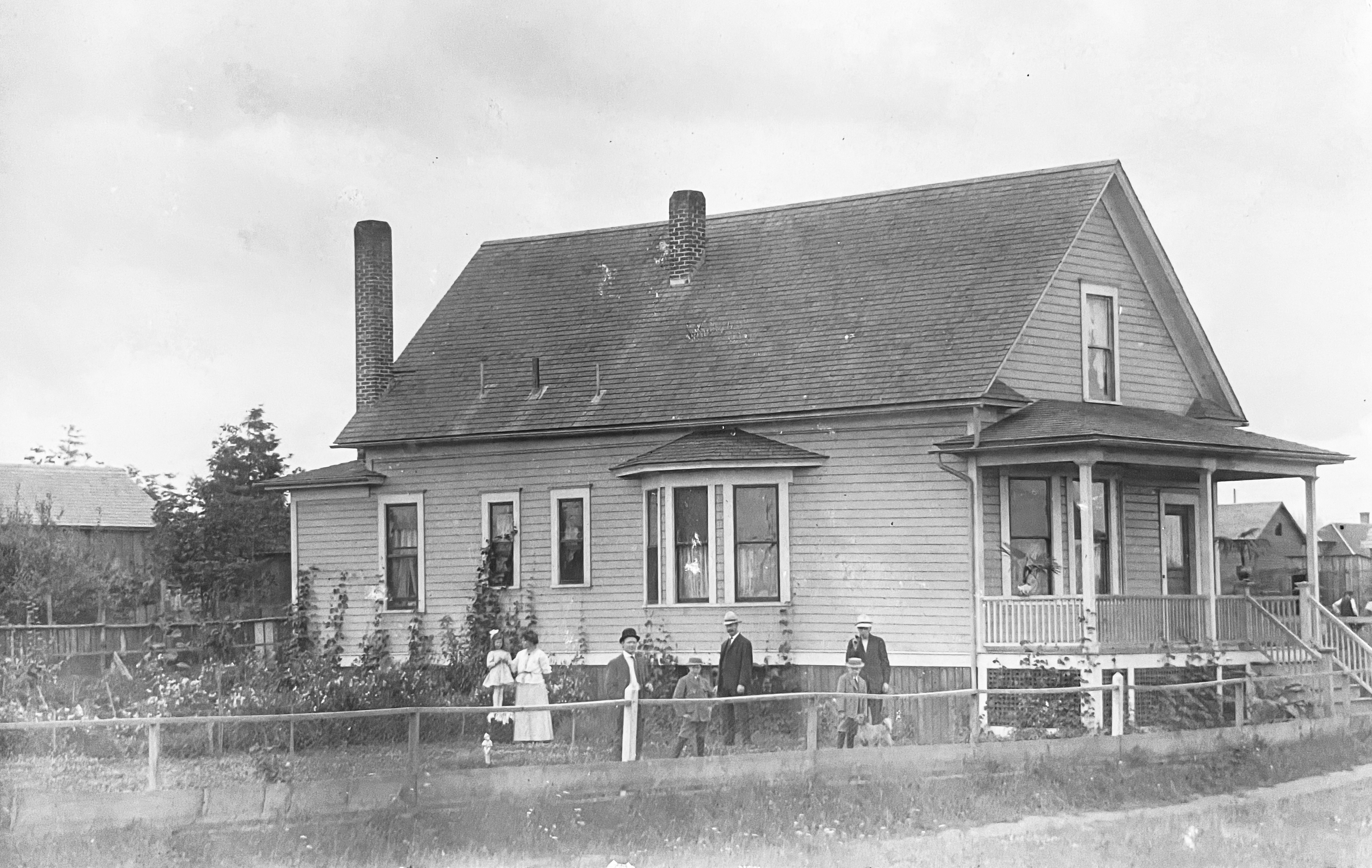
First, we found this paper image in one of the old photo albums. It’s a “Real Photo” postcard showing two generations of a family out front of a tidy house.
This Real Photo postcard was sent from Hans to brother-in-law Karl Tripp about 1909, looking southwest. Minnie and Gretchen at left; Hans center with Hans and Erwin; two unknown visitors. A few more nearby houses and a new coat of paint.
The glass negatives show a slightly earlier version of the house, before paint, less landscaped, a little rough around the edges, but definitely the same place. By 1909 and the postcard to Karl, the von Homeyer home at 850 Going was looking pretty tidy.
Do-it-yourself cards like this were first offered by Kodak in 1903 and almost immediately blew up in popularity as friends and families exchanged their own photos and brief greetings through the postal mail. An early and s l o w version of sharing photos and a few well chosen words across distance. Something families still like to do today. Here’s more about how Real Photo postcards transformed photography between 1905-1915.
This one was sent by the first Hans O.S. von Homeyer (1871-1942), father of Hans W.S. von Homeyer (1898-1969) who built the house at NE 24th and Mason, grandfather of the brothers Karl and Hans E. von Homeyer (1927-2002) who lived in the Mason Street house all their lives. Hans the elder sent the card to his brother-in-law Karl in Chicago, Minnie’s brother. The message on the back was in German which we can’t read, so we sent a picture of the almost undecipherable longhand script to our friends Christiane and Roland in Germany for quick translation. They wrote back immediately with the 110-plus year-old postcard greeting that made us smile:
“Dear Karl, we are all still alive and frisky. How are you? With best greetings from all of us to all of you.”
The card was signed “H. von Homeyer, 850 Going Street, Portland, Ore.” which of course also piqued our interest, knowing that Going Street makes its long east-west transit through today’s King, Vernon, Concordia and Cully neighborhoods. We’ve looked at enough old east-west addresses to know 850 was going to be about 27 blocks east of Martin Luther King Jr. Boulevard and would probably end up in the Elberta Addition.
If you search for that address in pastportland.com (which is one of the very best tools for converting between pre-address change addresses and today) it comes up empty. Plenty of numbers either side, but no 850.
We looked for 850 in the 1909 Sanborn Maps, but this block and several others nearby were still unbuilt brushy vacant lots with dirt roads scratched into the ground. Sanborns were used by fire insurance underwriters to gauge fire risk based on the presence of fire hydrants, distance from fire stations and types of construction materials and heating systems used by various buildings. But out near 27th and Going in 1909, there weren’t any buildings that needed insurance underwriting. So, it wasn’t mapped.
Next we began nosing around The Oregonian and the Oregon Journal, both of which are searchable by word going way back if you have a library card. News stories, letters to the editor from Hans and other mentions began turning up, confirming the von Homeyer’s presence there.
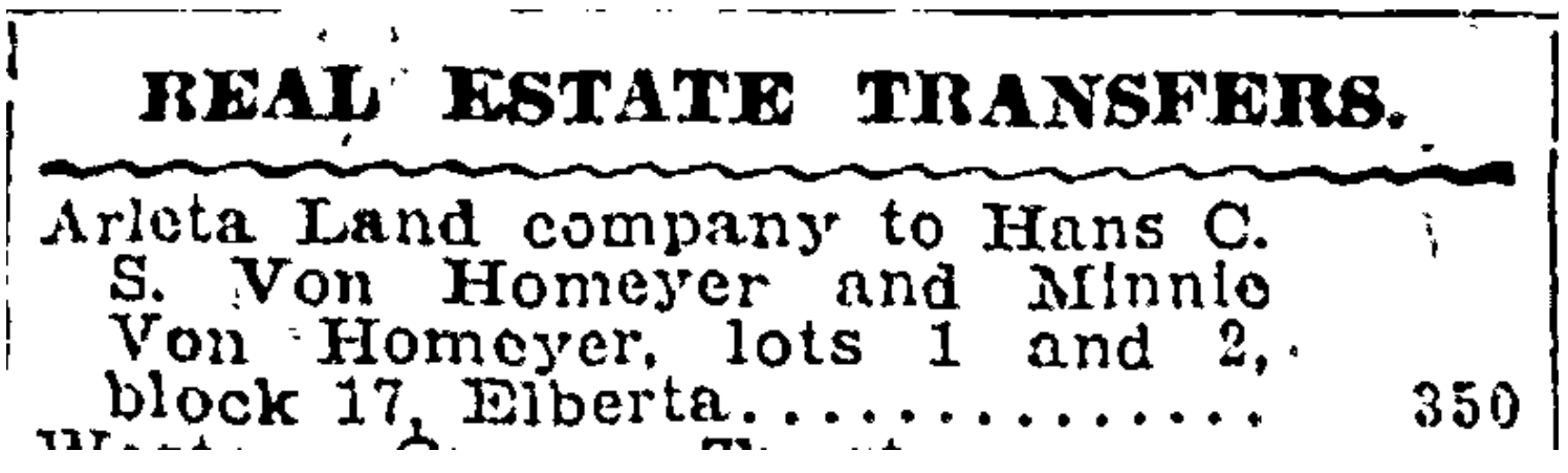
Then we found this buried in the real estate transaction list: Hans and Minnie buying a vacant lot in the Elberta Addition for $350 in late July 1907.
From The Oregonian, July 29, 1907
That gave us a lot and block number and a place to look. So we downloaded the Elberta plat from the Multnomah County Surveyor’s office, and began trial-and-error looking on Portlandmaps.com for block and lot details in that vicinity. We quickly found lots 1 & 2 of Block 17 today–the northeast corner of 27th and Going–but the pre-address-change address for that place says 848 and what’s there today doesn’t look anything like the postcard.
We began to note that after 1910, all references to 850 Going stop. Going, going gone. So how come 850 shows up in some news stories and on the postcard, but then disappears? We had a hunch.
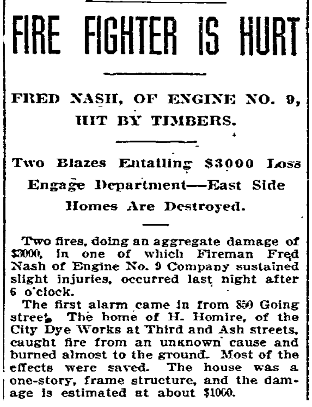
The next newspaper story we found made it clear:
From The Oregonian, September 20, 1909. Creative spelling.
Glancing back and forth between the post card picture and the glass plates, with the fire story in mind, the realization struck: the images on the old glass and the postcard print were showing the same house: the first von Homeyer home, built in 1907 after they arrived in Portland from Chicago. In September 1909, it burned to the ground.
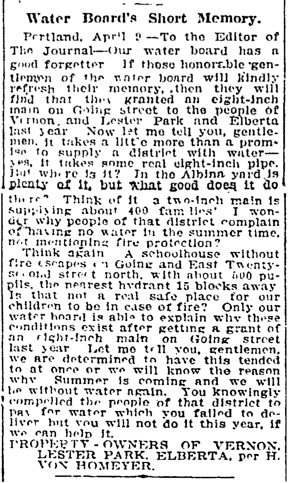
Eerily, Hans von Homeyer foreshadowed what might happen to their new home on Going Street. In a letter to the editor of the Oregon Journal the year before, signed on behalf of area residents, Hans gave voice to frustrations with the city about lack of water pressure in their part of the neighborhood, and worries about the fire safety of the huge wood-frame Vernon School just up the street, where their children attended.
From the Oregon Journal, April 13, 1908
In June 1911, Hans and Minnie sold Going Street and took up residence in a spacious Craftsman-style house on NE San Rafael just east of today’s Martin Luther King Jr. Boulevard. The kids were growing and so was their business. Later, the von Homeyers moved to Vancouver where their story continued.
Have a good look at the 1908 surroundings as you think about the corner of NE 27th and Going today. Just across the street is the former dry goods store. The streets were unpaved gravel, no curbs or sidewalks until 1913. On the property where the von Homeyer house stood, a new home was built: the late Queen Anne Victorian that stands today, known as the Going Queen. Today, that intersection is all concrete streets and sidewalks, topography leveled off, no vacant lots in sight.
Aside from the small miracle of their basic survival all these years is the reality these glass plate negatives somehow made it through the fire or were carried out of the burning house they depict: the news story reported “most of the effects were saved.”
For extra credit, the six glass plates also made it through the estate sale in May. No one was interested in them, so after the sale they made it to the dregs pile that Michael was going to have to deal with one way or another. When we learned this, we very happily rescued them from the dregs. Now they’re in a safe place.
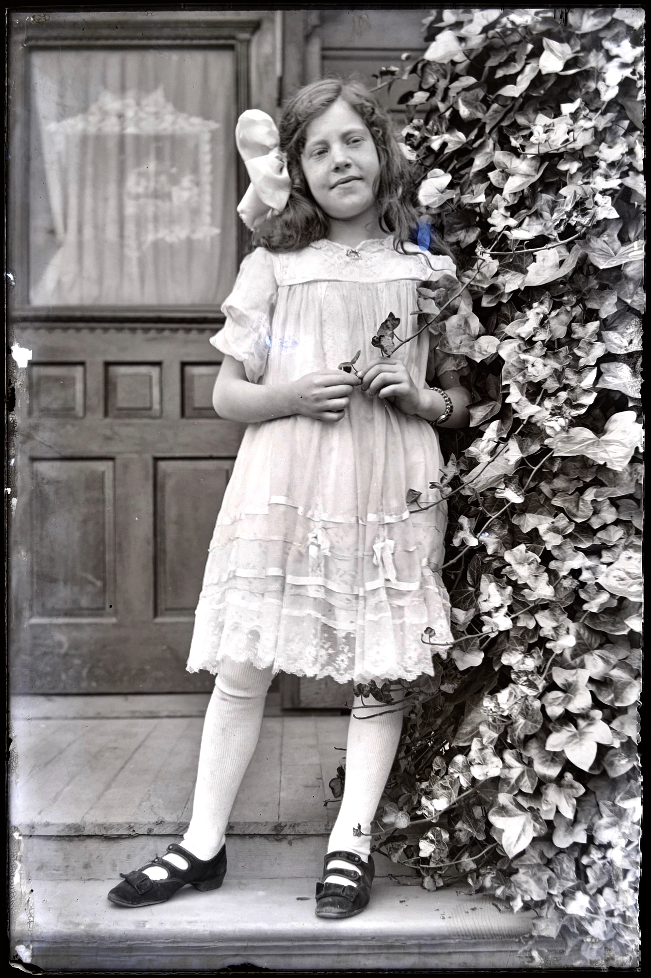
The last of the six glass plates–smaller in size, made a little bit later in a different location–may be the most wonderful, showing youngest sister Marguerita Anna “Gretchen” von Homeyer on a porch, bow in her hair, standing near an ivy-covered column, looking off toward the future. Probably taken in about 1913. She was eight years old.
Marguerita Anna “Gretchen” von Homeyer about 1913.
It’s been over a year since we’ve written about Willamette River swimming at Windemuth and at Bundy’s Baths on the eastbank in the vicinity of Ross Island. There’s an important anniversary coming up for Windemuth, plus we’ve learned a few more things (and found some more photos), so it’s time to say a bit more.
If you don’t yet know about Windemuth and Bundy’s Baths, be sure to follow those links and while you’re doing that, check out this great set of old photos and memories about canoeing the Willamette downtown during the summer of 1919. We’ve been haunting these places and the archives this summer to learn more about the hold they had on Portland’s soul, which was something.
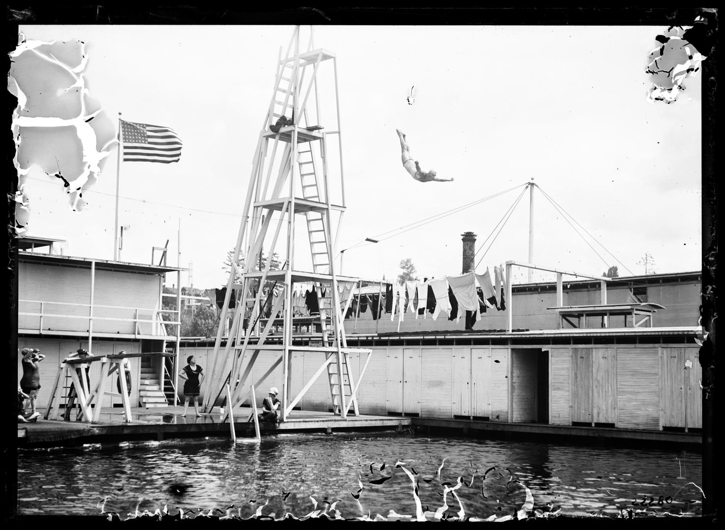
Briefly: Windemuth was a huge two-story floating swimming tank, diving venue and dance floor anchored off the north end of Ross Island (before the bridge, which was built in 1926) that held more than 500 people. It was so popular in the 19-teens and 1920s there were times it rode low in the water, packed with so many people.
Swimmers at Windemuth. Angelus Studio photographs, 1880s-1940s, University of Oregon, Oregon Digital. PH037_b012_AG00052
Earlier–dating back into the 1890s–Bundy’s Baths was the place to meet your friends, rent your swimming togs, and play in the water at river’s edge.
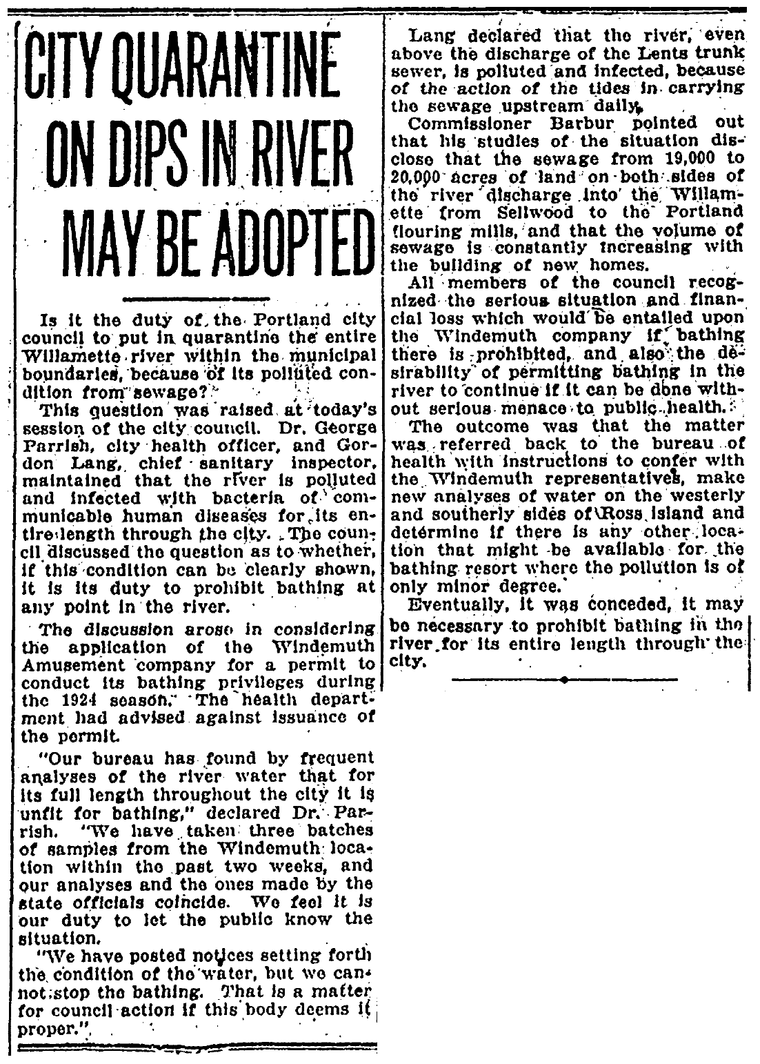
To the infamous anniversary: 100 years ago this month, Willamette River water was so polluted with sewage and human waste that City Health Officer George Parrish recommended Portland City Council pass an ordinance banning all Willamette River swimming in Portland. At the time (and up until 1952) all of the city’s raw sewage poured directly into the Willamette from nine major sewer outfalls. By 1924 it was a serious human health problem, as well as a wider environmental menace.
The topic came before council in mid-July 1924 because Windemuth was required to be relicensed in order to open to the public, a process that involved gaining an endorsement from the City Health Officer. The giant floating swimming platform had already opened that June to much fanfare, with relicensing just a bureaucratic box to check.
The place had become an institution: when Portlanders thought about being in the water (which in those days they did frequently) their first thought was the Willamette and Windemuth. It was the premier swimming venue in the city, the place for diving competitions, as well as being a top-flight social scene (think dancing at night to a live orchestra on a floating dance floor in the middle of the river).
Diving at Windemuth. Angelus Studio Photographs, 1880s-1940s, University of Oregon, Oregon Digital. PH037_P362
City Health Officer Parrish and Chief Sanitary Inspector Gordon Lang brought their findings into council on the day of the relicensing hearing: record-breaking levels of fecal coliform bacteria and low levels of dissolved oxygen. Beyond just not endorsing Windemuth, Parrish recommended council craft an ordinance prohibiting all river swimming.
Of course, banning swimming in the Willamette in Portland would mean the end of Windemuth, and as The Oregonian reported “None of the members of the council felt inclined to rob the Windemuth company of its business…” So council punted, ordering Parrish and Lang to take another set of samples to verify the earlier readings.
Nine days later, the relicensing question was back before council, with Parrish and Lang reporting levels hadn’t gotten any better. Between a rock and hard place now, council deferred action on relicensing Windemuth and directed Parrish and Lang to confer with Windemuth owner John Jennings to see what could be worked out regarding finding an alternative location. Council also raised the existential question of whether or not it even had the authority or the duty to ban swimming.
From the Oregon Journal, July 24, 1924
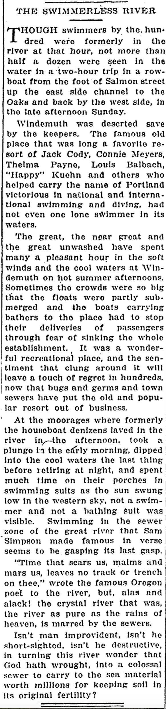
But Jennings saw the writing on the wall. People had lost confidence in the river. Record-breaking levels of bacteria in the Willamette were in the news every day. Parents told their kids not to swim in the river. And as water levels dropped in late July and temperatures rose, the Willamette didn’t look or smell very enticing.
On Sunday, July 27, 1924, Jennings announced he was voluntarily closing Windemuth. It was the end of an era. Portlanders got out of the river in the summer of 1924, mourned the loss, and stayed out until not so long ago.
From the Oregon Journal, August 5, 1924
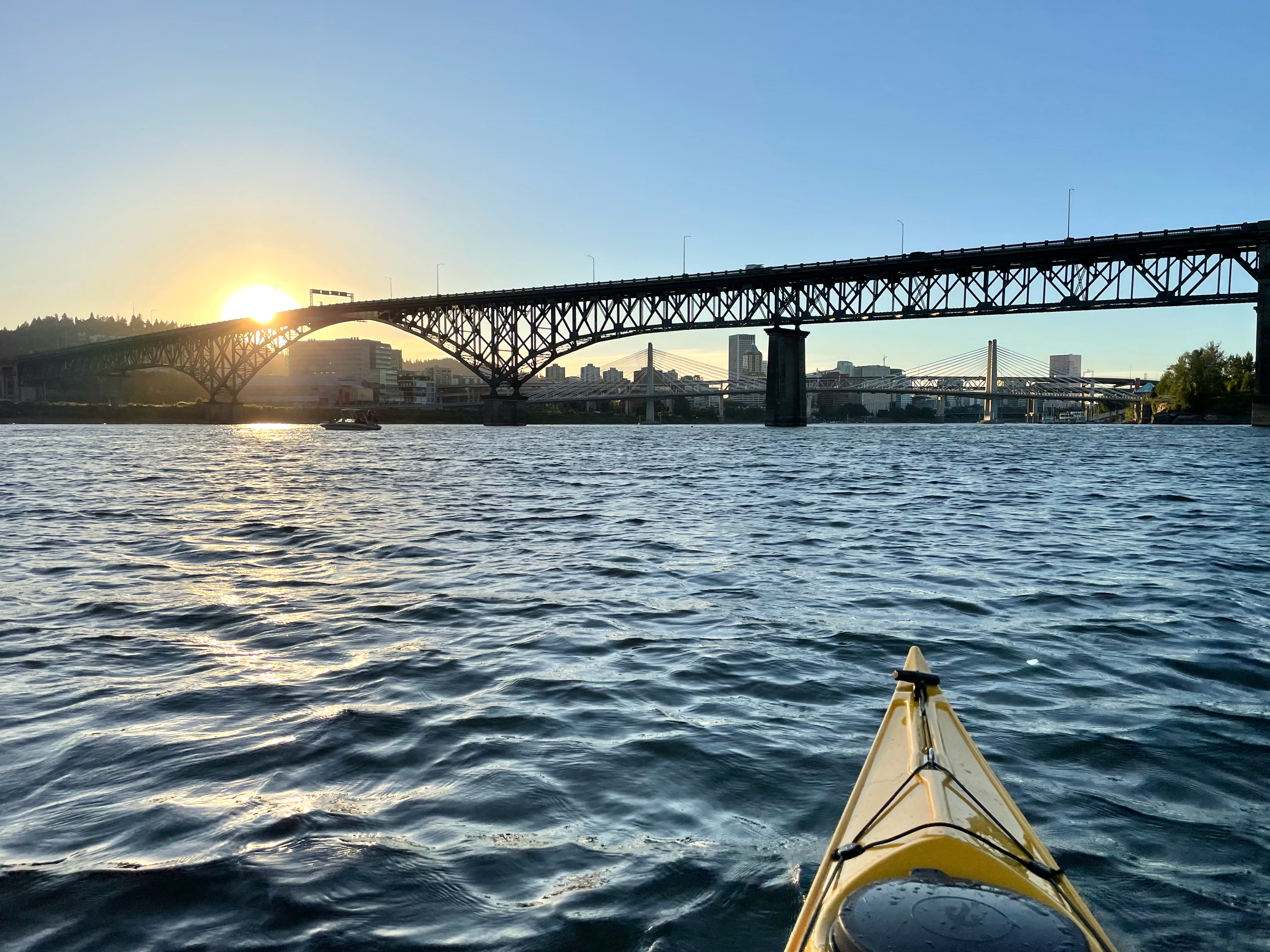
100 years later, a resurgence of interest in Willamette River swimming and much healthier and desirable conditions now beckon Portlanders back into the water, reminding us about what was lost, what has been gained back, and how we must never again take our river for granted.
Willamette River sunset near the former location of Windemuth.
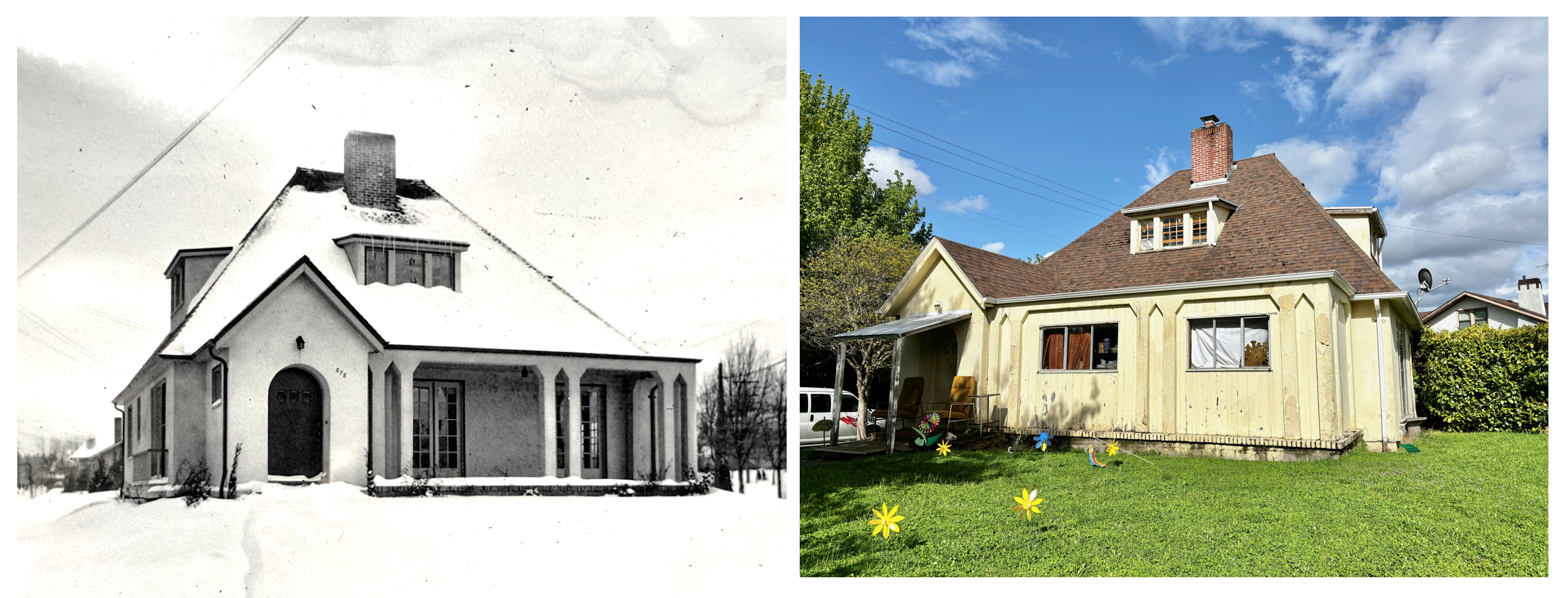
It’s been a fascinating journey so far to understand the story of the von Homeyer house at NE 24th and Mason. The original construction drawings and early photos, the story of the brothers who lived in the house all their lives, and now interesting insights about the front porch, which was enclosed more than 65 years ago.
Maybe you’ve seen the before and after photos that can’t help but make you contemplate earlier days (click in for a a closer look):
Check out the original front porch from the 1920s photo on the left, and as it appears today. Current homeowner Michael Schmitt says he hopes to set the original porch free as he adapts the house for its next century.
As it turns out, the porch was covered over in January and February 1959. We know this according to a request we filed for historic building permits from the Bureau of Development Services, which is something every history-inclined homeowner can do as a way of knowing why things are the way they are today.
To be sure, a good percentage of minor work done on our old houses may have been done without permit, leaving no paper trail. But in this case, adding new exterior walls is documented both with a building permit (issued downtown by the Bureau of Buildings), and an inspection card (filled out in the field by the building inspector). Have a look:
This $350 construction job was done in January 1959 by Harold Burbach using sheeting, siding and aluminum slider windows (but without cutting any new openings on the existing exterior walls or altering the French doors). Evidently the inspector attempted to mark the job as completed during visits in August 1959 and then January 1961, but received no response.
The newly enclosed space created an alcove off the piano teaching studio used by Frances von Homeyer and her many students, perhaps a place to store sheet music, of which Frances had a lot. We’re working on understanding the wide impact Frances’s music and teaching had here in the neighborhood and across Portland, which appears to be significant.
Our request to the Bureau of Development Services for historic building permits and documents also yielded the original 1925 permit and an inspection card that records a straightforward construction process. Both confirm the house was built by Kilgreen and Company for $3,780, that it was built for Hans von Homeyer (who was then living across the river in Vancouver…Frances is not mentioned), and that by Christmas 1925 construction was entering the final stages.
You can request your building permit and inspection cards online (the helpful folks at Resource Records will send you PDFs of any documents in the file for your house) which costs $15. Just a heads up: in our experience about 10-15 percent of houses don’t have any historic permitting documents, or very few…record keeping was not great before the 1920s.
If you do make the request online, you’ll need to provide the county property number for your house, which you can find under the “Assessor Detail” on portlandmaps.com when you look up your address (it starts with an R). If you do go to portlandmaps (which is an amazing data-rich resource), be sure to check out the link to “historic plumbing permits” for your address. These can be just as enlightening as building permits about original owner, builder and pre-address change address, with bonus details about cesspools, vent stacks and all manner of early 1900s plumbing techniques.
There are other resources to learn more about your house and its former occupants. Here’s the list we suggest. This kind of detective work is fun and can lead to all kinds of insights. At our house, it allowed me to find the little boy who grew up here, which led to his photos from 1917 and insights that directly shaped how we rebuilt our front porch, which was the very first post that got AH started way back in 2007.
The next stories from the von Homeyer house will be people stories: Frances and the piano, the amazing photo archive, and interesting images from the early 1900s in Portland and Vancouver. Thanks again to Michael and Jaylen Schmitt who have invited us along on this journey.
Two new profiles to add to The Builders collection, both Swedish immigrants, one who had a brother in the business that we have already profiled, though they chose to spell their last names differently.
Stockholm Harbor, summer 2023
Herman Nelson, who immigrated through Canada in his early 20s a few years ahead of his younger brother builder Emil Nilson; and August Malmquist, or as he is more frequently referred to on building permits as A.C. Malmquist. Learning more about the third Nelson/Nilson brother, Oscar, is still on our to-do list.
Included in all of these profiles is a list of homes built by these builders, so by all means check to see if your address is here.
These three Swedish carpenters built hundreds of houses in Northeast Portland neighborhoods, and operated mostly as Mom-and-Pop businesses, with spouses’ names occasionally showing up on real estate transactions. Their business was building houses, but they were family people too, and were active members in the Swedish community in Oregon.
We are reminded about the contributions made by so many immigrants to the shaping of these neighborhoods, and about the racial restrictions and systems that have kept others away.