Third in the series on Sullivan’s Gulch
Portland’s planning commission of 1926 had dueling visions for what Sullivan’s Gulch could become. One commissioner believed heavy industry was not the right direction, advocating that what hadn’t already been industrialized should be turned into a park.
But C.A. McClure, leader of the planning commission, suggested something different:
“The plans as visualized contemplate an outgoing speedway on the right-hand side of the railroad tracks, an incoming lane on the left-hand side. The object would be to carry the speedway under all viaducts and to have only a few lateral streets, probably one every quarter mile, to feed the through highway.”
This was 1926, 30 years before McClure’s vision became reality. By then, car ownership was on the rise, 13 years after the Broadway Bridge opened when cars first became commonplace. But in 1926, streetcars still ruled ground transportation, just not for long: streetcar ridership had begun to decline.
Meanwhile, interesting things were happening in and around the gulch. In 1926, California oilman, millionaire and developer Ralph B. Lloyd bought hundreds of properties on both sides and was planning a small empire involving a nine-hole golf course and clubhouse, a hotel, and other developments.
Those who favored the gulch as park space had something to feel good about, as expressed in this short editorial in the Oregon Journal on October 1, 1926:
Making the gash in the earth an asset. The gulch, beautified.
Lloyd envisioned an integrated retail, entertainment and residential district that could move Portland’s center of gravity from downtown to the eastside. Among the projects he proposed for the area we think of today as the Lloyd District was a baseball stadium where today’s Rose Garden Arena is; a 400-room eight-story hotel and apartment building just east of Holladay Park; and a series of interesting beautification projects in the lower gulch.
Specifically, Lloyd envisioned a one-mile long linear park in the gulch between Grand Avenue and NE 12th. His preferred method to do this: cap the railroad, creating a long tunnel along the gentle slope to the Willamette River, a beautified park on top.
With the purchase of hundreds of lots in the area of today’s Holladay Park, Lloyd District, Kerns neighborhood and the gulch, Lloyd was well on his way, and he had support on the county commission and city council. But no one could know how the Great Depression, a world war and the car would intervene.
By 1932, Lloyd had changed the gulch from this bucolic view of the 1920s:
Looking southeast up-gulch from about NE 16th in the late 1920s. Click to enlarge. Note the gentle swale, and the older homes near the top of the ravine. The 21st Street Viaduct at far left. Photo courtesy of Oregon Historical Society, OrHi 53652.
To this similar view from 1932, looking east from about NE 15th:
Note the railroad tracks; a service road and retaining wall on the south side of the gulch; houses in the neighborhood on the north bluff; and tons of fill recently trucked into the bottom for golf course greens. Don’t miss the smoke from Doernbecher there in the background. Source: Portland City Archives, image a2009-009-1458.
Lloyd’s lower gulch park never materialized, but a golf course did. In 1930, plans were drawn up and construction begun on a “sporty” nine-hole golf course and driving range in the bottom of the gulch and south slopes between NE 12th and NE 21st. Check out this map and early advertisement in the run-up to grand opening on October 1, 1932:
“Taking the unsightly Sulivan’s Gulch…a beautiful panorama of scenic beauty has been created,” from The Oregonian, September 30, 1932.
Big celebrations surrounded the grand opening and all of Portland was invited to come take a look. One round of golf cost 40 cents, or two for 75 cents. Here’s what John Rooney, manager of the new course, told The Oregonian:
“’Many times a private club member would like to play a round of golf before going to work in the morning, or at the noon hour, but the distance to the course is too great or the course is too long. But a foursome can easily traverse Lloyd’s in an hour and the clubhouse is less than five minutes’ drive from the center of the downtown business district.’”
One reporter wrote his own review of the course:
“Though the nine holes are laid out in a space of not more than 30 acres, the course measures 1,750 yards and there are four tees from which long wooden shots must be made. The greens are the best I have ever played on—they are just about perfect. Sullivan’s gulch only a few years ago was an eyesore. Today, under the magic touch of the landscape engineer backed by the Lloyd financial resources, the railroad ravine has become a thing of beauty.”
Here’s a great photo, by Herb Alden of the Oregon Journal from 1947 looking to the east that takes in the whole course and the surrounding neighborhood.
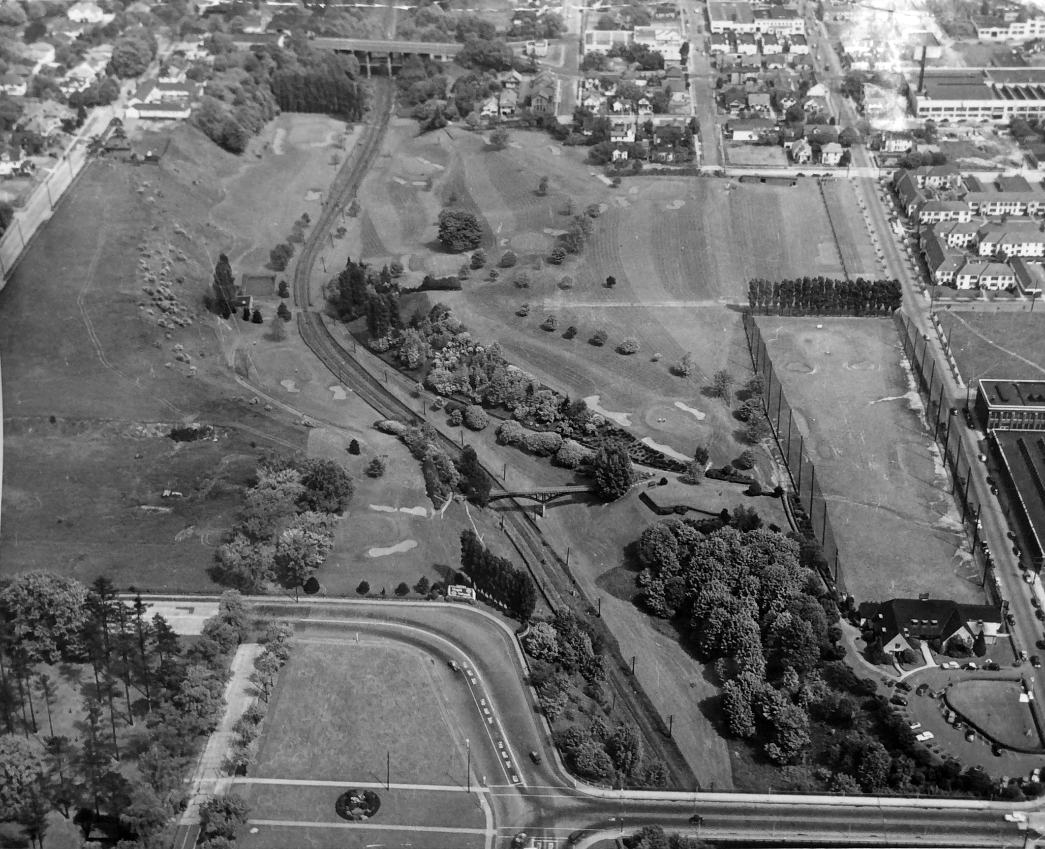
The 12th Avenue viaduct is at the bottom of the photo. To the right is the club house (designed by Charles Ertz), which outlasted the golf course by more than 50 years and was a beautiful building, needlessly demolished in 2017 after serving as Ireland’s Restaurant, Tibbie Dunbar’s, the Polo Club and Point West Credit Union. The fenced area beyond the club house is the driving range (the corner of Benson High School is visible across the street). The 21st Avenue viaduct is at the top of the frame. In the lower left you can see the corner of Holladay Park. A pedestrian footbridge specifically constructed for golfers spans the gulch at about NE 13th. While the grand opening drawing in the 1932 newspaper seems to suggest the train tracks magically disappeared, they were definitely there. No Ralph Lloyd Tunnel.
Here’s a similar view today. The underpass of NE 16th Drive (the yellow line) swings south of today’s Lloyd Center Cinema as it drops briefly into the gulch and travels across the former fifth hole.

Caption: Google Earth photo, circa 2020.
Lloyd died in 1953, but his daughters and business partners pursued his vision which eventually led to development of Lloyd Center in the early 1960s and the surrounding area we know today. The golf course lasted until January 1956, when a force second only to the floods unleashed 12,000 years ago by glacial Lake Missoula remade the gulch: the Banfield Expressway. But that’s for next time.
In the early 1930s—while Lloyd was building the golf course—the wheels had come off the American economy with 25 percent of the workforce unemployed during the worst of the Great Depression: more than 12 million people out of work. The lower gulch became home to a growing number of homeless people who built shacks out of foraged materials. Also called “Hoovervilles” in a sarcastic jab at the former president, Portland had several notable Depression-era settlements including in the gulch and around the Ross Island Bridge.
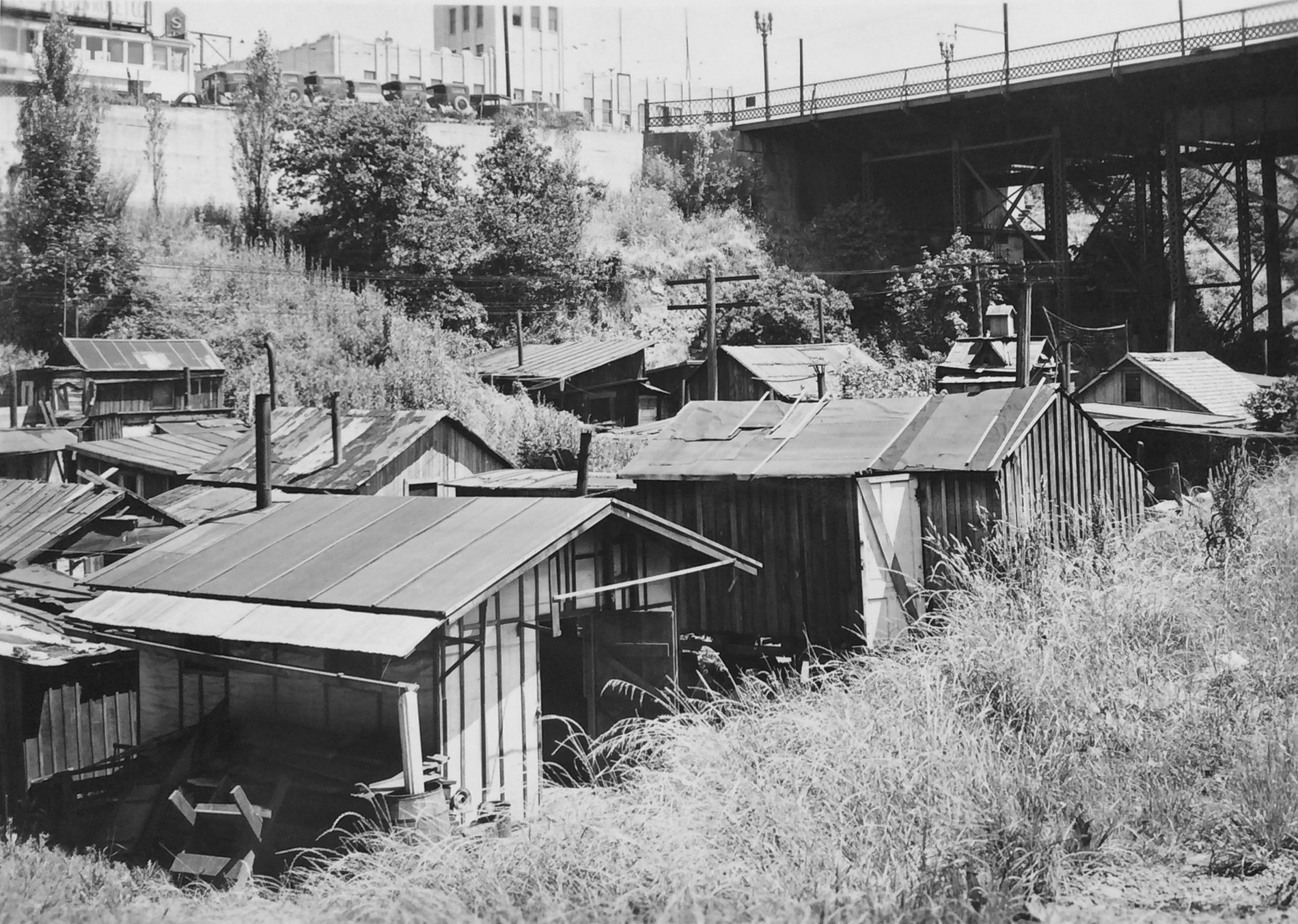
Looking to the north just west of the Grand Avenue overpass, the old Sears building above on the bluff, home to today’s Metro building. Source: Oregon Historical Society Negative COP 00152
Beginning in about 1932, unemployed men (mostly) began building shacks in the gulch, clustered at first under the Grand Avenue viaduct, and then eventually stretching up to the 12th Avenue overpass and then farther up-gulch under most of the viaducts.
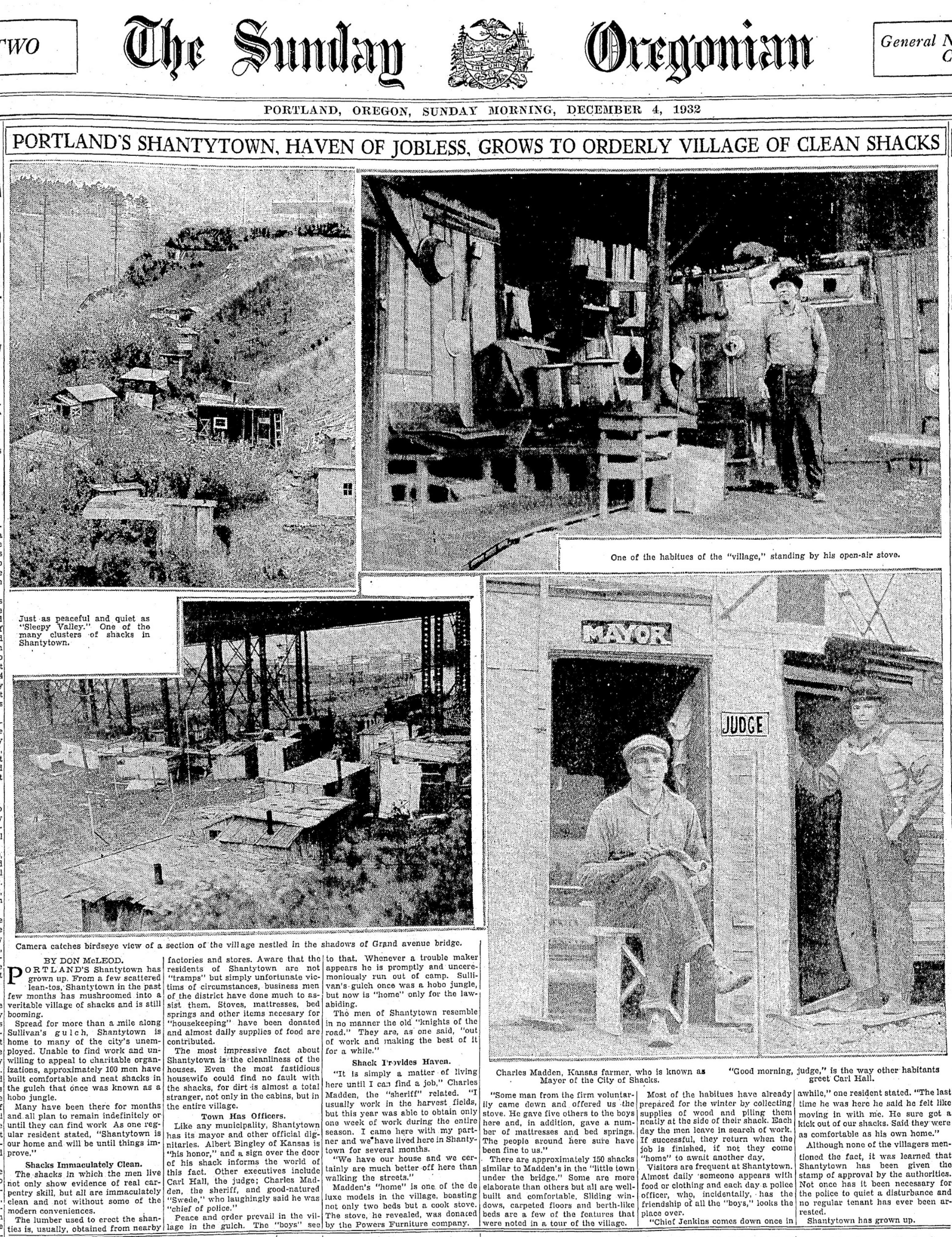
Front page of the Sunday Oregonian, December 4, 1932. The photo in upper left of this spread is looking up-gulch, the trees of Holladay Park can be seen on the bluff to the left. Lower left is another view of the area under the Grand Avenue overpass.
As Lloyd corporation workers cleared brush in the gulch and maintained golf course landscaping, they also cleared parts of Shantytown by burning shacks. Residents persisted there until the last shack was burned in July 1941.
By then, engineers with the Highway Commission were preparing a plan to bring to voters…
Next: Portland gets a highway it doesn’t want


How fascinating was this article Doug!! Interesting that Lloyd felt that Portland need not be ugly!! Glad he could not see it today!! Also interesting was the Shantytown..very organized and neat looking even though they were homeless..again glad no one can see it today…Maybe you should send this particular article to the mayor and commissioners!!
Thanks again
Bev Renne
On Wed, Nov 24, 2021 at 7:19 AM Alameda Old House History wrote:
> Doug posted: ” Third in the series on Sullivan’s Gulch Portland’s planning > commission of 1926 had dueling visions for what Sullivan’s Gulch could > become. One commissioner believed heavy industry was not the right > direction, advocating that what hadn’t already been ” >
Doug, I really enjoy the details and history in your articles. It’s great that you set up the images so they can be downloadedand enlarged. I grew up in NE Portland at 52nd and Sumner so many of your Alameda articles bring back memoriesand explain earlier history I didn’t know.
Your latest on the Lloyd Golf Course reminded me of some web research I did after taking the Architectural Heritage tourof the Sullivan’s Gulch Neighborhood in 2018. I think you will enjoy the detail in the attached 1942 golf magazine article I found.It gives a pretty good description of the golf course and claims that the driving range fence was “the highest fence in the world” at85 feet tall. Thanks for your postings!
John Hunt