The AH blog has been quiet lately because it’s been a very busy winter on many research fronts: specific homes and their builders and people; intersections that are undergoing significant change; the incredible story of three very specific long-lost panels of ornamental glass and the wonder of window restoration and sash making; puzzling questions about everything from street alignments (why is that bend there?), to front porches (what happened to my front porch?). Some interesting things to share in the weeks ahead.
Meanwhile, here are four fresh photos to wake things up a bit, echoing through from our recent series on Sullivan’s Gulch and the arrival of the Banfield Expressway.
You’ve driven past these buildings a million times: part of today’s big U-Store complex on the north side of the Banfield (I-84) at NE 28th, just west of the Hollywood West Fred Meyer.
Here’s a link to the installment from our Sullivan’s Gulch series that references the Doernbecher Furniture Company buildings, which you can still find today if you turn east off of NE 28th at Sullivan Street, just south of the Banfield. Go down that hill, through the tunnel, cross the tracks and take a look. The crossing is in the same place as it appears in this 19-teens photo above, courtesy of the Oregon Historical Society.
Here’s an even earlier westward view of the Gulch that we’ve come across, taken in the early 1900s just below where the State of Oregon office building is today on Lloyd Boulevard. The photo was taken to document progress on the trunk sewer that was constructed down the gulch (you can see it there in the bottom…the man is walking along the top of it). By triangulating the photo with old Sanborn Fire Insurance maps, our hunch is the houses on the brow of the gulch are at the corner of 7th and Irving. Look carefully, you can see the two towers of the Steel Bridge through the haze to the west.
Trunk sewer in Sullivan’s Gulch, looking west. From OHS photo file on Sullivan’s Gulch
The trunk sewer–and what went in it–was the source of legal wrangling between the various new subdivisions upstream that all wanted to dump their waste into it (but didn’t want to pay for it). The contents were still headed for open water in the Willamette River (not good), but the trunk sewer was an improvement over earlier more primitive ways of sewage disposal.
And our last gem below shows a 1930s view of the clubhouse at the old Lloyd Golf Course. This graceful building, now gone, sat near NE Irving at about 13th (across from Benson High School) and was the gateway to the old golf course.
Here’s more about the Lloyd Golf Course era, and one last photo below from AH reader Steve Goodman showing the building’s later days after the golf course was gone (and when Steve was learning to wash dishes in the dishroom of this very building).
During the Great Depression and the war years of the 1940s, Portlanders had more pressing things to think about than the future of Sullivan’s Gulch. If they thought about the gulch at all, it might have been about their jobs at Doernbecher’s furniture factory, or an escape to Lloyd’s golf course, or the sprawling Hooverville-shantytown at the mouth of the gulch.
Before the speedway: looking west down Sullivan’s Gulch through the Lloyd Golf Course, just west of the NE 21st Avenue viaduct, December 1947. The driving range fence and a corner of Benson High School are visible in upper left. Photo courtesy of Oregon Historical Society, OrHi 91595.
Through those tough years, many families and small businesses struggled just to make ends meet. A quick look at the census shows how many homes on the eastside took in a boarder or two, or had extended family living under the same roof. And if you were a citizen of color or an immigrant, the Portland establishment was more about keeping you down than helping you up.
An influx of workers associated with shipyards and the World War 2 effort brought continued growth particularly on the eastside, and further industrialization along the Willamette and Columbia rivers. Between 1920-1950, our population increased by more than 115,000 people.
Many of those people had cars.
Completion of the Ross Island and Burnside bridges in the mid 1920s allowed direct access to downtown from the eastside. The Ross Island Bridge, completed in 1926, was the first major Willamette crossing that did not include a streetcar route, an important choice and signal of things to come.
By the late 1920s, automobile use had outpaced streetcar ridership and east-west arterials were increasingly clogged with car commuters morning and night. Between 1913 when the Broadway Bridge opened and 1928, the total number of automobile registrations in Oregon increased from 10,165 to 256,527. A powerful force had been unleashed that was going to re-make the landscape.
Another indication of our early car-related growing pains: in 1927 voters approved a street widening levy that literally remade Burnside Street by removing entire portions of buildings and adding street lanes to cope with increased traffic. Similar work took place on Northeast Broadway in the early 1930s.
Looking west at NW 6th and Burnside during the widening project. Buildings on both sides of the street were cut back to make way for more lanes and more traffic. This was not a popular move as Portland struggled with growing pains. Photo courtesy City of Portland Archives, image a2001-062-2
Despite these changes—or perhaps because of them—City Council received an increasing number of complaints about traffic on Fremont, Broadway, Burnside, Stark and Hawthorne. The writing was on the wall for a bigger traffic congestion “fix.”
In 1944, City Commissioner William Bowes brought up C.A. McClure’s earlier Planning Commission speedway vision. The State Highway Commission—chaired by T. Harry Banfield—was on board and suggested the city not grant any more building permits along the Sullivan’s Gulch right of way. If the speedway vision was going to come to pass, it was time to stop allowing development along the edges of the gulch. By agreeing, Portland inched closer to endorsing the project.
As the war years ended, the topic rose to the top of Portland civic life and news coverage.
From The Oregonian, February 24, 1946
City Council placed a money measure for the expressway on the May 21, 1948 ballot asking if Portland voters were ready to pass a $2.4 million tax levy for the city’s share of a $10.5 million project to build a gulch expressway that would theoretically ease traffic problems. Interestingly, also on the ballot that day was a city ordinance requiring the leashing of all dogs…council didn’t want to be alone with just its fingerprints on that explosive decision either.
The resulting public dialog and advertising campaign about the expressway levy produced fireworks as people and businesses chose sides:
From The Oregonian, May 20, 1948
From The Oregonian, May 19, 1948
Portland City Club added its voice and recommendation with a report considering the pros and cons of the expressway, including an awareness for Portlanders that construction would require demolition of more than 110 homes along the right-of-way.
The results of the vote were an unequivocal no: Portland was not interested. (Results of the dog leashing ordinance were far less clear: it was defeated by a mere 4 percent margin).
From The Oregonian, May 24, 1948
But the establishment was strong and within a week, the Oregon Transportation Commission went ahead anyway with survey and planning work to prepare for major right-of-way acquisition. Spurned by Portland voters, T. Harry Banfield and the commission decided to look elsewhere to fund the speedway vision.
During the week after the landslide vote, The Oregonian editorial board expressed its surprise about the Highway Commission’s decision to go ahead anyway, but endorsed the new highway as necessary for progress:
From The Oregonian, May 27, 1948
Soon, things began to happen, with tangible progress beginning to show on the eastern end of the project and then proceeding west toward downtown. Portions of neighborhoods were bought and houses moved or demolished:
From the Oregon Journal, August 21, 1949
Later in 1949, the Highway Commission had to revise right-of-way acquisition costs upward from $2.4 million to $4.8 million. In August 1950, T. Harry Banfield died while on a fishing trip in Gold Beach, but the vision was well on its way into implementation. By early 1952, the first construction contract for grading at the far eastern end of the highway in the Fairview area had been let for $400,000. In March of 1955, the Doernbecher factory in the gulch at NE 28th Avenue closed and its furniture-making machinery sold at auction. In January of 1956, seven of the Lloyd Golf Course putting greens were sold to Riverside Golf and Country Club for an undisclosed price.
Photos from the 1950s make it clear just how much gulch-widening and dirt moving would be required, particularly in the big bends between NE 21st and NE 37th.
Oregon Journal photo from June 3, 1956, early on in the construction process. Looking up-gulch east from the 21st street viaduct, the rail line visible on the left is running up the bottom of the old gulch and the excavating equipment is widening the south bank with lots more work to do to make it wide enough. Caption on the photo reads “Banfield freeway is being gouged from the earth.” Photo courtesy of Oregon Historical Society.
On October 1, 1955, the highway opened between NE 42nd and Troutdale. Two years later, with funds from the major highway infrastructure bill signed into law by President Eisenhower, the final two miles were completed. By 1960, the Banfield Freeway was fully operational and a century of transformation in the gulch was complete, from natural area to homestead to manufacturing hub, golf course and shantytown.
The deep curves west of the Hollywood neighborhood and the last western stretch to downtown, from the Oregon Journal, September 23, 1957. “Paving of Banfield route progresses. This aerial view looks east from above NE 28th avenue viaduct. At lower left is old Doernbecher furniture manufacturing plant. Upper viaduct is NE 33rd avenue. Only one small stretch above 33rd avenue viaduct is unpaved.” The Hyster plant is also visible in the upper left corner. Courtesy of Oregon Historical Society.
Despite all the changes brought about by the speedway vision, some weren’t quite ready to embrace the gulch’s new identity. A grass-roots campaign that began (and ended) in Parkrose attempted to claim local history, reminding us once again about the importance of places and their names.
Today, it remains the Banfield. But some of us know it’s still Sullivan’s Gulch.
From the Oregon Journal. Banfield Expressway looking west from NE 12th Avenue Viaduct, about 1960. Photo courtesy of Oregon Historical Society.
Portland’s planning commission of 1926 had dueling visions for what Sullivan’s Gulch could become. One commissioner believed heavy industry was not the right direction, advocating that what hadn’t already been industrialized should be turned into a park.
But C.A. McClure, leader of the planning commission, suggested something different:
“The plans as visualized contemplate an outgoing speedway on the right-hand side of the railroad tracks, an incoming lane on the left-hand side. The object would be to carry the speedway under all viaducts and to have only a few lateral streets, probably one every quarter mile, to feed the through highway.”
This was 1926, 30 years before McClure’s vision became reality. By then, car ownership was on the rise, 13 years after the Broadway Bridge opened when cars first became commonplace. But in 1926, streetcars still ruled ground transportation, just not for long: streetcar ridership had begun to decline.
Meanwhile, interesting things were happening in and around the gulch. In 1926, California oilman, millionaire and developer Ralph B. Lloyd bought hundreds of properties on both sides and was planning a small empire involving a nine-hole golf course and clubhouse, a hotel, and other developments.
Those who favored the gulch as park space had something to feel good about, as expressed in this short editorial in the Oregon Journal on October 1, 1926:
Making the gash in the earth an asset. The gulch, beautified.
Lloyd envisioned an integrated retail, entertainment and residential district that could move Portland’s center of gravity from downtown to the eastside. Among the projects he proposed for the area we think of today as the Lloyd District was a baseball stadium where today’s Rose Garden Arena is; a 400-room eight-story hotel and apartment building just east of Holladay Park; and a series of interesting beautification projects in the lower gulch.
Specifically, Lloyd envisioned a one-mile long linear park in the gulch between Grand Avenue and NE 12th. His preferred method to do this: cap the railroad, creating a long tunnel along the gentle slope to the Willamette River, a beautified park on top.
With the purchase of hundreds of lots in the area of today’s Holladay Park, Lloyd District, Kerns neighborhood and the gulch, Lloyd was well on his way, and he had support on the county commission and city council. But no one could know how the Great Depression, a world war and the car would intervene.
By 1932, Lloyd had changed the gulch from this bucolic view of the 1920s:
Looking southeast up-gulch from about NE 16th in the late 1920s. Click to enlarge. Note the gentle swale, and the older homes near the top of the ravine. The 21st Street Viaduct at far left. Photo courtesy of Oregon Historical Society, OrHi 53652.
To this similar view from 1932, looking east from about NE 15th:
Note the railroad tracks; a service road and retaining wall on the south side of the gulch; houses in the neighborhood on the north bluff; and tons of fill recently trucked into the bottom for golf course greens. Don’t miss the smoke from Doernbecher there in the background. Source: Portland City Archives, image a2009-009-1458.
Lloyd’s lower gulch park never materialized, but a golf course did. In 1930, plans were drawn up and construction begun on a “sporty” nine-hole golf course and driving range in the bottom of the gulch and south slopes between NE 12th and NE 21st. Check out this map and early advertisement in the run-up to grand opening on October 1, 1932:
“Taking the unsightly Sulivan’s Gulch…a beautiful panorama of scenic beauty has been created,” from The Oregonian, September 30, 1932.
Big celebrations surrounded the grand opening and all of Portland was invited to come take a look. One round of golf cost 40 cents, or two for 75 cents. Here’s what John Rooney, manager of the new course, told The Oregonian:
“’Many times a private club member would like to play a round of golf before going to work in the morning, or at the noon hour, but the distance to the course is too great or the course is too long. But a foursome can easily traverse Lloyd’s in an hour and the clubhouse is less than five minutes’ drive from the center of the downtown business district.’”
One reporter wrote his own review of the course:
“Though the nine holes are laid out in a space of not more than 30 acres, the course measures 1,750 yards and there are four tees from which long wooden shots must be made. The greens are the best I have ever played on—they are just about perfect. Sullivan’s gulch only a few years ago was an eyesore. Today, under the magic touch of the landscape engineer backed by the Lloyd financial resources, the railroad ravine has become a thing of beauty.”
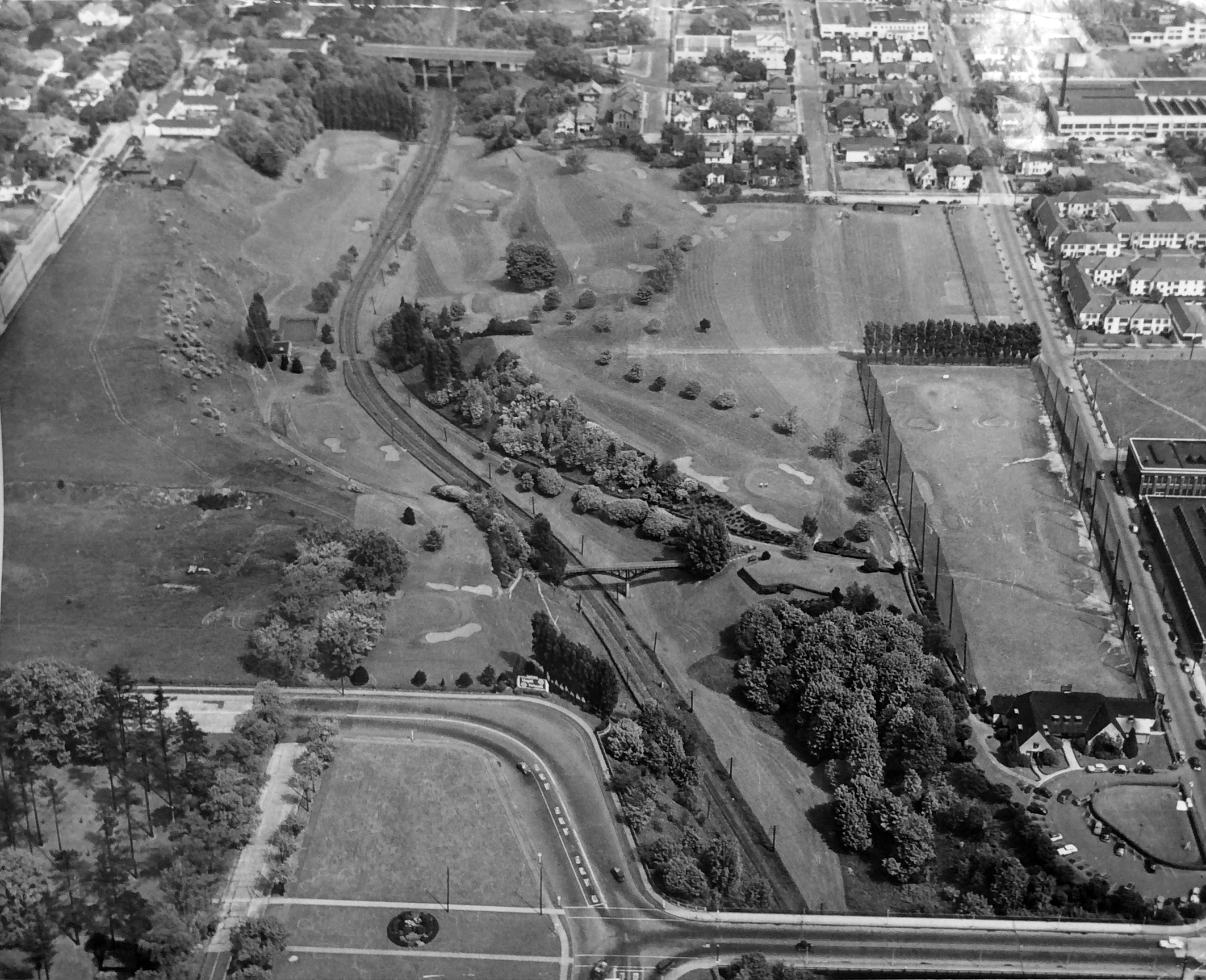
Here’s a great photo, by Herb Alden of the Oregon Journal from 1947 looking to the east that takes in the whole course and the surrounding neighborhood.
The 12th Avenue viaduct is at the bottom of the photo. To the right is the club house (designed by Charles Ertz), which outlasted the golf course by more than 50 years and was a beautiful building, needlessly demolished in 2017 after serving as Ireland’s Restaurant, Tibbie Dunbar’s, the Polo Club and Point West Credit Union. The fenced area beyond the club house is the driving range (the corner of Benson High School is visible across the street). The 21st Avenue viaduct is at the top of the frame. In the lower left you can see the corner of Holladay Park. A pedestrian footbridge specifically constructed for golfers spans the gulch at about NE 13th. While the grand opening drawing in the 1932 newspaper seems to suggest the train tracks magically disappeared, they were definitely there. No Ralph Lloyd Tunnel.
Here’s a similar view today. The underpass of NE 16th Drive (the yellow line) swings south of today’s Lloyd Center Cinema as it drops briefly into the gulch and travels across the former fifth hole.
Caption: Google Earth photo, circa 2020.
Lloyd died in 1953, but his daughters and business partners pursued his vision which eventually led to development of Lloyd Center in the early 1960s and the surrounding area we know today. The golf course lasted until January 1956, when a force second only to the floods unleashed 12,000 years ago by glacial Lake Missoula remade the gulch: the Banfield Expressway. But that’s for next time.
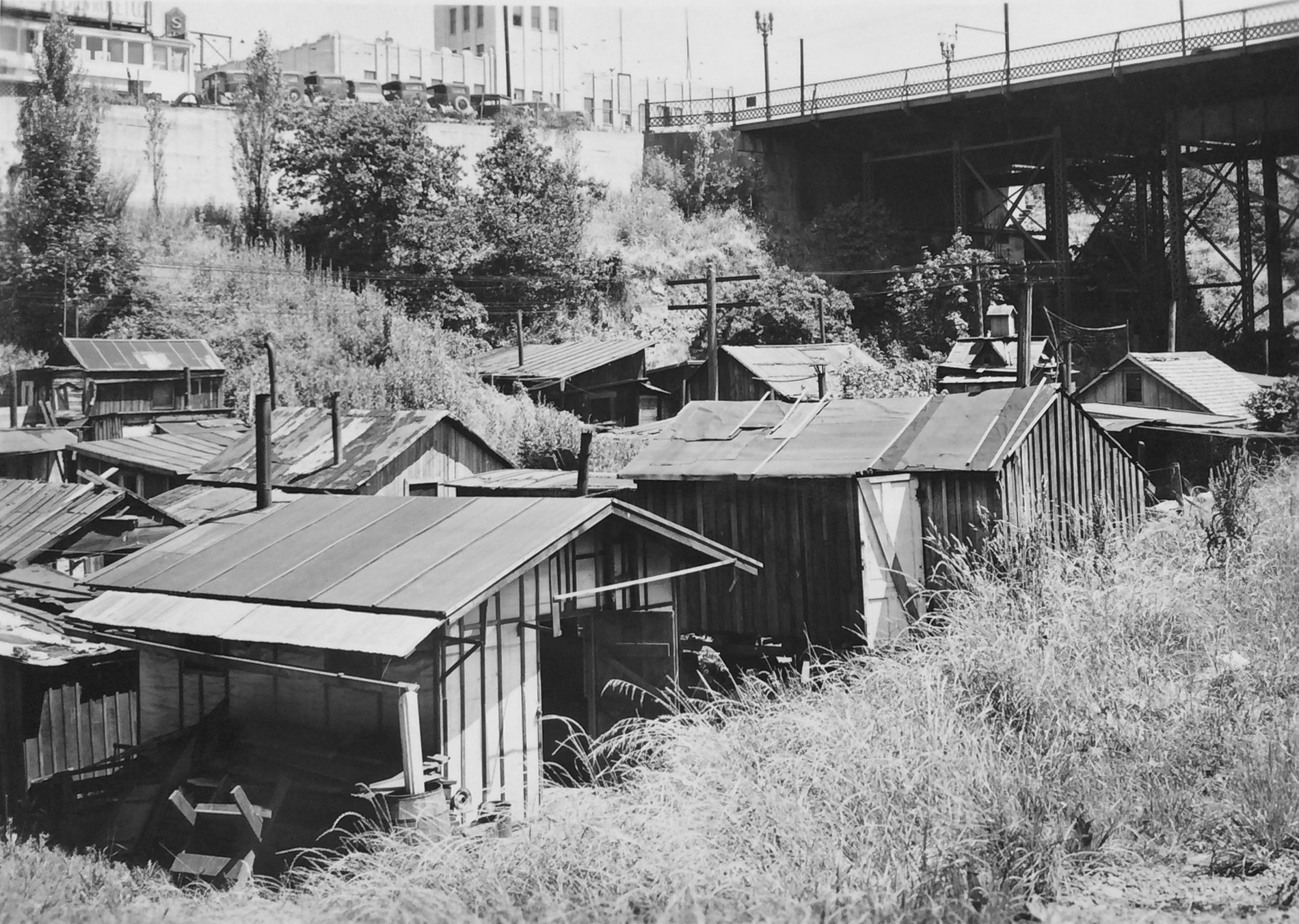
In the early 1930s—while Lloyd was building the golf course—the wheels had come off the American economy with 25 percent of the workforce unemployed during the worst of the Great Depression: more than 12 million people out of work. The lower gulch became home to a growing number of homeless people who built shacks out of foraged materials. Also called “Hoovervilles” in a sarcastic jab at the former president, Portland had several notable Depression-era settlements including in the gulch and around the Ross Island Bridge.
Looking to the north just west of the Grand Avenue overpass, the old Sears building above on the bluff, home to today’s Metro building. Source: Oregon Historical Society Negative COP 00152
Beginning in about 1932, unemployed men (mostly) began building shacks in the gulch, clustered at first under the Grand Avenue viaduct, and then eventually stretching up to the 12th Avenue overpass and then farther up-gulch under most of the viaducts.
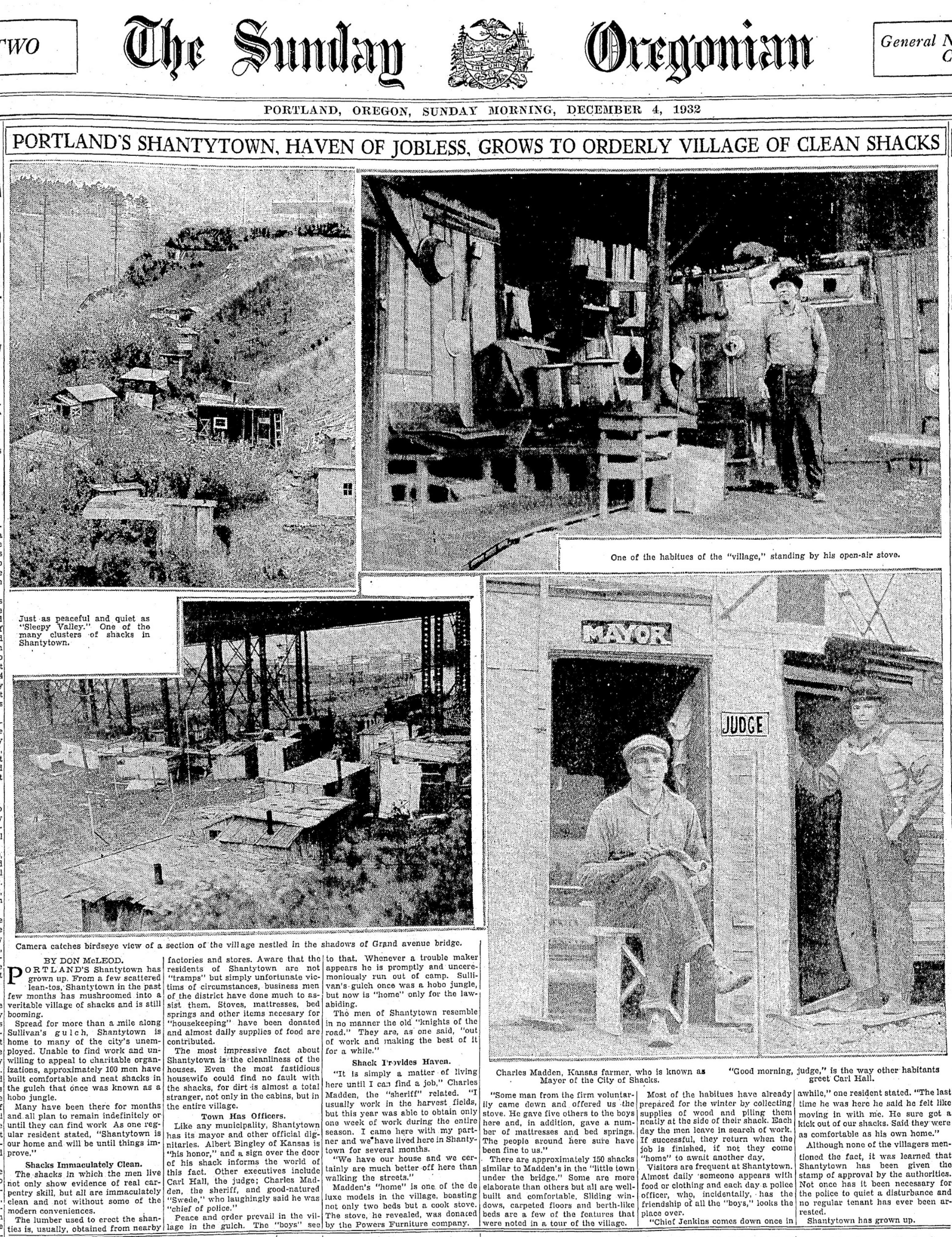
Front page of the Sunday Oregonian, December 4, 1932. The photo in upper left of this spread is looking up-gulch, the trees of Holladay Park can be seen on the bluff to the left.Lower left is another view of the area under the Grand Avenue overpass.
As Lloyd corporation workers cleared brush in the gulch and maintained golf course landscaping, they also cleared parts of Shantytown by burning shacks. Residents persisted there until the last shack was burned in July 1941.
By then, engineers with the Highway Commission were preparing a plan to bring to voters…