Over the years, we’ve heard the notion that there was once a gravel pit and then a garbage dump at the corner of NE 33rd and Fremont. We remember in the 1990s when the house at the southwest corner—the one with the old swimming pool out back—was removed because of major foundation problems, which seems like reasonable evidence of the underlying problem.
But we wanted to know more, so we tracked down the details. Let’s start with a photo to put you in context.
Here is the area in a 1925 aerial photo, the earliest one we know of. There’s lots to look at here, but start at the large vacant lot in the lower right hand corner. The street running east-west is Fremont and the vacant lot just below it to the south is actually three blocks, between today’s NE 32nd Avenue on the left and “E 33rd” on the right. 32nd Place (then known as Glenn Avenue before the Great Renumbering) does not yet go through.
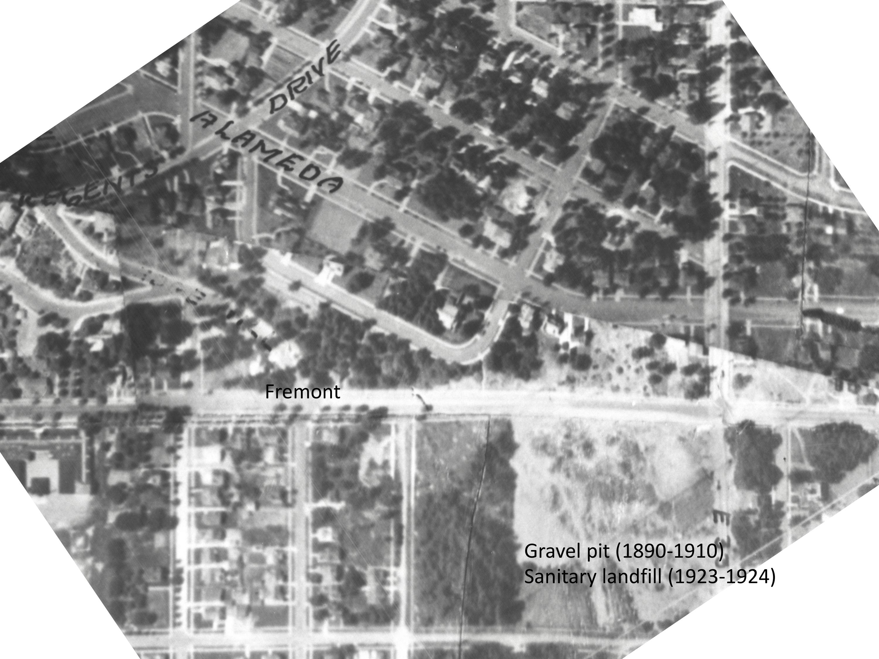
Detail from a 1925 aerial photo showing the intersection of Fremont and 33rd, two labels added for reference. Click to enlarge. Aerial photo courtesy of City of Portland Archives.
That’s a pretty steep slope to the south (just ask local kids with sleds hoping for snowfall) which is one reason it’s one of the few unbuilt pieces of ground you can see in this photo.
Be sure to check out these historic photos of the area discovered in 2024 and depicting the pit in 1913.
Back in the late 1890s and up until about 1910, that slope was heavily excavated for gravel, which makes sense. It’s right along the crest of the Alameda Ridge, which after all is one giant gravel deposit left over from the cataclysmic Lake Missoula Floods of 13,000-15,000 years ago. The Fremont gravel pit provided tons of rock for a young and growing Portland, which was busy building roads. In those early years, 33rd and Fremont even became known as Gravelly Hill, a name that stuck around for decades (we try to slip that name into a conversation whenever we can, you should try it just to keep it alive).
In the photo, you can see the disturbed area at the top of the slope all along the southern edge of Fremont. That was the top of the gravel pit. A few years later it was also the top of the garbage dump.
In 1910, Benjamin Lombard, who developed the Olmsted Park plat which you can see just up the hill in this photo (now considered part of the Alameda neighborhood), sued the city for violating its own ordinance that prohibited gravel pits within 100 feet of a public street. Fremont was a city-owned street, plus the city owned a good chunk (but not all) of that vacant lot to the south too. East 33rd had long been known simply as the County Road and was the county’s responsibility.
A letter to county commissioners in August 1910 reported “the roadway at Thirty-third and Fremont streets is in danger of caving in because of excavation in the Fremont gravel pit.” The county passed this complaint along to the city, which was also hearing from Lombard about the same time. Due to the undercutting of the slope required by the gravel mining operations, Fremont Street was just about ready to slide down the hill.
This 1910 kerfuffle ended the slope’s official function as a gravel pit, though other places—notably a nearby hollow on privately owned land at the corner of today’s NE 37th and Klickitat—stepped in to meet the gravel need.
Fast forward to the early 1920s. Portland was booming and rapidly running into a garbage disposal problem. The city’s Guilds Lake Incinerator, located in Northwest Portland at NW 25th and Nicolai, was operating at full capacity and the city needed to find another way to deal with garbage.
William G. Helber, Portland’s Superintendent of Garbage Disposal, had visited Seattle and seen a new technique called “sanitary fill,” whereby garbage was mixed with dirt and buried in layers on uneven ground. This had the double “benefit” of disposing of garbage and leveling off land that could then be used or sold for other uses.
When Helber looked out across the Portland landscape, he fixed on several locations he believed would function well as sanitary fills.
 From The Oregonian, January 16, 1923
Because the city didn’t own the downslope part of the hill, it took some creative deal making with the adjacent private owner to make it all work. Downslope owners Joe and Frances Brooks also owned the gravel pit at 37th and Klickitat. They agreed to let the city use the lower end of the Fremont pit for the garbage fill as long as the city would also fill up their old gravel pit on Klickitat with garbage. This site became known as the “Beaumont Fill.” The Brooks were then free to sell that as viable real estate to the developer who wanted to build houses there.
Not everyone was happy with the idea of burying garbage so close to existing homes. Alameda neighbors, who were always ready to protest (schools, camps, churches), were particularly skeptical. But Helber took them out on the ground to have a look at what he had in mind and the neighbors seemed satisfied to give it a try.
 From The Oregonian, January 20, 1923
Starting in February 1923 through June 1924, all non-commercial trash from Portland’s eastside was hauled to Alameda to fill up the old Fremont gravel pit.
From The Oregonian, February 7, 1923
When the summer of 1923 rolled around, everyone held their breath (and their noses) wondering if the heat and the garbage would create a smelly problem. No news must have been good news, because there was no further coverage.
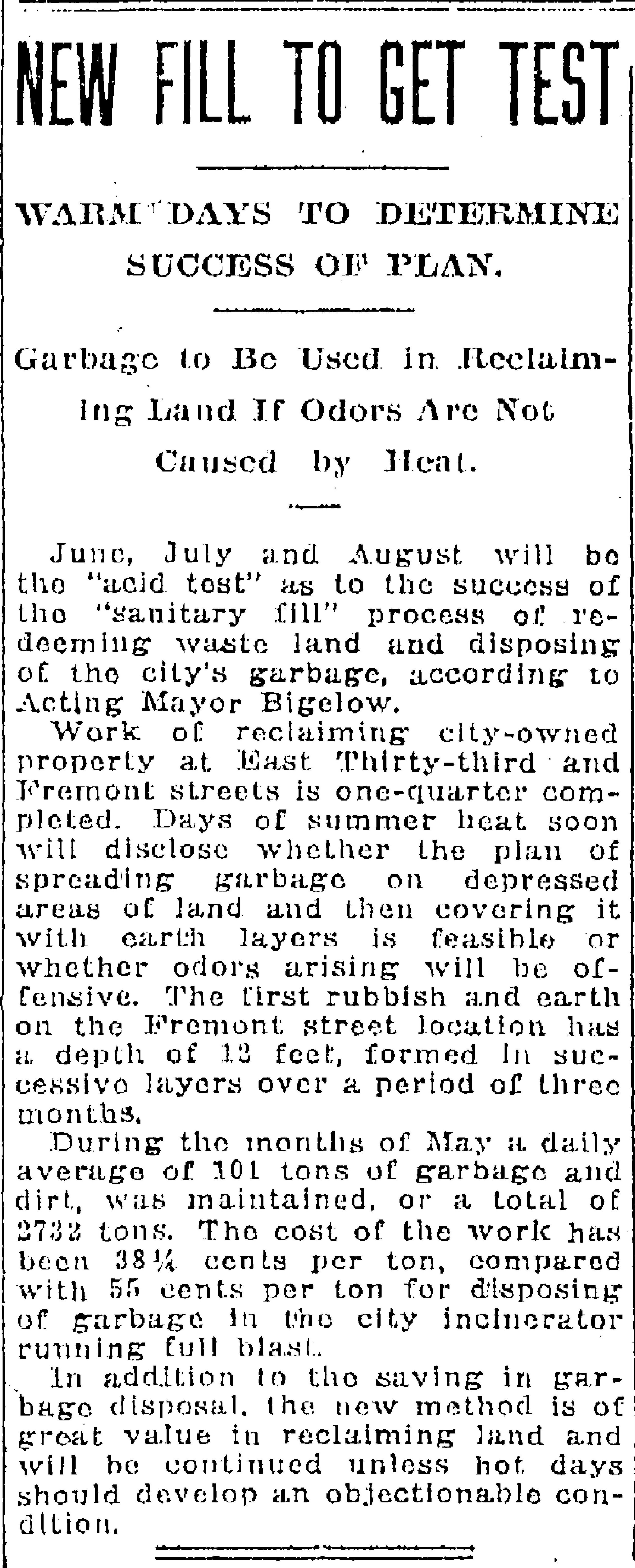
From The Oregonian, June 6, 1923
Here’s a great photo from the early 1930s that shows both of the completed sanitary fills (and so much else to look at). We love this photo.

Aerial oblique photo from the early 1930s shows both former fill sites and a lot more, including a very brushy Wilshire Park and the new Beaumont School. Click to enlarge this amazing photo.
In 1924, one year after opening when it became time to shut down the Fremont Sanitary Fill, the city realized it had trained all of east Portland to bring its trash to Alameda, and that it would probably take some retraining and even some enforcement to break the habit.
From The Oregonian, May 30, 1924
In a final accounting contained in his January 1926 report to City Commissioner Charles A. Bigelow, Garbage Disposal Bureau Director Helber summarized the following statistics for the Fremont Street Sanitary Fill:
- Estimated number of loads of garbage received: 1,618
- Average number of loads received per day: 62 ½
- Average tons of garbage dumped each day: 136
- Estimated tons of garbage dumped: 3,541 ½
- Average yards of dirt received per day: 3 ½
- Total salary of all dump workers per month: $442
- Monthly installment on new tractor used on site: $121.25
That’s a lot of garbage. Sixty-two loads arriving at the top of the hill on Fremont Street each day for more than a year, dumped over the edge, spread by tractor down the slope and covered over with a little dirt.
The city continued to use the sanitary fill method in other areas as it planned a larger incinerator—a long drawn out process because no neighborhood wanted it in their backyard—which was ultimately built in 1932 in St. Johns and is known today as Chimney Park.
But in the meantime while incinerator planning and location were being fought about in City Hall, the fill method was gaining critics. Here’s news of neighbors at NE 37th and Alberta (today’s Alberta Court) complaining about the stench to City Council.

From The Oregonian, October 20, 1927
Back at the Fremont fill in the early 1940s, home construction was just getting underway. Here’s a photo from 1943.
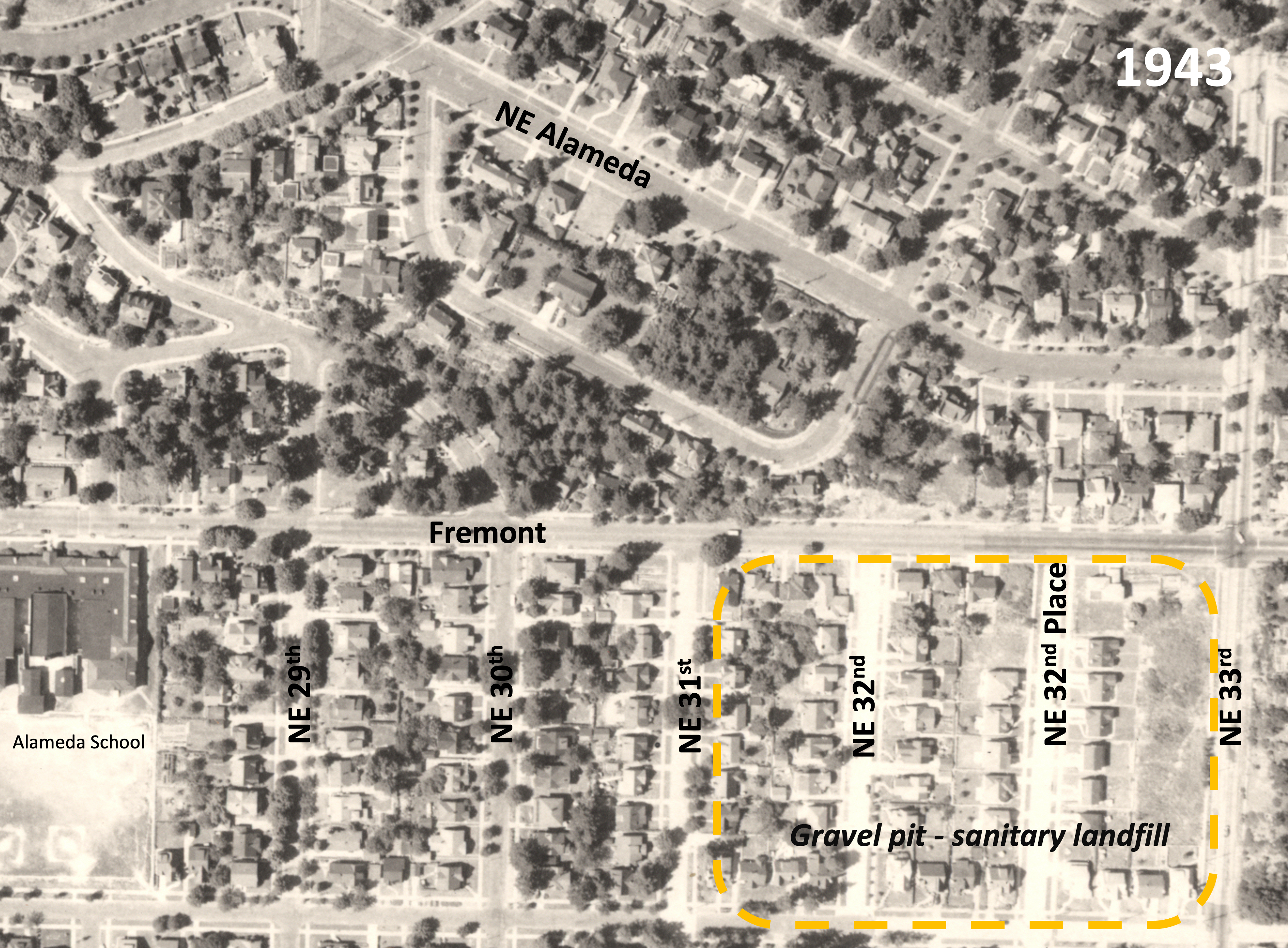
Detail from a 1943 aerial photo, dashed orange added to show former gravel pit and fill area.


Doug, As I’m sure you know, the reason for all the gravel that created the Alameda ridge was because, thousands of years ago, the Bretz (Missoula) floods came sweeping into the Portland area from the Columbia River gorge. The entire Oregon-Washington-Montana area was inundated many times as ice dams from the last ice age broke apart and washed down the Columbia as the temperature warmed. That’s why our gardens are so full of rocks today. Those rocks generate the radon gas we have to deal with in this area.
Hi Margaret. Thanks for the comment. I invite you to check out the link about the Bretz floods I embedded in the post that shows the extent of the flood waters in this area and the deposits they left behind: https://www.oregongeology.org/pubs/ims/IMS-036_print.pdf
We were well under water…
Great story..I bought a home on 32nd place (second house down from fremont) in 1980 and every time I worked in my yard, I brought up pieces of China and glass…this article explains why!!
Hi Beverly, I just read a page on portland.gov that explained that garbage service was largely unregulated until the 1980s. It was a free market system. Given what we know about the history of racism in Oregon and poverty in our neighborhood, it stands to reason that many residents buried their trash because they simply could not afford garbage service or had little access to it. Our home is on 10th and Alberta and we still recover artifacts from bygone days.
Doug,
Thanks for the interesting article. As I was reading, I remembered some old research I did as a member of the Alameda and Beaumont PTAs. Prior to their construction, temporary sites were selected for each school. The Alameda site was at 33rd and Fremont or in those days, and as of today, the former gravel pit.
I’ve attached an article I clipped from Sept. 18, 1914. For reference. Apparently folks were not happy as they clamored for replacement of the temporary structures just a year later on October 14, 1915.
Fellow history nerd,
Pete Conklin ________________________________
My husband and I were the ones who bought the house with the swimming pool on the corner of 33rd and Fremont in the ’90’s. Before we bought it we had two different geological engineering firms test the soil and evaluate it’s stability. Both said that it was stable and leveling the house could easily be done. Both were wrong. The cost to stabilize the house was beyond our resources. Fortunately, a grade school classmate, Terry Emmert, offered to buy the house and Move it to become the first remolded home on the Street of Dreams. We sold the lot with all the engineering studies to a builder who hopefully did what was required to stabilize the land before he build what is there today.
A little bit more history about the house. I grew up in Laurelhurst in the 50’s-60’s. Our family drove by that house regularly on the way to Riverside Country Club, where we were members. My father told us about the house. My father’s friend, who owned the well known Fox Furniture Co., built the house with the swimming as a wedding gift to his daughter and her husband and that it was built and finished to the highest quality. That certainly was true, except for understanding the engineering of the foundation.
Doug, thanks for the article. It brought back poignant memories of a very special home that we were not able to save, but loved none the less.
Thank you, Judy, for sharing your insights about the house. An AH reader has shared a photo of the house from 1962 and I’m preparing a follow-up post with the photo and your insights as “the rest of the story.”
What an interesting article! When I was in the 2nd and 3rd grades, (1967 /68) our family lived in the home located on the NW corner of 33rd and Fremont. Being that young at the time, I didn’t have an appreciation for the history of the area, but today I do, so it was a pleasure to find this article. Thank you for doing all of the in-depth research on this and sharing it.
Frank Barnes’ place straddled two landfills?