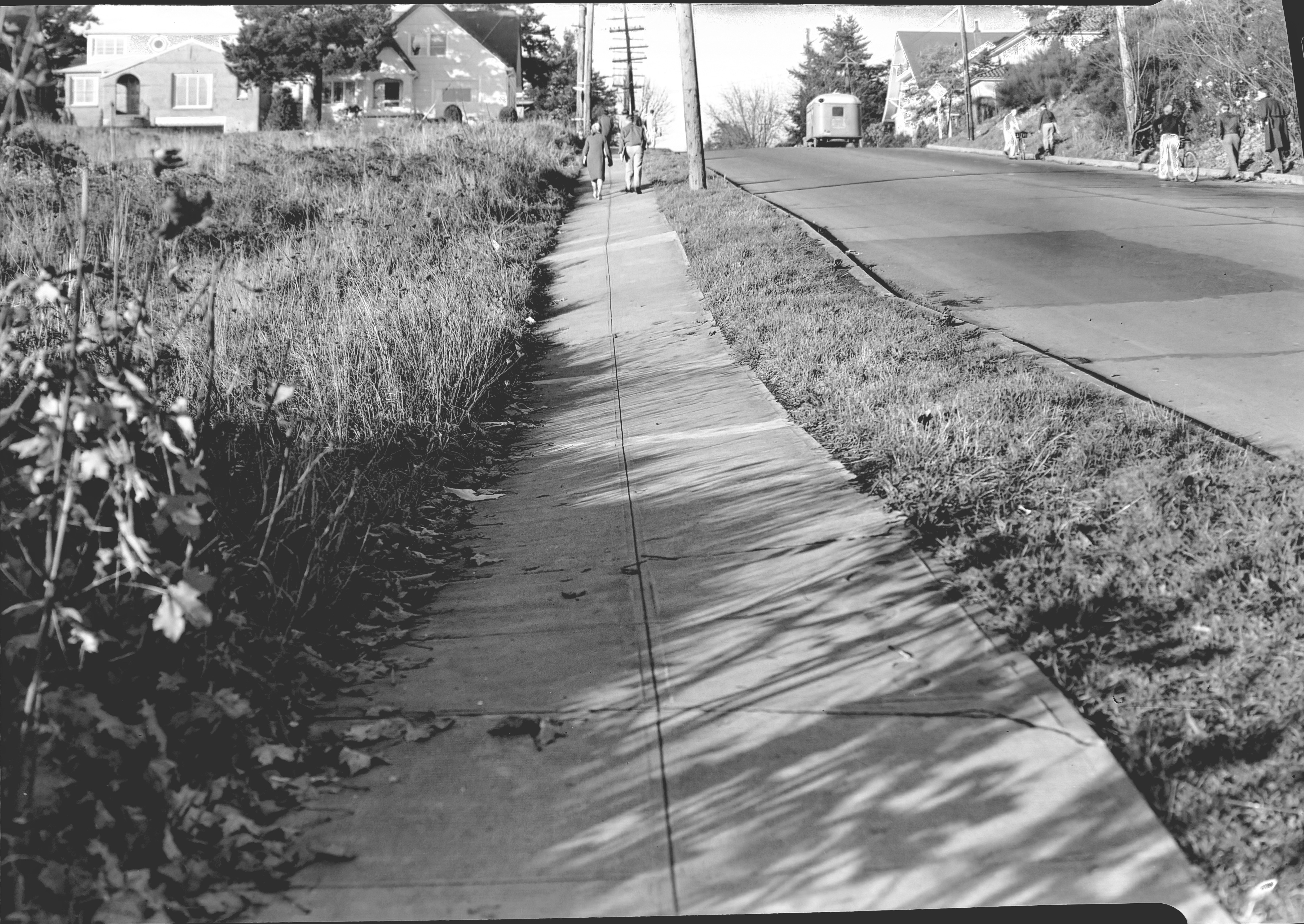
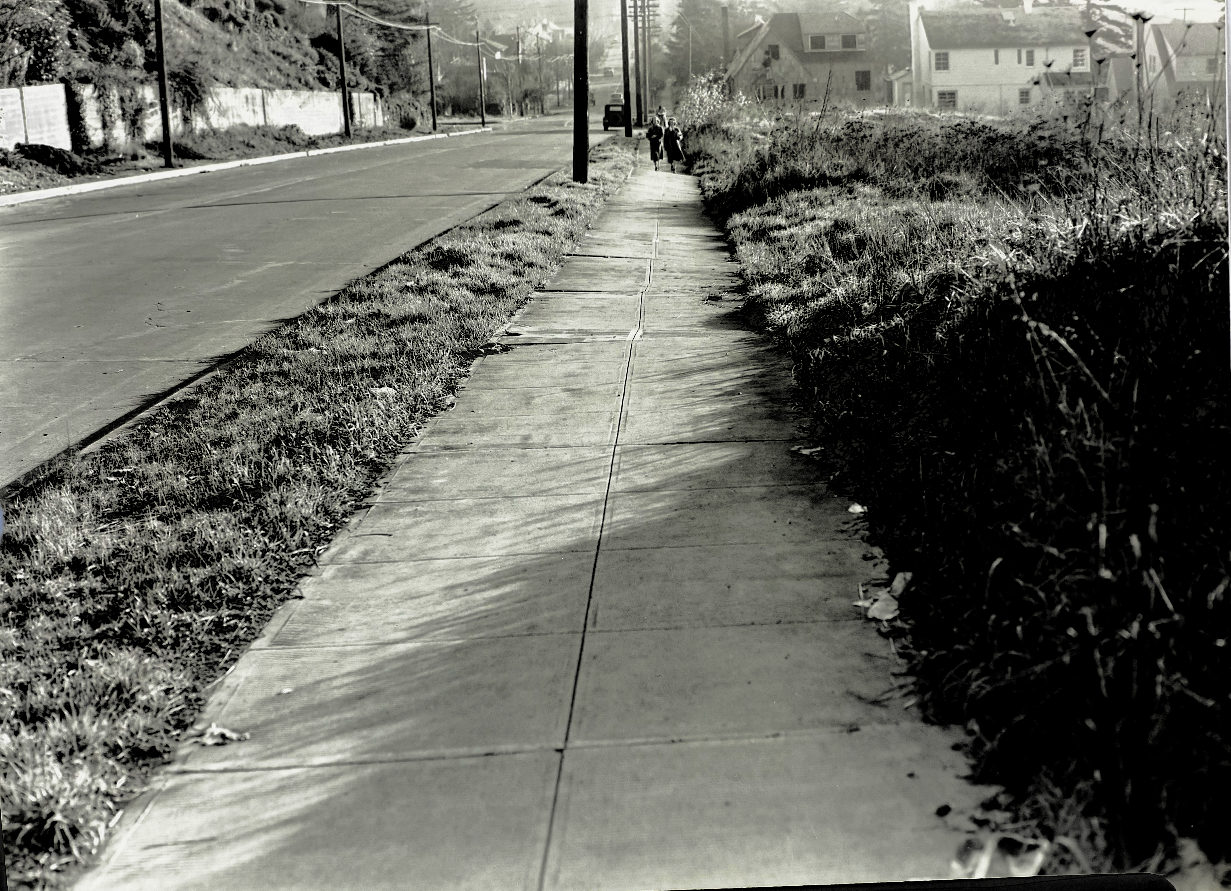
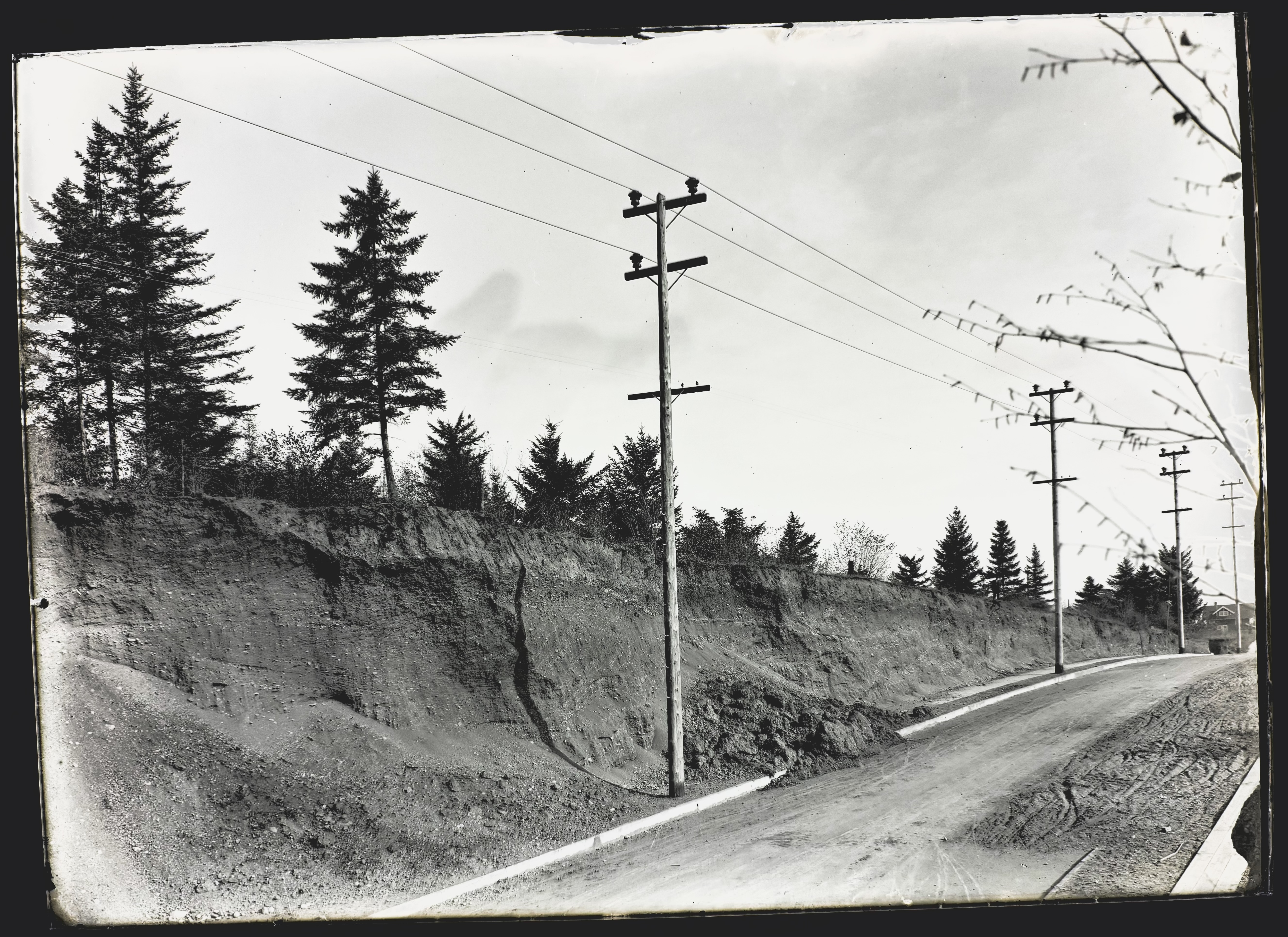
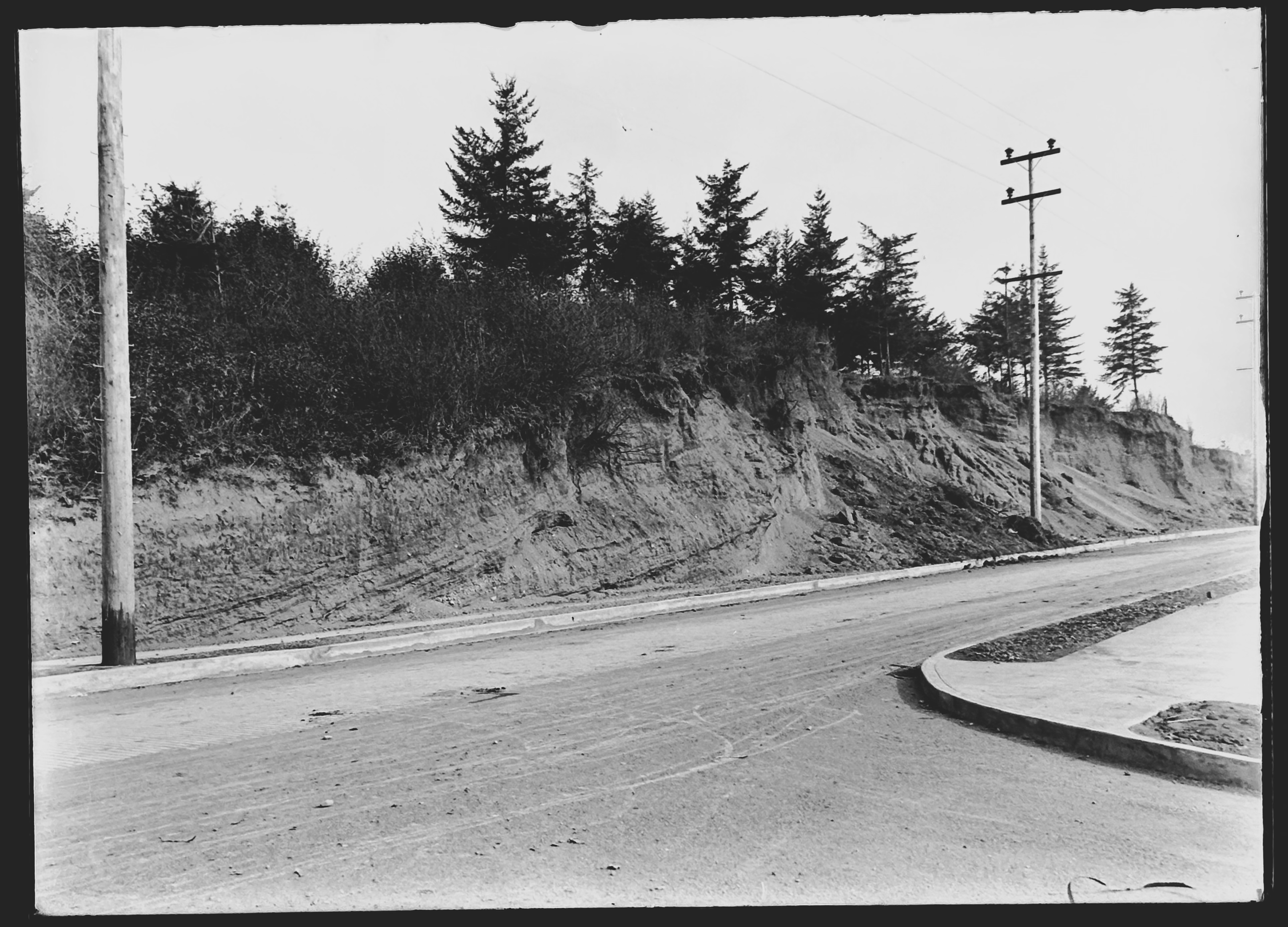
Here are two more views of the general vicinity taken 25 years later that show us how the slope was settling after being filled with garbage and soil. Photographed by the Public Works Department on November 21, 1938, these views look uphill and downhill on 33rd from just below the top of the hill. Click in for a good look and then we’ll discuss:
Looking north along the west side of NE 33rd, just downslope from NE Fremont. Image A2009.009.1272, courtesy of City Archives.
Looking south along the west side of NE 33rd, just downslope from NE Fremont. Image A2009.009.1271, courtesy of City Archives.
Judging by the sunlight and shadows–and what looks like an exodus from Grant High School–these photos were taken in the afternoon of that November day. The uphill photo shows just how much the mid-slope has settled, with the curb and street surface buckling and the entire sidewalk heaving to the west. Nothing has been built on these vacant lots, probably because they were still settling.
Look a bit farther up the hill and you can see two brand-new Ken Birkemeier houses at far left (3279 NE Fremont), perched on what had been the cutbank, and the bungalow to its east at the corner (3289 NE Fremont). Across the street farther east you can see the high-peaked roof of the home at 3304 NE Alameda, and the distinctive tile roof of the Mediterranean-style house at 3301 NE Fremont.
Also interesting to note: no signal light controlling the intersection, nor is there a stop sign facing 33rd (can’t read what is on that sign, but it’s not the standard octagonal STOP sign we know today, which was in common use by 1938). Perhaps Fremont had the stop sign and 33rd had the right of way.
Yet to be built at the top of the hill on the southwest corner was a mid-century home and swimming pool that would eventually collapse into the old pit area and be replaced in the 1990s by a much larger house (and geotechnical engineering). We wrote about it here: The lost house at 33rd and Fremont.
The downhill photo looking south shows just how much the sidewalk wants to fall off into the old pit. Below the pedestrians you can see a house under construction–3289 NE Klickitat, also by Ken Birkemeier who was very busy in this part of the neighborhood during those years.
Today we have Google streetview to document so many aspects of our neighborhood, but it’s been a treat to turn back the clock with these and the 1913 photos. We’re always on the lookout for early photos of our Northeast neighborhoods. Stay tuned for more findings. The promised Columbia Slough photo from 1913 is next.
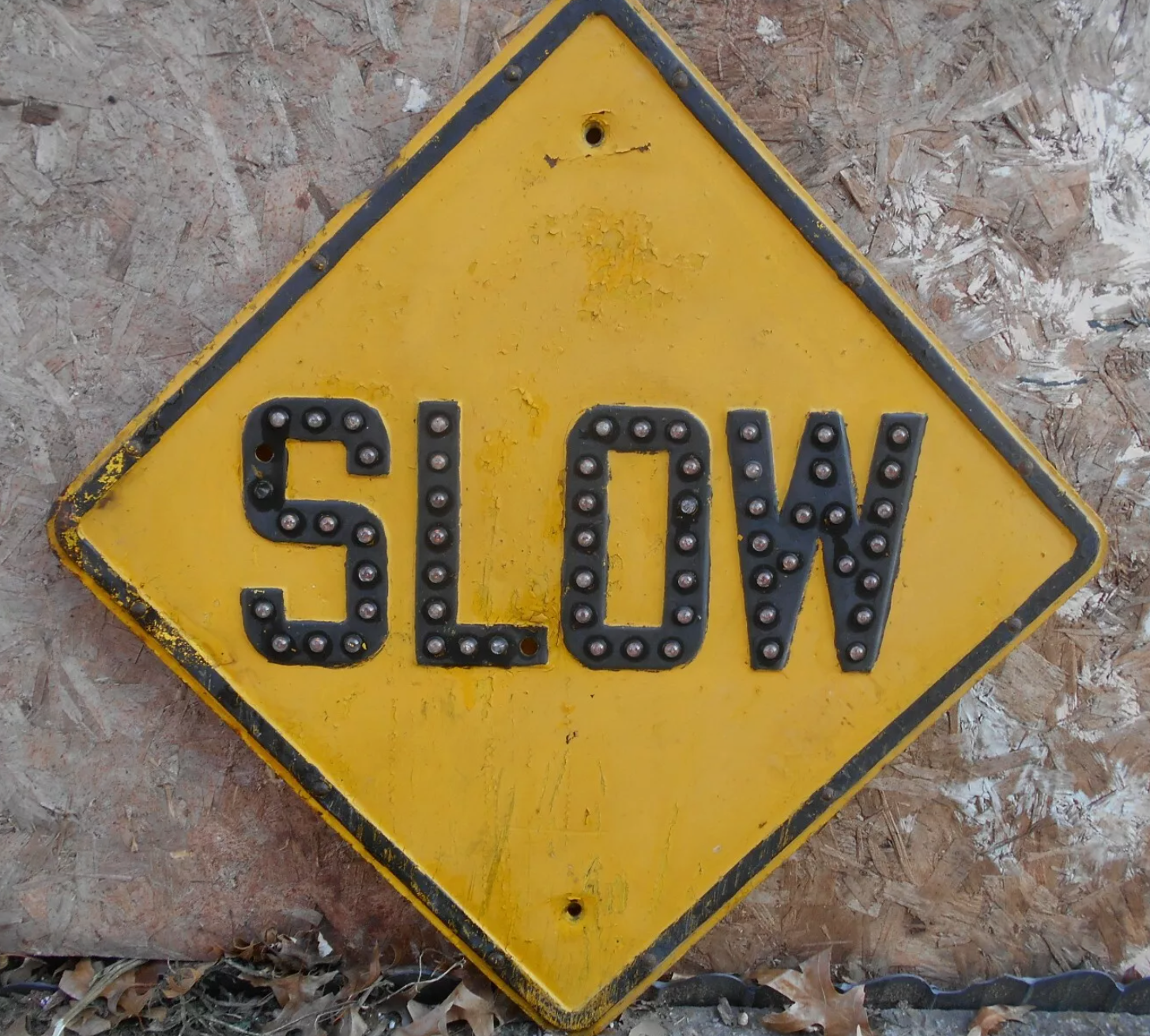
Post Script:AttentiveReader John Golightly adds his observations that the sign at the intersection probably was a “SLOW” sign, which we agree with. Here’s a photo of a 1930s-era slow sign in its characteristic diamond shape:
In 1913, nearby property owners and the Department of Public Works were concerned about the stability of the slope above Fremont Street in the stretch between NE 30th and NE 33rd. Fremont itself was perched along the north edge of a giant gravel pit that had been mined for decades and would eventually be filled with garbage to build it back up to grade.
NE Fremont Street looking east near today’s 32nd Place, in 1913. Click in for a closer look. Gravel pit to the right (south) and cutbank above to the left (north). House in the center is 3415 NE Fremont. In the distance, sewer pipe is stacked down the hill along the east side of 33rd and a person faces the photographer at the intersection. A wooden plank sidewalk runs along the south side of Fremont. The gravel and dirt streets were paved the following year. Photo courtesy of City Archives, A2009.009.3615.
The cutbank slope above Fremont angled up 50-75 feet to the southern edges of the brand-new Alameda Park and Olmsted Park subdivisions, which flattened out to the north atop Alameda Ridge. With nothing to hold the cutbank in place, dirt and gravel would periodically slide down, covering sidewalks and curbs and spilling out onto Fremont Street.
A Department of Public Works photographer was there to document the slope. These are the last three in the series we’ve been sharing of re-discovered images at City Archives that are labeled as “Lombard Street.”
Moving farther west on Fremont, the photographer noted two other slides that had covered sidewalks and curbs.
NE Fremont Street. Looking east just below the crest of Alameda Ridge, seen from between today’s NE 32nd and NE 31st. Photo courtesy of City Archives, A2009.009.3616.
Fremont Street running left and right, seen from the corner of NE 31st, which leads downhill at bottom right. Looking northeast toward the top of Alameda Ridge. Photo courtesy of City Archives, A2009.009.3618.
Be sure to take a look at this view as well, a low-elevation oblique photo from 1930 that shows the cutbank, the slope below Fremont (now filled with garbage and grown over with brush) and lots of other neat things to look at.
No big surprise both slopes were on the move. Geologists remind us Alameda Ridge is basically a giant gravel bar, deposited more than 15,000 years ago by the great Missoula floods that shaped our region. In the years after these photos were taken, vegetation returned to the cutbank slope and houses (and stairways) were built, increasing the surface stability.
Attentive reader and friend of Alameda Brian Rooney tracked down a great graphic that shows the east-west pendant gravel bar of Alameda Ridge that formed downstream (west) of Rocky Butte during the great floods. Helps visualize the old “Gravelly Hill” ridgeline. The arrow points out the intersection of 33rd and Fremont:
A detail from a comprehensive poster explaining the Missoula Floods by the Oregon Department of Geology and Mineral Industries. Thanks Brian!
Up Next – A bonus photo from Public Works: the Columbia Slough in 1913.
Every now and then in my research, I’ll find something—a memory, photograph, map or document—that really sticks with me and defines the way I think about a place.
This month I found a batch of mis-identified photographs when searching at City of Portland Archives that resulted in an absolute jackpot from 1913, opening a fresh window into the past near NE 33rd and Fremont.
Once known as Gravelly Hill, the area was indeed a gravel pit for many years in the late 1800s, and later the repository for all of the eastside’s household garbage between 1923-1924, then known as the Fremont Sanitary Landfill.
But before the landfill, back in 1910 as subdivisions crowded in around the big pit, questions were raised about the basic stability of Fremont Street, which was just below the brow of the Alameda ridge and ran right along the north edge of the pit. Developer Benjamin Lombard, who platted the adjacent Olmsted Park about that time, even sued the city for violating its own ordinance about gravel pits.
So, no secret: that slope South of Fremont was a gravel pit.
But as it turns out, it wasn’t just a gravel pit. It was a GIANT gravel pit. See for yourself:
You’ll want to click into this for a good look. Looking east along Fremont toward NE 33rd from about today’s NE 32nd Avenue. Sewer pipe stacked along the eastern edge of NE 33rd, which slopes downhill left to right. The roof of the house visible at treeline in the center is the Barnes Mansion, 3533 NE Klickitat, which was then brand new. City Archives Photo: A2009.009-3611 (mislabeled as Lombard Street)
In 1913, a photographer for the Department of Public Works visited the pit and brought back 11 amazing images that got buried in the archives. They’re large-format glass plate negatives, not prints, and for years have been filed away in envelopes under “Lombard Street” at City Archives. I suspect few people have ever seen them. A few weeks back, something else I was looking for led me to these glass negatives.
I photographed each plate and made positive prints to be able to better visualize the scenes. And as I studied that first picture and figured out it wasn’t showing Lombard Street, but Fremont Street, I knew this would be a find to remember.
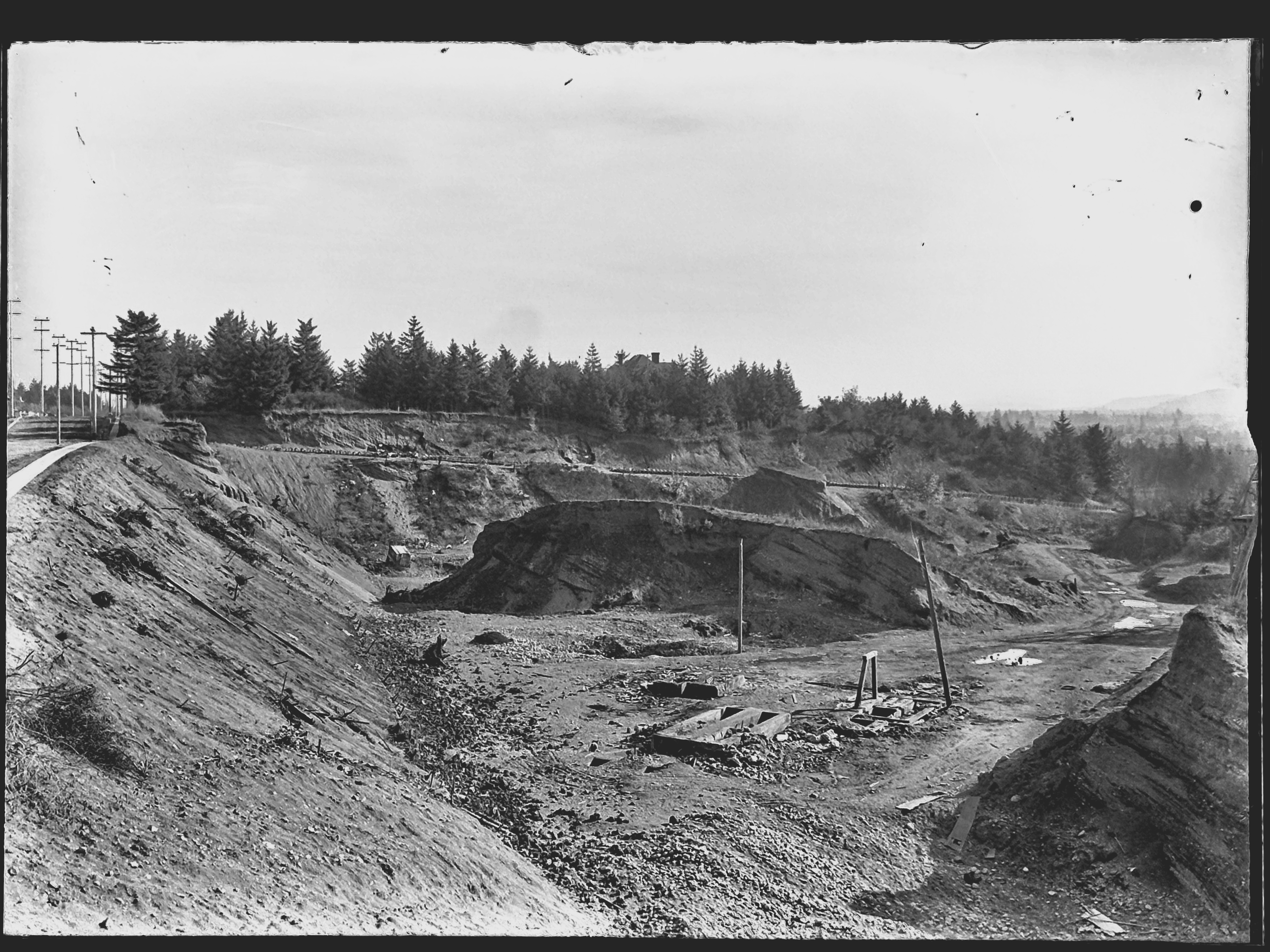
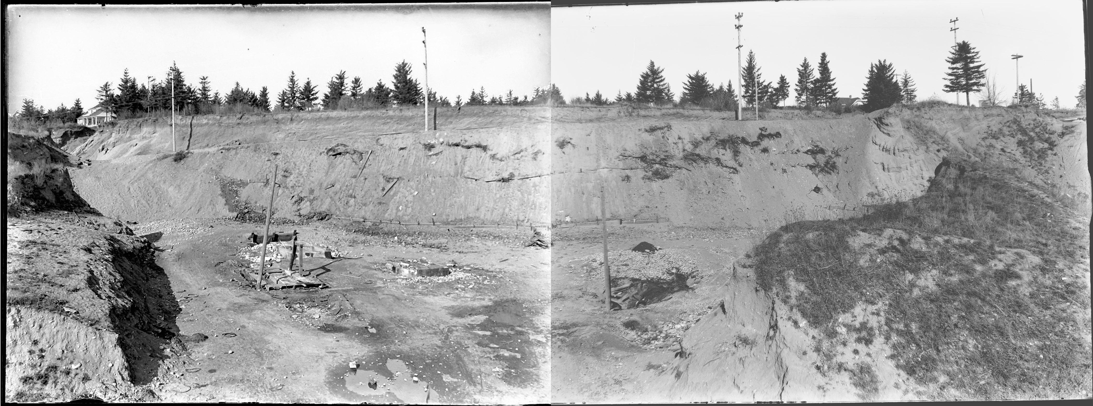
After that first photo, there were these next two, clearly taken as a pair, to illustrate the depth and breadth of the pit. Both are unquestionably tied to the Gravelly Hill landscape. Here I’ve melded them together to create a single image:
Looking north into the gravel pit at NE 33rd and Fremont, December 1913. Click to enlarge. View would be from between today’s Siskiyou and Klickitat streets, looking uphill. The house at far left is today’s 3251 NE Alameda Terrace. The house at far right is the top of today’s 3305 NE Alameda. A sign is visible at upper right for a new subdivision, placed in the cutbank on the northeast corner of 33rd and Fremont. Segments of sewer pipe are visible stacked there. Today, the pit is filled with three city blocks and more than 50 homes. City archives photos, left: A2009.009.3619; right: A2009.009.3620.
Here’s a bit more context from neighborhood historian R.A. Paulson, writing in The Community Press on October 1, 1975:
“From the earliest recollections of those familiar with the area, this was a worked out gravel pit, the excavation of which had been finished many years before but still showing the signs of one-time activity. As late as 1919 and 1920, the pit formed a precipice going down sharply from near Fremont possibly 100 feet or so to the level of Klickitat and extending between 32nd place and 33rd Ave. Coming from the west, Kllickitat Street was unpaved east of about 29th with the cement sidewalks ending there but even between 26th and 29th these sidewalks were impassable because of the overgrown bushes and small trees.
“The gravel pit had been a lush source of rock and gravel for someone way back and the solid bank of this material had originally sloped down from Fremont at the same grade as the present 33rd Ave. This had been scooped out over a period of perhaps 50 years or more and most likely went into improving the lanes, roadways and public highways for miles around, certainly for the country roads that became 33rd Ave. and Fremont Street.
“The bed of the pit showed evidence that work and even habitation had gone on there but at the time of World War 1, only a monolith of stone, too difficult to remove with pick and shovel, reared upward from the new level.”
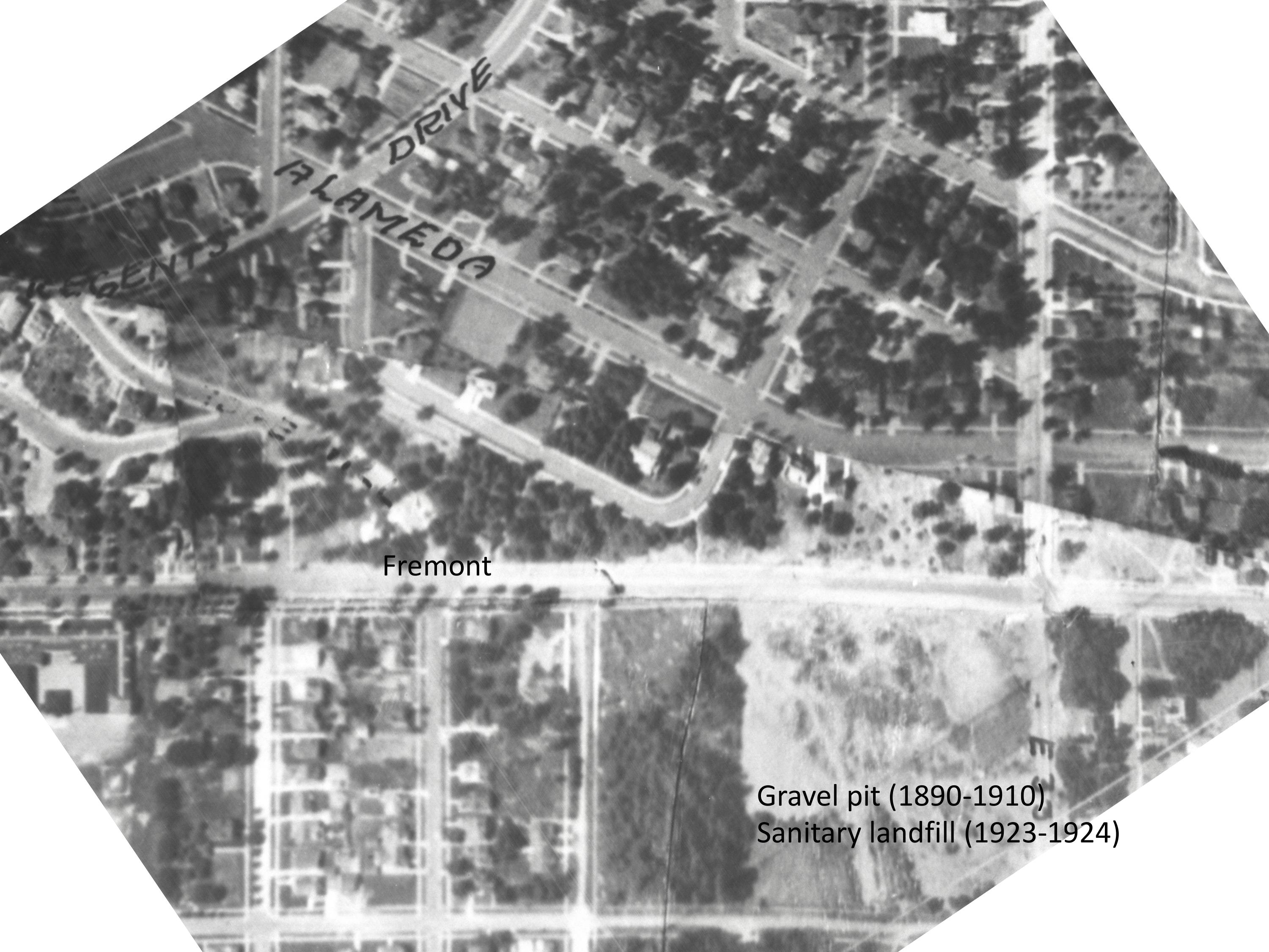
Here’s a detail from a 1925 aerial photo that shows the extent of the pit and the still-forming street infrastructure. The pit covered two-plus blocks, from NE 33rd to NE 31st, between Fremont and Klickitat.
Detail from a 1925 aerial photo showing the intersection of Fremont and 33rd, labels added for reference. Dashed lines indicate eventual location of NE 32nd Place and NE 32nd Avenue. Click to enlarge. Aerial photo courtesy of City of Portland Archives.
Stay tuned for eight other gems in this collection that are just as knock-your-socks-off amazing as these three. Next up: we’ll take a close look at the intersection of NE 33rd and Fremont 111 years ago, absolutely recognizable to today’s eye.
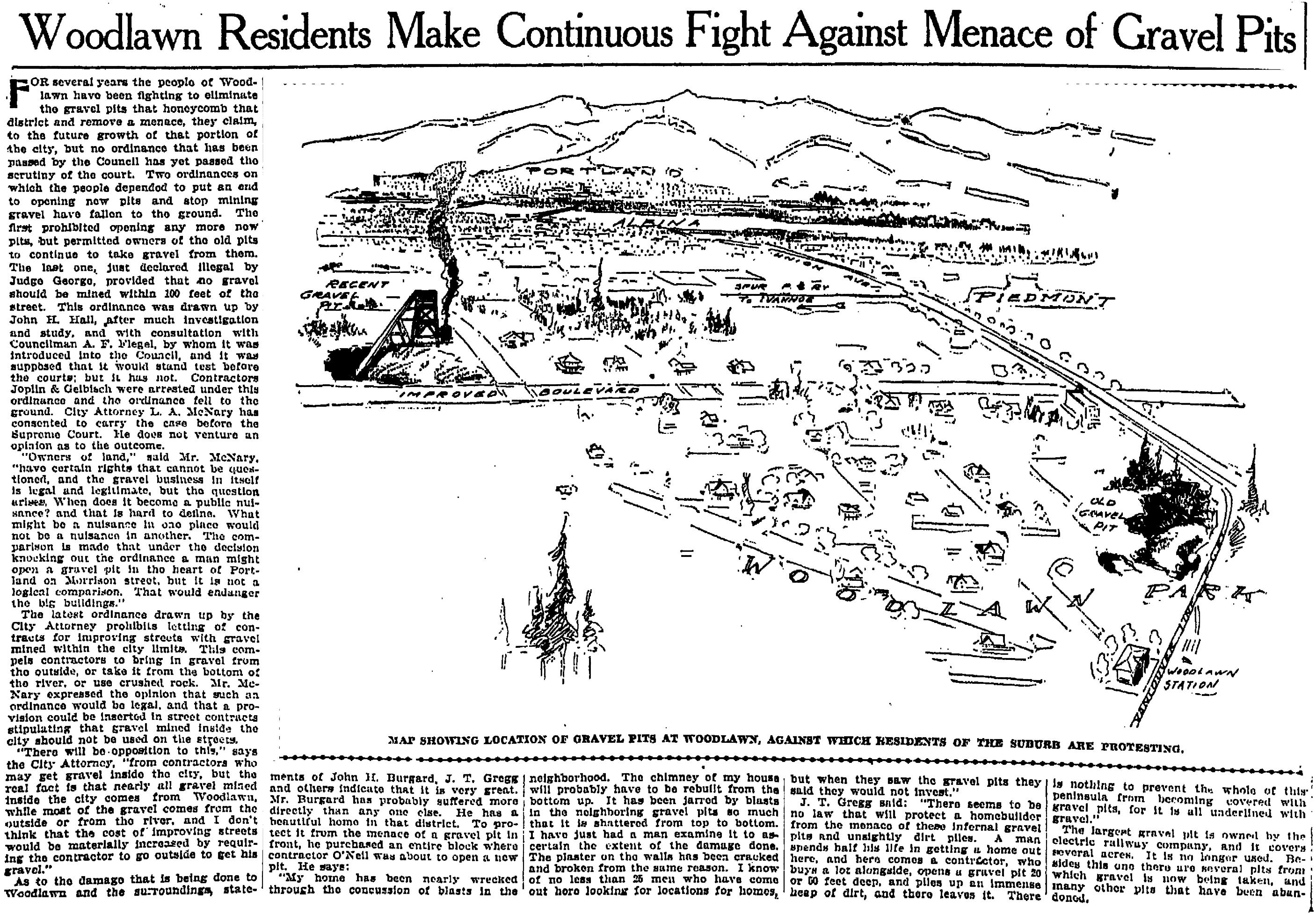
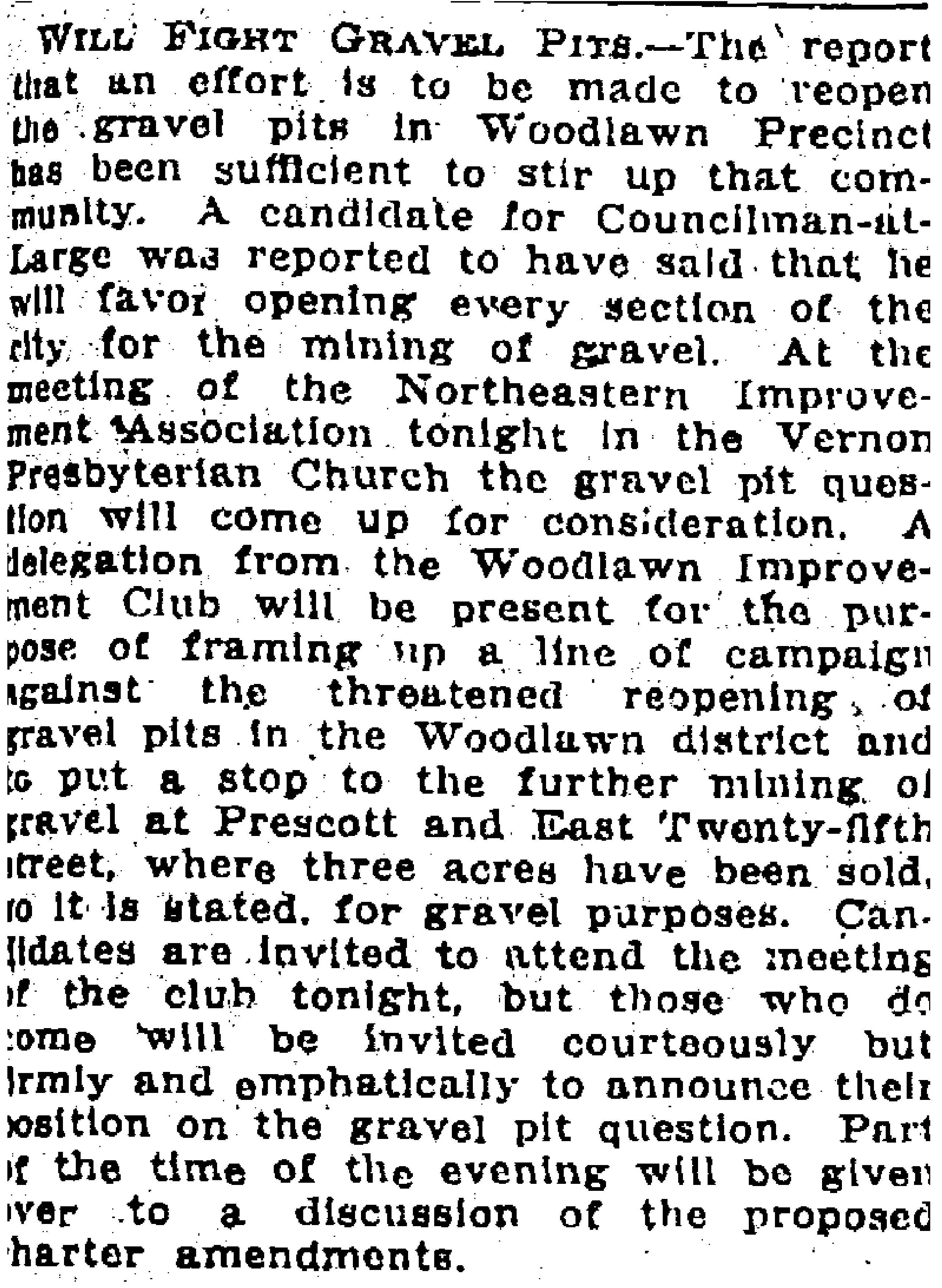
Since we seem to be on the subject of gravel pits and how neighbors feel about them, we thought this article from April 9, 1905 would be topical, and might even make some readers want to go for a walk with this 114-year-old sketch in hand to look for clues. Click into the story and you’ll find an interesting review of the city’s ordinances related to gravel; insight that most gravel mined from within the city limits came from Woodlawn; and what it felt like to live near a pit.
From The Oregonian, April 9, 1905. Click to enlarge.
Because the two primary sources quoted in the article describe impacts to their homes, it’s helpful to know that John H. Burgard lived at 833 NE Ainsworth (he went on to become the influential chair of the Commission on Public Docks); and J.T. Gregg lived a few blocks north at 6547 NE 8th Avenue.
Subsequent news stories reported the big pit—the one labeled “recent gravel pit” in the 1905 sketch and shown next to a conveyor belt and smoke plume (issuing from what looks to us like a steam donkey) on the left side of the sketch—was located between NE Martin Luther King Jr. Boulevard and NE 8th Avenue, south of Dekum and north of Ainsworth.
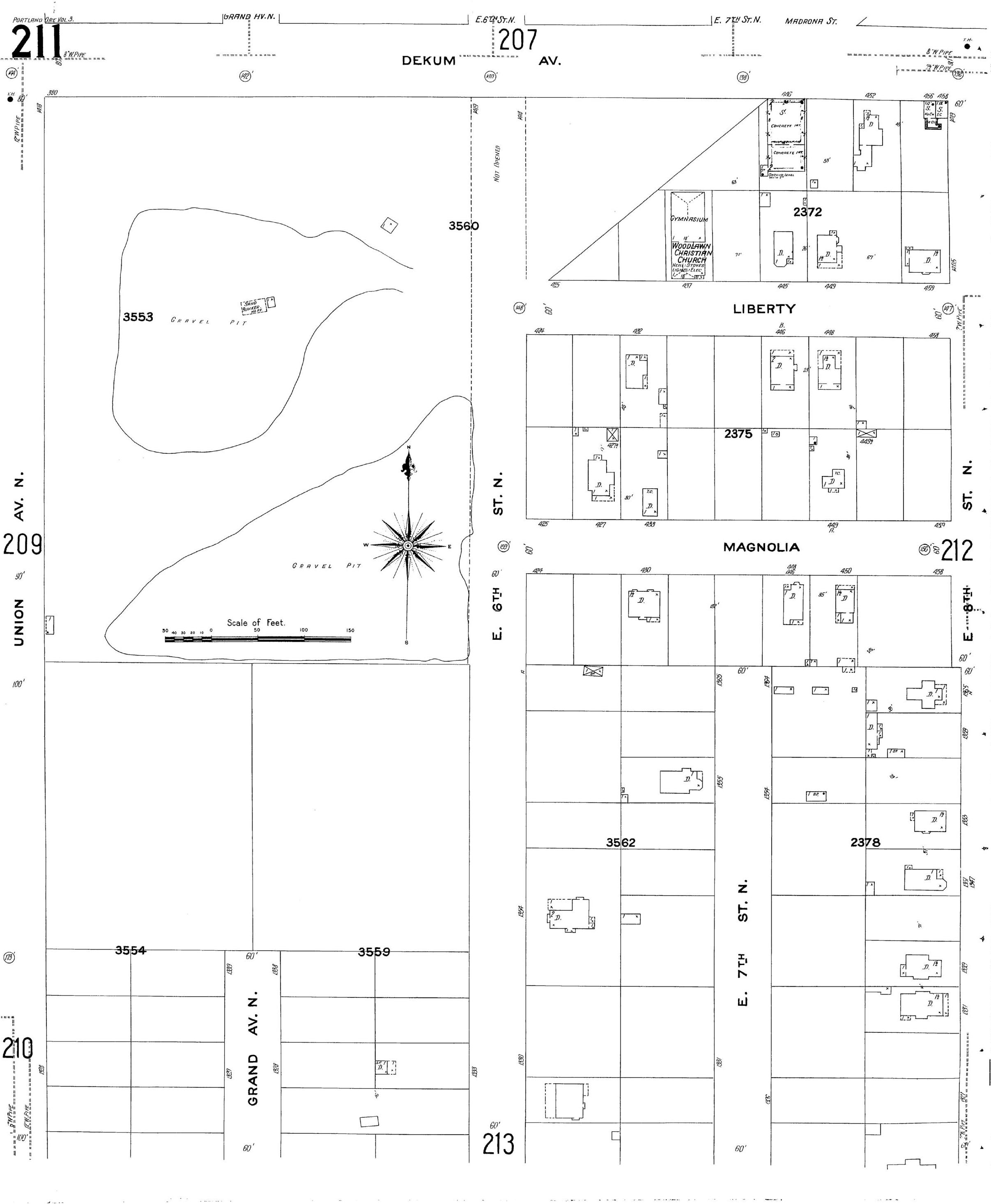
Here’s a look at the Sanborn Fire Insurance map of the area from 1908-1909. Magnolia on that map is today’s Rosa Parks Way. Another deep gravel pit existed about two blocks south of the big pit, just off this plate.
Sanborn Fire Insurance Map, Plate 211, 1908-1909
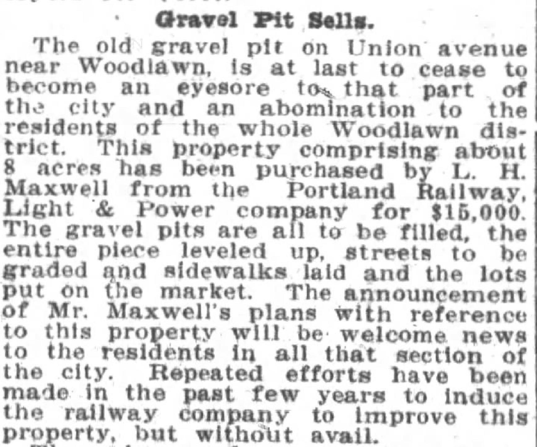
Fortunately for Woodlawn residents, the heated-up real estate market meant the property would be more valuable as a neighborhood than a gravel pit. In 1908, the pit area was sold to real estate developers W.C. North and L.H. Maxwell who proceeded with fill operations. The land was level by 1912.
From The Oregon Journal, January 17, 1909
Like their Woodlawn neighbors, Vernon residents were also on the defense when it came to gravel pits. Two years later, they were pressing city council candidates for their views about the troublesome three-acre gravel pit that used to be near the corner of NE 25th and Prescott.
From The Oregonian, April 30, 1907
One message from this new awareness about big holes in the relatively flat neighborhoods we know today is that there used to be a lot more topography out here. Check out the post we did a few years back about the big natural gulches that once marked the east side. Like Alameda’s own Fremont Sanitary Landfill, a lot of these gullies were filled with garbage, construction debris and worse.
Makes you appreciate the lay of the land we know today, and wonder what’s below the surface.
Over the years, we’ve heard the notion that there was once a gravel pit and then a garbage dump at the corner of NE 33rd and Fremont. We remember in the 1990s when the house at the southwest corner—the one with the old swimming pool out back—was removed because of major foundation problems, which seems like reasonable evidence of the underlying problem.
But we wanted to know more, so we tracked down the details. Let’s start with a photo to put you in context.
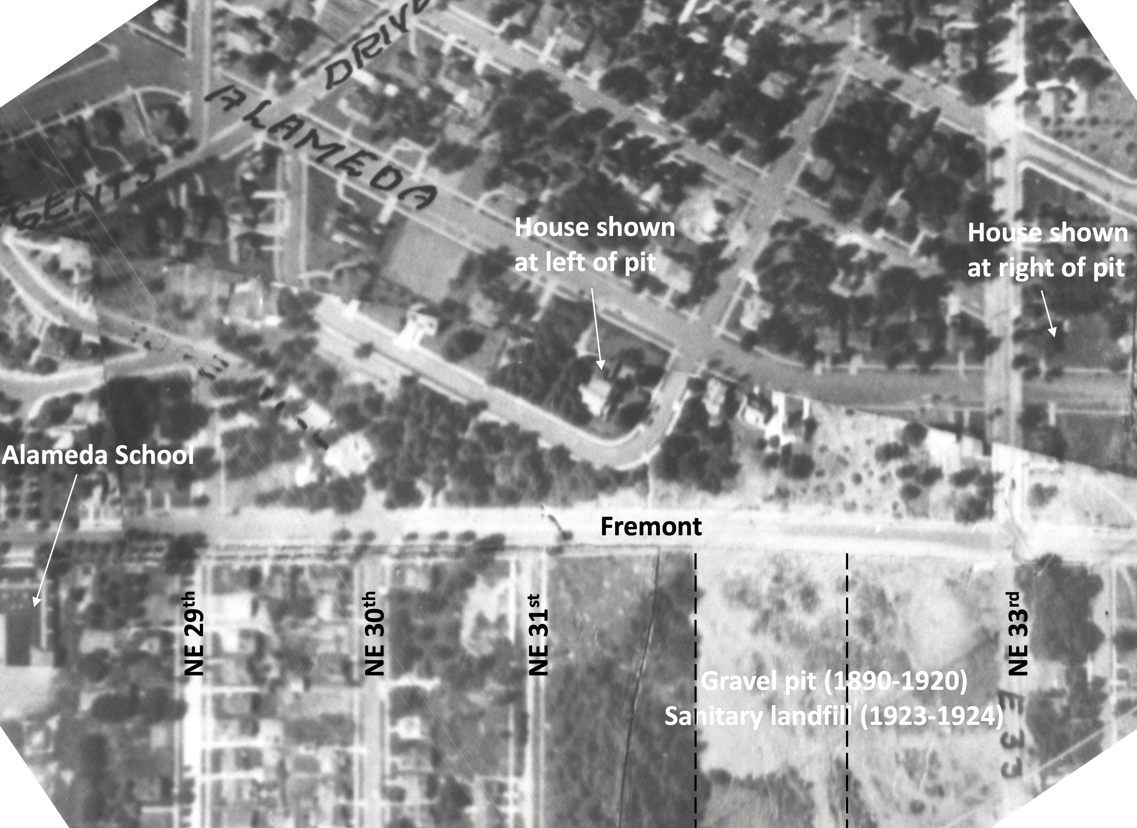
Here is the area in a 1925 aerial photo, the earliest one we know of. There’s lots to look at here, but start at the large vacant lot in the lower right hand corner. The street running east-west is Fremont and the vacant lot just below it to the south is actually three blocks, between today’s NE 32nd Avenue on the left and “E 33rd” on the right. 32nd Place (then known as Glenn Avenue before the Great Renumbering) does not yet go through.
Detail from a 1925 aerial photo showing the intersection of Fremont and 33rd, two labels added for reference. Click to enlarge. Aerial photo courtesy of City of Portland Archives.
That’s a pretty steep slope to the south (just ask local kids with sleds hoping for snowfall) which is one reason it’s one of the few unbuilt pieces of ground you can see in this photo.
Be sure to check out these historic photos of the area discovered in 2024 and depicting the pit in 1913.
Back in the late 1890s and up until about 1910, that slope was heavily excavated for gravel, which makes sense. It’s right along the crest of the Alameda Ridge, which after all is one giant gravel deposit left over from the cataclysmic Lake Missoula Floods of 13,000-15,000 years ago. The Fremont gravel pit provided tons of rock for a young and growing Portland, which was busy building roads. In those early years, 33rd and Fremont even became known as Gravelly Hill, a name that stuck around for decades (we try to slip that name into a conversation whenever we can, you should try it just to keep it alive).
In the photo, you can see the disturbed area at the top of the slope all along the southern edge of Fremont. That was the top of the gravel pit. A few years later it was also the top of the garbage dump.
In 1910, Benjamin Lombard, who developed the Olmsted Park plat which you can see just up the hill in this photo (now considered part of the Alameda neighborhood), sued the city for violating its own ordinance that prohibited gravel pits within 100 feet of a public street. Fremont was a city-owned street, plus the city owned a good chunk (but not all) of that vacant lot to the south too. East 33rd had long been known simply as the County Road and was the county’s responsibility.
A letter to county commissioners in August 1910 reported “the roadway at Thirty-third and Fremont streets is in danger of caving in because of excavation in the Fremont gravel pit.” The county passed this complaint along to the city, which was also hearing from Lombard about the same time. Due to the undercutting of the slope required by the gravel mining operations, Fremont Street was just about ready to slide down the hill.
This 1910 kerfuffle ended the slope’s official function as a gravel pit, though other places—notably a nearby hollow on privately owned land at the corner of today’s NE 37th and Klickitat—stepped in to meet the gravel need.
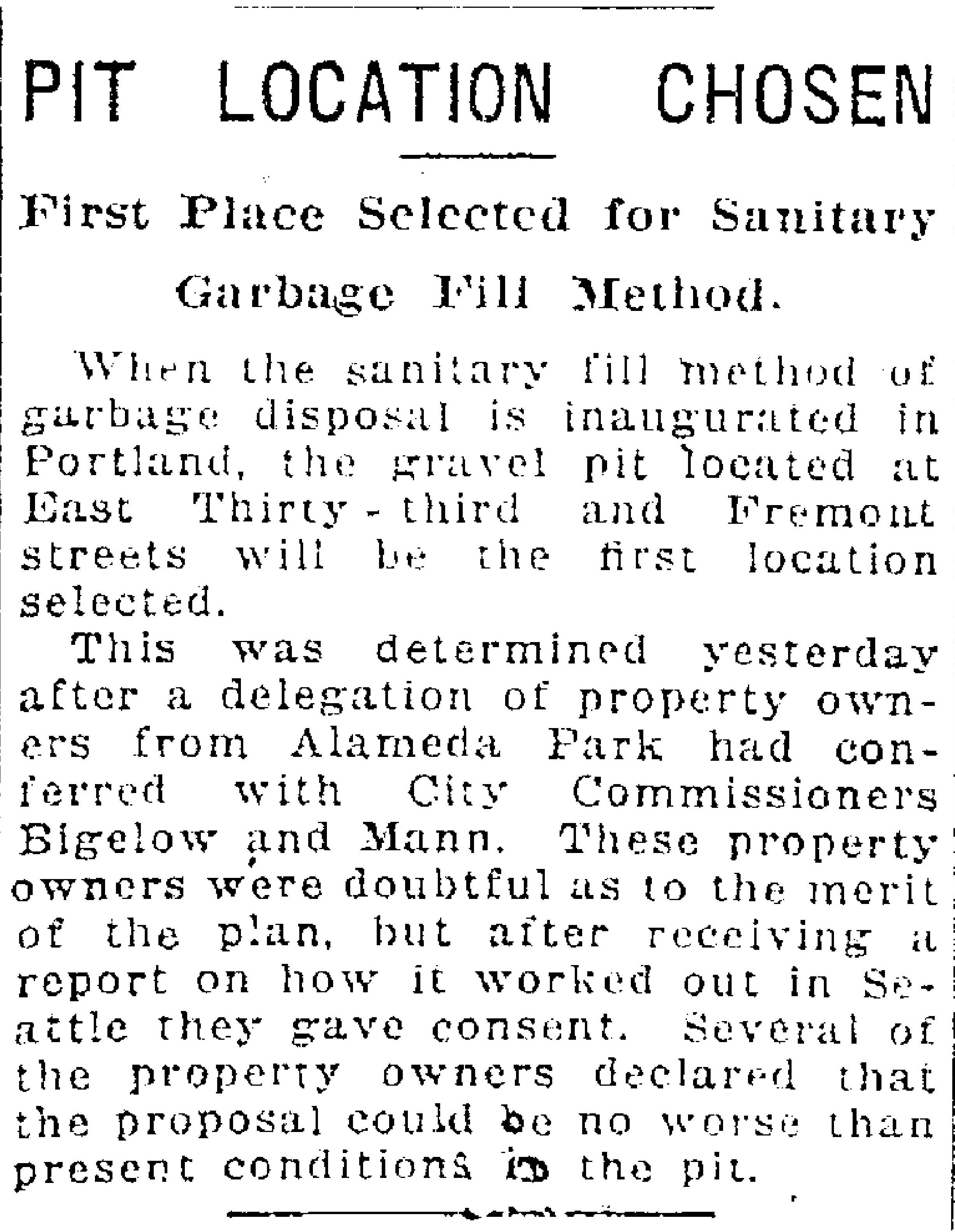
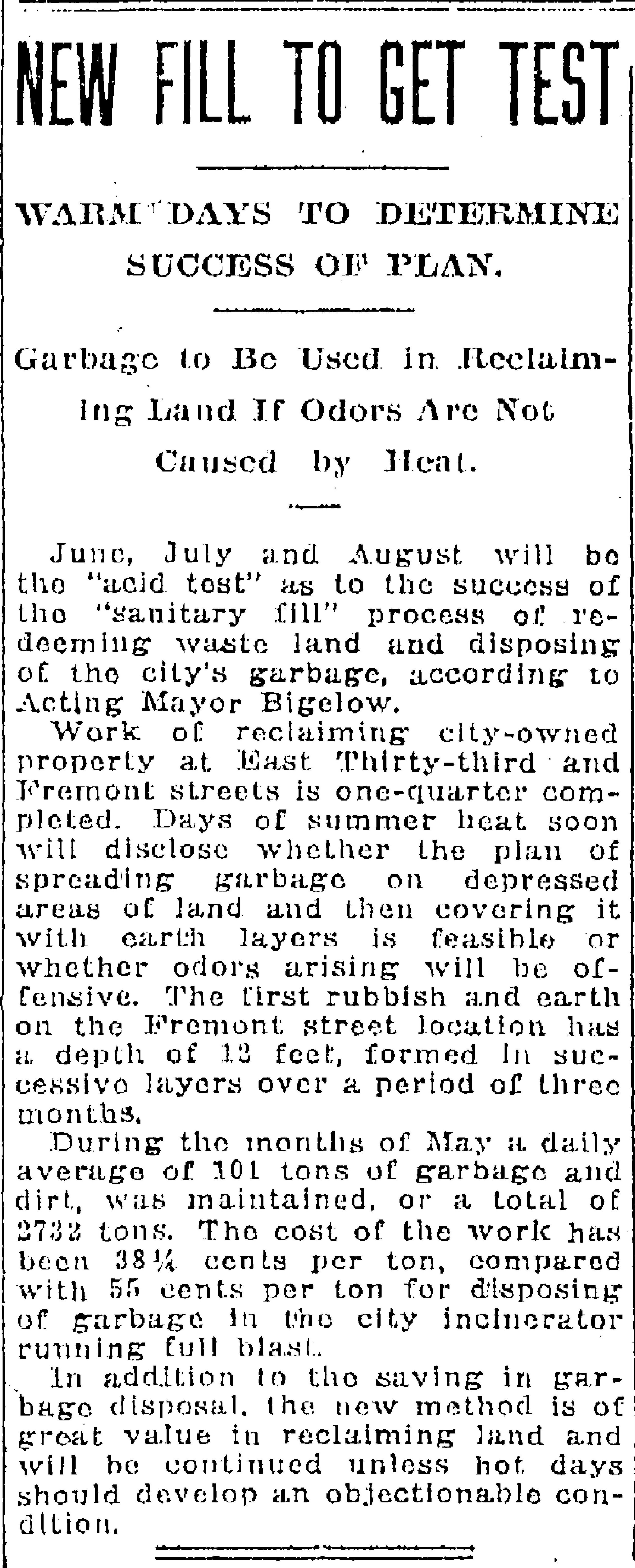
Fast forward to the early 1920s. Portland was booming and rapidly running into a garbage disposal problem. The city’s Guilds Lake Incinerator, located in Northwest Portland at NW 25th and Nicolai, was operating at full capacity and the city needed to find another way to deal with garbage.
William G. Helber, Portland’s Superintendent of Garbage Disposal, had visited Seattle and seen a new technique called “sanitary fill,” whereby garbage was mixed with dirt and buried in layers on uneven ground. This had the double “benefit” of disposing of garbage and leveling off land that could then be used or sold for other uses.
When Helber looked out across the Portland landscape, he fixed on several locations he believed would function well as sanitary fills.
From The Oregonian, January 16, 1923
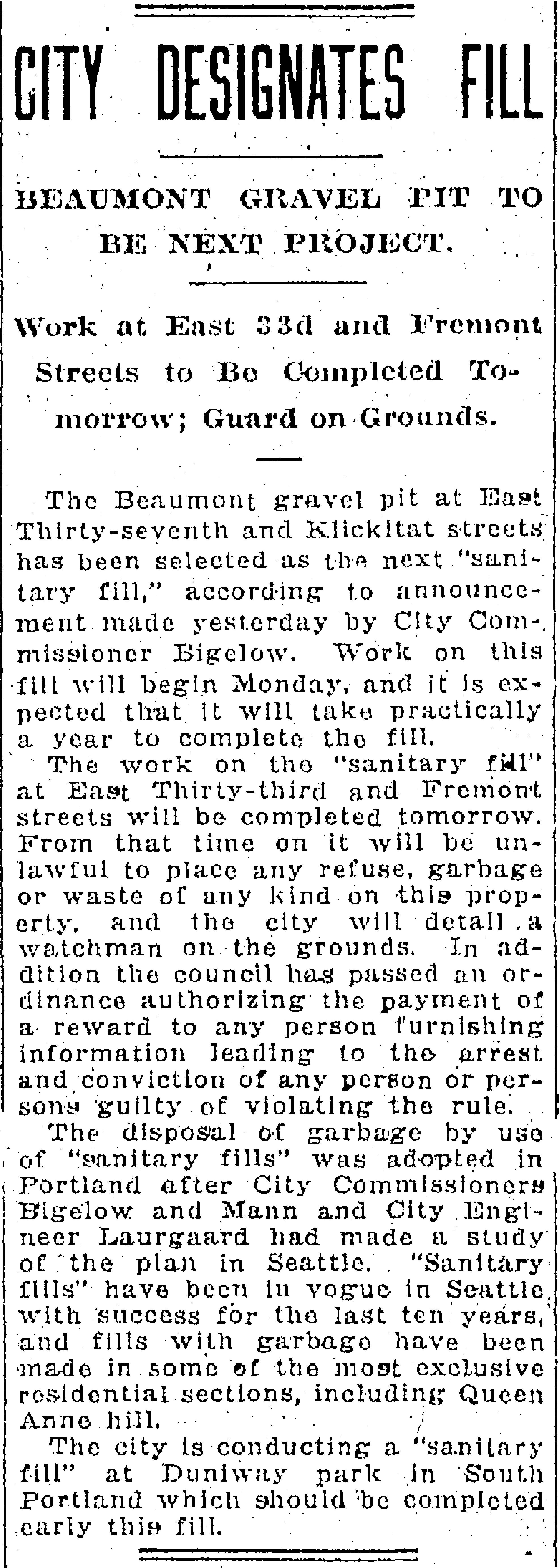
Because the city didn’t own the downslope part of the hill, it took some creative deal making with the adjacent private owner to make it all work. Downslope owners Joe and Frances Brooks also owned the gravel pit at 37th and Klickitat. They agreed to let the city use the lower end of the Fremont pit for the garbage fill as long as the city would also fill up their old gravel pit on Klickitat with garbage. This site became known as the “Beaumont Fill.” The Brooks were then free to sell that as viable real estate to the developer who wanted to build houses there.
Not everyone was happy with the idea of burying garbage so close to existing homes. Alameda neighbors, who were always ready to protest (schools, camps, churches), were particularly skeptical. But Helber took them out on the ground to have a look at what he had in mind and the neighbors seemed satisfied to give it a try.
From The Oregonian, January 20, 1923
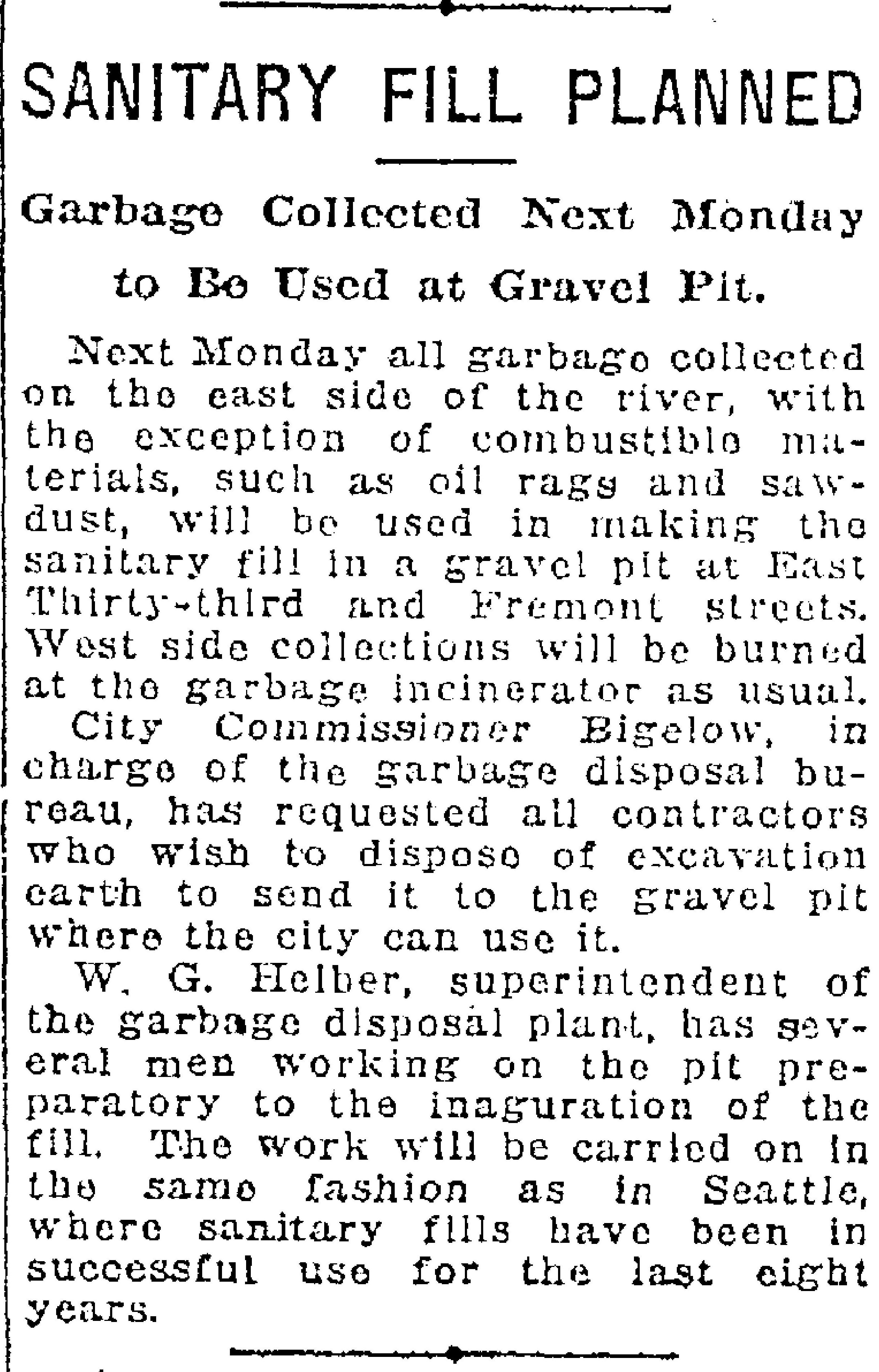
Starting in February 1923 through June 1924, all non-commercial trash from Portland’s eastside was hauled to Alameda to fill up the old Fremont gravel pit.
From The Oregonian, February 7, 1923
When the summer of 1923 rolled around, everyone held their breath (and their noses) wondering if the heat and the garbage would create a smelly problem. No news must have been good news, because there was no further coverage.
From The Oregonian, June 6, 1923
Here’s a great photo from the early 1930s that shows both of the completed sanitary fills (and so much else to look at). We love this photo.
Aerial oblique photo from the early 1930s shows both former fill sites and a lot more, including a very brushy Wilshire Park and the new Beaumont School. Click to enlarge this amazing photo.
In 1924, one year after opening when it became time to shut down the Fremont Sanitary Fill, the city realized it had trained all of east Portland to bring its trash to Alameda, and that it would probably take some retraining and even some enforcement to break the habit.
From The Oregonian, May 30, 1924
In a final accounting contained in his January 1926 report to City Commissioner Charles A. Bigelow, Garbage Disposal Bureau Director Helber summarized the following statistics for the Fremont Street Sanitary Fill:
Estimated number of loads of garbage received: 1,618
Average number of loads received per day: 62 ½
Average tons of garbage dumped each day: 136
Estimated tons of garbage dumped: 3,541 ½
Average yards of dirt received per day: 3 ½
Total salary of all dump workers per month: $442
Monthly installment on new tractor used on site: $121.25
That’s a lot of garbage. Sixty-two loads arriving at the top of the hill on Fremont Street each day for more than a year, dumped over the edge, spread by tractor down the slope and covered over with a little dirt.
The city continued to use the sanitary fill method in other areas as it planned a larger incinerator—a long drawn out process because no neighborhood wanted it in their backyard—which was ultimately built in 1932 in St. Johns and is known today as Chimney Park.
But in the meantime while incinerator planning and location were being fought about in City Hall, the fill method was gaining critics. Here’s news of neighbors at NE 37th and Alberta (today’s Alberta Court) complaining about the stench to City Council.
From The Oregonian, October 20, 1927
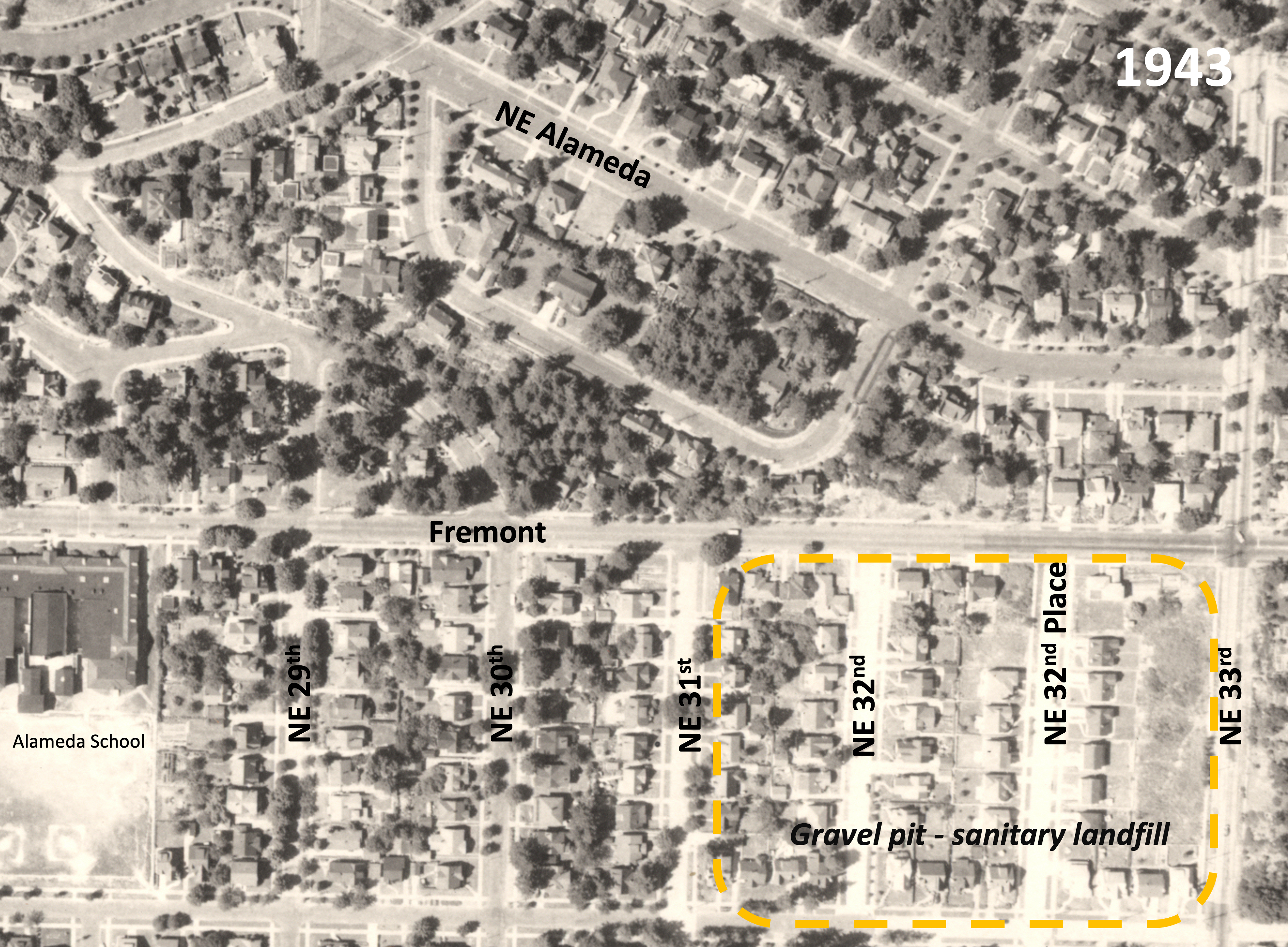
Back at the Fremont fill in the early 1940s, home construction was just getting underway. Here’s a photo from 1943.
Detail from a 1943 aerial photo, dashed orange added to show former gravel pit and fill area.