The thing about the Vernon tanks is that we see them so often they’ve somehow slipped from view.
Like wallpaper, we take their faded green bulk for granted. But when we pay attention, they loom large, visible from all corners of the neighborhood. Even arriving by air into the Portland area—remember flying on airplanes?—the tanks jump up out of the grid to announce the presence of the Vernon-Sabin-Alameda neighborhood, the start of the Alameda Ridge.
What if we looked at them in a new way with fresh eyes? Can you do that?
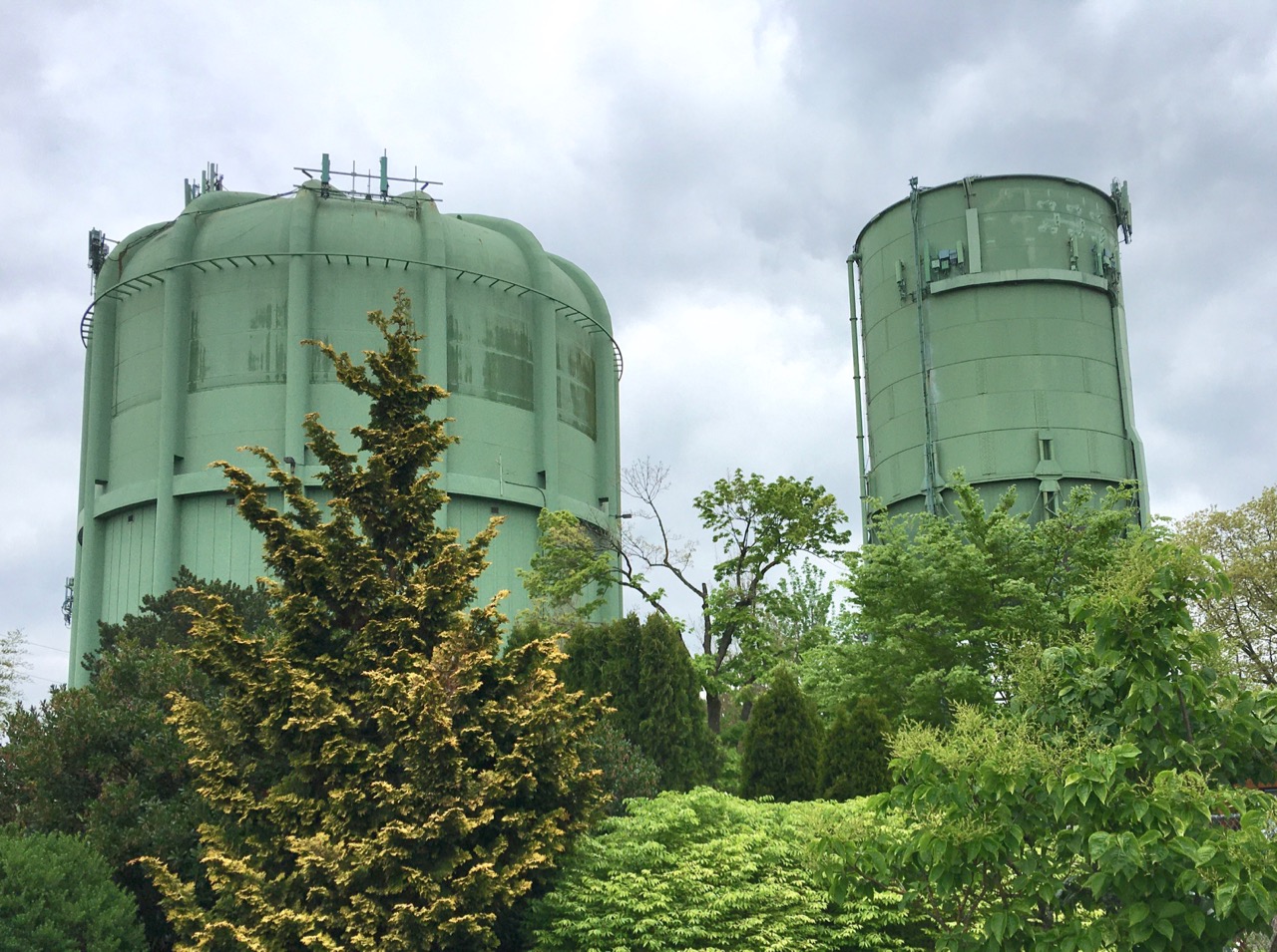
The Vernon Tanks, NE 19th and Prescott, April 21, 2020
The story of these tanks is a neighborhood story about water. A lot of water. Because it involves so much water and so much time, we should break it into a few parts:
In this first part we’ll describe the early days of Portland’s amazing water system and how it arrived in our neighborhood.
In the second part, we’ll describe the pivotal role this area played as a kind of water waypoint: how the city was able to get a lot more water here where it could pause for a bit before being moved farther out the line to other thirsty neighborhoods.
In the third part, we’ll focus on the water tank building effort that produced the green behemoth we know today.
In a post-script, we’ll have a look at a great photo from the big day the guys poured concrete in 1920.
To help tell these stories, we’ll share a bunch of 100-year-old photos that haven’t seen the light of day for decades, some 50-year-old negatives that don’t even have prints for them, and lots of news clippings that help us piece it all together. So, grab a glass of water and let’s go.
Watering the Grid
Fortunately for all of us in Portland, water runs downhill. Our abundant clean water starts in Bull Run on the forested slopes of Mt. Hood and through an engineering miracle beyond your wildest imagination courses through pipes and headgates, valves and meters all the way to your kitchen.
Back at the turn of the last century as eastside neighborhoods were just taking off, one of the many challenges of carving out the grid of streets had to do with getting city services in here. We’ve already written about the sewer system, which was available to most of our homes by 1914. But water was first.
Here’s a look at the neighborhood in 1909, thanks to Sanborn Fire Insurance maps. It’s an index of the many individual map pages (each big black number represents a more detailed map). Double click for a closer look.
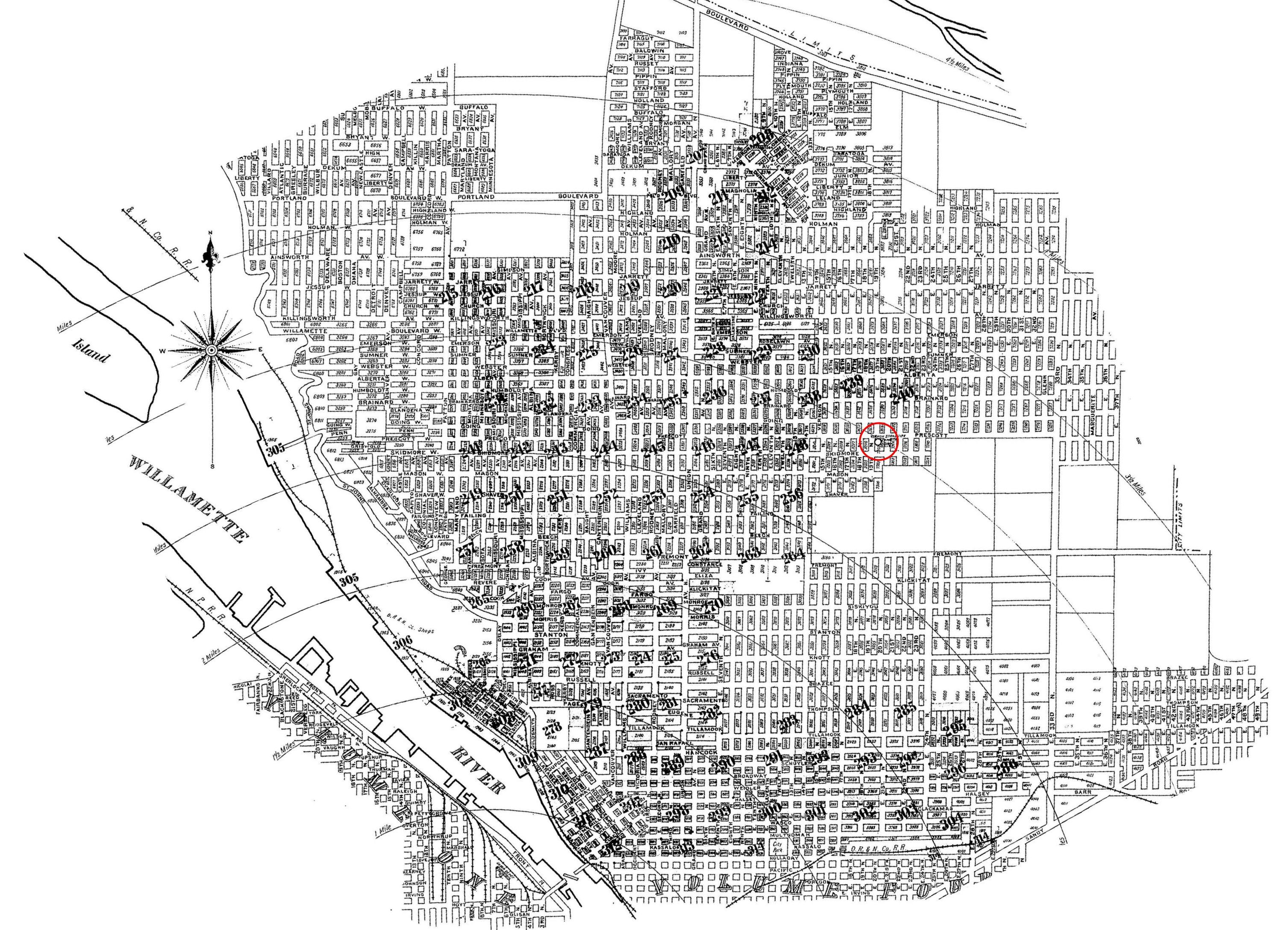
Note the city limits boundary just east of NE 33rd. Also note the open fields that were soon to be filled in by Alameda and Beaumont. When this map was drawn, this part of our city had been Portland for less than 20 years. Imagine the biggest subdivision you’ve ever seen rolling off east through the fields to the horizon.
Look carefully at the corner of NE 19th and Prescott (we’ve circled it in red). That’s the Vernon Standpipe, the earliest predecessor of the tanks standing there today, built and plumbed in 1906. Here’s what the Vernon Standpipe looked like in August 1920, courtesy of City of Portland Archives, A2008-009.
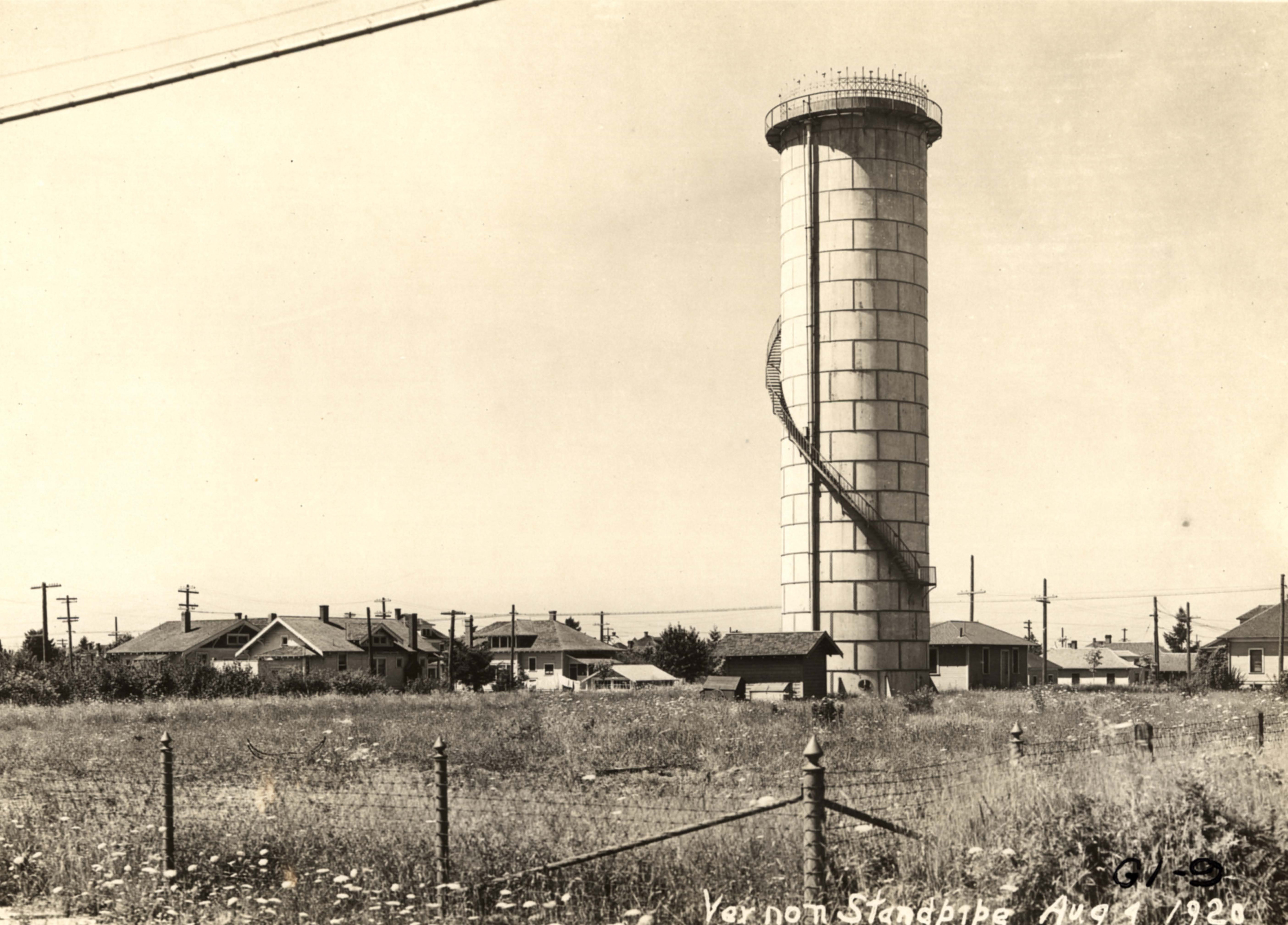
Looking southwest from Prescott and NE 20th.
A standpipe is basically a fancy name for a tank that is taller than it is wide and is used to create pressure down the line in the system, which is exactly what the neighborhood needed in its earliest days. Think of it as a miniature above-ground version of the Mt. Tabor Reservoirs, where water could be stored waiting for you to turn on your tap.
Water in the standpipe came from Mt. Tabor in an elaborate system of pipes. The problem was—as the grid spread out and more houses were built—the pipes were too small to carry enough water, the standpipe wasn’t big enough and couldn’t exert enough pressure, and people were running out of water.
That first standpipe was installed at NE 19th and Prescott because of its elevation on the ridge. It used to stand at the corner of NE 13th and Schuyler, but was shifted uphill in 1906 (at a cost of about $10,000) to get the extra pressure. Interestingly, it took the city nine more years to eventually sell the empty 100 x 100 lot on Schuyler for $4,500 after neighbors complained it had become an unsightly dumping ground.
By 1910, water engineers knew they needed to increase capacity to north and northeast Portland and by 1912 the Water Board had acquired adjacent property at 19th and Prescott for a more elaborate storage facility.
A water crisis in July 1914 created political pressure: the standpipe went dry when all the new homeowners in the area decided to water their new lawns at the same time (seriously). On July 14, 1914, a rationing program was put in place allowing odd-numbered houses to use the hose on odd-numbered dates and even-numbered houses on even-numbered dates. Neighbors glared at offending neighbors. Tickets were written. And the Water Board quickly reminded an unhappy public that no cut in water rates was planned even though homeowners were rationing.
The hubbub of the July water crisis focused public attention on water and led to reporting on plans already underway by the Water Board. From The Oregonian on July 21, 1914:
“At present, the 30-inch trunk main for the district extends only one mile from the [Mt. Tabor] reservoirs. It is proposed to extend this to the Vernon standpipe, a distance of two and one-half miles, so that the supply at that point will be more than ample even on the hottest days.”
By September 1914, the city had completed plans to extend a much larger 30-inch water main from the intersection of NE 57th and Fremont north to Skidmore and then straight west all the way to the Vernon Standpipe, a distance of 14,280 feet. The job would cost $113,000.
Months before the work would even begin (and in light of consternation about running dry and rationing), city commissioners were celebrating what this would mean: “This will treble our capacity,” said Commissioner Will Daly. “We expect to have the new work completed by next summer. As all the property in this locality is unplatted, we do not expect difficulty in obtaining the rights of way.”
Open fields and a straight shot down Skidmore all the way to the Standpipe.
Next up: More water arrives, but limited storage capacity creates problems.


Interesting – thanks. All that was going on in 1914 – the year my house was being built…and even Sep. 1914 – the month my house was completed…..just right up the street. I do know – we have excellent water pressure here.
I looked at the map. My little neighborhood is unplatted. Which is true! My house was built in the 1920s.
Keep it coming! I love these stories.
Hooray! Been looking forward to this series, Doug. Thanks for a great first installment.
Brian
On Wed, Apr 22, 2020 at 5:06 PM Alameda Old House History wrote:
> Doug posted: “The thing about the Vernon tanks is that we see them so > often they’ve somehow slipped from view. Like wallpaper, we take their > faded green bulk for granted. But when we pay attention, they loom large, > visible from all corners of the neighborhood. Even ” >
“Chinatown” comes to the Alameda Ridge and “Jake Gittes” Decker is on the case!
Pingback: Working list: Tallest historic “standpipe” water towers in the USA | Panethos