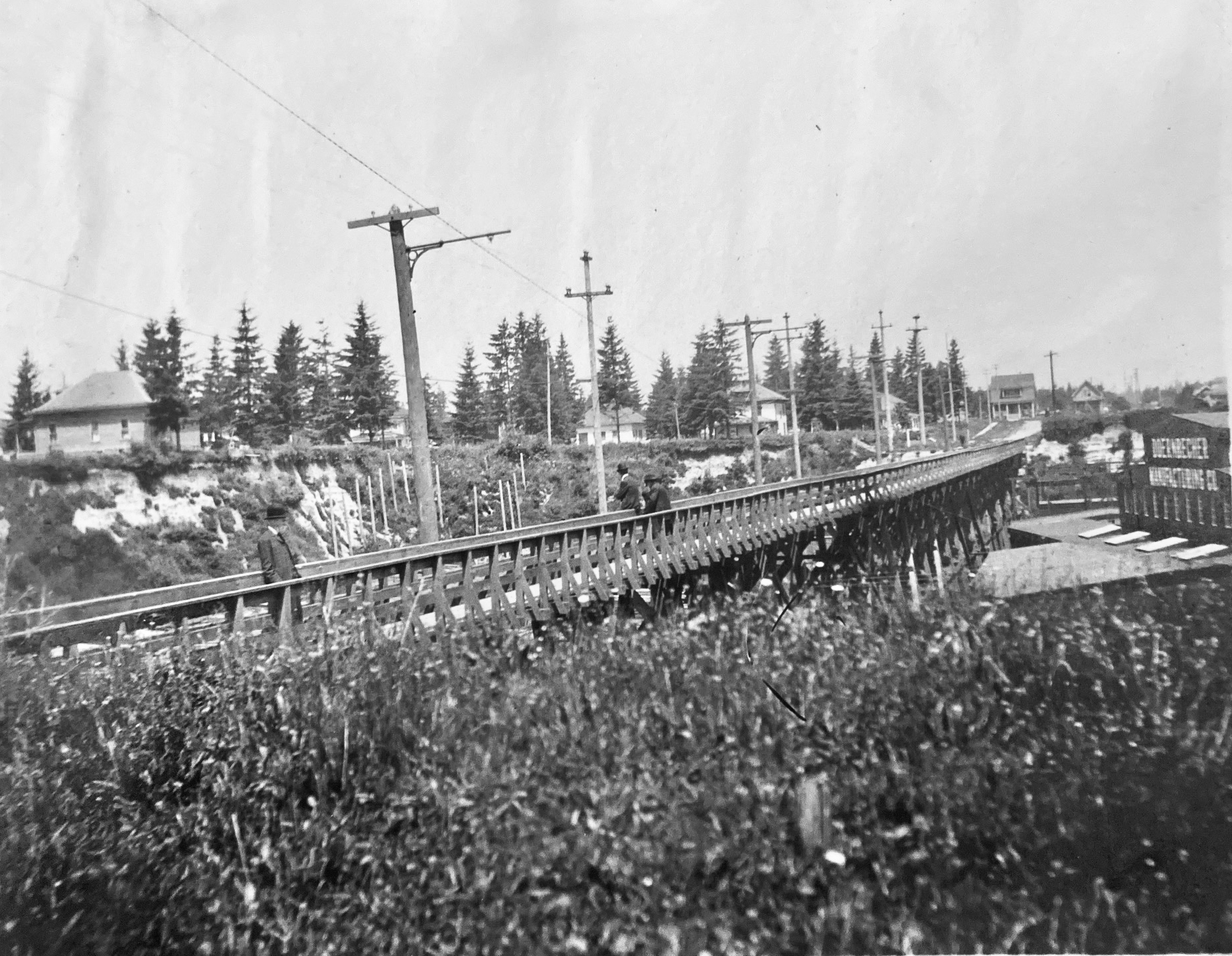
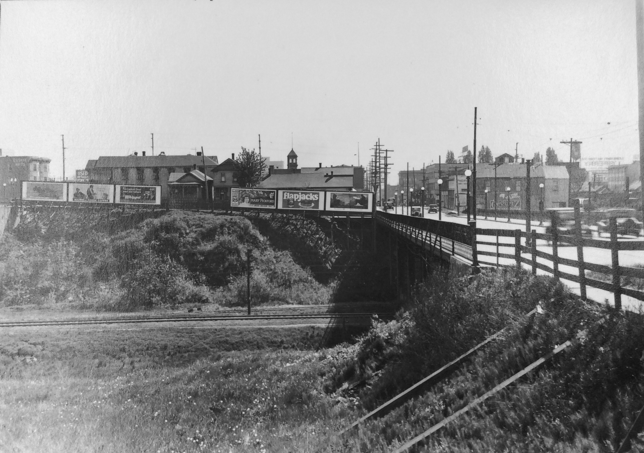
A friendly reader has shared a photograph from her great-grandparents’ photo album and wondered about where it was taken, when, and what it depicts. We love a good photo detective mystery like this, which enables a deep dive back into the landscape of the 1900s. Have a good look at it for detail, and then we’ll discuss:
Courtesy of Phillips Family Archive
You’re looking north at a newly-completed wooden streetcar and pedestrian trestle bridge over Sullivan’s Gulch (where today’s Banfield / I-84 runs) at about NE 28th Avenue, just south of today’s Hollywood West Fred Meyer. The trestle existed for only a short time–from 1903 to 1908–before pressures from a growing Portland replaced it with a concrete span, which was later echoed by new bridges at NE 21st and then at NE 33rd. Its short lifespan says so much about development about this part of the city during the years immediately after the Lewis and Clark Exposition, which ushered in waves of change for Portland.
But first, the trestle: 800 feet long, an average height over the ground of 35 feet, costing $2,000 to build, including simply a rail line and a narrow sidewalk on the east side of the span. Built between November 1902 and January 1903 by the City & Suburban Railroad, one of the several streetcar companies that served Portland during those years, later subsumed into the Portland Railway Light and Power Company system.
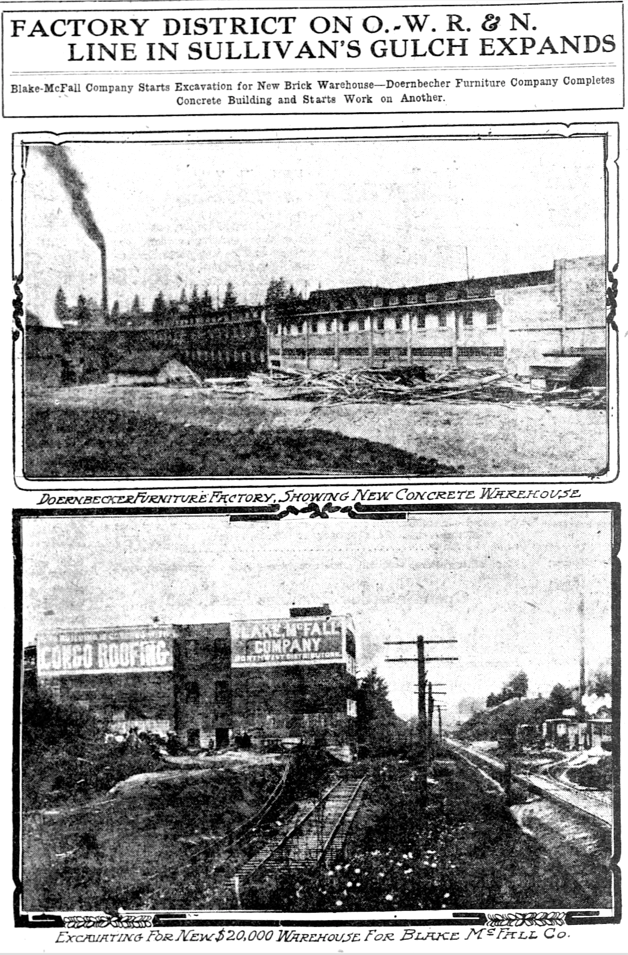
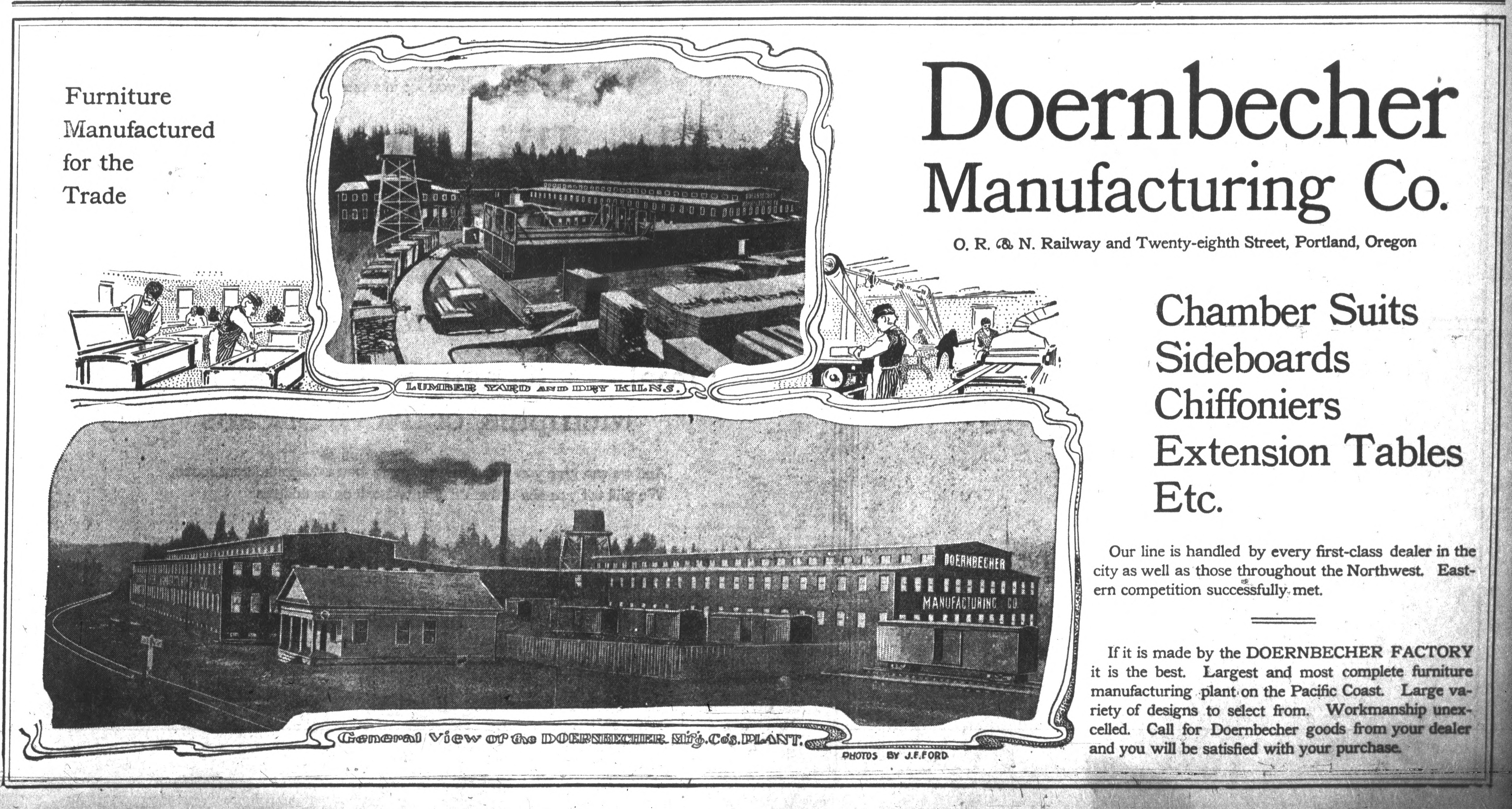
And here’s where it gets interesting: City & Suburban built the trestle under contract to the Doernbecher Manufacturing Company, a furniture factory, which was Portland’s largest private employer at the time and which operated a sprawling five-acre factory site at the bottom of the gulch just beneath the trestle. Thousands of workers made the trip into and out of the gulch each day and having a means of easy access was helpful for the company, which had opened the factory just a few years earlier in 1899. If you haven’t heard about the factory, you can read more and see photos in this piece, which was the second installment of a series we’ve written on the history of Sullivan’s Gulch. Today’s giant U-Store storage complex is the skeleton of what once was Doernbecher Manufacturing.
City & Suburban Railroad operated the East Ankeny Line, which terminated in the streetcar barns that once stood near NE 28th and Couch, about a mile due south. For the executives at Doernbecher, it was an obvious proposition to pay the railroad to extend its line north straight up 28th, build the trestle and two prominent stairways down, so workers could come and go conveniently. Meanwhile, City & Suburban was also eyeing service to the neighborhoods taking shape to the north of the gulch, and the possibility of a loop with the existing streetcar service that ran up Broadway into Irvington and later Alameda.
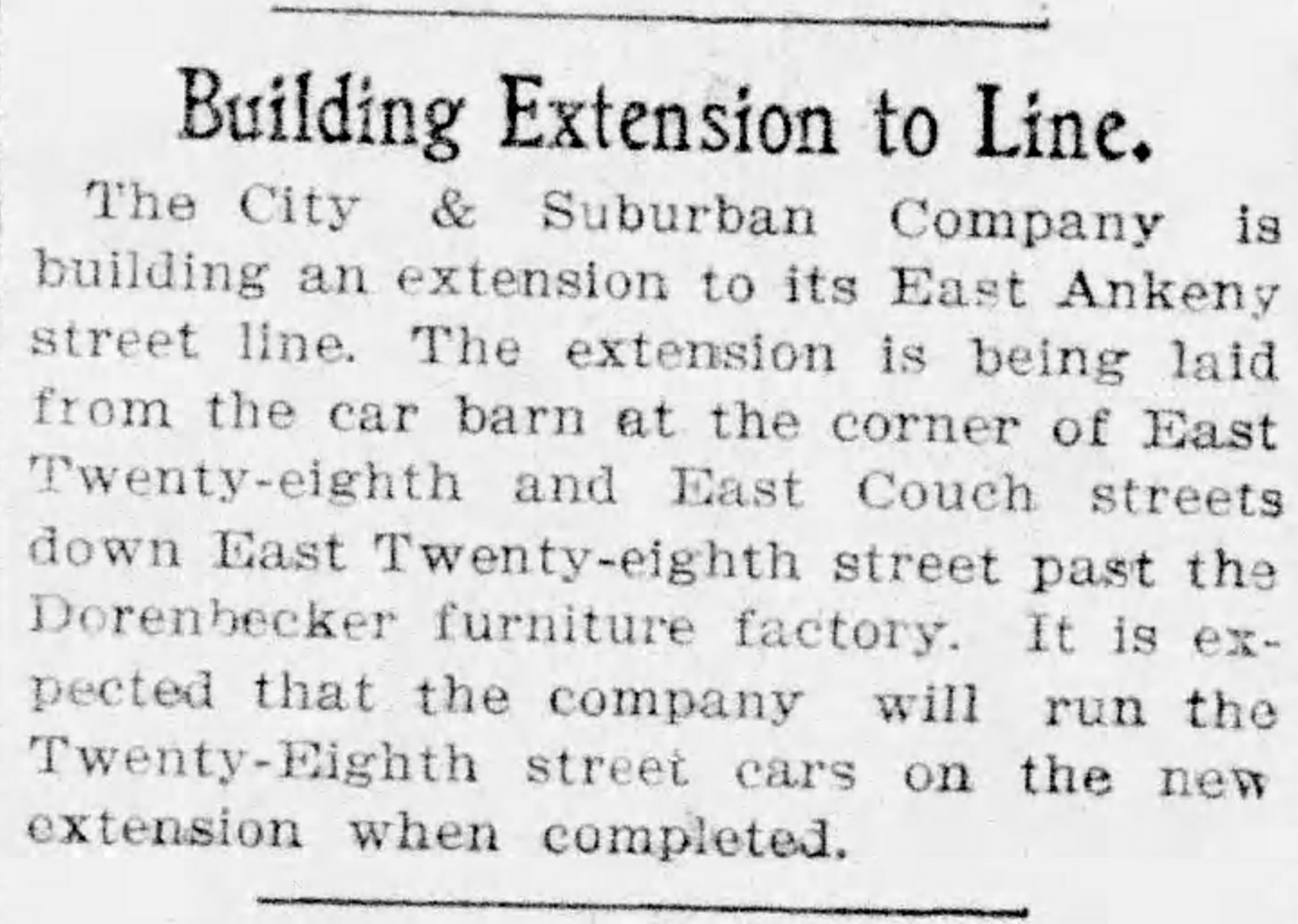
And so it was in August 1902 when construction of the line extension began:
From The Oregon Journal, August 19, 1902
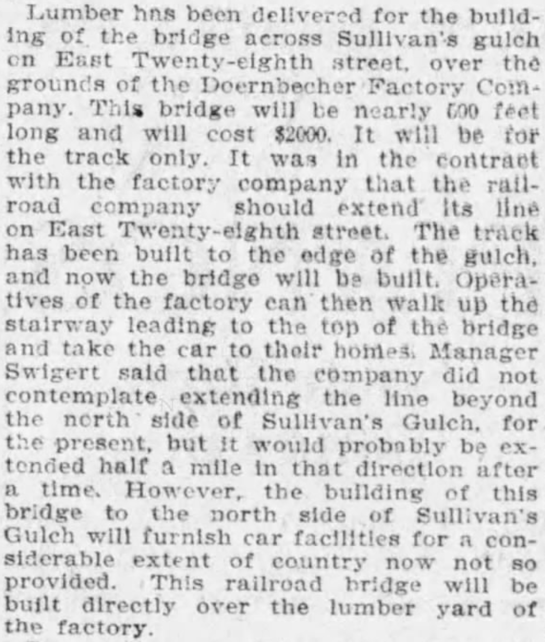
By November, the extension was in and grading was underway at the lip of the gulch to prepare for the trestle. Wood was being stockpiled for construction:
From The Oregonian, November 12, 1902
Trestle construction began in earnest in December and was completed in January. Later that year, the East Ankeny Line was extended a bit farther north to an end-of-the-line stop at NE 28th and Halsey. The envisioned loop with the Broadway Streetcar never materialized.
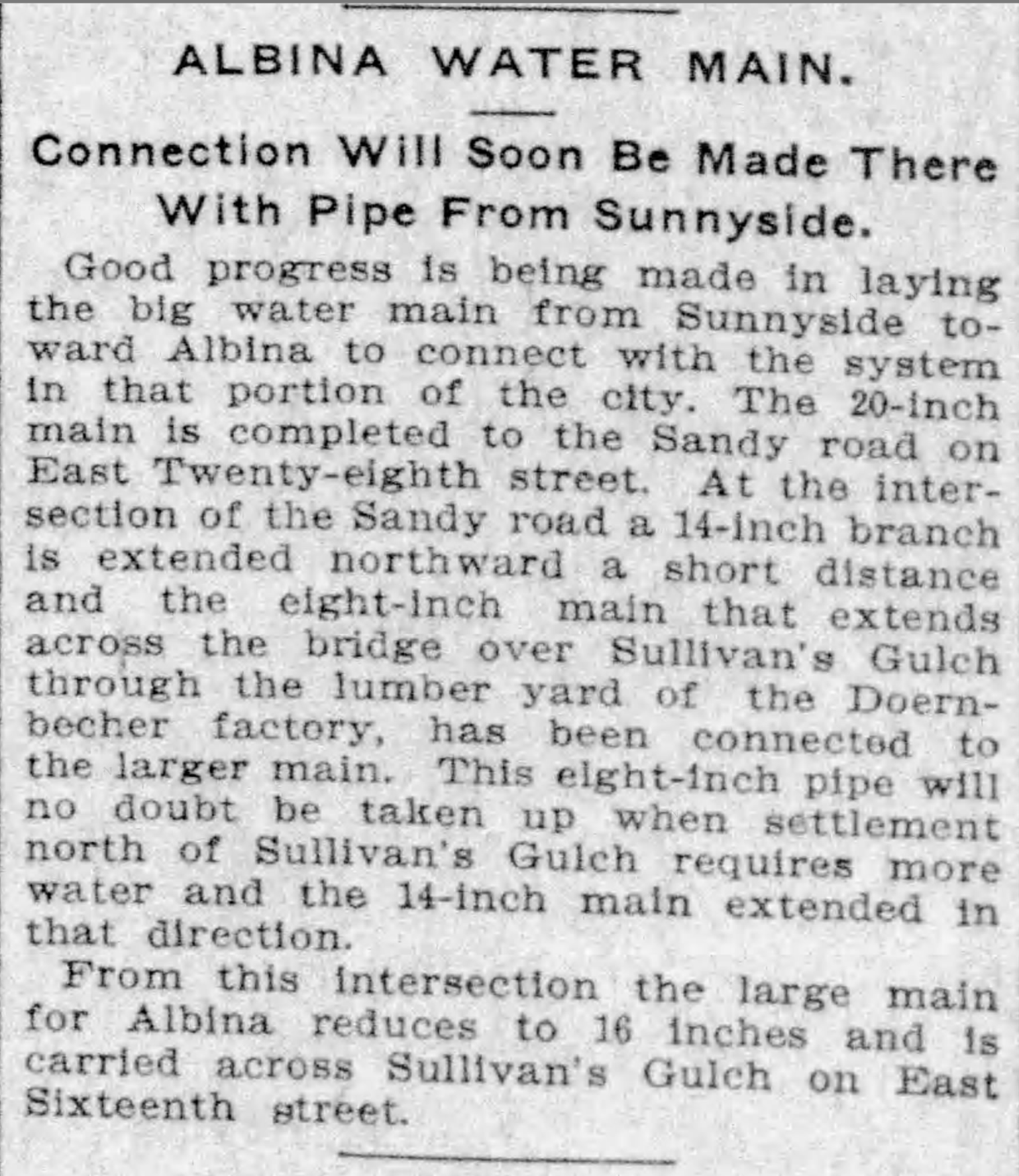
The trestle enabled a broader infrastructure that began to serve middle Northeast Portland. In November 1903, an 8-inch water main was secured to the wooden structure carrying public water for the first time into this part of the city:
From The Oregonian, November 5, 1903
In 1907, following the Lewis and Clark Exposition and with home construction and residential land speculation fever running high, residents of the area began to lobby for a wider multi-use crossing of the gulch in this area. The trestle was replaced in 1909 by construction of a concrete viaduct.
The story of sleuthing the photograph is interesting too:
We knew the Doernbecher story in this location, and could see the “Doernbecher Manufacturing Company” painted on the side of the building in the photo. The alignment of the Doernbecher building, slightly angled to the crossing, is still evident today in what may well be the very same building.
The homes pictured at the edge of the gulch, several of which are still standing today along NE Wasco and Multnomah streets, provide a tell-tale indicator this view looks north.
The Sanborn Fire Insurance Map from 1909 also helped, lining up nicely with the Doernbecher lumberyard seen in the old photo through the rungs of the trestle railing and mentioned in the news stories. Knowing the buildings were to the right (upgulch) and the lumber yard was to the left (downgulch) also confirmed direction of the view.
Detail from 1909 Sanborn Fire Insurance map.
The Sanborn also shows the Oregon Railway and Navigation mainline (much later the Union Pacific) which travels through the gulch and was the reason Doernbecher cited the factory there in the first place. The bowler-hatted gentlemen on the trestle walkway are probably looking down as a freight train passed by underneath. Look carefully and you can see the electric and telegraph lines that followed the tracks running perpendicular to the trestle in the mid-ground. The 1909 Sanborn shows the concrete bridge which replaced the trestle.
Do you have old photos you’re trying to make sense of? We’re always glad to help.
The AH blog has been quiet lately because it’s been a very busy winter on many research fronts: specific homes and their builders and people; intersections that are undergoing significant change; the incredible story of three very specific long-lost panels of ornamental glass and the wonder of window restoration and sash making; puzzling questions about everything from street alignments (why is that bend there?), to front porches (what happened to my front porch?). Some interesting things to share in the weeks ahead.
Meanwhile, here are four fresh photos to wake things up a bit, echoing through from our recent series on Sullivan’s Gulch and the arrival of the Banfield Expressway.
You’ve driven past these buildings a million times: part of today’s big U-Store complex on the north side of the Banfield (I-84) at NE 28th, just west of the Hollywood West Fred Meyer.
Here’s a link to the installment from our Sullivan’s Gulch series that references the Doernbecher Furniture Company buildings, which you can still find today if you turn east off of NE 28th at Sullivan Street, just south of the Banfield. Go down that hill, through the tunnel, cross the tracks and take a look. The crossing is in the same place as it appears in this 19-teens photo above, courtesy of the Oregon Historical Society.
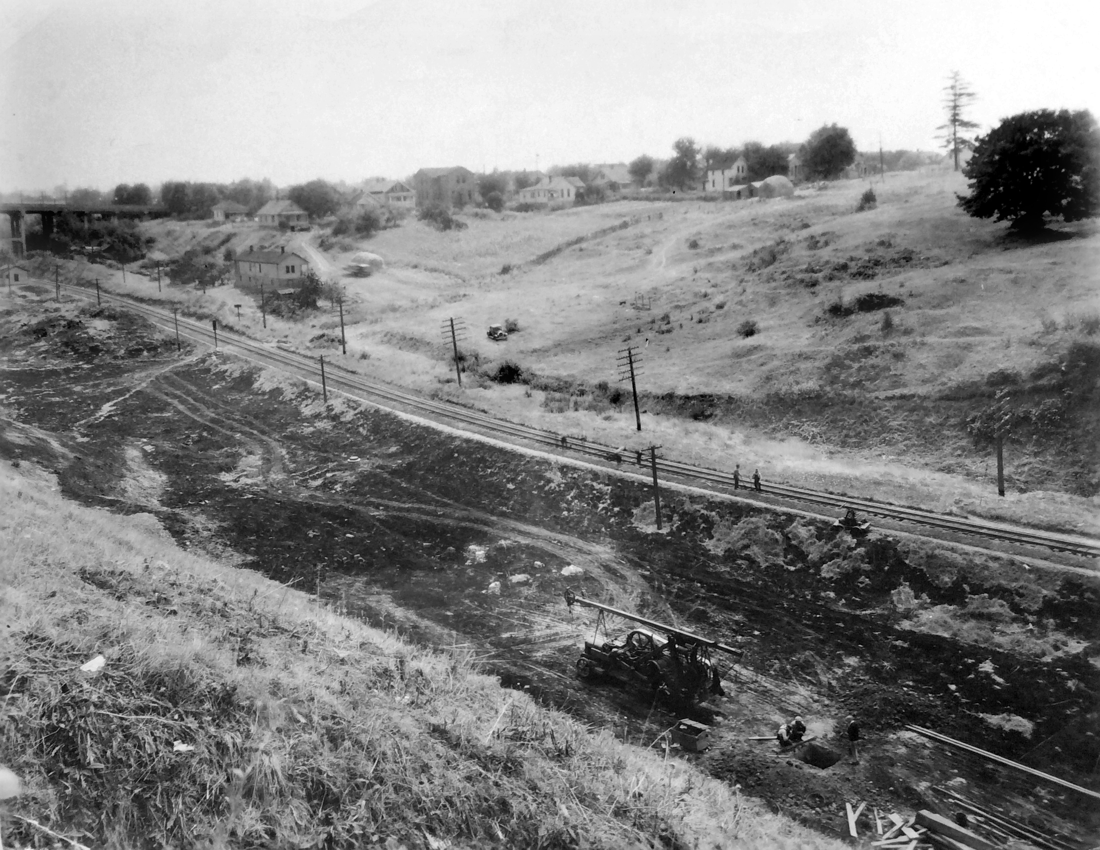
Here’s an even earlier westward view of the Gulch that we’ve come across, taken in the early 1900s just below where the State of Oregon office building is today on Lloyd Boulevard. The photo was taken to document progress on the trunk sewer that was constructed down the gulch (you can see it there in the bottom…the man is walking along the top of it). By triangulating the photo with old Sanborn Fire Insurance maps, our hunch is the houses on the brow of the gulch are at the corner of 7th and Irving. Look carefully, you can see the two towers of the Steel Bridge through the haze to the west.
Trunk sewer in Sullivan’s Gulch, looking west. From OHS photo file on Sullivan’s Gulch
The trunk sewer–and what went in it–was the source of legal wrangling between the various new subdivisions upstream that all wanted to dump their waste into it (but didn’t want to pay for it). The contents were still headed for open water in the Willamette River (not good), but the trunk sewer was an improvement over earlier more primitive ways of sewage disposal.
And our last gem below shows a 1930s view of the clubhouse at the old Lloyd Golf Course. This graceful building, now gone, sat near NE Irving at about 13th (across from Benson High School) and was the gateway to the old golf course.
Here’s more about the Lloyd Golf Course era, and one last photo below from AH reader Steve Goodman showing the building’s later days after the golf course was gone (and when Steve was learning to wash dishes in the dishroom of this very building).
During the Great Depression and the war years of the 1940s, Portlanders had more pressing things to think about than the future of Sullivan’s Gulch. If they thought about the gulch at all, it might have been about their jobs at Doernbecher’s furniture factory, or an escape to Lloyd’s golf course, or the sprawling Hooverville-shantytown at the mouth of the gulch.
Before the speedway: looking west down Sullivan’s Gulch through the Lloyd Golf Course, just west of the NE 21st Avenue viaduct, December 1947. The driving range fence and a corner of Benson High School are visible in upper left. Photo courtesy of Oregon Historical Society, OrHi 91595.
Through those tough years, many families and small businesses struggled just to make ends meet. A quick look at the census shows how many homes on the eastside took in a boarder or two, or had extended family living under the same roof. And if you were a citizen of color or an immigrant, the Portland establishment was more about keeping you down than helping you up.
An influx of workers associated with shipyards and the World War 2 effort brought continued growth particularly on the eastside, and further industrialization along the Willamette and Columbia rivers. Between 1920-1950, our population increased by more than 115,000 people.
Many of those people had cars.
Completion of the Ross Island and Burnside bridges in the mid 1920s allowed direct access to downtown from the eastside. The Ross Island Bridge, completed in 1926, was the first major Willamette crossing that did not include a streetcar route, an important choice and signal of things to come.
By the late 1920s, automobile use had outpaced streetcar ridership and east-west arterials were increasingly clogged with car commuters morning and night. Between 1913 when the Broadway Bridge opened and 1928, the total number of automobile registrations in Oregon increased from 10,165 to 256,527. A powerful force had been unleashed that was going to re-make the landscape.
Another indication of our early car-related growing pains: in 1927 voters approved a street widening levy that literally remade Burnside Street by removing entire portions of buildings and adding street lanes to cope with increased traffic. Similar work took place on Northeast Broadway in the early 1930s.
Looking west at NW 6th and Burnside during the widening project. Buildings on both sides of the street were cut back to make way for more lanes and more traffic. This was not a popular move as Portland struggled with growing pains. Photo courtesy City of Portland Archives, image a2001-062-2
Despite these changes—or perhaps because of them—City Council received an increasing number of complaints about traffic on Fremont, Broadway, Burnside, Stark and Hawthorne. The writing was on the wall for a bigger traffic congestion “fix.”
In 1944, City Commissioner William Bowes brought up C.A. McClure’s earlier Planning Commission speedway vision. The State Highway Commission—chaired by T. Harry Banfield—was on board and suggested the city not grant any more building permits along the Sullivan’s Gulch right of way. If the speedway vision was going to come to pass, it was time to stop allowing development along the edges of the gulch. By agreeing, Portland inched closer to endorsing the project.
As the war years ended, the topic rose to the top of Portland civic life and news coverage.
From The Oregonian, February 24, 1946
City Council placed a money measure for the expressway on the May 21, 1948 ballot asking if Portland voters were ready to pass a $2.4 million tax levy for the city’s share of a $10.5 million project to build a gulch expressway that would theoretically ease traffic problems. Interestingly, also on the ballot that day was a city ordinance requiring the leashing of all dogs…council didn’t want to be alone with just its fingerprints on that explosive decision either.
The resulting public dialog and advertising campaign about the expressway levy produced fireworks as people and businesses chose sides:
From The Oregonian, May 20, 1948
From The Oregonian, May 19, 1948
Portland City Club added its voice and recommendation with a report considering the pros and cons of the expressway, including an awareness for Portlanders that construction would require demolition of more than 110 homes along the right-of-way.
The results of the vote were an unequivocal no: Portland was not interested. (Results of the dog leashing ordinance were far less clear: it was defeated by a mere 4 percent margin).
From The Oregonian, May 24, 1948
But the establishment was strong and within a week, the Oregon Transportation Commission went ahead anyway with survey and planning work to prepare for major right-of-way acquisition. Spurned by Portland voters, T. Harry Banfield and the commission decided to look elsewhere to fund the speedway vision.
During the week after the landslide vote, The Oregonian editorial board expressed its surprise about the Highway Commission’s decision to go ahead anyway, but endorsed the new highway as necessary for progress:
From The Oregonian, May 27, 1948
Soon, things began to happen, with tangible progress beginning to show on the eastern end of the project and then proceeding west toward downtown. Portions of neighborhoods were bought and houses moved or demolished:
From the Oregon Journal, August 21, 1949
Later in 1949, the Highway Commission had to revise right-of-way acquisition costs upward from $2.4 million to $4.8 million. In August 1950, T. Harry Banfield died while on a fishing trip in Gold Beach, but the vision was well on its way into implementation. By early 1952, the first construction contract for grading at the far eastern end of the highway in the Fairview area had been let for $400,000. In March of 1955, the Doernbecher factory in the gulch at NE 28th Avenue closed and its furniture-making machinery sold at auction. In January of 1956, seven of the Lloyd Golf Course putting greens were sold to Riverside Golf and Country Club for an undisclosed price.
Photos from the 1950s make it clear just how much gulch-widening and dirt moving would be required, particularly in the big bends between NE 21st and NE 37th.
Oregon Journal photo from June 3, 1956, early on in the construction process. Looking up-gulch east from the 21st street viaduct, the rail line visible on the left is running up the bottom of the old gulch and the excavating equipment is widening the south bank with lots more work to do to make it wide enough. Caption on the photo reads “Banfield freeway is being gouged from the earth.” Photo courtesy of Oregon Historical Society.
On October 1, 1955, the highway opened between NE 42nd and Troutdale. Two years later, with funds from the major highway infrastructure bill signed into law by President Eisenhower, the final two miles were completed. By 1960, the Banfield Freeway was fully operational and a century of transformation in the gulch was complete, from natural area to homestead to manufacturing hub, golf course and shantytown.
The deep curves west of the Hollywood neighborhood and the last western stretch to downtown, from the Oregon Journal, September 23, 1957. “Paving of Banfield route progresses. This aerial view looks east from above NE 28th avenue viaduct. At lower left is old Doernbecher furniture manufacturing plant. Upper viaduct is NE 33rd avenue. Only one small stretch above 33rd avenue viaduct is unpaved.” The Hyster plant is also visible in the upper left corner. Courtesy of Oregon Historical Society.
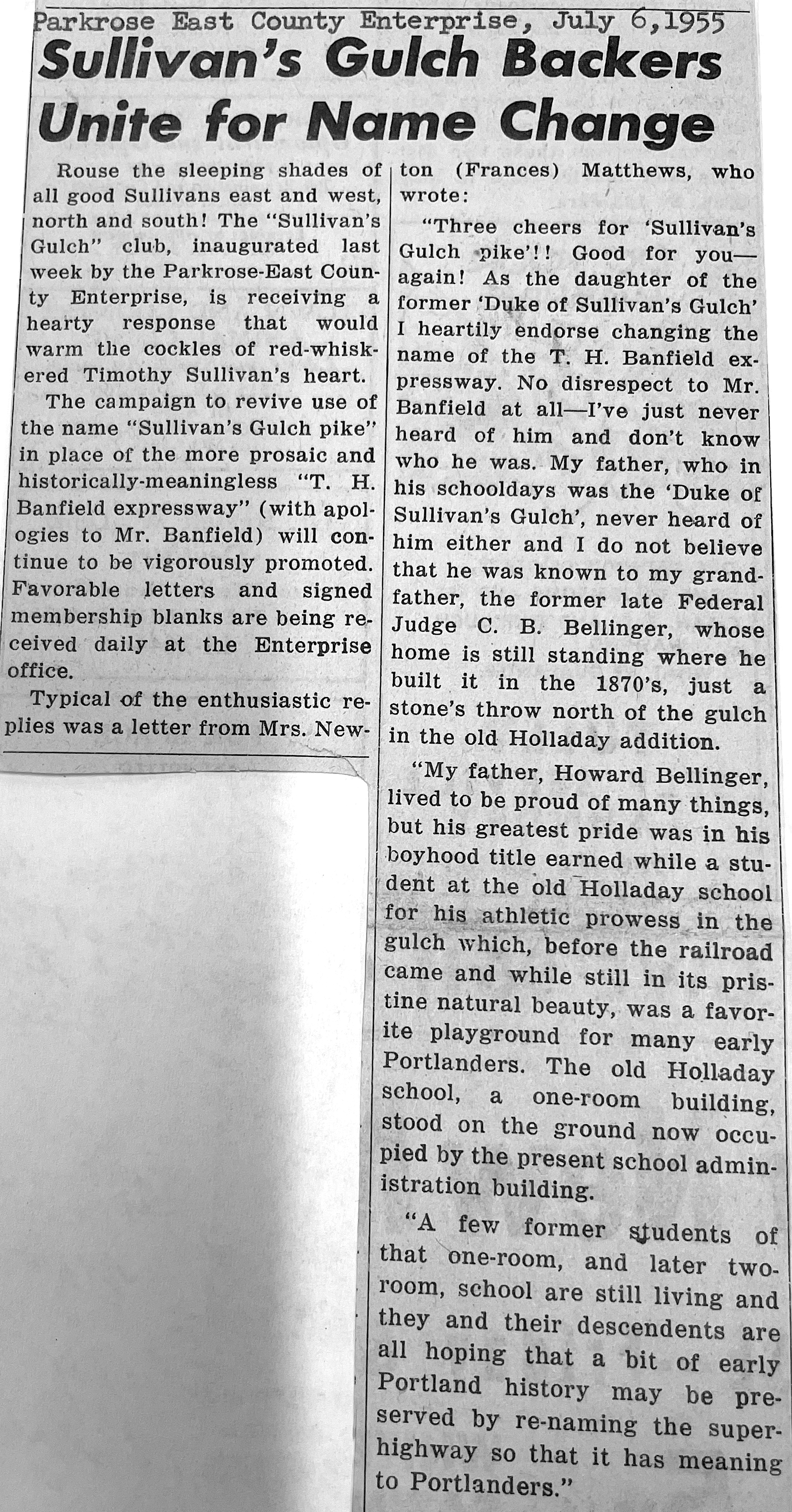
Despite all the changes brought about by the speedway vision, some weren’t quite ready to embrace the gulch’s new identity. A grass-roots campaign that began (and ended) in Parkrose attempted to claim local history, reminding us once again about the importance of places and their names.
Today, it remains the Banfield. But some of us know it’s still Sullivan’s Gulch.
From the Oregon Journal. Banfield Expressway looking west from NE 12th Avenue Viaduct, about 1960. Photo courtesy of Oregon Historical Society.
We’re writing this month about Sullivan’s Gulch. Some readers have wondered what makes this geographic feature a gulch—which Webster’s defines as a deep or precipitous cleft, a ravine—and where exactly it is. Good questions.
A couple of maps of the area might help. Take a look first at 1897:
In this 1897 USGS quadrangle map (used here courtesy of City of Portland Archives) we see Sullivan Gulch called out specifically on Portland’s eastside, and you can follow the contour lines (each one represents about 25 feet in elevation change) showing the depression or ravine that begins on the east at about today’s NE 60th and runs west to the Willamette. We feel about 60th is probably the reasonable eastern edge of the gulch, which functioned as a sub-watershed funneling water downhill to the Willamette River.
By the way, while you’re looking at this neat old map (click to enlarge), have a good look around and see how many features and roads you can identify, and be sure to take a look at the extent of development in eastside neighborhoods: Woodlawn and part of Irvington are there. Concordia-Vernon-Sabin-Alameda and points east are not. Can you spot the Alameda Ridge? Don’t you wish you could explore the old Columbia Bayou along the top of the map?
Most early 20th Century Portland newspaper references identified the geographic boundary of Sullivan’s Gulch as the area between today’s MLK out to about today’s NE 33rd Avenue.
There used to be plenty of other gulches that opened up into the eastern banks of the Willamette, but most of them were filled in the early days. Read more about that here.
Here’s a look at a more recent shaded relief map from National Geographic that shows elevation change and the gully running along the bottom, supporting the case that NE 60th seems to be a reasonable eastern boundary.
It’s been a place of constant change, and as we’ve seen so far, has been used pretty hard over the years. But the biggest changes were still to come.
Continuing our four-part series on Sullivan’s Gulch. The first chapter examined homestead and early railroad history. In this chapter we explore how manufacturing shaped the area during the first half of the 20th Century.
In the early 1900s, the railroad came to define Sullivan’s Gulch, connecting Portland to points east and serving a growing manufacturing presence in the gulch proper and along its shoulders.
From The Oregonian, May 7, 1911.
Engineers had filled in the marshlands at the mouth of the gulch where it met the Willamette River in an attempt to keep seasonal flooding from damaging rail infrastructure. On frigid months, the ponds that formed there—about where today’s I-84 merges with Interstate 5—were used as ice skating rinks by residents of nearby eastside neighborhoods. Other nearby gulches were used as sewers and dumping grounds, some were filled in.
The rails up the gulch were necessary infrastructure for a growing Portland, and they were a major attraction, particularly for neighborhood kids. Here’s a memory from former resident Bob Frazier, shared in the January 27, 1952 edition of the Oregon Journal:
“The gulch was a terrible place for kids, but at the time it was wonderful. In a way, living by the gulch was something like living next to a roundhouse. The trains puffing through Sullivan Gulch never failed to attract us and stir our fiendish little imaginations. Whenever we could sneak away from home for a few minutes, our crowd of 4 and 5-year-olds would bee-line for the gulch to watch No. 17, which as I recall came through sometime between nap-time and supper-time. The whistle of No. 17, screeching toward the Willamette, will, I fear, become meaningless to the next generation.”
For Frazier and his gang—and several generations of kids as surrounding neighborhoods built up—the gulch was a land of forbidden adventure that included digging caves into the slopes, hunting pheasants, building rope swings, playing with fire, and playing in deep puddles.
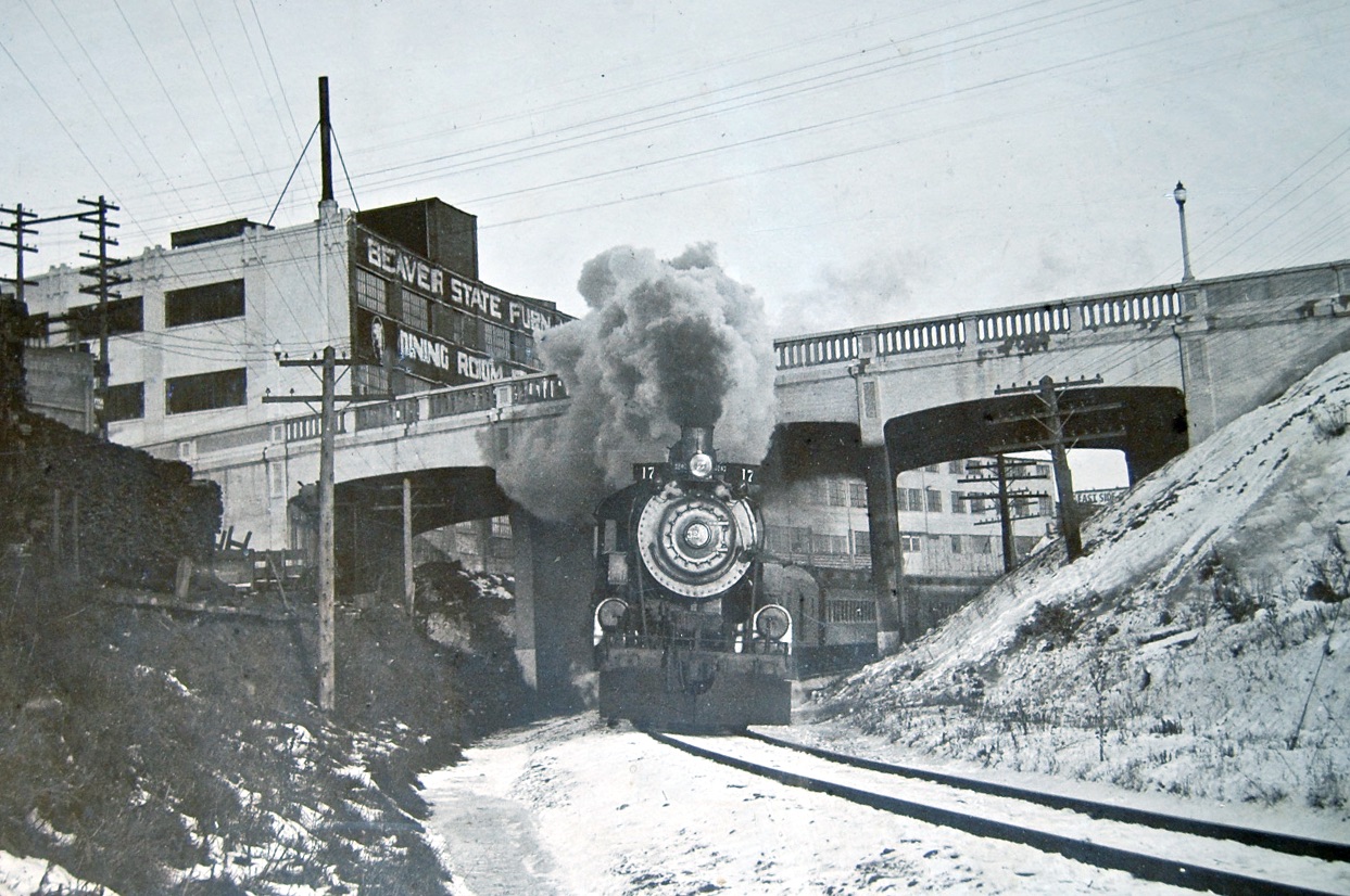
The legendary Oregon Railway & Navigation Engine 17 passing under the NE 33rd Avenue viaduct, January 20, 1929. The Beaver State Furniture building to the left is today’s graffiti-covered former Gordon’s Fireplace Shop at NE 33rd and Broadway. Note how much narrower the gulch was than today: major widening in the 1950s made room for the Banfield Expressway, requiring replacement of the viaduct.
Heavy manufacturers quickly found the value and utility of locating their factories along the rail line in the bottom of the gulch and along its sides: cheap close-in property not suitable for residential development; easy trans-shipment of products to distant markets; good access to workers from eastside neighborhoods, including a handy link with the streetcar system.
In 1899, the Doernbecher Manufacturing Company acquired five acres of property in the gulch at NE 28th on the north side of the tracks, where they built what TheOregon Journal referred to as “The biggest furniture factory under one roof in the world.”
From The Oregon Journal, December 25, 1904.
With thousands of factory workers reporting to this area each day, access and transportation became crucial. In 1902, a viaduct at 28th carried the 28th Street Streetcar on a spur north from the Montavilla line across the gulch where it stopped at Halsey. Two large stairways led down the north side of the gulch to the factory below. Today, it might be hard to imagine all of the activity in this area, but up until the 1940s (and the booming shipyards associated with the war effort), the Doernbecher factory had the largest industrial payroll in the Portland area.
A view of the Doernbecher Furniture Factory, looking toward the northwest, from The Oregonian, February 25, 1912. The bluff of Sullivan’s Gulch is visible behind.
By the early 1930s, residential development had completely surrounded the Doernbecher factory and while the neighbors appreciated the employment opportunities, they were having a hard time breathing and were tired of cleaning up the soot that came out of the Doernbecher chimneys.
The factory generated its own power from wood-fired boilers that belched thick smoke and ash. In August 1933, neighbors lined up to protest at city hall, including a demonstration that left an impression on at least one newspaper reporter from the Oregon Journal, writing on August 26, 1933:
“The protestants, in virtually every talk that was made, urged that they did not desire the factory removed or shut down, that they are in full sympathy with the undertaking to give more employment but that they do feel that they have submitted to the smoke nuisance as long as it can be endured and are entitled to relief.”
“A spectacular feature of the hearing was the marching up to the council desk, where the committee sat, of groups of housewives and their depositing on the desks of bags and packages of soot and cinders they had swept up in their homes.”
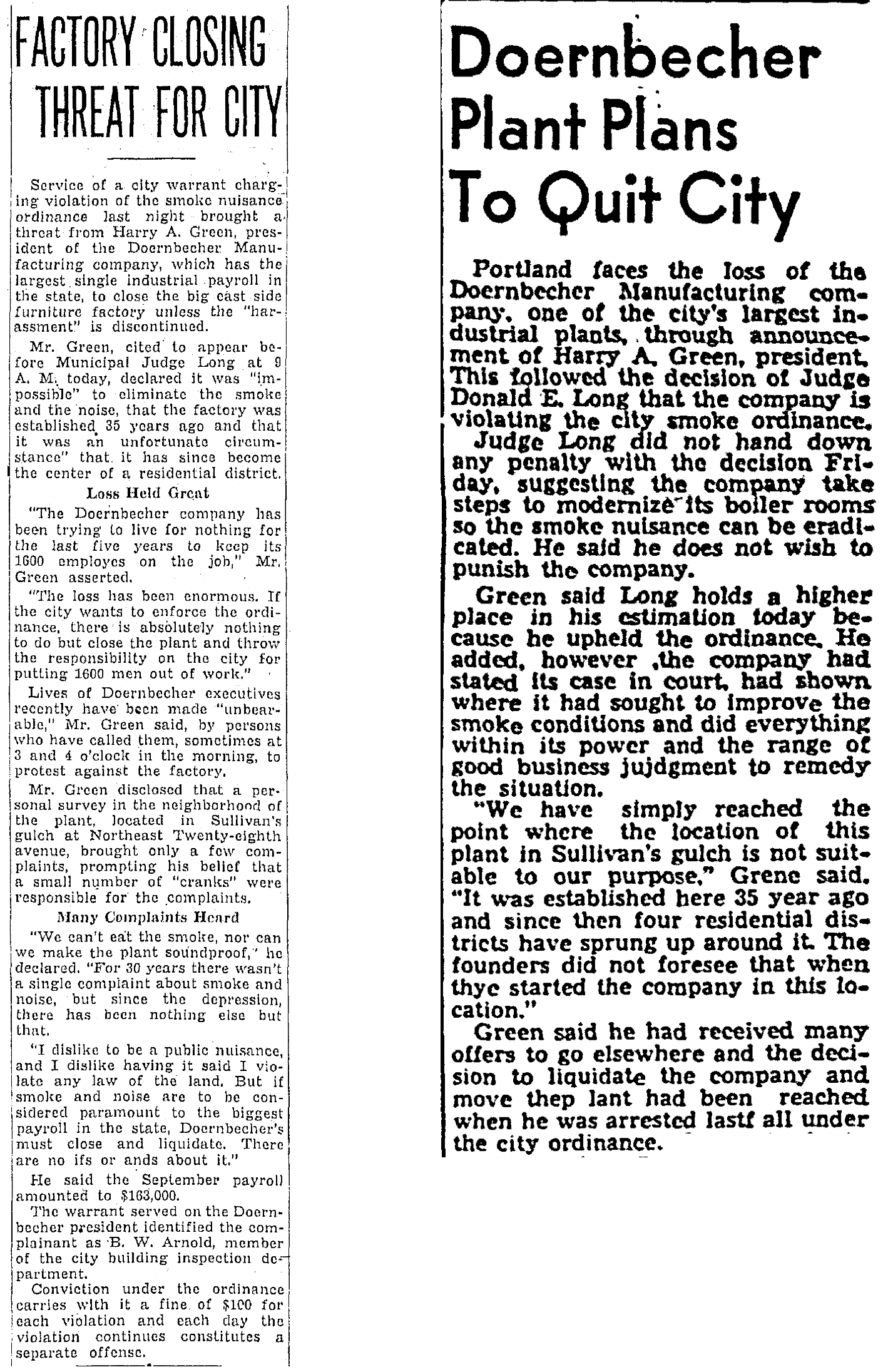
Company president Harry A. Green was actually arrested on October 15,1935 for continuing to ignore a city ordinance about nuisance smoke. In a hearing that week before Municipal Judge Donald E. Long, Green threatened to close and liquidate the company.
From The Oregon Journal, October 16, 1935 (left) and The Oregonian, March 21, 1936
Here’s another look at the factory—this one taken in 1947—showing that the company didn’t actually close, but continued with its operations, and with heavy smoke. In fact, the factory continued to operate until 1955 when it closed, according to Harry Green, due to unfavorable union negotiations. Today, the area functions as a giant public storage facility and in a fitting twist of history, hosts several small craft furniture studios.
Looking northwest, NE 28th and Sandy crossing at a diagonal left to right, 1947. The NE 28th Avenue viaduct spans the gulch, and a portion of the roof of the Doernbecher plant. Note the smoke plume. Source: City of Portland Archives A2005-001-577.
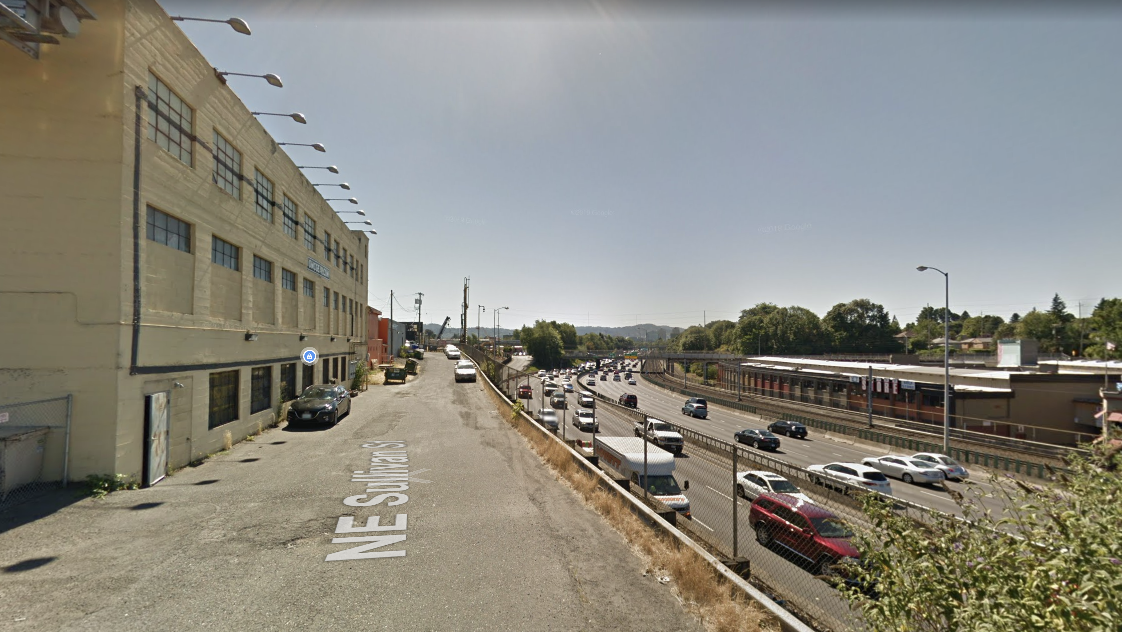
The street that today leads down into the gulch, under the Banfield, across the tracks and into the old factory building? It’s NE Sullivan Street.
The former Doernbecher Furniture Factory today, Google Streetview.
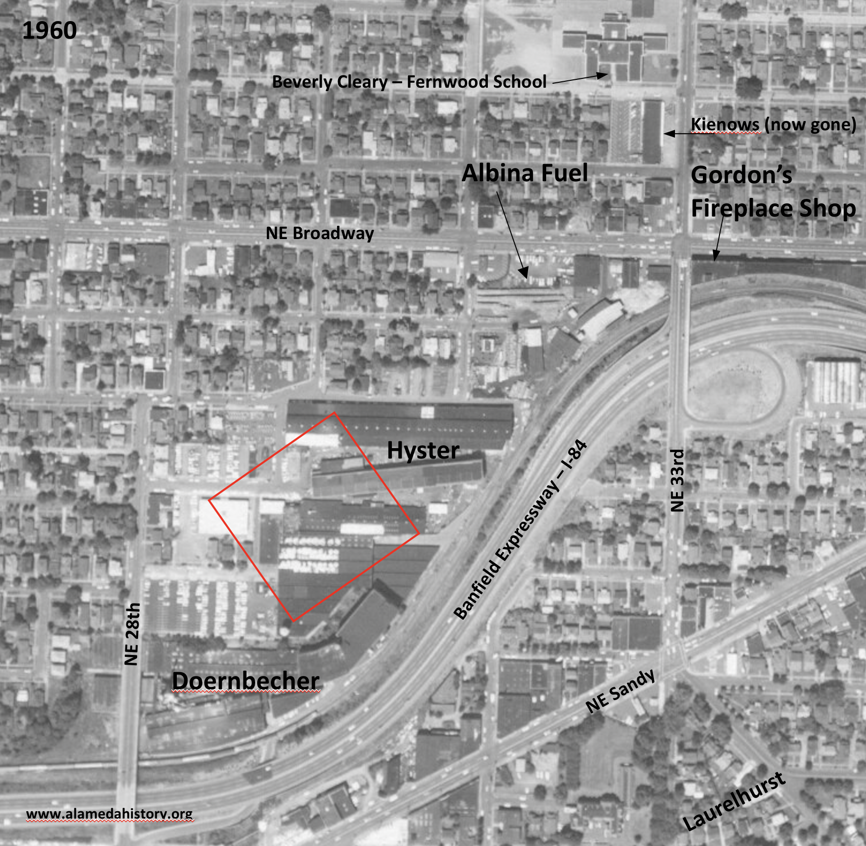
Just up-gulch to the east, where the ravine bends to the north, was more heavy industry and manufacturing. First a foundry, then a machine shop and other metal manufacturing, the site of today’s Hollywood West Fred Meyer eventually became the sprawling industrial campus of Willamette Hyster, later known simply as Hyster, where the company made forklifts and other heavy equipment. Hyster operations in the gulch began in the 1940s and took over parts of the surrounding neighborhood. Over the years, Hyster acquired and demolished an estimated 17 nearby homes on the flats above the gulch north and west of the factory to make room for its operations
Detail of a 1960 aerial photo that shows the location of Hyster and its neighbors. The red outline is the approximate location of today’s Hollywood West Fred Meyer. Note that the NE 33rd exit off the Banfield was east of 33rd. Photo courtesy of University of Oregon Map and Aerial Photography Library.
Hyster’s immediate gulch neighbor to the northeast was Albina Fuel, a storage yard for all things combustible: wood, sawdust, coal and heating oil. And all surrounded by a growing neighborhood that was closing in on both sides of the gulch (and within two blocks of a busy elementary school).
An early 1940s view looking south (Broadway in the foreground) at Albina Fuel at Broadway and 33rd. The viaduct over the gulch is visible in the background, with neighborhood houses just beyond. Photo courtesy of Albina Fuel.
It wasn’t just heavy manufacturing at this big bend in the gulch: A factory built in 1911 by the Oregon Home Builders at the southeast corner of 33rd and Broadway—which many of us probably remember as Gordon’s Fireplace Shop and Tarlow’s Furniture before that—was a huge cabinet and carpentry shop for its first few years.
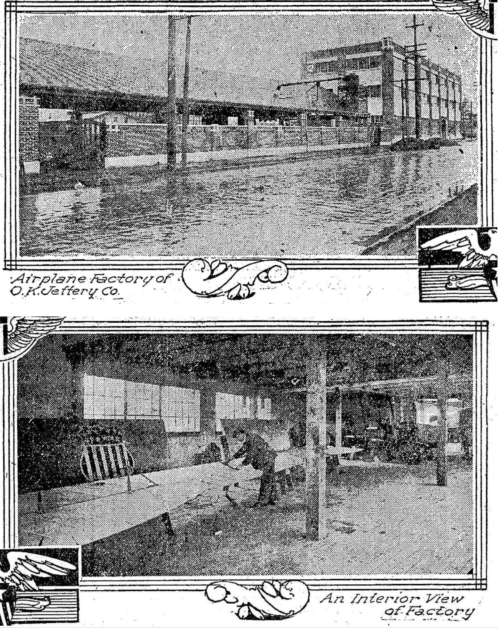
Oregon Home Builders constructed its built-ins and kitchen cabinetry here until charismatic company president and budding pilot Oliver K. Jeffery transformed it—briefly in 1917 until funding reality caught up—into a place where spruce aircraft parts were built.
From The Oregonian, January 1, 1918. Top photo looks east on NE Broadway just east of NE 33rd.
In an August 5, 1917 story in The Oregon Journal, Jeffrey was quoted as saying his workers were cutting 25,000 board feet of spruce parts daily for airplane stock and that the product would be shipped to eastern finishing plants. He told reporters: “Large orders for finished material have been secured by my company and the present force of 26 men will soon be doubled.” The plant closed a few months later.
Many different products have been manufactured in this building over the years: excelsior, pasta, furniture. It even hosted street-facing retail including barber shops and diners in the 1940s and 1950s. From the 1960s into the late 1970s, the building was Tarlow Furniture. Today, it’s become a canvas for graffiti artists and vandals while its current owners go through the permit process for redevelopment, which will include ground floor retail and a preschool, with apartments on the second and third floors.
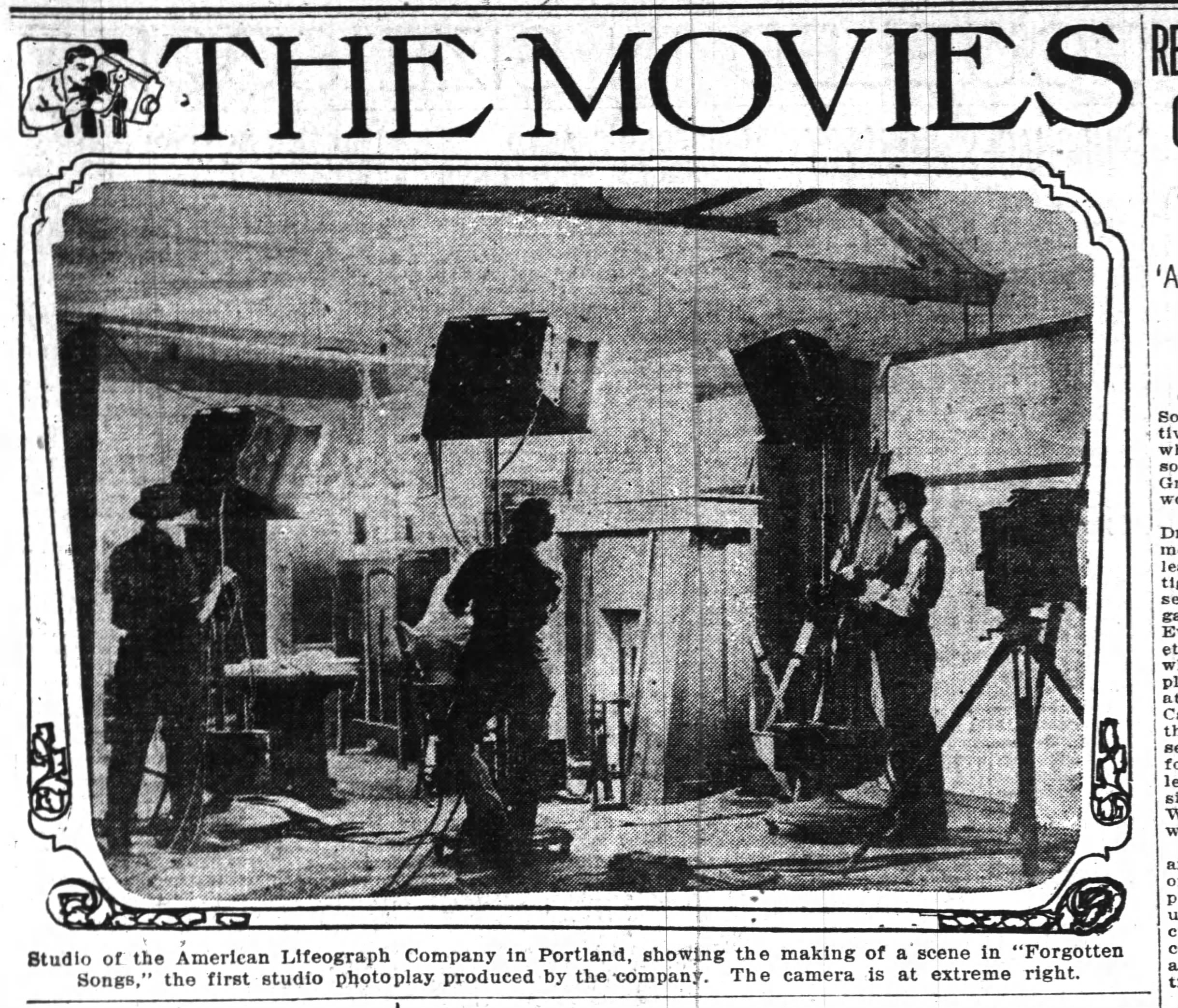
One little-known early Sullivan’s Gulch product was the movie business. The American Lifeograph Film Company started in 1911 as this new industry was just taking hold…for a brief time Portland could have become Hollywood. From its headquarters on the south edge of the gulch at NE 33rd and Wasco, the company made dozens of silent films. But a major fire in March 1923 wiped them out and competition from Hollywood pulled that energy and talent south.
The American Lifeograph Company had a large movie studio building at NE 33rd and Wasco, just a few blocks south of the Oregon Home Builders workshop. This photo shows the studio in a story from the Oregon Journal on February 4, 1914. The studio burned in 1923 ending the company’s presence in Portland.
Aside from all this teeming industry down in the ravine, just getting across the gulch has been a challenge for the ages, and received constant newspaper attention in the early 1900s as the city strategized about bridge construction and how to pay for it. Here’s a look to the south in the teens at the Grand Avenue bridge over the gulch.
Completion of the 21st street viaduct in October 1912 cost $70,000 and at the time was one of the most modern structures of its kind. The grand opening on October 21, 1912 featured a parade of “loaded auto-trucks, followed by a number of giant steamrollers” as if to make the point that it was sturdy.
Looking east toward the brand new 21st Street Viaduct, 1912 Source: Oregon Historical Society.
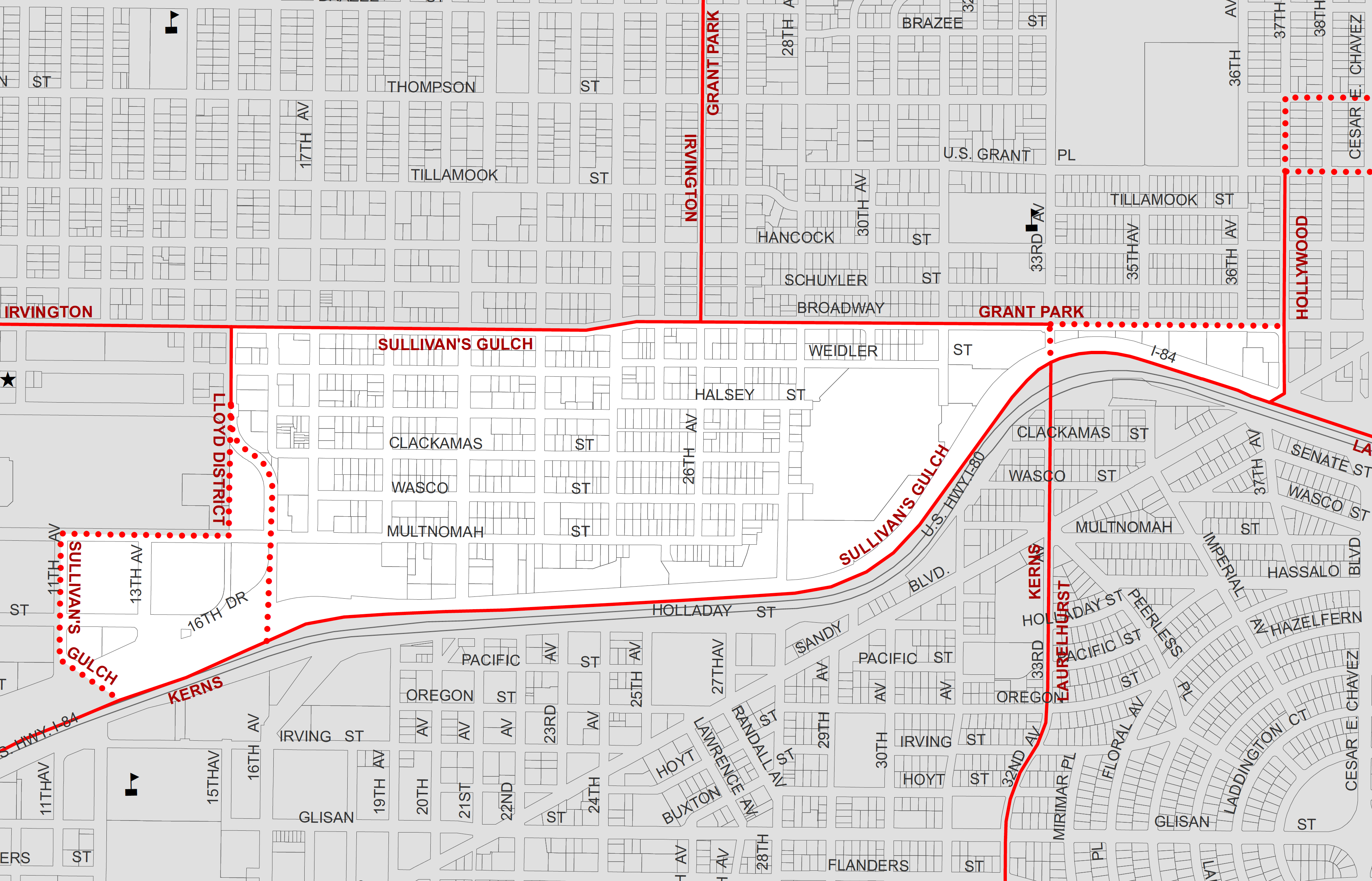
We’ve had an opportunity in the last few months to take a deep dive into the history of the Sullivan’s Gulch neighborhood, which technically runs from NE Broadway to NE Holladay between NE 11th and NE 37th, sandwiched between the Holladay Park and Irvington neighborhoods to the north, and the Kerns neighborhood to the south. There are so many interesting chapters and stories to share about the Gulch, so we thought we’d capture some of them into a few posts.
A scene from the Gulch in the 1920s, looking southeast directly toward the old Sullivan homestead on the south slopes, from about NE 16th. Click to enlarge. Note the gentle swale, and the older homes near the top of the ravine. People on the far slope are haying their land, and in the foreground, maybe drilling a well. You can see the 21st Street Viaduct at far left. Photo courtesy of Oregon Historical Society, OrHi 53652.
This week we’ll look at the original Sullivan homestead and the coming of the railroad in 1882.
Future posts will focus on the Doernbecher Furniture Manufacturing plant at NE 28th, which was one of the largest employers in Portland (and as we’ll see one of the heaviest air polluters of the early 20th Century); the golf course and Hooverville that occupied the lower gulch in the 1930s-1940s; and construction of the Banfield Expressway (which, by the way, was uniformly opposed two-to-one by Portland voters in 1946).
First, let’s get our definitions straight.
Regular AH readers know we have a fondness for Portland’s plat maps. Within Sullivan’s Gulch alone are at least eight underlying plats filed by developers, beginning with the earliest in about 1870. Plats are essentially subdivision plans for lots and streets, filed with Multnomah County. Sometimes called additions—plat boundaries are different from neighborhoods. Today’s neighborhood names are essentially social-political boundaries; plats are engineering plans. Here’s the Sullivan’s Gulch neighborhood today, according to Portland’s Office of Community and Civic Life:
More than 900 plats make up today’s City of Portland, most of them filed during the early years, by developers trying to make a favorable impression by choosing an attractive sounding name. As it turns out, what things are named is a big deal.
Something notable about plats in today’s Sullivan’s Gulch is that they were some of the earliest on Portland’s eastside, dating to the 1870s at a time when Portland was actually three towns: Portland, which was basically just the westside; East Portland, where these plats are located; and Albina to the north and east. In 1891 these three separate towns combined to create the City of Portland.
For the record, there is an actual plat called Sullivan’s Gulch, but it was filed just five years ago and relates only to about a block and a half near the corner of NE 21st and Multnomah. And of course there is the Sullivan’s addition of 1870, platted by John J. Sullivan, son of the original homesteaders Timothy and Margaret Sullivan. But let’s not get ahead of ourselves.
Turning the clock way back, we know the Gulch was shaped by the cataclysmic floods that coursed across the region associated with the breaching of ancient Lake Missoula.
We also know and acknowledge that these lands (and all lands that make up Portland today) were taken from the Multnomah and Clackamas bands of Chinook, the Tualatin bands of the Kalapuya, the Molalla, and many other family bands and tribes, who were then forcibly removed from the home their ancestors knew for 500 generations.
The first people—who lived here and knew these lands for 10,000 years before Portland became Portland—traveled the length of the gulch and other routes between the Willamette and Sandy rivers.
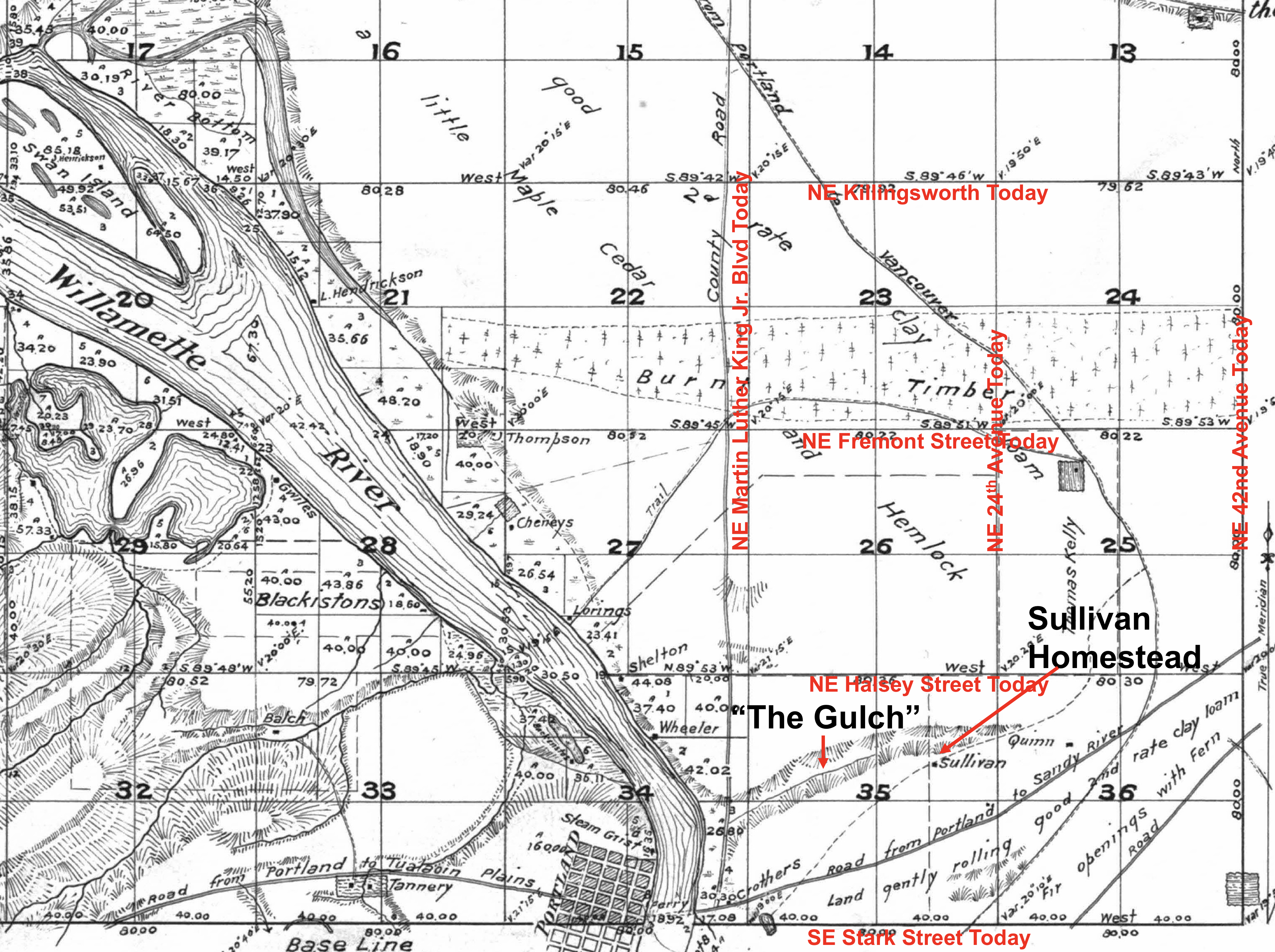
Here’s the first map produced by the U.S. Government Land Office and the Surveyor General showing the surrounding area, including the Timothy and Margaret Sullivan Homestead. There’s lots to look at here, and we’ve added a few pointers in red for context.
Government Land Office Survey Map, 1852. Note that Boise-King-Sabin-Alameda-Beaumont-Wilshire was a wide swath of “burnt timber” and that Swan Island really was an island. The “Road from Portland to Tualatin Plains” roughly aligns with parts of today’s Canyon Road and the Sunset Highway. Portland was just a small grid of streets on the west side of the river (where the waters were deep enough to anchor ships).
Homesteader Timothy Sullivan left his native Ireland before the famine struck in 1847 and came to Portland about 1850 after a short time in Australia, where he met and married wife Margaret. They both became US citizens in 1855 and received title to the property from the U.S. Government in the early 1860s.
About that time, the Sullivans sold a portion of their new homestead to the Archdiocese of Portland, directly north across the street from Lone Fir Cemetery at SE Stark and 24th. Catholics could not be buried at Lone Fir Cemetery in those days, so the Diocese created a cemetery of its own—St. Mary’s Cemetery—which operated from 1858 until 1930 when the remains were relocated to the new Mt. Calvary Cemetery in southwest Portland. The site of the old St. Mary’s Cemetery is today’s Central Catholic High School.
Location of the former St. Mary’s Catholic Cemetery (indicated by arrow) on lands that were originally part of the Timothy and Margaret Sullivan homestead. The site of today’s Central Catholic High School. Map source: City of Portland 18982 Renaming Map by Stengele & Schiffers, Courtesy of City of Portland Archives.
Timothy Sullivan died in the 1860s and widow Margaret in the 1880s. Yes, their remains were buried at St. Mary’s Cemetery and later exhumed and relocated to Mt. Calvary Cemetery.
Here’s one of the few visible clues to the Sullivans today, this one-block long stretch of “Sullivan Street,” which is actually more like an alley (there aren’t any street signs here, just the ghostly Google label), perched on the south edge of the gulch behind Oregon Mt. Community at NE 29th. Directly behind this view, the street sweeps to the east, down the hill and under the Banfield for access to the U-Storage building, which is the old Doernbecher Furniture Factory.
Looking west along the Banfield Expressway (Interstate 84). Google Streetview image.
The Sullivans knew the area when it was a wild and somewhat remote place. But after their passing, when the railroad arrived in the spring of 1882, builders began to fill in the lower part of the Gulch to make way for the rails and to protect from Willamette River floodwaters. They also built the first steel bridge across the Willamette, the Albina yards to the north, and lots of infrastructure.
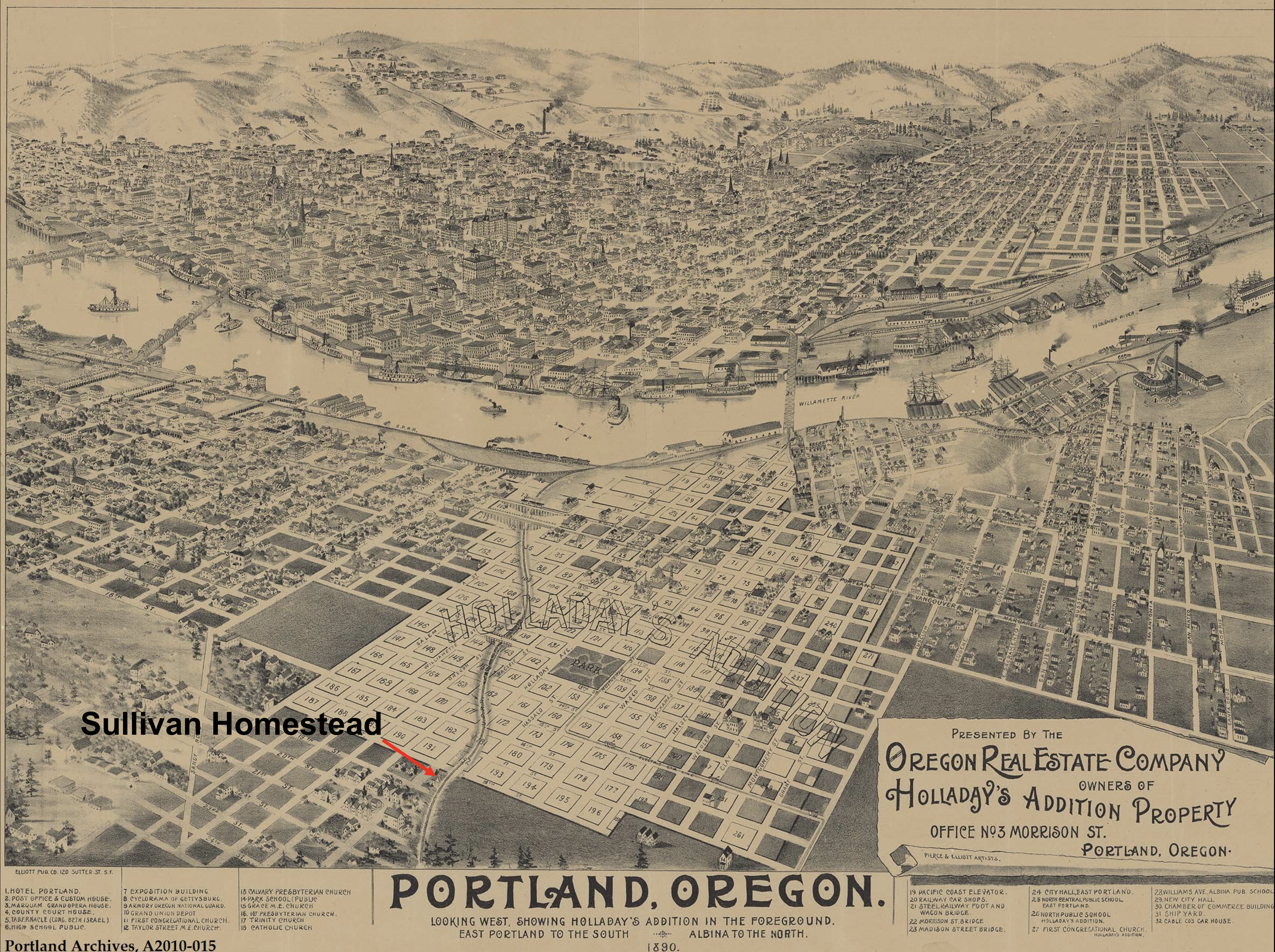
Here’s, a birds-eye view from 1890 looking west. This map was produced to market properties in Ben Holladay’s addition, which as we can see just happens to be at the center of the Portland universe. The red arrow indicates the location of the old Sullivan Homestead–and a water source / favorite bucolic picnic grounds known as Sullivan’s Springs–near today’s intersection of NE 19th and NE Pacific Street.
Oregon Real Estate Company birdseye view, 1890. Courtesy of Portland City Archives, A2010-015
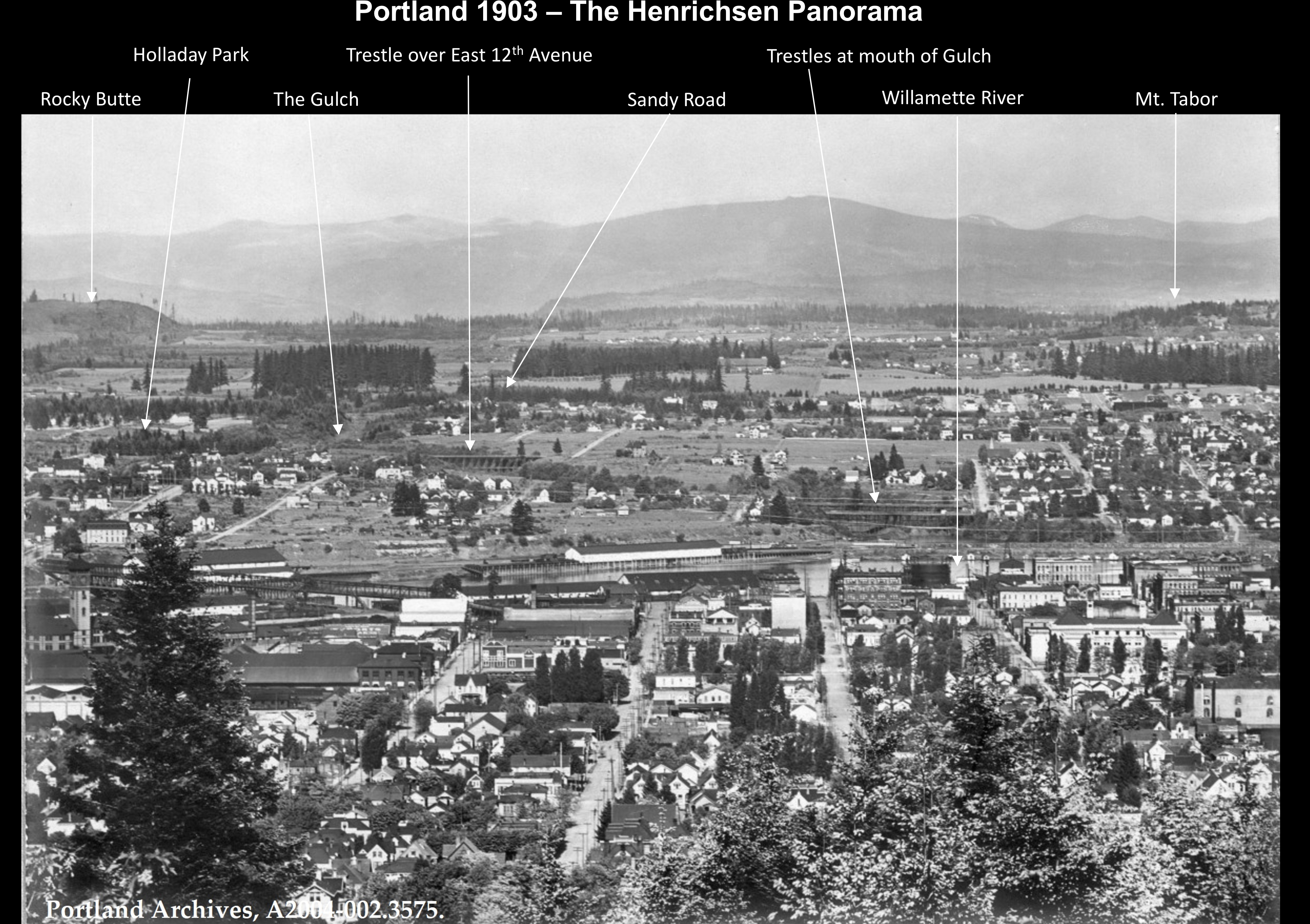
And just because we’re a little crazy for old maps and photos—and on the chance you might not already know about it—below is an amazing photograph from 1903, one of 14 tiles in a giant panorama called the Henrichsen Panorama, looking right at the mouth of the Gulch in 1903. You could spend an hour looking at this photo and its 13 siblings, but we’ve pointed out a few places on this one panel just for orientation, and to help you visualize this landscape before things really exploded on the eastside.
The Henrichsen panorama, one of 14 images taken in 1903. Courtesy of Portland City Archives. Image A2004-002.3575.
Arrival of the railroad ushered in a whole new wave of change for the Gulch and for Portland, including the siting of heavy manufacturing right alongside the rails for easy transfer and shipment. In our next post, we’ll explore the tension between industrial use in the Gulch and growing residential use in the uplands to the north and south.
The scaffolds and fences have come down from around the former First Universalist Church of Good Tidings / Metropolitan Community Church at NE 24th and Broadway, and soon the doors will open on the restored and repurposed 112-year-old church building.
The former First Universalist Church of Good Tidings was built in 1909 and has recently been restored and repurposed. It opens to the public soon. Photographed July 2021.
We wrote about the project here last November: neighborhood residents Brody Day and Dustin Harder have been adapting the old church into the new Steeplejack Brewing Company. The two acquired the building in April 2019 from the Metropolitan Community Church which was downsizing to a building in Southeast Portland following 42 years in the space. At the time, another offer was on the table from a local developer who wanted to demolish the church and build a five-story condominium on the site. After a meeting with the pastor and the congregation—and assurance that Harder and Day were planning to keep the building intact—they successfully closed the deal.
Steeplejack opens quietly to the public starting on Friday, July 23rd from 3:00-10:00 p.m. with a grand opening scheduled for Saturday, July 31st, when regular hours begin from 7:00 a.m.-10:00 p.m.
The old church has the distinction of being one of a few buildings in Portland dedicated by U.S. Presidents. William Howard Taft sealed up a small time capsule and set the cornerstone during the building’s opening on October 4, 1909. Day and Harder have the original box (it had been opened some years ago) and plan to set a new cornerstone, sealing in the old box, at 2:00 p.m. on Saturday, July 31st. Next week, they’ll be accepting very small time-travel items that might go into the box.
We had a chance to visit the newly-completed restoration as part of Steeplejack’s soft opening this week and offer these glimpses of the “new” old space:
The front door and location of the historic cornerstone and time capsule, which will be placed on Saturday. July 31 at 2:00 p.m. The original cornerstone was set by U.S. President William Howard Taft on October 4, 1909.The west face of the building. Note the heart shape in the large stained-glass window, and then have a look on the wall inside (below) as the sun shines through.An interior scene. Tables built with original structural wood reclaimed during the restoration.
Gordon’s Fireplace Shop, 3300 NE Broadway. Former house-part manufacturing plant owned by Oregon Home Builders President Oliver K. Jeffery and used briefly to manufacture wooden airplane parts in 1917.
One of Alameda’s most prolific home building companies—The Oregon Home Builders, Inc.—is also responsible for building an aircraft manufacturing facility that operated briefly: a building that endures in the neighborhood to this day.
You probably know this building as Gordon’s Fireplace Shop on the southeast corner of NE 33rd and Broadway, or maybe as Tarlow Furniture before that. But in the late 19-teens, after serving as a workshop for house parts and domestic carpentry projects that now reside as built-in cabinets in homes across Northeast Portland, the building moved into full aircraft production mode and began churning out spruce struts, beams and braces for “flying machines.”
First a little context about Oregon Home Builders and its president Oliver K. Jeffery…
Oregon Home Builders, Inc. and its owners had a big vision. They founded the company on a business model that involved selling shares of stock at .25 cents each to investors at large, and building and selling homes. They also built some of Alameda’s prized national register houses, including the Oliver K. Jeffery House at Regents and Shaver, and the Thomas Prince House at Alameda and Regents. Others, including the George Eastman House on Stuart Avenue—designed and built by Oregon Home Builders—should be on the register.
In 1914, the company built 45 houses here in northeast Portland, and drew plans for many more. As a base of operations for this big vision, Oliver K. Jeffery and his colleagues needed a workshop and warehouse near the market they were serving, and near transportation. So in 1915 they set out to build a warehouse on the Oregon Railway and Navigation Line in Sullivan’s Gulch, today’s Banfield corridor. Here’s a snippet that’s a tad fuzzy but readable from the January 17, 1915 pages of The Oregonian.
From The Oregonian, January 17, 1915.
But by 1917, O.K. Jeffery’s personal passions were focused more on airplanes than on homebuilding. A charismatic character in Portland business and social life, and a man of means, Jeffery received much coverage in the pages of The Oregonian during these years, whether in his role as a top Rosarian, his very public divorce proceedings, or his role as a trainee tank commander preparing for World War I. The story below in the August 1, 1917 edition focuses on the airplane factory building at 33rd and Broadway.
Click to read full size. From The Oregonian, August 1, 1917.
Apparently, there was a lot more going on with this story than meets the eye, (Jeffery’s homebuilding company was in the process of going bankrupt). The factory produced airplane parts for only a short time before running out money, but Jeffery’s love of aviation continued until his untimely death due to blood poisoning from a freak accident in December 1934.
Perhaps like us, you’ve driven by the building a million times and wondered about it. Following on that curiosity, and hoping for clues to the company that might have been forgotten in some nook or cranny in its upstairs floors, we dropped in for a visit over the weekend and can offer the following observations:
The folks at Gordon’s were helpful, and interested in the history of their building (which they’ve been in since 1990), but their collective memory of the building can’t see back around the corner of time. They do have a story here and there about a pasta manufacturing company that once inhabited the building. Some sense of the retail furniture company that operated there for 30 years. And a fabulous picture from 1929 that was first and foremost a portrait of Union Pacific Engine 17 coming around a bend in the track, but secondarily a picture of the building. See the distinctive brick pattern along the parapet? Look also how the building extends quite a ways east around the bend of the gulch.
Looking east in Sullivan’s Gulch on January 20, 1929 at Union Pacific Engine 17. The “Beaver State Furniture” building is no longer an aircraft parts factory. The building wraps around the rim of the gulch. Note also how much narrower the gulch is…widened in the 1950s to make room for the Banfield Freeway, requiring replacement of the viaduct. Photo courtesy of Gordon’s Fireplace Shop.
Check out this image below as well, which shows our aircraft factory building in 1956 as Erickson’s Furniture. The new viaduct associated with construction of the Banfield freeway (I-84).
Looking south on Northeast 33rd at Broadway. Construction of a new viaduct. Courtesy of City of Portland Archives.
During our visit, we learned that the building houses the second oldest freight elevator in Portland, and it’s big. Like a two-car garage that levitates between the first and third floors. It doesn’t take much imagination to see it filled with furniture or spruce airplane parts. But pasta? Hmm.
From the 1960s until 1980, the 22,000-square-foot building was home to Tarlow’s Furniture.
A detailed look at aerial photography of the area over the years (with thanks to Ed McClaran), confirms that the building did indeed once extend east across what is today’s parking lot, and connected up with the building that now houses Rose City Furnishings in the 3400 block of Northeast Broadway.
The view from the top floor is impressive: both up and down Sullivan’s Gulch to the east and west. North across the busy intersection toward the Dolph Park neighborhood. But there are no hidden nooks or crannies with artifacts from Oregon Home Builders. It’s a tidy and well-organized warehouse on the upper floors. Here and there you can tell from marks on the floor where heavy machines and equipment may have been anchored, or workbenches secured to the walls.
No aircraft machinery to be found here. Just a warehouse for Gordon’s Fireplace Shop.
But the aircraft heyday of the building passed briefly and it stands on the north rim of Sullivan’s Gulch as an artifact itself while the busy intersection below surges with traffic and big development plans. In the midst of shuffle and change, it’s a time traveler with stories to tell.


")


