To really understand the next installment of photos from the 1913 collection, it helps to visualize what the middle part of Portland’s eastside looked like then, and what was going on in the economy and life of the city. Following the Lewis and Clark Exposition, which put Portland on the map in so many ways, our population exploded: from 90,426 people in the 1900 census, to 207,214 by 1910.
Like shock waves rippling out across what had been a mostly agricultural landscape, development pressures began to reshape the dirt roads, orchards, dairies and forested clumps of the middle eastside. Meanwhile the economy began to heat up in the early teens as speculators, home buyers and homebuilders jockeyed to take advantage of the growing marketplace. Maps and a few precious photos from the early 1900s show this place as mostly undeveloped open lands, dotted with barns, scattered farm houses and dirt roads.
By 1913, the fields and hills of the middle eastside had been platted out into subdivisions, and the infrastructure of sewer, water, electricity and roads was trying to catch up with the vision sold by developers. In some places, a grid of streets existed, and a sprinkling of single family homes was being built, making visible the conversion from agriculture to residential use. To the north closer to Alberta, construction had been underway since the middle of the 00’s. Eastside neighborhoods closer to the river–Albina, Irvington, Ladd’s Addition, Woodlawn, the Peninsula–had been platted and growing as early as the 1890s.
Back in the day, the intersection of NE 33rd and Fremont–the focal point of this 11-photo series of glass plate negatives from City Archives–was a north-south wagon road to the Columbia River, and access point for the giant gravel pit near the top of the ridge. Surrounded on all sides by planned development, the intersection was in transition from dirt path to thoroughfare.
On the northeast side of the intersection, the Jacobs-Stine Company was ready to sell you a lot in the Manitou Subdivision. Just across Fremont to the southeast, the Terry & Harris Company wanted you to see the lots in Maplehurst. Our photographer from the Department of Public Works captured both views. Meanwhile, the mud puddle in the middle of the intersection reminded everyone the reality that for the moment, this was still a fairly rural place.
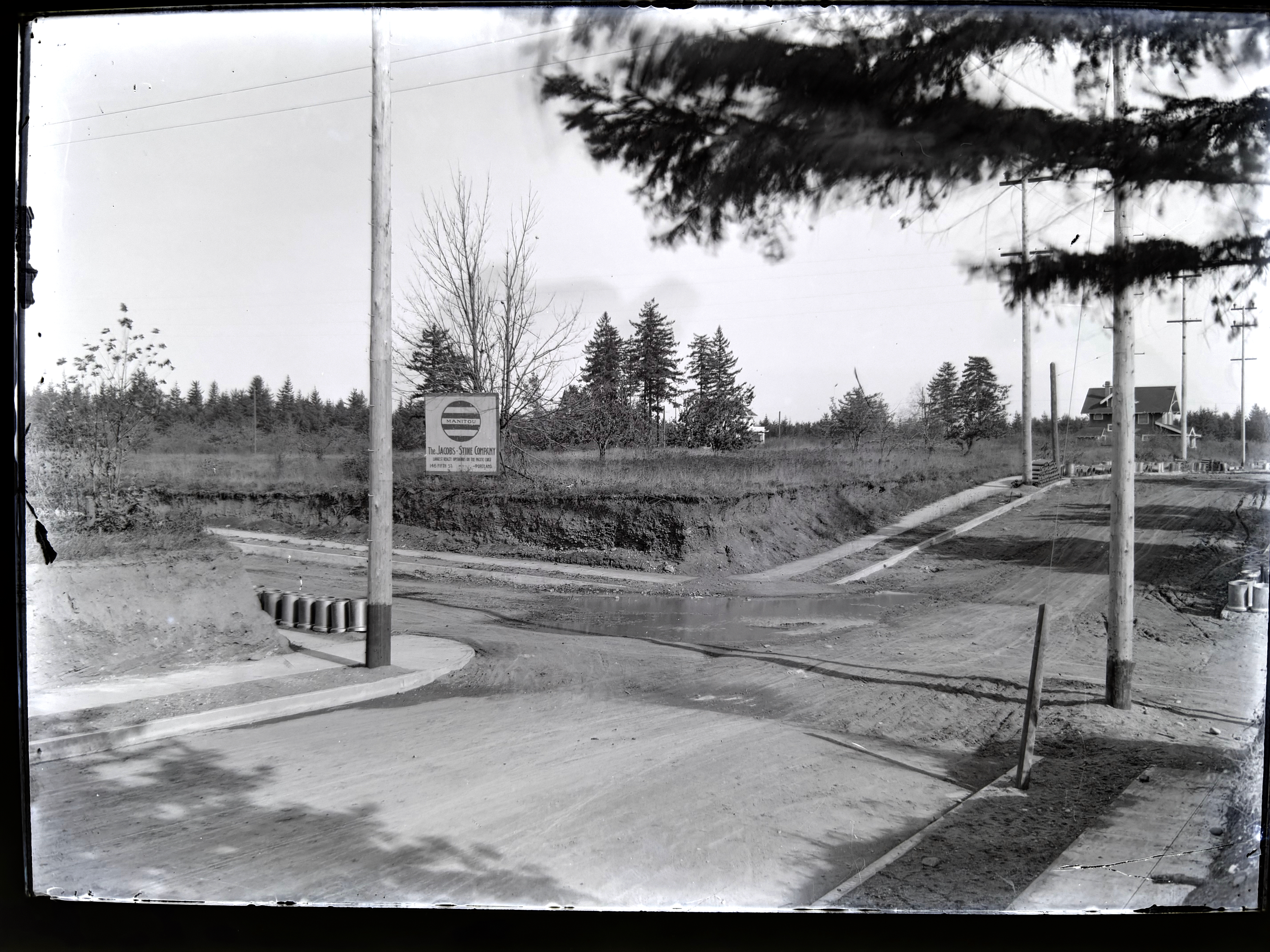
Looking to the northeast along Fremont from the southwest corner of NE 33rd and Fremont (33rd is passing from upper left to lower right). The house in the distance at right is today’s 3415 NE Fremont (built in 1912). Curbs and sidewalks are in (thanks to Elwood Wiles and Warren Construction), and ceramic sewer pipe is stacked near the curb awaiting installation. The Jacobs-Stine Company, boasting on its sign of being “The largest realty operators on the Pacific Coast,” was owned in part by Fred Jacobs, who would later die when his car tumbled off Stuart Drive in Alameda a few blocks from here, giving rise to the nick-name of that street as Deadman’s Hill. Photo courtesy of City Archives, image A2009.009.3613.
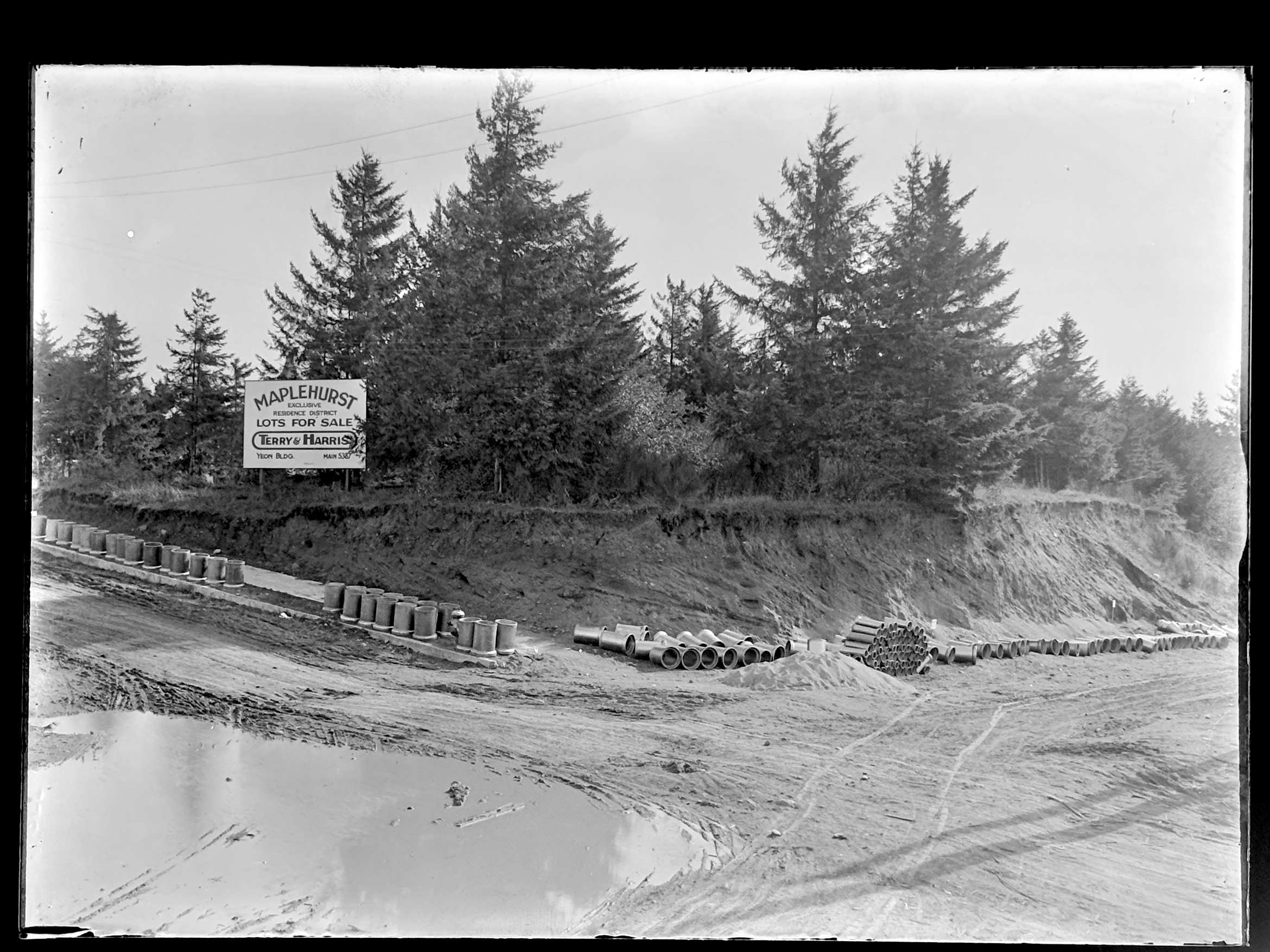
Looking to the southeast from the northwest corner of 33rd and Fremont. 33rd runs down the hill on the right. Fremont follows the slight rise to the left as it heads east. Sewer construction is evidently about to begin. Photo courtesy of City Archives, image A2009.009.3614.
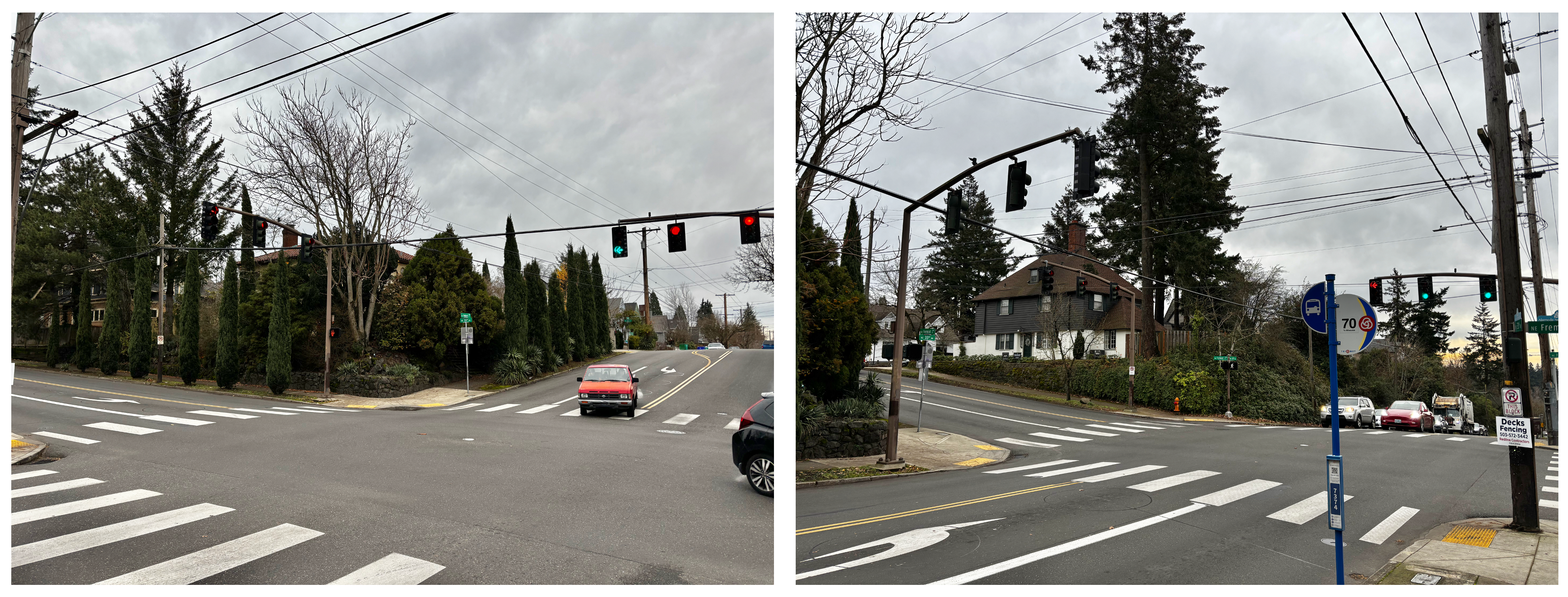
Left photo is similar to top, looking northeast. Right photo is similar to bottom, looking southeast.
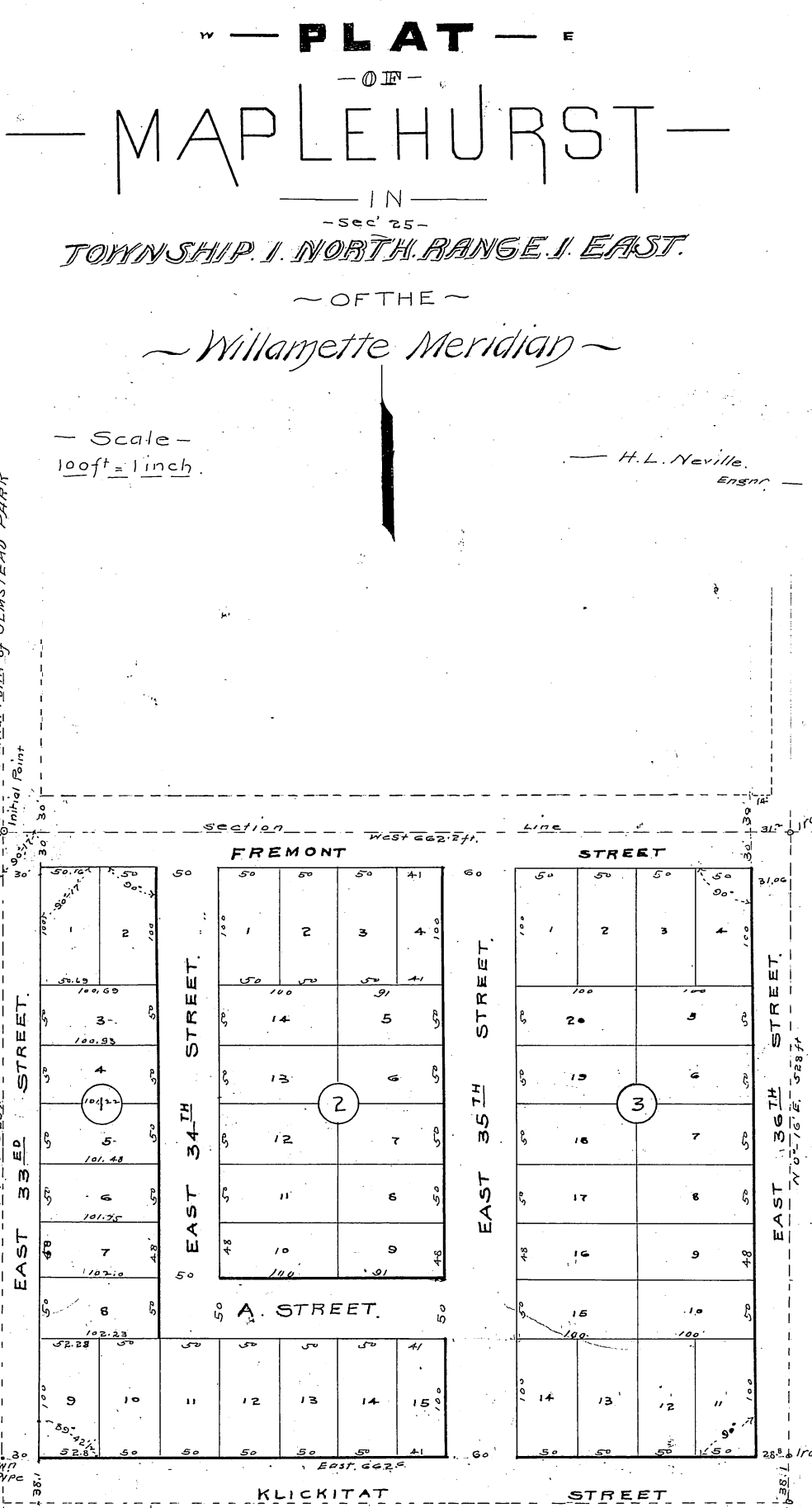
Maplehurst was platted in 1910 by Mary Beakey, who named a street for her family (labeled as A Street on the plat). It’s a relatively small subdivision–only three blocks and 43 lots, and exists up against a plat called Irene Heights, which was developed by the Barnes family, containing the Barnes mansion and multiple former Barnes family homes.
NE 33rd wasn’t the only north-south thoroughfare passing through a landscape in transition. One half section to the east (our landscape was gridded into sections, townships and ranges by surveyors in the 1850s), NE 42nd Avenue was experiencing its own growing pains.
Up next: The Alameda stairs. Our Department of Public Works photographer captured the brand-new stairways transiting the slope between Fremont and Alameda Terrace (known as Woodworth before the Great Renumbering of the early 1930s).
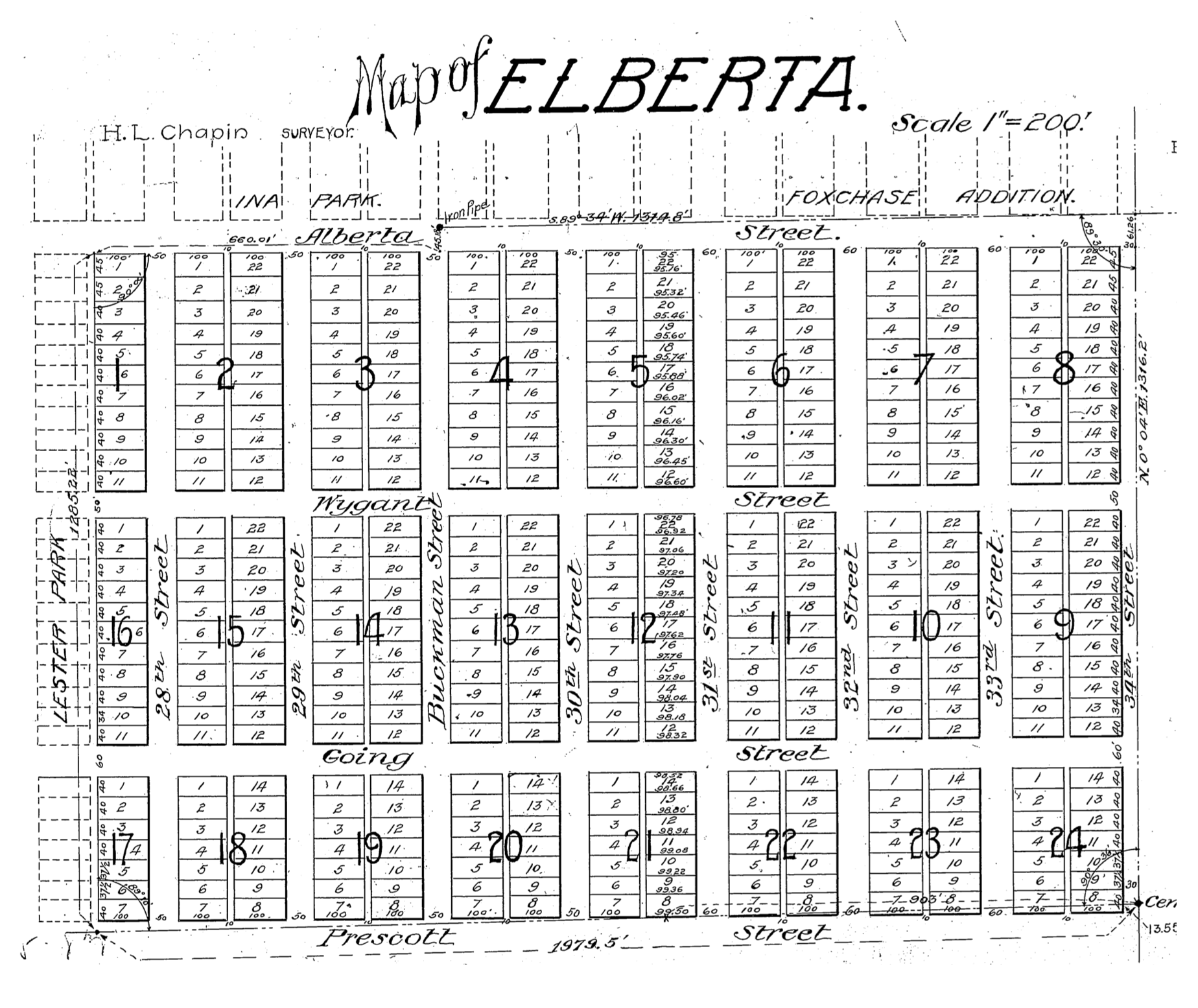
We’ve been looking into the Elberta Addition this week, a 24-block subdivision platted in August 1906 bounded by Northeast 33rd and 28th on the east and west, and by Northeast Alberta and Prescott on the north and south.
It’s a name that has caused some confusion in the past given its proximity to Alberta Street. Readers will recall that name stems from the fourth daughter of Queen Victoria, Princess Louise Caroline Alberta, an honorific street name bestowed in the 1880s. Not to be confused with Elberta.
Elberta was once the most popular variety of peach, named for the wife of the Georgia peach grower who established the hybrid in the 1800s. It’s rich, tart flavor eventually fell out of favor to sweeter varieties, and what had been tens of thousands of acres of peach orchards all across the country were uprooted. Our peach sources tell us that finding an Elberta peach today can be challenging.
This 50-acre subdivision, part of today’s Concordia neighborhood, was once forests, orchards and fields, part of the Buckman Estate and may well have known its own share of Elberta peaches. But when real estate speculation boomed in Portland after the 1905 Lewis and Clark Exposition, properties like this became valuable for conversion to residential use.
Angeline B. Richardson, sister of Isaac Buckman, owned the property (and many other properties on Portland’s eastside) and when she saw the writing on the wall for the rapidly increasing development value, she platted the fields into 479 lots, each 40 x 100, and began selling them off, with the help of her friends Thomas Benton Potter and H.L. Chapin.
From the Oregon Journal, August 5, 1906
Potter and Chapin were the principals of a much larger real estate syndicate that developed rural properties in Kansas City, San Francisco and even on the Oregon Coast: Potter was the driving force behind the ill-fated Bayocean community west of Tillamook that was eventually washed away by the Pacific Ocean. They also initially sold most of the lots in the adjacent Ina Park, Lester Park and Vernon subdivisions here in Northeast Portland.
About 1906, the Potter & Chapin firm changed its name to the Arleta Land Company (which just to keep things interesting, The Oregonian sometimes confused with the Alameda Land Company), named for Thomas Potter’s youngest daughter Arleta. The firm continued to develop and sell properties across Portland’s eastside, including in the Mt. Scott – Arleta neighborhood which it platted in 1903. The Arleta Land Company kept a fairly low profile, unlike other developers who paid for robust advertising campaigns in local newspapers. Arleta Land Company’s presence was almost entirely focused on classified advertising where business was brisk in 1906-1908 with news of properties being bought and resold, and homes built.
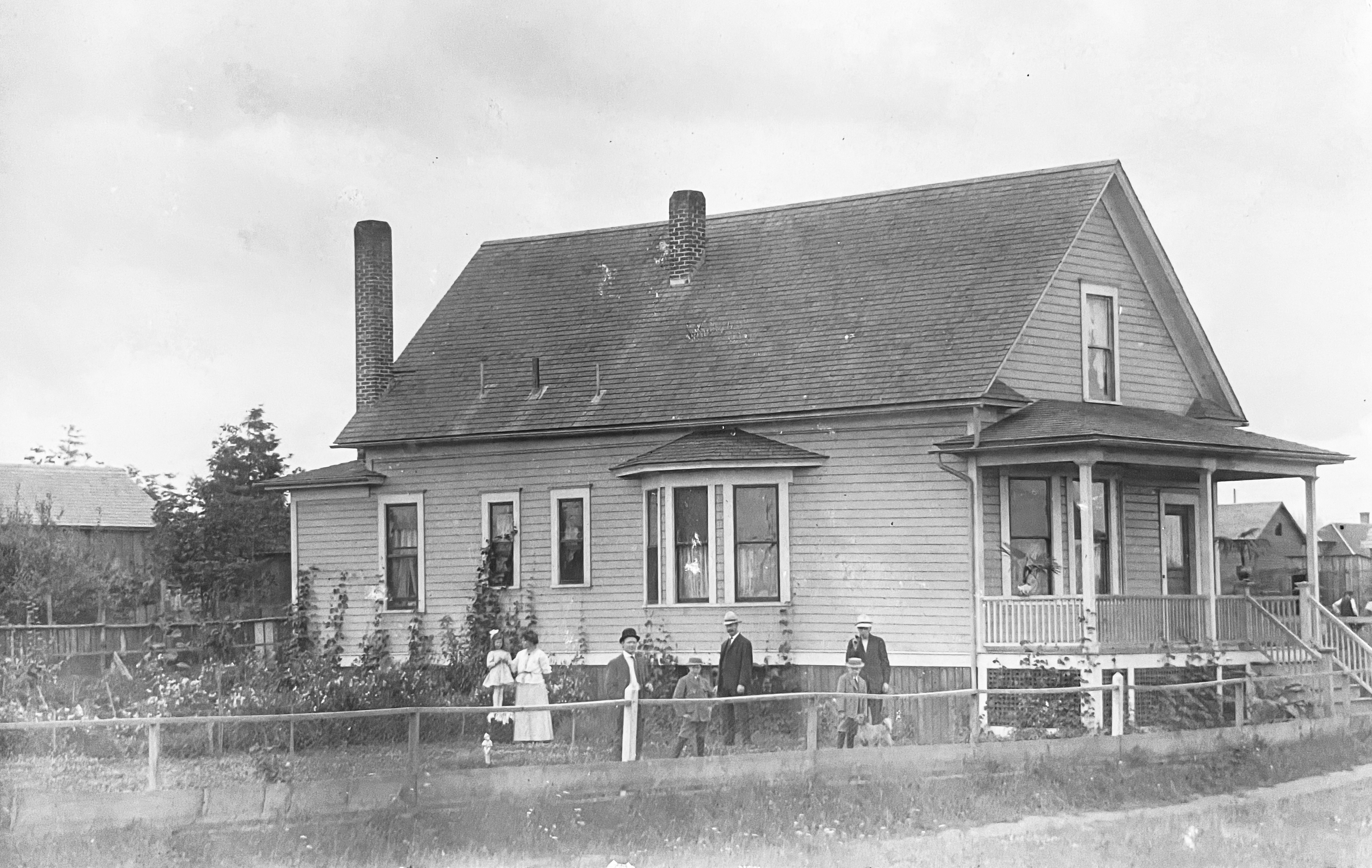
In other research, we’ve come across an interesting photo of the young Elberta Addition, showing the former home of the Hans C.S. and Minnie von Homeyer family, located at the southwest corner of NE 27th and Going. Click into this photo for a good look, it’s a beauty.
Southwest corner of NE 27th and Going, known as 850 Going Street prior to the Great Renumbering.Courtesy von Homeyer Collection
Today a 1910 Victorian-style home known as the “Going Queen” is on that property. But back in 1907, the von Homeyers bought the two lots from the Arleta Land Company for $350 and built this house. Unfortunately for them, fire destroyed their home on July 28, 1907. This rich photo has many stories to tell, and reminds us of the rural nature of the area.
Today, Elberta is a great place for a walk to appreciate residential design and construction from the first decade of the 20th Century. We’ve enjoyed exploring Elberta in this post about its alleys, which are like a built-in trail system for many of us dog-walkers. And in this bit of photo sleuthing.
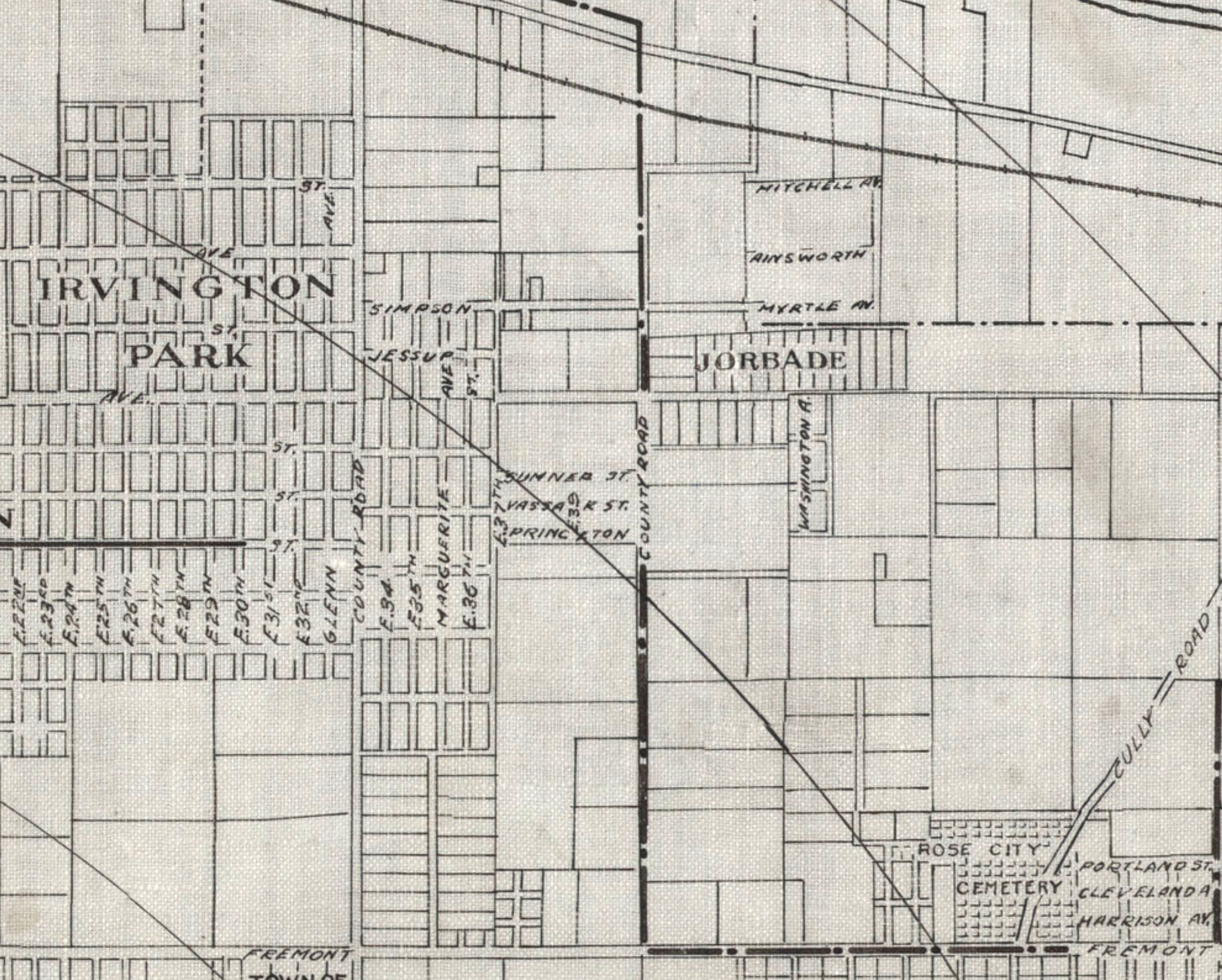
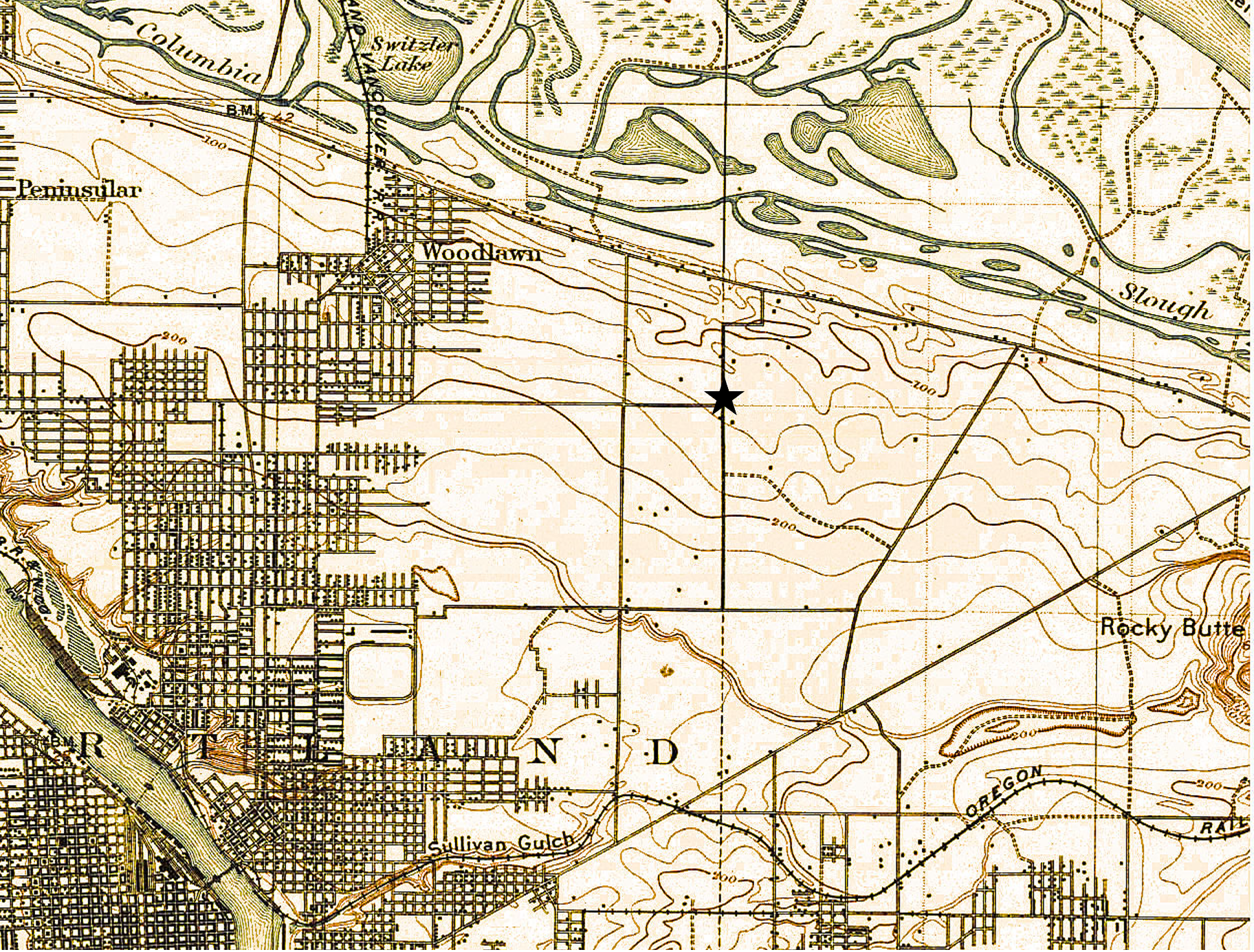
Detail from a 1908 Portland Railway, Light and Power Map showing the vicinity of 42nd and Killingsworth, in the center of the image. The Jorbade subdivision was platted at the intersection in 1908. The western “County Road” is today’s NE 33rd. The eastern “County Road” is NE 42nd. Rose City Cemetery appears in lower right (note that Cully passes through the cemetery).The cross-hatch lines indicate mile increments distant from downtown.TheIrvington Park plat is part of today’s Concordia neighborhood.The Alameda Park Addition had not yet been platted and is shown as open fields.
Continuing from our first installment exploring the layers of history at NE 42nd and Killingsworth…
The early years of the 20th Century brought a sea change to the Portland area: dramatic growth in population and a spike in residential and commercial construction that followed; a steady increase in the area’s rail and river shipping and port activity; extension of an interconnected electrified streetcar system; and arrival of the automobile. The 1905 Lewis and Clark Centennial Exposition drew national and international attention to Portland, attracted business and new residents, and set Portland on a growth curve that would remake the region.
During those early years, the vicinity of NE 42nd and Killingsworth was still a rural crossroads. Killingsworth (which was gravel) didn’t go farther east: it dead-ended into NE 42nd Avenue, which was known only as “County Road” up until the late 19-teens. Maps show the area much like the 1897 USGS map until the second decade: fields all around and less than 30 buildings—many of them barns—within a one-mile radius of the intersection.
But real estate speculators and some landowners could see the writing on the wall. Streetcar lines were working their way east, and new subdivisions and commercial areas were being planned and built. By 1912, a high volume of residential construction was underway in nearby Alameda, Beaumont and Rose City, all of which had been similar open fields and dirt roads.
Open lands are platted for homes, setting the stage for the area we know today
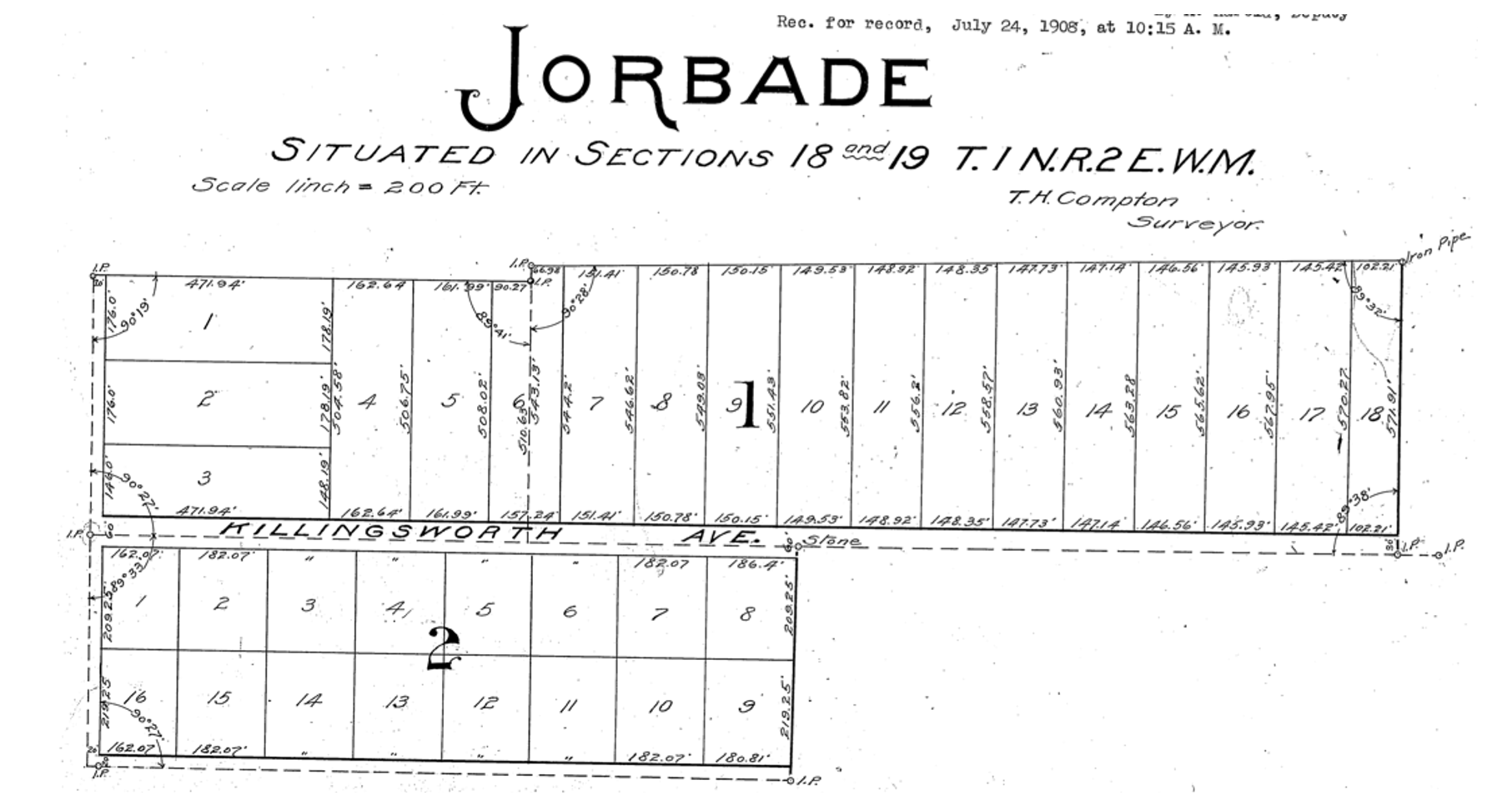
By 1909, real estate speculators Commodore Perry Jordan and Theodore August Garbade had purchased a portion of the old Isaac and MaryAnn Rennison Donation Land Claim at the intersection of today’s NE 42nd and Killingsworth. The two planned to sell residential building lots from what had been open farm land. Jordan and Garbade called their planned suburb “Jorbade,” and filed this plat with Multnomah County. The western edge of the plat is NE 42nd Avenue. Important to note that Killingsworth wouldn’t go through for at least 10 more years. These lots would be just that–vacant lots–for many more years.
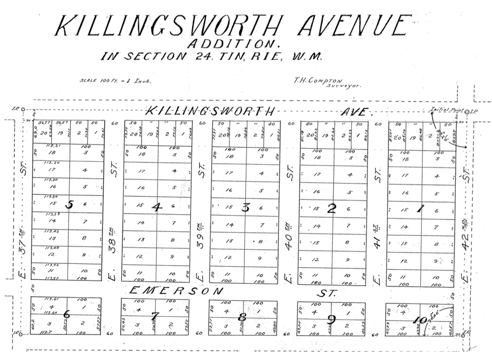
A few years later Jordan and Garbade acquired the lands on the opposite corner and were ready to convert them too from open fields to a subdivision. In 1911 they platted the Killingsworth Avenue Addition, from Killingsworth south beyond Emerson, between NE 37th and NE 42nd.
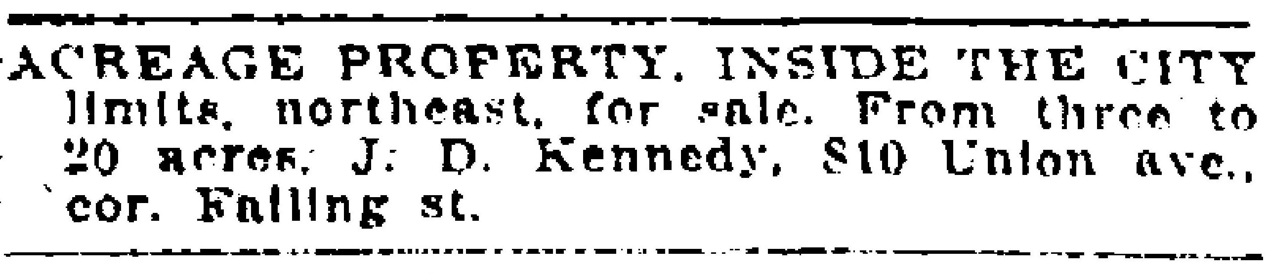
A bit farther west, local resident and real estate speculator John D. Kennedy was a few steps ahead of Jordan and Garbade. He had bought old homestead lands in 1880 believing that Portland would one day expand east; in 1890 he platted the Kennedy Addition, while this area was still part of its own town: East Portland. Here’s a detailed look at Kennedy and his adjacent nearby lands.
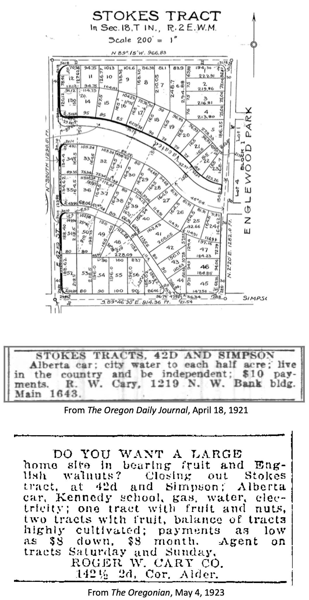
The Stokes Tract followed Jorbade and the Killingsworth Addition in 1920, north of Killingsworth and east of 42nd, establishing the graceful arc of Ainsworth and Simpson Court. This area retained a rural feel: “Live in the country and be independent” reads the advertisement.
Other subdivisions followed including tiny View Park in 1923, on the north side of Killingsworth between 36th and 40th:
Interest in these planned subdivisions was not particularly strong until the late 1930s: their distance from downtown, their presence outside the city limits and about a mile walk from the nearest streetcar line (despite what the advertisement said about being on a 5 cent fare line); their rural nature including gravel roads and surrounding fields and orchards may have made them less attractive, even if the prices were lower. But as Portland continued to expand, and the automobile became more prevalent, would-be homeowners were ready to buy and build.
Classified advertisements for properties adjacent to the intersection report a variety of crops growing at the time: orchards of Bing, Lambert and Royal Anne cherries; English walnuts; Bartlett pears; prunes and plums; apples; rows of strawberries and raspberries.
Often referred to as “truck farms” because the produce was trucked to market (and some of it was sold out of the back of trucks at busy intersections and small markets around town), these surrounding fields produced fruit and vegetables for Portland households. One farm near the corner of what is today’s NE 41st and Holman was owned and run by a Japanese immigrant family, as were others in the area. During WWII, Japanese farming families across the Pacific Northwest were removed from their land and placed in internment camps in southeast Oregon, central California, Idaho, Utah, Wyoming and Colorado.
Portland Air Base leads to new roads and new residents
By 1935 air freight and airline passenger traffic had overwhelmed Portland’s first airport—located on Swan Island—and the city spent $300,000 to purchase a 700-acre site adjacent to the Columbia River where today’s Portland International Airport resides. With a grant from the Works Progress Administration, workers drained the former floodplain and dumped more than 4 million cubic yards of sand across the site. The airport opened in 1941. During the hundreds of generations of indigenous presence prior to European contact, these wetlands had been both seasonal home and food source.
Following declaration of war in late 1941, Army Air Base operations at the site were dramatically increased and Portland became a regional magnet, attracting tens of thousands of workers and their families to multiple war-related industries across the Portland area. An immediate demand for housing, combined with a newly-improved road network and the availability of open land in this area so close to the airbase, fueled interest.
A small expression of the interest was a long row of connected cabins dubbed the “tourist cabins” and an adjacent business called the Spur Tavern at the northeast corner of NE Holman and 42nd avenue. Built in 1942 as temporary housing for the great influx of people, the residences and tavern became a landmark of sorts. Read more about the Tourist Cabins and the Spur.
City buys old farms to create Fernhill Park
After voters approved a property tax levy in 1938 to create more parks and playgrounds for a growing Portland, the city set out on a 10-year process of buying the hills and gullies northwest of 42nd and Killingsworth, starting out in 1940 with a 10-acre parcel owned by the Jackson family right in the middle of it all.
Prior to acquisition, several dirt roads criss-crossed the north side of the area, one even ran right up the bottom of the gully at the heart of today’s off-leash area in the northeast corner of the park, pausing at a wide spot that served as a dump and debris field where car bodies and all manner of junk were strewn.
It wasn’t an official dump, but more like a secluded out-of-the-way place where residents from the surrounding area dumped unwanted items. In the late 1930s and early 1940s, when the NE 42nd Avenue connection to Columbia Boulevard was built, some of the dirt fill needed to make the grade change for the overpass was dug out from and supplied by the gully on the east side of the park along today’s NE 41st Avenue.
As the park took shape through the late 1940s and early 1950s, some locals referred to it as Ainsworth Park, a name that appears frequently in real estate advertising of that era. By the early 1950s, most of the open land to the north of the park had been converted to subdivision (the Vanlaeken and Leitritz plats). NE Highland Street was put through the middle of working farmland as the area was transformed into suburbia. By June of 1951 when most of the park buying was done, the city had invested $60,479 total for all of the parcels and had acquired 25.95 acres. Read more about the origin of Fernhill Park.
Aerial photographs = time travel
As a reward for reading this far, and as preface for the next installment, here’s a series of aerial photos that allow us to witness change. Each of these is fascinating, so click in for a detailed view. Observations follow each image. Aerial photoscourtesy of the University of Oregon Map and Aerial Photography Library.
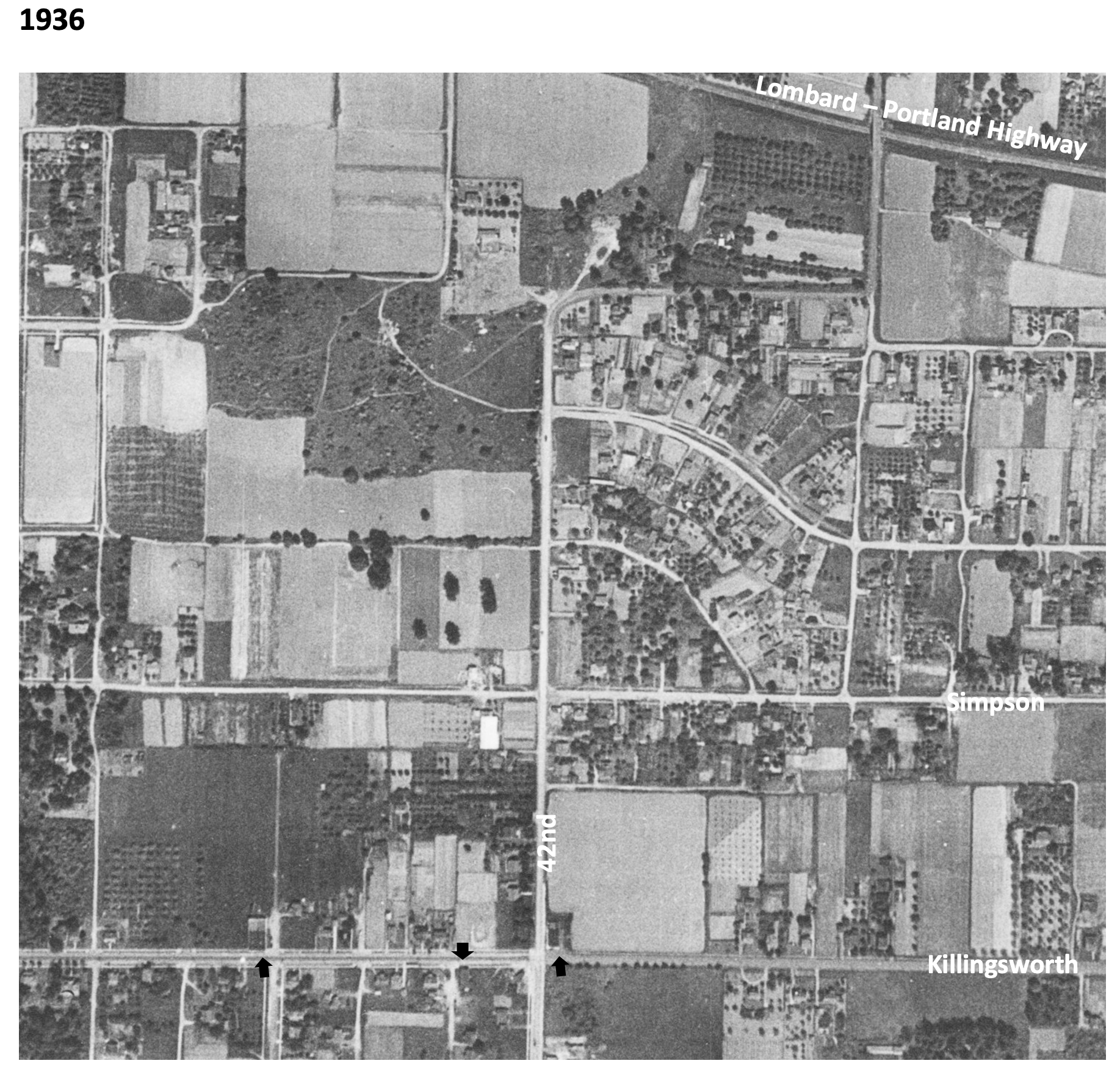
In 1936, the unplowed lowlands of today’s Fernhill Park show up just left of center, and the arc of Simpson Court and NE Ainsworth feed into NE 42nd. No viaduct yet over Portland Highway. The arrows indicate locations of three small mom-and-pop groceries. Note that Simpson goes through east-west, across the middle of today’s Fernhill Park.
In 1939, more houses are showing up, and orchards in the center of the photo are maturing.
In 1948, the 42nd Avenue viaduct is in place (not pictured) connecting NE 42nd to the new Portland Airport. Houses continue to replace open fields. The greenhouses at Knapps Nursery appear west of NE 42nd at Simpson.Orchards near NE 37th and Killingsworth are replaced by homes.
In 1951, a trailer park appears at the NE corner of 42nd and Killingsworth in what were once open fields. Significant new home construction is evident north of Killingsworth and west of 42nd. The flat playing field at the south end of Fernhill Park begins to emerge from the former agricultural fields north of Simpson, and west of 42nd.Construction is underway on the new St. Charles Churchand school.
In 1961, the trailer park is replaced by a large Safeway store and parking lot at the corner of 42nd and Killingsworth, which opened in 1957. A baseball diamond is clearly visible in the new Fernhill Park. Orchards and open agricultural fields are gone.Simpson still goes through west of Killingsworth.South of Simpson in this area, 26 homes, three duplexes, a PGE power substation, and Knapp’s greenhouses and nursery are soon to be demolished or moved–over the strenuous objection of neighbors–to make way for John Adams High School.
In 1971, John Adams High School is in place, replacing a portion of the open areas of Fernhill Park and most of the homes between Killingsworth and Simpson west of 42nd. Simpson no longer goes through west of 42nd. Acres of parking are available west of the Safeway storeat 42nd and Killingsworth.
By 2020, John Adams High School (later known as Whitaker Middle School) was demolished in 2006, but the track remains. Neighborhood street tree canopies are filling out.Safeway is closed and the buildings at the northeast corner of 42nd and Killingsworth are now gone.
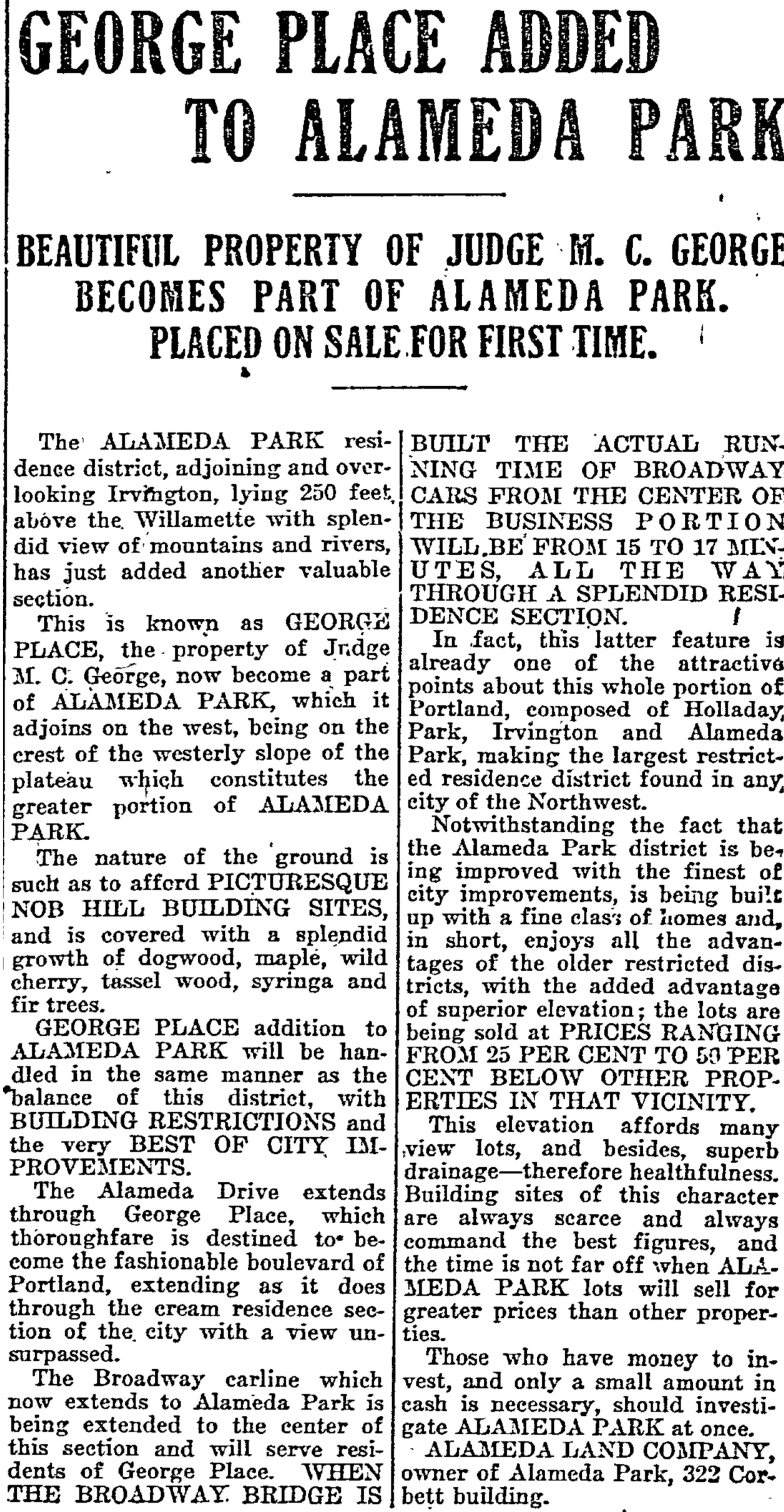
Like a mosaic of fine old tiles, hundreds of subdivision plats rest atop Portland’s neighborhood landscape, creating a base-layer of orderly streets and lots beneath the places we know today. Drawn up over the last 140 years by different developers, each plat has a name: some are catchy, some are descriptive, a few remain in common use to describe the places we know. Most have been lost to time, like George Place.
We’ve written about most of the underlying Alameda plats here and for a series of recent stories in the Alameda Newsletter: Gleneyrie, Olmsted Park, Homedale, the Pearson Addition, Waynewood (which was remade from the labyrinth created by six of the original plats), not to mention the nearby Kennedy Addition, the distinction between plats and neighborhood boundaries, and many other plats on both sides of the Willamette. There’s even a plats category here on the blog if you are inclined to a deeper dive.
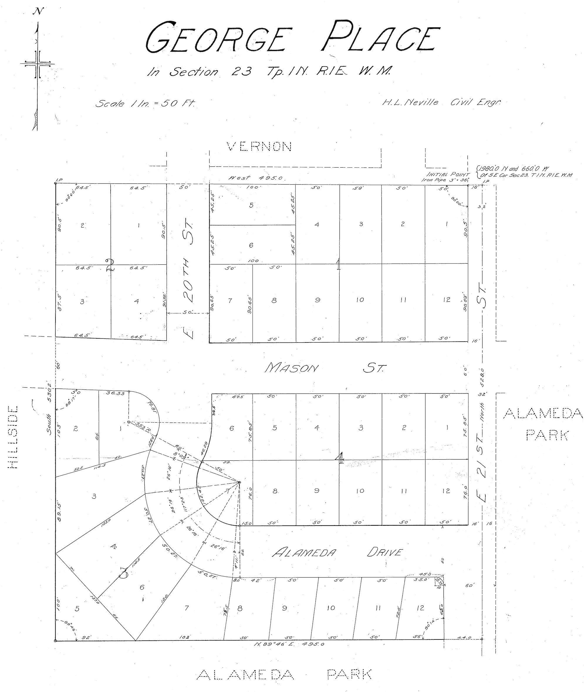
In this parade of plats, we should make sure one of the smallest ones doesn’t get away: George Place, a tidy square of 40 lots where grid meets slope at the far southwest edge of the Alameda Plateau. Take a look:
Namesakes Judge Melvin Clark George and Mary Eckler George traversed the Oregon Trail with their families as children and grew up on homesteads in the upper Willamette Valley. They married in 1873 and Melvin was soon elected to the Oregon State Senate (1876-1880), and then to Congress in 1881, where he served two terms before returning to Oregon to teach medical law at Willamette University (1885-1889). He served as Multnomah County Circuit Judge (1897-1907) and retired from the bench at age 58 to become director of public schools in Portland.
Melvin George, circa 1900
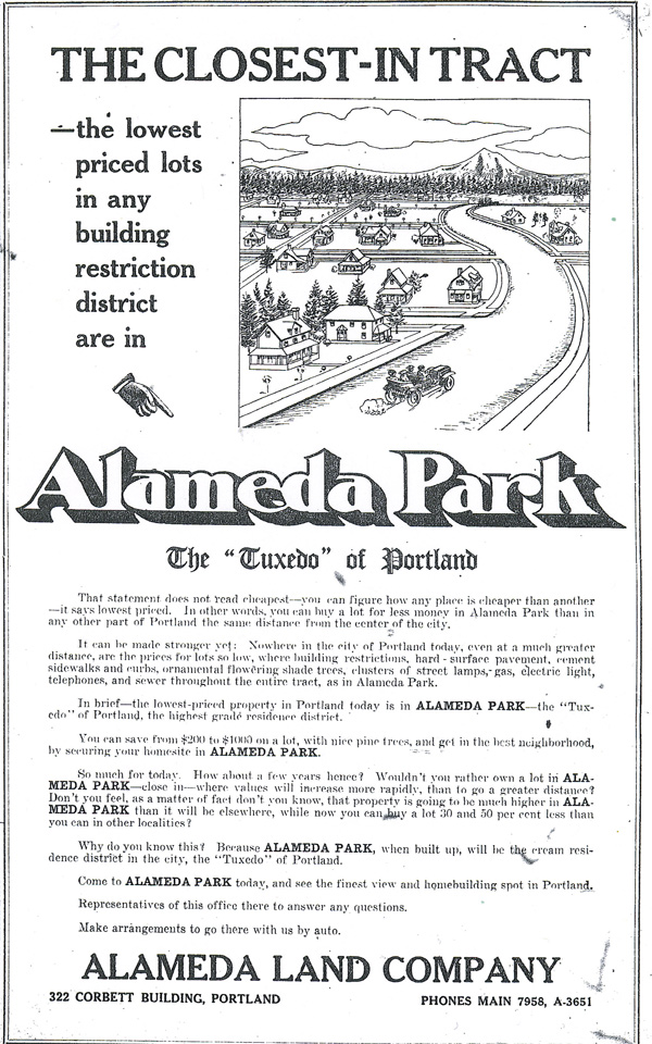
Sometime around the turn of the 20th Century, seeing development potential on the horizon (literally), the Georges purchased six acres atop the ridge. They filed the George Place plat with the Multnomah County Surveyor on April 25, 1911, two years after the Alameda Land Company platted the Alameda Park Addition which anchored their eastern flank.
At the time, the Alameda Land Company was blitzing The Oregonian and the Oregon Journal with advertisements stirring excitement for the much larger Alameda Park Addition. Agreements were evidently made and Alameda Land Company took over marketing the property, dedicating one full advertising panel to the topic in June 1910.
From The Oregonian, June 4, 1910
Of course in 1910, all of these places were still purely imaginary: the plats may have been filed or on the drawing board, but streets were just being carved out of the gravel, trees felled, stumps removed. In 1910, it was still a giant brush patch, with orchards and dairies down on the flats below.
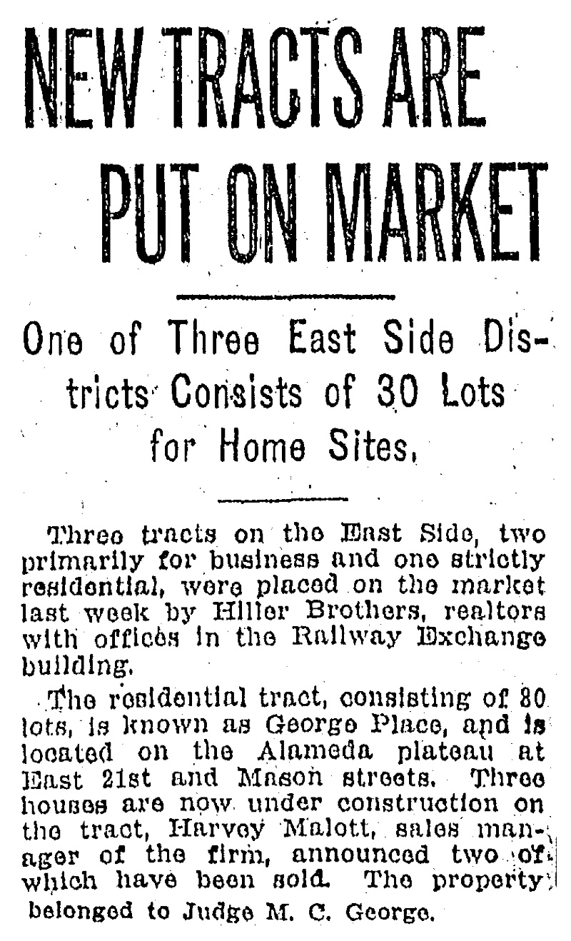
Lot sales and homebuilding were slow to catch on in George Place during these first years. Streets and infrastructure were in place by the mid-teens, but Portland’s economy began to cool in the run up to World War I. A few lots did sell, but the George Place six acres remained mostly unbuilt until the early 1920s, when a new real estate and homebuilding company known as the Hiller Brothers Company bought the lots and started building into a fast improving real estate market. By the way, this is one of the things we love about paying enough attention to a particular place: pretty soon everything you bump into starts to connect (see our profile of Hiller Brothers on The Builders page).
From The Oregonian, March 28, 1926. Not sure where the reporter got 80 lots, you can count the 40 lots in four blocks on the plat above.
In 1926, the streets were still gravel, but three houses were under construction including the one with the best view, for company owners James and Sarah Hiller at 2024 NE Alameda Drive. Hiller Brothers built many of the homes here, using plans provided by architect Hubert A. Williams. English cottage style was clearly the most popular. The Great Depression paused homebuilding activity leaving multiple vacant lots in George Place that finally filled in during the 1940s and early 1950s.
As for the Georges, they raised their family in a comfortable house up the hill on Market Street in southwest Portland’s Goose Hollow, with no evidence in newspaper coverage they ever lived on or paid much attention to George Place on Alameda Ridge. Melvin died at age 83 on February 22, 1933. Mary lived on to age 91 and died on September 24, 1942. They are buried together in Lone Fir Cemetery.
Plats are the puzzle pieces of our urban geography: invisible grids tied to a much larger grid known as the Willamette Meridian; part engineering plan, part map, part marketing pitch. Developers were required to submit them to the Multnomah County Surveyor’s Office before they divvied up the landscape. Today more than 900 individual plats make up the City of Portland. Knowing this provides a passport into the city’s development history.
But sometimes, the ones that don’t get developed are as interesting as those that do.
A recent research assignment took us up Cornelius Pass Road into the northwest reaches of Portland’s west hills, high above Sauvie Island in pursuit of the story of Folkenberg School, a 1913 Craftsman-style one-room building that operated for 23 years until the Great Depression and school consolidation forced its closure.
Folkenberg School in May 2024, courtesy Alan Baylis, RE/MAX Advantage Group, and REPIXS.
Leaning on our research, Portland Monthly just wrote a nice piece about the old school, which was converted to a residence in the early 1970s and recently placed on the market.
The simple school—built without indoor plumbing, heated by woodstove and lighted by tall windows that flanked the single large room—existed at the center of the Folkenberg Addition, a 51-block planned community that its developers dreamed would one day be an extension of Portland.
Portland experienced a land rush in the years after the 1905 Lewis and Clark Exposition, which attracted 1.5 million visitors, many of whom liked what they saw and wanted to stay. Much of Portland’s eastside was developed during this time, with new neighborhoods being platted every month, carved out of agricultural and forest lands. Real estate speculators made fortunes as lots were measured out, entire neighborhoods established and homes built.
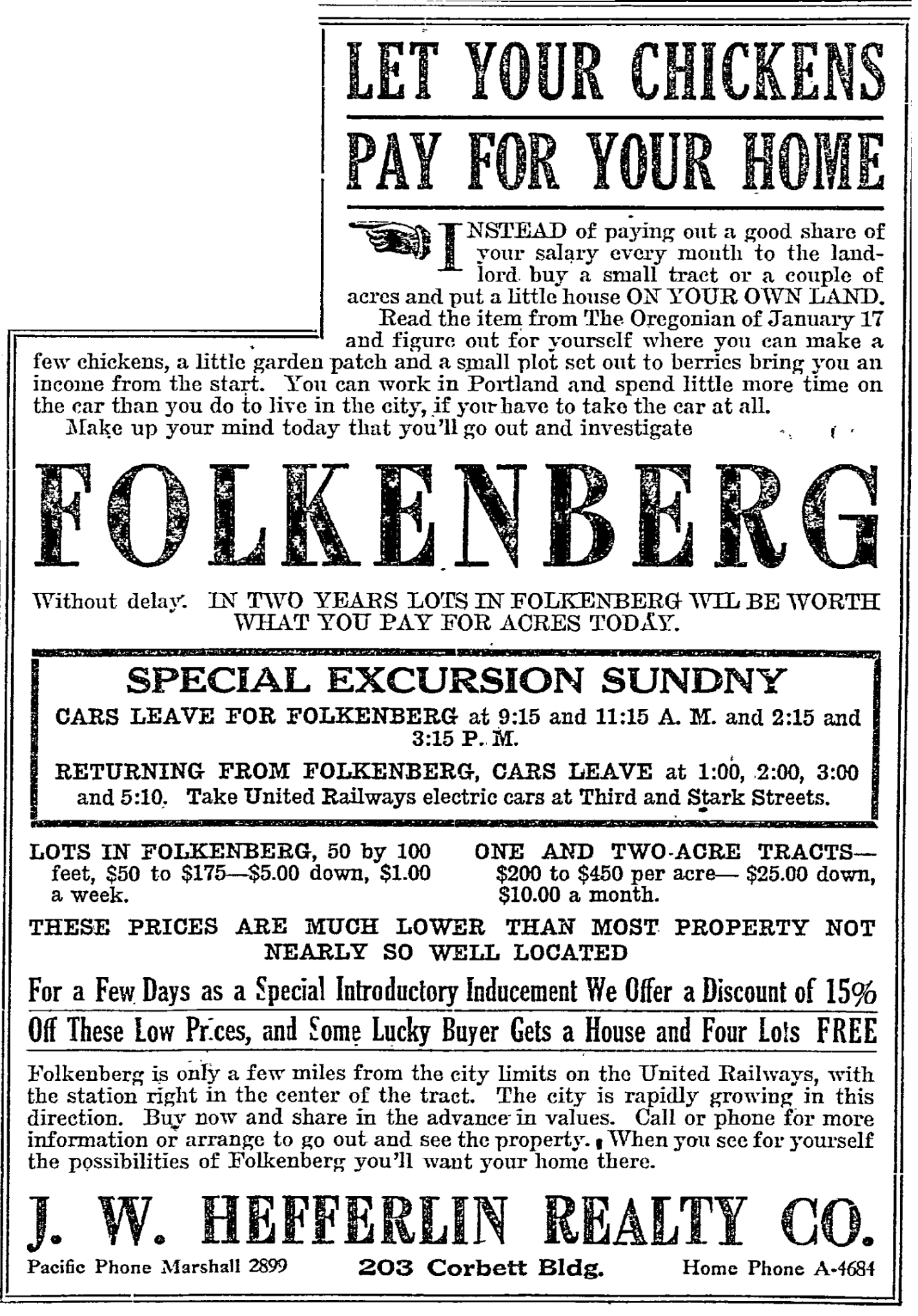
That same housing boom fueled interest in other undeveloped lands within striking distance of downtown. When he filed his plat for the Folkenberg Addition in January 1911, realtor and land speculator R.W. Hefferlin was probably thinking about the newly built Heights neighborhoods of Portland’s westside—Willamette Heights, King’s Heights, Arlington Heights, and Hillside. Still, he recognized the reality of the surrounding rural landscape and in fact promoted the revenue generating aspects of chickens, fruit trees and nearby fields.
Folkenberg Plat, 1911. Click to enlarge.Red box indicates location of Folkenberg School. Cornelius Pass Road is at far left. The wide arc sweeping through north-south is the United Railways line.Nearby were other plats with similar ambitious planned developments.
In February 1911, United Railways completed a 4,103-foot railroad tunnel through the hillside, making a graceful arc right through the heart of Folkenberg and connecting the Tualatin Valley with Portland. Hefferlin made sure there was a rail passenger platform built in Folkenberg, and even named one of the improbable roads Depot Street to make sure everyone knew about the rail link. Remember, in the time before widespread use of automobiles, connecting subdivisions to Portland by rail was the number one factor ensuring property sales.
The namesake Folkenbergs were a Norwegian immigrant family who worked 300 acres in this area and ran a small sawmill. Patriarch Louis Folkenberg died unexpectedly in 1892 at age 54 leaving wife Inger Maria and 10 children, ranging in age from three to 24. By 1911, with children fledging and needs changing, the family sold off 107 acres for $14,455 to developer Hefferlin, who divided it up and began selling lots.
From The Oregonian, January 25, 1911. The home Hefferlin advertised as giving away free was the 1880s farmhouse built by Louis and Inger Maria Folkenberg.
When he platted Folkenberg, Hefferlin was already in the process of platting and marketing other nearby subdivisions known as Bayne Suburban Farms and Thompson Gardens, which were joined by other adjacent planned subdivisions called Sheltered Nook, Ingleview, Greenoe Heights, Cornelius Park, and Plain View Acres.
In 1913, the arrival of a few new families, and hopes for many more—plus the presence of many young Folkenbergs—eventually led to the call for a school to serve the area. Previously, children from this area traveled down the hill by foot or horse and wagon to Holbrook, Burlington or Linnton for schooling.
At its peak in 1916, the school had 33 students. But by the early 1920s, it was becoming clear J.W. Hefferlin’s suburban vision for Folkenberg was not going to pan out. Property sales slowed and then stopped. United Rail Lines focused on freight, not passengers. The area, as it turned out, was not within easy striking distance of downtown and in fact the people who wanted to live here were not particularly interested in things related to city life.
In the late 19-teens, Hefferlin stopped paying property taxes on the remaining lots he was trying to sell. Then in the summer of 1923, he gave up all together and moved to Los Angeles.
Through the late 1920s and into the Great Depression of the early 1930s, school enrollment slumped. In 1936, with enrollment down to just six students, parents in the area voted to close the school, sending the remaining kids to Holbrook School down the hill on Highway 30.
Folkenberg and its neighbor plats, conceived at a time of optimistic growth, remained the mostly rural lands they are today. The plats became ghosts, just lines on a map. The tax lots are still there, rolled together now into larger holdings. But Hefferlin’s idea of the next-big-thing westside neighborhood fled with him to Los Angeles, leaving behind a deserted old school tucked into a hilly rural landscape that faced years of hard use and deferred maintenance until new owners came along in the early 2000s to bring it back to life.
Today, we think of the Alameda neighborhood as one contiguous area with well-recognized boundaries: The city’s Office of Neighborhood Involvement identifies Alameda as that area from Prescott on the north to Knott on the south; from NE 21st on the west to NE 33rd on the East. One single named neighborhood today, containing about 2,400 dwellings and more than 5,000 people.
But hiding underneath today’s one single map is a treasure of 23 old maps—subdivision plats—all drawn at different times by different people as they transformed this landscape one small piece at a time from forests and fields to the grid of streets we know today. We’ve been taking a systematic look at these plats, some of which like one particularly chaotic collision just north of Knott, we’ve written about.
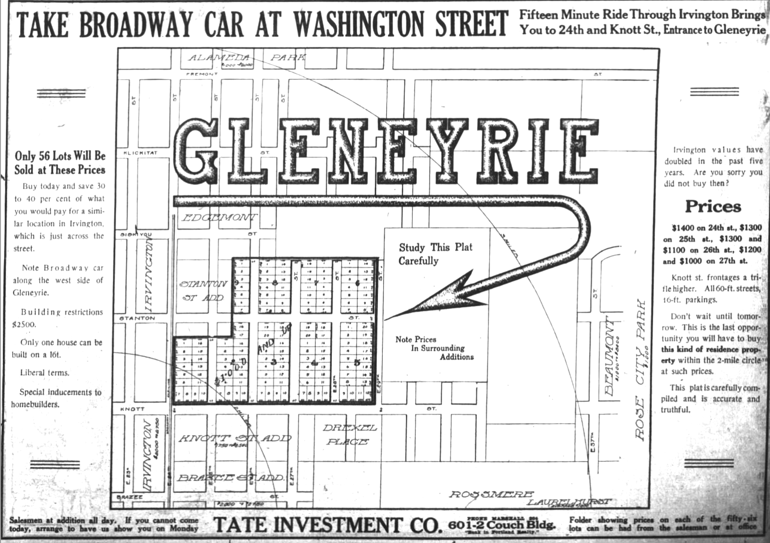
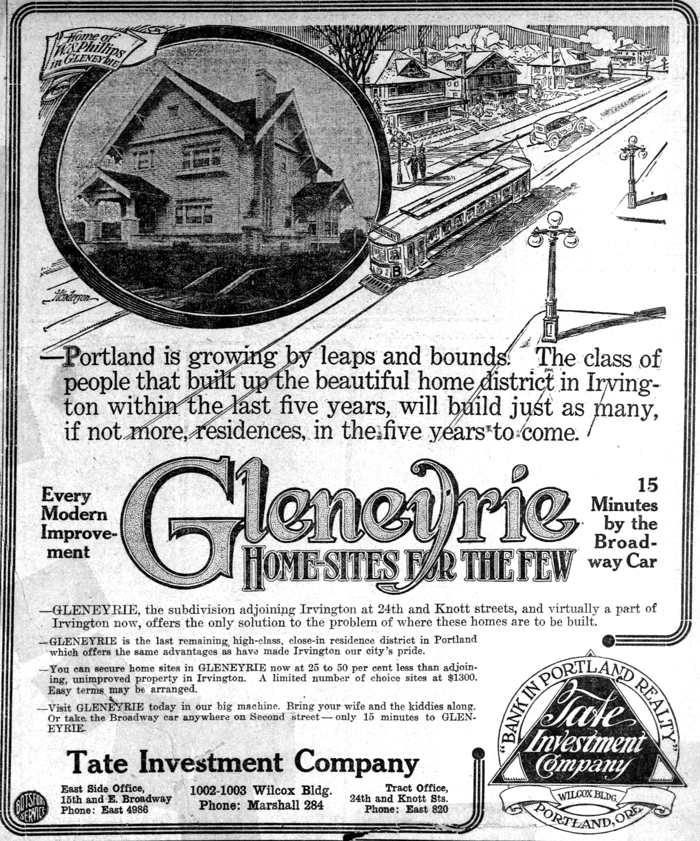
Here’s one we’ve been looking into recently: Gleneyrie, a subdivision plat filed in July 1911 by three couples who were the principals of the Tate Investment Company: Thomas and Inez Foster; Jost and Maria Held; and Robert and Nellie Tate. That fall, they placed their first ad for the property, below, which was then still just a concept (click in for a larger view).
From The Oregonian, October 22, 1911
The Tate Company investors purchased their 24 acres of the former Bowering Homestead Donation Land Claim in the years after the 1905 Lewis and Clark Exposition with an eye toward real estate development. The surrounding open fields, orchards and dairy property were rapidly being converted to residential use to keep up with Portland’s booming real estate market and population. And there was much money to be made by investors ready to speculate on a rising market. The Tate Investment Company also developed Dixon Place, another plat just north of Fremont between NE 15th and NE 21st avenues.
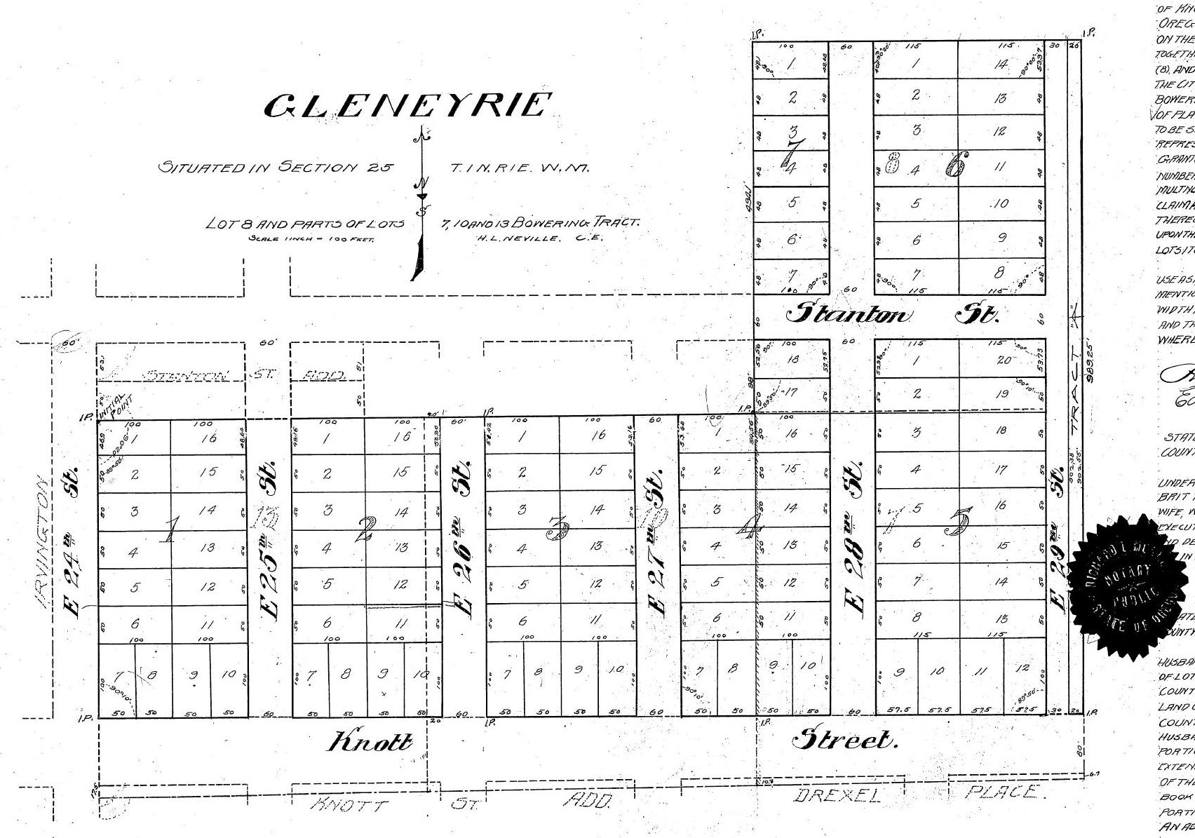
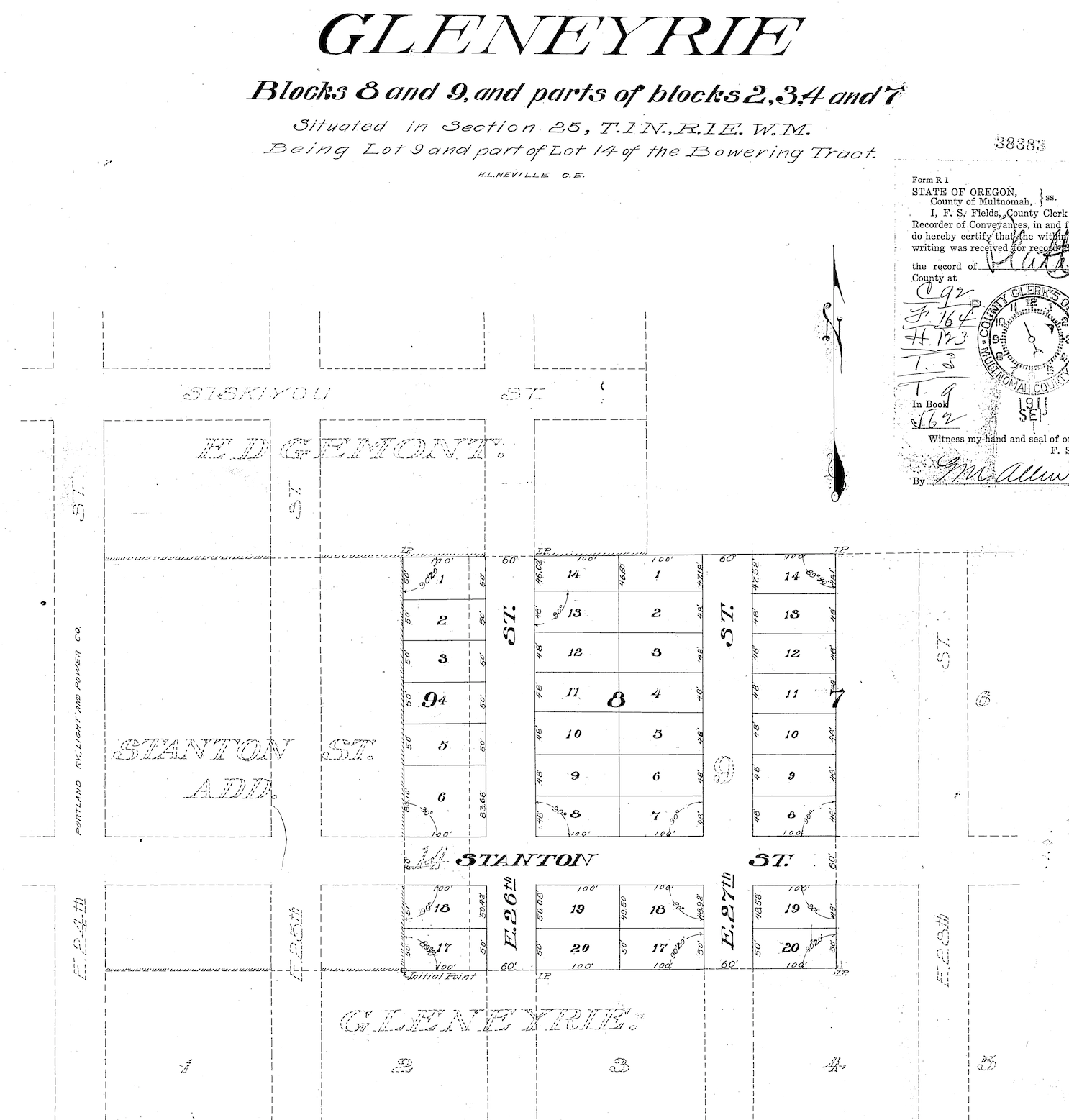
Here’s a look at the official Gleneyrie plat, filed with the Multnomah County Surveyor and County Clerk on July 25, 1911: from NE 24th to NE 29th, between Siskiyou and Knott.
One week later, Tate added additional area to Gleneyrie taking in East 26th and 27th north to the existing boundary on the eastern edge of the plat.
The namesake Gleneyrie was a Tudor-style castle in Colorado built in 1871 by William Jackson Palmer, founder of Colorado Springs: big, beautiful, fancy and well-known. And the name sounded good too, which was key. By 1915, Portland developers had filed more than 900 plats—development plans that divide an acreage into a subdivision of lots and streets—many of which were as small as one block or less, and all named by developers searching for an attractive sounding name.
Today’s Alameda neighborhood is made up of 23 separate plats, all filed at different times by different developers who were competing with each other and speculating on market conditions when they bought chunks of what had been old homesteads and farms claimed in the 1850s and 1860s.
In some areas the plats have retained their distinct personality and name. But here in Alameda—named for the 1909 Alameda Park Addition plat filed just to the north—the identity of the individual plats like Gleneyrie eventually dissolved into the commonly used neighborhood name we know today.
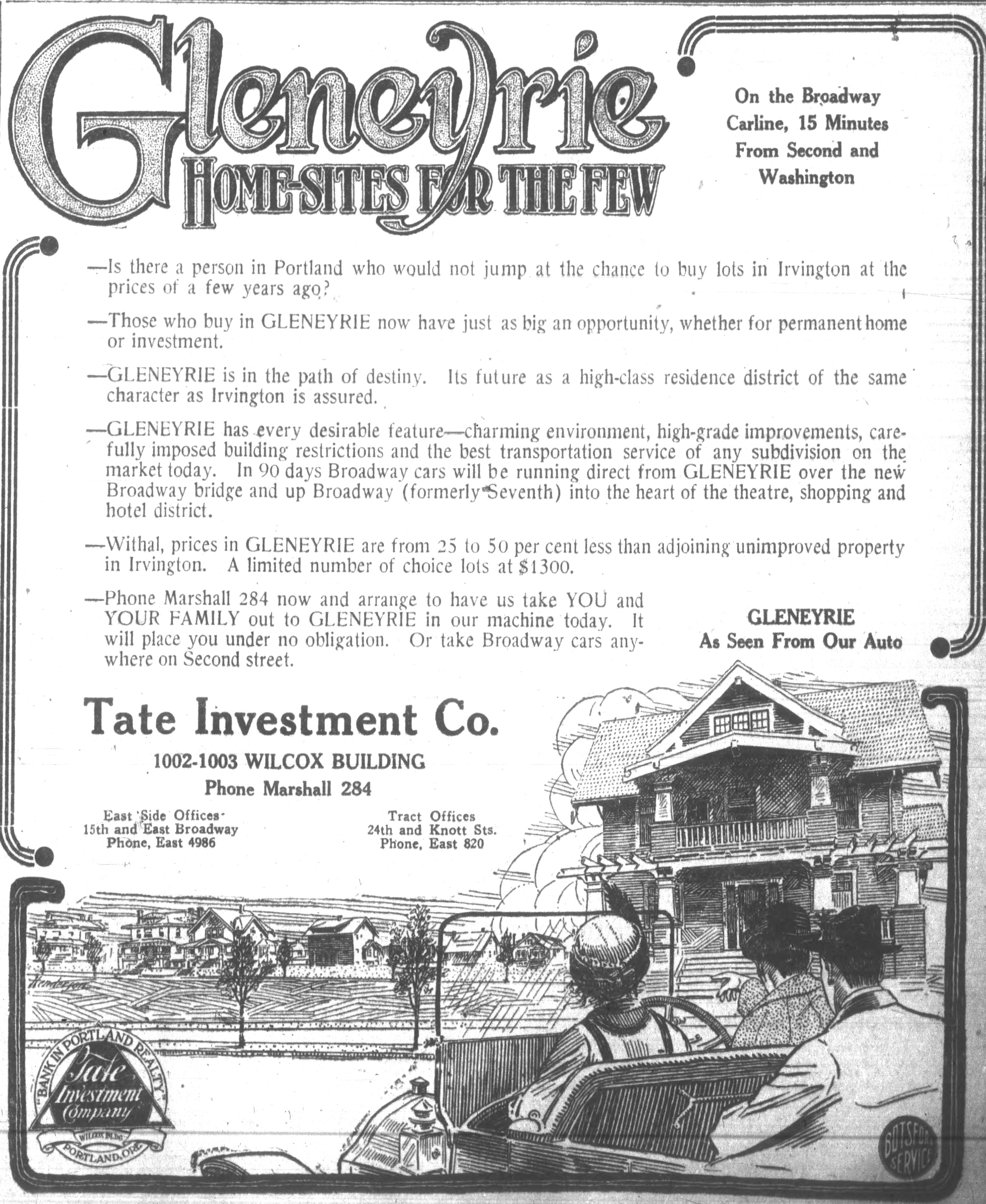
But in the Spring of 1913, when having a catchy name might help compete with all the other real estate advertising, the Tate Investment Company pushed out a series of full-page and half-page illustrated ads in The Oregonian and the Oregon Journal to market the attributes of their new subdivision. And they tied their marketing more closely to Irvington—a well established prestigious brand—than to Alameda, which had just been launched (and was trying to coattail on Irvington as well).
From The Oregonian, April 14, 1913
From The Oregonian, April 20, 1913
While all this advertising was underway, work out on the ground of what was Gleneyrie transformed the property from what were rolling fields into a mostly level subdivision. Significant grading work was done on the property to remove hills and fill in swales and ponds. Newspaper accounts from 1913 indicated 50,000 cubic yards of fill was removed: that’s more than 4,000 modern-day dump truck loads.
One of the leading early builders in Gleneyrie was Arnt Anderson, one of the two-dozen-plus builders we’ve written about on The Builders page. Anderson built some amazing homes that have passed the test of time…before he was arrested, convicted and imprisoned for grand larceny.
Today, ask anyone to tell you where Gleneyrie is and you’ll probably get a blank stare. But back in the day, the folks at the Tate Investment Company were trying hard to make it a household name. Literally.
Wondering about the other 22 plats in today’s Alameda? Here’s the full list: Alameda Park, Homedale, Olmsted Park, Irvington, Edgemont, Pearson’s Addition, Town of Wayne, Town of Wayne Replat, Waynewood, Irvingwood, Meadow Park, Dunsmeade, Irvindale, Hillside, George Place, Gile Addition, Bowering Donation Land Claim Tract, Norton’s Subdivision, Stanton Street Addition, Hudson’s Addition and Meadow Park.
We’ve often wondered about Dolph Park: the island of tall trees, large houses and lush landscaping a few blocks west of Grant High School in Northeast Portland. Who were the Dolphs? How did this place come to be? What was here before?
Today a subset of the Grant Park Neighborhood, Dolph Park feels like its own place, distinct from the smaller streets and lots immediately to the east in the Fernwood Addition. The homes are younger than in Irvington to the west. Buffered from the mixed commercial uses to the south on Broadway. And distinct from smaller homes and lots to the north in Waynewood.
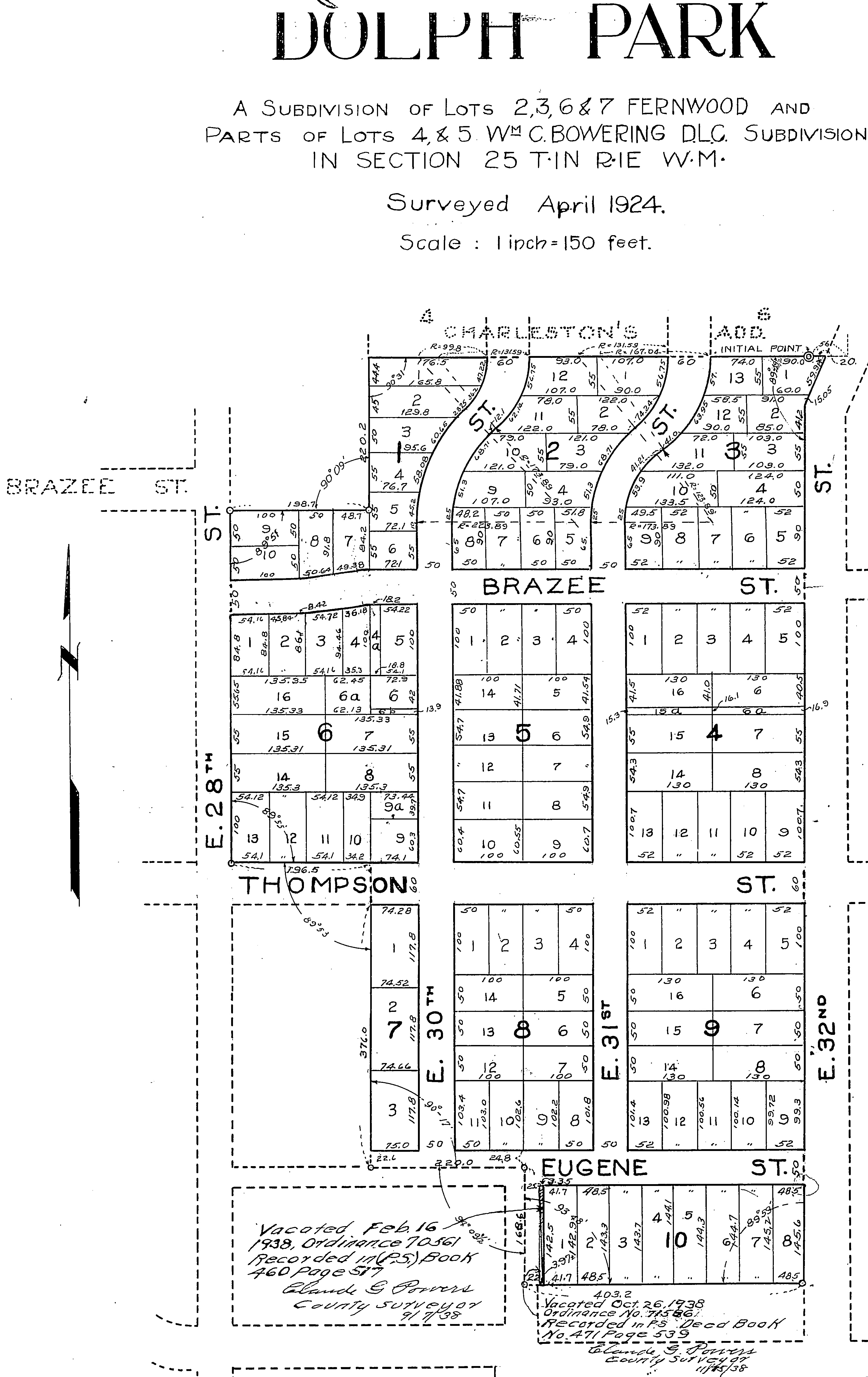
This is the Dolph Park Plat, filed with Multnomah County in April 1924. The notes at the bottom show portions of lots vacated along NE 30th between Eugene Street (today’s U.S. Grant Place) and NE Tillamook. Courtesy of Multnomah County Surveyor.
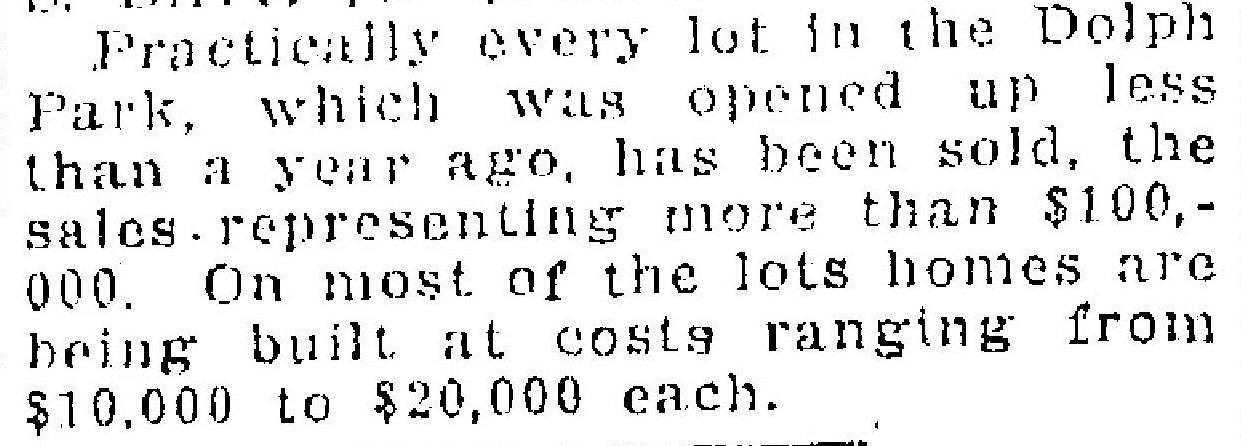
For a subdivision of its size—10 blocks and 122 lots—it arrived relatively late on the scene. It is unusual for so much open land so close in to have been unbuilt for so long. Part of that had to do with complex property ownership and legal wrangling. But when it did come to market, during the boom years of the mid 1920s, it didn’t take long to sell.
Development of Dolph Park, like other subdivisions in Portland at the time, was premised on strict racial prohibitions written right into the deeds that prohibited any other than white families living here.
Dolph Park restrictions also required minimum new construction costs which were at the high end for new construction at the time. Homes facing NE Thompson Street, which the developers clearly wanted to make the showcase street of the neighborhood, required even higher minimum construction costs.
Dolph Park was platted in April 1924 by Eliza Cardinell Dolph (1849-1934), matriarch of the Dolph family which was influential in Portland in the late 1800s and early 1900s. Eliza was the widow of Cyrus Abda Dolph (1840-1914), who had a long list of legal and civic accomplishments, including serving as Portland City Attorney, helping found Reed College, serving as lead attorney for the Northern Pacific Railroad, director of the Oregon and California Railroad, president of the Library Association of Portland and other positions. Cyrus’s brother Joseph Dolph was a two-term U.S. Senator from Oregon. Clearly, Eliza and Cyrus—and their three children—were amongst the most well off of Portlanders and the family controlled property in every quarter of the city.
Cyrus A. Dolph, about 1911 (left); Eliza Cardinell Dolph, about 1868 (right)
The property that is today’s Dolph Park, however, came to Eliza through her own side of the family: the Cardinells. Her parents Charles and Jane Cardinell arrived in Oregon in 1865 and acquired land as the city grew, amassing a small fortune. When Eliza’s father died at age 85 on August 22, 1907, real estate, investments—and several very valuable musical instruments including a Stradavarius violin—came to her and to her brother Charles B. Cardinell. Included in the estate were two tracts of property: one in the Fernwood Plat and one which was part of the Bowering Donation Land Claim, both between NE 28th and 32nd Avenue, from Thompson to Tillamook.
These properties had been owned by her parents from the moment they were platted by Hannah W. Smith in May 1887 as part of the Fernwood Addition. Real estate transfers show the property going directly from Hannah Smith to Eliza’s parents Jane and Charles Cardinell, and some properties to her younger brother Charles B. Cardinell (1858-1923) as well.
During the late 1800s and early 1900s these open lands were cultivated with berry and orchard crops. Small-scale farming and grazing occurred as other nearby neighborhoods began to grow. Today’s Northeast 33rd Avenue was a constant presence: first, a dirt-track county road that marked the edge of city limits; then increasingly a through-way for access to agriculture along the Columbia Slough; then prime access to booming brand-new nearby residential neighborhoods.
In the early 1920s, with the explosion in real estate values all around these undeveloped lands—Irvington to the west, Waynewood and Alameda to the north, Beaumont and Rose City Park to the east—Eliza Dolph recognized the attractiveness and marketability of her long-held family properties. Following the death of her brother in 1923 and the settling of his estate, she brought together the Cardinell properties with those owned by four other families to create Dolph Park. The plat was filed on June 30, 1924, containing 10 blocks and 122 lots.
The first classified advertisement for property in the “beautiful wooded tract” appeared in August 1925, noting the deed restrictions that were placed on the property by Eliza Dolph and the other owners, which would have been a selling point to the buyers they sought. There were three required conditions of ownership in Dolph Park, the first of which is shocking, but sadly common in many Portland neighborhoods at this time:
“In consideration of the mutual benefits, the dedicators do hereby declare that for a period of twenty-five years from the date of this dedication the premises shall be used exclusively for residence purposes and shall be occupied by the white race and no member of any race other than the white race shall own or occupy any portion of Dolph Park;
“No residence shall be built upon the lots facing upon Thompson Street which shall cost less than $5,000;
“No residence shall be built upon any other lot in Dolph Park costing less than $4,000.”
This form of institutional racism was formally expressed in other new Portland subdivisions of the era, and was a fundamental, pervasive, informal force throughout Portland and Oregon. Later, in the 1930s, the practice of redlining—designating areas where banks would not offer loans for purchase or maintenance—affected property values and families’ ability to accumulate wealth.
Dolph Park became an enclave of wealthy white families, many of whom at the time made their fortunes in the forest products and manufacturing sectors. City directory entries from Dolph Park in those early years read like a who’s-who of Portland money and influence.
On September 6, 1925, in its first reference to the new subdivision, The Oregonian carried a short news story about Dolph Park:
One year later, on September 19, 1926, the newspaper reported that almost every lot had been sold:
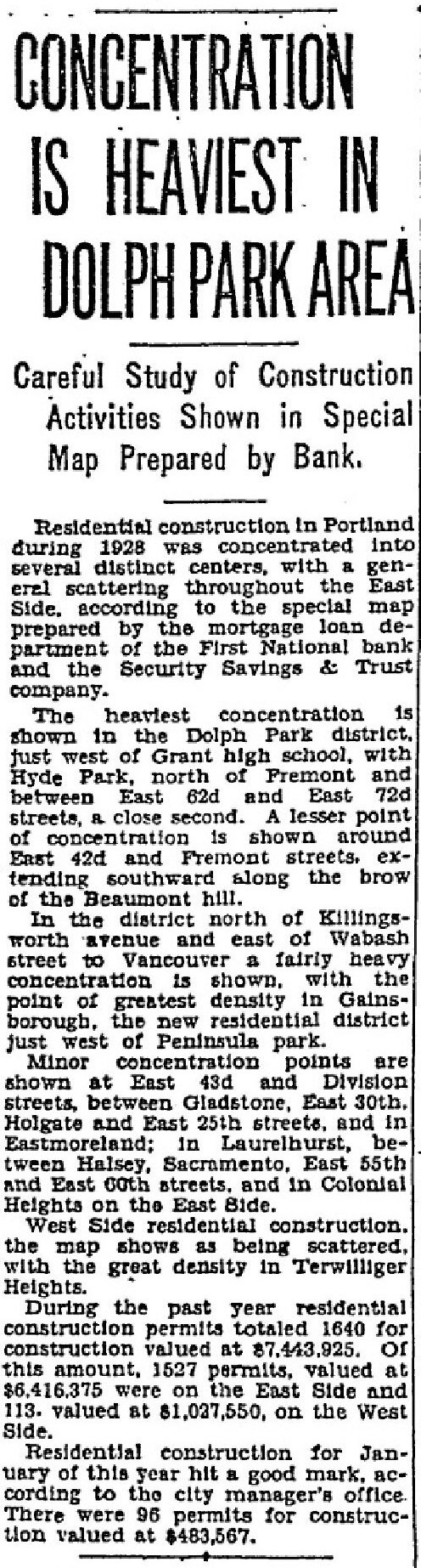
Like a pulse of work moving through the system, architects, owners and builders were busy making their plans and 1928 was a big year for construction in Dolph Park. This is from the Oregon Journal on February 3, 1929.
~ ~
Here’s an interesting way to look at it: a compilation we’ve built of four Sanborn Fire Insurance Company map plates (click below to enlarge) which provides a snapshot in time from 1924, just as the property was being formally platted. The recognizable grid of streets is present all around, but the future Dolph Park is still an unformed island in the middle of it all, showing several random houses, one large home near 33rd and Tillamook, and scattered green houses. Fernwood School is in the lower right. Eugene Street would later become part of today’s U.S. Grant Place. What other changes do you see?
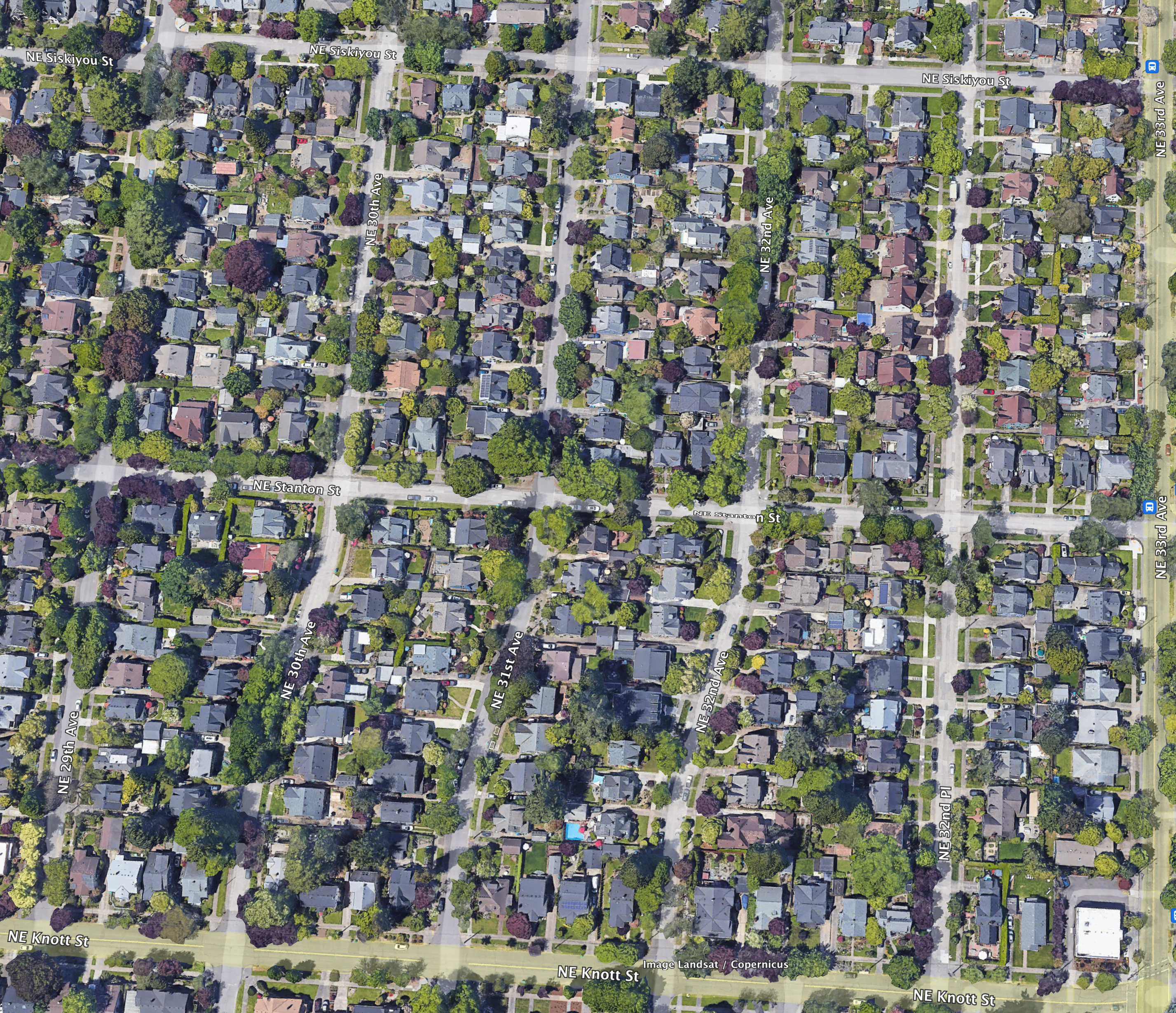
Those nice sweeping bends leading north from Knott Street between NE 29th and 31st in the Alameda neighborhood are not there by accident: they were put there on purpose to solve a very specific problem.
But there was a slow-moving accident that made them necessary and it involved bad the absence of planning, perhaps a measure of greed and too little communication, plus the passage of time. Figuring out this back story has been a bit of a puzzle, which is fine because it represented an historic puzzle on a scale never attempted back in the day, more than 100 years ago.
You know the bends we’re talking about. Take a look:
Google Earth image showing the area bounded by Siskiyou, 29th, 33rd and Knott which posed major challenges to developers in the 19-teens until the city came up with a simple idea but hard-to-achieve plan. Toward the bottom of the photo, note the curved streets leading north off Knott at NE 29th, NE 30th and NE 31st.
Understanding Plats and Subdivisions
To understand what happened here, it helps to know about plats and subdivisions, which are different than actual neighborhood names. Portland is made up of more than 900 plats. A plat is a localized engineering plan and legal survey for development of a subdivision that shows the precise location of streets and lots. Back in the day developers gave these plats names that would catch a prospective home buyer’s eye, or that meant something to the developer.
Today’s Alameda neighborhood, for instance, is made up of 23 separate plats, all filed at different times by different developers who were competing with each other and speculating on market conditions when they bought chunks of what had been old homesteads and farms claimed in the 1850s and 1860s. There was indeed an Alameda Park plat (filed in 1909 by the Alameda Land Company), but it’s only one piece of what the City of Portland today refers to as the Alameda neighborhood. 22 other subdivision plats—with names now lost to time except on property legal descriptions—make up today’s neighborhood.
Here in today’s Alameda we’re made up of the following plats: Alameda Park, Olmsted Park, Meadow Park, Linlithgow Park, Homedale, Irvington, Irvingdale, Irvingwood, Edgemont, Charleston’s Addition, Pearson’s Addition, Stanton Street Addition, Hudson’s Addition, Gile Addition, Town of Wayne, Town of Wayne Replat, Quinn’s addition to Town of Wayne, Waynewood, Dunsmeade, Hillside, George Place, Bowering Donation Land Claim Tract, Norton’s Subdivision, and Gleneyrie. Phew. All filed by different owners/developers with the county surveyor in the 40 years between 1882-1922.
Remembering the deep history of these lands
Going back in time, it’s important to remember that before these lands were claimed as homesteads by the first white Euro-American arrivals, the federal government forcibly dispossessed the area’s indigenous people from these lands. All of us in the Portland area live today on lands ceded to the U.S. by Chinookan tribes and bands; their former home lands since time immemorial. Read more about this deep history here.
This area was part of the City of East Portland until 1891
The east side wasn’t actually Portland until after 1891, it was East Portland, a separate city. Prior to that, we were three separate cities sharing some limited common infrastructure, but with different character and focus: Portland (on the west side of the river), East Portland and Albina.
In 1891—in an attempt to roll together the greater Portland area population into one number that would intimidate rival Seattle which was growing fast—the three towns consolidated into one (46,385 people in Portland + 10,000 people in East Portland + 5,000 people in Albina = 61,385 people total in the Portland “metropolitan” area). Take that, Seattle (total 1890 population: 42,837).
There had been a boomlet of development about the time the transcontinental railroad arrived in Portland in the spring of 1882, when some plats were filed in East Portland including “The Town of Wayne” plat in the heart of today’s Alameda. After the Lewis and Clark Centennial Exposition in 1905, which put Portland on the map, a bunch more plats were filed, and then again during the 1920s, after the pandemic.
But let’s get back to the bends.
Too many disconnected plats – a real estate collision
Think of this accident of time as a kind of real estate development collision. The helter-skelter nature of platting before we became part of Portland—fueled in part by spikes in the real estate market which drove owners to create small, disconnected parcels on paper that were never actually developed—resulted in plats with different types of street and lot layouts. As larger, newer and better-planned subdivisions spread out to divide up more territory, the patchwork northwest corner of 33rd and Knott became a vortex of confusion. The city coined a perfect term for it at the time: misfit platting.
Some plats had alleys, some didn’t. Some had many narrow lots. Some had fewer larger lots. There was only one through street and it had varying widths. Corners didn’t line up. There was no street naming protocol. In short, it was a mess.
But the area was still just multiple hopeful plans on paper—these were open fields well into the late 19-teens, even though more than 45 owners had already bought in—and people continued buying, holding and even trading lots as a speculative investment. Here’s what it looked like by about 1915:
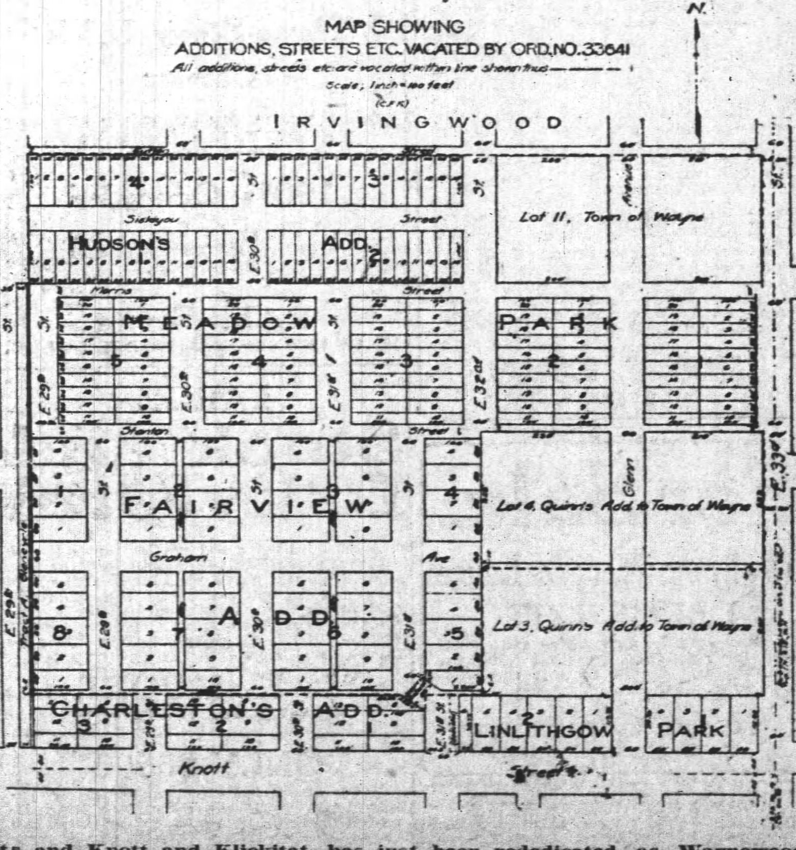
This diagram from the Oregon Journal on May 20, 1918 shows the jumble of plats that used to occupy thearea bounded today by NE Siskiyou on the north, Knott on the south, 33rd on the east and 29th on the west. The plats include: Town of Wayne, (1882); Quinn’s Addition to the Town of Wayne, (1886); Hudson’s Addition, (1892); Fairview Addition, (1889); Meadow Park (1890); and Charleston’s Addition, (1895). A careful examination shows that each plat is organized differently.Note that the Fairview Addition even had alleys.
In the early 1910s, with construction and sales well underway in nearby Irvington, Alameda, Beaumont and Rose City Park, developers turned to the next nearby open lands in the pipeline for development and found this total mess.
There was only one real solution that came to mind: Go back to the drawing board and replat the whole area, something never done on this scale (and perhaps never since). But how you do that with specific lots already owned by dozens of hopeful investors in planned subdivisions that had been legally filed and on the books for as long as 30 years?
You see the problem now.
It first surfaced in the newspaper in February 1915:
From The Oregonian, February 12, 1915
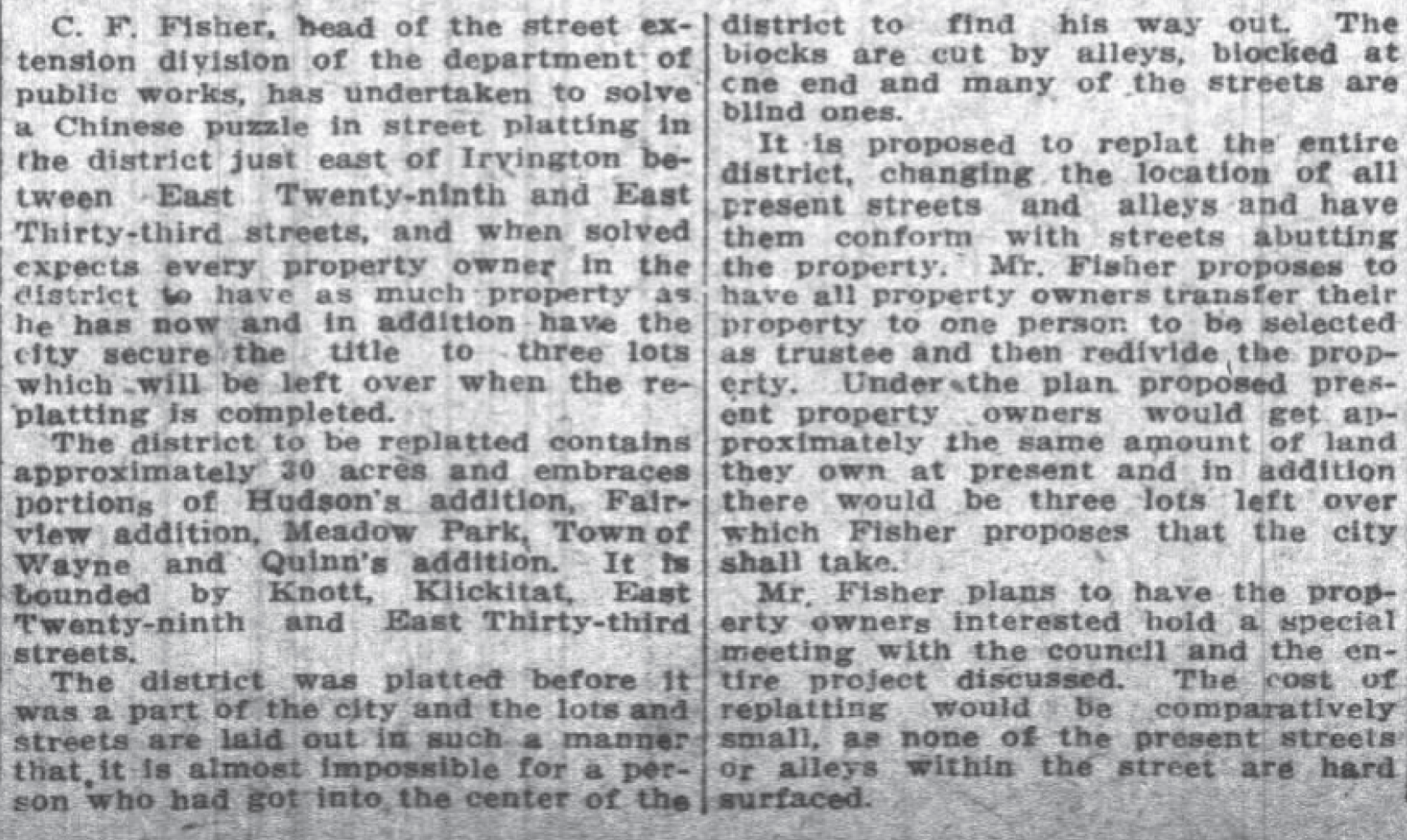
The problem percolated among the property owners and the city engineering office for a while until they developed an ambitious plan about how to proceed:
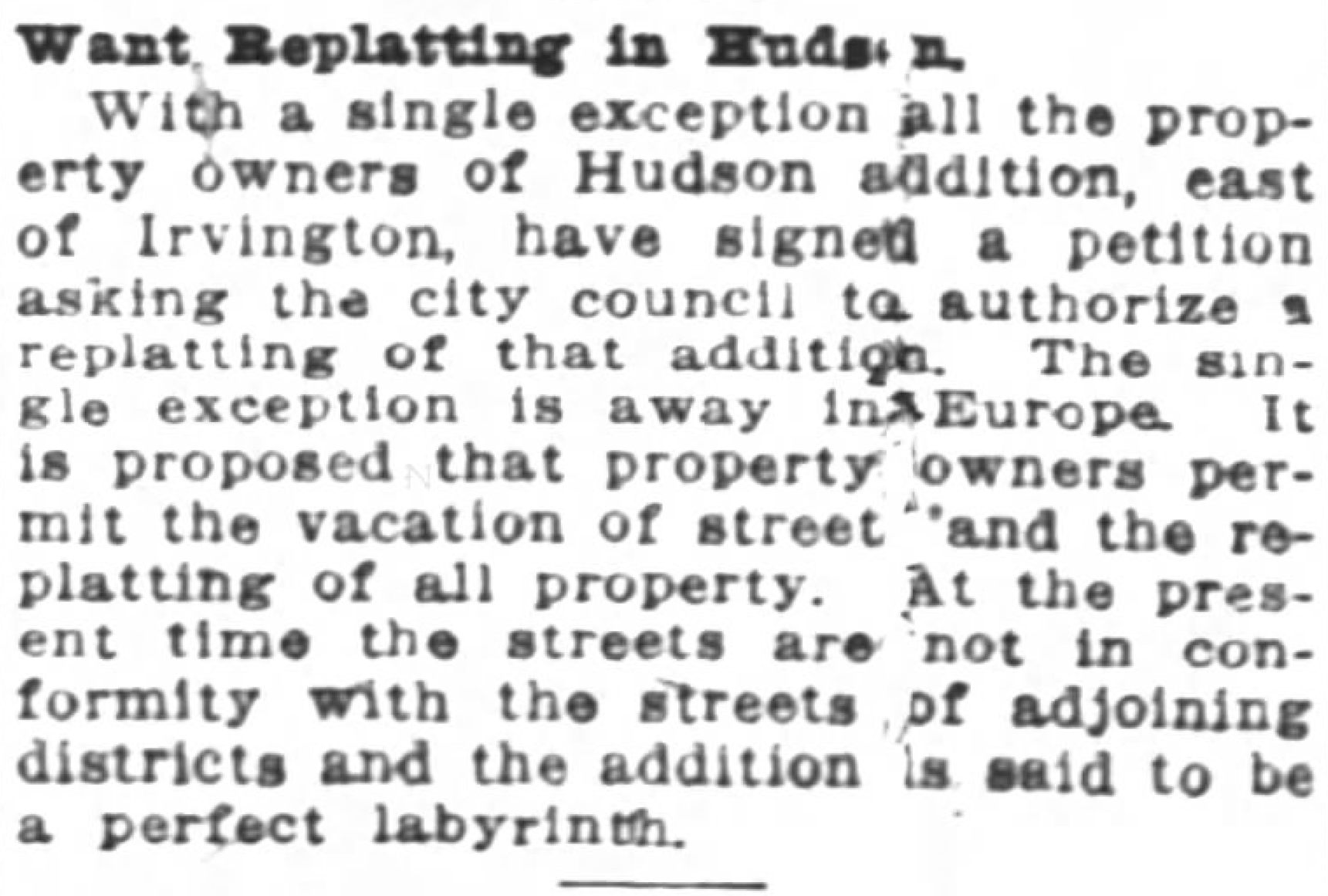
From the Oregon Journal, June 20, 1915
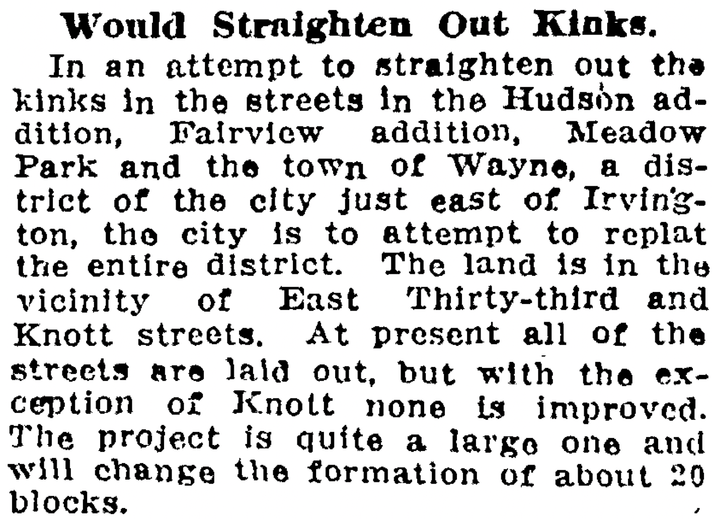
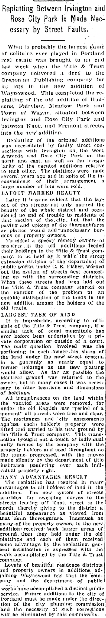
Fisher’s meeting with the property owners went well and all but one got on board. A petition was signed a few months later to send a message of good faith to the city. The last line of the article summed up the problem nicely: the addition is said to be a perfect labyrinth.
From the Oregon Journal, January 9, 1916
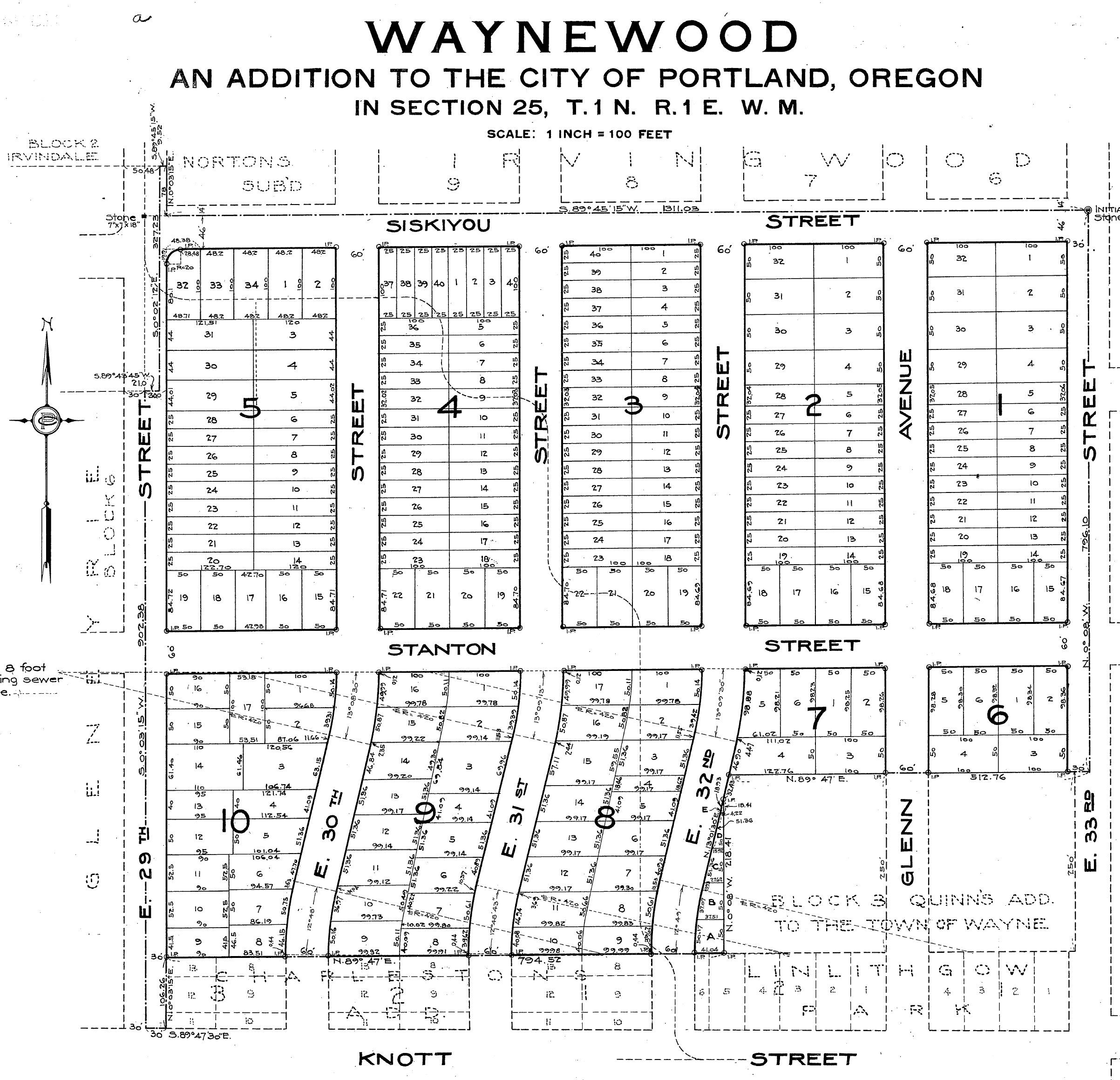
The city engineers worked with the Title and Trust Company to do the necessary temporary title transfers to a holding trust that would allow a clean slate and then started drawing different lines, keeping everyone whole, eliminating the labyrinth, adding those curves, and retitling every single lot back out of the temporary trust. The result was a brand-new subdivision called Waynewood, a tip of the hat we suppose to the old Town of Wayne plat and the Irvingwood subdivision just to the north.
The official plat of Waynewood filed with the Multnomah County Surveyor on February 2, 1918 containing the brand-new retitled lots and redrawn streets. In addition to understanding how the curves came to be, the replatting process also explains the misaligned corner at NE 29th and Siskiyou.
A story in the Oregon Journal on May 30, 1920 explained the process and the benefits:
Today all of the energy and consternation that went into that process is completely invisible to us here in their imagined future (at least until now), our only clues the graceful curved streets that lead north from Knott Street. Those curves are reflected south of Knott as well, but they came later when the subdivision known as Dolph Park was platted in 1924, and that’s another story.
While walking in the neighborhood—the best way to observe history in action—we’ve wondered about the very long block between Ainsworth and Simpson, bounded by NE 33rd and NE 37th. Maybe you’ve wondered too: the north-south streets of 34th, 35th and 36th don’t go through, leaving unusually deep and narrow lots. These kinds of things—like the strange zig-zag on Prescott we call the Prescott Street Jog—make us ask: What’s the story behind that?
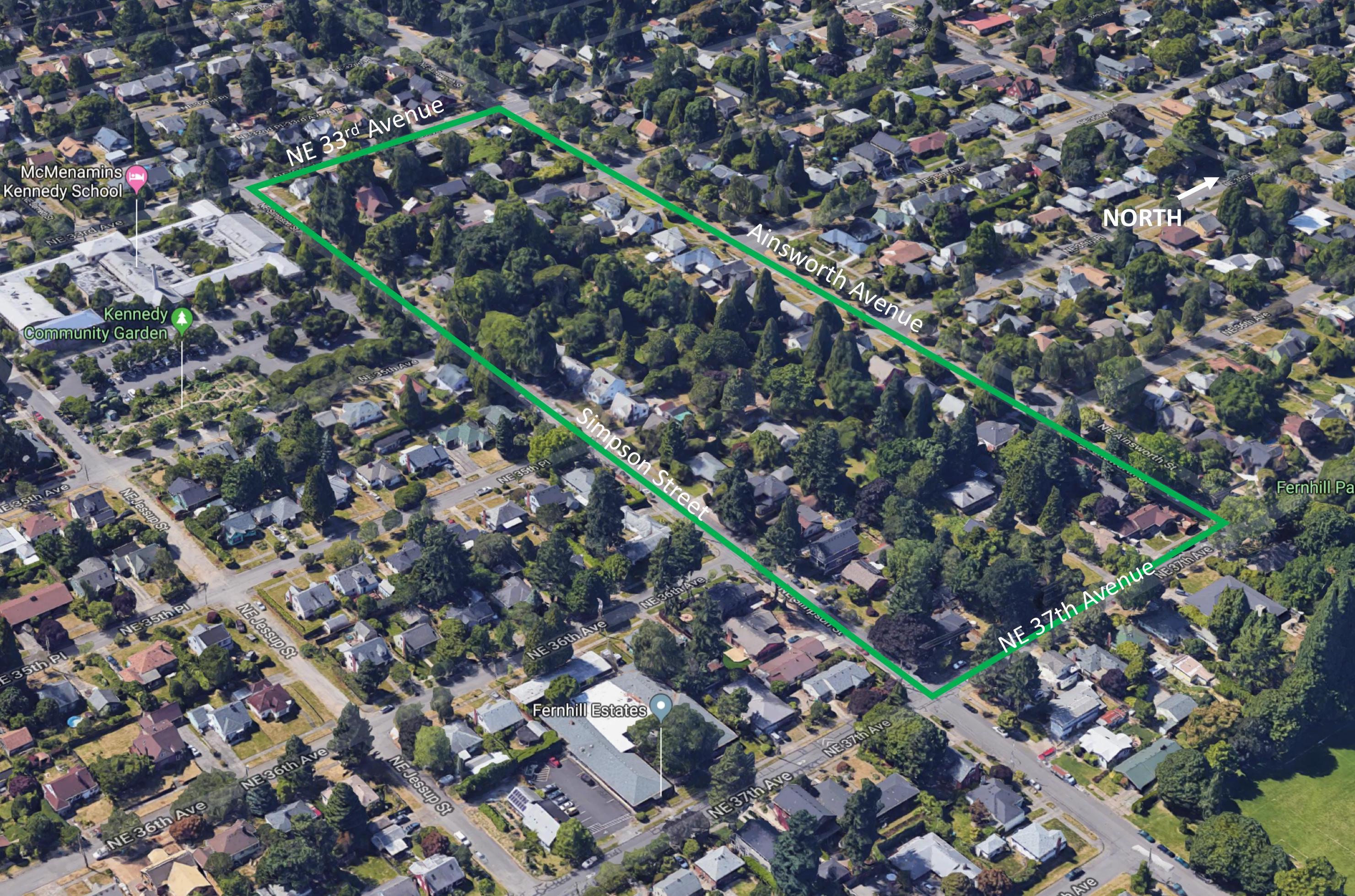
Here, take a look. It’s the block just west of Fernhill Park:
That’s one long block. A Google image looking northwest at the long block (outlined in green). Note that none of the numbered cross streets, from 33rd to 37th, cross this long block. How come?
The long, narrow configuration of this block stems from decisions made more than 100 years ago by John D. Kennedy, the man who once owned much of the property between Killingsworth, Ainsworth, NE 33rd and NE 42nd, and for whom Kennedy School was named.
Born in County Limerick, Ireland in 1852, Kennedy immigrated to Oregon in 1866, finding his way to Baker City where he worked in and then owned a dry goods store. After coming to Portland about 1881, Kennedy bought this property—then outside the city limits and far from anything that even looked like development—which was originally part of the 1855 Isaac Rennison Donation Land Claim.
John D. Kennedy, about 1920. Photo originally from the Ryerson Collection, borrowed here from McMenamin’s Kennedy School.
Kennedy was an early-in speculator, perhaps 15 years ahead of his time and the market. Northeast Portland’s ripeness for real estate didn’t really take place until the years after the 1905 Lewis and Clark Exposition when it seemed anyone who could was buying property or building houses.
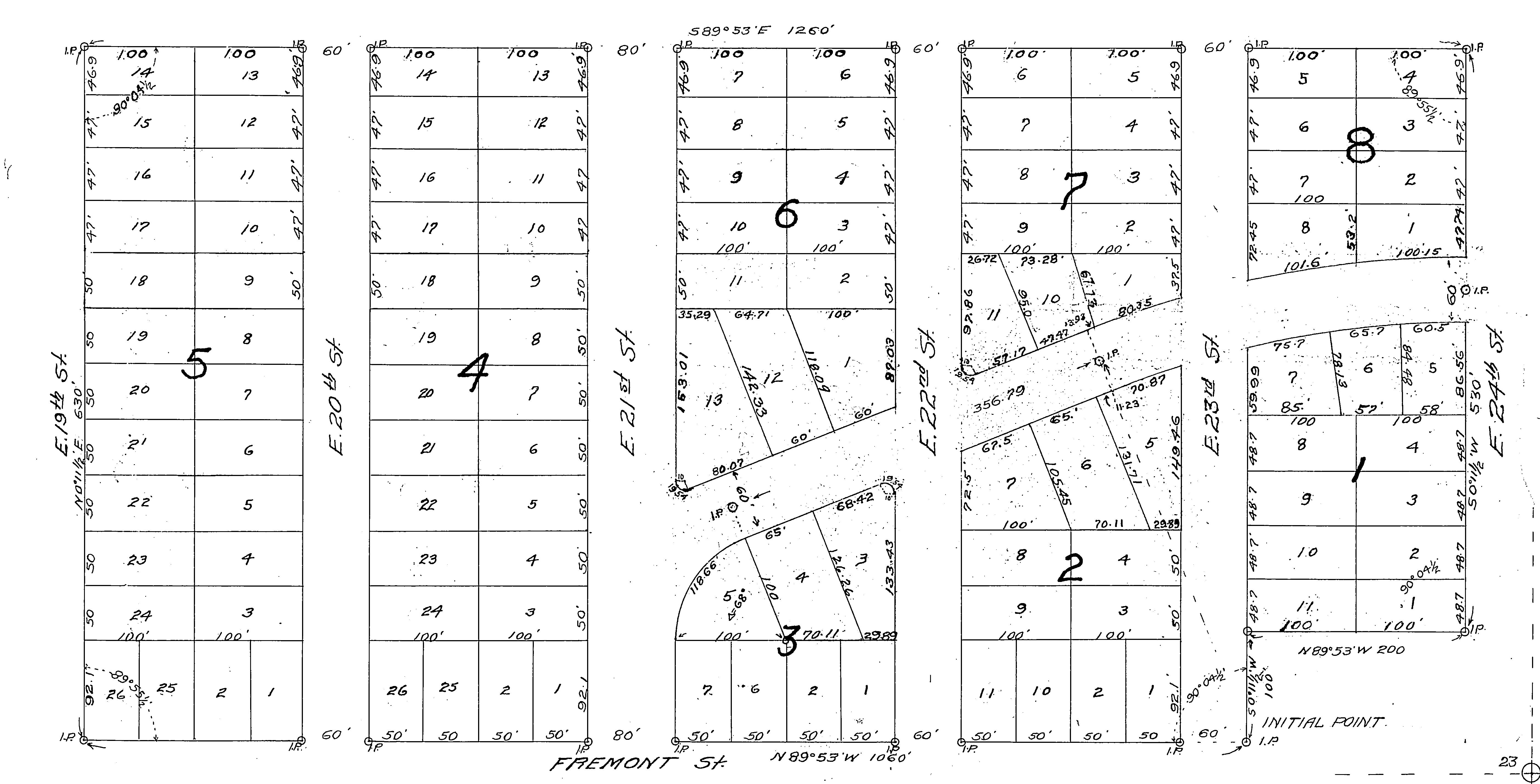
But Kennedy had platted these lands as the Kennedy Addition back in 1890, a grid of 15 square blocks with more than 200 lots. Here’s his original plat:
Kennedy Addition plat filed with the Multnomah County Surveyor’s Office, 1890. The grid survived, even if the street names didn’t. Translation: County Road = NE 33rd; Cleveland Street = NE 34th; Harrison Street = NE 35th; Morton Street (which was built as Marguerite Avenue)= NE 35th Place; Thurman Street = NE 36th; Blaine Street = NE 37th Avenue; Cypress Avenue = Jessup Street; Myrtle Avenue = Simpson Street. Barkholtz was an inholding property owner who wasn’t Kennedy but who went along with the plat. Interesting to note that in later years, that is the one area of the long block where a cul de sac was built.
Two years later in 1892, he platted Kennedy’s Second Addition, adjacent to the east, with more street names that didn’t make it to today (Morrow, Gilliam, Hughes and Francis). His Second Addition contained plans for another 120 homes. Speculators filed several other nearby plats about that time, including Foxchase, Irvington Park, the Willamette Addition and Railroad Heights, but they were also just lines on paper. There was no market yet for residential development.
In 1906, Kennedy filed a petition with the city to “vacate” five of the blocks in his addition. The process of vacation officially eliminates platted streets (even if they don’t yet exist), and the 1906 action—approved by City Council in ordinances 15761 and 15762—essentially erased all of the north-south streets (then called Cleveland, Harrison, Morton, Thurman and Blaine, see above) in the block between Ainsworth and Simpson, from 33rd east to 37th.
From The Oregonian, May 10, 1906
Kennedy’s stated rationale was to sell the larger chunk of land as acreage for farm fields, which is what surrounded his property at the time. It seems he was eager to sell the property and was essentially repackaging it for what was at that moment the most active part of the market (even though Northeast Portland was on the cusp of a homebuilding explosion). Not long after the City Council action, Kennedy did just that:
Classified advertisement for the vacated property, from The Oregonian, October 21, 1906
In the years that followed as urbanization spread, neighborhoods were built to the north, south and west, and Kennedy’s smart and early real estate speculation paid off. But the 12-acre parcel, with no north-south through streets due to his 1906 decision to vacate streets from the property, stayed as one big block in farm use.
After Portland voters passed a $500,000 park acquisition bond measure in 1919, Kennedy courted the city with the long block tract—a perfect park size at 12 acres—suggesting it would make a great place for playgrounds, picnic tables and ball diamonds. This was long before Fernhill Park or Wilshire Park (which have their own interesting stories well worth reading), and concurrent with consideration of Alberta Park, which was ultimately selected over Kennedy’s tract for purchase and development. Think about that: what if today’s Alberta Park had become neighborhood streets as planned, and Kennedy’s long block was a park? Hmm.
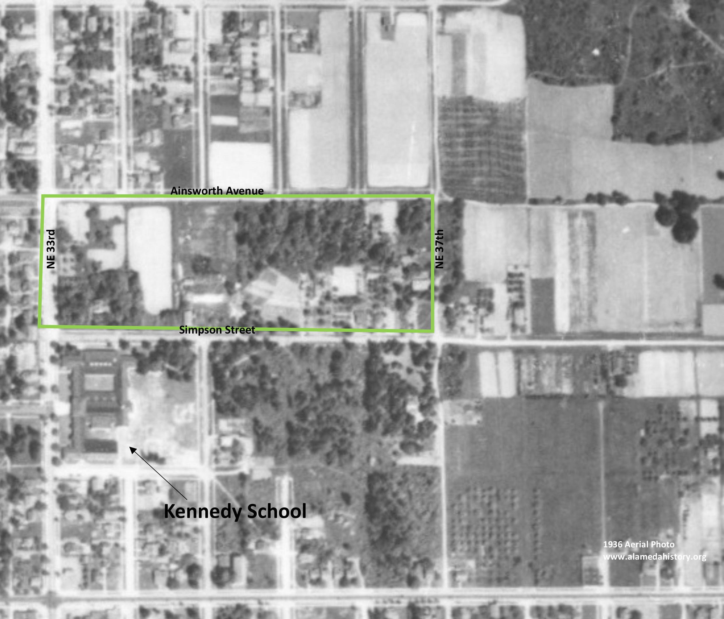
Here’s an aerial photo of the area from 1936 that shows the long block with a few homes, the oldest dating back to 1909…purchased from Kennedy after the 1906 ordinance passed creating the 12-acre parcel. One home, on the Simpson Street side, actually pre-dates Kennedy’s 1890 plat.
Detail of 1936 aerial photo. Courtesy of University of Oregon Map & Aerial Photography Library.
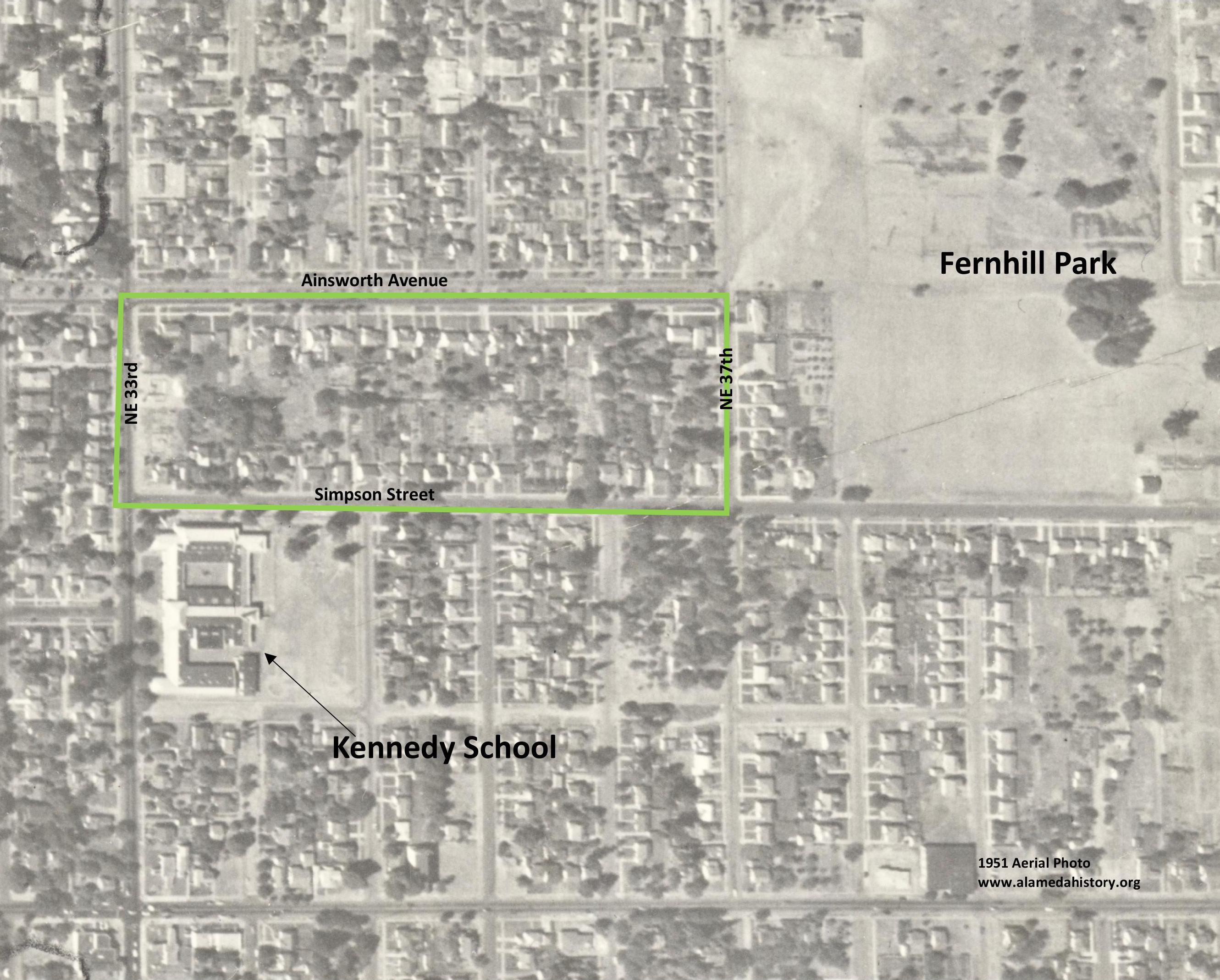
Kennedy died in December 1936. In 1938, the property was controlled by Ward D. Cook, a Portland insurance and real estate agent, who designated 80 lots on the long block ready for construction. It wasn’t until after World War II when the market truly picked up, and most of the houses were built and sold between 1940 and 1950. Here’s a glimpse from 1951 that shows the property fully built out:
Detail of 1951 aerial photo. Courtesy of City of Portland Archives.
So there you have it: In the original Kennedy’s Addition plat, that one long block was going to be five blocks. But then Kennedy did away with the blocks to better sell the property. The market came and went and came back again. Then another speculator saw opportunity and turned the island of farm into the more than 50 lots there today, most of them a very long and narrow quarter-acre each.
Homedale is the name of the property plat—once part of an orchard and dairy—that occupies the landscape bounded roughly by Fremont and Ridgewood, between NE 19th and NE 24th. Today, it’s considered part of the Alameda neighborhood. Here’s a look at the geography.
Detail from the Homedale Plat, filed in 1921. Click to enlarge.
Think of a plat as a road map filed by developers for organizing property into individual lots and streets (read more about the relationship between plats and neighborhoods here). We all live somewhere in a plat and each has its own unique story, players and moment in history. We’ve created a category here on the blog (The Plats) to hold our ongoing exploration of these stories.
While today it’s an orderly grid of streets and homes dating from 1922, less than 100 years ago the sloping landscape just below Alameda ridge that you see here was an important part of Portland’s eastside agriculture. We’ve come across several interesting descriptions that will feed your curiosity and the way you think about this landscape. Read on, from local resident Rod Paulson written in January 1976:
“Before 1921 and 1922 when city lots were staked out, much of this was an apple orchard, the remnants of which can still be seen in some back yards. The trees grew right down to the edge of the Fremont Street [side]walk and there were several old buildings on the place, residential and otherwise, including a large farmhouse painted light brown which was located close to Fremont in the vicinity of 21st Avenue. This house dated back to the 1890s or before and people lived there in apparent comfort in a rural setting, yet in the midst of modern houses that [were being built] in all directions.”
“There was another farmhouse set back a considerable distance from the street more or less in the eastern part of the orchard, and a barn was situated opposite the end of 23rd Avenue.”
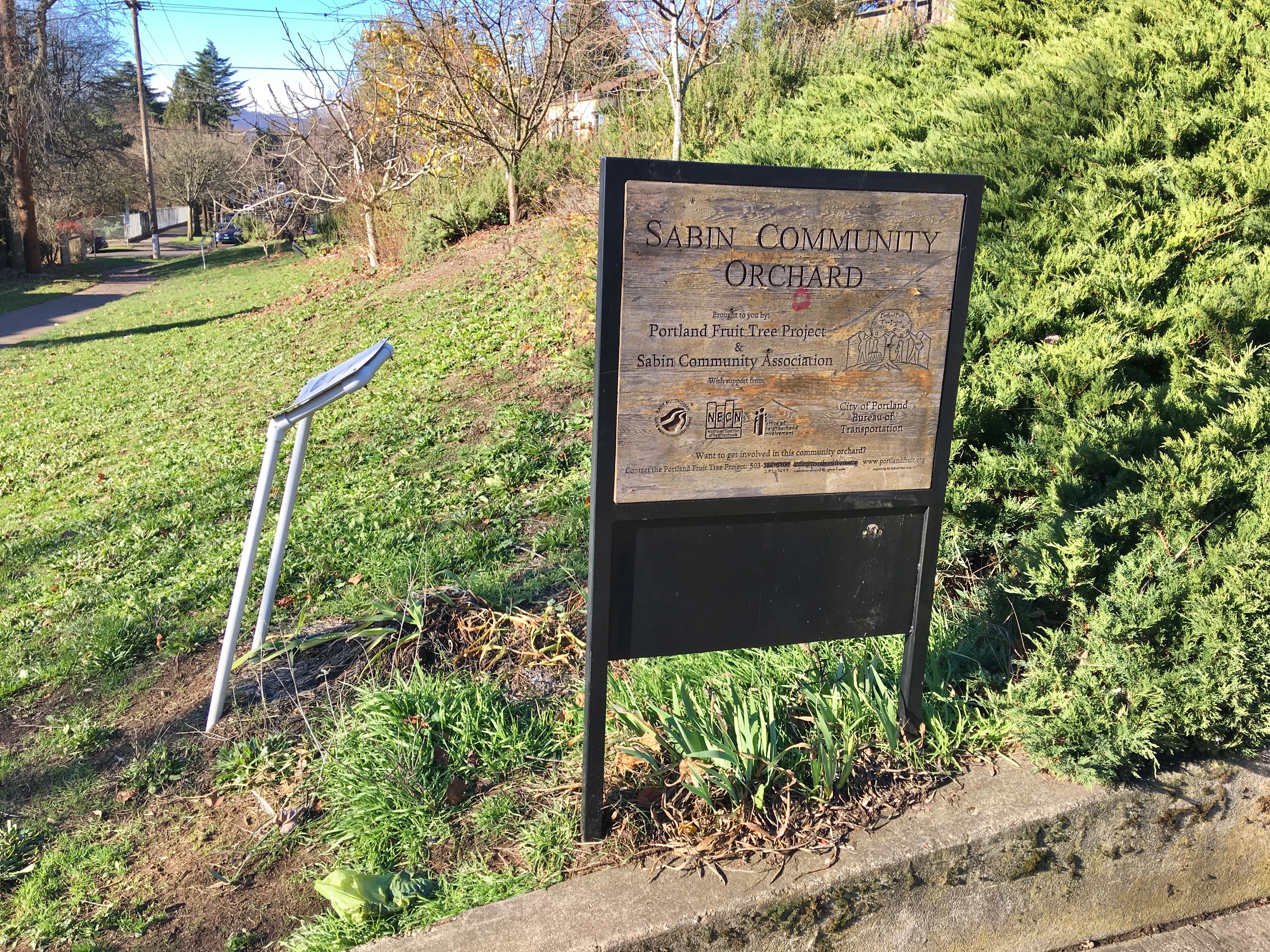
We’ve wondered about this: are isolated apple trees from the early orchard days still out there scattered across this part of the neighborhood? Can any readers confirm? In a happy coincidence, the Sabin Community Association has planted a small orchard of young trees near NE 19th and Mason, on ground that probably once was part of the old orchard:
The once and future orchard, near NE 19th and Mason, December 2018.
Owners Michael G. Munley and James T. Barron bought the future Homedale property in 1905 for $6,500 and kept it in agricultural use with an eye to eventual development, but market conditions didn’t make that worthwhile until the 1920s. Not coincidentally, Munley was son-in-law of E.Z. Ferguson, president of the Alameda Land Company which owned land just up the hill. Barron was a Ferguson business partner.
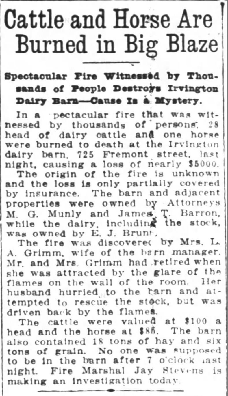
The Irvington Dairy operated from a barn situated at the northeast corner of NE 21st and Fremont from the 1890s until 1916 when a catastrophic fire destroyed much of the herd and the barn.
From the Oregon Journal, January 11, 1916. The address given–725 Fremont–is from Portland’s old addressing system and translates into the NE corner of 21st and Fremont. We did not find a follow-up news story about the fire investigation. The house remembered by Rod Paulson was home to dairy manager Grimm and his family.
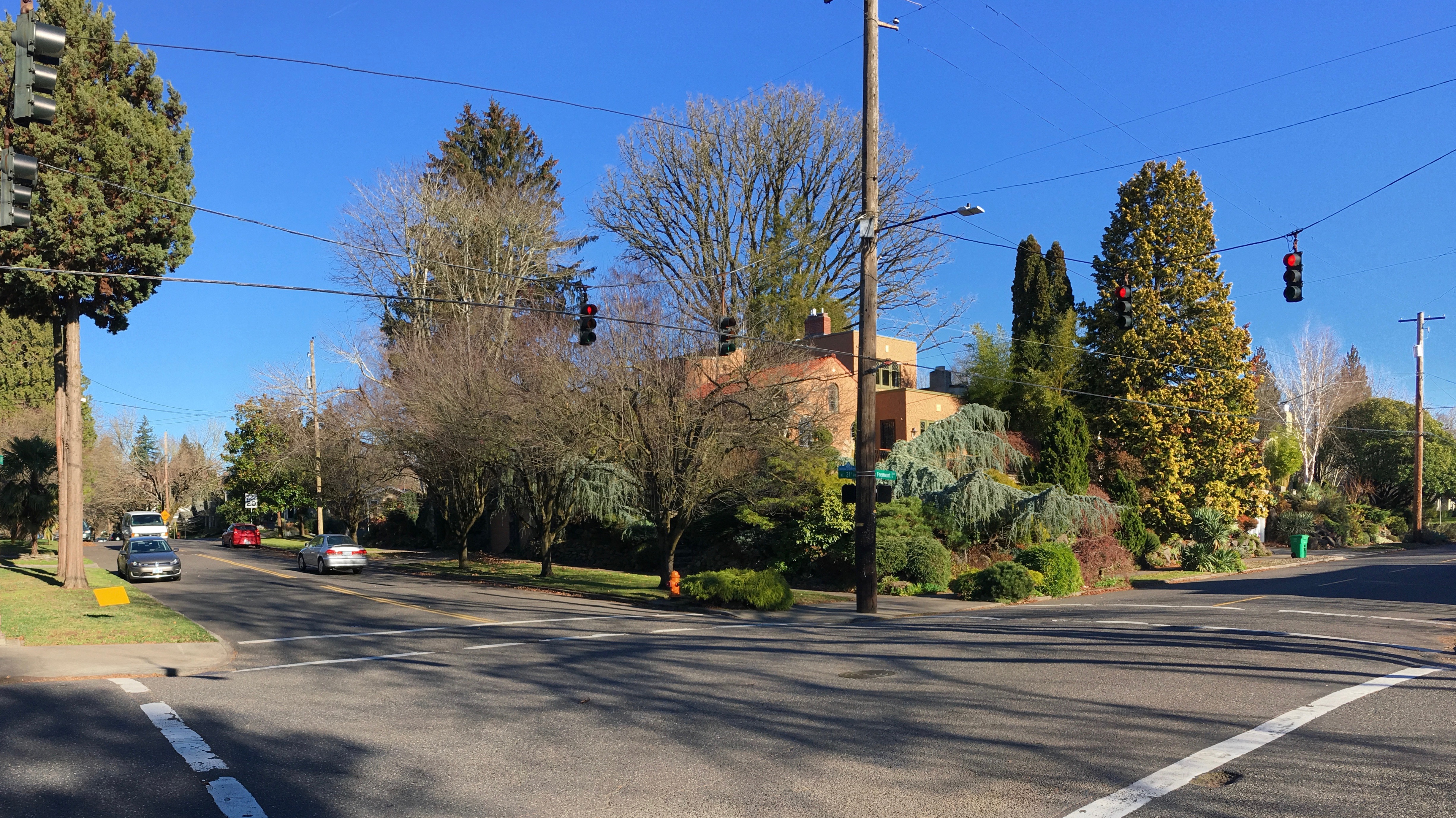
Location of the former Irvington Dairy barn at NE 21st and Fremont, looking northeast, December 2018.
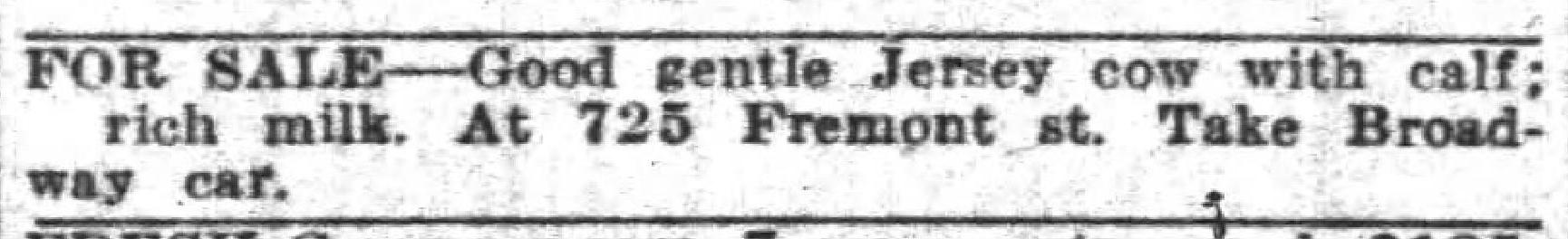
Between the terrible fire and an early 1920s resurgence in Portland’s real estate values, the time was nearing when Munley and Barron would execute the land use change and end the property’s agricultural past. In 1919, the Grimms and dairyman E.J. Bruns were selling off the last of the Munley herd:
From The Oregonian, March 30, 1919
A nearby dairy existed just to the east as well: the Pearson Place, the cow pasture where Alameda School was eventually built. The Pearson family operated their dairy there during this same time period and it too was subdivided into residential lots about the same time. You can read more about the Pearson Dairy and its time-traveling tree here (and we recommend putting on your walking shoes and your imagination to walk the perimeter of the farm).
Six years after the big fire at NE 21st and Fremont, Munley and Barron were underway with their plan to develop the property:
From The Oregonian, March 12, 1922
By the fall of 1922, the streets of Homedale had been carved into the south-facing slopes and the first homes had been built. Real estate ads even mentioned without explaining why that most lots had a fruit tree (but no mention of cows).
Interesting to note that prior to 1922, Regents Drive did not go all the way through to NE 21st because the orchard and open fields were in the way. Regents came down the hill and tee’d into NE 24th before heading south. Think of that next time you drive down Regents headed for NE 21st: the former orchard and pasture land you’re driving through.
If you’ve read this far, you deserve the reward of one of our all-time favorite news stories from that time illustrating the consequence of this early day change of land use from agriculture to residential (a subject that bears exploration in future posts). Dixon Place is the next subdivision to the west just a few blocks over, between Fremont to Shaver and from NE 15th to NE 19th, part of today’s Sabin neighborhood. What a great headline:
From The Oregonian, May 3, 1923
Dairies like the one at NE 21st and Fremont–and many more small dairies around town–occupied a unique niche in time as Portland grew between 1890 and the 19-teens. As population and growth exploded and property became more valuable for housing, the departure of the dairies was a bellwether of change. More from the front lines of subdivision-dairy conflict here. It’s a fascinating story.


