While walking in the neighborhood—the best way to observe history in action—we’ve wondered about the very long block between Ainsworth and Simpson, bounded by NE 33rd and NE 37th. Maybe you’ve wondered too: the north-south streets of 34th, 35th and 36th don’t go through, leaving unusually deep and narrow lots. These kinds of things—like the strange zig-zag on Prescott we call the Prescott Street Jog—make us ask: What’s the story behind that?
Here, take a look. It’s the block just west of Fernhill Park:
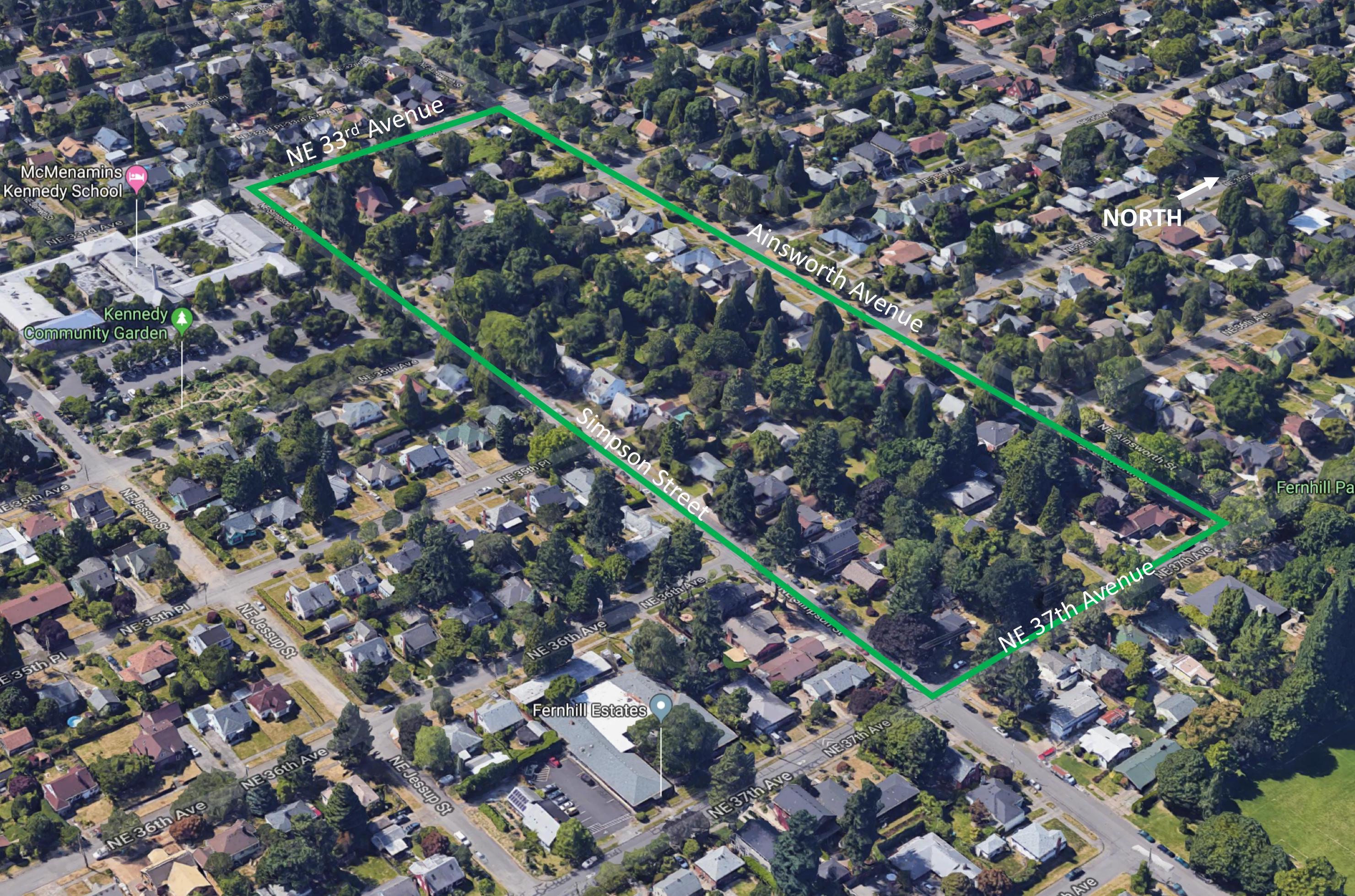
That’s one long block. A Google image looking northwest at the long block (outlined in green). Note that none of the numbered cross streets, from 33rd to 37th, cross this long block. How come?
The long, narrow configuration of this block stems from decisions made more than 100 years ago by John D. Kennedy, the man who once owned much of the property between Killingsworth, Ainsworth, NE 33rd and NE 42nd, and for whom Kennedy School was named.
We met John D. Kennedy in our recent post about his 1929 zone change petition to turn nearby residential land at 33rd and Killingsworth into commercial property.
Born in County Limerick, Ireland in 1852, Kennedy immigrated to Oregon in 1866, finding his way to Baker City where he worked in and then owned a dry goods store. After coming to Portland about 1881, Kennedy bought this property—then outside the city limits and far from anything that even looked like development—which was originally part of the 1855 Isaac Rennison Donation Land Claim.

John D. Kennedy, about 1920. Photo originally from the Ryerson Collection, borrowed here from McMenamin’s Kennedy School.
Kennedy was an early-in speculator, perhaps 15 years ahead of his time and the market. Northeast Portland’s ripeness for real estate didn’t really take place until the years after the 1905 Lewis and Clark Exposition when it seemed anyone who could was buying property or building houses.
But Kennedy had platted these lands as the Kennedy Addition back in 1890, a grid of 15 square blocks with more than 200 lots. Here’s his original plat:

Kennedy Addition plat filed with the Multnomah County Surveyor’s Office, 1890. The grid survived, even if the street names didn’t. Translation: County Road = NE 33rd; Cleveland Street = NE 34th; Harrison Street = NE 35th; Morton Street (which was built as Marguerite Avenue)= NE 35th Place; Thurman Street = NE 36th; Blaine Street = NE 37th Avenue; Cypress Avenue = Jessup Street; Myrtle Avenue = Simpson Street. Barkholtz was an inholding property owner who wasn’t Kennedy but who went along with the plat. Interesting to note that in later years, that is the one area of the long block where a cul de sac was built.
Two years later in 1892, he platted Kennedy’s Second Addition, adjacent to the east, with more street names that didn’t make it to today (Morrow, Gilliam, Hughes and Francis). His Second Addition contained plans for another 120 homes. Speculators filed several other nearby plats about that time, including Foxchase, Irvington Park, the Willamette Addition and Railroad Heights, but they were also just lines on paper. There was no market yet for residential development.
In 1906, Kennedy filed a petition with the city to “vacate” five of the blocks in his addition. The process of vacation officially eliminates platted streets (even if they don’t yet exist), and the 1906 action—approved by City Council in ordinances 15761 and 15762—essentially erased all of the north-south streets (then called Cleveland, Harrison, Morton, Thurman and Blaine, see above) in the block between Ainsworth and Simpson, from 33rd east to 37th.

From The Oregonian, May 10, 1906
Kennedy’s stated rationale was to sell the larger chunk of land as acreage for farm fields, which is what surrounded his property at the time. It seems he was eager to sell the property and was essentially repackaging it for what was at that moment the most active part of the market (even though Northeast Portland was on the cusp of a homebuilding explosion). Not long after the City Council action, Kennedy did just that:
Classified advertisement for the vacated property, from The Oregonian, October 21, 1906
In the years that followed as urbanization spread, neighborhoods were built to the north, south and west, and Kennedy’s smart and early real estate speculation paid off. But the 12-acre parcel, with no north-south through streets due to his 1906 decision to vacate streets from the property, stayed as one big block in farm use.
After Portland voters passed a $500,000 park acquisition bond measure in 1919, Kennedy courted the city with the long block tract—a perfect park size at 12 acres—suggesting it would make a great place for playgrounds, picnic tables and ball diamonds. This was long before Fernhill Park or Wilshire Park (which have their own interesting stories well worth reading), and concurrent with consideration of Alberta Park, which was ultimately selected over Kennedy’s tract for purchase and development. Think about that: what if today’s Alberta Park had become neighborhood streets as planned, and Kennedy’s long block was a park? Hmm.
Here’s an aerial photo of the area from 1936 that shows the long block with a few homes, the oldest dating back to 1909…purchased from Kennedy after the 1906 ordinance passed creating the 12-acre parcel. One home, on the Simpson Street side, actually pre-dates Kennedy’s 1890 plat.
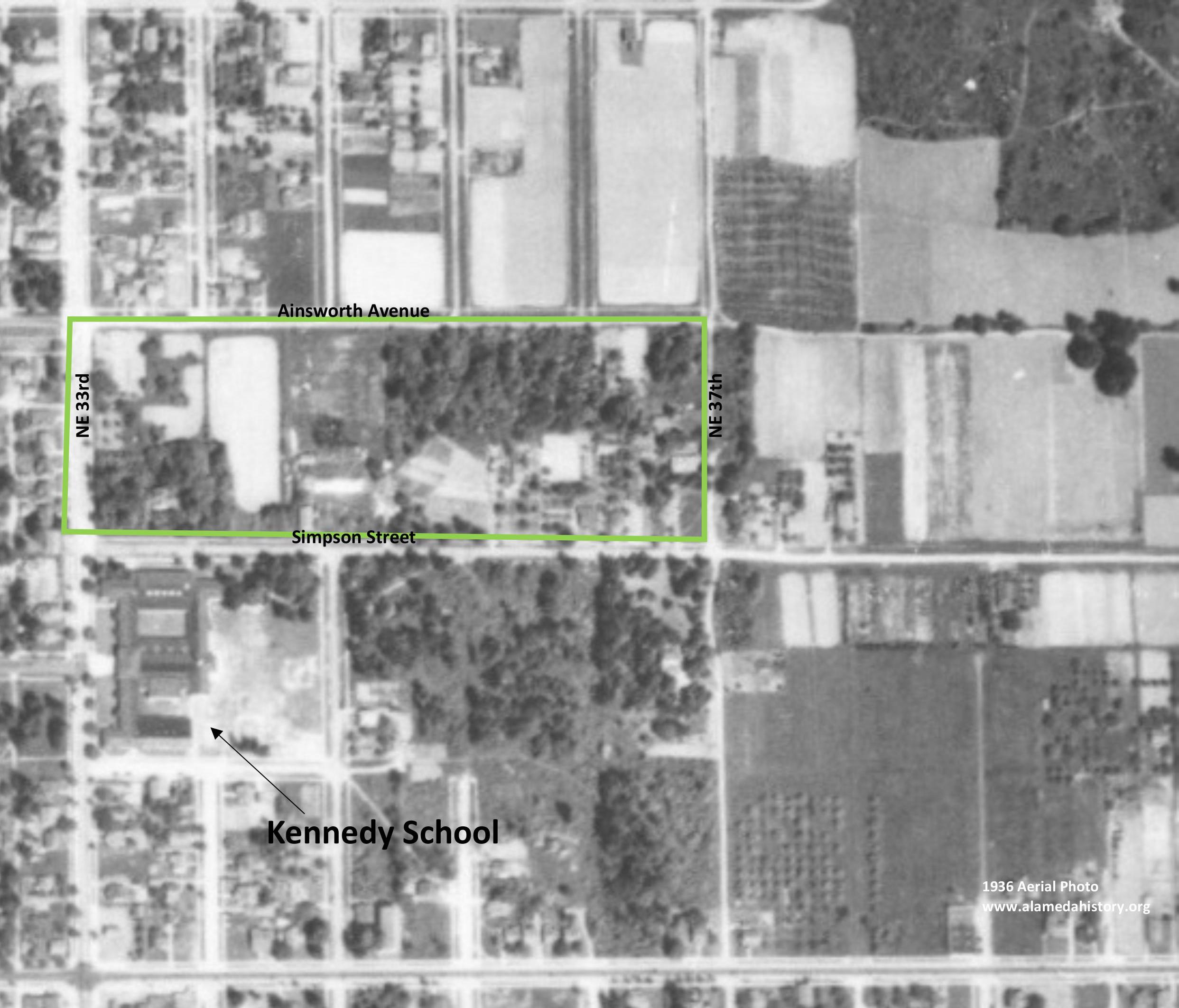
Detail of 1936 aerial photo. Courtesy of University of Oregon Map & Aerial Photography Library.
Kennedy died in December 1936. In 1938, the property was controlled by Ward D. Cook, a Portland insurance and real estate agent, who designated 80 lots on the long block ready for construction. It wasn’t until after World War II when the market truly picked up, and most of the houses were built and sold between 1940 and 1950. Here’s a glimpse from 1951 that shows the property fully built out:
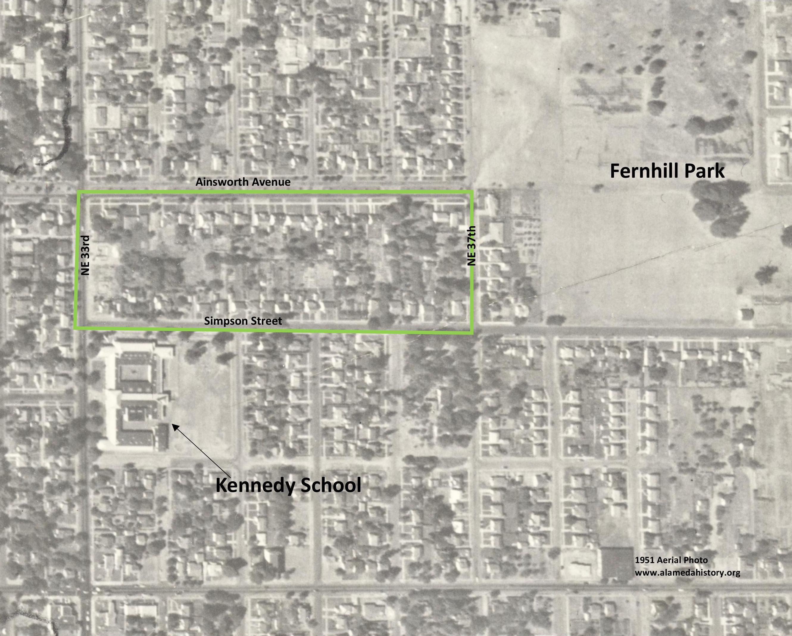
Detail of 1951 aerial photo. Courtesy of City of Portland Archives.
So there you have it: In the original Kennedy’s Addition plat, that one long block was going to be five blocks. But then Kennedy did away with the blocks to better sell the property. The market came and went and came back again. Then another speculator saw opportunity and turned the island of farm into the more than 50 lots there today, most of them a very long and narrow quarter-acre each.

