Fixing the Perfect Labyrinth

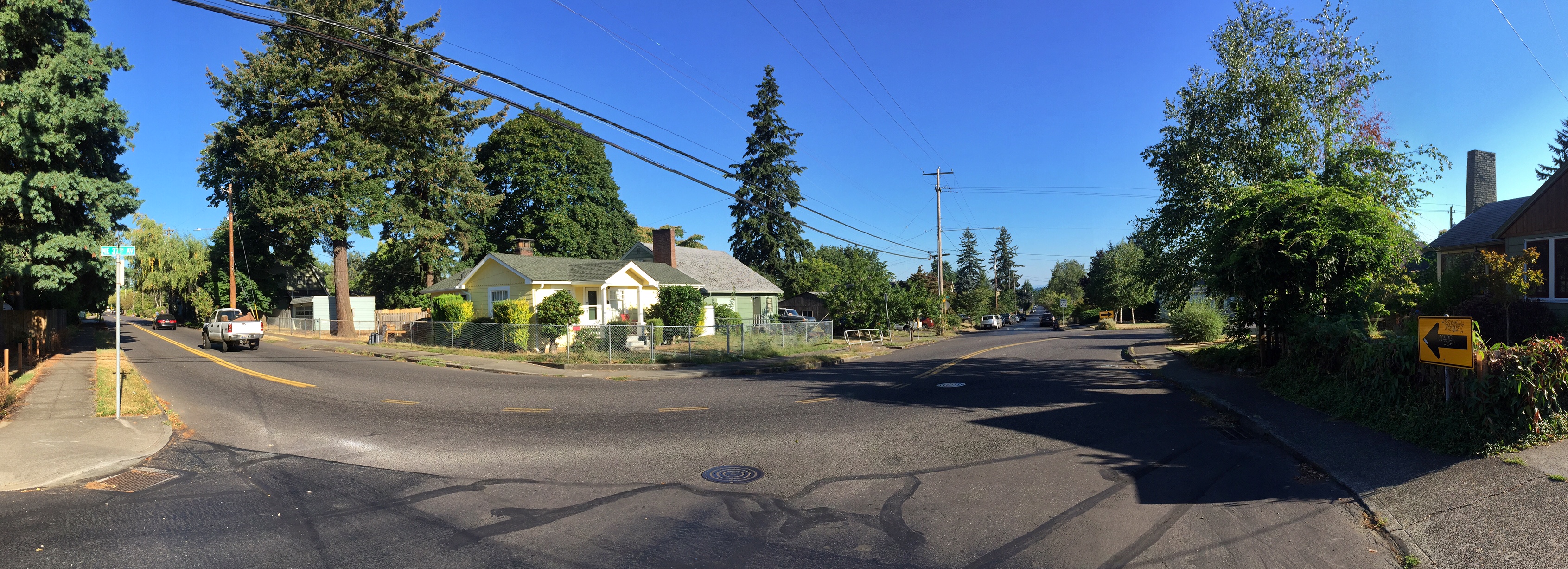
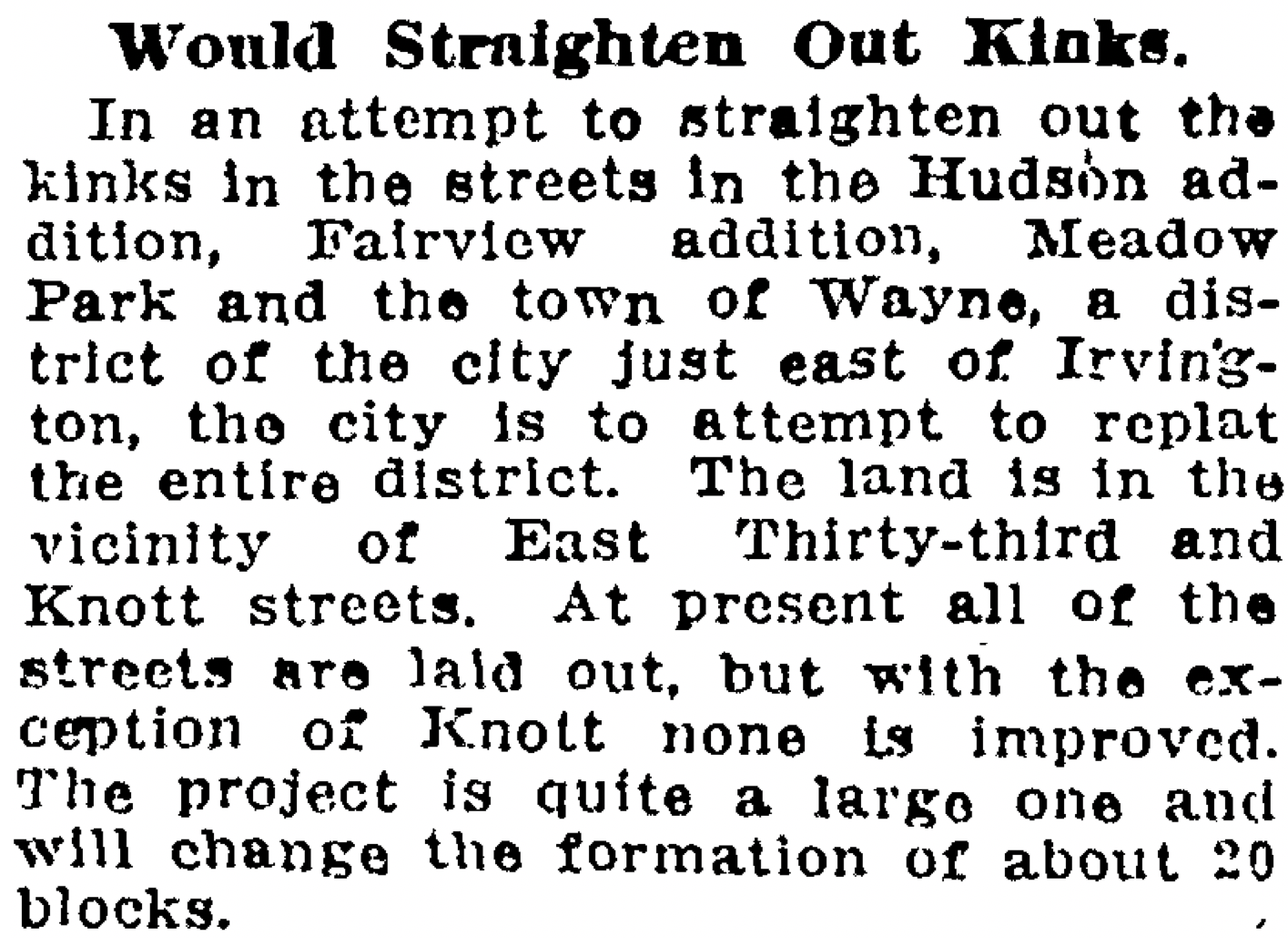
Those nice sweeping bends leading north from Knott Street between NE 29th and 31st in the Alameda neighborhood are not there by accident: they were put there on purpose to solve a very specific problem.

But there was a slow-moving accident that made them necessary and it involved bad the absence of planning, perhaps a measure of greed and too little communication, plus the passage of time. Figuring out this back story has been a bit of a puzzle, which is fine because it represented an historic puzzle on a scale never attempted back in the day, more than 100 years ago.

You know the bends we’re talking about. Take a look:

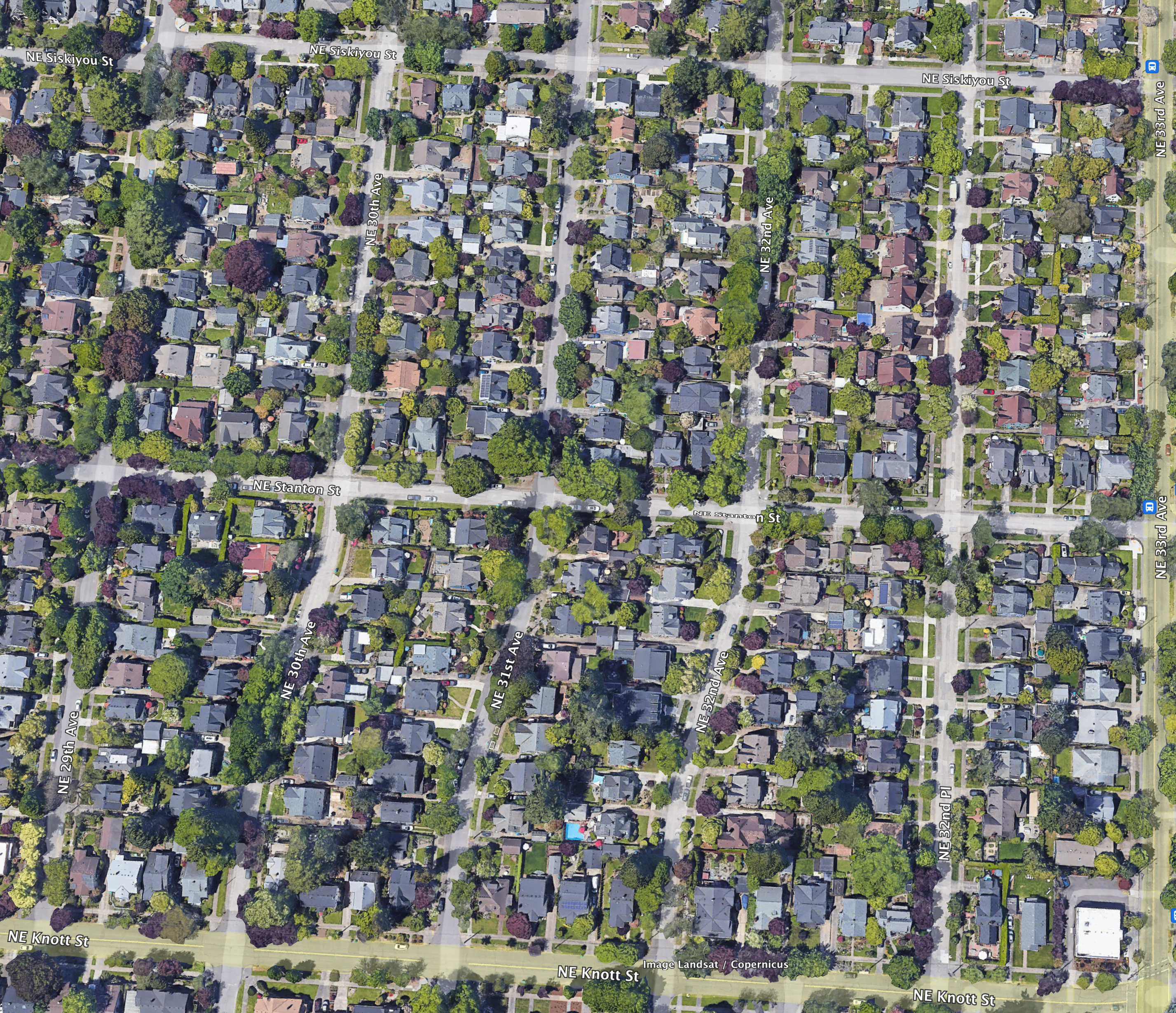
Google Earth image showing the area bounded by Siskiyou, 29th, 33rd and Knott which posed major challenges to developers in the 19-teens until the city came up with a simple idea but hard-to-achieve plan. Toward the bottom of the photo, note the curved streets leading north off Knott at NE 29th, NE 30th and NE 31st.

Understanding Plats and Subdivisions

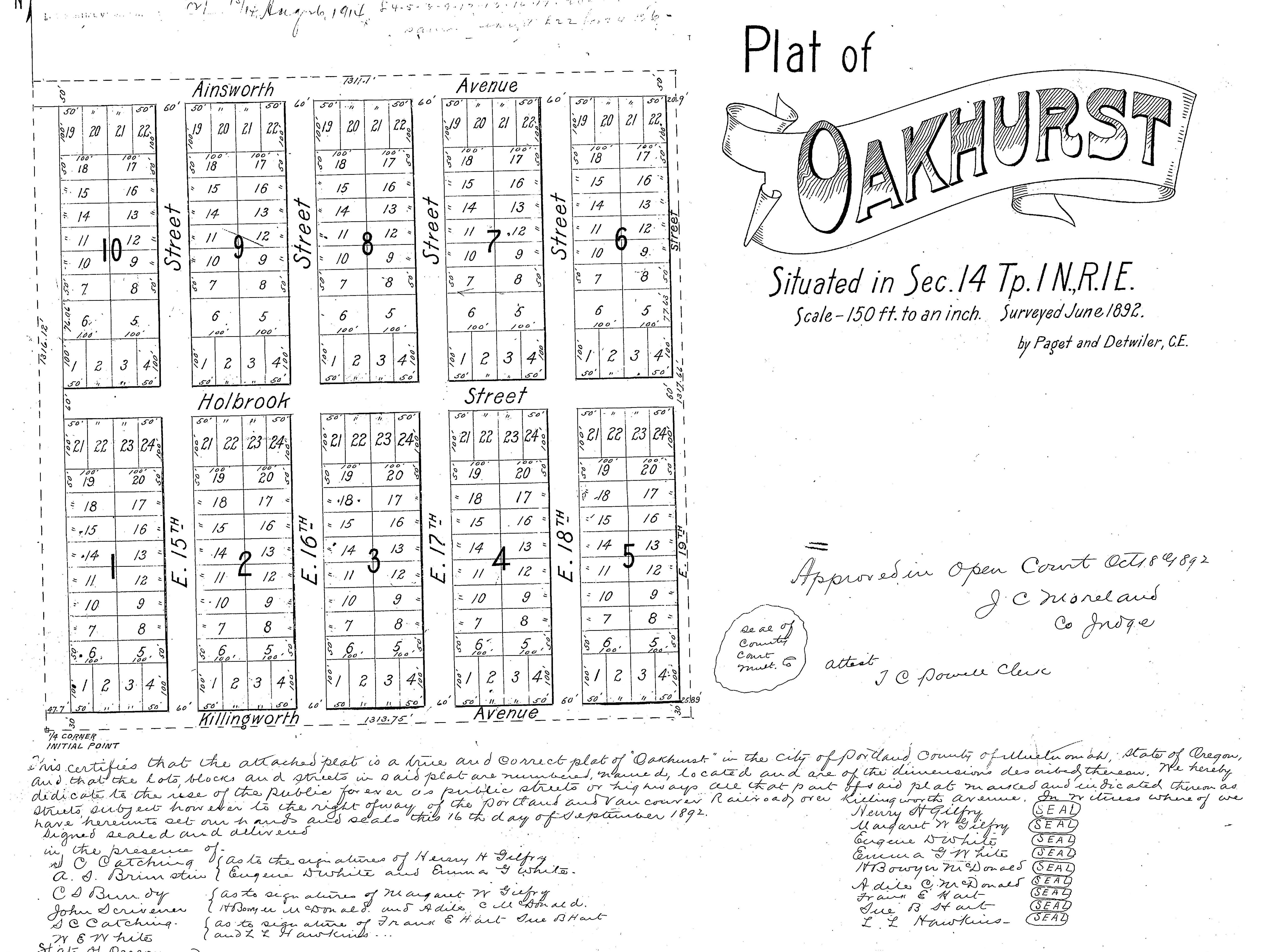
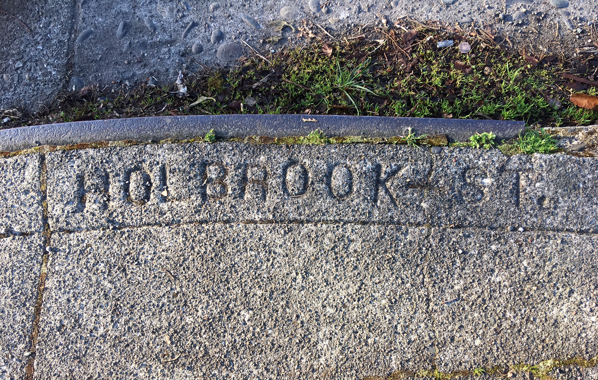
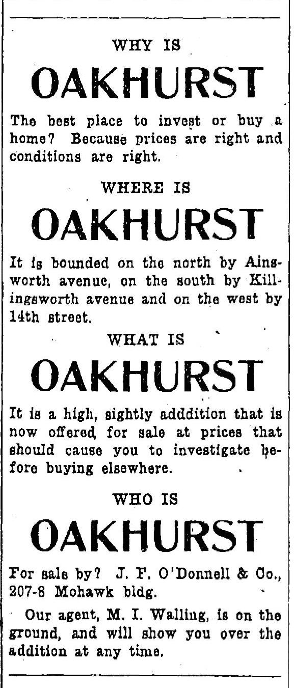
To understand what happened here, it helps to know about plats and subdivisions, which are different than actual neighborhood names. Portland is made up of more than 900 plats. A plat is a localized engineering plan and legal survey for development of a subdivision that shows the precise location of streets and lots. Back in the day developers gave these plats names that would catch a prospective home buyer’s eye, or that meant something to the developer.

Today’s Alameda neighborhood, for instance, is made up of 23 separate plats, all filed at different times by different developers who were competing with each other and speculating on market conditions when they bought chunks of what had been old homesteads and farms claimed in the 1850s and 1860s. There was indeed an Alameda Park plat (filed in 1909 by the Alameda Land Company), but it’s only one piece of what the City of Portland today refers to as the Alameda neighborhood. 22 other subdivision plats—with names now lost to time except on property legal descriptions—make up today’s neighborhood.

Here in today’s Alameda we’re made up of the following plats: Alameda Park, Olmsted Park, Meadow Park, Linlithgow Park, Homedale, Irvington, Irvingdale, Irvingwood, Edgemont, Charleston’s Addition, Pearson’s Addition, Stanton Street Addition, Hudson’s Addition, Gile Addition, Town of Wayne, Town of Wayne Replat, Quinn’s addition to Town of Wayne, Waynewood, Dunsmeade, Hillside, George Place, Bowering Donation Land Claim Tract, Norton’s Subdivision, and Gleneyrie. Phew. All filed by different owners/developers with the county surveyor in the 40 years between 1882-1922.

Remembering the deep history of these lands

Going back in time, it’s important to remember that before these lands were claimed as homesteads by the first white Euro-American arrivals, the federal government forcibly dispossessed the area’s indigenous people from these lands. All of us in the Portland area live today on lands ceded to the U.S. by Chinookan tribes and bands; their former home lands since time immemorial. Read more about this deep history here.

This area was part of the City of East Portland until 1891

The east side wasn’t actually Portland until after 1891, it was East Portland, a separate city. Prior to that, we were three separate cities sharing some limited common infrastructure, but with different character and focus: Portland (on the west side of the river), East Portland and Albina.

In 1891—in an attempt to roll together the greater Portland area population into one number that would intimidate rival Seattle which was growing fast—the three towns consolidated into one (46,385 people in Portland + 10,000 people in East Portland + 5,000 people in Albina = 61,385 people total in the Portland “metropolitan” area). Take that, Seattle (total 1890 population: 42,837).

There had been a boomlet of development about the time the transcontinental railroad arrived in Portland in the spring of 1882, when some plats were filed in East Portland including “The Town of Wayne” plat in the heart of today’s Alameda. After the Lewis and Clark Centennial Exposition in 1905, which put Portland on the map, a bunch more plats were filed, and then again during the 1920s, after the pandemic.

But let’s get back to the bends.

Too many disconnected plats – a real estate collision

Think of this accident of time as a kind of real estate development collision. The helter-skelter nature of platting before we became part of Portland—fueled in part by spikes in the real estate market which drove owners to create small, disconnected parcels on paper that were never actually developed—resulted in plats with different types of street and lot layouts. As larger, newer and better-planned subdivisions spread out to divide up more territory, the patchwork northwest corner of 33rd and Knott became a vortex of confusion. The city coined a perfect term for it at the time: misfit platting.

Some plats had alleys, some didn’t. Some had many narrow lots. Some had fewer larger lots. There was only one through street and it had varying widths. Corners didn’t line up. There was no street naming protocol. In short, it was a mess.

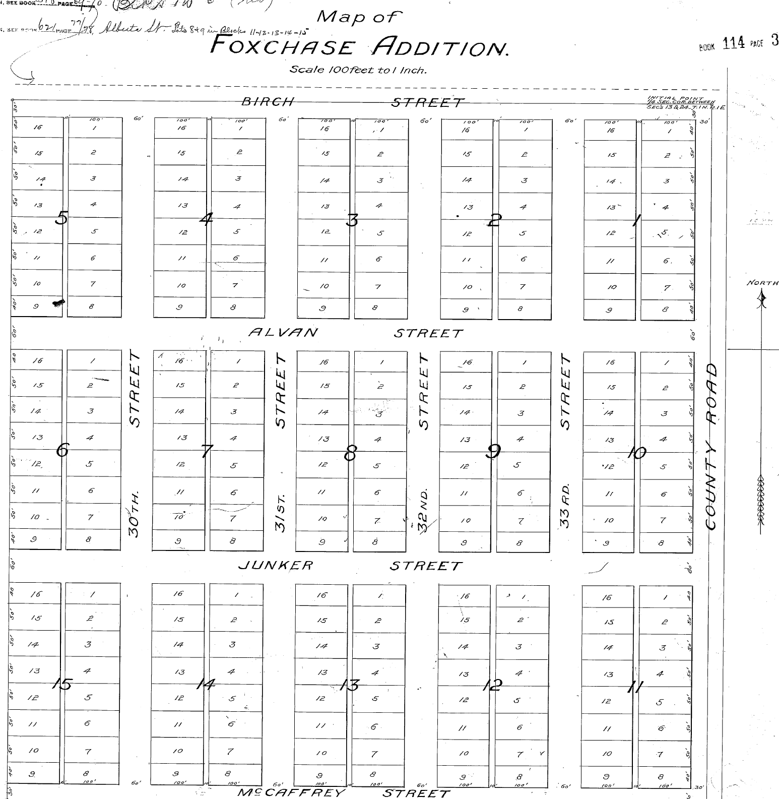
But the area was still just multiple hopeful plans on paper—these were open fields well into the late 19-teens, even though more than 45 owners had already bought in—and people continued buying, holding and even trading lots as a speculative investment. Here’s what it looked like by about 1915:

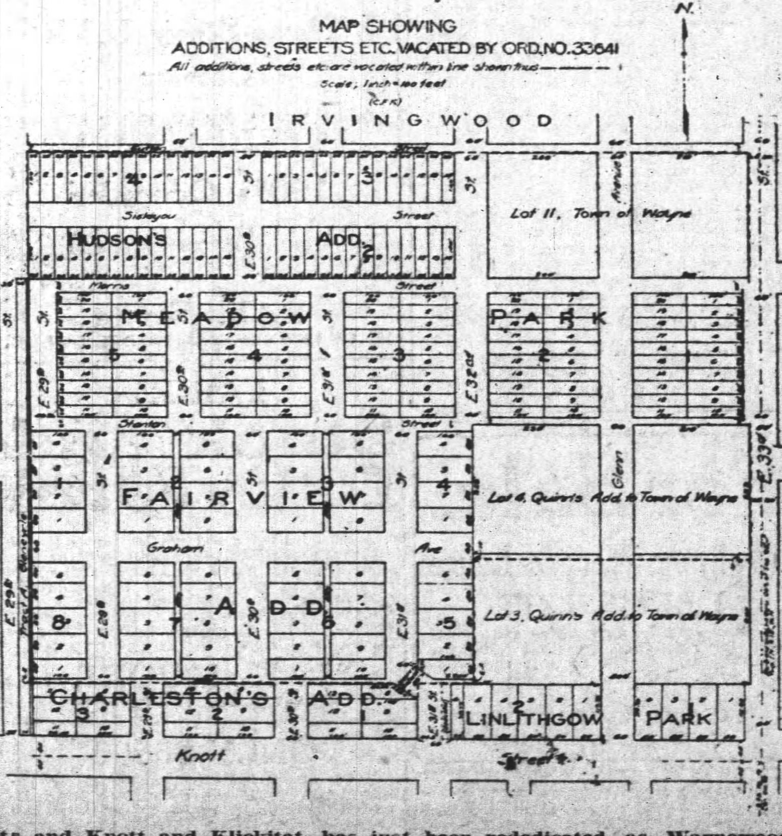
This diagram from the Oregon Journal on May 20, 1918 shows the jumble of plats that used to occupy the area bounded today by NE Siskiyou on the north, Knott on the south, 33rd on the east and 29th on the west. The plats include: Town of Wayne, (1882); Quinn’s Addition to the Town of Wayne, (1886); Hudson’s Addition, (1892); Fairview Addition, (1889); Meadow Park (1890); and Charleston’s Addition, (1895). A careful examination shows that each plat is organized differently. Note that the Fairview Addition even had alleys.

In the early 1910s, with construction and sales well underway in nearby Irvington, Alameda, Beaumont and Rose City Park, developers turned to the next nearby open lands in the pipeline for development and found this total mess.

There was only one real solution that came to mind: Go back to the drawing board and replat the whole area, something never done on this scale (and perhaps never since). But how you do that with specific lots already owned by dozens of hopeful investors in planned subdivisions that had been legally filed and on the books for as long as 30 years?

You see the problem now.

It first surfaced in the newspaper in February 1915:

From The Oregonian, February 12, 1915

The problem percolated among the property owners and the city engineering office for a while until they developed an ambitious plan about how to proceed:

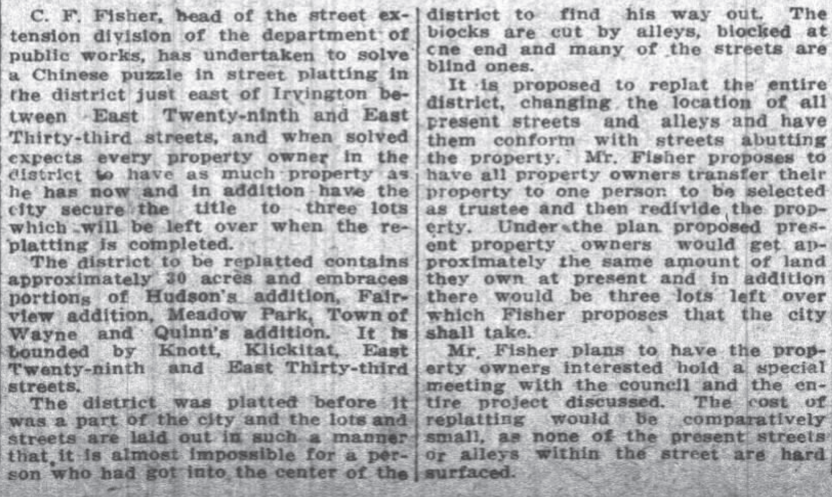
From the Oregon Journal, June 20, 1915

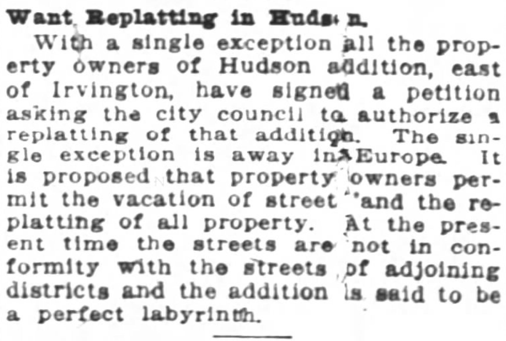
Fisher’s meeting with the property owners went well and all but one got on board. A petition was signed a few months later to send a message of good faith to the city. The last line of the article summed up the problem nicely: the addition is said to be a perfect labyrinth.

From the Oregon Journal, January 9, 1916

The city engineers worked with the Title and Trust Company to do the necessary temporary title transfers to a holding trust that would allow a clean slate and then started drawing different lines, keeping everyone whole, eliminating the labyrinth, adding those curves, and retitling every single lot back out of the temporary trust. The result was a brand-new subdivision called Waynewood, a tip of the hat we suppose to the old Town of Wayne plat and the Irvingwood subdivision just to the north.

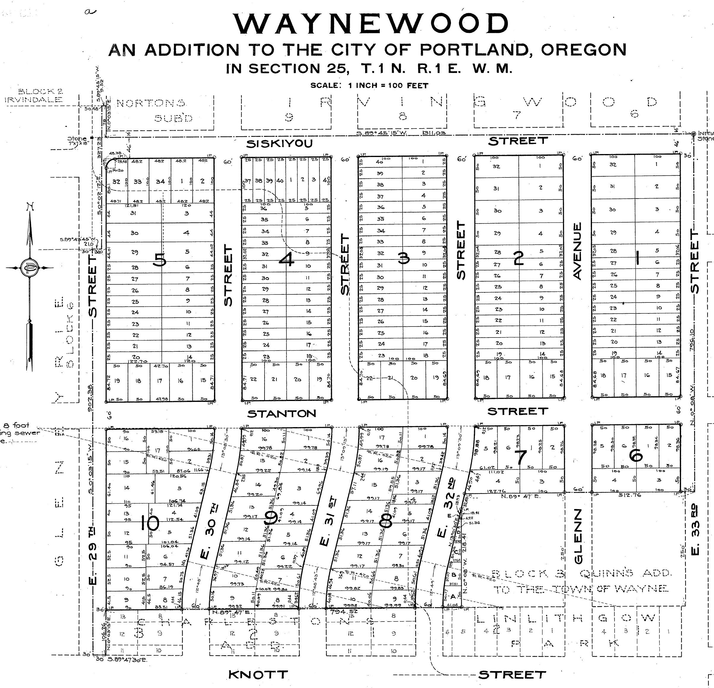
The official plat of Waynewood filed with the Multnomah County Surveyor on February 2, 1918 containing the brand-new retitled lots and redrawn streets. In addition to understanding how the curves came to be, the replatting process also explains the misaligned corner at NE 29th and Siskiyou.

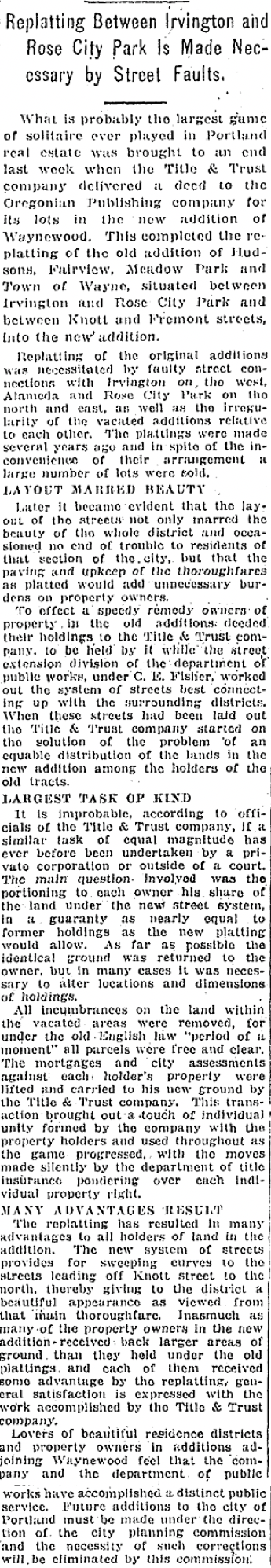
A story in the Oregon Journal on May 30, 1920 explained the process and the benefits:

Today all of the energy and consternation that went into that process is completely invisible to us here in their imagined future (at least until now), our only clues the graceful curved streets that lead north from Knott Street. Those curves are reflected south of Knott as well, but they came later when the subdivision known as Dolph Park was platted in 1924, and that’s another story.

If you like neighborhood history puzzles like this as much as we do, check out the Prescott Jog, the Ainsworth Long Block, the Ghost of Crane Street and remembering Laura Hamblet.

A little more on Oakhurst

Our recent post about the corner of NE 15th and Killingsworth produced memories and comments from a number of AH readers which we were pleased to see, including a request for a bit more about Oakhurst, which we’re glad to oblige. Learning about these many plats/subdivisions is enlightening.

Here’s the original plat, filed on September 16, 1892 by a handful of real estate speculators who had their hands in multiple subdivisions all over town. Click on this to have a good look, we know you are going to have some observations and questions:

Detail of the official Oakhurst plat on file with the Multnomah County Surveyor. 

First, you’ll notice the fashionable graphic banner sporting the name. We’ve looked at hundreds of plats and have to say this is the most attractive graphic we’ve ever come across on a formal, dry plat document. Particularly from the 1890s.

Next you’ll note all of the partners (and this is quite a crowd of partners), surveyors, commissioners and notary passed over the misspelling of Killingsworth. It was never “Killingworth.” They knew better. So much for attention to detail.

You’ll also note there is no Jarrett Street: it shows up here as Holbrook Street. In fact, if you go looking, you’ll find Holbrook Street stamped into the curb at the northwest corner of NE 15th and Jarrett, even though it doesn’t exist.

A now-extinct street name, set in concrete at NE 15th and Jarrett, April 2017.

In fact, when the sidewalks were poured in 1911-1912, Holbrook Street had been off the books for four years. Was the cast-in-concrete mistake really a mistake, or do name changes just take a while to settle in among the locals?

Merritt L. Holbrook was a realtor, banker and developer who worked in north and northeast Portland. The street name was changed by city ordinance on August 23, 1907, no particular reason given. Here’s our hunch: Jarrett Street already existed starting in today’s Arbor Lodge neighborhood and running east. As it passed through the Oakhurst plat, Holbrook was offset just a half block south. It was probably just easier to call it all one street than to have a short segment known as Holbrook.

Jarrett, by the way, was Mark L. Jarrett, who owned property west of Oakhurst, and who platted his own 25-square-block subdivision between Ainsworth and Killingsworth, from North Michigan to the alley behind North Commercial called Jarrett’s Addition. Jarrett died unexpectedly at age 30 in October 1888 from smallpox while visiting family in Virginia and his estate—without a will—went through an ugly, drawn out probate process that makes for interesting reading in its own right, but doesn’t bear on Oakhurst.

When you immerse yourself in the newspapers of the early days of Portland’s land boom (1890-1920) you quickly see a pervasive web of bankruptcies, lawsuits claiming money owing, delinquent taxes, land transfers and settlements. It’s clear these early speculators platting this open land were barely staying one step ahead of paper and financial obligations owed to someone else. Elsewhere in the newspaper, they appear together on the society pages being jovial, leading outings and picnics together, playing tennis, attending operas, lectures, teas and dinner parties, traveling to the coast or back east.

Oakhurst’s incorporators are a perfect example: Henry and Margaret Gilfry (he the long term clerk of the U.S. Senate); Eugene and Emma White (he a realtor as well as the bond guarantor who bailed out J. Carroll McCaffrey of Foxchase fame on fraud charges, shake your head now); H. Boyer and Adile McDonald (he a real estate and life insurance salesman); Frank and Sue Hart (also real estate and insurance). By 1903 all of these individuals had been sued by their mortgage holder Portland Trust Company for taxes owing on vacant lots in Oakhurst. A couple of them paid, most of them didn’t and the lots were then transferred to Ainsworth National Bank (L.L. Hawkins, president…note his name as an incorporator on the plat…. a friend, neighbor and Portland socialite). It was a very small world.

So there’s the history of the Oakhurst plat’s early days. Most of the land remained unbuilt well into the early 1900s, just curbs and streets. As Portland’s population boomed after the 1905 Lewis and Clark Exposition, lots were bought, houses built and Oakhurst began to come to life. Specific newspaper references to Oakhurst as a place begin drop off after these early years, though we know at least one pharmacist who thought the name would bring him business.

Detail of a classified ad from the November 4, 1906 edition of The Oregonian.


Northeast Portland’s Foxchase: What’s in a name?

If we asked you to find Foxchase on a map, could you?

Here’s a clue: it was one of a dozen different subdivisions created more than 100 years ago that taken together today make up what we think of today as northeast Portland’s Concordia neighborhood.

Here’s a visual clue: then-and-now photos of the same place, separated by 63 years.

Then: Looking east on NE Killingsworth at 30th Avenue, 1954. Note stop signs faced traffic on Killingsworth. The building with the striped awning is today’s Cup and Saucer Cafe. Photo courtesy of City of Portland Archives, reference A2005-001.365.

Now: NE Killingsworth and 30th Avenue looking east, March 2017. Lots of change in this photo: the Shell station on the northeast corner (which we knew for years as a U-Haul rental place) has been replaced by a type of massive apartment block that has become ubiquitous on Portland’s eastside.

Here is the other then-and now pair:

Then: Looking west on NE Killingsworth at 30th Avenue, 1954. How about that stop sign? By the time this photo was taken, the Alberta Streetcar that traveled down NE 30th Avenue to Ainsworth had been gone six years, but the “through street” mentality was still more with 30th than with Killingsworth. Photo courtesy of City of Portland Archives, reference A2005-001.366.

Now: NE Killingsworth and 30th Avenue looking west, March 2017

An unscientific survey taken on a Friday morning walk with the dog turned up the fact that most local business owners at the increasingly busy intersection of NE 30th Avenue and Killingsworth know they are in Foxchase. There are some Airbnb’s in the area identifying themselves as being in “Fox Chase.” And maybe a few residents who think of themselves as Foxchasers too. But chances are if you tell a friend “I’ll meet you in Foxchase for a beer,” they’re going to need directions.

So when we came across the 1954 photos recently and were already doing some serious digging into how the Foxchase plat came to be—and it is a fascinating story—we thought it was time to set the record straight with a little history.

First of all, it’s Foxchase. That’s what the plat says, filed on April 1, 1889 by Eugenie M. and J. Carroll McCaffrey. Here it is:

Foxchase Detail 1889

Only the numbered streets retain their identity today. McCaffrey = Alberta. Junker = Sumner. Alvan = Emerson. Birch = Killingsworth. The intersection of NE 30th and Killingsworth anchors the northwest corner.

The 1889 Foxchase plat was actually filed in the town of East Portland. At that point we were a separate city distinct from Portland, as was Albina and several other outlying communities. In 1891—in an attempt to roll together the greater Portland area population into one number that would keep us ahead of Seattle—the three towns consolidated to became one (46,385 people in Portland + 10,000 people in East Portland + 5,000 people in Albina = 61,385 people total in the Portland “metropolitan” area). Take that, Seattle (total 1890 population: 42,837).

Not long after platting the property, J. Carroll McCaffrey started running classified ads in The Oregonian and the land speculation boom was on.

From The Oregonian, February 19, 1890. McCaffrey set up the Western Oregon Land and Investment Company for his real estate deals.

Dozens of Foxchase real estate transactions show up in the early 1890s. All speculation: the buying and selling of lots.

At that point in our history, there wasn’t much up here on these gentle slopes of the Columbia Slough and the Columbia River beyond. Fields, forests, a few dairies here and there; Homestead Act claims from the 1860s held by a couple dozen families. Alberta was a dirt track meandering 10 blocks between MLK (Union Avenue then) and what is today’s NE 15th Avenue. Across the Willamette River, the small grid of what we think of as downtown Portland was getting ready to explode, and investors like McCaffrey knew it. His business was to use other people’s money to buy up open land for the eventual grids of streets and lots that would follow.

Here’s where the story gets interesting.

J. Carroll McCaffrey was a Georgetown-educated attorney, born and raised in Philadelphia, who kept a small practice there as well as here in Portland. He and his wife Eugenie were busy on the social scene of both communities and frequent travelers back and forth.

They showed up in Portland about 1886 and McCaffrey quickly became ingratiated with Portland business leaders as a likeable and cheerful person. That fall and through the winter of 1887, J.C. placed the same advertisement in The Oregonian almost every single day:

McCaffrey found what he was looking for and was quickly engaged in the development of Portland Heights (southwest Portland), being quoted in the newspaper about the availability and quality of artesian well water in the southwest hills, helping incorporate the Portland Cable Railway Co. to transport people up to the heights, and building a prominent mansion known today as the Markle House to entice development.

At the same time as he was speculating on property in the southwest hills, McCaffrey looked to the east side guessing Portland was headed that direction too. He acquired a majority interest in a 15-square block portion of what was the larger 160-acre Donation Land Claim of George Emerson. He and Eugenie platted these 15 blocks as Foxchase.

Here’s where the Philadelphia connection comes in. Fox Chase is the name of a comfortable neighborhood in northeast Philadelphia, named for an 18th century inn. During McCaffrey’s timeframe of reference—the 1870s-1880s—Philadelphia’s rich and famous were building their mansions in Fox Chase. He and Eugenie were trying to call that to mind.

Their choice of street names hit close to home too: Because Alberta didn’t exist except in the Albina area, they planned for that main street on the south end of the plat to be McCaffrey Street. Junker, the next street to the north, was Eugenie’s maiden name. Was Alvan the nick name for one of their four young children? And Birch? Hmm, no birch in that area. Choose any nice tree name.

McCaffrey liked what he saw in the land speculation business, and in 1890 incorporated as the Western Oregon Land and Investment Company (that’s his company in the 1890 classified ad up above). He was just getting rolling.

But not long after that, things started to fall apart. McCaffrey unsuccessfully sued his former partners in the southwest Portland cable railway enterprise and George Markle, who bought the mansion McCaffrey had built on Portland Heights. In 1892 McCaffrey was arrested for land fraud related to 80 acres he was trying to sell south of Oregon City, charges he wriggled out of on a technicality. In 1893 he was charged with embezzlement, which he tried to shrug off as a misunderstanding and escaped because of technicality related to evidence. That same year he was accused of fraud by two of his fellow members of the Chamber of Commerce. And, Eugenie was granted a divorce citing inhuman treatment.

When he was indicted on check fraud in February 1894, The Oregonian reported that in a period of a few years, McCaffrey had been remanded to a grand jury on a dozen fraud charges of various types. He was no longer able to secure a bondsman to keep him out of trouble, and business must have gotten tight as people discovered he was not a man of his word. Eventually, McCaffrey was convicted of check fraud and served a few months in the Oregon pen before winning on appeal on a technicality, when he fled to his native Philadelphia to resume his legal practice.

Here’s where it gets stranger than fiction (a small reward for those of you who have stayed with me this far): In 1895, McCaffrey was hired by the defense team of serial murderer H.H. Holmes (made famous in the book The Devil in the White City…about the “murder castle” near the 1893 Chicago World Fair) to try to persuade Pennsylvania Governor Robert Pattison and the Pardon Board to stay Holmes’s execution. We know McCaffrey was a persuasive attorney when it came to appeals, but not this time. Several months later, McCaffrey took his own life.

So, it’s probably OK McCaffrey Street never made it to the map. And interesting that Foxchase is making a comeback, though some still think of it as the northern part of Concordia.

We’ve written here before about the distinction between subdivision or plat names and neighborhood names. Most plat names have disappeared into the fog of the past, no longer used or even known by neighbors who occupy them every day. Plat names were provided by developers when they extended their portions of the grid into the fields and forests that were here before us. Just like the McCaffreys did, developers tended to choose plat names that sounded attractive or that called to mind the suggestion or essence of a special place.

Some of our favorites that exist invisibly under our feet here in northeast Portland today are Manitou, Railroad Heights, Spring Valley Addition, Town of Wayne, Durant’s Nightmare (yes, that’s a real plat name…referring to the nightmare the surveyor had in getting all the survey lines to meet up).

Long live Foxchase.

Figuring out the Prescott Jog

AH readers know we like nothing better than a good history mystery, so we were intrigued when a reader asked recently about why NE Prescott makes a jog south between NE 33rd and NE 37th. In this case there is no one single reason: it’s multiple reasons related to changes in surveying proficiency, the passage of time, the helter-skelter nature of developers operating at the edge of the city limits in 1900, and a complete absence of planning in our turn-of-the-last-century city.

The Prescott Jog near 37th

The jog at NE Prescott and 37th

Let’s look at the basic ingredients:

The Grid: Back in 1850, surveyors used a grid to map Oregon and to organize our landscape into big boxes and small boxes, known as townships, ranges and sections. In Northeast Portland, our main east-west streets are organized on section or half-section lines. Prescott (all but the four-block stretch we’re talking about here) rests on a half section line.

The Plats: Portland has more than 900 of these: a plat is basically a plan that divides the land into lots and streets. Developers were in charge of their own plats, and gave them unique names, some of which are pretty interesting. A plat called “Willamette Addition,” drawn and filed in 1888, contains the area from Skidmore to Killingsworth and from NE 33rd to NE 37th. Of particular note: running along the bottom of that plat is our mystery stretch of Prescott between 33rd and 37th.

So here’s what happened:

The Willamette Addition was anchored on the south boundary to what in 1888 was thought to be the half-section line (the future Prescott). Actual development of the Willamette Addition didn’t happen until the 1920s, and in many cases much later.

Our maps pages shows both Alameda Park (the neighboring plat to the west, 1909) and Wilshire (the neighboring plat to the east, 1921), which were laid out decades later by different developers using different survey technology. And guess what: the location of the real Prescott (in alignment with the more-recently-surveyed half-section line) moved about 75 feet to the north.

But meanwhile the Willamette Addition was still just a drawing and raw land owned by different developers, with it’s weirdly offset four-block southern boundary, which was referred to as Columbia Street, stuck on the grid of 1888 and quickly becoming irrelevant. The developers of Alameda and Wilshire weren’t in control of the Willamette Addition, but they had to build streets around it and needed to tie their new neighborhoods into the actual half-section-line-based street we know today as Prescott. So, build they did, marooning this yet-to-be developed four-block stretch of “Columbia Street” 75 feet to the south, and necessitating eventual construction of the s-curve jogs we know today when development of the Willamette Addition finally followed years later.

There’s a story behind everything. That’s why we love history!

%d bloggers like this: