Oregon Home Builders: A Company History, 1912-1917

The story of the Oregon Home Builders is one of a big vision that ended in bankruptcy and likely even unprosecuted fraud. But it’s also a story of productivity and lasting accomplishment, with works of careful design and craftsmanship that have survived a century.

Founded in 1912 by a group of established Portland and Willamette Valley businessmen, OHB’s primary mission appears to have been to make a lot of money, to use as much of other people’s money as possible to do that, and to benefit from skyrocketing growth in real estate and in-migration to the Portland area in the years following the 1905 Lewis and Clark World’s Fair, which had put Portland on the map.

Officially, the company’s prospectus, published in 1912 in a slim, attractive hardcover book, put it like this:

“Early in the year 1912, a number of successful Portland business men, confident of the wonderful future of the metropolis of the Pacific Northwest, organized The Oregon Home Builders for the purpose of purchasing, developing, sub-dividing and selling real estate in and around the city of Portland and to finance and build modern homes on its own tracts for sale on monthly payments like rent… to participate in the golden harvest to be reaped in Portland through its certain growth, prosperity and development within the next few years.”

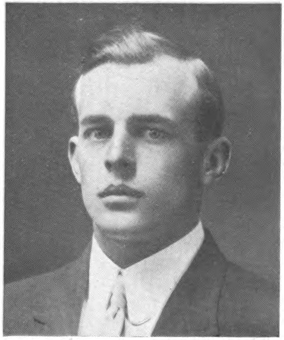
Consider the primary organizers of the company: the chief attorney and the general manager of Portland Railway Light and Power, which was building the essential and widespread transportation system that enabled Portland’s eastside expansion; a leader of the Portland Retail Merchant’s Association; the president of a major lumber company; several bankers and accountants; one of the leading automobile dealers of the day; a charismatic and successful 24-year-old real estate broker from a prominent Portland family named Oliver King Jeffery (who also happened to be related to the bankers and accountants). Add in a few other friends and relatives: a successful farmer from the Newberg area, the former mayor of Newberg, and a captain of heavy industry from back east (also related).


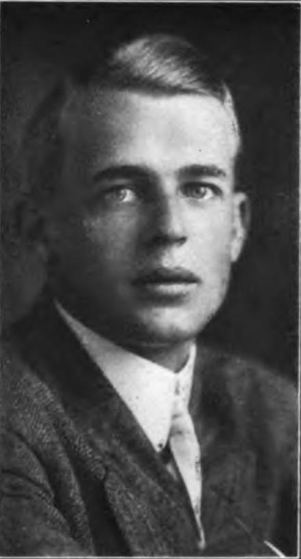
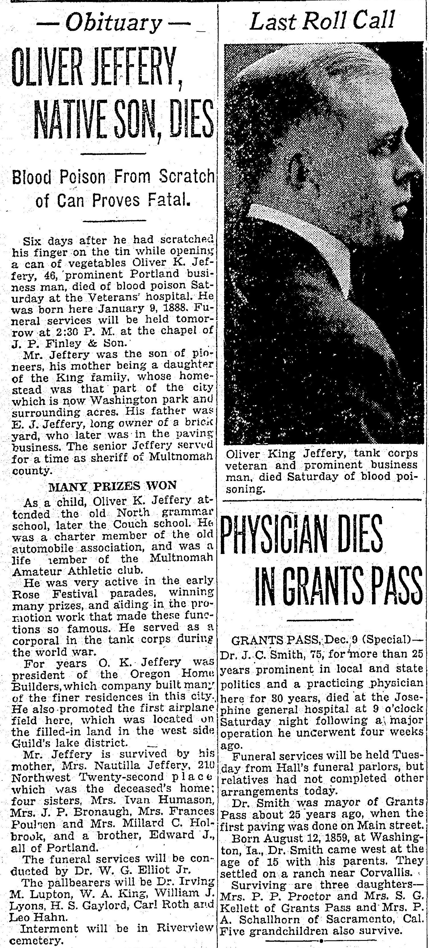
Oliver King Jeffery, 1916
From the Photographic Business and Professional Directory, American Publishing Company, 1916.


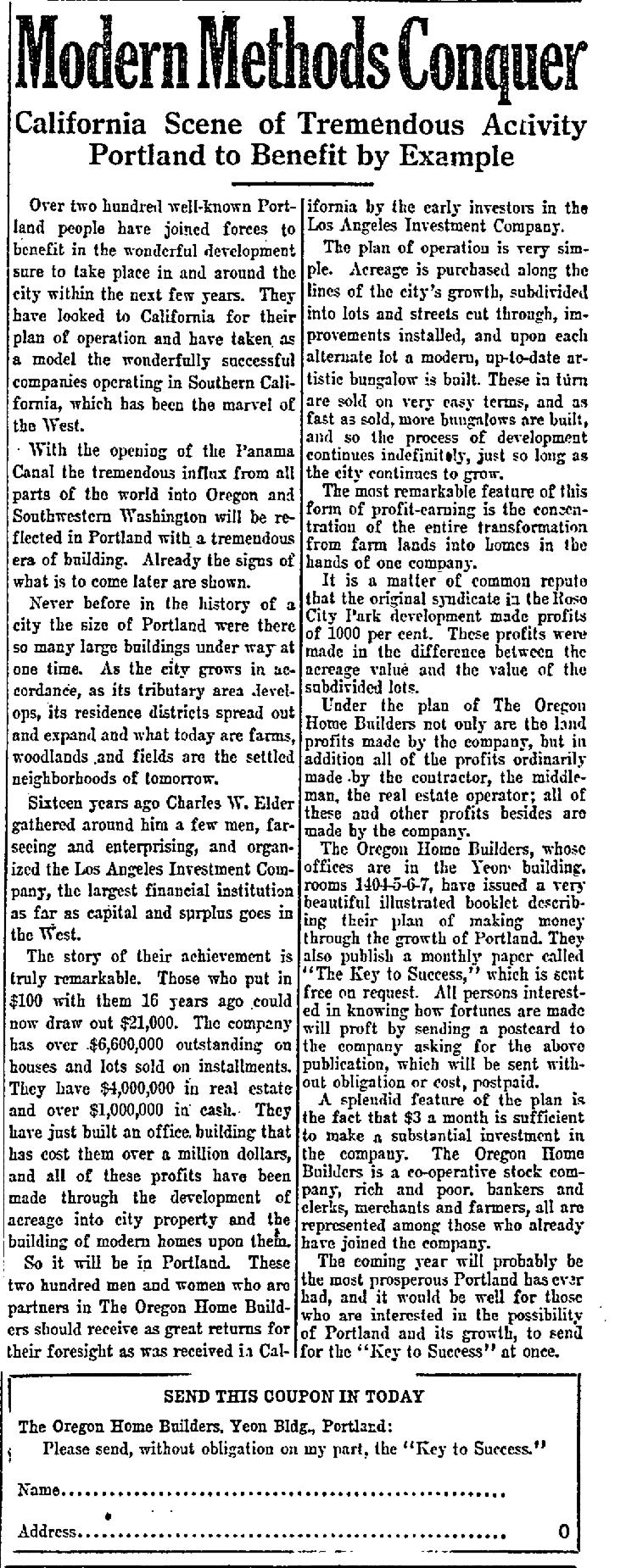
This group incorporated in early 1912 as the Oregon Home Builders with Jeffery as its president and a borrowed corporate strategy from the Los Angeles Investment Company, led by Charles A. Elder, who was known at the time across California as the “King of the Homebuilders.” Elder’s company had become that state’s most prolific builder of homes, arranger of financing and developer of real estate.

OHB liked what it saw to the south and structured itself much like Elder’s company, where investors put up the money to start and fuel operations by buying stock that would turn to profit once the company started actually selling homes. Following several trips to L.A. to witness Elder’s success and methods, new president Oliver K. Jeffery returned to Portland fired up and ready to raise capital.

Multiple references to the California approach, and the math of its investments, were quoted liberally in the original 1912 OHB prospectus, as was this perfect description of what was happening across Portland’s eastside:

“The development of suburban acreage into city property is one of the surest forms of profit earning known. In every growing city there are a number of people who have had the foresight to anticipate the growth of population and the consequent increased demands for housing facilities. As a city grows, spreads, expands in each direction, new neighborhoods spring up, farms are cut up into lots, streets cut through, sidewalks and city improvements installed, homes built, stores, churches and schools are established, and as if by some magic wand, what but a short time before was a truck farm or woodland, or field, is soon an integral part of the city: and in this transformation men and women have made fortunes.”

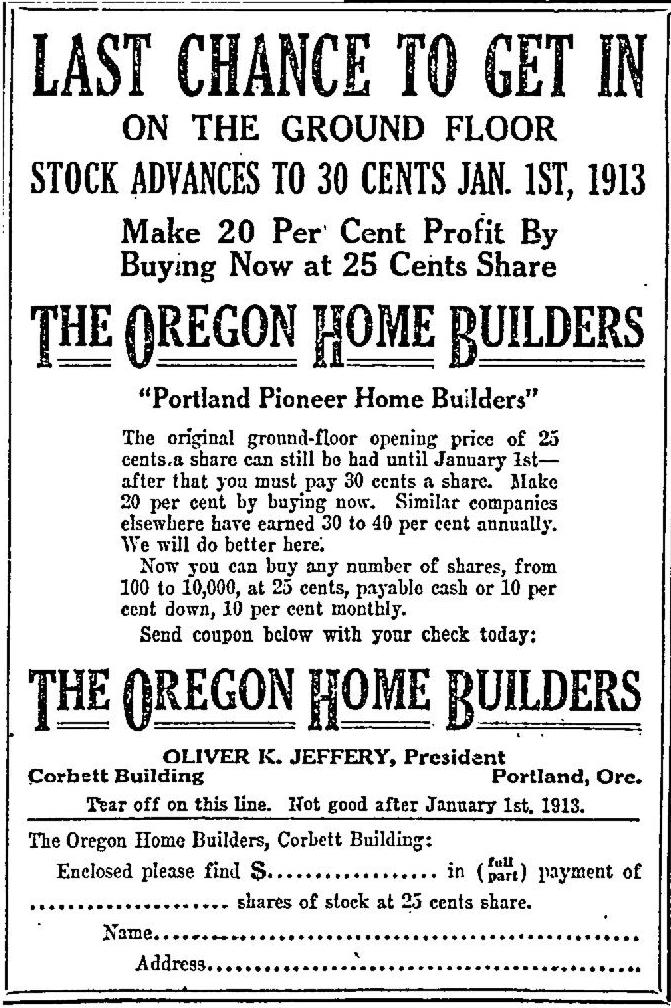
Oliver K. Jeffery was prominent in the Portland social scene as a leading Rosarian, later credited with inventing the Rose Festival Parade, and even at age 24 had helped build the successful commercial and residential real estate firm of Keasey, Humason and Jeffery. His family owned and developed much of the King’s Heights area on Portland’s westside (his mother Nautilla was a daughter of the King family). So when he started talking about real estate, people wanted to listen. Here’s the grand plan Jeffery spelled out in The Oregonian on February 9, 1913 as a paid advertisement. Note the reference to 1000 % profit, an early signal of the group’s underlying intention.

From The Oregonian, February 9, 1913


As it tried to create a financial head of steam, OHB’s early advertising push was marked more by pitches for investment and financial return than anything actually related to home ownership or home building, but that would follow once the company had sufficient assets to make the thing go. Here’s a sample of what OHB told readers of The Oregonian and The Daily Oregon Journal on a frequent basis in 1912-1913.

From The Oregonian, December 29, 1912


Pitches like this must have been successful because by 1915, OHB was reporting it had more than 1,000 stockholders from across the state. The company’s vision for what it was trying to create—which seemed in its early days to be mostly about selling stock, not houses—was evident in this help wanted ad it placed for more salesmen:

“Large corporation can use bright, active salesmen in every city in Oregon and Washington to sell the best home building stock offering ever submitted. The profits to the investor are very large.”

Once capitalized, OHB did start buying property in what it termed “first class” subdivisions being platted like Laurelhurst, Alameda Park and Olmsted Park, and it concentrated particularly near streetcar lines. It even bought and sold some home properties at the coast, where Jeffery had been active as a real estate agent before OHB. In the first two years, the company also relocated its offices twice, from the 5th floor of the Corbett Building to the 14th floor of the Yeon Building, and then finally to a prestigious suite of offices on the 13th floor of the Northwest Bank Building (known today as the American Bank Building, 621 SW Morrison).

And then in 1913, encouraged by a rising local economy, OHB began building homes.

At the bottom of this article is a partial list by year that we’ve gleaned from reading every entry about the company in The Oregonian and the Oregon Journal between 1912-1921, and from a study of building permits we completed in 2010.

OHB’s principal architect during the early years was George Asa Eastman whose talent is still visible today in the homes he designed. Eastman was born in Albany, New York on January 16,  1880 and arrived in Portland in 1900. He worked for a time as a salesman, window dresser and furniture designer, marrying Lillian Key Brooks in 1906. City directories from 1911-1916 list him as an architect. During those years Eastman kept a busy practice of his own as architect and homebuilder, but he also worked for OHB. Eastman traveled in social circles with both Jeffery and Edward Zest Ferguson, president of the Alameda Land Company, which developed the Alameda neighborhood.

Eastman’s early work is notable for its Craftsman and Prairie School influence. Check out the Zimmerman-Rudeen House at 3425 NE Beakey; the George and Lillian Eastman House at 2826 NE Stuart, which he designed and lived in; 2747 NE 18th; 2442 NE 24th; 2803 NE 24th; 5620 NE Cleveland; 2334 NE 25th, 49 Briarwood Court, Lake Oswego. All of these bear strong family resemblance. Three of his homes in Northeast Portland are on the National Register of Historic Places. He was a talent.

George and Lillian Eastman home, 2826 NE Stuart. Designed and built by Eastman in 1912. He and his family lived here from 1913-1915 before moving to Detroit, Michigan where Eastman worked for Associated Builders Co. before his untimely death in 1920 at age 40.


Perhaps Eastman saw the writing on the wall here in Portland: he and Lillian and their two children George and Virginia left in 1916 for Detroit, Michigan where the design and building of high-end homes was going strong. Eastman’s architectural career was brief: he died on January 25, 1920 and is buried in Birmingham, Alabama—Lillian’s hometown—where Lillian, George Jr., Virginia, and infant daughter Jane moved following George’s death.

After Eastman left Portland, architect Max Meyer took over briefly as lead architect for OHB, before leaving to start his own private practice in 1917, where he advertised himself as “formerly with Oregon Home Builders,” signaling the company’s lingering cachet even after it eventually closed its doors.

On the construction side of the business, many of the city building permits taken out by OHB had H. Riley Linville’s name on them, who for a while was chief plumber and partner in the Linville-Myers Plumbing Co. The full list of carpenters, laborers, day workers, superintendents and other OHB employees remains unknown.

These building professionals knew what they were doing. In 1915 they built a conveniently located workshop and warehouse at NE 33rd and Broadway, which in late 1916 was expanded into the building on that corner we know today as the former Gordon’s Fireplace Shop which later figured in another very brief but failed Jeffery vision known as the aircraft factory. Little more than a big shed at first and then later a full three-story building with milling equipment, that corner was a manufacturing hub for built-in cabinets, shelves, window and door casements and furniture that went into OHB homes. And they just kept building houses, often multiples in a block bought by OHB, and for individual clients who had picked a particular home design from their catalog. Some were modest and run of the mill. Others were show houses.

From The Oregonian, June 10, 1917. The house above is at 2931 NE Dunckley; below is 3024 NE Bryce. Both built by OHB. All of Portland was readdressed in 1931.


During these busy years, Oliver K. Jeffery weighed in—part company president, part civic booster and part confidence man—with content and quotes that were curiously well placed in the paper’s news reporting on the days when OHB ads appeared elsewhere in the paper. This was not an uncommon phenomenon in early journalism at The O, which ranged well beyond the real estate pages. Here’s a sample:


From The Oregonian, May 14, 1916

As OHB matured in its short five-year lifespan, the company added employees and different business lines, mimicking its California role model. Ads listed the company’s busy organizational structure: “Architecture Department, Construction Department, Real Estate Department, Land Sales Department, Rental Department, Repair Department, Loan Department, Financial Department, Insurance Department.” They even produced a monthly newsletter called “Keys to Success” which was sent to all stockholders. In one flashy newspaper advertisement, Jeffery boasted that OHB was the largest and best homebuilder in the Portland area. Discreetly placed classified ads sought additional salesmen:

“Energetic hustler who has ambition and desire to locate permanently with rapidly-growing institution. Splendid future to the right party. The Oregon Home Builders, 1330 Northwestern Bank Building.”

Other discreet ads, usually in the “Loans Wanted” classified section like this one from 1916, showed the company was still trying to find more money:

“Want $20,000 private money at 7 percent, best security offered. Financial Department, The Oregon Home Builders, 1330 Northwestern Bank Building”

For a time, the company contemplated creating a plans and kit home department like Charles Elder had in California. In late 1915 OHB produced an 86-page catalog of home designs called The Home Beautiful Book: “The best home plan book on the market” (which we have searched and searched for but never seen). In August 1916, Jeffery put his expansion ideas into words:

“We operate our own warehouse and mill for the construction of the built-in features of the homes we are building. These same facilities will permit us to build ready-built houses for export, about which we are having a flood of inquiries especially from the warring nations where labor is at a premium. We can take care of this business without additional investment in equipment and it will give us the opportunity to buy thousands of feet of additional timber for manufacturing these as soon as we can get the ships to deliver them. It means employment for several hundred more skilled workmen right here in Portland and the resulting increased demand for homes for these men.”

Playing against type, in 1915 OHB launched a rental department and brought in a high-powered rental agent from St. Louis named G. Gilbert Rohrer, who lasted about 12 months before leaving to start his own company. Given Jefferey’s expressed bias for home ownership, Rohrer may have never felt quite at home managing rentals at OHB. But as Portland’s building and buying economy began to slow down, the rental economy stayed strong and the company wanted to keep a hand in the rental business. After all, a percentage of home renters did become home buyers. Rohrer was replaced by John A. Gravley.

In 1915, OHB built a home in Olmsted Park for its cashier and treasurer. C.D. Lehmkuhl (pictured below). The beautiful colonial-bungalow style seven-room home at 3215 NE Dunckley has had an open wooded lot to its west for more than a century:

From The Oregonian, October 3, 1915


The peak of the company’s short life may have come in 1916 when OHB’s lead architect George Eastman designed and built a custom home for Jeffery and his wife Margaret: the three-story Dutch Colonial Revival that still stands at the corner of NE Bryce and NE Regents. The company had hit its stride: it was capitalized (or seemed to be), had a system for production and track record of well-made homes, and was extremely well networked. The new Jeffery home would be a showpiece of just what OHB could do. And it would be highly visible from the Broadway Streetcar line, a beacon to impress would-be investors and potential home buyers.

From The Daily Oregon Journal, June 6, 1915

The house is unique for many reasons, including its sheer scale and size, which is unusual for Dutch Colonial Revival-style homes. Its expansive grounds with reflecting pool and pergola. Its pie-shaped lot, which is actually three individual tax lots. Former residents Ted and Julie Seitz bought and restored it after two decades of decline and hard use and successfully nominated it to the National Register of Historic Places. Quoting from its national register nomination form:

The Oliver and Margaret Jeffrey House is an intact Dutch Colonial Revival design drafted and built by the Oregon Home Builders for Oliver K. and Margaret M. Jeffrey in 1915-1916. This wood-framed, two- and-one-half-story residence is oriented to the southwest and has an unusual cross-gambrel roof form. It has specially milled 10-inch beveled siding, asphalt shingle roofing with attached copper downspouts and gutters, two external granite chimneys, porticoes supported by massive Tuscan columns on its front and west side facades, and a porte-cochere with Tuscan columns on its rear facade.

In an interesting Jeffery family note, in 1920, older brother Edward J. Jeffery Jr., a prominent Portland automobile dealer, moved in to a house within line-of-sight at the northwest corner of NE 29th and Bryce.

Not long after completing the Jeffery House, OHB built another stately and carefully constructed mega-house, this time for board member Thomas Prince, also visible from the streetcar line. This three-story brick Georgian looms over the Alameda Ridge at the intersection of NE Alameda and NE Regents. It’s also deservedly on the National Register of Historic Places, and also an Eastman design. A few years back we visited the Thomas Prince House and shared photos and insights about its early residents which you can read here.

From The Oregonian, July 22, 1917


In addition to the two beautiful houses near Alameda Ridge, 1916 may have been the year it seemed like OHB was everywhere. The company even premiered their own postcards to get the word out that they wanted to build you a house:

Postcard front and back featuring one of the most popular bungalow designs from the Oregon Home Builders, likely the work of George A. Eastman. Courtesy of Steve Dotterrer and the Architectural Heritage Center, used with permission.


1916 was evidently a successful time for Jeffery personally as well. A series in The Oregonian called “Prominent Portlanders Who Motor” featured information about his personal vehicles and association with the Rose Festival parade:

From The Oregonian, April 9, 1916


And then at Christmas 1916, in a major crossover not seen in the homebuilding business, OHB even opened a retail store reinforcing its brand and selling locally-made toys and decorations:

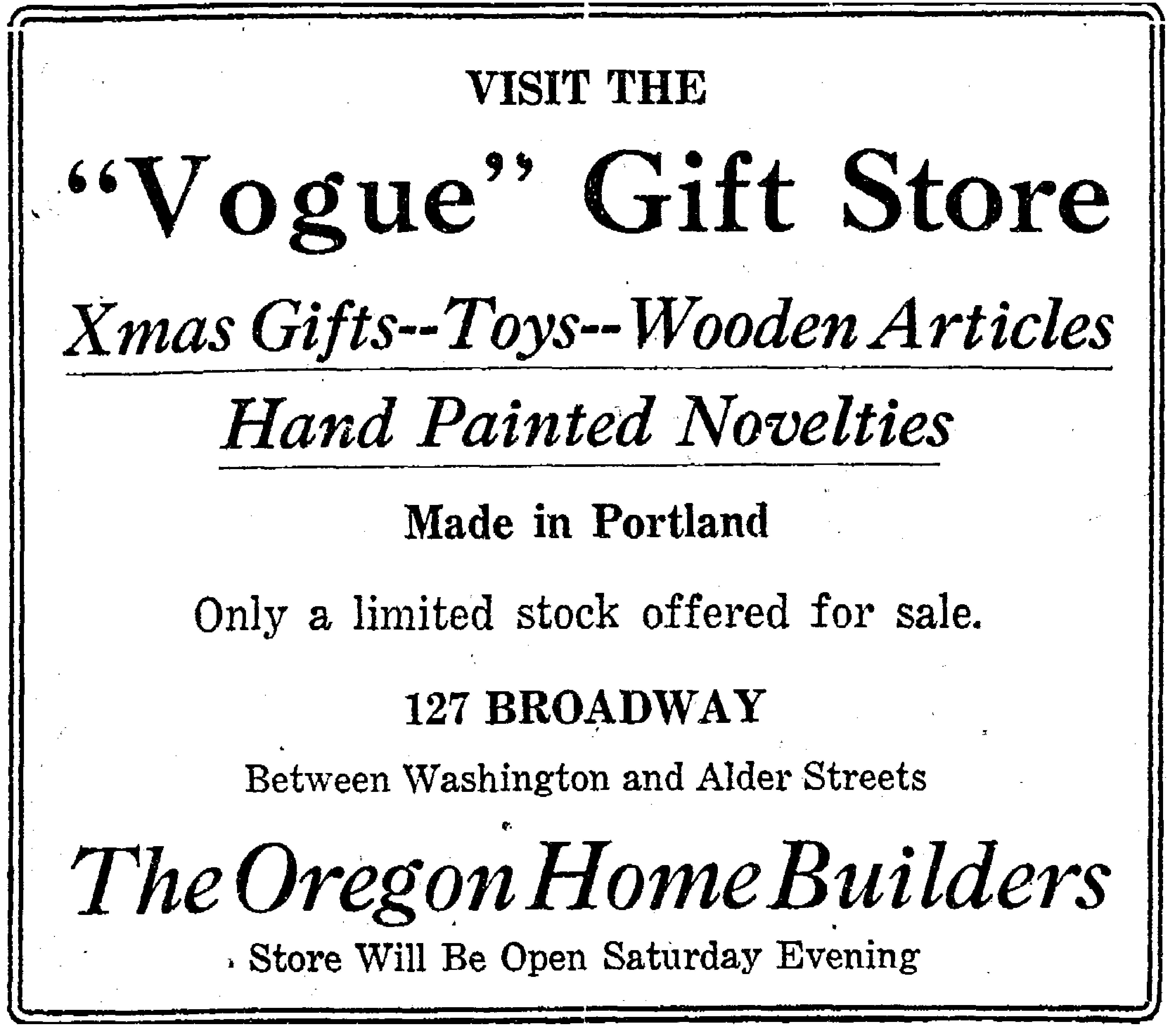
From The Oregonian, December 15, 1916


Despite the success and notoriety of the two mega houses on the Alameda ridge, Jeffery’s prominence and the company’s visibility in Portland life, by 1917 Portland’s economy and real estate market was beginning to slump and Jeffery’s path had begun to change.

Early 1917 saw an increase in the number of stockholders who were selling off large blocks of OHB shares by confidential blind box classified ads in The Oregonian. The county’s annual tax delinquency list published in February identified 15 OHB properties owing taxes dating back to 1915. And OHB’s “for sale” classified ads shifted away from homes and city property to agricultural acreage in the Willamette Valley and Montana. Something was clearly going on. And then this in a May 2, 1917 advertisement, as if to staunch any whispers:

“Guaranteed. That is what we offer you and stand back of with our reputation. We are here to stay—you can always find us. The Oregon Home Builders, established since 1911.”

In August, the company bought a brand-new Ford (listed in the new car purchase list in the newspaper…yes there was such a thing when cars were a new and uncommon thing). And then people began to leave. Salesmen first and then Alfred R. Johnson the general manager in early October. By then, the only name still associated with OHB was Earl H. Fry who specialized in agricultural land sales.

By late October 1917, the company dropped quietly into bankruptcy, taken over by a creditors’ committee. Jeffery’s name no longer appeared on OHB materials. No newspaper even mentioned the bankruptcy until four years later, though ads touting OHB farm properties appeared status quo in the newspapers until late 1917. The creditors’ committee was quietly maneuvering to sell off assets while it could in the months after bankruptcy.

By 1918, having financed the company’s operations but not received their promised profits, most stockholders were left with worthless certificates. Vacant lots that never sold had been fully mortgaged by OHB leadership and were accumulating back taxes. It wasn’t a pretty picture. Here’s the only printed explanation we’ve ever found about what happened, in the form of a letter to the editor from a disappointed stockholder and a response in January 1921:


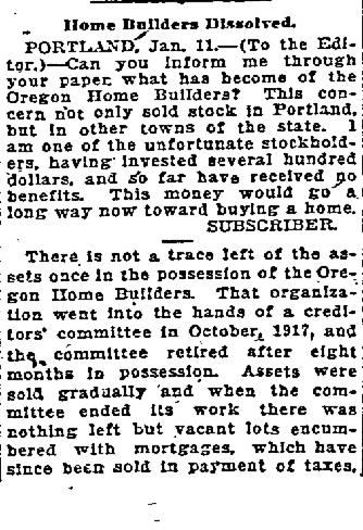
From The Oregonian, January 21, 1921

So what happened to Oliver K. Jeffery?

In January 1918, the Jefferys sold the flagship Alameda Park home to the president of Inman-Poulsen Lumber Company. Then in early March 1918, in a spectacular public announcement covered prominently by the newspapers, Jeffery sued his wife for divorce, and her alleged lover for $100,000 for “alienation of affection.” One week later, with no discernable change in circumstances, he withdrew both suits, but not long after, the couple split. In October 1918, Jeffery enrolled as a corporal in the WWI tank corps and went to training, but was never assigned to duty nor sent out of the Portland area. His interest had fully shifted to flying his personal airplanes and thinking about airplane-related business ventures.

Oliver K. Jeffery, from Who’s Who in Oregon, 1911


In 1919 Jeffery traveled for several months in Mexico, the reason given in his passport application to “investigate Mexican lands.” Returning to Portland in the spring, he published a piece in The Oregonian entitled “Mexico, vast horn of plenty, with undeveloped resources needed in U.S.”

Later that year Jeffery formed the Pacific Aviation Company with the notion of running scheduled airline service, backed by powerful Portland business interests. When that didn’t pan out, he formed the Oregon, Washington, Idaho Aircraft Company to do the same, traveling to Bend and to La Grande to meet with local officials and investors about establishing a possible company headquarters. By 1920 he had moved on to form his own distributorship in Portland, “O.K. Jeffery Airplanes,” which sold several Avro and Curtis airplanes. Later that year Jeffery moved to Los Angeles, where he was listed for several years in city directories as “aviation manufacturer.”

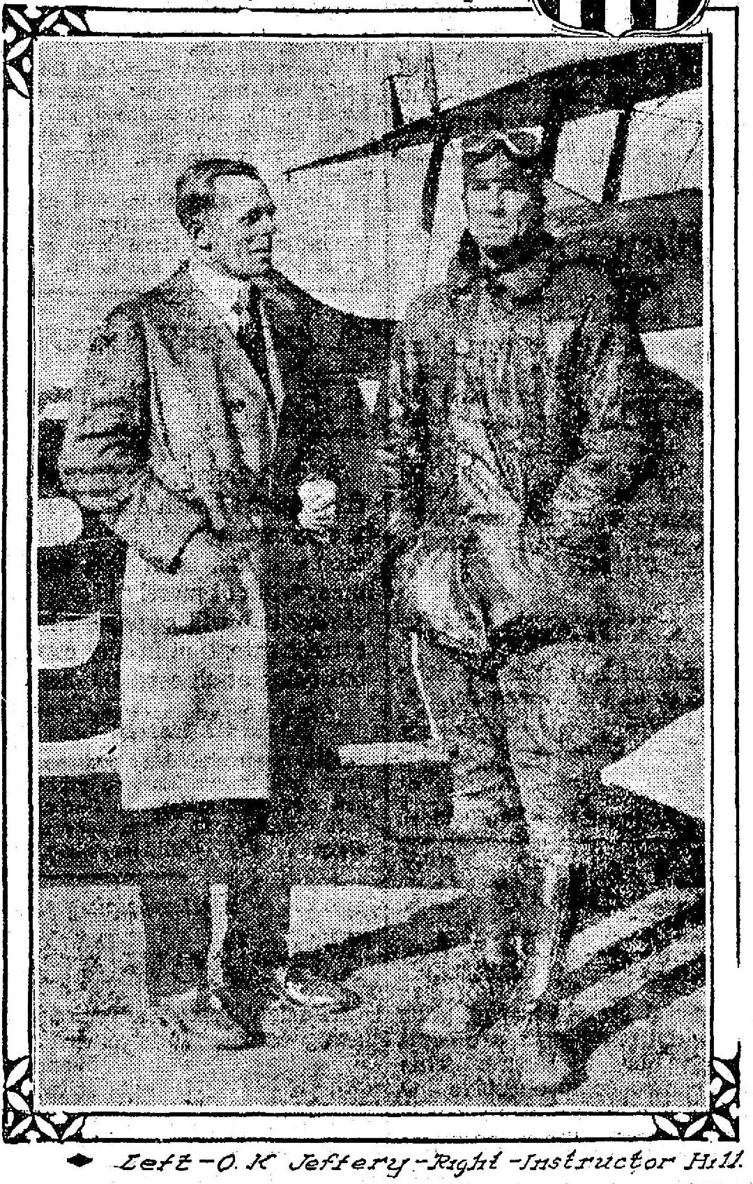
From The Oregonian, October 28 1917. OHB was in receivership when this was taken. The story that accompanied the photo quoted Jeffery at length about his flying adventures and reported that he was visiting “various flying camps in the east” and was organizing a company to manufacture parts for airplanes. Nothing said about the company that just had crash landed taking investors funds along for the ride.


Jeffery eventually found his way back to Portland. In 1924 he was the general manager of a company that existed only on paper called Blue J which attempted to bribe Portland City Commissioner Charles P. Keyser with Blue J company stock in exchange for control of a series of automobile campsites the company hoped to build around the city. Keyser was exonerated. Jeffery and his fellow Blue J board members were publicly admonished by City Council for their carelessness and their intent to influence public decisions.

Two years later he entered the mortgage business, opening a company called First Bond and Mortgage, which did not survive the Great Depression. By then—after the divorce and another brief marriage that ended in divorce—he moved in with his mother Nautilla in a big house in Northwest Portland where he lived for more than a dozen years—referred to as a “capitalist” in business directories—until his death at age 46 in December 1936.


What remains more than 100 years later is a paper trail of news stories, advertisements and court cases that combine to tell the story of an ambitious but flawed and failed business venture. In an interesting post script, Jeffery’s California mentor Charles Elder was convicted of fraud and sentenced to 13 months in the federal McNeil Island Penitentiary.

Out on the ground in Portland’s neighborhoods where life goes on, the houses built by Oregon Home Builders—embodying the work of nameless crafts people—have continued to speak for themselves by being lived in and loved by their Portland families.


Listing of houses built by Oregon Home Builders

This list has been gleaned from a careful review of newspapers between 1912-1921 and from a study of building permits in the Alameda Park plat. In most cases, OHB classified ads did not provide specific addresses or even general vicinities. Any specific address listed here has been verified as an OHB-built home. We’re certain there are a number of OHB homes not on this list and we’ll do our best to keep it up to date as we find more. Our best guess is that during the arc of OHB’s existence, they may have built between 125 and 150 total homes.


1912 (~2)

Alberta Street (the listing did not provide an address)

4221 NE Glisan


1913 (~17)

Eight houses near NE 39th and Sandy, all believed demolished

3141 NE Multnomah

3211 NE Multnomah

3200 Block NE Multnomah (two homes, both demolished, built concurrent with 3211 & 3141; Jeffery lived briefly in 3211)

Near Jefferson High School (no address given)

Four cottages in Gearhart, Oregon (no address given)


1914 (~32)

Two houses at SE 28th and Tibbetts (not found)

Four houses at NE 23rd and Wasco (not found)

NE 33rd and Wasco (not found)

Five houses in Carlton, Oregon

Several houses in Astoria, Oregon

Purchased 18 lots in Irvington, no addresses given

2803 NE 24th

4323 NE 26th

4807 NE 29th

8719 SE Alder

1734 NE Broadway

836 N. Buffalo

3123 NE Dunckley

3135 NE Dunckley

3229 NE Dunckley

3259 NE Dunckley

2233 NE Mason

A house on SE Stark in the Altamead plat (not found)

916 N. Stafford

8730 SE Washington (postcard house)

8836 SE Washington

2314 NE Wygant

*In 1914, the company reported it had built 52 houses.


1915 (~20)

1216 NE Alberta

3024 NE Bryce (photo)

3033 NE Bryce

3128 NE Bryce

3140 NE Bryce

2931 NE Dunckley (Walkup/Thomas – photo 911)

3005 NE Dunckley (Lemkuhl – photo 931)

3115 NE Dunckley

3215 NE Dunckley

8637 SE Morrison

3104 NE Regents

2523 Skidmore

2607 NE Skidmore

2613 NE Skidmore

2824 SE Yamhill

3407 SE 20th

SE 22nd and Hawthorne (two houses, not found)

4142 SE 25th

3535 NE 25th

3930 NE 29th


1916 (~15)

2903 NE Alameda (Thomas Prince house)

5927 NE Alameda (postcard house)

5935 NE Alameda

2915 NE Dunckley

5534 NE Hoyt

435 NE Laurelhurst Place

1923 SE Pine

2023 SE Pine

2043 SE Pine (demolished)

4706 NE Sandy (demolished)

2003 NE Stanton

2017 NE Stanton

8004 N. Van Houten

1632 N. Webster

225 SE 20th

235 SE 20th (postcard house)

3636 SE 21st

1816 SE 24th

3426 NE 21st

1726 NE 24th (photo – built for Prince)

3912 NE 32nd Place

1522 NE 49th

1534 NE 49th


1917 (~24)

2930 NE Bryce

3006 NE Bryce

3276 NE Bryce

3284 NE Bryce

3296 NE Bryce

5605 N. Detroit

2717 NE Mason

2807 NE Mason

54 NE Meikle Place

2409 SE Stephens

6822 SW Virginia

6834 SW Virginia

4815 NE 11th

3434 NE 17th

3444 NE 17th

3436 NE 21st

3446 NE 21st

1738 SE 24

1804 SE 24th

1816 SE 24th (photo and story)

1816 SE 24th

1826 SE 24th

5937 NE 30th

2112 NE 51st

SE 21st and Hawthorne (19-unit two-story apartment planned but never built)

In praise of alleys

Here’s something you probably have not spent much time thinking about: Northeast Portland alleys.

It’s OK that you haven’t been thinking about them—it’s hard to know exactly where they are, some neighborhoods have them and some don’t. And even where they do exist, they might be hidden behind a wall of blackberry bushes, or garbage cans, or yard debris.

But now it’s time to think about alleys and to go out of your way a bit to appreciate and understand their history, demise and possibility. Along the way, we should also examine the question of why one neighborhood has them and another doesn’t. Mull that over a bit while we explore this topic.

First, an important fact about Portland alleys: virtually all of them are on the eastside.

Downtown Portland, known for its small and walkable 200’ x 200’ blocks, has never had alleys, to the chagrin over time of some business owners and public works officials who have complained that our downtown grid makes deliveries and trash removal too complicated and public. If our city blocks had alleys, they’ve argued, those essential but less desirable functions could take place out of view, giving the front of the business more leeway and prominence.

Here’s a great map that shows the extent and location of Portland’s alleys. Have a good look at it then come back here and we’ll continue our exploration.

There is at least one common denominator in this map’s seemingly random purple grid segments: they exist in neighborhoods platted before 1909. In Portland, as in so many other US cities, alleys were a utilitarian feature designed before the age of automobiles. The barn out back that might have housed a horse or wagon also contained garbage and other chaos that you didn’t want to have out front. But when the car came along—a symbol of convenience, independence and even status—garages began their migration from out back to the front of the house.

After about 1910, land development companies platting Portland’s eastside neighborhoods responded to this shift by dropping alleys and back garages from their plans. Not incidentally, this allowed houses to be a bit larger and to shift back farther from the street allowing for front yards and landscaping, as well as driveways and garages.

Alameda and its neighborhoods immediately to the north are a perfect illustration. Vernon, Elberta (not a typo) and Lester Park—the subdivisions just to the north across Prescott—were platted between 1903 and 1908 and they have alleys and 40′ x 100′ lots. Here in Alameda, platted in 1909 and built starting in 1910, there are no alleys, but 50′ x 100′ lots. North of Prescott, smaller houses crowd the street and yards are small. South of Prescott in Alameda, houses are larger and set back farther. No alleys. (Check out our Maps page and scroll down to find the original plats for Vernon, Elberta, Lester Park and Alameda Park.)

Yes, there are other contributing factors at play: Alameda has the ridge, which breaks the rectangular grid pattern. Plus, Edward Zest Ferguson and his Alameda Land Company wanted Alameda to be an upscale addition of larger homes, as opposed to the more compact homes and lots in subdivisions to the north. Irvington, for instance, platted even earlier than all of us above the ridge, does not have alleys. This was a function of the size and siting of much larger and costly homes on relatively constrained lot sizes. It’s hard to have both large homes and alleys given our compact grid.

The presence or absence of alleys was central to the question of site and building design, real estate value, and marketing potential at the turn of the last century. Throw in the advent of automobiles and you’ve crossed a tipping point away from alleys in the minds of early property developers. Why bother with alleys anymore?

So, there’s our answer to why some eastside neighborhoods have them and some don’t: it’s largely related to timing (pre- and post-1909 as the key date), with the advent of the car looming large, and a few other considerations like targeted market sector and house size. Bottom line is that after 1909, no more new alleys were built on Portland’s eastside.

Here in Northeast Portland you’ll find two types of alleys: the obvious ones that are a long straight laneway right up the middle of the block adjacent to back yards and paralleling the length of the fronted street (typically the numbered street). You’ll find these between Prescott and Alberta, from 24th to 33rd. Another form you’ll find is the tee alley, on either side of Ainsworth between NE 23rd and NE 33rd. This form provides a shorter cross alley (like the top of a letter T) that bisects the long laneway. These are interesting to explore and are in pretty good shape.

Once you start walking our alleys, you begin to see clues to the past and to future potential, and you can see how different neighborhoods have responded to their alleys. While we haven’t walked every Portland alley, we’ve explored a lot of them, and offer these observations as an enticement.

This alley is just off Alberta between NE 29th and NE 30th. Looking a bit like a gallery, the pools of light here illuminate boards that advertise the adjacent T.C. O’Leary’s Irish Pub. It’s an enticing sight.

___

Most of the alleys between Prescott and Alberta from NE 24th to NE 33rd look something like this one: muddy ruts, grass, brush ready to grow over.

___

Here’s one just north of Alberta between NE 27th and NE 28th. The entrance is crowded with garbage cans and recycling bins but adventure up a bit and you see a kind of graffiti gallery.

___

Here’s one that has grown over. Looks like that laurel bush has eaten the garage too.

___

The Piedmont neighborhood has great alleys that run south from Rosa Parks to Killingsworth between MLK and N. Commercial. Lots going on here: powerline corridor, pavement and some interesting ADUs.

___

We came across quite a few alleys that had an entry threshold like this one with the gridded pattern scored into the sidewalk. This signaled the alley opening to passing pedestrians.

___

Some alleys like this one in Portsmouth have become debris dumping zones for neighbors, with piles of clippings, dirt and other debris forming impassable mounds. No more cars up this alley.

___

This Portsmouth alley is so well used and traffic-friendly that residents have built a driveway off the alley that seems like a primary entrance to their house. No need for a front yard here.

In recent years, there has been a resurgence of interest in alleys as public spaces that connect neighbors and neighborhoods. In many ways they are a hidden resource, public spaces in out of the way places. A few years back a consortium of city planners and urban design professionals launched the Portland Alley Project, which led to several alley maintenance and recovery projects. Here’s another great blog by San Francisco urban designer David Winslow with passages from his book Living Alleys: A new view of small streets.

Check these out, look at the map and then go for a walk. Get out there into this ready-made local trail system where you can slow things down and experience a completely different neighborhood than the one you think you know.

A Concordia alley

Northeast Portland’s Foxchase: What’s in a name?

If we asked you to find Foxchase on a map, could you?

Here’s a clue: it was one of a dozen different subdivisions created more than 100 years ago that taken together today make up what we think of today as northeast Portland’s Concordia neighborhood.

Here’s a visual clue: then-and-now photos of the same place, separated by 63 years.

Then: Looking east on NE Killingsworth at 30th Avenue, 1954. Note stop signs faced traffic on Killingsworth. The building with the striped awning is today’s Cup and Saucer Cafe. Photo courtesy of City of Portland Archives, reference A2005-001.365.

Now: NE Killingsworth and 30th Avenue looking east, March 2017. Lots of change in this photo: the Shell station on the northeast corner (which we knew for years as a U-Haul rental place) has been replaced by a type of massive apartment block that has become ubiquitous on Portland’s eastside.

Here is the other then-and now pair:

Then: Looking west on NE Killingsworth at 30th Avenue, 1954. How about that stop sign? By the time this photo was taken, the Alberta Streetcar that traveled down NE 30th Avenue to Ainsworth had been gone six years, but the “through street” mentality was still more with 30th than with Killingsworth. Photo courtesy of City of Portland Archives, reference A2005-001.366.

Now: NE Killingsworth and 30th Avenue looking west, March 2017

An unscientific survey taken on a Friday morning walk with the dog turned up the fact that most local business owners at the increasingly busy intersection of NE 30th Avenue and Killingsworth know they are in Foxchase. There are some Airbnb’s in the area identifying themselves as being in “Fox Chase.” And maybe a few residents who think of themselves as Foxchasers too. But chances are if you tell a friend “I’ll meet you in Foxchase for a beer,” they’re going to need directions.

So when we came across the 1954 photos recently and were already doing some serious digging into how the Foxchase plat came to be—and it is a fascinating story—we thought it was time to set the record straight with a little history.

First of all, it’s Foxchase. That’s what the plat says, filed on April 1, 1889 by Eugenie M. and J. Carroll McCaffrey. Here it is:

Foxchase Detail 1889

Only the numbered streets retain their identity today. McCaffrey = Alberta. Junker = Sumner. Alvan = Emerson. Birch = Killingsworth. The intersection of NE 30th and Killingsworth anchors the northwest corner.

The 1889 Foxchase plat was actually filed in the town of East Portland. At that point we were a separate city distinct from Portland, as was Albina and several other outlying communities. In 1891—in an attempt to roll together the greater Portland area population into one number that would keep us ahead of Seattle—the three towns consolidated to became one (46,385 people in Portland + 10,000 people in East Portland + 5,000 people in Albina = 61,385 people total in the Portland “metropolitan” area). Take that, Seattle (total 1890 population: 42,837).

Not long after platting the property, J. Carroll McCaffrey started running classified ads in The Oregonian and the land speculation boom was on.

From The Oregonian, February 19, 1890. McCaffrey set up the Western Oregon Land and Investment Company for his real estate deals.

Dozens of Foxchase real estate transactions show up in the early 1890s. All speculation: the buying and selling of lots.

At that point in our history, there wasn’t much up here on these gentle slopes of the Columbia Slough and the Columbia River beyond. Fields, forests, a few dairies here and there; Homestead Act claims from the 1860s held by a couple dozen families. Alberta was a dirt track meandering 10 blocks between MLK (Union Avenue then) and what is today’s NE 15th Avenue. Across the Willamette River, the small grid of what we think of as downtown Portland was getting ready to explode, and investors like McCaffrey knew it. His business was to use other people’s money to buy up open land for the eventual grids of streets and lots that would follow.

Here’s where the story gets interesting.

J. Carroll McCaffrey was a Georgetown-educated attorney, born and raised in Philadelphia, who kept a small practice there as well as here in Portland. He and his wife Eugenie were busy on the social scene of both communities and frequent travelers back and forth.

They showed up in Portland about 1886 and McCaffrey quickly became ingratiated with Portland business leaders as a likeable and cheerful person. That fall and through the winter of 1887, J.C. placed the same advertisement in The Oregonian almost every single day:

McCaffrey found what he was looking for and was quickly engaged in the development of Portland Heights (southwest Portland), being quoted in the newspaper about the availability and quality of artesian well water in the southwest hills, helping incorporate the Portland Cable Railway Co. to transport people up to the heights, and building a prominent mansion known today as the Markle House to entice development.

At the same time as he was speculating on property in the southwest hills, McCaffrey looked to the east side guessing Portland was headed that direction too. He acquired a majority interest in a 15-square block portion of what was the larger 160-acre Donation Land Claim of George Emerson. He and Eugenie platted these 15 blocks as Foxchase.

Here’s where the Philadelphia connection comes in. Fox Chase is the name of a comfortable neighborhood in northeast Philadelphia, named for an 18th century inn. During McCaffrey’s timeframe of reference—the 1870s-1880s—Philadelphia’s rich and famous were building their mansions in Fox Chase. He and Eugenie were trying to call that to mind.

Their choice of street names hit close to home too: Because Alberta didn’t exist except in the Albina area, they planned for that main street on the south end of the plat to be McCaffrey Street. Junker, the next street to the north, was Eugenie’s maiden name. Was Alvan the nick name for one of their four young children? And Birch? Hmm, no birch in that area. Choose any nice tree name.

McCaffrey liked what he saw in the land speculation business, and in 1890 incorporated as the Western Oregon Land and Investment Company (that’s his company in the 1890 classified ad up above). He was just getting rolling.

But not long after that, things started to fall apart. McCaffrey unsuccessfully sued his former partners in the southwest Portland cable railway enterprise and George Markle, who bought the mansion McCaffrey had built on Portland Heights. In 1892 McCaffrey was arrested for land fraud related to 80 acres he was trying to sell south of Oregon City, charges he wriggled out of on a technicality. In 1893 he was charged with embezzlement, which he tried to shrug off as a misunderstanding and escaped because of technicality related to evidence. That same year he was accused of fraud by two of his fellow members of the Chamber of Commerce. And, Eugenie was granted a divorce citing inhuman treatment.

When he was indicted on check fraud in February 1894, The Oregonian reported that in a period of a few years, McCaffrey had been remanded to a grand jury on a dozen fraud charges of various types. He was no longer able to secure a bondsman to keep him out of trouble, and business must have gotten tight as people discovered he was not a man of his word. Eventually, McCaffrey was convicted of check fraud and served a few months in the Oregon pen before winning on appeal on a technicality, when he fled to his native Philadelphia to resume his legal practice.

Here’s where it gets stranger than fiction (a small reward for those of you who have stayed with me this far): In 1895, McCaffrey was hired by the defense team of serial murderer H.H. Holmes (made famous in the book The Devil in the White City…about the “murder castle” near the 1893 Chicago World Fair) to try to persuade Pennsylvania Governor Robert Pattison and the Pardon Board to stay Holmes’s execution. We know McCaffrey was a persuasive attorney when it came to appeals, but not this time. Several months later, McCaffrey took his own life.

So, it’s probably OK McCaffrey Street never made it to the map. And interesting that Foxchase is making a comeback, though some still think of it as the northern part of Concordia.

We’ve written here before about the distinction between subdivision or plat names and neighborhood names. Most plat names have disappeared into the fog of the past, no longer used or even known by neighbors who occupy them every day. Plat names were provided by developers when they extended their portions of the grid into the fields and forests that were here before us. Just like the McCaffreys did, developers tended to choose plat names that sounded attractive or that called to mind the suggestion or essence of a special place.

Some of our favorites that exist invisibly under our feet here in northeast Portland today are Manitou, Railroad Heights, Spring Valley Addition, Town of Wayne, Durant’s Nightmare (yes, that’s a real plat name…referring to the nightmare the surveyor had in getting all the survey lines to meet up).

Long live Foxchase.

Alberta Park Marks 100th Anniversary

Alberta Park marks its 100th year in 2017, originally leased from a local property owner and then condemned by the city in 1921 to provide needed park and open space for the growing neighborhood.

Alberta Park 1929. Courtesy City of Portland Archives.

Like many areas of our city, northeast Portland’s neighborhoods evolved from Homestead Act land claims, where settlers bought or received rights from the federal government to develop open land for farms and homes. The recorded real estate transaction history of the Alberta Park area begins in 1866 when Mexican-American War veteran Harry McEntire used his Military Bounty land exchange certificate to acquire the property bounded by today’s Ainsworth, Killingsworth, 19th Avenue and 22nd Avenue: what we know today as Alberta Park.

As developers began to lay out streets and neighborhoods for the area beginning in the early 1880s, the property changed hands. Chinese business leader, landowner and entrepreneur Moy Back Hin, referred to by The Oregonian at the time as “Portland’s first millionaire” acquired the property, along with other real estate he owned downtown and on the eastside. Hin was frequently in the news for his real estate dealings and as a leader of Portland’s vibrant Chinese community: he served as Chinese Consulate General to Portland.

In 1910, Hin called on the city to follow through with plans to open Killingsworth Avenue between Union Avenue and NE 42nd (a $150,000 project for which the funds had not yet been identified) saying that as soon as the street was opened he would begin to build houses on his land.

During those years, eastside home construction was exploding: commercial development booming along Alberta Street; a vibrant home building business across nearby neighborhoods; a major streetcar line—packed with commuters—serving these new communities carved out of the fields and forests northeast of downtown.

Through its community clubs (of which there were many), locals began calling for development of parks. Influential Catholic priest The Reverend James H. Black—who went on to lead southeast Portland’s St. Francis Parish for many years–appeared before the Portland Parks Board to encourage the board to purchase land for a park in the Alberta area before real estate values jumped.

Minutes of the meeting show the chairman informed Father Black that “at present there are no funds on hand to purchase park property, and suggested that he write a communication to the Board incorporating his ideas in regard to the proposed Alberta Street Park property.”

In November 1912, locals petitioned the city, saying the more than 14,000 new residents of the area deserved a safe place to recreate and noting that nearly all the available lots for playground space had already been built over.

From The Oregonian, November 3, 1912

By 1917, the last remaining unplatted stretch of land in the area was the 17 acres bounded by 19th, 22nd, Killingsworth and Ainsworth, owned by Moy Back Hin. While Hin did eventually planned to develop the area for homes, he agreed to lease the property to the city starting in 1917 to serve as a park. Almost immediately, baseball diamonds, a clubhouse, walking paths and restrooms were built on the leased property.

In 1920, with the parcel in popular public use (and Killingsworth Avenue now open and paved between Union and NE 42nd), Hin offered to sell it to the city for $65,000, which was refused. The city responded with an offer to buy it for $39,333, which Hin refused. City Council responded on March 23, 1921 with an ordinance condemning the property and ordering it taken over by the city. After a jury trial, Hin was paid $32,000 and the property was taken over as a “public necessity.”

In 1924, the city passed an ordinance naming the parcel Alberta Park, though it was frequently referred to as Vernon Park as well. Hundreds of newspaper references to the park—and to the robust City League baseball schedule that occupied the new baseball diamond and sometimes drew more than 1,000 spectators—randomly used both names. Use of the Vernon Park name faded by the 1940s.

Investment immediately followed the city acquisition. A 1927 inventory of the property identified the following improvements:

1 wooden field house, built 1922 for $500 (heaters to be installed in 1927)

Two comfort stations (including a tool room) built in 1926 for $5,000

Sewer and water connections

One shelter

1925 plantings: $1,096

1926 plantings: $223.47

27 lights, cost $3,469.21

70 hose bibs and four automatic sprinklers

One large baseball field with backstop

One small baseball field with backstop

One wading pool, built in 1927 for $719

4 sets of horseshoe courts with steel frames and covers

2 sand courts ($100 and $108.72)

1 handball court

2 tennis courts ($1,722.58 and $2,055.86)

1 flag pole

Alberta Park “comfort station” and lamps date to 1926.

Hundreds of references in newspapers of the day called the new parcel as Vernon Park and sometimes used the two names interchangeably in the same story, but on April 9, 1924 the city passed an ordinance officially naming it Alberta Park. The official name change didn’t seem to stick: newspaper references to Vernon Park show up well into the 1940s.

An annual summer community picnic tradition connected neighbors of all ages and included a parade, games, the naming of a local queen, dancing and a lantern parade after dark.

From The Oregonian, August 16, 1924.

In October 1927, the Portland School District tried to acquire the southern five acres of the park as a location for the “new” Vernon School being planned to replace the original Vernon School south of Alberta Street that had become too small for the growing neighborhood. The city attorney, referencing the 1921 condemnation order and its intent that the property was acquired specifically for a park, refused to budge, protecting the park we know today. The school district scurried to find a site, selecting the current school location on the south side of Killingsworth Avenue across from the park.

In the 1950s, despite a fractious encounter with the neighborhood that included references to the 1927 decision by the city attorney not to subdivide the park, the city made a different decision and did allow use of the southwest corner of the park for construction of Fire Station 14.

Aside from the new fire station, not much changed in Alberta Park until the 1970s, when a comprehensive planning effort and citizen survey recognized a changing pattern of use. The 1972 report found:

“Alberta Park has remained relatively unchanged from its original development in the 1920’s. However, the interests of the users of Alberta Park have changed extremely. At this time we find Alberta Park as a park with high usage by children, while maintaining a passive character of walking and picnicking.”

In the 1920s and 1930s, the park was a kind of every-person’s backyard, where the community went in family units to picnic, play, celebrate, appreciate the plantings. By the 1970s, the car was much more a fixture of family life. Plus, the demographics of the neighborhood were changing and spending leisure time in a park as a family unit was no longer a high priority. The park was for young people.

As part of the 1972 master planning effort, 1,800 surveys were mailed to homes in a radius of six blocks from the park. The 182 replies that were returned ranked park needs, and 44 percent of the respondents raised concerns about park safety.

Drawing on the survey results, the 1972 Alberta Park Master Plan called for a new set of priorities, including adding a covered and lighted basketball shelter ($73,000); installation of tot play equipment ($2,000); paving of the existing gravel paths ($3,000); and resurfacing of the tennis courts ($2,000). These improvements were carried out over the following years as funds were available.

The park continues to be a community fixture: the sounds of pick-up basketball games can be heard on weekends and evenings; the upgraded playground structures filled with youngsters; and come spring the timeless sounds of baseball.

The Countdown Begins at Skidmore and 30th

The Alameda neighborhood received notice last week from developer Green Canopy alerting us that demolition of the 95-year-old home at NE 30th and Skidmore will begin on Tuesday, August 30th, and will probably take five days. Click here for background on what’s coming and the context behind this demolition. And here’s a link to an earlier post we wrote that includes a photo of the house from 1921, the year it was built by the Wickman Building Company for the George Kettleberg family.

FullSizeRender (11)

2933 NE Skidmore

We know the date with the wrecking ball is coming, so we dropped by in the early morning light to have a last look around, seeking clues to the generations of families and neighbors who have know this place. Here are some photos that document what we found. If you are inclined to send us a photo or two, or your own recollections of the house, we’ll post them here. Might be a nice way to capture some stories and perspectives.

Stairs facing NE 30th, 2933 NE Skidmore

Stairs from the back door facing NE 30th Avenue.

Looking west, 2933 NE Skidmore

East side of the house from NE 30th.


Living room, dining room and reflection, 2933 NE Skidmore

Through the livingroom window (and a reflection) toward the dining room and kitchen.


Chimney and vinyl siding, 2933 NE Skidmore

Chimney on the east side of the house.


Mailbox, 2933 NE Skidmore

Front porch mail slot, boxed out by siding material.


From kitchen looking to front, 2933 NE Skidmore

Looking through the back porch, the kitchen, the dining room and the living room (basement stairs on the right). The demo crew has already removed the asbestos flooring from the kitchen.


Back door and enclosed porch, 2933 NE Skidmore

Back door and enclosed porch. Note the close proximity to the house just to the west.


Back porch, 2933 NE Skidmore

Back door, basement door.

Garden hose valve, 2933 NE Skidmore

Garden hose valve.


Original numbers, 2933 NE Skidmore

Original address tiles from the post 1930s address change. The original address was 915 Skidmore Street.

Filling the eastside gulches: “The last stand of the frontier in Portland”

Yes, we’re diverging a bit from old houses, but our recent foray into Portland’s lower northeast side has been interesting, plus at least a couple of our readers asked a good question: so when did that happen?

We know from our recent look at the 1909 Sanborn maps that the western edge of Portland’s eastside represented a major challenge to turn-of-the-last-century developers and engineers. Everywhere the land met the waters of the Willamette and its tributaries–and in the upslope transition to the relative plateau we consider today’s eastside–the land was marked by gulches, gullies, ridgelines, swamps, seeps and seasonal creeks.

Sanborn maps from 1909 referred to these areas simply as “deep gulch” which was less a geographic place name than a kind of short-hand for you’re gonna have some work to do if you want to build here. Sanborn didn’t show topographic lines, locate waterways or note other natural features. Just white space implying terra incognita. Interesting that for a fire insurance map, they didn’t consider the fire hazard coming up out of the gulch: lots of summer news stories from those early days of gulches on fire and nearby homes being threatened.

So if you’re like us, you want to know a little more about the extent and location of these places. Click around in the Sanborns below to look at some of the deep gulches in Eliot and Lower Albina. You’ll recognize the street names: some of them still don’t go through today because of old fashioned topography, and of course there are two major sports arenas, a hospital and a major interstate highway that have reshaped the landscape too. Still, have a look to set the table for the story of development that follows and the memories of a little boy who grew up playing in the gulches. And if you’re interested in learning more about Portland’s “hidden hydrology,” take a look at this cool set of maps we came across while looking around.

img6

Here’s the area around today’s Portland Public Schools building off Dixon in Sanborn Plate 287 from Volume 3 in 1909. If you venture around this vicinity today as we did recently, you’ll see the line of bank hasn’t moved a whole lot, but the bottom of the gulch has clearly been filled. For a comprehensive discussion of the development of this area, check out Roy Roos’s excellent book The History of Albina.

img6

In Plate 297 above, you see a channel toward the bottom of the map at the “intersection” (we use this term loosely because these were little more than gravel traces, not engineered roads at the time) of Wheeler and Broadway, and an east-west hollow up toward the top all along Weidler, where Sanborn notes that either the street or future buildings, or both, were planned to be built on posts. Bring on the engineers!

Let’s hear from Edward W. Coles, who grew up on Hancock Street, one block from this terra incognita, at today’s 77 NE Hancock. Coles was an adventurous schoolboy at the turn of the last century. His explorations and memories are collected in a self-published volume called These Were My Days. In just over 90 pages, he brings Portland day-to-day life of the 1900s into very clear focus. It’s great reading: a time capsule, really, that we’ll draw on again down the line. Here he introduces us to one of the most memorable afternoons of his entire life, which happened in Montgomery Gulch at the foot of Hancock Street.

One of my most unusual experiences happened when I was in my early teens. Ecology was not a concern in those days. They threw most anything down the hill into Montgomery Gulch. [My friend] Orlo and I would go down after school looking for anything we could use. Once, there was a piece of galvanized pipe 2 feet in diameter and 15 feet long which was lying on the side of the hill. He dared me to slide down the inside.

I put both arms against my sides and slid down. The only trouble was that the lower end had dug in the dirt and I couldn’t get out. I hollered and Orlo tried to move the pipe but it was too heavy. Then he got frightened and left, leaving me stuck in the pipe. I thought he was going for help. I wondered what would happen to me: maybe I would starve or maybe the rats would crawl into the pipe when they saw I was helpless. I screamed but my voice only echoed against the pipe. I was frantic, and I was sure that my days were numbered.

In the meantime, Orlo went to his home. Eventually my mother called me for dinner. No Edward. She had all the neighbors hunting, but no luck. Orlo had never said anything to anybody; he was too frightened. They called the police, but no luck. Then, one lady said that she saw me with Orlo early in the afternoon and that Orlo must know something. Finally the policeman frightened Orlo so badly that he confessed where I was. By that time it was getting dusk, and four or five men went down to the Gulch and pulled me out. I had been in the pipe for over two hours; I was almost out of my mind. I never thought I would get out of there alive. I was in bed for two days and had nightmares for months.

About that time they decided to put Montgomery Gulch to some good use, for valuable industrial property. They used hydraulic mining equipment: a giant hose and nozzle and lots of water at high pressure. A drain was made to the Willamette River, but after several weeks they had dead carp. The odor was awful. However, they eventually got it all washed down and smooth, all near the railroad and the river.”

Montgomery Gulch was a geographic place–you can see it there in Sanborn 287–and it was perceived as a major impediment to development. Named for James B. Montgomery (1832-1900), a railroad and real estate business leader and Oregon legislator who was a force behind the development of Lower Albina. Here’s a story from The Oregonian on November 13, 1914 describing ongoing challenges with filling Montgomery Gulch (note the salute to young Coles and his playmates down in the third paragraph):

img6

While these rough places on the bluffs may have meant adventure (and a scary afternoon) for young Coles, real estate developers had bigger issues. For them, the transportation and infrastructure challenges meant property with less value, and obstacles for higher value properties they were trying to sell. Gulches elsewhere in Portland were being converted to sewers draining directly into the Willamette. Some were open garbage dumps. Others were bridged by long trestles for roadways or rails. Whatever the strategy, a growing Portland needed more flat land and was ready to do whatever it took to solve the gulch problem. Here’s a quote from The Oregonian on March 3, 1905 that summed up the sentiment of the day:

“Around Vancouver Avenue and Weidler and Victoria streets is a deep gulch that runs down from Irvington. Into the gulch is dumped debris of all kinds. A row of buildings backing upon the gulch are said to be without proper sewerage. Complaints and remonstrances to the authorities have availed naught, say the neighbors.”

And a letter to the editor from November 6, 1912:

“Why could not all the refuse be dumped in some deep gulch and then have a crew of men grading on the mountain side closeby and dumping their earth on the garbage? Earth will purify any putrefaction it comes in contact with. Signed, O. Hempstead”

To the question of differential property values of gulch vs. non-gulch—and who pays the cost of improving infrastructure—some developers wanted to put the entire cost only on those owners whose sloped property was in need of improvement. Many on the eastside argued to spread the cost across all owners who would benefit.

Ultimately, as Portland’s population grew and property values increased, the city figured out how to contract the substantial grading and fill work. Fill was brought in from elsewhere on the eastside, and the city undertook a major project of widening and lighting Northeast Broadway to coincide with opening of the Broadway Bridge on April 22, 1913. Here’s an article from June 30, 1912 about big changes to the gulches, the streetcar line, and to Broadway itself:

6-30-1912 Fills Planned

By the time the Broadway Bridge opened, most of the curbs and streets were in place up here in Alameda. Sewer lines were in and streetcar lines and local businesses were starting to bloom. The grid was in place, the gulches filled, and the first steps were taken on the uncertain path to the future.

NE 3rd and Broadway as you’ve never seen it

One of the great joys of our research is finding the unknown—more properly the long forgotten—in the midst of the known. Photos, memories, documents and stories from the past add new understanding to places we know (or think we know), and often bring a hint of the familiar: the profile of the ridgeline on the horizon, the curve of a street, the form of a building we recognize.

Sometimes these clues from the past are unreconcilable with the landscape we know today. In the world of Northeast Portland neighborhoods, pretty much anything after 1910 will carry a hint of the familiar. Turn back the clock a bit further and those hints are harder to detect.

Case in point: this Sanborn fire insurance underwriting map from 1909 of the Eliot neighborhood, showing the vicinity of the busy intersection at Grand and Broadway that we all know. Or think we know. Have a good look and pay attention to the location and extent of the gully shown as Deep Gulch, the wooden bridges, the buildings up on posts, the row of houses with their bay windows all to the side. Check out the State Laundry Company building too, and the note about the night watchman. (If you don’t know about Sanborn maps—which were used for fire insurance underwriting—be sure to check out our post on the topic).

1-16-16 Sanborn 289 Detail

Detail from plate 289, Sanborn Fire Insurance Map, 1909

Everything in this frame from 1909 is absolutely gone today—the gully, the buildings even the streets which have been widened—and most of us speed through here (being careful about the red-light cameras) on our way somewhere else. Below is a modern view of that intersection.

1-16-16 Detail from Google Earth

Thanks to Google Maps. Click the thumbnail above for the full photo.

* * *

Ready for an even closer look? This is the fun part where we get to try to imagine the landscape that once was, and how different it is today. As you study this photo, be sure to check out the detail: the awning style shutters; the orderly clapboard and fish-scale siding; the beautiful shingle roof; the decorative round gable end ornaments; the family members at each level; the gulch out back. The picket fence in the left foreground is running north-south along the edge of NE 3rd. The double gable end faces NE 3rd, so this view is looking off to the south/southwest at the corner of NE 3rd and Broadway.

1-16-16 Soden Home 3rd and Broadway

Home of B.T. and Cora Soden, NE 3rd and Broadway. Photo courtesy of Bob Elston.

And an approximate view today:

Site of Soden Home, NE 3rd and Broadway, northwest corner

237 NE Broadway in January 2016.

We’re able to feed this imagination thanks to fourth-generation Northeast Portland resident Bob Elston, great-grandson of Bartholomew and Cora Soden, who recently shared these and other family photos that got us to wondering about this part of the neighborhood, and to haunting these blocks ourselves in order to take a good look. Thanks Bob.

Fast forward a few years and a slightly different angle at the Soden place, this time looking west/northwest showing the barn out back, which is depicted in the 1905 Sanborn map. Note the same wooden bridge on Northeast 3rd over Deep Gulch, which keys the building into the northwest corner of that intersection. The dip of the gulch is still visible off to the left.

1-16-16 Soden Home 3rd and Broadway 1905

NE 3rd and Broadway, looking west in the late 1890s. Photo courtesy of Bob Elston.


Mildred, Willard, Frances, Raymond in front of the house on NE 3rd.

Frances, Willard, Mildred and Lester Soden, in front of the house on NE 3rd, 1898. This view is looking north on 3rd. Photo courtesy of Bob Elston.

* * *

Bart Soden was owner and proprietor of B.T. Soden Hay, Grain, Coal and Plaster, provisioner of vital goods for the eastside at the turn of the last century. His warehouse and business was located just a block east from the family home at the southeast corner of Union and Schuyler (today’s MLK and Schuyler). Scroll back up to the Sanborn map and look at it there in the upper right corner, labeled “Hay, Grain and Cement Ware HO.” Here’s a picture of Bart and a helper, probably from about 1905, showing the delivery wagon heading out on a run:

1-16-16 BT Soden Business

The southeast corner of NE 3rd and Union, about 1905. Photo courtesy of Bob Elston.

Here’s the same view today:

Site of Soden Business, MLK and Schulyer, southeast corner

Bart was born in Australia in 1849, came to Oregon as a young boy, and grew up in rural Polk County. He earned a degree from the Oregon Agricultural College in 1879, tried his hand at teaching for a while, and eventually moved to Portland in the 1880s where he married Cora Wells, 16 years his junior. The couple built the house and business we’ve been looking at here, raised a family of two sons and two daughters, and were active in Portland society. Bart died in 1926. Cora lived until 1950. Both parents and several of the children are buried in the family plot at Portland’s historic Lone Fir Cemetery.

We’ve recently come across a memoir by a Portlander who grew up a couple streets over about the same time as the young Sodens. Stay tuned for his observations, which will continue to help us bring this long lost landscape back to life.

Beaumont 1927 Construction Photo Series

Four more tantalizing views of the Beaumont corner at 42nd and Fremont from the late 1920s (we think June 1927), all showing some major trenching and dirt-moving activity out in front of the shops on the north side of the street. All four are from the collection of Beaumont Dry Goods shopkeeper Bessie Kramer and her grandson Paul Kirkland. If you need help orienting yourself, we’ve placed current companion views to each of these at the bottom of this post.

You’ll recall from our earlier posts that Bessie Kramer ran the Beaumont Dry Goods and Book Shelf store in the 1930s, which—based on Polk City Directory records—we believe started out life as Fremont Dry Goods in 1927 here on the north side of Fremont, about where today’s Americana Frame shop is now, and later moved with a name and ownership change to the south side, where Shop Adorn is today, when construction of that building was finished in the fall of 1928.

Incidentally, we’re mapping the comings and goings of Beaumont’s various businesses over the years, and doing some homework on the Beaumont Market/Gazelle commercial building on the south side of Fremont at 41st (which is actually two buildings built seven years apart) so stay tuned for that. If you have photos or insights to contribute on the general topic of Beaumont business over the years, we’d love to hear from you. In the meantime, have a good look at the images below which we believe were shot all about the same time (click on each one for a larger view), and when you’re done, come back here for some discussion.

Beaumont Construction 1

East view

Let’s start by orienting ourselves here. Look carefully at the address over the door of the shop to the left, which is Fremont Dry Goods, 1213 East Fremont Street North. You can’t quite see the business name in the upper left, but you’ll see it in the next photograph. It reads “Fremont Dry Goods.” After Portland’s Great Renumbering in 1931, that address became 4223 NE Fremont, today’s Americana Frame. Next door to the right, at today’s 4225 NE Fremont, is Fremont Pharmacy, home of ice cream, cigars, drugs and on this day lots of fireworks. The pharmacy business shown here, (which moved across the street in 1929 and became a neighborhood fixture in the shop occupied by today’s Gazelle) is known to us today as Silhouette, a tailoring shop. There are two more businesses out of frame to the left–Buy Rite Grocery and Beaumont Hardware–but we’ll get to those in a moment. Click here to keep reading…

The early Alberta area and its bungalow grocery

First of three parts: Understanding the neighborhood’s early beginnings

We’ve been working on a fascinating property in the Concordia neighborhood, formally known as Lester Park (that’s not a typo, that’s an actual plat name).

It’s a store and home built by Irish immigrants and operated for several generations, eventually running out of retail energy in the 1960s when it became a church and then an artist’s studio before nearly collapsing from years of deferred maintenance and decline. We’re eager to share the fascinating story of this sweet little building—which has been lovingly restored—and an incredible photograph from the pinnacle of its retail life.

But first, we have to provide some context about the area that today might like to be known more for its hipness than the complicated polarity of change underway through gentrification, though both are present.

To be clear, the geography of the area in mind actually holds several of today’s formally named neighborhood associations: Humboldt, King, Vernon and Concordia, and the business district known as Alberta (which technically resides mostly within the Concordia neighborhood: think MLK to NE 33rd and Alberta to Killingsworth). But back in 1909, this whole area was a muddy, brushy flat that existed outside city limits and beyond what Portlanders thought of as their city.

If you lived up here in 1909, you were probably either a dairyman or the advance guard of development, and you could see the city creeping your direction. After the Lewis and Clark Exposition, Portland was booming with new residents and new construction, and hungry for relatively close-in developable land.

Here’s a hopeful word picture from H.D. Wagnon, Alberta’s number one promoter, in January 1910 that picks up the story from the perspective of a man on horseback riding through brush thickets in the area that helps provide proper context for our bungalow grocery story.

Alberta District Thrives, 1-9-1910

From The Oregonian, January 9, 1910

 If you opened up the real estate section from any Sunday edition of The Oregonian during these early days you’d find a flurry of advertisements for these desirable lots. The new streetcar provided access, the lots were affordable compared to other new subdivisions elsewhere in town, money was relatively available to loan during the rising economy of 1910, and people were flocking to the area.

Of course, this caused its own problems, documented a few months later in the June 26, 1910 edition of The Oregonian:

Alberta District Grows, 6-26-1910

From The Oregonian, June 26, 1910

 And by the end of 1910, Alberta was becoming so populated, neighbors were calling on the city to build a school.

School demanded, 12-25-1910

From The Oregonian, December 25, 1910

 The problem of education infrastructure lagging behind neighborhood development was a trend across the eastside, which was successfully raised and driven by active and engaged parents (particularly moms). One might think this equation would be clear enough for neighborhood developers (homes + kids = need for schools), but their focus was on business and the sales of lots represented profit while the construction of school buildings represented only cost. Secretary Wagnon, a promoter through-and-through still preferred to focus on the immediate positives:

“One cannot get beyond the sound of the hammer or the sight of piles of lumber in this district.”

We like that sound-picture and can absolutely imagine what it must have been like on a weekday morning, closing your eyes anywhere along Alberta and hearing hammering and construction in every direction. That little details tells its own story.

Against this backdrop of growth and growing pains, local residents started some new traditions with unintentional echoes in the life of the district today. Market fairs for produce and hand-made products were springing up mostly as a matter of necessity for local residents.

Market Opens Today, 6-20-1914

From The Oregonian, June 20, 1914

The open-air markets were a temporary fixture, but steady retail was shoring up its presence in the district. That’s where our bungalow grocery story will begin: construction of a store connected to a house at the northwest corner of NE 27th and Going, right in the heart of the construction boom.

Next up: In Part 2, 105 years ago, an older Irish couple moves to the neighborhood and opens a men’s clothing shop, which quickly becomes a neighborhood grocery.

%d bloggers like this: