One of the great joys of our research is finding the unknown—more properly the long forgotten—in the midst of the known. Photos, memories, documents and stories from the past add new understanding to places we know (or think we know), and often bring a hint of the familiar: the profile of the ridgeline on the horizon, the curve of a street, the form of a building we recognize.
Sometimes these clues from the past are unreconcilable with the landscape we know today. In the world of Northeast Portland neighborhoods, pretty much anything after 1910 will carry a hint of the familiar. Turn back the clock a bit further and those hints are harder to detect.
Case in point: this Sanborn fire insurance underwriting map from 1909 of the Eliot neighborhood, showing the vicinity of the busy intersection at Grand and Broadway that we all know. Or think we know. Have a good look and pay attention to the location and extent of the gully shown as Deep Gulch, the wooden bridges, the buildings up on posts, the row of houses with their bay windows all to the side. Check out the State Laundry Company building too, and the note about the night watchman. (If you don’t know about Sanborn maps—which were used for fire insurance underwriting—be sure to check out our post on the topic).
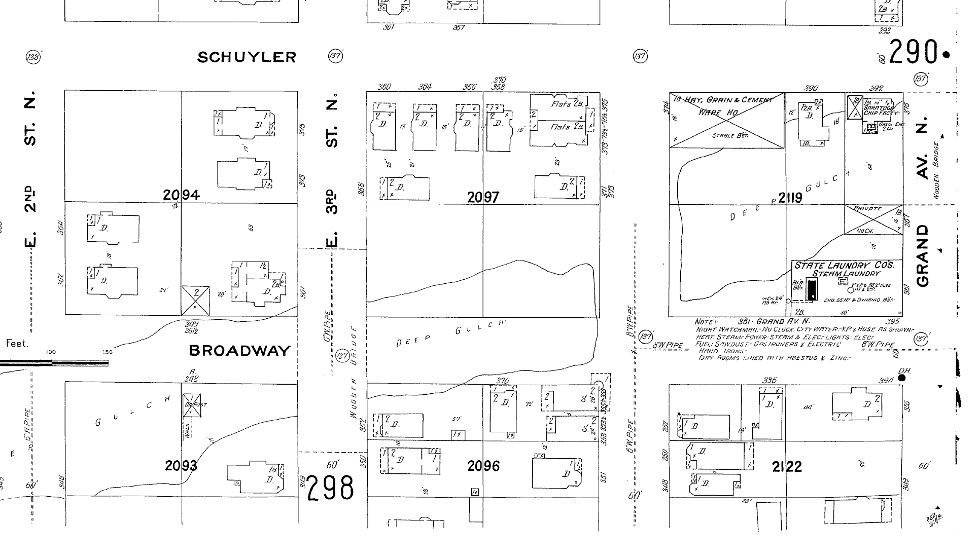
Detail from plate 289, Sanborn Fire Insurance Map, 1909
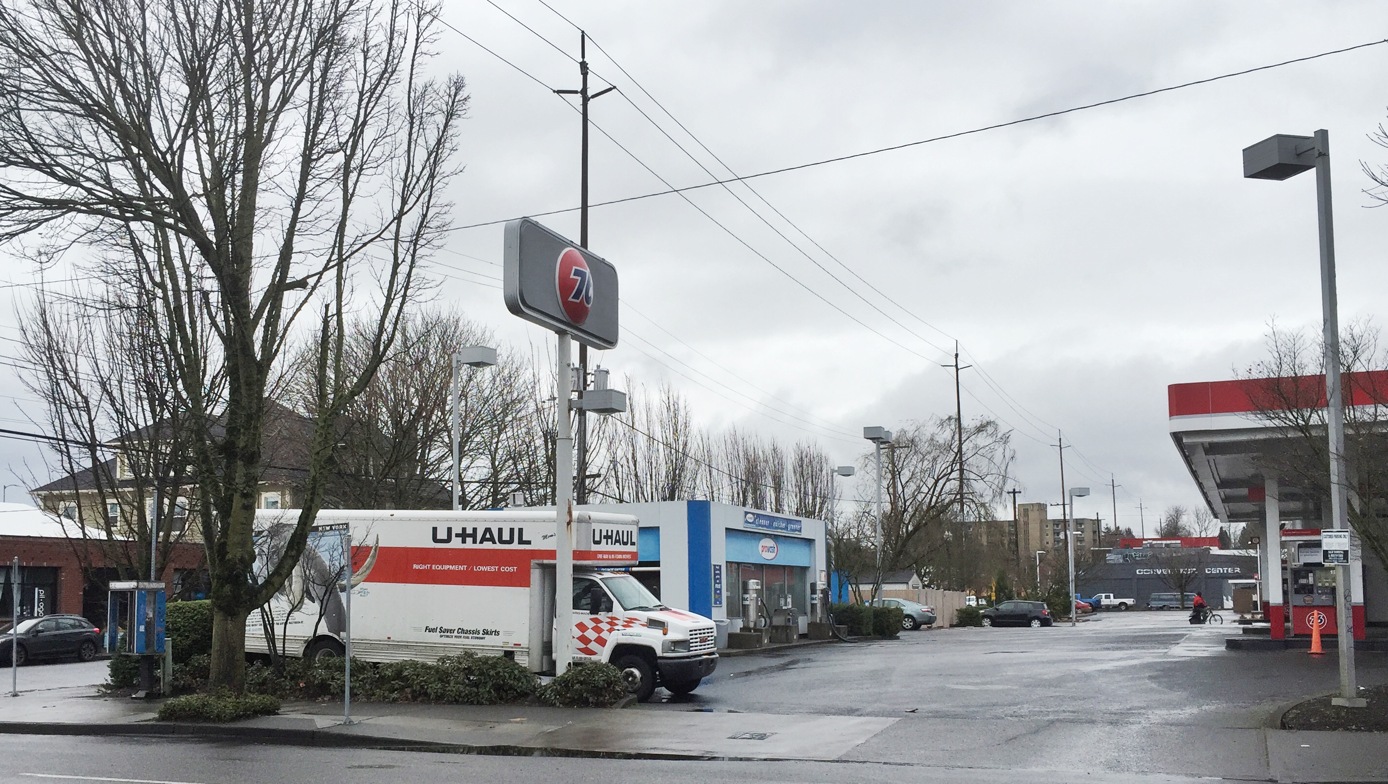
Everything in this frame from 1909 is absolutely gone today—the gully, the buildings even the streets which have been widened—and most of us speed through here (being careful about the red-light cameras) on our way somewhere else. Below is a modern view of that intersection.
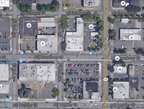
Thanks to Google Maps. Click the thumbnail above for the full photo.
* * *
Ready for an even closer look? This is the fun part where we get to try to imagine the landscape that once was, and how different it is today. As you study this photo, be sure to check out the detail: the awning style shutters; the orderly clapboard and fish-scale siding; the beautiful shingle roof; the decorative round gable end ornaments; the family members at each level; the gulch out back. The picket fence in the left foreground is running north-south along the edge of NE 3rd. The double gable end faces NE 3rd, so this view is looking off to the south/southwest at the corner of NE 3rd and Broadway.

Home of B.T. and Cora Soden, NE 3rd and Broadway. Photo courtesy of Bob Elston.
And an approximate view today:

237 NE Broadway in January 2016.
We’re able to feed this imagination thanks to fourth-generation Northeast Portland resident Bob Elston, great-grandson of Bartholomew and Cora Soden, who recently shared these and other family photos that got us to wondering about this part of the neighborhood, and to haunting these blocks ourselves in order to take a good look. Thanks Bob.
Fast forward a few years and a slightly different angle at the Soden place, this time looking west/northwest showing the barn out back, which is depicted in the 1905 Sanborn map. Note the same wooden bridge on Northeast 3rd over Deep Gulch, which keys the building into the northwest corner of that intersection. The dip of the gulch is still visible off to the left.

NE 3rd and Broadway, looking west in the late 1890s. Photo courtesy of Bob Elston.
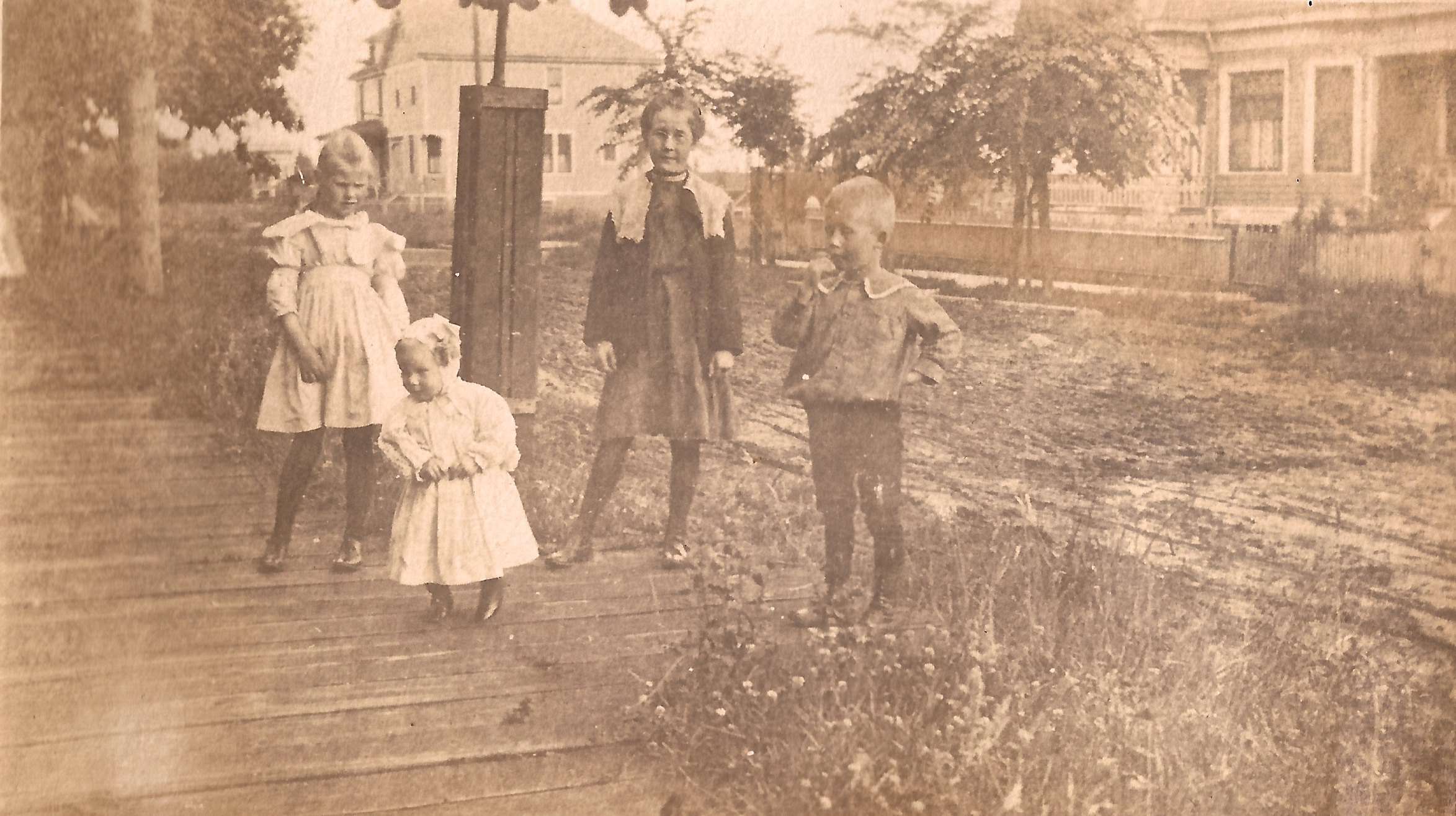
Frances, Willard, Mildred and Lester Soden, in front of the house on NE 3rd, 1898. This view is looking north on 3rd. Photo courtesy of Bob Elston.
* * *
Bart Soden was owner and proprietor of B.T. Soden Hay, Grain, Coal and Plaster, provisioner of vital goods for the eastside at the turn of the last century. His warehouse and business was located just a block east from the family home at the southeast corner of Union and Schuyler (today’s MLK and Schuyler). Scroll back up to the Sanborn map and look at it there in the upper right corner, labeled “Hay, Grain and Cement Ware HO.” Here’s a picture of Bart and a helper, probably from about 1905, showing the delivery wagon heading out on a run:
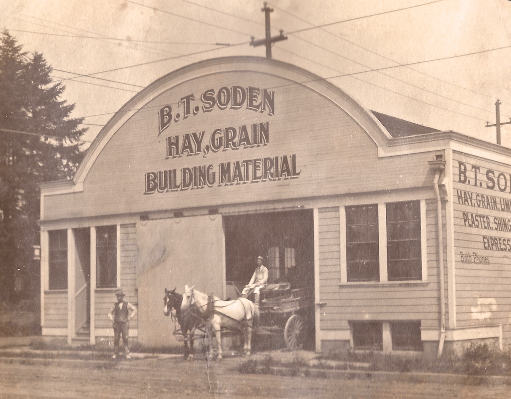
The southeast corner of NE 3rd and Union, about 1905. Photo courtesy of Bob Elston.
Here’s the same view today:
Bart was born in Australia in 1849, came to Oregon as a young boy, and grew up in rural Polk County. He earned a degree from the Oregon Agricultural College in 1879, tried his hand at teaching for a while, and eventually moved to Portland in the 1880s where he married Cora Wells, 16 years his junior. The couple built the house and business we’ve been looking at here, raised a family of two sons and two daughters, and were active in Portland society. Bart died in 1926. Cora lived until 1950. Both parents and several of the children are buried in the family plot at Portland’s historic Lone Fir Cemetery.
We’ve recently come across a memoir by a Portlander who grew up a couple streets over about the same time as the young Sodens. Stay tuned for his observations, which will continue to help us bring this long lost landscape back to life.


Really, really interesting Doug.
What happened to Deep Gulch… duh, yes, it’s filled in. When did the filling occur?
Short answer: 1912-1913 in conjunction with all of the eastside upgrades associated with the opening of the Broadway Bridge.
Medium answer: Portland’s eastside, particularly where the slopes tapered down to the Willamette River, was heavily cut and shaped by these gulches, many with seasonal streams or wetlands along the bottoms. Sullivan’s Gulch (where I-84 runs) is perhaps the most visible and well-known gulch today, but there were plenty others that posed all kinds of engineering and development challenges, including Montgomery Gulch, just northwest of the deep gulch we’re talking about in this post. The politics, financing and engineering of fills, sewer construction, street widening and streetcar routing would make your head spin. The 19-teens were a wild time in northeast Portland real estate.
Long answer: I think I need to devote a whole post to this. Stay tuned.
The Sodens, 1898. A great photograph. So alive.
Oh boy, Doug:
Third and Broadway represents some real mission creep for you. You may have to rename your project “Northeast Old House History”. I’m standing by to revise the call for photos I did if needed.
Brian
Thanks for the note Brian, glad you are following along. While Alameda is the heartbeat of so many of these stories, reflecting on how all the pieces fit together–and sparking interest in the past–is what it’s all about. As the banner at the top of the page says: “Connecting Past and Present in Portland’s historic homes, buildings and neighborhoods.” Any early Alamedan who traveled downtown on the streetcar rolled right over the top of all these filled gulches…