The Naming of Alberta

We’ve been asked recently about the naming of Alberta Street in north and northeast Portland. The short answer is that it has to do with the British Royal family by way of Canada.

But it’s also a reminder about the development of early Portland.

Alberta was named for Princess Louise Caroline Alberta, the fourth daughter of Victoria, Queen of England. Her husband was John Campbell, Marquess of Lorne and Governor General of Canada from 1873-1883. In September 1882, the couple made a swing up the west coast, traveling by ship from San Francisco to her mother’s namesake: Victoria, British Columbia, Canada. Having royals out this way was a very big deal in Canadian and American newspapers of the time.

Princess Louise Caroline Alberta about the time of her visit to the West Coast. Image source: The Royal Collection Trust, object 2903653.

Here’s where the Portland connection comes in.

About that time, our area was booming: the city we think of as Portland today was actually three separate cities, Portland, East Portland and Albina. There were similarities and some connecting common threads, but each had its own street system, addressing system, governance.

Albina, which historian Steve Schreiber reminds us was actually pronounced “al-bean-uh,” was just being platted. For more on Albina, check out Steve’s outstanding history (and his whole website on the legacy of Volga Germans in this area).

One of the developers planning Albina was Portlander Edwin Russell, who had immigrated here from England and was manager of the Bank of British Columbia in Portland. Russell had his own connection to royalty, having descended from the Duke of Bedford.

As Russell planned streets in the new suburb called Albina (and on a plat called Albina Heights), he named one street after himself: Russell; one street after his business partner: Williams; and one street after Princess Louise Caroline Alberta, whose visit to the region was causing a stir, particularly among Queen Victoria’s emigrated loyal subjects. The Princesses’s multiple names were being applied to geographic features all across the western map, including Lake Louise and the Canadian province of Alberta.

Later, as Portland expanded east of today’s Martin Luther King Jr. Boulevard, the street named Alberta expanded east too.

Another Williams Avenue View – Looking South

We’ve come across another outstanding early 1900s vantage point from Williams Avenue that you’re going to want to see (thanks Norm). This one is a nice southward-looking companion to the northward shot we featured a few months back. Be sure to study both and to take a good look at the Sanborn we assembled to get a feel for this long-gone place that was once a hub of activity for this part of Portland.

First, have a good look at the south view; then check out the north view that we’ve seen before. Then let’s discuss.

Looking south on Williams Avenue from Graham. Photo courtesy of Norm Gholston.


Looking north on Williams Avenue from Russell. Photo courtesy of Norm Gholston.

What do you see?

Let’s start by looking at the northward image, where you can just about see where this southward view was taken. See the picket fence that appears below the steeple of the Immaculate Heart Church and the bushy tree? Nearby, check out the utility pole that is leaning toward the street.

Now, look at the southward view: there’s the picket fence and the bushy tree behind our man in the hat scratching his face (and the leaning utility pole). That should help put things in perspective and establishes the photo was taken from the corner of Graham and Williams.

The crank on the pole (you can see others like it in the northward photo) allows for periodic maintenance of the carbon arc streetlight hanging overheard.

Look how fresh and clean those curbs and sidewalks look. Chances are they were built by Elwood Wiles, a household name you can still see today stamped into sidewalks all over the eastside.

The Willliams Avenue streetcar tracks owned the middle of the street, with streetcars headed north/south to St. Johns, which were shifted over to Union Avenue about 1911. No automobiles to be seen.

Look at all the awnings: in the southward photo shading the west side of the street from morning sunlight (and it might still be somewhat early judging on the length of the shadows that spill out into the street).

Check out the onion-shaped dome from the old Hill Block building at the corner of NE Russell and Williams, which can be seen today in Dawson Park. That intersection was the center of the universe for early Albina and a crucial part of the African-American cultural landscape well up until when it was torn down in 1969. That block has been vacant ever since, but planning conversations are underway.

Albina’s Williams Avenue, 1909

The loss and complete transformation of what was once a vital Albina main street will always haunt this North Portland neighborhood, in so many different ways. Important chapters of Portland history have played out here, from the early days of being its own city before becoming part of Portland, through waves of immigration, to Civil Rights protests and the vibrancy of African-American owned business, life and culture.

Today, if you don’t know this history, you might drive north on Williams past Emanuel Hospital and not know you are traveling through a kind of sacred ground.

To help us imagine this lost place, here’s a pretty amazing photo from AH photo friend Norm Gholston, and a then-and-now shot we matched up during a recent outing. Norm shared this great old pic recently: it’s the image side of a “real photo” postard, popular in this era. Click to enlarge and take a good look.

Taken from just north of the intersection with Russell Street, the 1909 photo features a look at the Kennard and Adams department store on the left, which carried a little bit of everything. The first intersection in the distance is Knott Street. That’s the Immaculate Heart Church steeple at Williams and Stanton you can see in the distance, the only common denominator that really jumps out at you from the two photos (known back in the day as St. Mary’s Church, not St. Mark’s as the Sanborn implies).

Here’s a composite of several Sanborn maps we put together to be able to visualize where Norm’s 1909 photo was taken. The red box indicates the approximate photo point. Click to enlarge.

Details from Sanborn plates 268, 273 and 274, from 1909.

If you ride, walk or drive this way—or if you didn’t know the history of this amazing stretch of street—take a moment to check out the following  multiple sources of insight about what this neighborhood meant during its heyday, and how its loss has affected the people who knew it:

Historic Black Williams Project

An article about Albina in the Oregon Encyclopedia

A nice rewind that looks back across the years by The Oregonian

Parlor stories

It’s been a quiet year so far on the AH blog, in deference to a busy batch of research for home owners and architects, several presentations, and ongoing exploration of our standing lines of history inquiry. We’ve been saving up some favorite old photos sent our way by history friend and photo collector Norm Gholston. Here’s one you’re going to want to take a close look at: the interior of a home in the vicinity of North Albina and Webster just after the turn of the last century.

Click in for a good look and then let’s take it apart in the way we like to do with Norm’s great old photos.

Part gallery, part living room, part library, apparently part dining room, this room is dressed to the nines. These picture rails are fully engaged with local art: Mt. Hood, the Coast, maybe the Columbia River.

The mantlepiece tells multiple chapters of the family story and serves as home for the heirloom clock (and the rabbit). Our very favorite thing in this whole picture is the yawning baby on the wall.

Formal table setting, with two forks at each plate, cloth napkins, the good china. Are the flowers silk or the real thing?

The texture of the plaster—and the various cracks and wear marks—make us think this house has seen a few years. And interesting fireplace: we’ve never seen a wooden fireplace surround quite like that one with corner trim that steps back following the line of bricks.

Bookcases filled. Thin carpet. Painted antlers. Victorian parlor lamp. So much to see.

The actual location of the house remains a bit of mystery. Norm tells us that on the back of the photo is written the address “5021 N. Albina,” which is curious for several reasons:

The address format is post-address change, meaning someone wrote that on there after 1931, which certainly could have happened. But the photo appears earlier than that to us.

The current building at that address is a mid-century brick duplex at the southwest corner of N. Albina and Webster…definitely not this place.

A look back at aerial photography of that corner in 1939 and in 1925 shows a vacant lot, as does the 1924 Sanborn map.

Could be that this is the interior of a house that stood there but was demolished before the 1925 aerial photography, but why would someone write 5021 Albina on the back given that it was never known as 5021? Hmm.

So we’re glad to consider this the interior of a house in the neighborhood from the turn of the last century and leave it at that. One of those mysteries that may never be solved. We like to solve them, but we’re glad just to continue contemplating too.

Filling the eastside gulches: “The last stand of the frontier in Portland”

Yes, we’re diverging a bit from old houses, but our recent foray into Portland’s lower northeast side has been interesting, plus at least a couple of our readers asked a good question: so when did that happen?

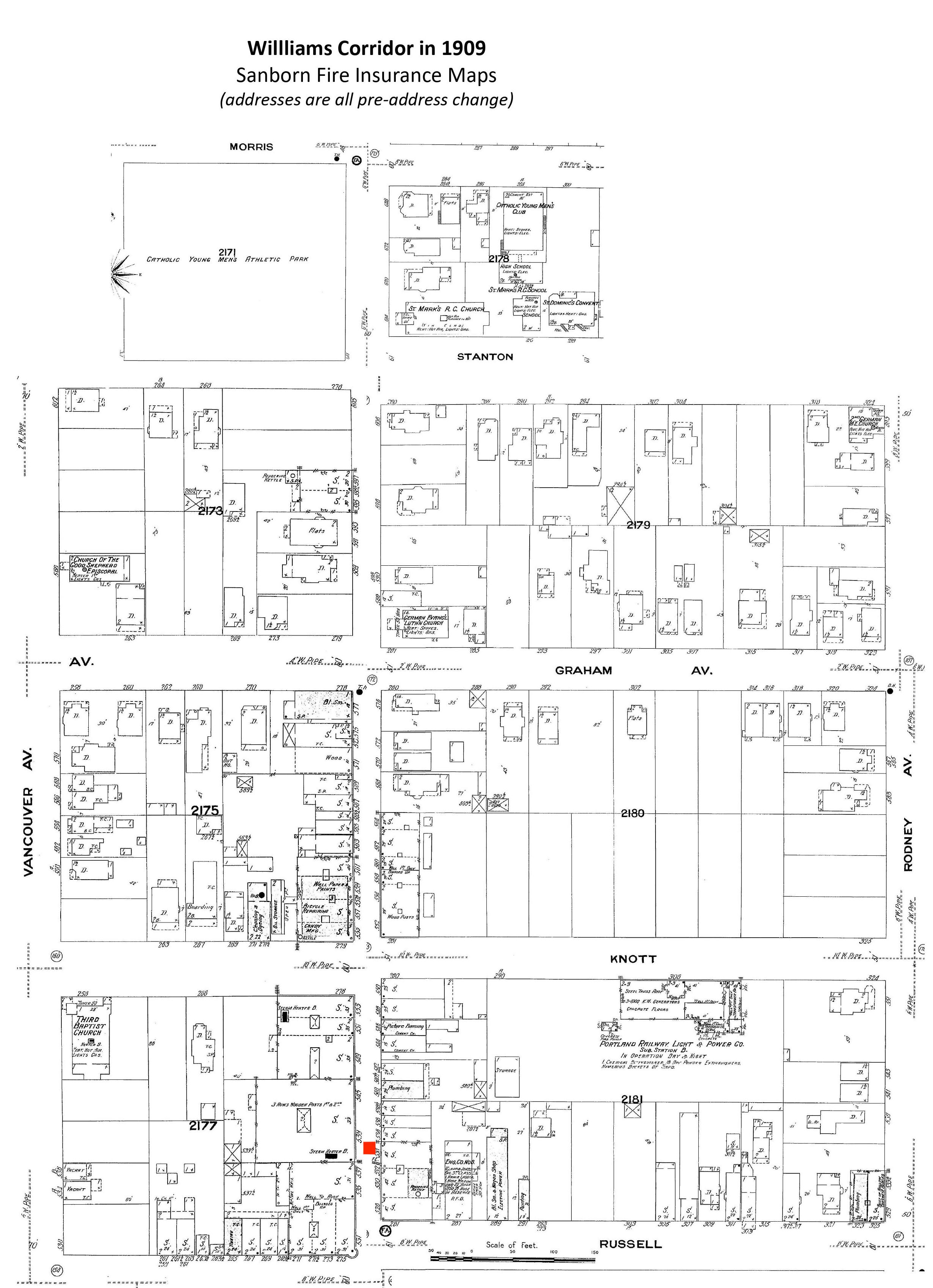
We know from our recent look at the 1909 Sanborn maps that the western edge of Portland’s eastside represented a major challenge to turn-of-the-last-century developers and engineers. Everywhere the land met the waters of the Willamette and its tributaries–and in the upslope transition to the relative plateau we consider today’s eastside–the land was marked by gulches, gullies, ridgelines, swamps, seeps and seasonal creeks.

Sanborn maps from 1909 referred to these areas simply as “deep gulch” which was less a geographic place name than a kind of short-hand for you’re gonna have some work to do if you want to build here. Sanborn didn’t show topographic lines, locate waterways or note other natural features. Just white space implying terra incognita. Interesting that for a fire insurance map, they didn’t consider the fire hazard coming up out of the gulch: lots of summer news stories from those early days of gulches on fire and nearby homes being threatened.

So if you’re like us, you want to know a little more about the extent and location of these places. Click around in the Sanborns below to look at some of the deep gulches in Eliot and Lower Albina. You’ll recognize the street names: some of them still don’t go through today because of old fashioned topography, and of course there are two major sports arenas, a hospital and a major interstate highway that have reshaped the landscape too. Still, have a look to set the table for the story of development that follows and the memories of a little boy who grew up playing in the gulches. And if you’re interested in learning more about Portland’s “hidden hydrology,” take a look at this cool set of maps we came across while looking around.

img6

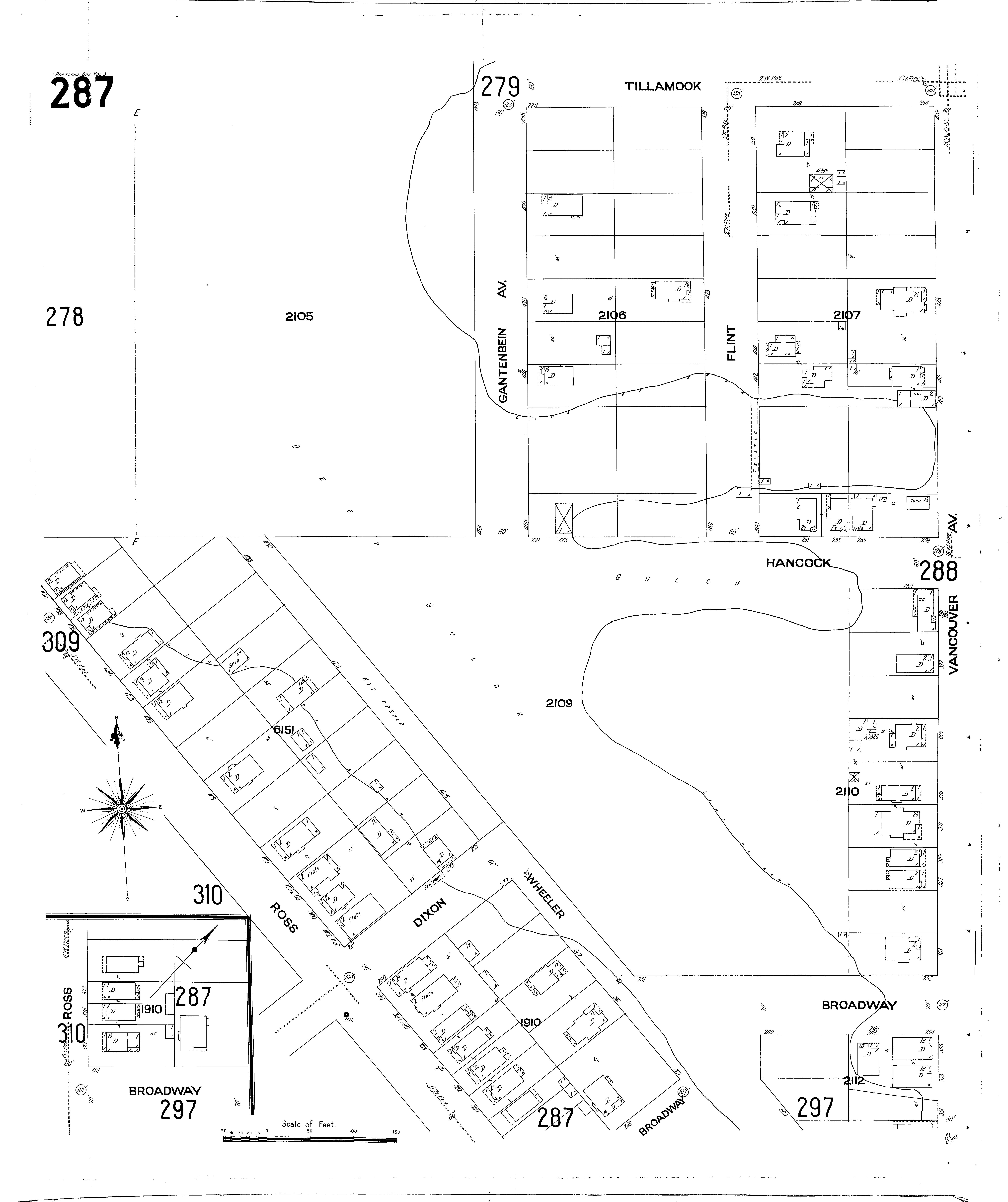
Here’s the area around today’s Portland Public Schools building off Dixon in Sanborn Plate 287 from Volume 3 in 1909. If you venture around this vicinity today as we did recently, you’ll see the line of bank hasn’t moved a whole lot, but the bottom of the gulch has clearly been filled. For a comprehensive discussion of the development of this area, check out Roy Roos’s excellent book The History of Albina.

img6

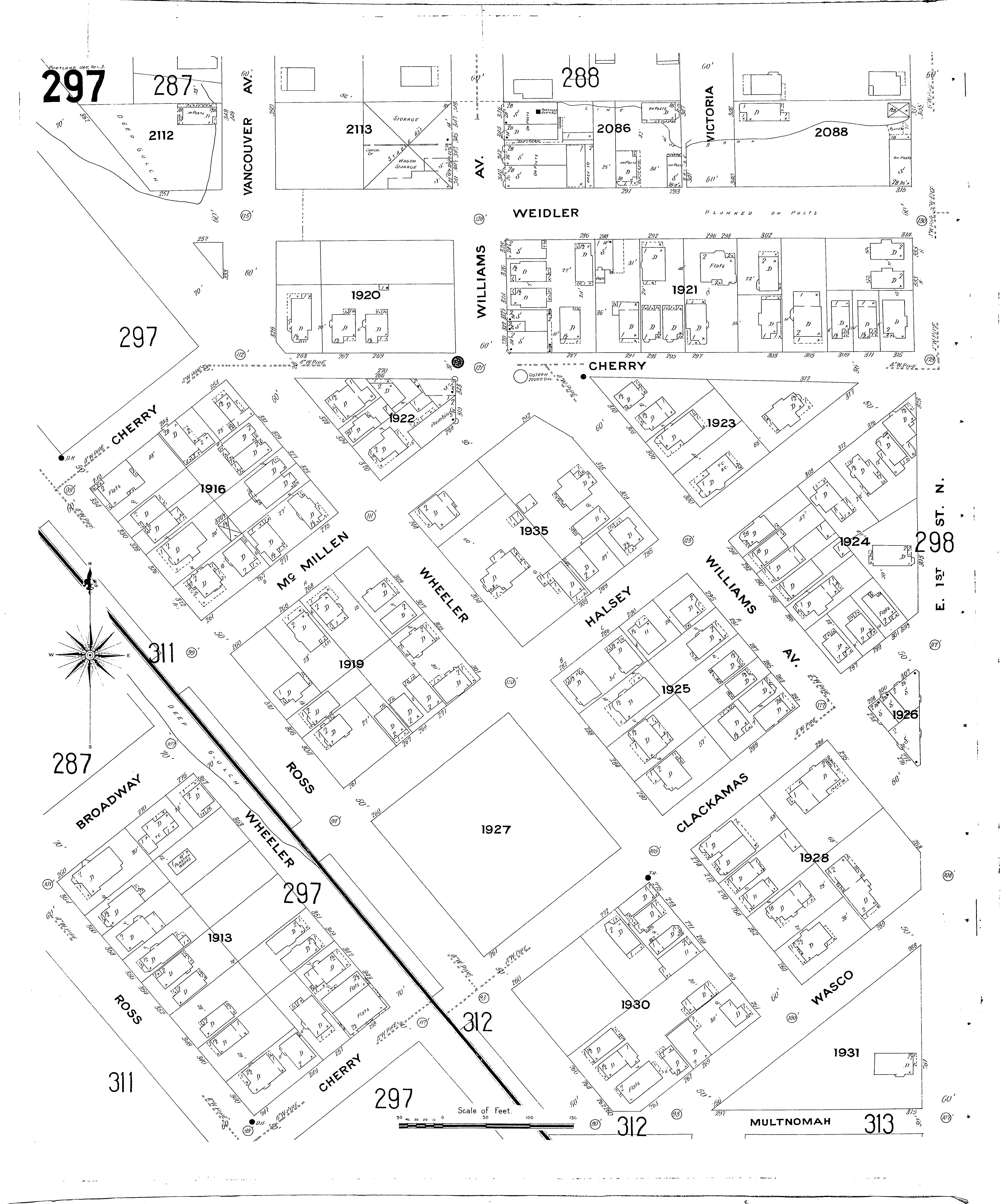
In Plate 297 above, you see a channel toward the bottom of the map at the “intersection” (we use this term loosely because these were little more than gravel traces, not engineered roads at the time) of Wheeler and Broadway, and an east-west hollow up toward the top all along Weidler, where Sanborn notes that either the street or future buildings, or both, were planned to be built on posts. Bring on the engineers!

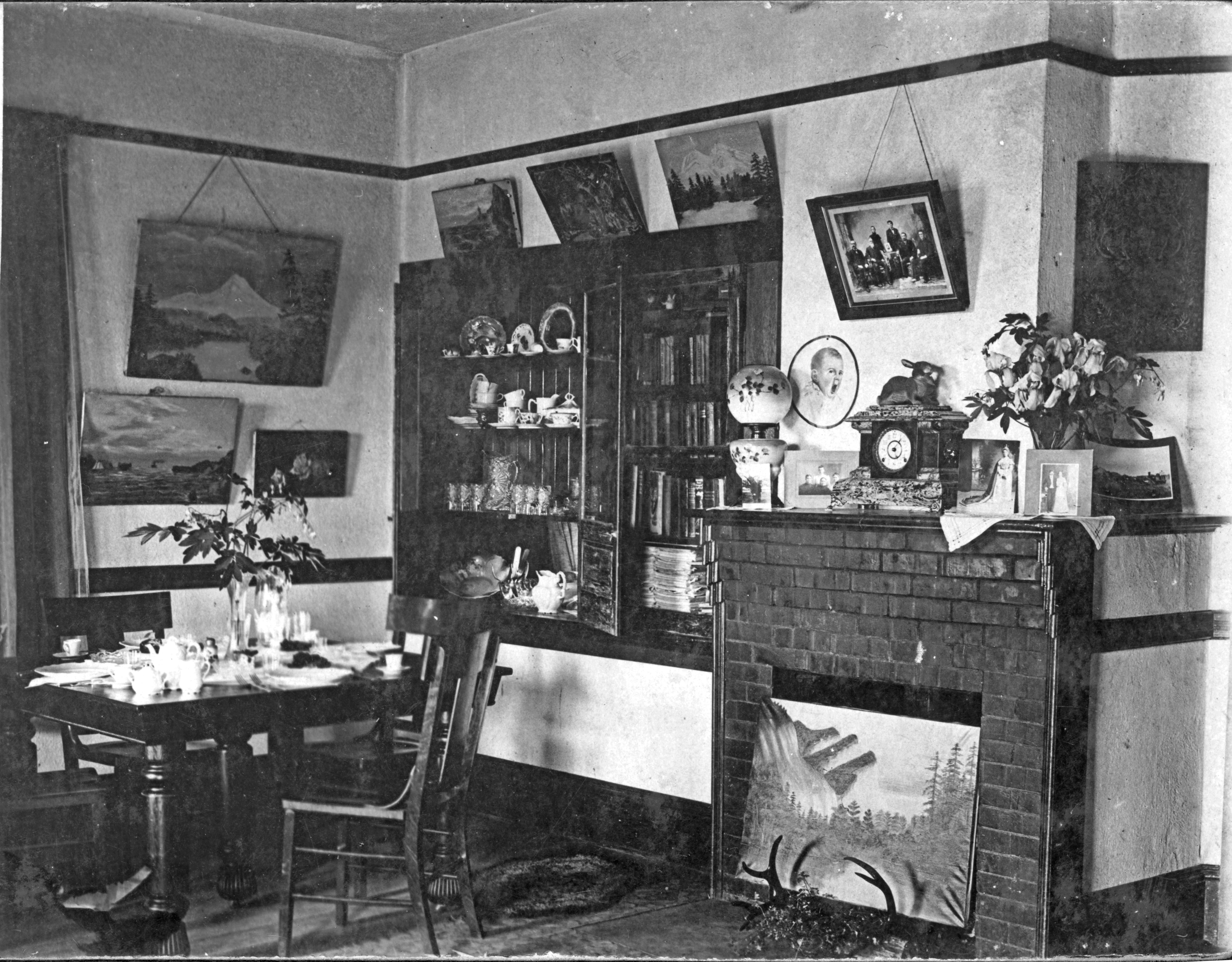
Let’s hear from Edward W. Coles, who grew up on Hancock Street, one block from this terra incognita, at today’s 77 NE Hancock. Coles was an adventurous schoolboy at the turn of the last century. His explorations and memories are collected in a self-published volume called These Were My Days. In just over 90 pages, he brings Portland day-to-day life of the 1900s into very clear focus. It’s great reading: a time capsule, really, that we’ll draw on again down the line. Here he introduces us to one of the most memorable afternoons of his entire life, which happened in Montgomery Gulch at the foot of Hancock Street.

One of my most unusual experiences happened when I was in my early teens. Ecology was not a concern in those days. They threw most anything down the hill into Montgomery Gulch. [My friend] Orlo and I would go down after school looking for anything we could use. Once, there was a piece of galvanized pipe 2 feet in diameter and 15 feet long which was lying on the side of the hill. He dared me to slide down the inside.

I put both arms against my sides and slid down. The only trouble was that the lower end had dug in the dirt and I couldn’t get out. I hollered and Orlo tried to move the pipe but it was too heavy. Then he got frightened and left, leaving me stuck in the pipe. I thought he was going for help. I wondered what would happen to me: maybe I would starve or maybe the rats would crawl into the pipe when they saw I was helpless. I screamed but my voice only echoed against the pipe. I was frantic, and I was sure that my days were numbered.

In the meantime, Orlo went to his home. Eventually my mother called me for dinner. No Edward. She had all the neighbors hunting, but no luck. Orlo had never said anything to anybody; he was too frightened. They called the police, but no luck. Then, one lady said that she saw me with Orlo early in the afternoon and that Orlo must know something. Finally the policeman frightened Orlo so badly that he confessed where I was. By that time it was getting dusk, and four or five men went down to the Gulch and pulled me out. I had been in the pipe for over two hours; I was almost out of my mind. I never thought I would get out of there alive. I was in bed for two days and had nightmares for months.

About that time they decided to put Montgomery Gulch to some good use, for valuable industrial property. They used hydraulic mining equipment: a giant hose and nozzle and lots of water at high pressure. A drain was made to the Willamette River, but after several weeks they had dead carp. The odor was awful. However, they eventually got it all washed down and smooth, all near the railroad and the river.”

Montgomery Gulch was a geographic place–you can see it there in Sanborn 287–and it was perceived as a major impediment to development. Named for James B. Montgomery (1832-1900), a railroad and real estate business leader and Oregon legislator who was a force behind the development of Lower Albina. Here’s a story from The Oregonian on November 13, 1914 describing ongoing challenges with filling Montgomery Gulch (note the salute to young Coles and his playmates down in the third paragraph):

img6

While these rough places on the bluffs may have meant adventure (and a scary afternoon) for young Coles, real estate developers had bigger issues. For them, the transportation and infrastructure challenges meant property with less value, and obstacles for higher value properties they were trying to sell. Gulches elsewhere in Portland were being converted to sewers draining directly into the Willamette. Some were open garbage dumps. Others were bridged by long trestles for roadways or rails. Whatever the strategy, a growing Portland needed more flat land and was ready to do whatever it took to solve the gulch problem. Here’s a quote from The Oregonian on March 3, 1905 that summed up the sentiment of the day:

“Around Vancouver Avenue and Weidler and Victoria streets is a deep gulch that runs down from Irvington. Into the gulch is dumped debris of all kinds. A row of buildings backing upon the gulch are said to be without proper sewerage. Complaints and remonstrances to the authorities have availed naught, say the neighbors.”

And a letter to the editor from November 6, 1912:

“Why could not all the refuse be dumped in some deep gulch and then have a crew of men grading on the mountain side closeby and dumping their earth on the garbage? Earth will purify any putrefaction it comes in contact with. Signed, O. Hempstead”

To the question of differential property values of gulch vs. non-gulch—and who pays the cost of improving infrastructure—some developers wanted to put the entire cost only on those owners whose sloped property was in need of improvement. Many on the eastside argued to spread the cost across all owners who would benefit.

Ultimately, as Portland’s population grew and property values increased, the city figured out how to contract the substantial grading and fill work. Fill was brought in from elsewhere on the eastside, and the city undertook a major project of widening and lighting Northeast Broadway to coincide with opening of the Broadway Bridge on April 22, 1913. Here’s an article from June 30, 1912 about big changes to the gulches, the streetcar line, and to Broadway itself:

6-30-1912 Fills Planned

By the time the Broadway Bridge opened, most of the curbs and streets were in place up here in Alameda. Sewer lines were in and streetcar lines and local businesses were starting to bloom. The grid was in place, the gulches filled, and the first steps were taken on the uncertain path to the future.

%d bloggers like this: