Alberta Lodge: Rescued and revived

Walking and wondering about history go hand-in-hand, especially here in Northeast Portland. On a recent adventure down Concordia neighborhood alleys, we came across a distinctive building at the corner of NE 23rd and Sumner that made us wonder: what was that? Too big to be a family house; too small and house-shaped to be an apartment building. Maybe you’ve seen this and wondered too. Take a look:

5131 NE 23rd Avenue

When you stand and stare for a moment, many possibilities come to mind: hostel, church, school, chalet, rooming house, theater. Hmm, what could it be?

How about fraternal lodge?

Yes, the two-story, bracket-eaved old beauty was purpose-built in 1923 as the home of the Alberta Lodge Number 172 Ancient Free and Accepted Masons. Here’s the news from July 1923 about the ceremonial placing of the cornerstone, and a construction rendering of the building:

From The Oregonian, July 8, 1923


Those big gable-ended walls at front and back: they’re made out of concrete, formed and poured in place (all four walls are concrete, making moving a window or door no simple task, just ask the current owners). Inside, there were small rooms and chambers for the various aspects of the secret Masonic rites, and a beautiful theater-like gathering space. A kitchen, offices, cloak rooms.

During its heyday, the Alberta Lodge No. 172 had 450 members and was jammed busy on multiple nights each week, often with a ceremony and the many social gatherings that preceded or followed: picnics, breakfasts, dinners, work parties.

In 1986, with Lodge membership dipping to just 150 members—most of them senior citizens—the Masons decided to sell the building and consolidate several other shrinking lodges under one roof in Parkrose. Masonic elders came to reclaim the ceremonial cornerstone and extinguish its service in one last ceremony. A January 14, 1986 news story in The Oregonian quotes the wife of one former Alberta Lodge leader: “It’s been our whole life.” Another, reflecting on our changing society: “People live a different lifestyle these days. All the fraternities are dwindling.”

Click to enlarge. From The Oregonian, January 14, 1986. 

Following its time as a lodge, the building was the Fellowship Church of God until 2005 when that growing community moved first to the Doubletree Hotel near Lloyd Center then to a new and larger facility on NE 122nd. The space was rented on and off for several years, and served as the home of Heaven Bound Deliverance Center before slipping into receivership and an accumulated ocean of deferred maintenance.

That’s where current owner Randall Stuart and his colleagues found it during their search for just the right building to serve as a convening space for art, theater, music, learning and community.

The 8,000-square-foot concrete building was headed for demolition when Stuart and his team purchased it in 2013 launching a two-year renovation effort that involved restoring virtually every surface and moving part in the place. And then some: new interior walls and spaces, including a major interior stairway; an ADA ramp and exterior access; outdoor spaces and landscaping; a total overhaul of building systems.

Prior to finding the Alberta Lodge, Stuart and his colleagues had formed the foundation that now runs it: Cerimon House is a 501(c)(3) humanities organization dedicated to creating and celebrating community through arts and humanities.

“It’s definitely been a labor of love. Our board is very proud of saving the building and keeping it aligned with a fellowship mission” he says, tipping his hat to the generations of Mason families who have gathered in the space.

Today, the old Alberta lodge building is definitely back to life as gathering space for art, music, readings and lectures—and lots of other interesting events, including weddings, meetings and family gatherings (the space is available to rent). Stuart invites neighbors who want to see inside Cerimon House to book a tour online at the website or take a virtual tour to learn more: www.cerimonhouse.org

Before Concordia there was Irvington Park, and an even deeper history

We’ve had the opportunity recently to look into the origins of what is known today as the Concordia neighborhood, and even though it had different names way back when, no big surprise that today’s neighborhood draws its name from nearby Concordia University.

Opened in 1907 on six acres of land that was then at the edge of Portland city limits, Concordia College was a simple two-story wood frame building home to the Oregon and Washington District of the Evangelical Norwegian Synod. Operating primarily as a high school program for young men until the 1950s, Concordia gradually evolved into a junior college, added a co-ed mission and additional facilities in the 1950s, and became a full-fledged four-year college in 1977.

Here’s an article from The Oregonian on December 15, 1907 that provides some context and mentions a few early references that AH readers will recognize. Have a look (click to enlarge).


We’ve written about that stop at the end of the Alberta carline mentioned above, which was the corner of NE 30th and Ainsworth. Check out our post and a 1944 photo of the streetcar parked there.

So ok, no big surprise about the Concordia name we know today. But peel back a layer of history to reveal earlier names, and it gets interesting.

Back then, if you lived in the area north of Killingsworth and south of Dekum between 20th and 33rd, you would have told someone you lived in Irvington Park (not to be confused with Irvington), or maybe the Town of Creighton, or the Heidelberg Addition, or even Foxchase, all place names making up today’s Concordia neighborhood that stem from the title of survey plats filed by the real estate operators who gridded out the fields and forests on these gentle south slopes above the Columbia River.

The Town of Creighton (like the Town of Wayne adjacent to Alameda) wasn’t actually a town, more like the idea of a town, hatched by property speculators in 1883, drawn out as a kind of map and filed with the Multnomah County surveyor. Remember back then this neck of the woods was well outside the city limits. The Town of Creighton plat is unrecognizable today: its tentatively drawn tree-related street names didn’t carry through time: Maple, Walnut, Beech, Locust, Birch. Creighton’s only legacy is the location of boundary lines on today’s map: north of Killingsworth, east of 25th, south of Rosa Parks and west of 33rd.

Take a look below at the Irvington Park plat, filed in 1890 and trading on the name of Irvington, a subdivision south of Fremont (the same one we know today). Note that in this view of the Irvington Park plat, west is up. You’ll see some familiar names, and some that didn’t make it through the years, Click to enlarge, it’s a big file:

Maybe you’ve figured out that “Riggen Street” is today’s Holman, and that “North Street” is Rosa Parks Way. 33rd on this plat is actually today’s 32nd place and 34th is 33rd. Details, details.

One of the interesting aspects of Irvington Park was how aggressively real estate man F. B. Holbrook marketed it during its early years, and how he coat-tailed on Irvington, located more than a mile south as a crow flies, which he had no actual business relationship with. Have a look at this ad, which ran in The Oregonian on July 10, 1907:

And here’s another gem, from September 16, 1907.

Yes, there were lots of trees: a nice way of saying this subdivision was way the heck out there.

Trading on the name of someone else’s success wasn’t a new idea. Alameda Park developers did the same with their own outrageous 1910 brochure, plus when Alameda was plumbed for sewers back in 1910, they even attempted to freeload (so to speak) on Irvington’s existing sewer system.

Even The Oregonian got into the act of promoting Irvington Park. Here’s a piece from July 23, 1913.

There’s a fascinating history to the Irvington Park lands that runs deeper, to 1866 when 49 acres were transferred from the United States government to Henry McIntire as part of a bounty land claim deed that was a reward for McIntire’s military service. The lands changed hands quickly after that, owned briefly by a private individual, then by Willamette University, and then by the Salem Flouring Mills. During the early 1880s the lands were even owned by William H. and Jennie Creighton (of “Town of Creighton” fame) before they defaulted on a mortgage payment to the Salem Flouring Mills. Mr. Creighton started out as a produce and shipping broker and proceeded into real estate speculation, as it seemed every Portland businessman did in those days.

By the early 1890s, the lands were in the hands of an unimaginatively named group called the Investment Company, owned by big-time Portland developers including William M. Ladd (who incidentally was a principal in the Salem Flouring Mills) and Edward Quackenbush. Selling lots in Irvington Park was just one of their many enterprises.

And deeper yet: elderly residents of Irvington Park we have interviewed report that when the ground was first disturbed to make streets and lots almost 100 years ago, Native American objects and artifacts were frequently found, which makes sense given the proximity to the Columbia Slough and Columbia River. These lands, like every inch we live on today, are part of the ceded lands of the Confederated Tribes of the Grand Ronde. Unfavorable treaty agreements in the 1850s removed indigenous people from these original homelands and then systematically broke the lands up to development through actions like the Donation Land Claim Act and related bounty land claim provisions. Any stone tools or arrowheads found today should rightly be returned to the Confederated Tribes of the Grand Ronde.

Over time, as Concordia College’s physical presence began to expand, the underlying plat names in the adjacent neighborhood fell out of usage in favor of what was becoming a local landmark, as in “we live over near Concordia,” and the previous deep history was forgotten. The mid-1970s marks the first official reference to the Concordia neighborhood that we could find either in daily news reporting or in city reference documents.

Read more about the “finest corner in Concordia,” a summer’s evening trip from 1915 to NE 30th and Ainsworth.

In praise of alleys

Here’s something you probably have not spent much time thinking about: Northeast Portland alleys.

It’s OK that you haven’t been thinking about them—it’s hard to know exactly where they are, some neighborhoods have them and some don’t. And even where they do exist, they might be hidden behind a wall of blackberry bushes, or garbage cans, or yard debris.

But now it’s time to think about alleys and to go out of your way a bit to appreciate and understand their history, demise and possibility. Along the way, we should also examine the question of why one neighborhood has them and another doesn’t. Mull that over a bit while we explore this topic.

First, an important fact about Portland alleys: virtually all of them are on the eastside.

Downtown Portland, known for its small and walkable 200’ x 200’ blocks, has never had alleys, to the chagrin over time of some business owners and public works officials who have complained that our downtown grid makes deliveries and trash removal too complicated and public. If our city blocks had alleys, they’ve argued, those essential but less desirable functions could take place out of view, giving the front of the business more leeway and prominence.

Here’s a great map that shows the extent and location of Portland’s alleys. Have a good look at it then come back here and we’ll continue our exploration.

There is at least one common denominator in this map’s seemingly random purple grid segments: they exist in neighborhoods platted before 1909. In Portland, as in so many other US cities, alleys were a utilitarian feature designed before the age of automobiles. The barn out back that might have housed a horse or wagon also contained garbage and other chaos that you didn’t want to have out front. But when the car came along—a symbol of convenience, independence and even status—garages began their migration from out back to the front of the house.

After about 1910, land development companies platting Portland’s eastside neighborhoods responded to this shift by dropping alleys and back garages from their plans. Not incidentally, this allowed houses to be a bit larger and to shift back farther from the street allowing for front yards and landscaping, as well as driveways and garages.

Alameda and its neighborhoods immediately to the north are a perfect illustration. Vernon, Elberta (not a typo) and Lester Park—the subdivisions just to the north across Prescott—were platted between 1903 and 1908 and they have alleys and 40′ x 100′ lots. Here in Alameda, platted in 1909 and built starting in 1910, there are no alleys, but 50′ x 100′ lots. North of Prescott, smaller houses crowd the street and yards are small. South of Prescott in Alameda, houses are larger and set back farther. No alleys. (Check out our Maps page and scroll down to find the original plats for Vernon, Elberta, Lester Park and Alameda Park.)

Yes, there are other contributing factors at play: Alameda has the ridge, which breaks the rectangular grid pattern. Plus, Edward Zest Ferguson and his Alameda Land Company wanted Alameda to be an upscale addition of larger homes, as opposed to the more compact homes and lots in subdivisions to the north. Irvington, for instance, platted even earlier than all of us above the ridge, does not have alleys. This was a function of the size and siting of much larger and costly homes on relatively constrained lot sizes. It’s hard to have both large homes and alleys given our compact grid.

The presence or absence of alleys was central to the question of site and building design, real estate value, and marketing potential at the turn of the last century. Throw in the advent of automobiles and you’ve crossed a tipping point away from alleys in the minds of early property developers. Why bother with alleys anymore?

So, there’s our answer to why some eastside neighborhoods have them and some don’t: it’s largely related to timing (pre- and post-1909 as the key date), with the advent of the car looming large, and a few other considerations like targeted market sector and house size. Bottom line is that after 1909, no more new alleys were built on Portland’s eastside.

Here in Northeast Portland you’ll find two types of alleys: the obvious ones that are a long straight laneway right up the middle of the block adjacent to back yards and paralleling the length of the fronted street (typically the numbered street). You’ll find these between Prescott and Alberta, from 24th to 33rd. Another form you’ll find is the tee alley, on either side of Ainsworth between NE 23rd and NE 33rd. This form provides a shorter cross alley (like the top of a letter T) that bisects the long laneway. These are interesting to explore and are in pretty good shape.

Once you start walking our alleys, you begin to see clues to the past and to future potential, and you can see how different neighborhoods have responded to their alleys. While we haven’t walked every Portland alley, we’ve explored a lot of them, and offer these observations as an enticement.

This alley is just off Alberta between NE 29th and NE 30th. Looking a bit like a gallery, the pools of light here illuminate boards that advertise the adjacent T.C. O’Leary’s Irish Pub. It’s an enticing sight.

___

Most of the alleys between Prescott and Alberta from NE 24th to NE 33rd look something like this one: muddy ruts, grass, brush ready to grow over.

___

Here’s one just north of Alberta between NE 27th and NE 28th. The entrance is crowded with garbage cans and recycling bins but adventure up a bit and you see a kind of graffiti gallery.

___

Here’s one that has grown over. Looks like that laurel bush has eaten the garage too.

___

The Piedmont neighborhood has great alleys that run south from Rosa Parks to Killingsworth between MLK and N. Commercial. Lots going on here: powerline corridor, pavement and some interesting ADUs.

___

We came across quite a few alleys that had an entry threshold like this one with the gridded pattern scored into the sidewalk. This signaled the alley opening to passing pedestrians.

___

Some alleys like this one in Portsmouth have become debris dumping zones for neighbors, with piles of clippings, dirt and other debris forming impassable mounds. No more cars up this alley.

___

This Portsmouth alley is so well used and traffic-friendly that residents have built a driveway off the alley that seems like a primary entrance to their house. No need for a front yard here.

In recent years, there has been a resurgence of interest in alleys as public spaces that connect neighbors and neighborhoods. In many ways they are a hidden resource, public spaces in out of the way places. A few years back a consortium of city planners and urban design professionals launched the Portland Alley Project, which led to several alley maintenance and recovery projects. Here’s another great blog by San Francisco urban designer David Winslow with passages from his book Living Alleys: A new view of small streets.

Check these out, look at the map and then go for a walk. Get out there into this ready-made local trail system where you can slow things down and experience a completely different neighborhood than the one you think you know.

A Concordia alley

In the footprint of Old Vernon

In the spirit of knowing that pretty much everything is connected, we were intrigued to learn of the ties between mid-century modern builder Kenny Birkemeier (1905-1996) and the old Vernon School block south of Alberta between NE 22nd and NE 23rd.

Frequent AH readers will recall the story of Old Vernon (which is one of our favorites), the giant wood frame structure that once occupied much of the block bounded by Wygant, Going, NE 22nd and NE 23rd. It’s a fascinating story of Portland’s early school building challenges, the growth of a neighborhood and the all-too-frequent fate of Portland’s early all-wood institutions. And there’s virtually no trace left even though its impact on the neighborhood during its heyday cannot be overstated. Learning about Old Vernon was a bit like a curtain going up to reveal an entirely different neighborhood that once was.

Readers will also recall that Ken Birkemeier was one of Portland’s most prolific and resourceful builders between the mid-1930s and the 1950s. Dozens of his homes, most with a distinct family resemblance of Roman brick, ornamented brick facades and whimsically placed oval windows, can be found in nearby northeast Portland neighborhoods.

So–you’re wondering–how do these stories connect?

(Spoiler alert if you haven’t already read our piece about Old Vernon…maybe you should go do that first.)

In the aftermath of the big fire, the school district contracted with Rose City Wrecking in March 1933 to haul off the burned remains and to demolish and remove anything else still standing on Block 54, which they did. An aerial photo from 1936 shows the footprint of the burned building and lots of open land.

Detail of an aerial photo from 1936 showing vacant Block 54 and the burn scar / footprint of old Vernon School. NE Prescott runs east-west along the bottom of the frame.

The mid-1930s were not a great time for homebuilding in Portland, so Block 54 sat vacant for a few years. The Great Depression killed the real estate market and tightened down on much of the available money to build or to buy. But gradually the market returned and our resourceful Mr. Birkemeier acquired the entirety of Block 54: all 18 lots.

Our review of city permits, prompted by eagle-eyed AH reader Michael Johnson, shows Birkemeier began building in October 1940 on the south end of Block 54 (2225 NE Going and 4621 NE 23rd, to be exact) and worked his way north. He finished the last of the 18 houses on that block in the winter of 1944 with a pair of duplexes at 2210 and 2232 NE Wygant.

Ken Birkemeier was a talented builder, and an effective marketer as well. Many of his homes from that era were featured in The Oregonian, including photos of the houses and occasionally of him too. But a careful review of past issues from those construction years didn’t turn up anything from Block 54.

So here’s an opportunity for you to go walk along the invisible fault lines of the past, from the long-ago schoolyard, to the brand new block of the 1940s, to the changing neighborhood of today. Make no mistake, change is our constant companion. That’s how it always has been and how it should be.  How we change will explain a lot to the future about what we value today.


Fernhill Park: From wild thicket to popular neighborhood park

It’s often the small and even random things in the past—stuff we don’t pay much attention to or think about now—that make a big difference in outcomes that shape the future.

How Northeast Portland’s Fernhill Park has turned out today is kind of like that: Peel back the layers of history and you can see why things are the way they are today. That’s kind of our broken-record message here at AH, but it’s true.

The hills and gullies that make Fernhill Park distinctive today made it less desirable for crops in the early 1900s.

One of the most prominent features of the park today, located across rolling hills near NE 41st and Holman in Northeast Portland, is responsible for it being a park at all, and probably not for the reason you think. The hills and gullies on the park’s north side, a great place to run the dog in the spring and summer or to sled in the winter, distinguish this place from other nearby city parks.

But back in the day, when much of this area was farmland, this up-and-down topography was a thicket of trees and brush and not very good for growing crops. A close examination of aerial photos from the 1920s, 1930s and 1940s show agricultural fields on all sides right up to the edges where the ground falls off into the ravines of today’s park area. So—the reasoning went—if the city really wants to buy that property from us farmers, go right ahead, we can’t grow anything there anyway.

And that’s just what happened.

After voters approved a property tax levy in 1938 to create more parks and playgrounds for a growing Portland, the city set out on a 10-year process of buying those hills and gullies, starting out in 1940 with a 10-acre parcel owned by the Jackson family right in the middle of it all.

During those years, several dirt roads criss-crossed the north side of the park, one even ran right up the bottom of the gully at the heart of today’s off-leash area in the northeast side of the park, pausing at a wide spot that served as a dump and debris field where car bodies and all manner of junk were strewn.

This detail of an aerial photo from 1940 shows the area of today’s Fernhill Park in the middle surrounded by farm fields on all sides. NE 42nd Avenue is the north-south street on the far right and doesn’t yet go through to Columbia Boulevard (it bends around the corner to the right where Holman is today). The north-south street on the left (that also doesn’t go through) is NE 37th Avenue. The east-west dirt road at the top of the park became today’s Holman Street. Paths, a road and a dump area are visible in the top center of the brush patch. Mike Brink’s grandparents’ home is in the upper right corner with the rows of trees and barn to the south. Photo courtesy of the University of Oregon Map and Aerial Photography Library.

It wasn’t an official dump, but more like a secluded out-of-the-way place where folks from the surrounding area knew they could get away with off-loading a truckful of junk if they needed to. So they did. In the late 1930s and early 1940s, when the NE 42nd Avenue connection to Columbia Boulevard was built, some of the dirt fill needed to make the grade change for the overpass was dug out from and supplied by the gully on the east side of the park along today’s NE 41st Avenue.

Prior to 1940, when NE 42nd didn’t go through to Columbia Boulevard, you could stand near the northeast corner of what is today’s park and see the Kennedy School across the fields and orchards stretching west to NE 33rd Avenue, with more open fields south to Killingsworth and north to the banks of the Columbia Slough. Then during the building boom of the 1940s and 50s, subdivisions marched east transforming the fields into neighborhoods.

Just 10 years later in 1950 the neighborhood was filling in. NE 42nd now goes through to Columbia Boulevard (look for the Tourist Cabins and the Spur Tavern…they’re there). NE 41st has been built and house construction is underway.  And Mike Brink’s grandparents have planted an orchard with orderly rows of filberts south of the house and bing cherries north of the house. Photo courtesy City of Portland Archives.

Often referred to as “truck farms” because the produce was trucked to market (and some of it was sold out of the back of trucks at busy intersections and small markets around town), these surrounding fields produced fruit and vegetables for Portland households. One farm near the corner of what is today’s NE 41st and Holman was owned and run by a Japanese immigrant family, as were others in the area. During WWII, Japanese farming families across the Pacific Northwest were removed from their land and placed in internment camps in southeast Oregon and central California.

We know from our recent visits with Mike Brink—who grew up in the 1940s and 50s in the tourist cabins at NE 42nd and Holman now about to be demolished—that the fields and orchards stretching out in all directions were filled with filberts, apricots, bing cherries, raspberries, strawberries and other crops. Mike remembers walking through them and through the heavily wooded thicket that is today’s Fernhill Park on his way to and from St. Andrew’s School at NE 9th and Alberta. He’d leave the cabins in the morning, pass by his grandparents farmhouse that stood near today’s intersection of NE 41st and Highland, then take the path through the woods and fields over to Ainsworth Street where he’d walk to the corner of NE 30th and Ainsworth, which was the end of the line for the Alberta Streetcar (you should check out this link because it shows the streetcar waiting where Mike used to catch it at NE 30th and Ainsworth). Hopping on a mostly empty streetcar, he’d ride south on 30th and then west on Alberta to school, reversing the process in the afternoon, maybe stopping at a neighbor’s house for hot chocolate on the way home. Quite a solo daily adventure for an elementary school kid, but times were different.

Mike doesn’t remember it being talked about in his house during those years, but gradually, the city was buying up parcels of the woods when bond money was available and when the locals were willing to sell. A couple more parcels in 1942 and 1943. Six in 1949.

As the park took shape through the late 1940s and early 1950s, some locals referred to it as Ainsworth Park, a name that appears frequently in real estate advertising of that era. By the early 1950s, most of the open land Mike remembers to the north of the park had been converted to subdivision (the Vanlaeken and Leitritz additions for readers keeping track of plat names). NE Highland Street was put through the middle of his family’s farm and his grandparents moved to a new house in the neighborhood as the working farm landscape they once knew was transformed into suburbia. By June of 1951 when most of the park buying was done, the city had invested $60,479 and had acquired 25.95 acres.

In this detail of a 1956 aerial photo, the family farm is gone replaced by the cul de sac that is today’s Highland Street and homes are under construction; all of the lots are built up between NE 41st and 42nd in the middle of the photo; a baseball diamond has arrived in the middle of it all; the paths, road and dump are gone. Once again, the Tourist Cabins and the Spur Tavern stand out clearly just right of center toward the top. Photo courtesy of the University of Oregon Map and Aerial Photography Library.


Contemporary view from a hill on the north side of the park, looking off into the Vanlaeken and Leitritz additions. Mike’s grandparents’ farm was off to the right.

On July 14, 1954, City Council passed an ordinance officially naming the area Fernhill Park, a name that was not in local usage prior, but that probably takes its meaning from the hills on the north side of the park.

Construction of Adams High School just southeast of Fernhill Park in the mid-1960s caused quite a stir and protest from the neighborhood. More than 150 angry neighbors turned out at a Portland School Board meeting on September 4, 1964 to share their disbelief that the School Board would demolish 26 homes, three duplexes, a local greenhouse/nursery known as Knapps and a PGE substation to make room for the school. The emotion and sense of loss in the letters and petitions submitted to the school board make for tough reading. Despite this strenuous protest, demolition of the homes and businesses went ahead, construction followed, and John Adams High School opened in September 1969.

From The Oregon Journal, September 3, 1964. The homes and businesses inside the dotted line were demolished to make room for Adams High School.

A dozen years later, when high school enrollment dropped in the early 1980s, the building was repurposed as a middle school and operated for another 18 years before being closed in 2000 due to health concerns about mold. The building sat empty and was frequently vandalized until being torn down in 2006 leaving the large open space south of the track. Newcomers to the area today might not even know that vacant piece of ground south of the track was once a school, and before that a neighborhood, and before that farm fields, and before that an Oregon Trail-era homestead.

No history of the area would be complete without taking it back to the earliest record, when this property was homesteaded under the 1850 Donation Land Claim Act, which Congress passed to encourage settlement of the Oregon country. Isaac and Mary Rennison came across the Oregon Trail in 1852 and settled on and farmed the property, filing their Donation Land Claim in 1855 that encompasses the area bounded today by NE 33rd and NE 60th, Holman and Killingsworth.

Before all this recorded history, let’s not forget that these lands on the south shore of the Columbia River and the Columbia Slough were frequented by the Native Americans who called this area home for more than 500 generations.

Interesting, isn’t it, how the places we know and care about today as our local parks came to us partly because of unpredictable events or circumstances: Alberta Park was a brush patch owned by a Chinese immigrant who didn’t want to sell, or to control the brush and trees while the neighborhood developed around it, so the city condemned the property out from underneath him and turned it into a park. Wilshire Park was tied up in a complex probate process inadvertently delaying development until the city took out a bank loan to buy the property on the eve of its being turned into a subdivision. And much of Fernhill Park was property no one really wanted anyway because it wasn’t good cropland. Today, we take these places for granted as fixtures of neighborhood life.

With these lessons of history in mind, what should we be thinking about and taking action on today that would change some future outcome about how our neighborhood feels and operates in the future? Demolition and densification? Traffic? Hmm. More on that next week.

End of Story: Spur Tavern & the 42nd Avenue Tourist Cabins

We’ve been working on the history of Northeast Portland’s Fernhill Park this week, and it’s a fascinating tale of the city’s growth during the mid-20th Century, land use change, local politics and community engagement.

But we bumped into a story along the way that we have to share first because it’s going to be the next one that goes away and we have to appreciate it briefly while we can.

We’re talking about the old Spur Tavern and the garage-like apartments at the northeast corner of NE 42nd and Holman. Here they are:

NE 42nd and Holman, looking east, April 2017. In the mid-1940s, this was a community of returning WWII servicemen and their families, temporary workers and others passing through the Portland area.

The former Spur Tavern, built in 1942, 6300 NE 42nd Avenue.

These buildings have obviously known better days. Some might call them an eyesore, with broken and boarded up windows, tilting roofs and doorways and rotting siding, all spray painted with graffiti. A small ocean of cracked and buckling pavement and gravel surrounds it all, moss growing everywhere, branches down, junk piled. And for the moment it’s surrounded by barbed wire fence. When you see fence go up around buildings like this, you know things are about to happen.

In fact, this week the City of Portland issued a demolition permit, so if you want to go look, make it quick. We haven’t yet been able to connect with the owner, so we’re not sure what’s planned for the property. But we’re guessing most people are probably not going to miss these tired and dejected looking buildings.

But it wasn’t always this way.

Built in 1942, about the time NE 42nd Avenue was connected up to Columbia Boulevard and the new Portland airbase, the “Tourist Cabins” and Spur Tavern provided a sought-after home base for servicemen and their families on short assignment and others who needed temporary quarters for seasonal jobs or as a jumping off place into the next chapters of their lives.

When it was first built, from the front door of the Spur you could look out at agricultural fields in every direction. The Cully neighborhood to the south and east was already established and growing. Off to the west, across the open fields of what is today’s Fernhill Park and the eastern edge of the Concordia neighborhood, you could see the Kennedy School. To the north, more farm fields and dairies around the Columbia Slough and a beehive of activity at what was fast becoming the Portland Air Base and the new Portland airport.

The close-in fields and orchards were the livelihood of local families. One family of immigrants from Croatia lived in a 1917 farmhouse at the corner of today’s NE 41st and Highland Street (there was no Highland Street then). Home to the Anna and Josef Ugar family, this farm residence was completely surrounded by fields and orchards, with the nearest neighbor a quarter mile off to the west. You get the idea: this was the outskirts.

One young person who knew this place well and loved it for the adventure, family and community it provided, was Mike Brink, grandson of Anna and Josef Ugar. Mike split his growing up years between his grandparent’s farmhouse just to the west on the hill overlooking the fields, and the “cabin” at the far north end of the line of connected apartments.

Mike’s dad Bill was from Cascade Locks. In the 1930s, while helping build Bonneville Dam, Bill married Kay Ugar. After Mike was born, Bill  shipped off to World War II, so young Mike and his Mom Kay headed home to the Ugar family farm in Northeast Portland. When his dad returned from the service, the young family stayed local, moving across NE 42nd Avenue to rent one of the tourist cabins.

Mike remembers:

“5 million men came home. Many to wives and families they hadn’t seen in years. There were no jobs. Insufficient housing. And many other societal problems. The cabins served a vital function for us. They were a virtual community. Everyone was in the same boat. Those of us who were there for a longer time formed close bonds. The Spur Tavern was a social hub. Some had difficulty finding work and spent too much time there. Others spent all their free time there. Weekends could get out of control at times.”

Mike recalls the modest means of many cabin residents, and how from time to time when rent was hard to come by, the landlord Al Druery, who also ran the Spur Tavern, would cover a family who needed help with groceries until payday.

“He [Al] also collected the rent for the cabins. He lived in the end cabin—#1 – right behind the tavern. I remember him as a harried looking man who looked like he drank too much himself but I don’t remember anyone ever having a real problem with him. I remember if we were low on milk or coffee or bread or some other staple my mom would send me over to the Spur and they would give me what ever we needed and put it on our bill. And all of us worked together to convert the garages to additional living space and finish the interior. Then there would be a big party. There was a rotating weekly pinochle game. It couldn’t have been too bad.”

Mike recalls how the long line of cabins used to include garages, but residents gradually converted them to living space, which was a premium as families grew. Here’s a current photo, and memories from Mike that help evoke that life and times:

Cabin # 7, 6300 NE 42nd Avenue, April 2017. Note the daffodils by the front door, a remnant of more optimistic times.

“We had a ‘hide-a-bed’ couch in the little room you can see through the partially open door. My folks made that up each night and slept on it. I slept in the area to the left of the door on an old wooden and canvas fold up army cot that we made up each night. There was a small table and three chairs behind the couch and a little kitchenette along the back wall. In the northeast corner was a really small ‘bathroom’ with a shower. It was so small my grandfather commented when he came to visit for the first time, ‘That bathroom is so small you have to decide what you are going to do before you go in.’”

“The area to the right of the front window was the garage for the unit next door. There is a wall there now because after a year or so, when that unit became vacant, my father persuaded the landlord to let him enclose that area and finish the inside. We moved into that unit and the finished garage became my parents bedroom. I then got the hide-a-bed in the ‘living room’ of that unit. It also had a real bathroom and a bigger kitchen. We lived there until 1949-one social strata above the Joads!”

The Spur Tavern was the proverbial watering hole where residents of the cabins, servicemen and people passing through stopped in for a beer and a snack. Mike remembers:

“The Spur was a busy place. It was a ‘beer joint’ in the truest sense of the word. A long bar with round swivel seats running south to north with the bartender behind the bar facing west. Pickled eggs in jars on the bar along with ‘punchboards.’ Two pin ball machines and a juke box in the north end. And cigarette smoke so thick I’d have to squint to see my dad when I went to get him. There were a few plywood booths along the west wall and in the south end. There were rest rooms in the southeast corner with a door going out back to the east. They had sandwiches and pickles but I don’t remember any chips. They made coffee but only in the morning and at night. I remember for a while they had ice cream and made milk shakes. But, no one went there for the food. During the period right after WWII jobs were scarce and the Spur was busy pretty much all day. Most of the patrons then, and I remember they all were men, were mostly guys just ‘hangin’ out’. Sippin’ a beer or two, or three. There was rarely any trouble. Evenings were about the same. A little bigger crowd 15-20 maybe, a little noisier but rarely rowdy.  On the weekends, though, it could be busy and noisy and go on late—loud music, loud voices, cigarette smoke and honky tonk women. There were some loud arguments and some fights but I never knew of anything to get really out of control. I think the real problems came much later when the the drug culture took over the cabins and the Spur. I think it had a pretty well known reputation as a crack house.”

Newsprint and photos are always helpful to record the facts, but personal memories like these are what keeps places known and alive, so even after the Spur and tourist cabins have been demolished and hauled off, many indelible memories for Mike Brink will linger on, including this last one related to the end of World War II:

I still remember V-J Day. I was playing catch with my friend Bobby Collins in front of the cabins and traffic on 42nd Street got very heavy with many cars going very fast in both directions, the drivers honking their horns and people hanging out the windows and yelling. I’m sure you know 42nd was the main axis route to the air base. It scared the hell out of me. I ran in the house (cabin) and my mother had the radio on and told me the news.

Thanks for the memories, Mike. We’ll hold onto these so the future can remember the past.


Northeast Portland’s Foxchase: What’s in a name?

If we asked you to find Foxchase on a map, could you?

Here’s a clue: it was one of a dozen different subdivisions created more than 100 years ago that taken together today make up what we think of today as northeast Portland’s Concordia neighborhood.

Here’s a visual clue: then-and-now photos of the same place, separated by 63 years.

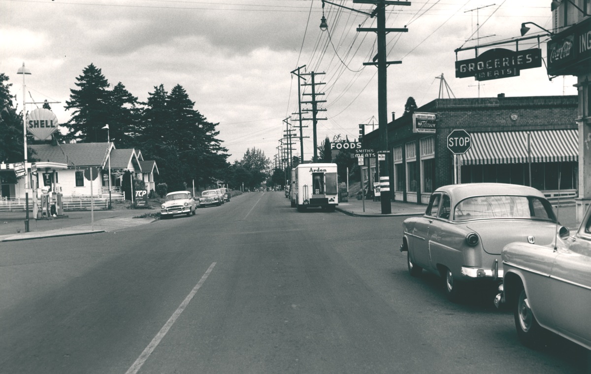
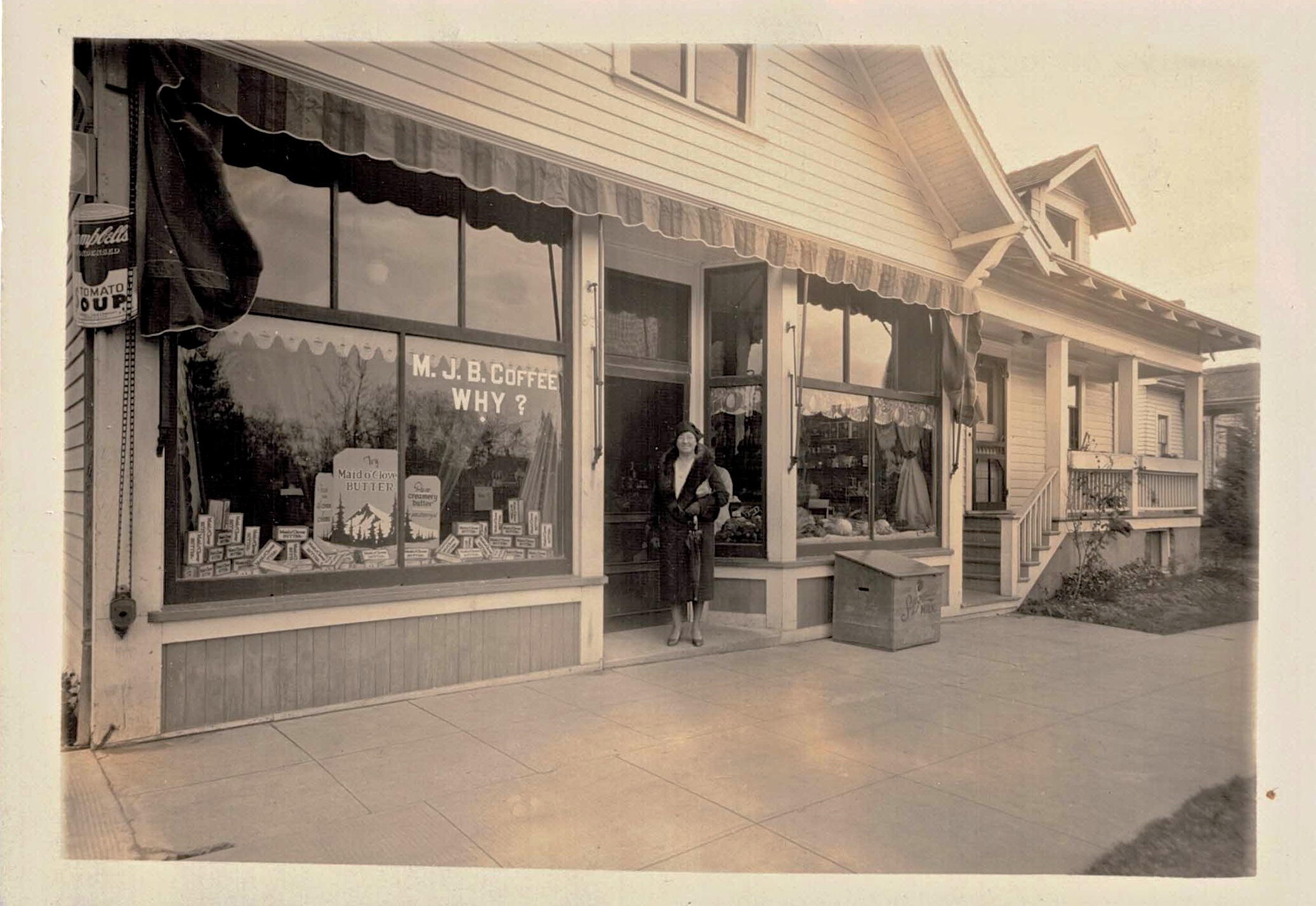
Then: Looking east on NE Killingsworth at 30th Avenue, 1954. Note stop signs faced traffic on Killingsworth. The building with the striped awning is today’s Cup and Saucer Cafe. Photo courtesy of City of Portland Archives, reference A2005-001.365.

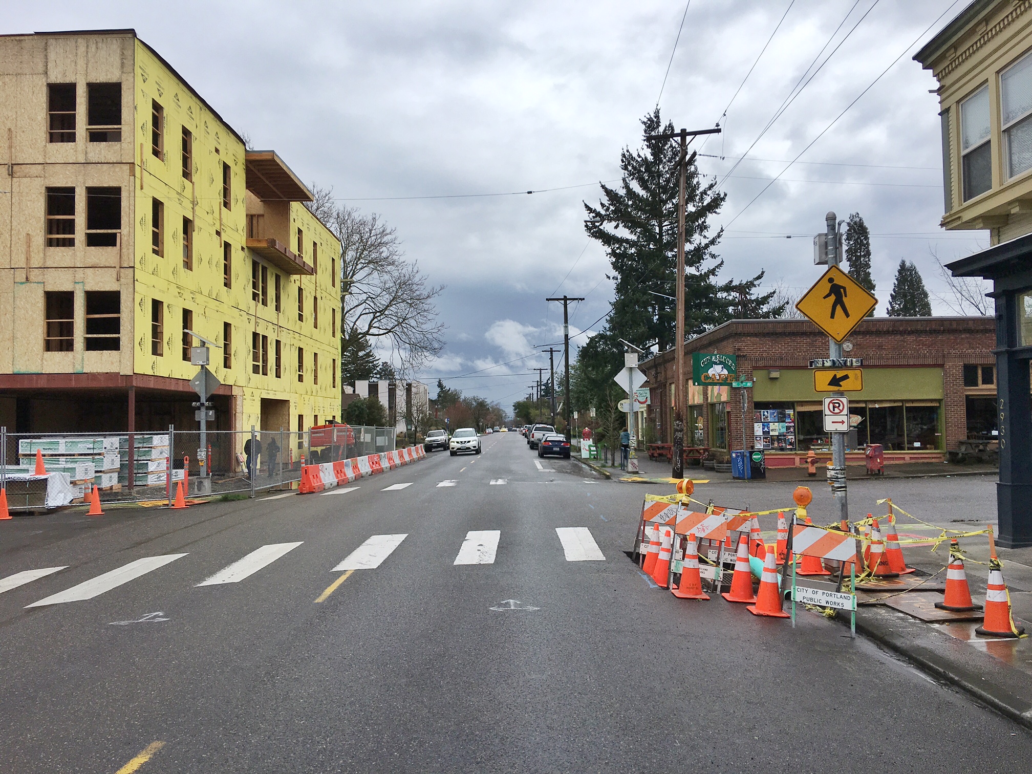
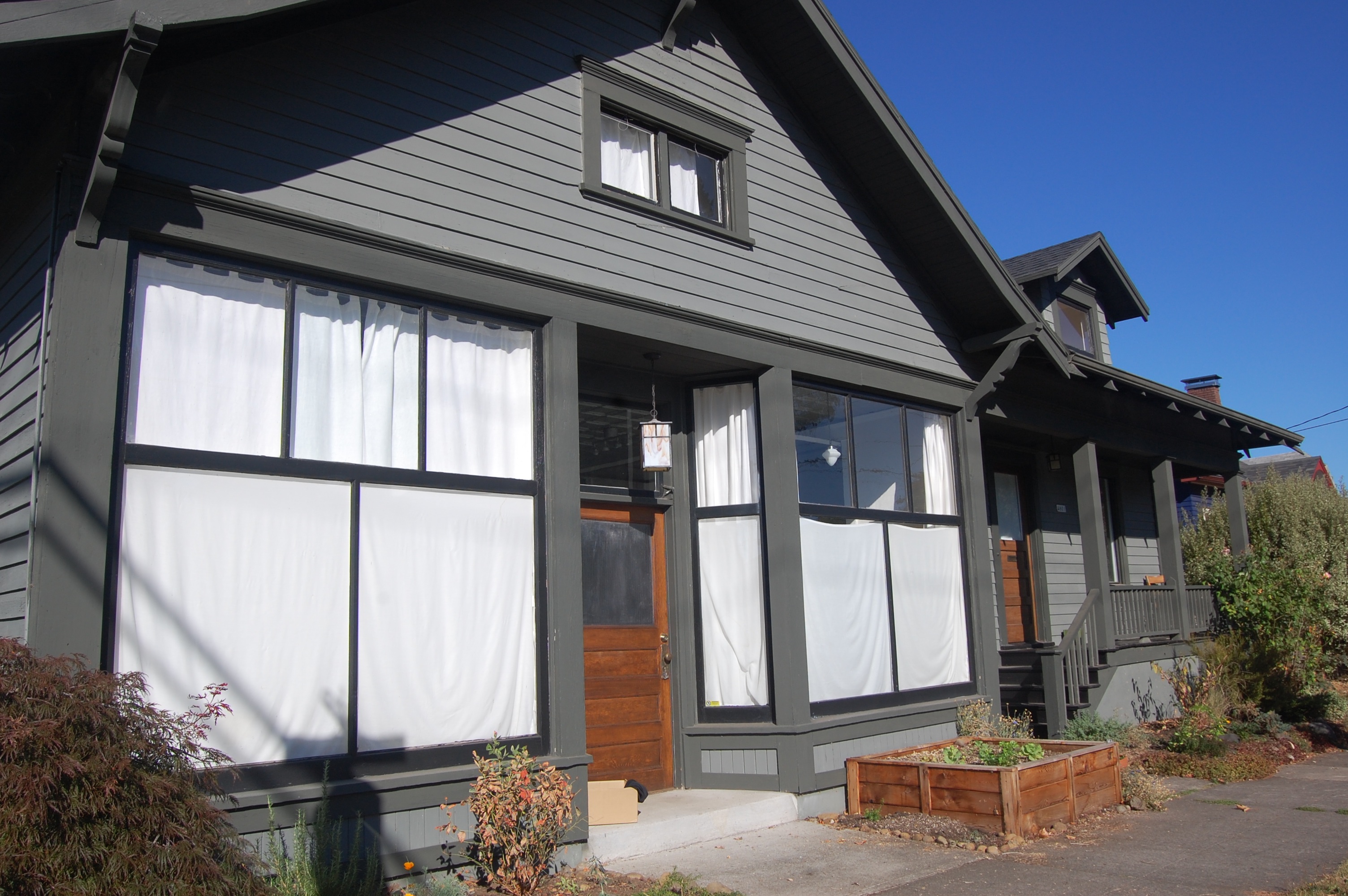
Now: NE Killingsworth and 30th Avenue looking east, March 2017. Lots of change in this photo: the Shell station on the northeast corner (which we knew for years as a U-Haul rental place) has been replaced by a type of massive apartment block that has become ubiquitous on Portland’s eastside.

Here is the other then-and now pair:

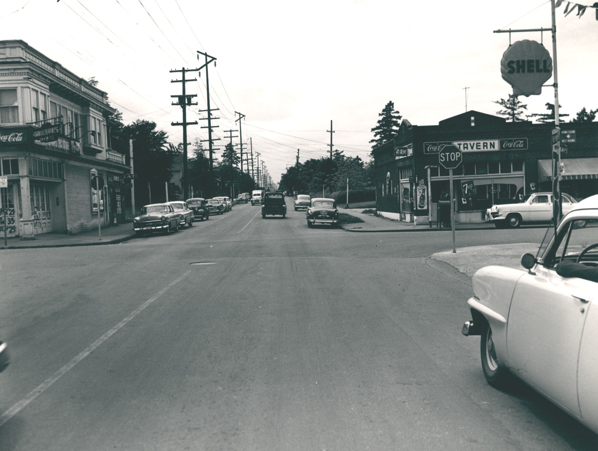
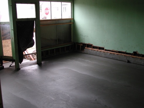
Then: Looking west on NE Killingsworth at 30th Avenue, 1954. How about that stop sign? By the time this photo was taken, the Alberta Streetcar that traveled down NE 30th Avenue to Ainsworth had been gone six years, but the “through street” mentality was still more with 30th than with Killingsworth. Photo courtesy of City of Portland Archives, reference A2005-001.366.

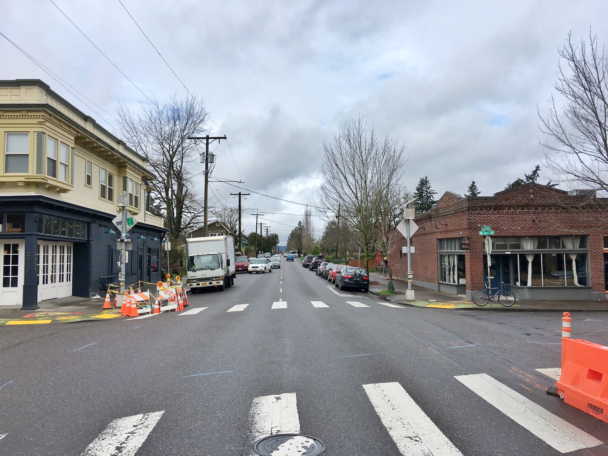
Now: NE Killingsworth and 30th Avenue looking west, March 2017

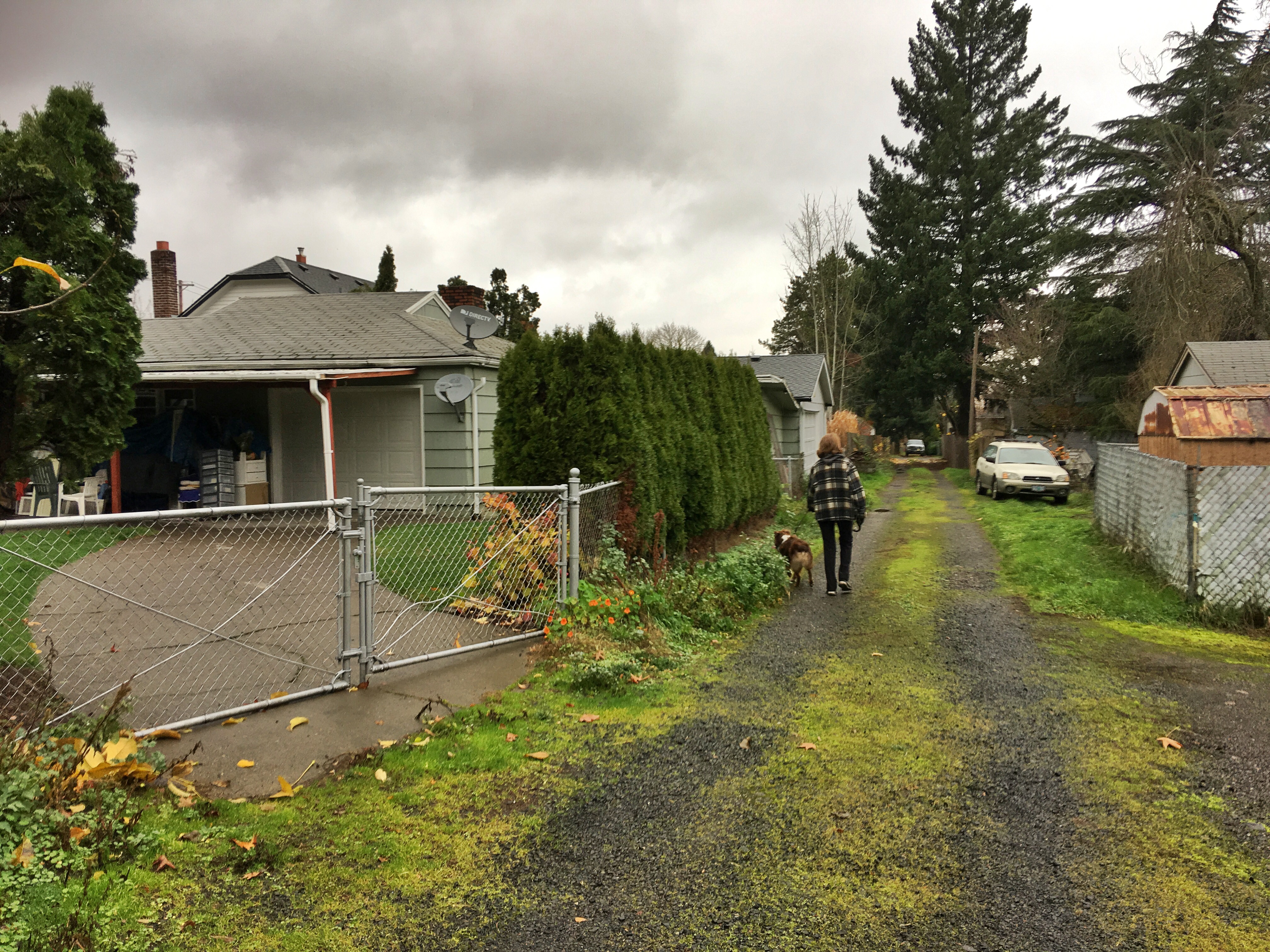
An unscientific survey taken on a Friday morning walk with the dog turned up the fact that most local business owners at the increasingly busy intersection of NE 30th Avenue and Killingsworth know they are in Foxchase. There are some Airbnb’s in the area identifying themselves as being in “Fox Chase.” And maybe a few residents who think of themselves as Foxchasers too. But chances are if you tell a friend “I’ll meet you in Foxchase for a beer,” they’re going to need directions.

So when we came across the 1954 photos recently and were already doing some serious digging into how the Foxchase plat came to be—and it is a fascinating story—we thought it was time to set the record straight with a little history.

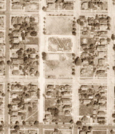
First of all, it’s Foxchase. That’s what the plat says, filed on April 1, 1889 by Eugenie M. and J. Carroll McCaffrey. Here it is:

Foxchase Detail 1889

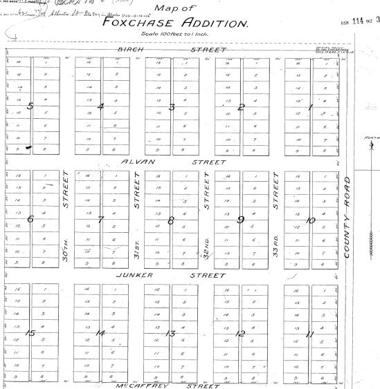
Only the numbered streets retain their identity today. McCaffrey = Alberta. Junker = Sumner. Alvan = Emerson. Birch = Killingsworth. The intersection of NE 30th and Killingsworth anchors the northwest corner.

The 1889 Foxchase plat was actually filed in the town of East Portland. At that point we were a separate city distinct from Portland, as was Albina and several other outlying communities. In 1891—in an attempt to roll together the greater Portland area population into one number that would keep us ahead of Seattle—the three towns consolidated to became one (46,385 people in Portland + 10,000 people in East Portland + 5,000 people in Albina = 61,385 people total in the Portland “metropolitan” area). Take that, Seattle (total 1890 population: 42,837).

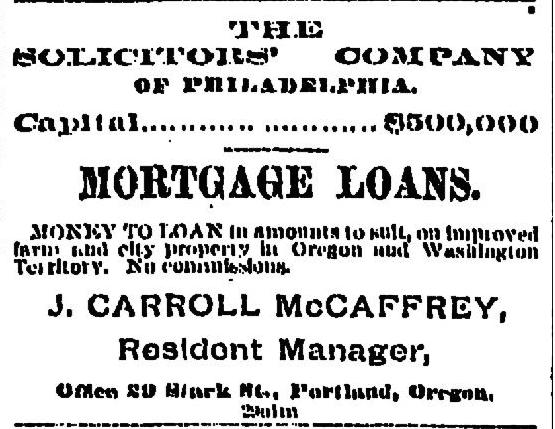
Not long after platting the property, J. Carroll McCaffrey started running classified ads in The Oregonian and the land speculation boom was on.

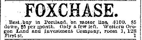
From The Oregonian, February 19, 1890. McCaffrey set up the Western Oregon Land and Investment Company for his real estate deals.

Dozens of Foxchase real estate transactions show up in the early 1890s. All speculation: the buying and selling of lots.

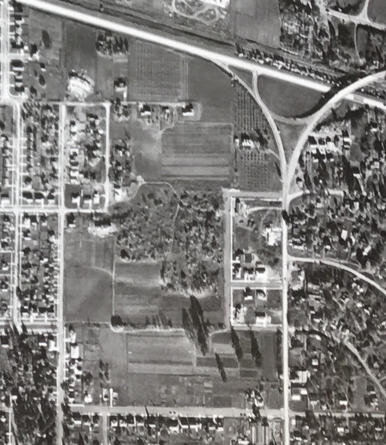
At that point in our history, there wasn’t much up here on these gentle slopes of the Columbia Slough and the Columbia River beyond. Fields, forests, a few dairies here and there; Homestead Act claims from the 1860s held by a couple dozen families. Alberta was a dirt track meandering 10 blocks between MLK (Union Avenue then) and what is today’s NE 15th Avenue. Across the Willamette River, the small grid of what we think of as downtown Portland was getting ready to explode, and investors like McCaffrey knew it. His business was to use other people’s money to buy up open land for the eventual grids of streets and lots that would follow.

Here’s where the story gets interesting.

J. Carroll McCaffrey was a Georgetown-educated attorney, born and raised in Philadelphia, who kept a small practice there as well as here in Portland. He and his wife Eugenie were busy on the social scene of both communities and frequent travelers back and forth.

They showed up in Portland about 1886 and McCaffrey quickly became ingratiated with Portland business leaders as a likeable and cheerful person. That fall and through the winter of 1887, J.C. placed the same advertisement in The Oregonian almost every single day:

McCaffrey found what he was looking for and was quickly engaged in the development of Portland Heights (southwest Portland), being quoted in the newspaper about the availability and quality of artesian well water in the southwest hills, helping incorporate the Portland Cable Railway Co. to transport people up to the heights, and building a prominent mansion known today as the Markle House to entice development.

At the same time as he was speculating on property in the southwest hills, McCaffrey looked to the east side guessing Portland was headed that direction too. He acquired a majority interest in a 15-square block portion of what was the larger 160-acre Donation Land Claim of George Emerson. He and Eugenie platted these 15 blocks as Foxchase.

Here’s where the Philadelphia connection comes in. Fox Chase is the name of a comfortable neighborhood in northeast Philadelphia, named for an 18th century inn. During McCaffrey’s timeframe of reference—the 1870s-1880s—Philadelphia’s rich and famous were building their mansions in Fox Chase. He and Eugenie were trying to call that to mind.

Their choice of street names hit close to home too: Because Alberta didn’t exist except in the Albina area, they planned for that main street on the south end of the plat to be McCaffrey Street. Junker, the next street to the north, was Eugenie’s maiden name. Was Alvan the nick name for one of their four young children? And Birch? Hmm, no birch in that area. Choose any nice tree name.

McCaffrey liked what he saw in the land speculation business, and in 1890 incorporated as the Western Oregon Land and Investment Company (that’s his company in the 1890 classified ad up above). He was just getting rolling.

But not long after that, things started to fall apart. McCaffrey unsuccessfully sued his former partners in the southwest Portland cable railway enterprise and George Markle, who bought the mansion McCaffrey had built on Portland Heights. In 1892 McCaffrey was arrested for land fraud related to 80 acres he was trying to sell south of Oregon City, charges he wriggled out of on a technicality. In 1893 he was charged with embezzlement, which he tried to shrug off as a misunderstanding and escaped because of technicality related to evidence. That same year he was accused of fraud by two of his fellow members of the Chamber of Commerce. And, Eugenie was granted a divorce citing inhuman treatment.

When he was indicted on check fraud in February 1894, The Oregonian reported that in a period of a few years, McCaffrey had been remanded to a grand jury on a dozen fraud charges of various types. He was no longer able to secure a bondsman to keep him out of trouble, and business must have gotten tight as people discovered he was not a man of his word. Eventually, McCaffrey was convicted of check fraud and served a few months in the Oregon pen before winning on appeal on a technicality, when he fled to his native Philadelphia to resume his legal practice.

Here’s where it gets stranger than fiction (a small reward for those of you who have stayed with me this far): In 1895, McCaffrey was hired by the defense team of serial murderer H.H. Holmes (made famous in the book The Devil in the White City…about the “murder castle” near the 1893 Chicago World Fair) to try to persuade Pennsylvania Governor Robert Pattison and the Pardon Board to stay Holmes’s execution. We know McCaffrey was a persuasive attorney when it came to appeals, but not this time. Several months later, McCaffrey took his own life.

So, it’s probably OK McCaffrey Street never made it to the map. And interesting that Foxchase is making a comeback, though some still think of it as the northern part of Concordia.

We’ve written here before about the distinction between subdivision or plat names and neighborhood names. Most plat names have disappeared into the fog of the past, no longer used or even known by neighbors who occupy them every day. Plat names were provided by developers when they extended their portions of the grid into the fields and forests that were here before us. Just like the McCaffreys did, developers tended to choose plat names that sounded attractive or that called to mind the suggestion or essence of a special place.

Some of our favorites that exist invisibly under our feet here in northeast Portland today are Manitou, Railroad Heights, Spring Valley Addition, Town of Wayne, Durant’s Nightmare (yes, that’s a real plat name…referring to the nightmare the surveyor had in getting all the survey lines to meet up).

Long live Foxchase.

Part 3: Alberta Bungalow Grocery Restored

Third of three parts: Bringing a great old building back from the brink

store (corner view) (1)

In 2002, with much of its south-side clapboard replaced with T-111 siding, a clear southward slump, rotted floors, and replacement aluminum sliding windows, the bungalow-grocery at NE 27th and Going was crumbling and weeks away from being torn down. Photo courtesy of Chad Crouch.

It’s been a while—regrettably, a very busy spring—but just to refresh from Part 1: In 1910, the neighborhoods around the busy young Alberta Street were at the edge of a very fast-growing Portland. As real estate values and more people caught up with the region north of Prescott and south of Killingsworth, a booming residential and retail area began to grow.

One particular building at the northwest corner of NE 27th and Going merged both residential and retail. In Part 2, we covered how the modest bungalow storefront opened originally as a men’s furnishings store, and was adapted over time and changed hands through the generations, closely integrated with neighborhood life until it went out of retail use in the mid 1960s.

Deferred maintenance began to catch up with the building, and when it was sold to a developer in 2002, the property was well on its way to becoming a vacant lot. Fortunately for the building, an adventurous fixer-upper couple named Chad Crouch and Sheryl Eckrich bought it four months later and began to bring it back to life.

porch exterior-untouched

Missing siding, aluminum sliders and a rotting back porch were the least of the worries. Photo courtesy of Chad Crouch.

“I was attracted to its unusual live-work facade which I thought was very handsome, unique, and proportionally graceful,” remembers Crouch. But he also remembers that it was in very sorry shape. The southeast corner was rotted and sinking. The foundation and the floor of the store had to be completely replaced. The residential kitchen was a disaster.


kitchen untouched

The worn-out kitchen in the residence area, looking out the back door toward the porch. Photo courtesy of Chad Crouch.

While it had been almost 40 years since being an active retail store, Crouch and Eckrich found two clues, including a Franz Bread ad and the word “LIPTON’s” etched into window glass. Other than that, the store space held no clues to generations of retail activity. “It was very spare: plaster walls and painted wood floors.  Florescent shop lighting.  No original fixtures, stencilling, or noteworthy mouldings. There was a wood stove taking up a lot of floor space.”


new concrete floor

Inside the store space looking toward the front windows. Note the new foundation wall on the right (the building had to be lifted by jacks and the new foundation poured underneath). The new floor shown here is a poured concrete slab piped with warm water to keep the floor toasty during the winter. Photo courtesy of Chad Crouch.


guest room walls stripped (1)

One of the few clues to the building’s earlier retail life. An advertisement for Franz bread. Photo courtesy of Chad Crouch.


Crouch and Eckrich invested sweat equity and financial capital in the restoration, and did so in a creative way. “We used some of the original wood flooring in a step-up elevated dining platform and perimeter bench in the main room.  It turned out to be more work than it was probably worth, as the planks had been compressed by traffic patterns of 100 yeas of foot traffic. Some hand planing was required to work out the refinishing.  We put up salvaged tin ceiling tiles on the new span joists we ran to accommodate a master bedroom in the 1/2 story above.”


DSC00962

A view of the finished store space (front doors and windows are on the left). Note the fireplace, salvaged ceiling tiles, new hydronic slab, and built-in perimeter bench in the former store space. Photo courtesy of Chad Crouch.


A gallery of photos was posted on a real estate website when the building was sold in November 2013, so click around and take a look. Chad and Sheryl have done a great service to the future and to the past with their careful, thoughtful restoration. The Smythes, the Coulters and the other proprietors–plus the generations of families and neighbors who bought their groceries and necessities here–would definitely recognize the building and think it’s in fine shape for being 105 years old.

Today, Alberta’s bungalow-grocery is an attractive and vibrant old building that serves as a kind of time capsule for the neighborhood, showing just how nicely old buildings can be restored and repurposed instead of razed and replaced. In a neighborhood where change is the common denominator, this success story holds hope for the future.


Part 2: Alberta’s bungalow grocery

Second of Three Parts: The life and times of a neighborhood store and its people

You get the picture from Part 1: In 1910, the neighborhoods around Alberta Street feels a bit thrown together and rough-and-tumble. But investment and expansion are impressive. A strong sense of neighborhood identity is emerging (thanks in part to business booster H.D. Wagnon other early business owners, early residents and real estate developers). People are coming from near and far because property is cheaper here than in other eastside neighborhoods and there’s a new streetcar that provides dependable service.

Plus, plans underway for a new Willamette River crossing that in 1913 would become the Broadway Bridge were changing the way people thought about living and working in Portland.


Built and Run by the Smyths

Enter Michael and Mary Jane Smyth, shopkeepers from Ireland who were running a mom-and-pop grocery near 79th and Southeast Stark (then known as Baseline Road). Michael was born in Ireland in 1842 and immigrated to the US in 1864. Mary Jane was born in 1850 and arrived in the US in 1875.

By 1910, the Smyths had run several small retail shops in Portland and at least one in eastern Oregon. The couple never had children and may have seen the Alberta District investment as setting themselves up for retirement. At ages 68 and 62, they were starting their new venture at NE 27th and Going somewhat late in life.

The original plumbing permit for the building shows construction complete at the end of September 1910, three years before the curbs and sidewalks were installed by local contractor Geibisch and Joplin, and well before the streets were even paved. According to the Polk City Directory, the Smyths opened their business in 1911 as a men’s furnishings store. By 1914, the listing had changed to dry goods and the Smyths were living six doors to the north, with the residence side of the new building rented out.

Mary Jane died on October 12, 1917 and her funeral mass was held at St. Charles Catholic Church, which was then located near the corner of NE 33rd and Webster, two blocks south of today’s Concordia New Seasons (the parish church relocated to NE 42nd years later following a devastating fire and financial hardships). After Mary Jane died, Michael took a rented room in the neighborhood and continued to run the dry goods store on his own until 1921 when he sold it for $3,375. Michael died on February 20, 1922.


The Coulters Take Over: Alameda Park Grocery

William and Isabella Coulter, immigrants from England via Canada, bought the business from Michael Smyth, having seen it advertised in the March 2, 1921 edition of The Oregonian as a “very fine bungalow-grocery.” They had shopkeeping experience from several years in Missoula, Montana. It’s unclear if they gave the store its name, or if they adopted the name used by the Smyths, but there it is, listed in the 1928 Polk Directory as the Alameda Park Grocery.

This is unusual for a couple reasons: 27th and Going is near but not actually inside the Alameda Park plat; and, there was a much more prominent store on the southwest corner of 24th and Fremont known as the Alameda Grocery. This must have been confusing, at least. No word about what that rivalry may have been like, but the 24th and Fremont business advertised widely with its name, and the bungalow grocery with its slight variation never shows up in any newspaper advertising or any other annual Polk Directory.

While the naming convention might have been confusing, we know it to be fact thanks to a photograph from David White, grandson of the Coulters, that clearly shows the name Alameda Grocery painted in big black letters on the side of the store. You can see the store and the letters here over the shoulder of these two best friends: William and Isabelle’s daughter Agnes is on the right and her friend Marjorie Ellis is on left. Taken about 1926, looking east on Going a few doors west of 27th. Photo courtesy of David White.

Looking south toward 27th and Going, 1926

William Coulter passed away in the mid 1920s, and Isabelle took over the business on her own, with help from daughter Agnes, until 1943. This 22-year period was probably the best era for this little building and its business: Isabelle ran a tight ship and took good care of the place.

Somewhere during the Coulter years, this incredible photo was taken, which we have paired with the same view today (spoiler alert for Part 3).

Isabelle Coulter, about 1930, 4601 NE 27th

Isabelle Coulter in front of her store, about 1930. Photo courtesy of David White. Click the photo for a larger view (there’s so much to see here you better take a closer look). Below, that same view today.

Alameda Park Grocery


From Retail to Church to Artist Studio

Charles and Vera Fiebke bought the property from Isabelle Coulter in 1943 and sold it on June 20, 1944 to Henry and Ruth Rieckers, who owned the business until 1953. During this time, the business was referred to as “Rieckers” and as “Rieckers Grocery.” A classified advertisement in The Oregonian on March 3, 1953 indicated the Rieckers were retiring and putting the business up for sale, asking $6,500.

On June 24, 1953, the property was purchased from the Rieckers by John Henry Moad and his wife Lucy Jane Moad. They operated the store—as Moad’s Grocery—until 1961 when it was sold to Robert A. and Louise M. Klatke, who changed the name to Bob’s Quik Stop Market. But not for long.

An article in The Oregonian on June 29, 1962 reports a robbery at Bob’s Quick Stop. Robert, age 56, was robbed with a knife to his throat. A few months later, he and Louise put the store back on the market, selling it to Agnes Martin on November 2, 1962. Sometime during the mid-1960s, the building ceased functioning as a store.

As we know from earlier posts here on the blog, this was the beginning of a tough time for mom and pop neighborhood grocery stores. The whole retail grocery business was changing and local grocery stores were quickly becoming convenience rather than primary shopping locations.

The Martin family owned the property for the next six years and at least one reference to the building shows it as the Mt. Zion Church of God in Christ. The Polk Directory for 1965 shows the building as vacant, and in 1967, it is listed simply as L.S. Martin. On September 17, 1968, the Martins sold the property to Carl E. Bass (son) and Viola Matheson (mother). Bass, who was a potter, turned the space into an artist’s studio and lived in the property until his death in April 2001 at the age of 73.

The property was purchased from the Bass estate by investor/developers George and Isabelle Zitcak, who held it for just four months before selling it in April 2002 to Chad Crouch and Sheryl Eckrich. This is where the story gets interesting, which will be the subject of Part 3.

To whet your appetite for the next chapter of the bungalow grocery, we’ll leave you with this photograph, which shows just how far down the building had faded during its later years and why it was a leading candidate for the wrecking ball by 2002.

2

The bungalow grocery at low ebb, about 2002. Photo courtesy of Chad Crouch.

Suffice to say that Mary Jane and Michael Smyth, and Isabelle Coulter, would probably have cried to see it in this shape.

Next up: Chad Crouch and Sheryl Eckrich bring the bungalow grocery back from the brink.


The early Alberta area and its bungalow grocery

First of three parts: Understanding the neighborhood’s early beginnings

We’ve been working on a fascinating property in the Concordia neighborhood, formally known as Lester Park (that’s not a typo, that’s an actual plat name).

It’s a store and home built by Irish immigrants and operated for several generations, eventually running out of retail energy in the 1960s when it became a church and then an artist’s studio before nearly collapsing from years of deferred maintenance and decline. We’re eager to share the fascinating story of this sweet little building—which has been lovingly restored—and an incredible photograph from the pinnacle of its retail life.

But first, we have to provide some context about the area that today might like to be known more for its hipness than the complicated polarity of change underway through gentrification, though both are present.

To be clear, the geography of the area in mind actually holds several of today’s formally named neighborhood associations: Humboldt, King, Vernon and Concordia, and the business district known as Alberta (which technically resides mostly within the Concordia neighborhood: think MLK to NE 33rd and Alberta to Killingsworth). But back in 1909, this whole area was a muddy, brushy flat that existed outside city limits and beyond what Portlanders thought of as their city.

If you lived up here in 1909, you were probably either a dairyman or the advance guard of development, and you could see the city creeping your direction. After the Lewis and Clark Exposition, Portland was booming with new residents and new construction, and hungry for relatively close-in developable land.

Here’s a hopeful word picture from H.D. Wagnon, Alberta’s number one promoter, in January 1910 that picks up the story from the perspective of a man on horseback riding through brush thickets in the area that helps provide proper context for our bungalow grocery story.

Alberta District Thrives, 1-9-1910

From The Oregonian, January 9, 1910

 If you opened up the real estate section from any Sunday edition of The Oregonian during these early days you’d find a flurry of advertisements for these desirable lots. The new streetcar provided access, the lots were affordable compared to other new subdivisions elsewhere in town, money was relatively available to loan during the rising economy of 1910, and people were flocking to the area.

Of course, this caused its own problems, documented a few months later in the June 26, 1910 edition of The Oregonian:

Alberta District Grows, 6-26-1910

From The Oregonian, June 26, 1910

 And by the end of 1910, Alberta was becoming so populated, neighbors were calling on the city to build a school.

School demanded, 12-25-1910

From The Oregonian, December 25, 1910

 The problem of education infrastructure lagging behind neighborhood development was a trend across the eastside, which was successfully raised and driven by active and engaged parents (particularly moms). One might think this equation would be clear enough for neighborhood developers (homes + kids = need for schools), but their focus was on business and the sales of lots represented profit while the construction of school buildings represented only cost. Secretary Wagnon, a promoter through-and-through still preferred to focus on the immediate positives:

“One cannot get beyond the sound of the hammer or the sight of piles of lumber in this district.”

We like that sound-picture and can absolutely imagine what it must have been like on a weekday morning, closing your eyes anywhere along Alberta and hearing hammering and construction in every direction. That little details tells its own story.

Against this backdrop of growth and growing pains, local residents started some new traditions with unintentional echoes in the life of the district today. Market fairs for produce and hand-made products were springing up mostly as a matter of necessity for local residents.

Market Opens Today, 6-20-1914

From The Oregonian, June 20, 1914

The open-air markets were a temporary fixture, but steady retail was shoring up its presence in the district. That’s where our bungalow grocery story will begin: construction of a store connected to a house at the northwest corner of NE 27th and Going, right in the heart of the construction boom.

Next up: In Part 2, 105 years ago, an older Irish couple moves to the neighborhood and opens a men’s clothing shop, which quickly becomes a neighborhood grocery.

%d bloggers like this: