We’ve been focused lately on a property in Southeast Portland’s Woodstock neighborhood, which has provided some fresh perspectives on aspects of Portland history we haven’t bumped into directly while working in the central eastside. Things like the dynamics of annexation, lots of different privately-owned infrastructure, and multiple waves of readdressing.
AH readers already know all about the major readdressing initiative in the early 1930s that literally re-made the Portland map. The Great Renumbering clarified things for most Portlanders (particularly postal employees), but not everyone was thrilled. One feature of the readdressing ordinance required all north-south streets be numbered, not named. That’s how we lost Glenn, Marguerite, Vernon and others, though the names can still be seen set into many curbs.
We’ve always been impressed with the residents of NE Vernon Avenue who continued to use the name of their street for more than a decade after the city changed it officially to NE 14th Place. Many living on that six-block stretch between Prescott and Killingsworth didn’t want to lose their local identity and continued to tell the world they lived on NE Vernon well into the 1940s. Place names are important, after all.
But we digress. Out in Woodstock, some of their streets have known three different names:
- The one that came with the plat, and in Woodstock they all had names out of Sir Walter Scott’s romance fiction set in 17th Century Oxfordshire (Waverly, Kenilworth, Ivanhoe, Everard, Wildrake);
- Those that came after Woodstock’s annexation in 1909, which randomly replaced some of the Oxfordshire repertoire and turned all the east-west streets to numbers (yes, you read that right…we’ll come back to this with a map in a moment);
- And then the ones that came along as a result of the wider readdressing wave of the early 1930s.
We were delving into a property on today’s SE Ramona, which started out as High Street on the 1889 plat, became 58th Avenue Southeast by 1915, and then became the Ramona we know in 1932.
Today, most Portlanders take their numbered north-south streets for granted and can quickly orient themselves to the Willamette knowing that on NE 24th Avenue they are 24 blocks east of the river (plus or minus).
But by 1915, all of southeast Portland’s east-west streets south of Division were assigned numbers as names and called “avenues,” counting south from Ankeny (north-south roads were called “streets”). Also of note, most of the east-west streets north of Division stuck with their names because they had an established named counterpart on the west side of the river.
So today’s SE Ramona was Fifty-eighth Avenue Southeast (that was the nomenclature, with the ordinal direction written out at the end of the phrase).
Confused?
Here, have a look at the 1915 Pittmon’s Guide map to Portland. We’ve detailed a chunk of Southeast that illustrates this east-west avenue phenomenon.
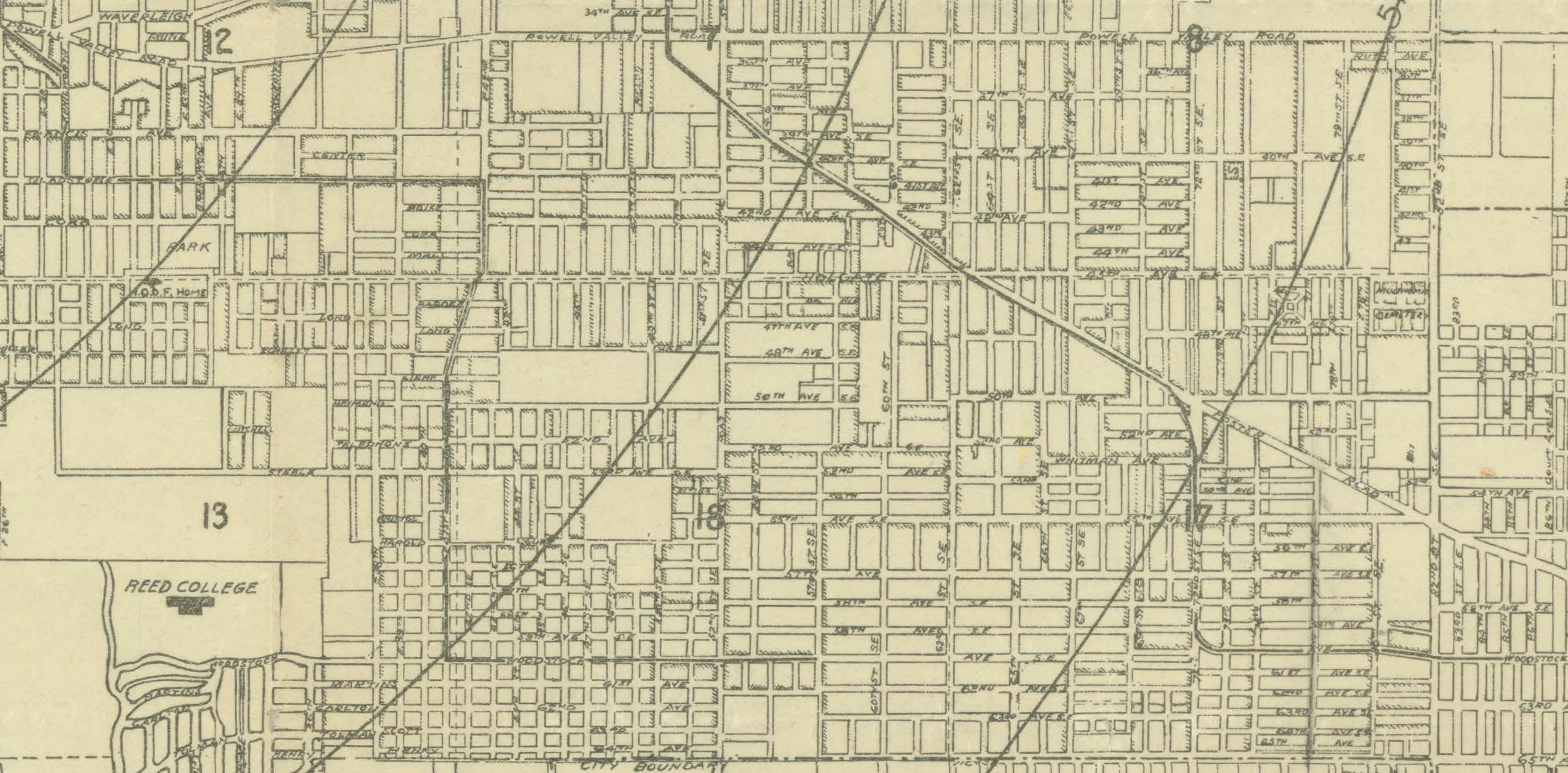
1915 Pittmon’s Guide to Portland, detail showing SE Portland from Powell Valley Road to Duke. Click to enlarge.
Just when folks were getting used to the New York-style of numbered streets and avenues, the Great Renumbering came along and put an end to all of that. Readdressing took place through several city ordinances passed over time in the early 1930s, each one cleaning up a few details missed from the last one.
Here’s a story from the Oregon Journal in 1932: take note there were 66 changes to be made in southeast Portland, but Alameda and Beaumont had some clean up to do as well. It’s an interesting idea that addressing systems could be in vogue or out of vogue.
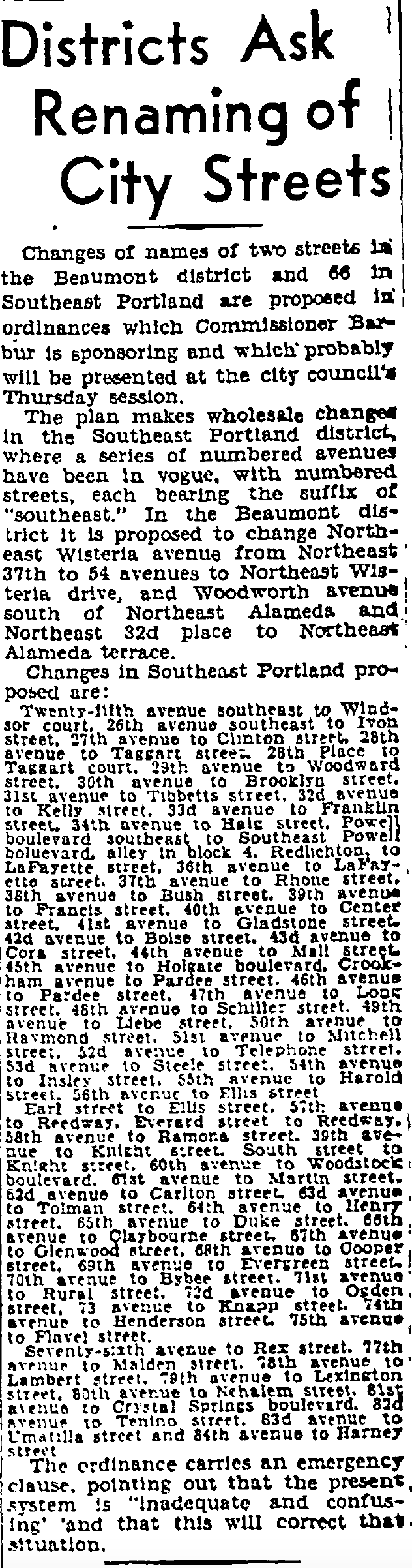
From the Daily Oregon Journal, December 11, 1932.
That’s a little piece of Portland’s addressing history we didn’t know before our deep dive in the southeast: east-west avenues with the directional at the end of the address once gridded that part of town.
We’ll save other insights for future posts:
How before annexation a myriad of privately-owned water systems were elbowing each other for business and access to Bull Run water (Woodstock was on a private well for many years).
Same for Portland’s streetcar system, which really wasn’t a single system but a collection of competing fiefdoms for many years until consolidation began in 1904.
And annexation, those neighborhood politics were as polarized as possible: some public meetings devolved into shouting matches, the rhetoric related to taxes and the role of government. In Woodstock, even after the November 1908 61-percent victory for annexation, the anti-annexers challenged the vote all the way to the Oregon Supreme Court where it was affirmed and Woodstock became part of Portland on July 1, 1909.
2-13-2021 Post Script: We’ve posted a link to the full 1915 Pittmon map, which is now on our Maps page. Embedded in that map is a statement that highlights the challenges presented by the pre-1930s address system. This official map advice relates to getting around in North Portland:
Extreme care must be exercised in this district as the streets having E. and W. prefixes are more nearly north and south. While streets having “N” and “S” prefixes are more nearly east and west.
Nearly funny if it wasn’t absolutely true.

