Every now and then in my research, I’ll find something—a memory, photograph, map or document—that really sticks with me and defines the way I think about a place.
This month I found a batch of mis-identified photographs when searching at City of Portland Archives that resulted in an absolute jackpot from 1913, opening a fresh window into the past near NE 33rd and Fremont.
Once known as Gravelly Hill, the area was indeed a gravel pit for many years in the late 1800s, and later the repository for all of the eastside’s household garbage between 1923-1924, then known as the Fremont Sanitary Landfill.
But before the landfill, back in 1910 as subdivisions crowded in around the big pit, questions were raised about the basic stability of Fremont Street, which was just below the brow of the Alameda ridge and ran right along the north edge of the pit. Developer Benjamin Lombard, who platted the adjacent Olmsted Park about that time, even sued the city for violating its own ordinance about gravel pits.
So, no secret: that slope South of Fremont was a gravel pit.
But as it turns out, it wasn’t just a gravel pit. It was a GIANT gravel pit. See for yourself:
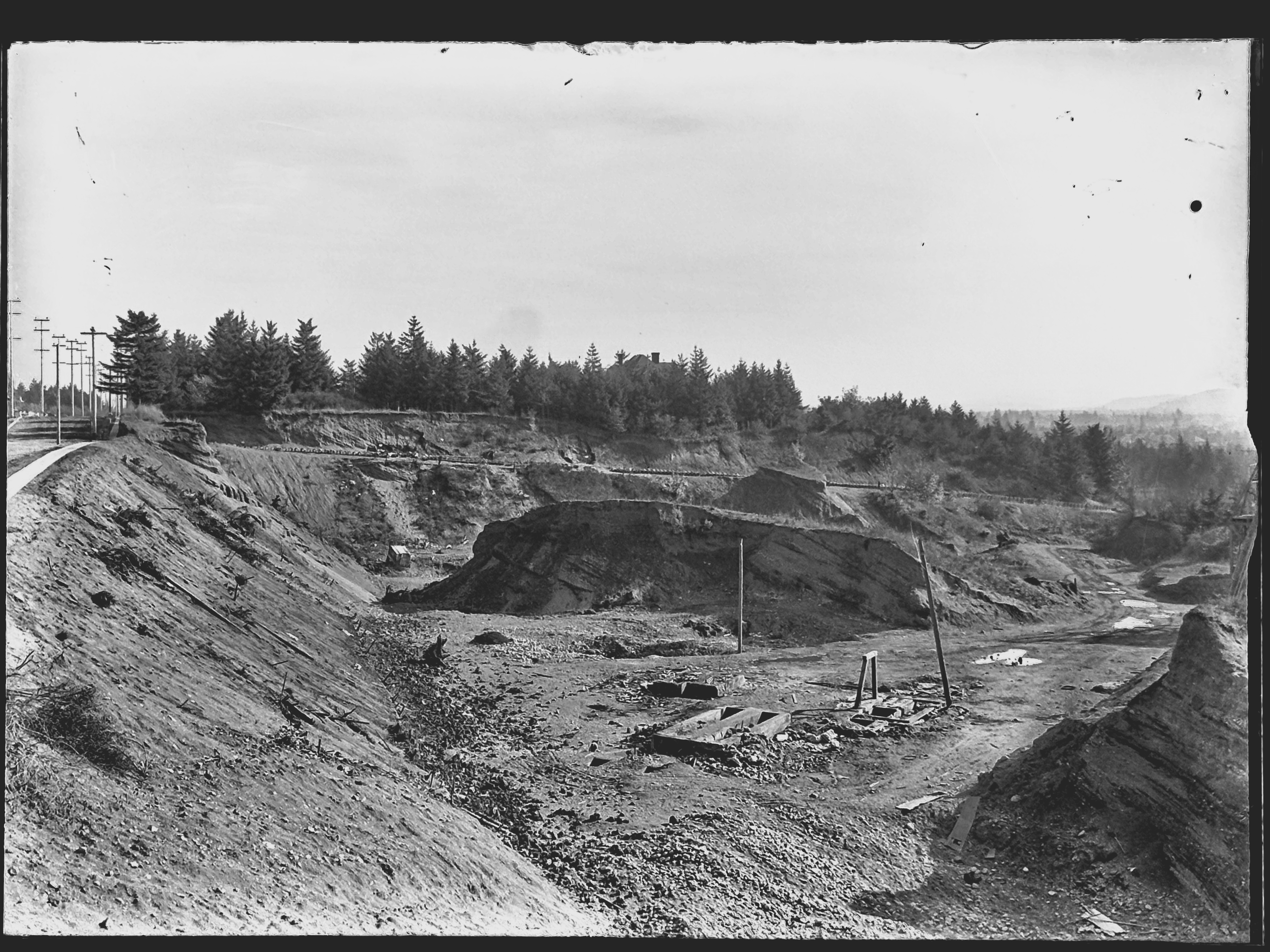
In 1913, a photographer for the Department of Public Works visited the pit and brought back 11 amazing images that got buried in the archives. They’re large-format glass plate negatives, not prints, and for years have been filed away in envelopes under “Lombard Street” at City Archives. I suspect few people have ever seen them. A few weeks back, something else I was looking for led me to these glass negatives.
I photographed each plate and made positive prints to be able to better visualize the scenes. And as I studied that first picture and figured out it wasn’t showing Lombard Street, but Fremont Street, I knew this would be a find to remember.
After that first photo, there were these next two, clearly taken as a pair, to illustrate the depth and breadth of the pit. Both are unquestionably tied to the Gravelly Hill landscape. Here I’ve melded them together to create a single image:
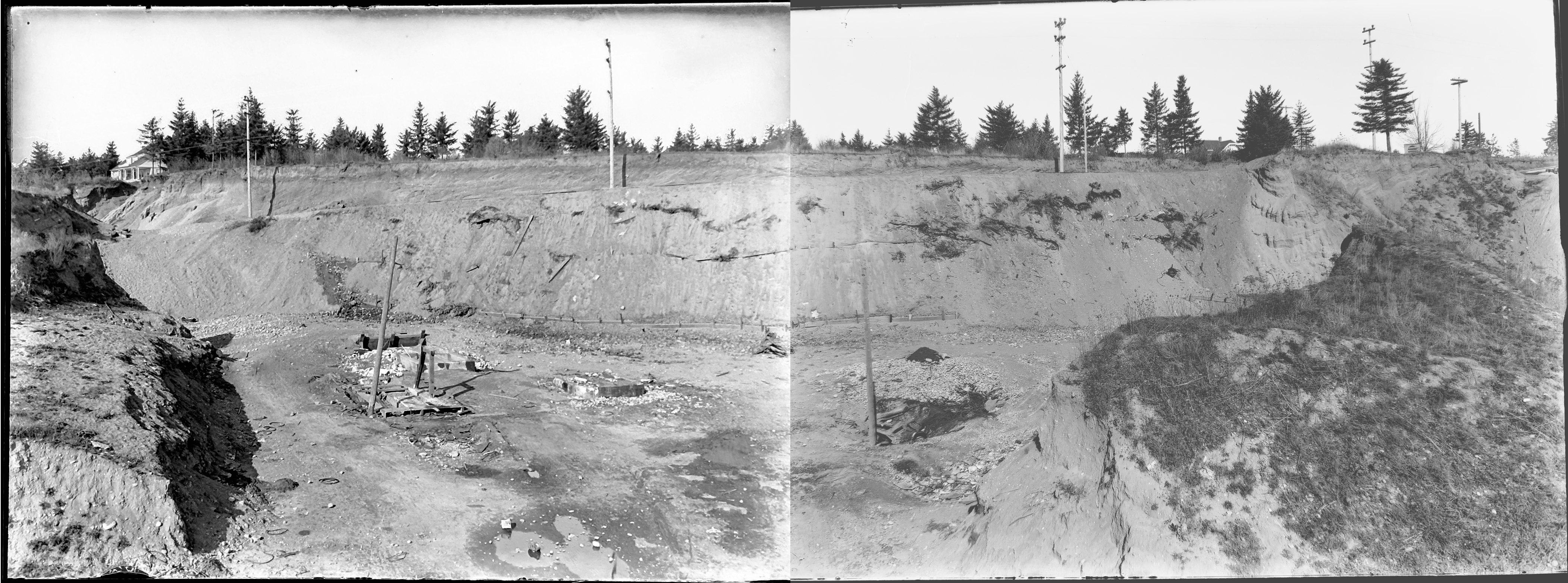
Looking north into the gravel pit at NE 33rd and Fremont, December 1913. Click to enlarge. View would be from between today’s Siskiyou and Klickitat streets, looking uphill. The house at far left is today’s 3251 NE Alameda Terrace. The house at far right is the top of today’s 3305 NE Alameda. A sign is visible at upper right for a new subdivision, placed in the cutbank on the northeast corner of 33rd and Fremont. Segments of sewer pipe are visible stacked there. Today, the pit is filled with three city blocks and more than 50 homes. City archives photos, left: A2009.009.3619; right: A2009.009.3620.
Here’s a bit more context from neighborhood historian R.A. Paulson, writing in The Community Press on October 1, 1975:
“From the earliest recollections of those familiar with the area, this was a worked out gravel pit, the excavation of which had been finished many years before but still showing the signs of one-time activity. As late as 1919 and 1920, the pit formed a precipice going down sharply from near Fremont possibly 100 feet or so to the level of Klickitat and extending between 32nd place and 33rd Ave. Coming from the west, Kllickitat Street was unpaved east of about 29th with the cement sidewalks ending there but even between 26th and 29th these sidewalks were impassable because of the overgrown bushes and small trees.
“The gravel pit had been a lush source of rock and gravel for someone way back and the solid bank of this material had originally sloped down from Fremont at the same grade as the present 33rd Ave. This had been scooped out over a period of perhaps 50 years or more and most likely went into improving the lanes, roadways and public highways for miles around, certainly for the country roads that became 33rd Ave. and Fremont Street.
“The bed of the pit showed evidence that work and even habitation had gone on there but at the time of World War 1, only a monolith of stone, too difficult to remove with pick and shovel, reared upward from the new level.”
Here’s a detail from a 1925 aerial photo that shows the extent of the pit and the still-forming street infrastructure. The pit covered two-plus blocks, from NE 33rd to NE 31st, between Fremont and Klickitat.
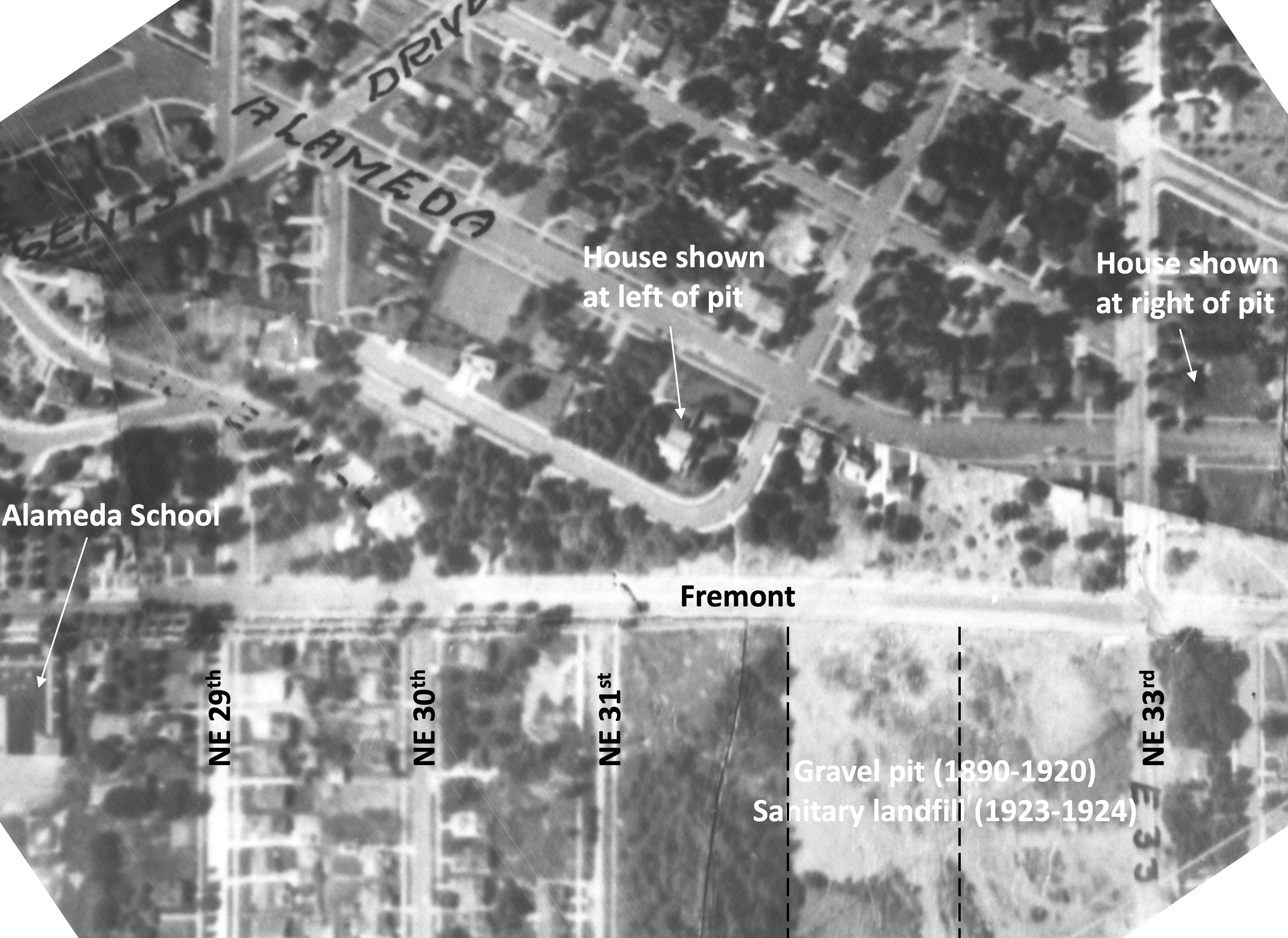
Detail from a 1925 aerial photo showing the intersection of Fremont and 33rd, labels added for reference. Dashed lines indicate eventual location of NE 32nd Place and NE 32nd Avenue. Click to enlarge. Aerial photo courtesy of City of Portland Archives.
Stay tuned for eight other gems in this collection that are just as knock-your-socks-off amazing as these three. Next up: we’ll take a close look at the intersection of NE 33rd and Fremont 111 years ago, absolutely recognizable to today’s eye.


Hi, I have enjoyed all the articles I have read about the NE section of Portland OR. My parents bought a house at 2415 NE 41st, Portland OR 97212 in 1967. My family lived in this home for almost 55 years. My parents raised me and 2 brothers in this house. We all have wonderful memories of growing up in the Hollywood area!! I am wondering if you have any articles about the Hollywood area. I also would love to do research on the family home on 41st. I just had to sell the home a couple years ago after my mother passed away. Thank you very much for any information you may have or any advice on how to explore info on this home! Thank you, Lisa Keeran, 503 298 0958
Great work this created great sledding on 32nd hill when I was a kid in the mid 50s,also in that same period I was well aware of the mansion at 35 th and Klickitat as it was known then and it’s occupants Mr Illege who had married into the Barnes family and was an elderly widower..I met him after myself and 3 of my pals had aged along with one of the kids older brother and his friends when they vandalized the items on the screen porch,when my mom found out what had happened she sent me to apologize to him.I took a bucket of cherries off one of our trees and went to make my apologies,he was a gracious man inviyme in and walked me through the first floor where all the furniture was covered with sheets,we walked up the stairs to the third floor to the ballroom where he described the great parties that they had when his wife was alive I went with him out the back of the house to the carriage house which was ne of the house where he showed me the pre 1920 Cadillac touring car,he invited me back to pick some apples from his trees when they were ripe which I did.After he died the property was sold to Dean Hutchins who was a nationally know organist who had just become the organist at the First Congregational church in downtown where my mom had started as the ministers secretary and had become the business manager.Dean did a major update to the house and installed the massive pipe organ.My wife and I accompanied my Mom to Deans open house and concert when it was completed.The pipe organ and haunted house were part of a novel written by Beverly Clearly whose Mom lived across the street from us on 37th I am also aware of the city doing a big repair project on th SE corner of 33 and Fremont around 1960 must have been working on the old line buried there That whole area has so much history I love what you have found.Another strange thing I am aware of is tracks in the street west on Stanton from 36th around the corner from our house
What great stories! Thank you for sharing.
Thanks, Doug! What a fantastic find. We’ve lived near the south end of the pit for 39 years, and I had no idea it was this expansive.
This is so cool to see! My parents moved us back into the neighborhood in 1982 (I was in the second grade) on 32nd Ave between Klickitat and Fremont, and are still there today.
This was an unbelievable find. We lived at 3427 NE 32 Place from 19980 to 1988 and everytime I worked in my front yard, I would find pieces of china or glass and wondered why..now I know. Thank you so much for this find!
Thanks Bev. Wait til you see the others!
Do you have any of the house on ## & Fremont that was the Yaws house? I remember the roof tilting quite a bit from settling and the house directly south of it on 33 had a lot of settling problems!
Is this the house you are thinking of: https://alamedahistory.org/2019/01/27/rest-of-the-story-the-lost-house-at-33rd-and-fremont/
Yes..that is the one and I loved the info from Judy and Barbara! When I lived just over on 32 place..we had lots of cracks in our walls from settling issues and of course the finds in the yard of broken dishes!….great to look back on this history!
I would love to know Judy’s maiden name since she lived in Laurelhurst..maybe went to school there? I atttended laurelhurst school until grad in 1959 and then on to Grant High. We lived on Davis Street and then on Royal Court.
Thanks again!
The pictures are a fascinating find, particularly to someone living on 32nd Ave just south of Knott. If I wake to stray houses on the front lawn, I’ll know why. Thank you.
Great detective work! We enjoy your results for a good look back in time. Thank you.
What a great find. It’d funny what you run a cross when you’re looking for something else.
Thanks, Doug. Fantastic discovery, especially with the clarity and precision as you present it. My understanding is that several decades ago residents in the area had land settling problems they had to remedy. By the way, it’s interesting that just a few blocks south on 33rd was the Versteeg Brick Yard where Grant High and the park now stand. The deep red remains were unearthed when the athletic fields were renovated a few years ago. Dutch immigrant Emerinus Versteeg himself lived in a large house (now long-gone) on 33rd across from his brick works. 33rd, of course, was a county road and main thoroughfare connecting to the farmland to the north near the Columbia River.
Super sleuthing, Doug! So the north side of Fremont has a natural profile. The south side has been filled to create an even slope. Am I correct? Is any part of NE 33rd, south of Fremont, visible in the photo or was it created as part of the fill? Do you know if the landfill rubbish was removed or just covered over?
Thanks Susan. These are some amazing photos, tack sharp and large format glass.
Yes, above the slope is on the flat. The entire ridgeline–from near 13th and Prescott all the way east to Rocky Butte, which today we think of as the Alameda Ridge–was known as Gravel Hill and Gravelly Hill, and this area at 33rd and Fremont may have spawned that name (it is an old pit, going back to the 1870s). In the single photo, the profile of the cutbank, which is just east of 33rd, mirrors the profile of the original slope, which was significantly scooped out well below the natural slope grade. The profile of the slope was refilled with garbage and soil during the 1920s, particularly during the era of the Fremont Sanitary Landfill (1923-1924). The process was to dump trash over the edge downslope from Fremont, mix it with soil, and grade and re-grade it with tractors as the pit filled. All evidence I have seen suggests the landfill material and soil were left in place and capped with additional fill to make the slope we see today.
Excellent detective work, ‘Inspector’ Decker! The photos also provide a window into the Missoula Flood deposits.
I wonder how that slope will hold up during the next Cascadia earthquake.
My great- great Grandparents were the Barnes.
I always enjoy seeing pictures of what was near the house and hear the memories people have from that area.
Thank you so much for this research and amazing pictures! I had no idea about this areas past! I have ancestors buried in this cemetery and my great-great-grandparents were The Barnes!
Seems maybe some semi-attentive city clerk saw Alameda Developer ‘Benjamin Lombard’…so dutifully filed the pictures under Lombard Street. Not only a good find, Doug…but that you recognized those craggy mounds of earth as OUR landscape…Wow!
Great catch, Doug! Thanks for sharing this bit of history with us. So cool!
Great picture. I knew an older man in the 1990s who grew up in the neighborhood. He knew all about the gravel pit and then the dump. When he was a boy he and his friends regularly went to the dump to shoot rats with their .22’s. I’m guessing late 1920’s
I’ve had another person tell me there was a narrow gauge railroad running along the ridge. Maybe it was for the gravel pit? I’ve never been able to find a record of it.