Figuring out the Prescott Jog

AH readers know we like nothing better than a good history mystery, so we were intrigued when a reader asked recently about why NE Prescott makes a jog south between NE 33rd and NE 37th. In this case there is no one single reason: it’s multiple reasons related to changes in surveying proficiency, the passage of time, the helter-skelter nature of developers operating at the edge of the city limits in 1900, and a complete absence of planning in our turn-of-the-last-century city.

The Prescott Jog near 37th

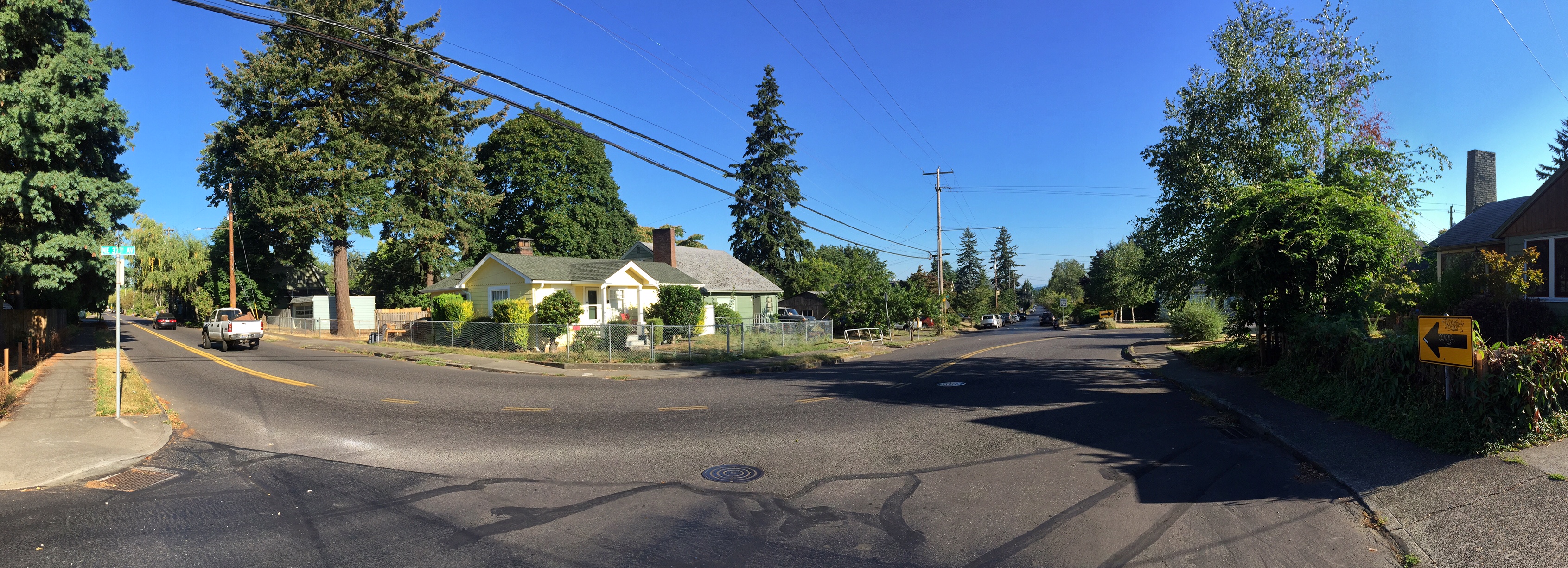
The jog at NE Prescott and 37th

Let’s look at the basic ingredients:

The Grid: Back in 1850, surveyors used a grid to map Oregon and to organize our landscape into big boxes and small boxes, known as townships, ranges and sections. In Northeast Portland, our main east-west streets are organized on section or half-section lines. Prescott (all but the four-block stretch we’re talking about here) rests on a half section line.

The Plats: Portland has more than 900 of these: a plat is basically a plan that divides the land into lots and streets. Developers were in charge of their own plats, and gave them unique names, some of which are pretty interesting. A plat called “Willamette Addition,” drawn and filed in 1888, contains the area from Skidmore to Killingsworth and from NE 33rd to NE 37th. Of particular note: running along the bottom of that plat is our mystery stretch of Prescott between 33rd and 37th.

So here’s what happened:

The Willamette Addition was anchored on the south boundary to what in 1888 was thought to be the half-section line (the future Prescott). Actual development of the Willamette Addition didn’t happen until the 1920s, and in many cases much later.

Our maps pages shows both Alameda Park (the neighboring plat to the west, 1909) and Wilshire (the neighboring plat to the east, 1921), which were laid out decades later by different developers using different survey technology. And guess what: the location of the real Prescott (in alignment with the more-recently-surveyed half-section line) moved about 75 feet to the north.

But meanwhile the Willamette Addition was still just a drawing and raw land owned by different developers, with it’s weirdly offset four-block southern boundary, which was referred to as Columbia Street, stuck on the grid of 1888 and quickly becoming irrelevant. The developers of Alameda and Wilshire weren’t in control of the Willamette Addition, but they had to build streets around it and needed to tie their new neighborhoods into the actual half-section-line-based street we know today as Prescott. So, build they did, marooning this yet-to-be developed four-block stretch of “Columbia Street” 75 feet to the south, and necessitating eventual construction of the s-curve jogs we know today when development of the Willamette Addition finally followed years later.

There’s a story behind everything. That’s why we love history!

Then and Now | “Dad & Lois” Long Ago

AH reader and fellow old-picture lover Chris Wilson has shared this photograph, found last year at a yard sale near Rocky Butte. Click on it for a close-up look. Lot’s of detail, including the original pre-address change address of 605 (on the column above the dad’s head).

2835 NE 55th

Our only clue: written on the back is “Dad & Lois at home place.” We love mysteries like this. With a little digging we’ve found this house in the Rose City Park neighborhood (not too far from Archbishop Howard School) known today as 2835 NE 55th Avenue. This stately Portland four-square was built in 1910. Apparently, Chris Wilson may have offered it to the current homeowners, who reportedly weren’t interested. So he wrote us, knowing that we love photos of old houses (especially with people in them), and that we love to solve old house and old picture mysteries.

Here it is today:

2835 NE 55th Today

After looking back at building permits, census records and a little deductive reasoning, our hunch is that this is Christopher J. (Dad) and Lois Schmiedeskamp. In the teens and early 1920s, the family owned and operated a grocery store and meat market at 7224 NE Sandy Blvd., right next to Fairley’s Pharmacy (home today to Berni’s Beauty Salon). Later, CJ went into real estate and mortgage banking.

Also at home around the time of the old photo were mom Mildred, brothers Charles and Karl, and sister Edith.

A quick look at the phone book today suggests the Schmiedeskamps are still in Portland. We’re guessing they could be interested in seeing this yard-sale-salvaged photo of their old home place.

Bring on the next mystery!

The Story Behind Deadman’s Hill

When it snows in Alameda—or more properly when we think about snow in Alameda—there are a few things that come to mind: Did we disconnect the hoses? Will the kids get a day off? Where did we put the sleds?

Which leads to the next thought: Deadman’s Hill.

Over the years we’ve sledded down, walked up and often wondered about the namesake Dead Man behind the slang name for Stuart Drive. In this case, it’s not just a myth, it’s a real story about a well-known and popular Portland businessman who died in 1917 in a freak accident that rattled the business community and shocked the young Alameda Park neighborhood.

Fred A. Jacobs, art collector, civic booster, real estate broker and owner of the Fred A. Jacobs Company, had set out with his employee J.P. Parker to drive through Alameda on their way to have a look at rental properties in the Vernon neighborhood. At the time—and well up until the 1970s, we’ve been told—Stuart Drive was a two-way street. On the morning of June 5, 1917, they started up Stuart Drive on their route north. Why they chose Stuart Drive over the gentler and wider Regents Drive is anyone’s guess. The car made it about half way up the hill, but then stalled out and started to roll backwards down the street. Unfortunately for Parker and Jacobs, the emergency brake did not hold and the car rolled to the far left side of the street, went backwards over the curb, bumped over the small sliver of property that goes with the lovely George A. Eastman-designed Craftsman home there on the hill, and then flipped over hard, landing on its side 25 feet below on Ridgewood Drive. Here’s what The Oregonian said the next morning:

From The Oregonian, June 6, 1917

Jacobs, age 47, left behind his wife Gussie and two children, Elizabeth, and Fred Jr. Pallbearers for the funeral—held with full Masonic rite honors—included Portland’s most powerful and successful business leaders. Services were held at home, and then again at graveside. No known plaque or marker was ever put in place in honor of Fred Jacobs. The real estate company bearing his name lived on for many years. Jacobs was responsible for platting and then selling multiple chunks of farm and forest that are now integral parts of the neighborhood, including the Manitou Addition.

The same story that carried news of the fatal accident also described the hill as a perilous spot and the scene of other accidents. Indeed, an earlier news story, this one from April 19, 1912, described a serious but non-fatal collision between a motorcycle and a car near the top of the hill that ended up with the car over the side and smashed into a just-finished (and now much remodeled) house, and motorcycle driver and passenger pinned under the car.

Here’s The Oregonian’s description from April 19, 1912, and even a photo.

From The Oregonian, April 19, 1912. Click to enlarge.

Here’s some bonus information that we found fascinating: A later news story about the motorcycle vs. car accident, and the law suit that resulted, appearing on July 3, 1914, helps solve another mystery about the hill. Frequent readers of the blog will recall the post about “Hugby” Drive, which we now know was Rugby Drive. The July 1914 story refers to the accident as happening at Rugby Drive and Alameda Street. A search through the city’s street naming records shows the only “official” Rugby Drive as being on the Westside. References to Stuart Drive exist both before 1912 (including in the original 1909 plat) and long after, so we’ll have to continue wondering about the story behind this visible but extinct street name. Theory: the Alameda Land Company boys had it set in the concrete curb before the official naming protocol became clear.

One more item, for the record: the late Portland historian Eugene Snyder, author of the definitive Portland Names and Neighborhoods: Their Historic Origins, which we greatly admire, guesses incorrectly about who Stuart was. After researching E.Z. Ferguson, president of the Alameda Land Company, and understanding more about his social network, it’s clear to us that Stuart was Donald M. Stuart, Ferguson’s business partner, owner of the Spencer-McCain-built home on the northwest corner of 26th and Hamblet, (less than a block from Ferguson’s Craftsman mansion at the southeast corner of 26th and The Alameda). Long-time friends from Astoria, Stuart served as pallbearer at Ferguson’s funeral in July 1917.

Sled carefully please.

Stuart Drive was once Rugby Drive


We came across this on a recent walk up Deadman’s Hill (Stuart Drive) from its base. It’s well cloaked in moss, but clearly visible, there on the south side of the street, at the base of the hill, just upslope from the stop sign. Take a look:

Right next to Rugby in the curb is our old friend Elwood Wiles, 1910, the ubiquitous curb stamp across much of Portland’s east side, made by the prolific concrete contractor and former Alameda resident.

We’re sensitive to names because they are signposts to history, but Rugby is a new one on us, not encountered on many trips through Polk City Directories, the Federal Censuses, old news articles, legal proceedings and other documents stemming from the Alameda Land Company. Elsewhere on this site, you’ll find a handy reference about other neighborhood street names. But no Rugbys encountered in pursuit of those stories either. Recently we sorted back through the city directories from 1900-1920 looking for any Rugby, but no luck.

And just for the record, Portland did have another Rugby Street–a short section of street located in Willamette Heights–which was renamed NW 34th Avenue during the Great Renumbering of the 1930s.

To be clear: the original plat for Alameda refers to this as Stuart Drive, even though there is no curb stamp that names it so (the original one may have been at the top of the hill on the north side of the street, perhaps obliterated from curb repairs). So Rugby joins Glenn and Laura as mysteries awaiting solution. Any ideas?

Always on the lookout for a little mystery like this. Seen any lately?

Alameda Library? Unlikely.

If you live in Alameda above the ridge, you’ve walked, ridden or driven past this very nice home many times. It’s on the wide sweep of Regents Drive, just north of the intersection with The Alameda, on the east side of the street.

 3032-regents.jpg

3032 NE Regents Drive, Portland, Oregon. Built 1923 by C.O. Waller at a cost of $12,000, which was a lot of money in 1923. This was on the high end for construction costs of other houses built in the neighborhood at the same time. Some families who have lived here over the years have used the west wing of the house (with all the windows you can see above) as a place for their books.

It’s been a favorite of ours, particularly all the casement windows; the curved approach walk with the formal shrubbery, the welcoming way in which the building is sited at the corner with Regents and Dunckley; the brick, the tile roof and all the Tudor details. It’s a nice place.

So we were intrigued recently when picking up the real estate flyer advertising this as the former Alameda Library. Hmm. Really?

As a historian who loves a good mystery, I dug into the resources to see what I could find. And despite the realtor’s listing citing this as a “local legend,” I can report the following, to the contrary:

  • The construction permit for this house was taken out on May 18, 1923 by Mr. C.O. Waller. Presumably, the house was completed in late 1923 or early 1924. That period was during the second boom of construction in the neighborhood, following the first wave from 1910-1914. There is no record of public bidding process about any buildings in the neighborhood (except for Alameda School, built in 1921 at a cost of about $40,000…and there was a flap about that bid which ended up in The Oregonian, another future post…stay tuned).
  • The house sits on two lots in the Olmsted Park Addition: lots 25 and 26. Interesting to note that it’s actually had three addresses during it’s lifetime. The first one was 924 Dunckley, which was changed to 3054 NE Dunckley during the great renumbering of the early 1930s (click here to learn more about that and about Alameda Street Names). And sometime — not sure when — it was changed to its current Regents Drive address, 3032.
  • The two subdivisions across the street from each other in this location — Alameda Park Addition to the west and the Olmsted Park Addition to the east — had strict building covenants and restrictions that prohibited the construction of anything except houses. That goes for commercial buildings, community buildings, even churches (as we know from the lawsuit and protests associated with the Alameda Park Community Church just up the block, built about the same time…more on that story soon). A public library would never have been permitted, or tolerated, in this spot. The most likely library that would have served the needs of this community were either in Albina on NE Knott (just west of MLK in what is today’s Tidal Wave used book store) or in the Hollywood area (that branch has moved around over the years).
  • I’ve met with a former resident who grew up across the street from 3032 and he recalls that it was not a library, but home to the Johnson family. Mr. Johnson was the contract carrier for The Oregonian (as in the chief distribution guru).

3032-entry.jpg

Perhaps the urban myth of “Alameda library” arose from the fact that several homeowners at that address have used that west facing wing — with all those windows — to place their bookshelves. Or from the fact that if you squint your eyes just right, the architecture and the layout of the building on the site does indeed feel like a welcoming, friendly public building.

-Doug Decker