Walking to San Francisco

One of the nice things about a visit to Portland City Archives is the serendipity that comes from hanging around with lots of old documents.

You go in looking for a report related to Willamette River water quality in the early 1900s (which you find), and you bump into a folder of 1914-1915 correspondence from Portland Mayor H. Russell Albee that includes a photo of a mother and daughter, eyes fixed on the horizon, starting out on a big walk from Portland to New York via San Francisco.

For us, serendipity often begins with a photo.

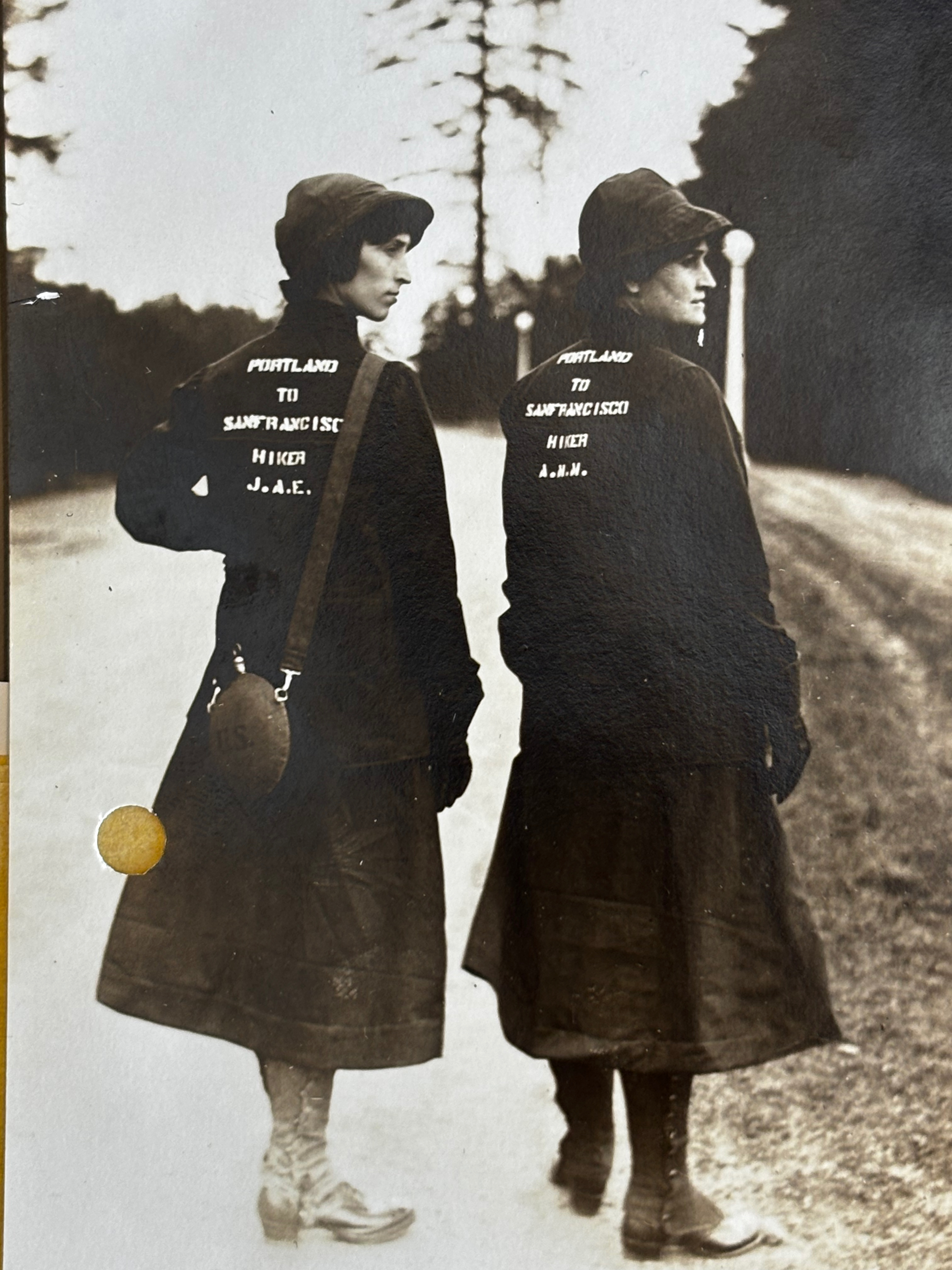
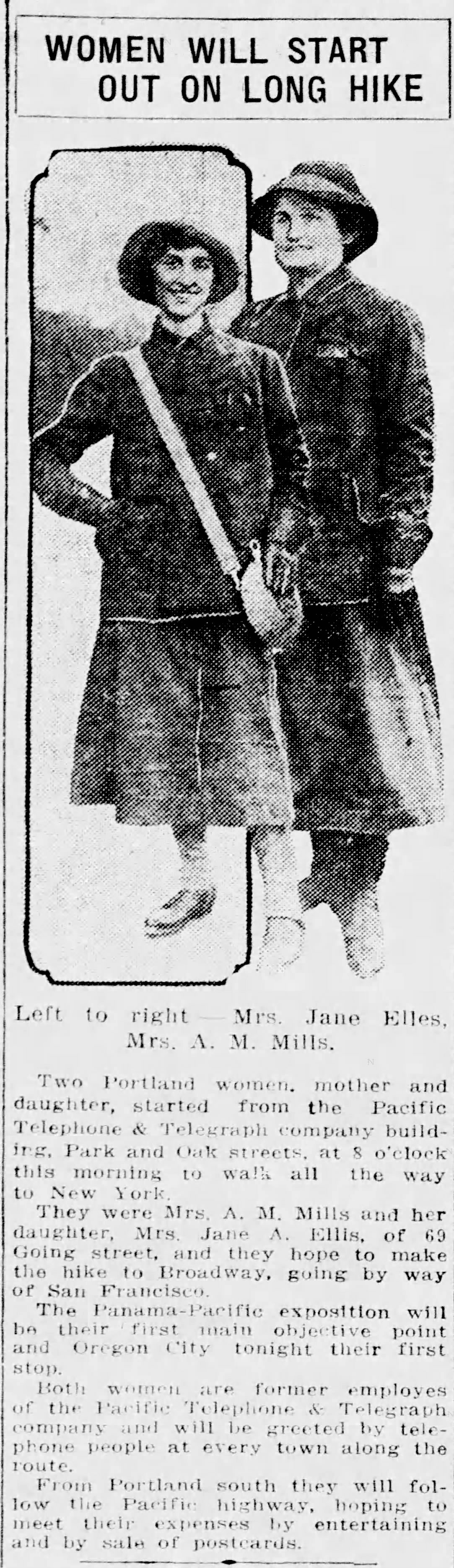
In March 1915, Jane A. Ellis (left, age 25) and her mother Anna Metkser Mills (age 47) prepare to walk from Portland to San Francisco in 40 days. Photo courtesy Portland City Archives, a2000-003.

Walking from Portland to San Francisco and then to New York?

We found carbon copies of eight letters in Mayor Albee’s “Walking Trips” file, all addressed to whom it may concern, as credentials for walkers setting out from Portland in twos and threes, each for different reasons, headed somewhere else: Helena, Montana, Los Angeles, San Diego, Phoenix, New York City. About the same time Jane and Anna set out, three Italian immigrant men left Portland to walk the entire borders of the United States. They too carried a letter from Mayor Albee.

Many of the West Coast walkers were bound for the Panama Pacific International Exposition, San Francisco’s turn at something like the Lewis and Clark Exposition Portland hosted in 1905. Plus, long distance adventure walking was definitely a thing in the middle 19-teens.

As is our custom, we wanted to know more, so we turned to genealogy and the newspapers for insight, where the plot thickened and we got to know this mother-daughter duo a little better. In addition to being walkers and experienced outdoorswomen, they were talented storytellers, musicians and dancers, and as we came to learn, Mother Anna was pretty good with a gun.

First, some basics: Anna Metsker Mills was born in Indiana in 1868 and came west with her husband John. They had three children in Portland: Veta, two years older than Jane, and John, two years younger. In a double tragedy of tuberculosis, Veta died at age 16 and John died at 17. Anna and John’s marriage soon ended, bonding mother and daughter, who both worked for Pacific Telephone and Telegraph Company in Portland.

Here’s a photo we found in a genealogy database of Jane in 1914, the year before the walk, atop the brand new Pacific Telephone and Telegraph Building downtown at SW Park and Oak. She was 24.

Source: Ancestry.com

By the time Jane—who also sometimes went as Jana—joined her mother for their walk in the spring of 1915, she had lost both of her siblings to tuberculosis, seen her parents divorce, been married at age 17, divorced, and had borne two children, one died at birth and the other was seven years old during the spring of the big walk, living with his single father—a real estate broker—in  southeast Portland.

You get the picture: these were two resilient people who had known deep loss and sacrifice. You can sense the steel of them from that first photo.

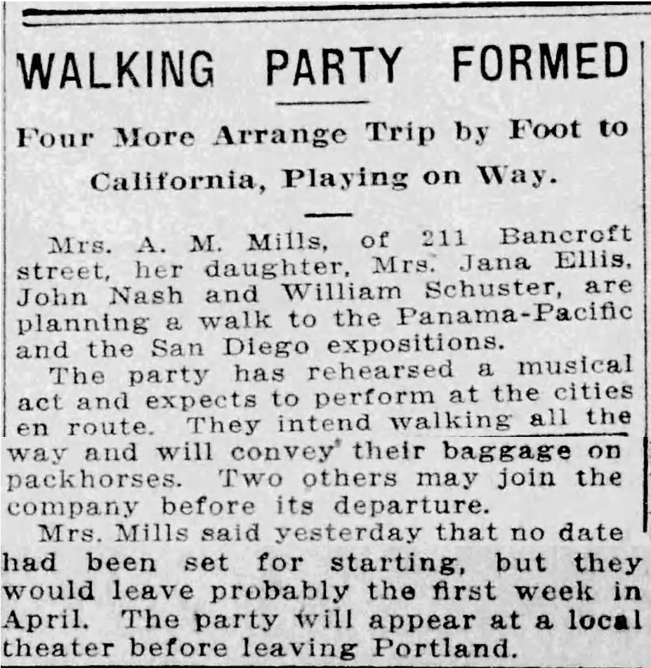
They were smart and planful as well, telling the Oregon Journal on March 22, 1915 they had been planning this journey for two years, and had even taken out a classified ad in the Journal to recruit another member of their party, a musician. All part of their strategy for making ends meet along the way.

Before leaving Portland (they were not the first group of walkers to head south that spring) the newspapers wanted a word. Or maybe these two wanted to make sure the newspapers knew.

Regardless, settle in for a good read and let’s follow along as their stories gain momentum the farther south they go.

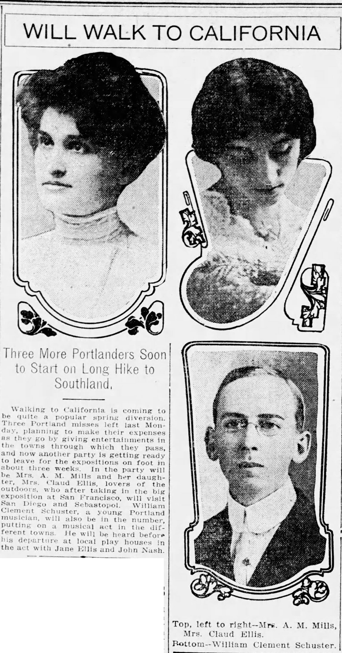
From The Oregonian, March 11, 1915

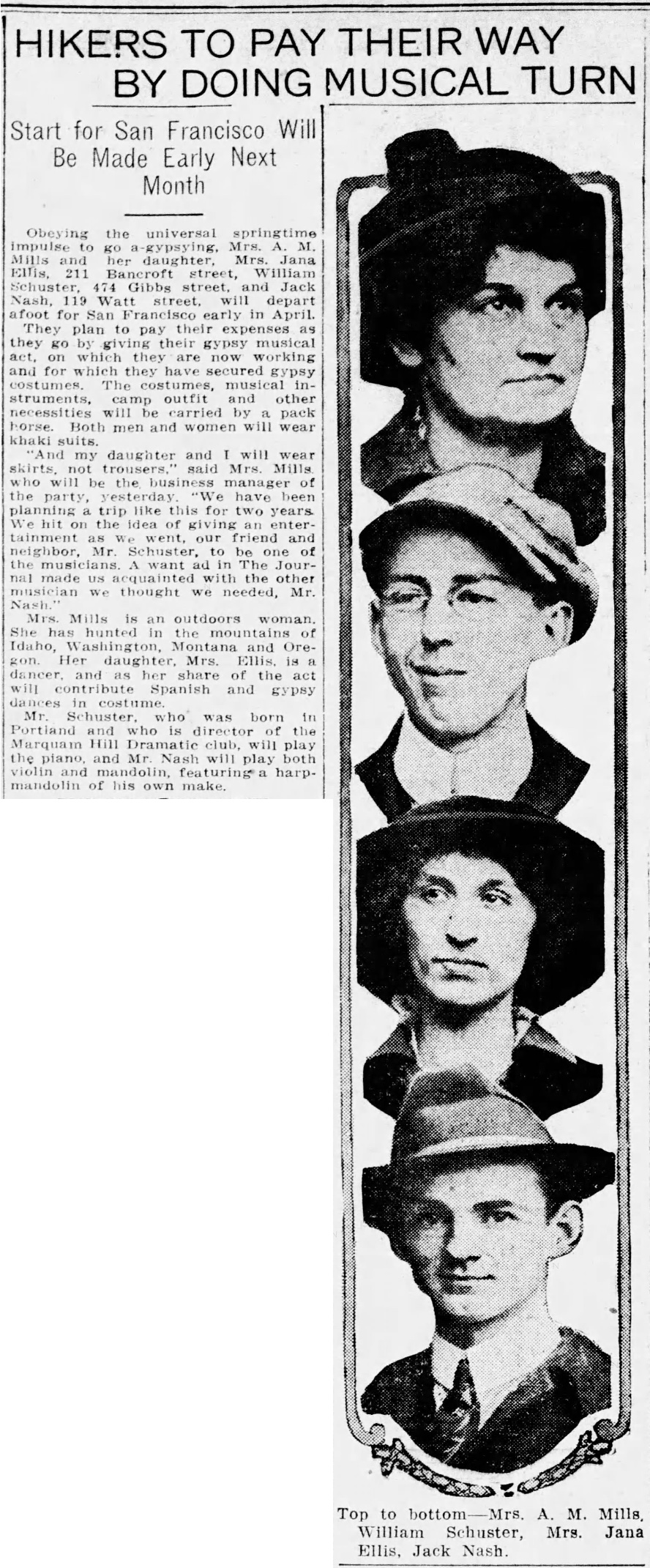
From Oregon Journal, March 14, 1915

From Oregon Journal, March 22, 1915

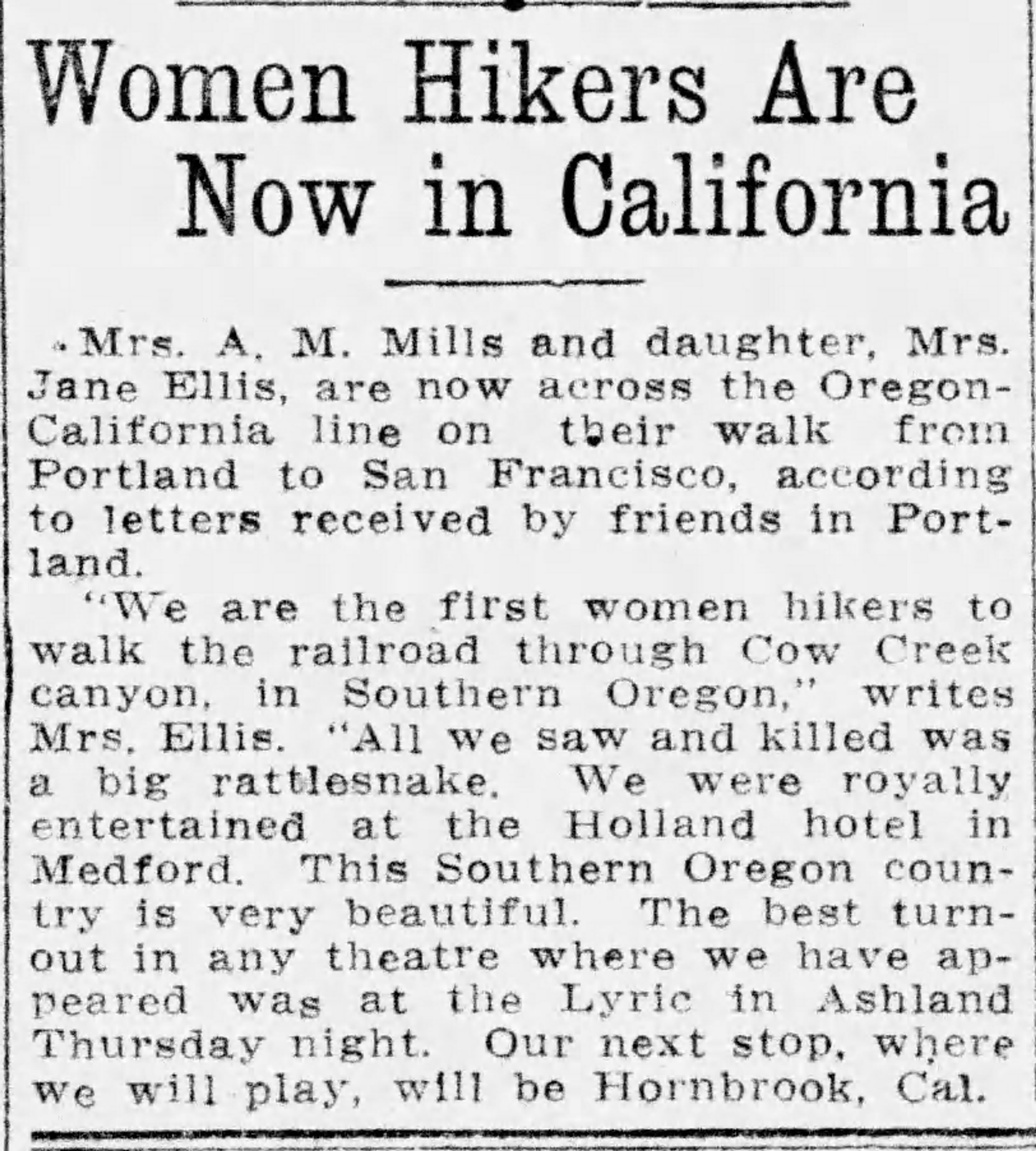
From Oregon Journal, April 29, 1915

From the Statesman-Journal, May 4, 1915

The Albany Democrat Herald noted when the pair passed through there on May 8th “They left Portland without a cent and are making their expenses by appearing in theaters, etc. along the way.”

As they neared Douglas County, the Roseburg News-Review tracked their movements: on May 20th musician John Nash and singer Katherine Vernon joined them in Oakland, Oregon north of Roseburg. May 28th they were in Grants Pass. June 1st they passed through Medford, and the paper reported they were navigating by following the telephone lines, hauling their baggage on horseback, and staying in telephone offices whenever they stopped. They seemed to pause for a while in Ashland, giving multiple well-attended performances at the Lyric Theatre.

From Oregon Journal, June 5, 1915

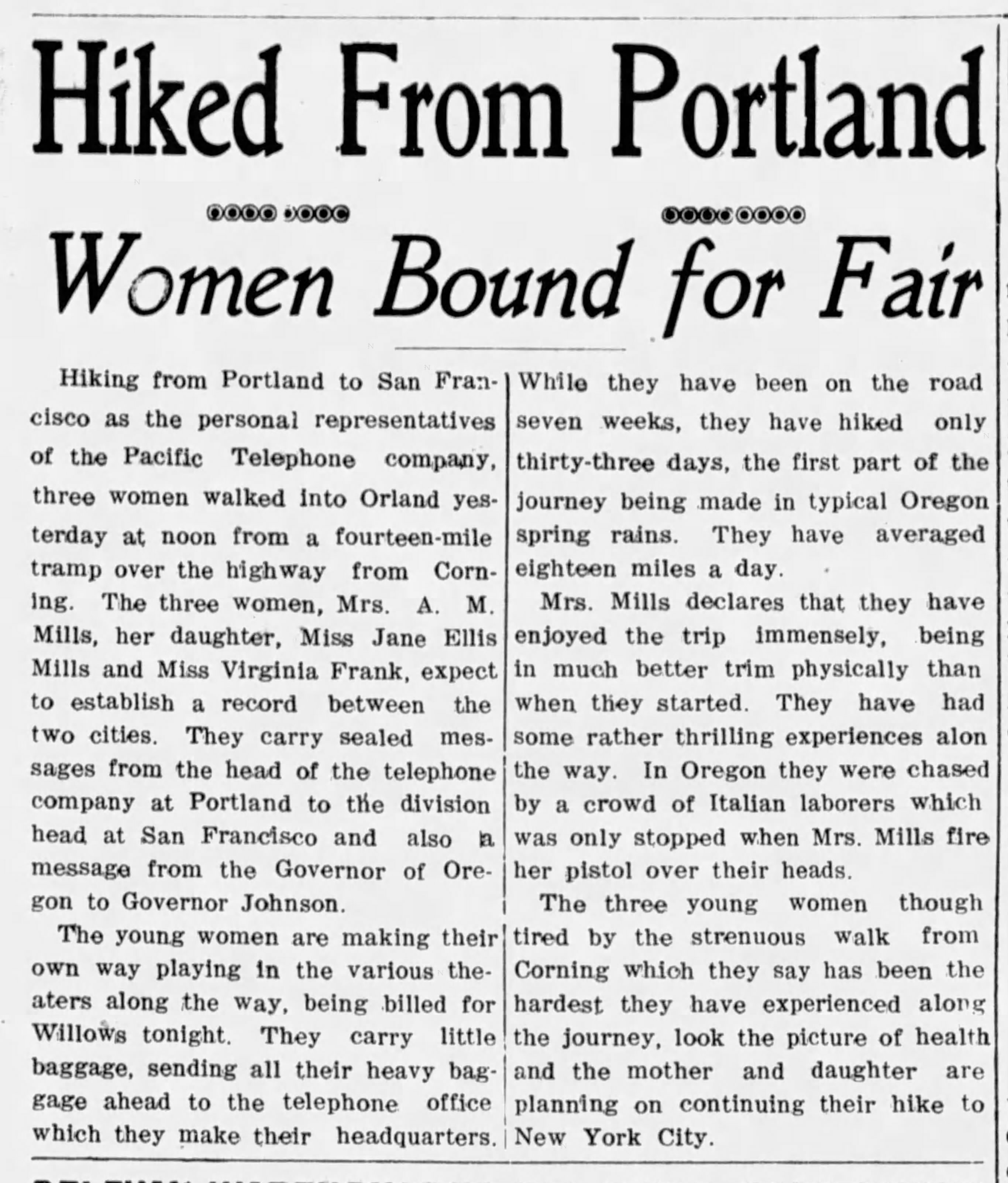
From the Orland, California Register, June 23, 1915

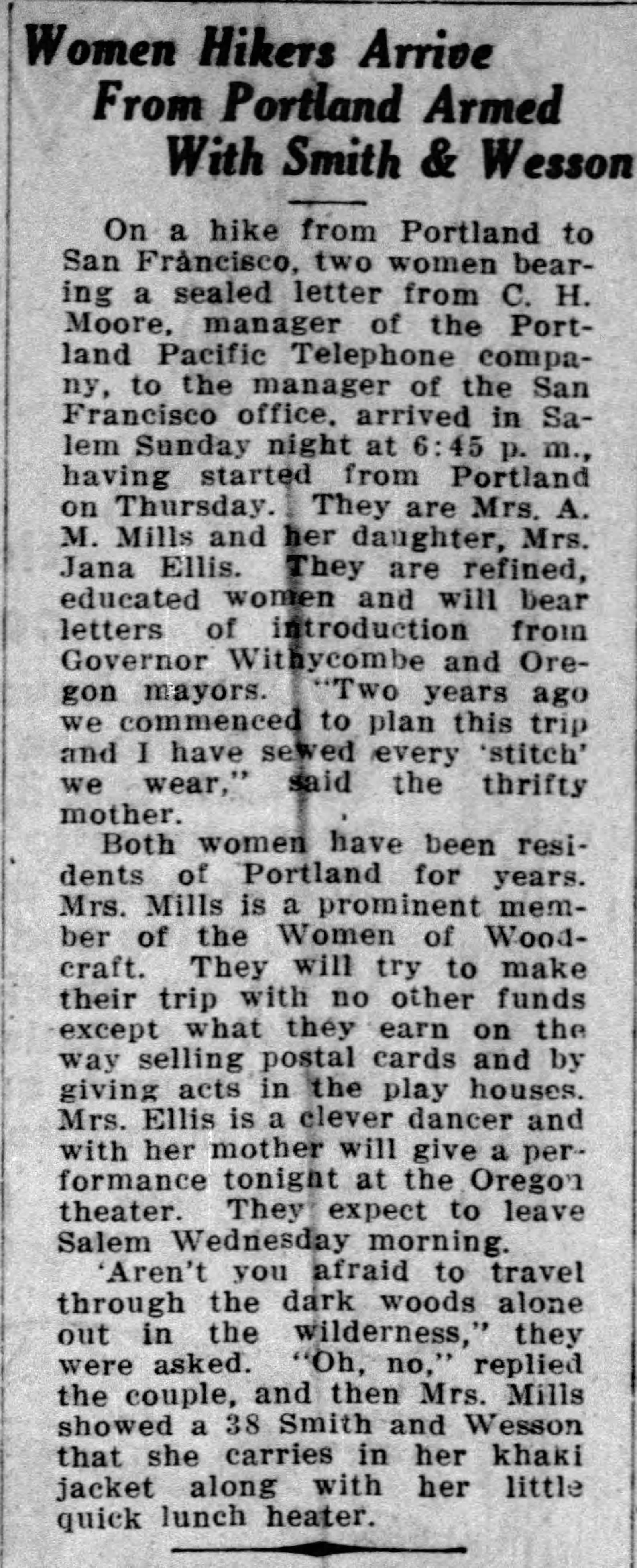
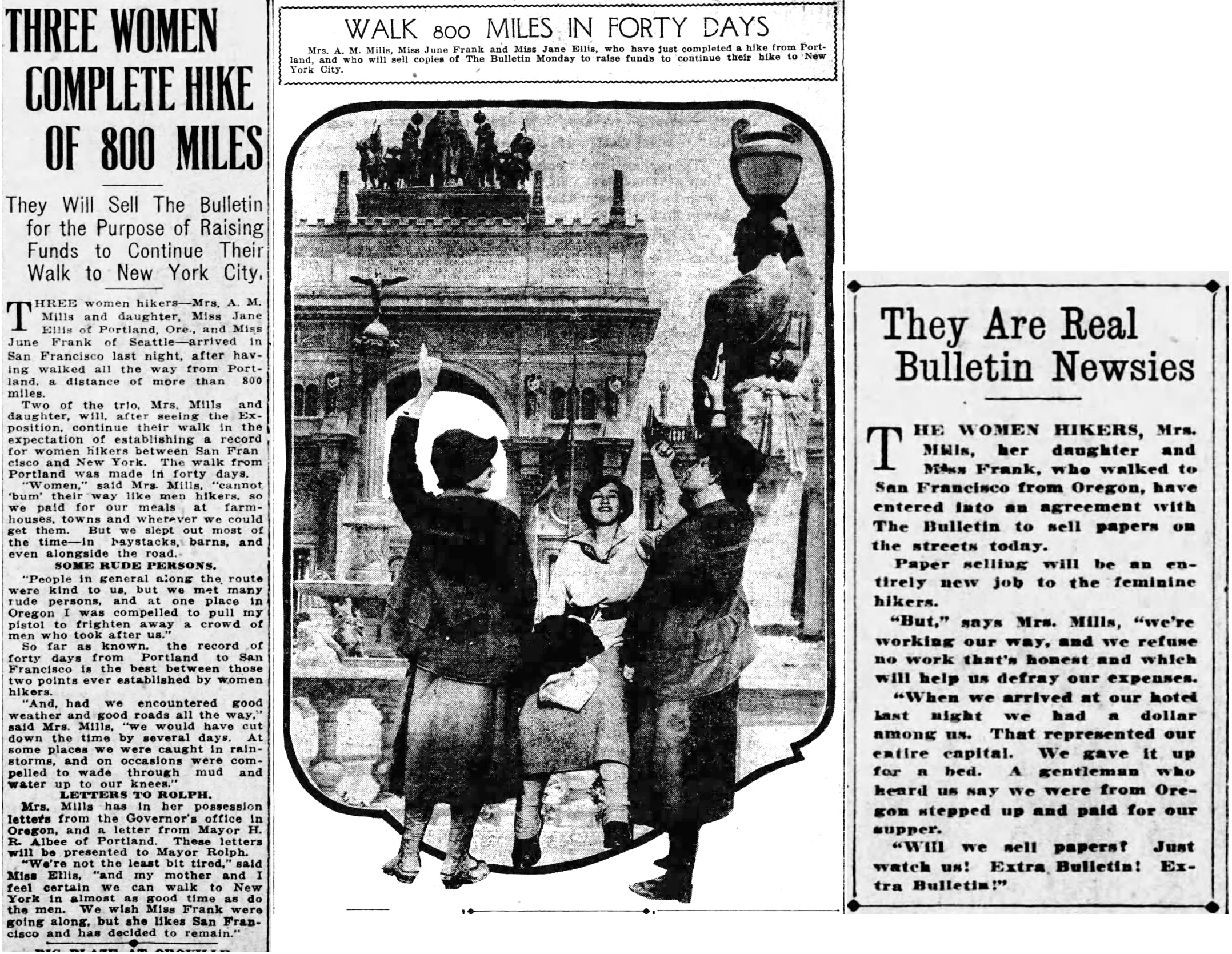
At last, on July 11th, the group—now down to three—arrived in San Francisco. Their stories and a photo—and a sidebar about selling newspapers on the street—appeared on page 4 of the July 12, 1915 San Francisco Bulletin. Click on this for a good read (and look for the Smith & Wesson).

But that’s the last we hear of them, nothing further about going on to San Diego or New York, or any points in between. We’ve had a good look around at newspapers along that way, and there’s nothing. We have to rely on genealogy to give us hints about how their stories end.

They both return to Portland, where daughter Jane marries in 1919, 1923 and 1930, regains custody of her son Wilbur and sets up house with new husband Oscar Severson on SE 17th Avenue, where we find her in the 1930 census working as a debt collector. Living in the house with them is mother Anna, who later dies at home on August 19, 1935 at age 67, and is buried at Lone Fir Cemetery.

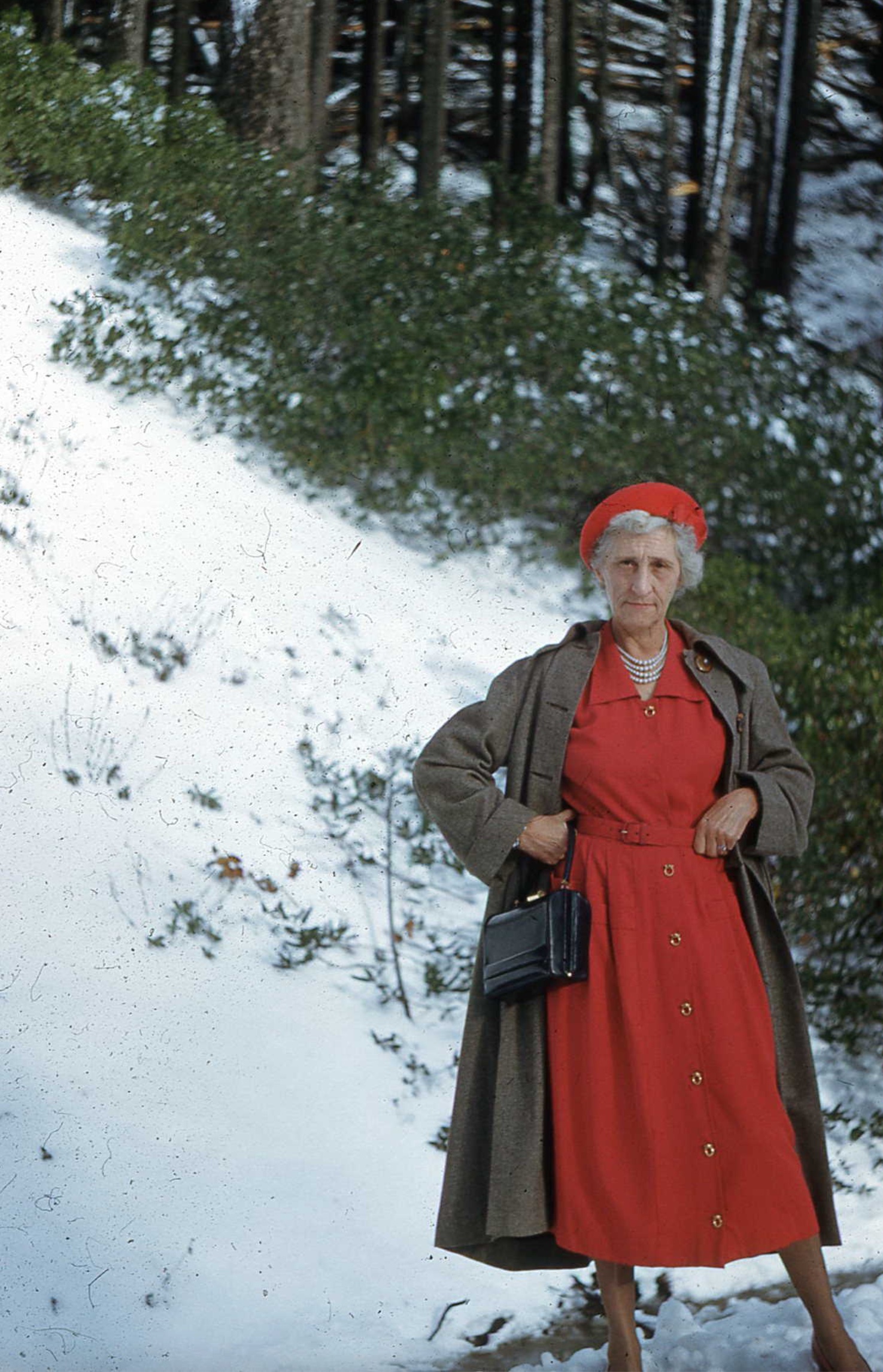
In the early 1950s, Jane and Oscar leave Portland to live near her adult son in Los Angeles. One photo of her from those years convey Jane’s character, showing her in red dress and pearls in some snowy pass. Was she retracing the walk?

Source: Ancestry.com

Oscar dies in January 1955 and Jane lives on in Van Nuys until July 6, 1967 when she dies at age 76. Death notices and obituaries don’t remark on the big walk of 1915. But now we know, thanks to a serendipitous morning in the archives, a letter from Mayor Albee, and a photograph of mother and daughter peering into the future.

1913 photos reveal new perspective at Gravelly Hill – 33rd and Fremont

Every now and then in my research, I’ll find something—a memory, photograph, map or  document—that really sticks with me and defines the way I think about a place.

This month I found a batch of mis-identified photographs when searching at City of Portland Archives that resulted in an absolute jackpot from 1913, opening a fresh window into the past near NE 33rd and Fremont.

Once known as Gravelly Hill, the area was indeed a gravel pit for many years in the late 1800s, and later the repository for all of the eastside’s household garbage between 1923-1924, then known as the Fremont Sanitary Landfill.

But before the landfill, back in 1910 as subdivisions crowded in around the big pit, questions were raised about the basic stability of Fremont Street, which was just below the brow of the Alameda ridge and ran right along the north edge of the pit. Developer Benjamin Lombard, who platted the adjacent Olmsted Park about that time, even sued the city for violating its own ordinance about gravel pits.

So, no secret: that slope South of Fremont was a gravel pit.

But as it turns out, it wasn’t just a gravel pit. It was a GIANT gravel pit. See for yourself:

You’ll want to click into this for a good look. Looking east along Fremont toward NE 33rd from about today’s NE 32nd Avenue. Sewer pipe stacked along the eastern edge of NE 33rd, which slopes downhill left to right. The roof of the house visible at treeline in the center is the Barnes Mansion, 3533 NE Klickitat, which was then brand new. City Archives Photo: A2009.009-3611 (mislabeled as Lombard Street)

In 1913, a photographer for the Department of Public Works visited the pit and brought back 11 amazing images that got buried in the archives. They’re large-format glass plate negatives, not prints, and for years have been filed away in envelopes under “Lombard Street” at City Archives. I suspect few people have ever seen them. A few weeks back, something else I was looking for led me to these glass negatives.

I photographed each plate and made positive prints to be able to better visualize the scenes. And as I studied that first picture and figured out it wasn’t showing Lombard Street, but Fremont Street, I knew this would be a find to remember.

After that first photo, there were these next two, clearly taken as a pair, to illustrate the depth and breadth of the pit. Both are unquestionably tied to the Gravelly Hill landscape. Here I’ve melded them together to create a single image:

Looking north into the gravel pit at NE 33rd and Fremont, December 1913. Click to enlarge. View would be from between today’s Siskiyou and Klickitat streets, looking uphill. The house at far left is today’s 3251 NE Alameda Terrace. The house at far right is the top of today’s 3305 NE Alameda. A sign is visible at upper right for a new subdivision, placed in the cutbank on the northeast corner of 33rd and Fremont. Segments of sewer pipe are visible stacked there. Today, the pit is filled with three city blocks and more than 50 homes. City archives photos, left: A2009.009.3619; right: A2009.009.3620.

Here’s a bit more context from neighborhood historian R.A. Paulson, writing in The Community Press on October 1, 1975:

“From the earliest recollections of those familiar with the area, this was a worked out gravel pit, the excavation of which had been finished many years before but still showing the signs of one-time activity. As late as 1919 and 1920, the pit formed a precipice going down sharply from near Fremont possibly 100 feet or so to the level of Klickitat and extending between 32nd place and 33rd Ave. Coming from the west, Kllickitat Street was unpaved east of about 29th with the cement sidewalks ending there but even between 26th and 29th these sidewalks were impassable because of the overgrown bushes and small trees.


“The gravel pit had been a lush source of rock and gravel for someone way back and the solid bank of this material had originally sloped down from Fremont at the same grade as the present 33rd Ave. This had been scooped out over a period of perhaps 50 years or more and most likely went into improving the lanes, roadways and public highways for miles around, certainly for the country roads that became 33rd Ave. and Fremont Street.


“The bed of the pit showed evidence that work and even habitation had gone on there but at the time of World War 1, only a monolith of stone, too difficult to remove with pick and shovel, reared upward from the new level.”

Here’s a detail from a 1925 aerial photo that shows the extent of the pit and the still-forming street infrastructure. The pit covered two-plus blocks, from NE 33rd to NE 31st, between Fremont and Klickitat.

Detail from a 1925 aerial photo showing the intersection of Fremont and 33rd, labels added for reference. Dashed lines indicate eventual location of NE 32nd Place and NE 32nd Avenue. Click to enlarge. Aerial photo courtesy of City of Portland Archives.

Stay tuned for eight other gems in this collection that are just as knock-your-socks-off amazing as these three. Next up: we’ll take a close look at the intersection of NE 33rd and Fremont 111 years ago, absolutely recognizable to today’s eye.

Another View | 30th and Emerson

Recently we’ve written about the adaptive reuse of a former neighborhood grocery store located at the northeast corner of NE 30th and Emerson. Its rebirth as a health clinic and neighborhood coffee shop is as inspiring as another story is disappointing: the impending loss of the Logan Grocery at NE 33rd and Alberta.

Today’s post provides a 40-year look back at NE 30th and Emerson and is the fruit of time spent at one of our favorite places, Portland City Archives, where we’ve been recently working on several research projects (the Vernon water tank is in the pipeline, so to speak, and we’ve found some great photos of that giant coming soon).

While searching for views of some former local grocery stores we’re tracking, we came across this gem from 1980. Click in for a good look.

Looking northeast at the corner of NE 30th and Emerson, 1980. Courtesy of Portland City Archives, image A2011-028 APF/15624. A quick look back through newspapers and directories from the 1980s confirms that Premier Real Estate Services, owned by Wayne Jacox, operated from this storefront.

Here’s a similar view today:

NE 30th and Emerson, January 2019.

No telling when the thin clapboard siding went on (or the T-111 siding came off) and the transom windows were removed. Upstairs windows haven’t changed, nor has the utility pole out front with the stop sign on it. The corner entry is gone, as is the 30th Street entry to the upstairs apartment. Gas meters are still in the same place as 1980. And from the 1980 picture, you can see the two distinct storefronts from the way-back past that align with what the 1924 Sanborn map shows at 1122 and 1124 East 30th Street North.

Definitely worth 1,000 words. Thanks City Archives!