Searching for the 1920s Alameda woodcutter

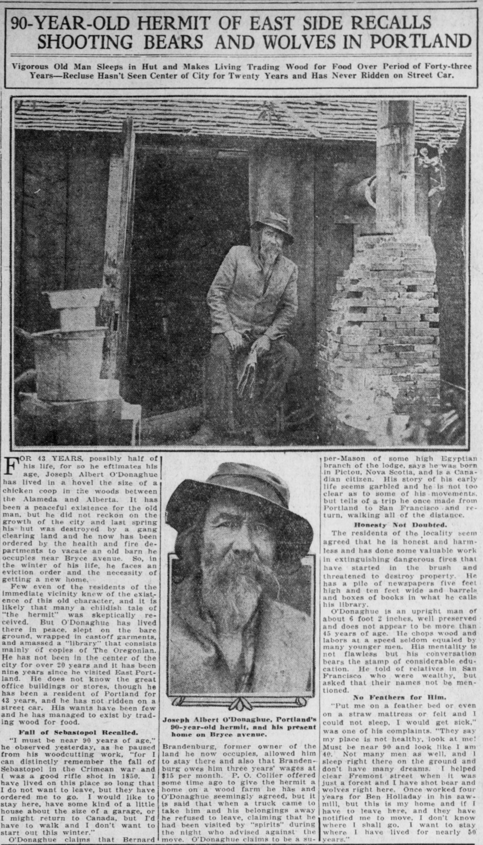
A few years back, about this time of the year, we found a story in The Oregonian from the fall of 1921 that caught our attention. It was about a so-called hermit, a woodcutter who had lived much of his life in a one-room shack near Bryce Street, before Bryce was even a street and before the neighborhoods were built.

The newspaper story was trying to be one of novelty, but underneath it was actually a story of displacement. O’Donaghue was being moved on from the shack in the woods where he lived because land was being cleared and houses built.

Joseph Albert O’Donaghue told of helping clear forests to make the roads we know today, and of wolves and bears he’d killed right here on Alameda Ridge.

Some of it sounded a little fantastical. Like his memories of being a rifleman in the Crimean war 70 years earlier. Of being at least 90 years old. Of walking from Portland to San Francisco and back again.

But a bunch of it had a ring of truth and carried enough information that 100 years later, we could do a little diligence on his stories.

So before we apply some research tools to Mr. O’Donaghue’s story, read the piece below that ran in The Oregonian back on September 18, 1921. And if you want to get in the right frame of mind, you might also read our post Time Passes In Alameda from December 30, 2010, reminding us of so many layers of history here in these neighborhoods.

A careful read of the 1921 story helps us identify certain things to fuel our inquiry:

  • Researchers like a name like Joseph Albert O’Donaghue. Distinctive and traceable.
  • He was from Pictou, Nova Scotia, Canada.
  • He worked for Bernard Brandenburg, and his Bryce Street shack was on property Brandenburg owned.
  • He knew P.O. Collier (who offered him a new place to live).
  • He was a Mason.
  • He was a firewood cutter.
  • He had family in San Francisco.
  • He was a reader.

That’s enough to get us going. Here’s what we found:

The 1910 federal census shows O’Donaghue at age 67, single, living as a “hired man” with two other boarders and a cook in an unaddressed building near 37th and Fremont. It lists his birth year as 1843, from Canada, his father from Ireland, mother from Scotland, and that he arrived in the US in 1878. He reported himself as working full time as a farm laborer. We couldn’t find him in the 1920 census.

The annual Polk city directories track O’Donaghue’s presence like this:

  • 1888 listed as a laborer, boarding somewhere in East Portland (that was us before we became part of Portland proper in 1891).
  • 1906 listed as a laborer, boarding near Fremont and 36th.
  • 1916-1917 listed as a laborer, living near NE 35th and The Alameda.
  • 1921 still working as a laborer, living near NE 35th and Fremont.

His trail goes cold after the 1921 newspaper story, no city directory listings. Nothing. Then in March 1927, a death notice in Esson, British Columbia for Joseph A. O’Donaghue, age 80. Is this our man? Hard to know.

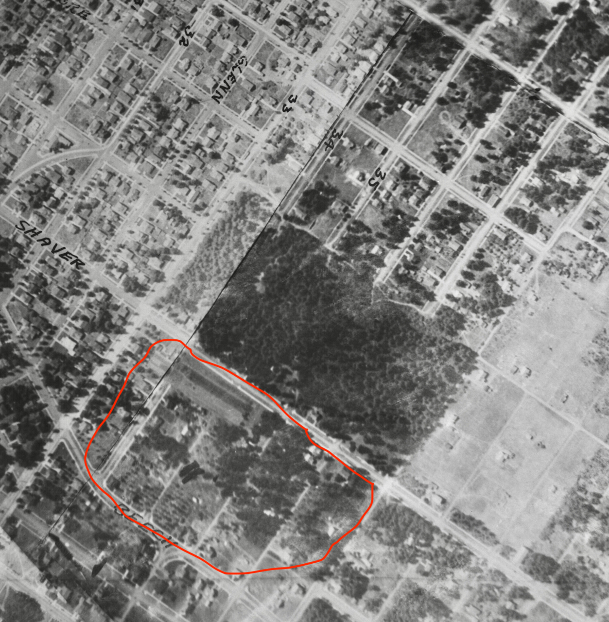
So to the next question: where was O’Donaghue’s shack? We know the property where he lived was owned by Bernard Brandenburg, who owned quite a few lots in the Spring Valley Addition, east of NE 33rd.

Spring Valley is one of the oldest plats in the area, filed on November 6, 1882 by “Clara L. Files, Spinster,” and encompassing the area east-west between 33rd and 37th and north-south between Skidmore and Bryce, including today’s Wilshire Park.

Brandenburg owned six lots which today make up the north end of the two blocks just south of Shaver between NE 33rd and 35th (when 33rd was the only road out here, the numbered streets in this vicinity didn’t exist). We’ve circled them below in red. If he lived on property Brandenburg owned, we’d guess that could be the location of O’Donaghue’s old shack.

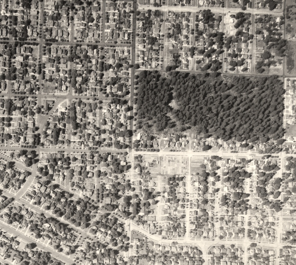
Here’s a look at the 1925 aerial photo, with the Spring Valley Addition circled in red. Was the shack somewhere out there?

1925 aerial photo over the Spring Valley Addition. Bryce is incorrectly labeled as Beech. The dense stand of trees is today’s Wilshire Park. Aerial photo courtesy of City of Portland Archives.

Perry O. Collier was a popular and successful local real estate salesman who worked these properties as they came on the market. He may have been the one who handled the Spring Valley property deal with John L. Hartman, the big-time Portland attorney-banker-developer behind Rose City Park and other major subdivisions. Hartman bought the Spring Valley Addition property and replatted it for subdivision in June 1921. Those plans are probably what was leading to O’Donaghue’s ouster in September 1921.

This is where the story might bump into something we already know.

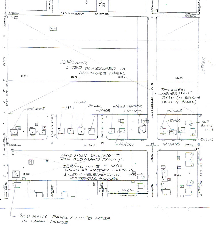
Not long after starting the blog—way back in 2007—we met three of the “boys” who grew up in this part of the neighborhood in the 1930s and 1940s. As often happens, our conversations led to questions, maps in hand, that would help turn back the clock. The boys told us about an old man who lived in this area, and we wrote about it in the post Memory Fragments | An old man and his dog, and a follow-up post Memory Map, which featured handwritten notes made on an old Sanborn map from one of the boys—Dick Taylor—about that exact property…that it was owned by the old man’s family. Hmm.

Is this our man? We’ll never know.

But the trip back in time is enough to reset our mental picture of the neighborhood we think we know today, and to feed our imagination. Think about that the next time you’re out on an evening stroll up Bryce on a cold night at the end of the year.

Wilshire Park claims its history

We’re pleased to report that a new friends group has formed in support of Northeast Portland’s Wilshire Park. We’ve been in touch this week with a history assist as they get the Friends of Wilshire Park website up and running. Right now their site features minutes from the inaugural meeting this week and some information that might look familiar to AH readers, but stay tuned for more as plans develop and more neighbors get engaged. The next meeting of the Friends is Wednesday, April 25th at 7:00 p.m. at nearby Bethany Lutheran Church, 4330 NE 37th Avenue.

As a refresher, the 15-acre park located just east of NE 33rd Avenue–once part of the Jacob Kamm Estate–was slated to become a tourist campground in the 1920s, a plan that provoked quite an uproar in the neighborhood. And in the 1930s, multiple developers had plans for subdivisions before the city bought the lands with emergency funds in April 1940 (spending a grand total of $28,500).

This detail of an aerial photograph from 1943 shows the 15 acres of trees and rough trails. Though the city owned the parcel at this time, there were no developments or facilities yet. Have a look at the rest of the young neighborhood…plenty of vacant lots. It was (and is) a green island in the midst of the neighborhood.

So many other interesting stories and memories over the years: Christmas trees cut in the 1920s and 1930s from the “33rd Street Woods” as it was known; the World War 2 “victory gardens” planted along the park’s southern edge; the jackstrawed piles of trees and branches left over from the Columbus Day storm of 1962; the generations of baseball players, soccer players, runners and dog walkers who have loved this place. Given its role in our local history, and in our daily lives today, Wilshire Park deserves a few more friends.

We wish them well.

Wilshire Park | The Rest of the Story

Today, it’s a major landmark both here on the ground in Alameda-Beaumont-Wilshire, and even from the air: the 15-acre rectangular patch of tall Douglas-fir trees surrounding baseball diamonds, open fields, picnic areas and a dog park. We know it as Wilshire Park, and many of us benefit from it every day.

Wilshire Park very nearly became a 1920s auto campground, and then a 1940s subdivision.

We can take Wilshire Park for granted today because of a series of events tracing back to an investment made by one of Portland’s wealthy early residents, Jacob Kamm (1823-1912), who made his fortunes in the steam navigation business. Kamm also dabbled in real estate investment and had strategically purchased parcels downtown and at the edges of Portland, including the 15 acres of woods just north of the Alameda Ridge off the old county road (today’s NE 33rd Avenue), which he platted as the Spring Valley addition in 1882. When Kamm died in 1912, the tract had been untouched, and his estate was valued at $4 million. Sorting out the estate took years and was frequently in the press.

An effort to turn the park into a KOA-style automobile campground in 1920 was cancelled with prejudice by vociferous Alamedans who were worried about its impact on property values and didn’t like the notion of a non-residential and transient-based activity being so close to their homes. After that fight, which involved petitions, community meetings and a high level of consternation with city government, the fate of the 15 acres rested for a few years.

Remember that the early 1920s were a major boom period for the construction of homes in this area. All around the 15 acres, new subdivisions (and lots of kids) were springing up: the Willamette Addition, platted in 1888 and bounded loosely by Skidmore on the south and Alberta on the north (though the original plat was never fully built-out); the Wilshire Addition, platted in 1921 and roughly including the area from NE 33rd to NE 42nd between Fremont and Prescott; the Beaumont Addition, platted in 1910; and Olmsted Park—just  west of 33rd across from the woods—was as well established as its neighbor Alameda Park. Kids from these neighborhoods were already using the wooded area as their playground, with a maze of improvised trails, forts and other secret places nestled into the thick brush and trees. It seemed a natural to become a real city park, with playgrounds and picnic facilities for organized events.

The Wilshire Addition Community Club—a kind-of early neighborhood association and social club—was the first to call for acquisition and development of the park, submitting a proposal in September 1926 for the city to float a bond measure to fund the work. But Portland Parks Commissioner C.P. Keyser felt the chances of a voter-passed measure were too slim because not enough planning and survey work had been completed, so the effort stalled.

Left on their own after the city chose not to take up the cause, neighbors began direct negotiations with the Kamm estate. By 1933, an agreement had been reached that allowed the property to be used as a park—still owned by the Kamm family—as long as the planning and development work was funded and conducted by neighborhood residents. In a Monday morning, March 27, 1933 news story, The Oregonian reported the following:

“Improvement of a 15-acre tract of land has been started by residents of the Wilshire District to convert the site into a park. The land has been made available by the Kamm estate with the proviso that improvement expenses be assumed by persons living in the neighborhood. Volunteer workers gathered at the tract Saturday and yesterday and cut away underbrush and cleaned the land for further improvements.”

A passing reference about who was actually coordinating the work provides insight into the way some people though of the 15 acres in those days: the work party was led by the city’s Nuisance Division, and the Clean Up Campaign Committee of the Junior Chamber of Commerce.

Thanks to work parties like this, and continued use by neighborhood kids, community interest continued to build in the mid-1930s—with the property still in the hands of the Kamm estate—until a proposal was made in the fall of 1937 to have the city purchase the property with a localized bond measure. Backers of the proposal knew that time was running out to keep the park as a park, and told The Oregonian in December of 1937 that “this is the last chance to get it. Contractors want to take over the property to build homes.” They also continued to make the case that the nearest proper park was too far away for children to use. The 15-acres was still a glorified brush patch.

Working with neighbors, the city proposed assessing the agreed purchase price of $28,500 across 3,000 homes within the surrounding vicinity, less than $10 per household. This did not go over well with some, and a firestorm of letters to the editor and complaints to City Hall boiled over. More than 30 percent of the 3,000 homeowners had actually signed petitions opposing the fee, though not all were against the park acquisition itself, if the city could find a way to spread the cost city-wide.  In 1937, Portland was in the grips of a recession that followed the Depression, and joblessness and foreclosures were headline news on a daily basis.

One letter writer, local resident Spencer Akers, put it this way:

“The controversy over the proposed Kamm park seems to be fanned to a red heat. Where is the justice in a comparatively few individuals being obliged to shoulder the purchase price, especially since the depression has reinforced its destruction siege by the surprise attack of the ruthless ‘recession?’ If the city is too poor to purchase the property than why in the name of common sense should we, who happen to live in the immediate vicinity, be judged as financially able to raise the whole purchase price? I know of several families in this district who are actually in need, and a bombshell of this nature would play havoc with their tottering defenses.”

A staff-written editorial from The Oregonian on December 27, 1927, made an eloquent case otherwise:

“If the Kamm tract were certain to remain available for a park for a number of years, and the majority of the residents of the district desired that buying of it be deferred, there could be no sound objection to such a course. It is likely, however, that the tract soon will be developed for residential purposes if it is not taken over for a neighborhood park. The national cry for more housing and the probability of advantageous federal financing for building make that seem inevitable, if the city does not act now. The price is reasonable, probably lower than it will ever be again. No other property is to be had for the purpose. The proposed assessment [of $8.60 for a 50 x 100 foot lot] would be unlikely to be a hardship on anyone; the return of value to the property owners in the district would be obvious.”

But forward-looking arguments did not prevail, and after all the fuss, the city dropped the proposal.

Meanwhile, kids kept using the 15 acres, brush continued to grow, crimes were reported being committed in the woods, and developers sought to purchase and build on the property.

This detail of an aerial photograph from 1943 shows the 15 acres of trees and rough trails. Though the city owned the parcel at this time, there were no developments or facilities yet. Have a look at the rest of the young neighborhood…plenty of vacant lots.

The story goes quiet again, until a brief headline in the April 10, 1940 issue of The Oregonian: City Acquires Kamm Tract. The short, page 4 story reports only that the City Council took the action by emergency ordinance and was acquiring the land from the estate at a cost of $28,500, financed with a two-year loan from the First National Bank that would be paid off from city funds. Perhaps a development proposal led to the tipping point and the emergency action…that part of the story is untold. The public purchase of the property brought an important chapter to a close, and secured the land for the future.

However, almost as if the neighborhood needed something more to fight about, controversy boiled again in February 1941 about naming the newly acquired parcel, with some wanting to call it Jacob Kamm Park, which stemmed from a proposal made by the Sons and Daughters of Pioneers. The majority of surrounding neighbors lined up behind a proposal to call it Wilshire Park. After several stormy meetings on the topic, City Council agreed with the neighbors and adopted Wilshire Park as the official name.

The Hamnett family on the north side of Wilshire Park, looking south, 1948. Note the gravel surface of NE Skidmore street. Photo courtesy of John Hamnett.

By 1950, the city had cut and removed much of the underbrush, constructed the ball diamonds still in place today, and even built a playground, which featured among other things, old Fire Engine Number 2, a 1918 model that was finally decommissioned from service at the SW 3rd and Glisan fire house.

Wilshire Park baseball game, 1956. Looking west.

Many other memories remain about the park, including the family that lived in a home at the far southeast corner of the woods around the turn of the last century; Christmas trees cut in the 1920s and 1930s from the “33rd Street Woods;” the jackstrawed piles of trees and branches left over from the Columbus Day storm of 1962; the generations of baseball players, soccer players, runners and dog walkers who have loved this place.

Proposed Alameda Auto Camp Meets Protest

The first chapter of the Wilshire Park story…


Faithful Alameda History blog readers will know that protests were not uncommon in the early years of our neighborhood life, usually around schools and churches, and frequently about land use topics. Property owners had sought out this subdivision for many reasons, including a covenant that prohibited all but residential development within the Alameda Park plat proper. You couldn’t build a store or office. You could barely build a church, as we have seen.

Want to build a campground, or as they were known during the day, an auto camp? Forget it. This neighborhood was definitely not buying any such proposal.

Our timeframe for this vignette is the mid 1920s. We’ll remember that at this point, Alameda Park is experiencing exponential growth…the previous few years outpacing all other years combined. There was much new construction, but still many vacant lots, some brush fields, and a sense that while we were the “Tuxedo of Portland,” as claimed in the real estate development ads, we were still on the outskirts of Portland.

That’s when our predecessors first learned about a proposal to build an auto campground right here on our doorstep at 33rd and Mason.

The 15-acre wooded parcel that is today’s Wilshire Park was then part of the Jacob Kamm estate. Kamm (1823-1912) was one of Portland’s wealthiest residents, making his fortunes in the steam navigation business. He also dabbled in real estate investment and had strategically purchased parcels downtown and at the edges of Portland, including the 15 acres of woods just north of the Alameda Ridge. When he died in 1912, his estate was valued at $4 million. Sorting out the estate took years and was frequently in the press. Up here in Alameda, Kamm’s trees kept growing.

So when a plan came along to do something with the property, reported in an innocuous story in the September 12, 1920 edition of The Oregonian, some readers may have just looked at it as another business pitch. Commissioner Stanhope S. Pier was in charge of this idea:


Tourist parks or auto camps were not that uncommon here in Portland and elsewhere. The car was a new toy and tool, and as people traveled the countryside, they needed a place to land temporarily as they explored the area. Think of a KOA campground. Let’s just say that auto camps were in the public consciousness of the day: an enjoyable, convenient and necessary extension of car travel. Here’s a photo from the City of Portland Archives showing one such camp in 1925, somewhere on the Westside.


But after reading the September 12th story, it took Alameda residents only a matter of hours to get up a protest to Commissioner Pier, which eventually turned into a petition drive and then a forceful meeting with Mayor Baker and City Council. In The Oregonian story from October 7, 1920 below, be sure to have a look at the fourth paragraph and its description of Alameda as a “quiet, refined district, composed of a home loving people…”


Faced with a petition and local uproar, City Council had to schedule some time to let Alameda vent and make its case. Below, in the story the next day, October 8, 1920, check out the fourth paragraph, where a description of Alameda’s winding streets, considered an asset by some developers, is spun as a liability when it comes to serving the needs of the traveling public.


In the following day’s story, with some plausible deniability and backpedalling by Pier, City Council quickly reversed direction on the plan and endorsed the neighborhood notion of playgrounds and open parks.


Eventually, the city found property and built an auto park near Peninsula Park in the vicinity of Ainsworth and Albina. Here’s another photograph. The topic of the Kamm Estate goes quiet then, resurfacing six years later in the September 10, 1926 edition of The Oregonian (below)as one of several city park needs being considered.


It would take another seven years until 1933—with the property still connected to the Kamm estate—that the city would seriously consider the idea.

Next Chapter: Conflicts about Paying for the Park

%d bloggers like this: