Recently, we had a chance to visit with Jennie Fennelle, a northeast Portland resident and old house dweller who also runs an interesting podcast called Echoes from the Attic.
Jennie wanted to talk about the discovery, intrigue and challenge of researching old houses and the notion that every house has a story (so many stories) which often lead to other stories, insights and questions.
We had a nice chat, which she turned into Episode 5, a 20-minute piece that covers a little bit about the why and the how of old house research. Might spark your imagination to start doing some digging of your own (here are some suggestions about getting started).
Our favorite from Jennie’s podcast line-up is her first, about the mystique and sentimentality of estate sales, but the whole premise of the show is worth a listen.
Our research into Portland’s early homebuilders continues, with three more profiles which illustrate the range and type of people and companies who built our homes in the early years of the 20th century. These three join more than 40 other builder profiles on The Builders page, including mom-and-pop builders and large scale operators who shaped the neighborhoods we know today. Be sure to have a look and see if you find your address or neighborhood in these lists.
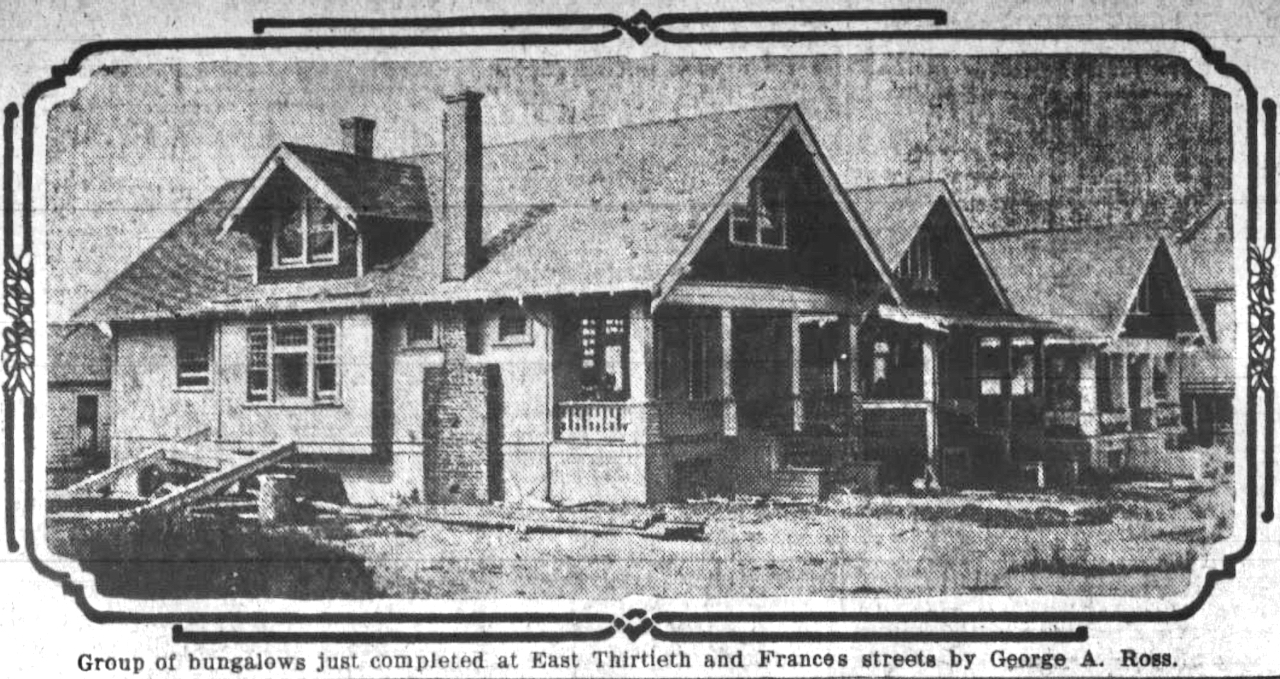
George A. Ross (1877-1958) was one of the prolific builders whose company would be working on multiple homes at the same time. He did it all: builder, designer (but not a registered architect), financier, marketer. Like many of our builders, he was an immigrant who started out by building a home for himself, sold it, and went on to build (and live in) many others.
George E. Weller (1870-1942) had been a dry goods merchant in Raymond, Nebraska before coming to Portland after the Lewis and Clark Exposition to capitalize on the early homebuilding boom. He was 40 years old when he began his Portland house construction business, and like George Ross, built his first bungalow for his own family. Weller later operated the Pacific Building Co. before leaving the homebuilding business and going into real estate. In his early years his motto was Builder of Good Homes ~ Weller-Built is Well-Built.
George Weller – “Builder of Good Homes”
William M. Umbdenstock (1869-1937) came to the business from family money and from fire insurance underwriting in Chicago. Arriving in Portland in 1911, he kept his Chicago company name “W.M. Umbdenstock & Co.” and produced more than 300 homes between 1911-1923, from humble bungalows to much larger colonial-style showpieces. Umdenstock likely did not wield a hammer: his business was business and his company built homes, managed and rented out existing properties and sold vacant lots for others to build. He left Portland for Los Angeles in 1923 to work as an importer-exporter, inventor, and entrepreneur.
Insights about an early Portland builder? We’d like to hear from you.
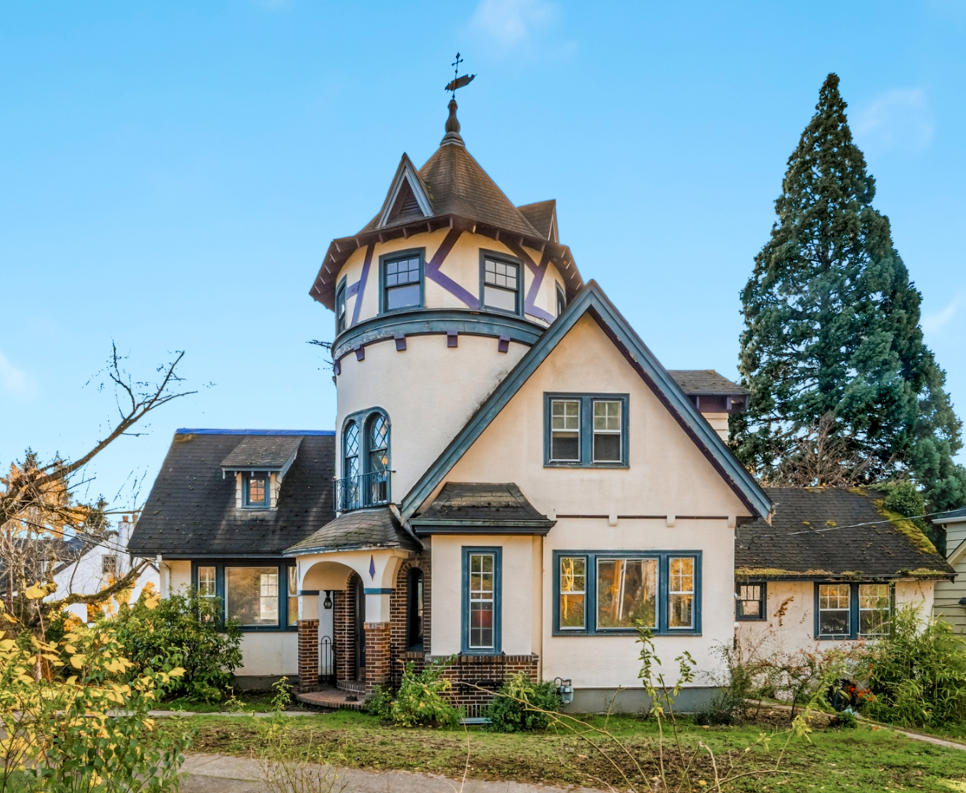
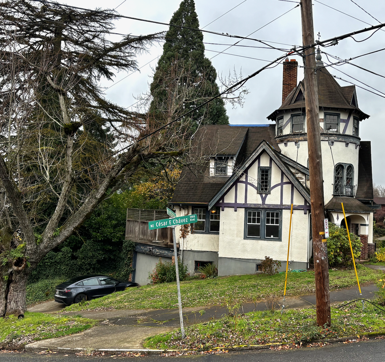
It’s always been a visual landmark on NE Wistaria Drive: the 1928 turreted English Tudor style house that anchors the big downhill bend at the confluence of Wistaria, NE 41st and Cedar Chavez Boulevard. The tower with its tip-top weather vane, 360-degree windows and tent-like roof dormers. The prominent gable ends and half-timbering. The brick, decorated entry way.
They don’t build them like this anymore.
For more than 30 years, we’ve walked by and felt the cry for help from the house and its former owner—who passed away in August—as the weeds took over, the windows cracked, the porch sagged and garbage piled up.
Neighbors are paying extra attention this week because the Wistaria turret house is now for sale. Many are hoping for a capable, patient, history-focused buyer who can bring it back to life.
We walked through this week to take a measure of how much work there is to be done. It is a major fixer-upper. All the building systems will need to be replaced and upgraded: electrical, plumbing, heating and ventilation; new kitchen, new roof. Every surface, finish, floor and window needs TLC. The foundation needs attention too, perched as it is on the slope of the ridge. Don’t forget the landscaping.
While the amount of work to be done is staggering, so is the grace and beauty of the original construction and the uniqueness of so many of the home’s interior spaces. There’s nothing else quite like the top turret room.
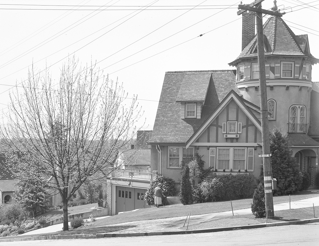
Check out this view of the house from April 1935, showing original owner Anna Hummel watering the garden (photo courtesy Portland City Archives AP/25295) and today.
3880 NE Wistaria Drive is listed by Cee Webster with Neighbors Realty. Cee has a deep appreciation for the character of the house and the reality of the work at hand, and has shared photos which you can find here. Cee will be accepting offers until December 8th at 9:00 a.m
In some ways, the complexity of the house mirrors the story of its earliest years. Built in 1928 by Jens Olsen for German immigrant Carl Hummel and his American wife Anna, the house embodies design aspects from Carl’s growing up years in Reutlingen, Germany.
Carl was a tailor. He and Anna arrived in Portland from Quincy, Illinois in 1907, and operated a tailoring, cleaning and dye business at NE 22nd and Sandy.
In the mid 1930s when trouble was brewing in Germany, Carl, then in his 60s, wanted to be back in his homeland. Working through an intermediary here in Portland, Carl arranged an exchange of homes and businesses with a Jewish German family who were trying to flee to the U.S. but had been blocked by the German government. Correspondence, telegrams and other documents archived by the United States Holocaust Memorial Museum convey the complexity of the exchange.
The situation for the fleeing German family was becoming dire; time was running out. The back-and-forth correspondence is steeped with anxiety and barely-contained impatience, but also with respect. If the families could organize a trade, neither would need to send money across international borders, which was forbidden.
Finally, in November 1936 with an agreement in place and papers approved, Carl and Anna moved home to Germany. Not long afterward, the very relieved Lowen family from Görlitz arrived in Portland as the new homeowners of the turret house on Wistaria. They became naturalized citizens and lived in the house for more than 30 years.
We’ll explore this story—and the unfolding next chapter of the turret house—in future posts.
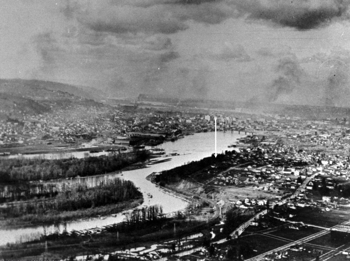
Looking north through southeast Portland and along the shoulder of Ross Island, about 1925. The arrow shows the approximate location of a house somewhere in the mist we wanted to know more about. Image courtesy Portland City Archives, A2011-006.
Sleuthing old photos to determine location, context and insights is a favorite thing to do; the Photo Detective category here on the blog is testament.
But sometimes, the biggest mystery is just finding the old photo.
Such was the case recently when a reader wrote seeking an assist in locating a photograph of a house fixed in childhood memory from the 1950s: his grandparents’ home on the bluff above Ross Island, torn down more than 50 years ago to make room for McLoughlin Boulevard. No known photos of the house had survived.
But in his memory, a version of the house was still there. Burnished over the years and important because it was a house that contained the full arc of life for people he cared about who were also gone. Maybe by having a photo of the house, he could call them to mind, and consider his own experience there as a small person.
When researching houses for clients, we’re always looking for old photos, but there is no single source or easy way to do this. In Portland, it’s worth following your address back through old copies of The Oregonian and the Oregon Journal to see if there is a photo from an advertisement or some random mention over the years. You’d be surprised, it does happen.
Another potential source is Portland City Archives, which has a deep collection of public works, traffic study, zoning study and “stub toe” photos that might include an incidental catch of a place or building of interest somewhere in the background. You can use the search tool called efiles to search by intersection or street.
The stub toe photos are an interesting subset, documenting sidewalk tripping hazards for liability reasons and occasionally catching a house of interest in the background.
The Oregon Historical Society Library has collections of neighborhood photos that are always worth looking through: you might find something you didn’t even know you were looking for.
There are aerial photos too, some of which are available through City Archives, and others through the University of Oregon Library’s Aerial Photography Collection. Dating back to 1925, these images are mostly low resolution and grainy, but good enough to help address larger-scale mysteries. Examining the same place from the air every 5-10 years back to 1925 is fascinating and always humbling to see all we’ve missed and don’t know about a place.
An advanced aerial photo function within the indispensable research tool Portland Maps allows a year-by-year look back to 2006 and then in some cases back to 1948. And of course there is Google Streetview.
But the best sources with the best pictures are always private collections, as in family photo albums and attic shoe boxes of photos, which are also the most challenging and rewarding to find. But that’s another blog post.
Long before construction of McLoughlin Boulevard, the remembered house on the bluff had a Grand Avenue address, and stood on the east side of the street at the corner of Haig. Back in 1912, Grand Avenue was never intended to be a major thoroughfare connecting downtown and the central eastside with outer southeast Portland. Think: quiet, meandering neighborhood street.
Early on in the search, we used aerial photos and Sanborn maps to understand how Grand Avenue has changed. It once followed a slow, looping route along the high bluff to take in the views of the Willamette River to the west, calling to mind the way in which SE Sellwood Boulevard edges high above Oaks Bottom today. In the river just downslope from the house was the north end of Ross Island, with views straight at Bundy’s Baths and Windemuth.
It wasn’t until the late 1930s and early 1940s that Grand Avenue was widened and McLoughlin Boulevard first opened. Given growth in all parts of southeast Portland and northern Clackamas County—and the rise of the automobile in everyday life—traffic volumes began to increase and congestion followed. The Oregon Highway Commission was under pressure to “fix” the problem. By the mid 1960s, traffic engineers with the State Highway Division knew that widening of McLoughlin to six lanes—which had become Pacific Highway East, Route 99E—would be necessary, dooming the former neighborhood street.
By then, the remembered family in the remembered house were gone and the sense of that former neighborhood as a quiet place to look out over the river below was quickly slipping from living memory.
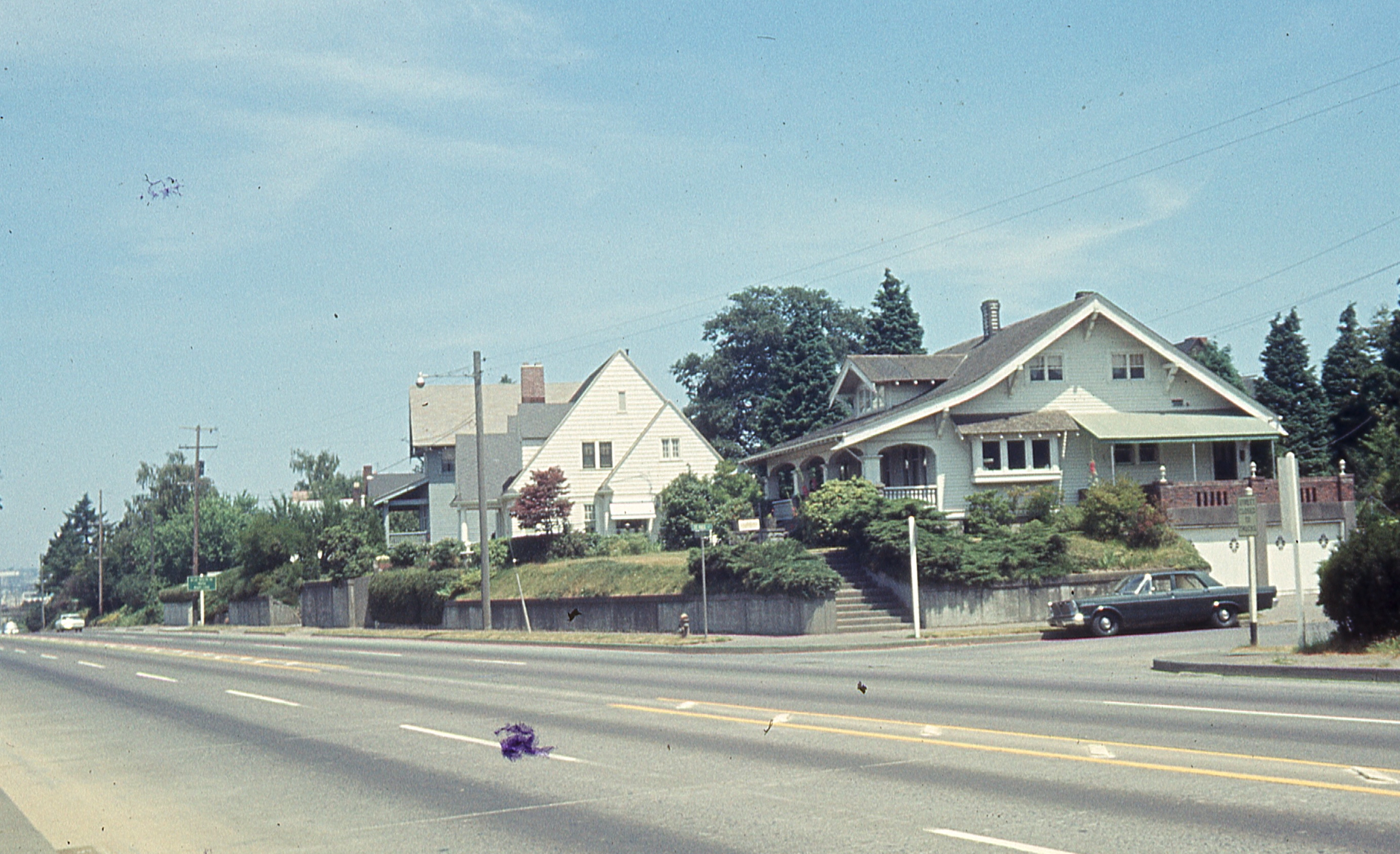
That’s when the studies began: land use studies, traffic flow studies, engineering studies. Surveyors out on the ground taking measurements, and–fortunately for us–taking pictures. And that’s where we were able to pull this house back to life from one sunny Wednesday afternoon in June 1965, through the lens of a traffic engineer. That’s it there on the right, the Craftsman bungalow, dormer facing west. Click in for a closer look.
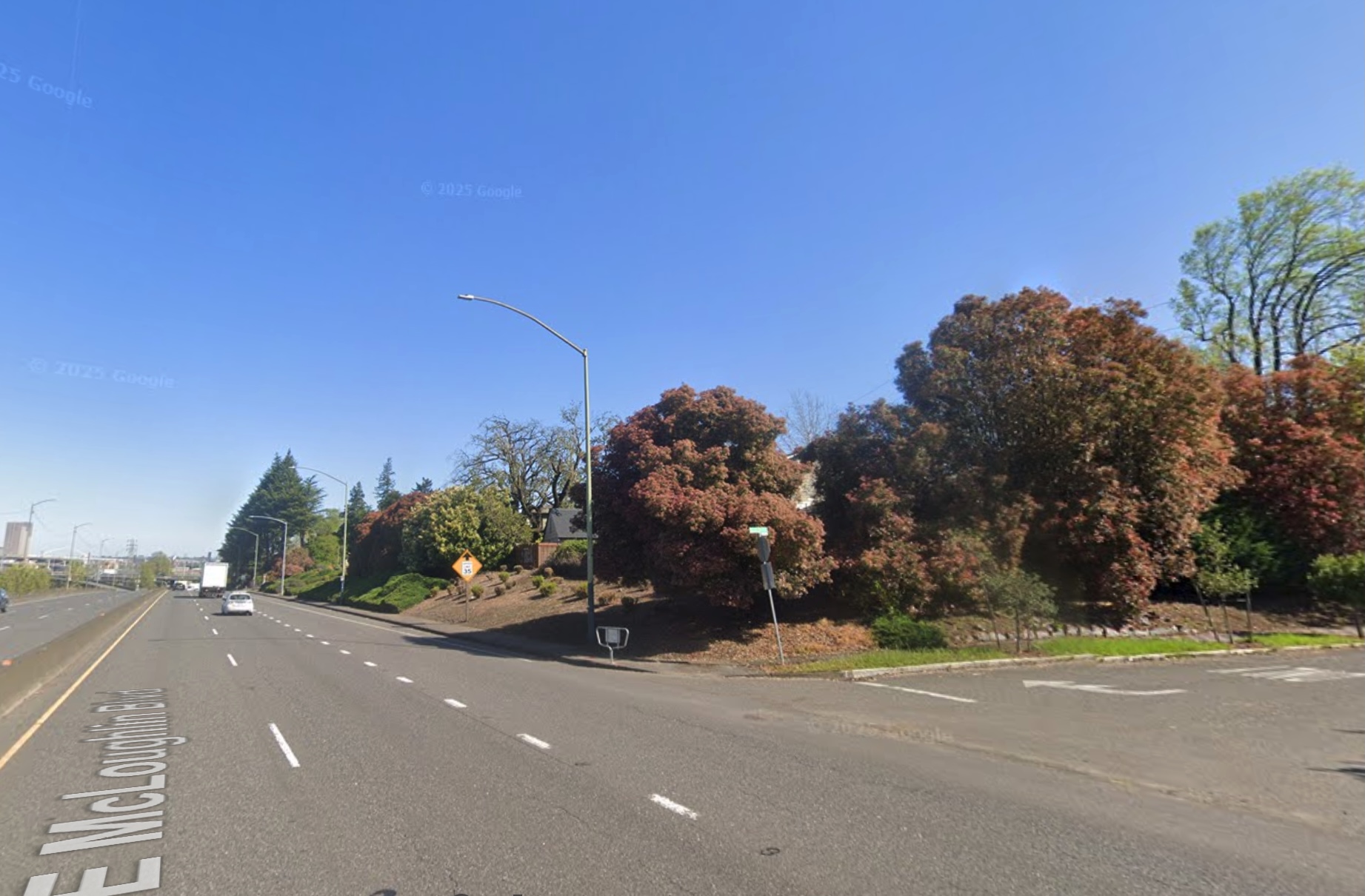
The former 670 Grand Avenue, a story-and-a-half bungalow built in the spring and summer of 1912 by Benjamin F. Doty, a well-known Portland homebuilding contractor and as it turned out father of the young newlywed who lived in this house for most of the rest of her life. This house and nine other adjacent homes from the old neighborhood were torn down in 1970 to make way for another lane of traffic on McLoughlin Boulevard. Below: the same view today (thanks to Google Streetview).
How does the photo compare with the memory? Maybe an unfair question since how does memory ever compare with anything, but we wanted to know. Certain things were familiar.
But just having the photo created a perch from which other memories and imaginings and questions could now rise. And for an old house researcher like us, it felt like finding the precious needle in the overwhelming haystack.
In our continuing quest to learn more about the people who designed and built Portland’s neighborhoods and homes, we’re adding nine more builder biographies bringing our total number of homebuilder and architect profiles to 41. You can find these profiles under The Builder’s tab here on the AH blog. Between them, these nine builders were responsible for hundreds of Portland homes.
In this latest batch, you’ll notice the continued theme: Portland’s housing stock from 1900-1950 was built primarily by immigrants, with Swedish immigrants figuring prominently. Here are some highlights:
Horace Askwith: Built in Laurelhurst and Alameda before taking on the job as Superintendent Architect for the Oregon-Washington Railway and Navigation Company.
Robert Beat:the Scottish designer and builder who built more than 100 houses in Irvington, where he lived. The gold standard of Portland homebuilding.
George Binkey: A hardscrabble builder who focused on the Elberta Addition in the early 1900s before moving to the Coos Bay area.
Oscar Earlson:Built houses on both sides of the river and found time to be a leader of Swedish culture in Portland.
Nils Eklund: Swedish immigrant who saved money with his wife Signe to build their first house, which ended up launching a prolific homebuilding career.
J.W. McFadden:Active builder in Laurelhurst and Alameda, was almost successful in building a commercial building in Coe Circle, and who eventually built a special memorial for Oregon’s most famous dog.
Conrad Mueller: German immigrant builder who bought tax foreclosed lots to stay busy during the Great Depression.
Fred Turner: Changed his name in 1918 to sound more American. Turner built many Northeast Portland homes and an historic apartment building before turning to development in the Burlingame area of southwest Portland.
Thomas Winship: Prolific English-born homebuilder who was the spark plug behind construction of the old Rose City Park Library (now demolished).
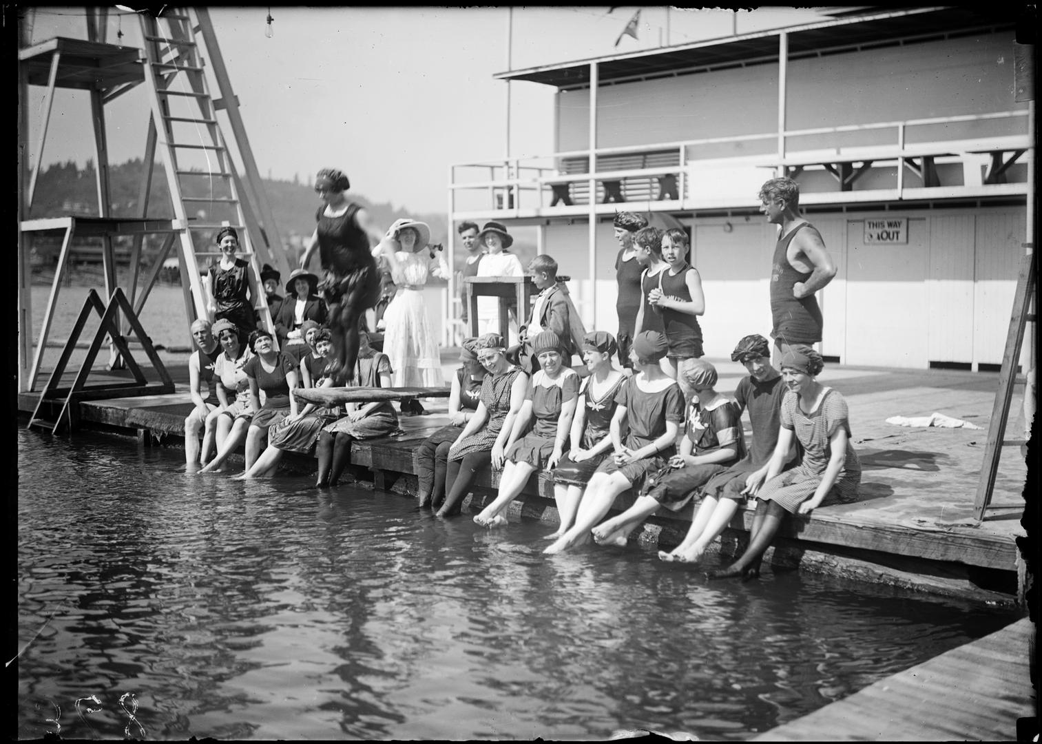
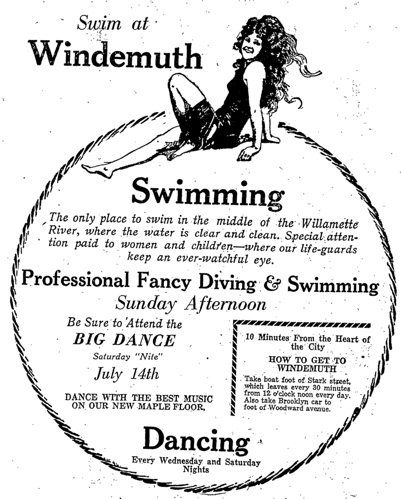
Swimmers at Windemuth. Angelus Studio photographs, 1880s-1940s, University of Oregon, Oregon Digital. PH037_b012_AG00052
News just in from the Oregon Encyclopedia that our entry on Portland’s once-great swimming platform afloat in the Willamette River known as Windemuth, and its on-shore predecessor Bundy’s Baths, has been published. Here’s a link, go take a look. If you haven’t seen the Oregon Encyclopedia before, better bookmark it. The OE is a great source of information on all things Oregon.
Prior to the mid-1920s, during days like the recent heat wave, this stretch of the Willamette River just downstream from Ross Island was a haven for Portlanders trying to stay cool and have fun. In July 1924, swimmers were ordered out of the river due to serious health and water quality conditions due to the accumulation of raw sewage routinely discharged into the river. An eerie parallel to the recent blue-green algae outbreak in the same area.
If you’re hungry to read more about Bundy’s and Windemuth, check out our past posts on the topics:
One of the nice things about a visit to Portland City Archives is the serendipity that comes from hanging around with lots of old documents.
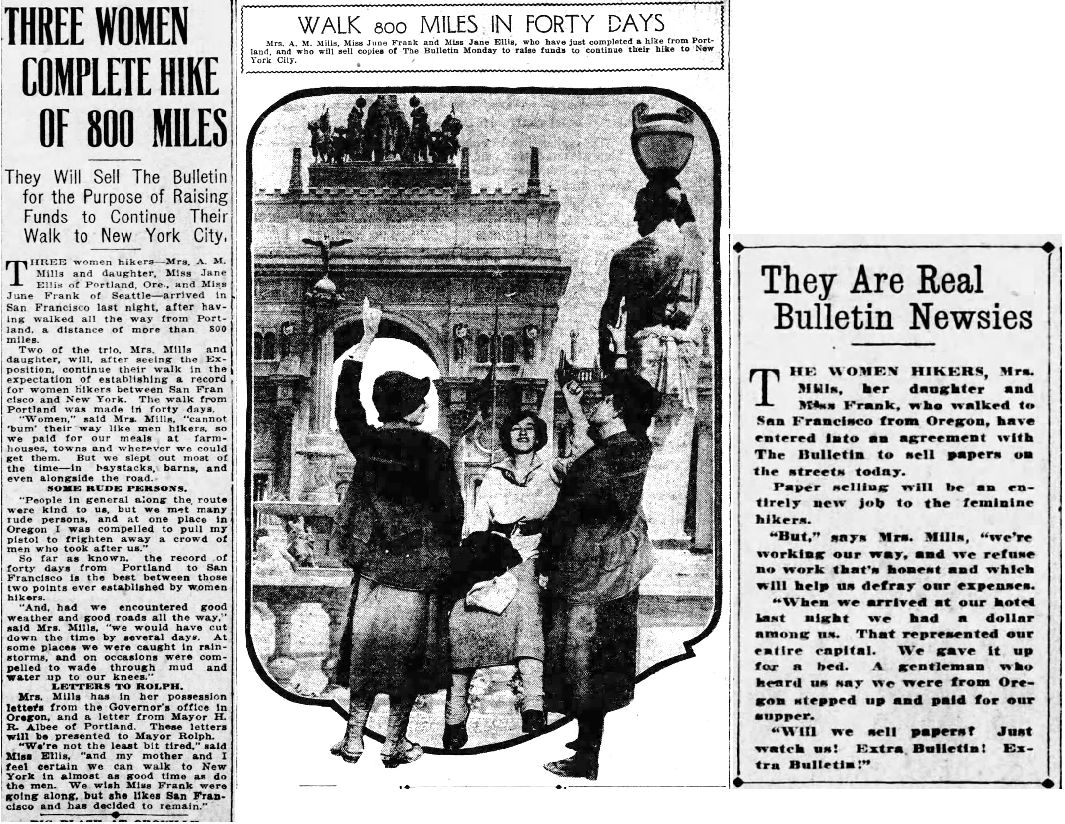
You go in looking for a report related to Willamette River water quality in the early 1900s (which you find), and you bump into a folder of 1914-1915 correspondence from Portland Mayor H. Russell Albee that includes a photo of a mother and daughter, eyes fixed on the horizon, starting out on a big walk from Portland to New York via San Francisco.
For us, serendipity often begins with a photo.
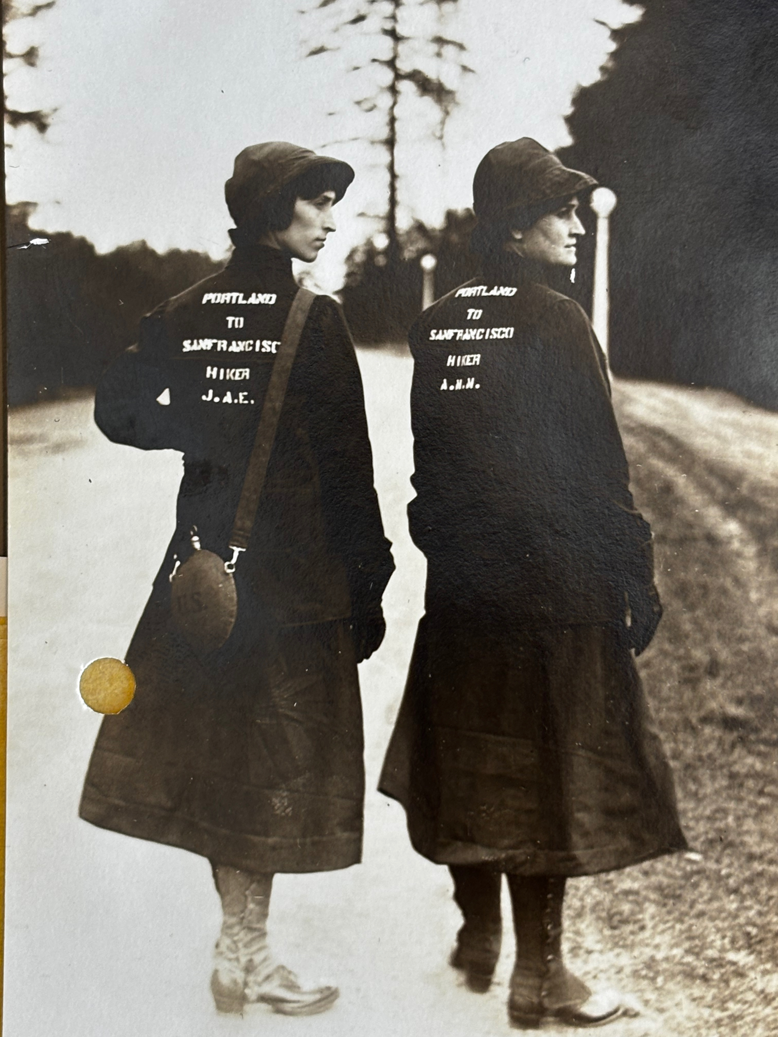
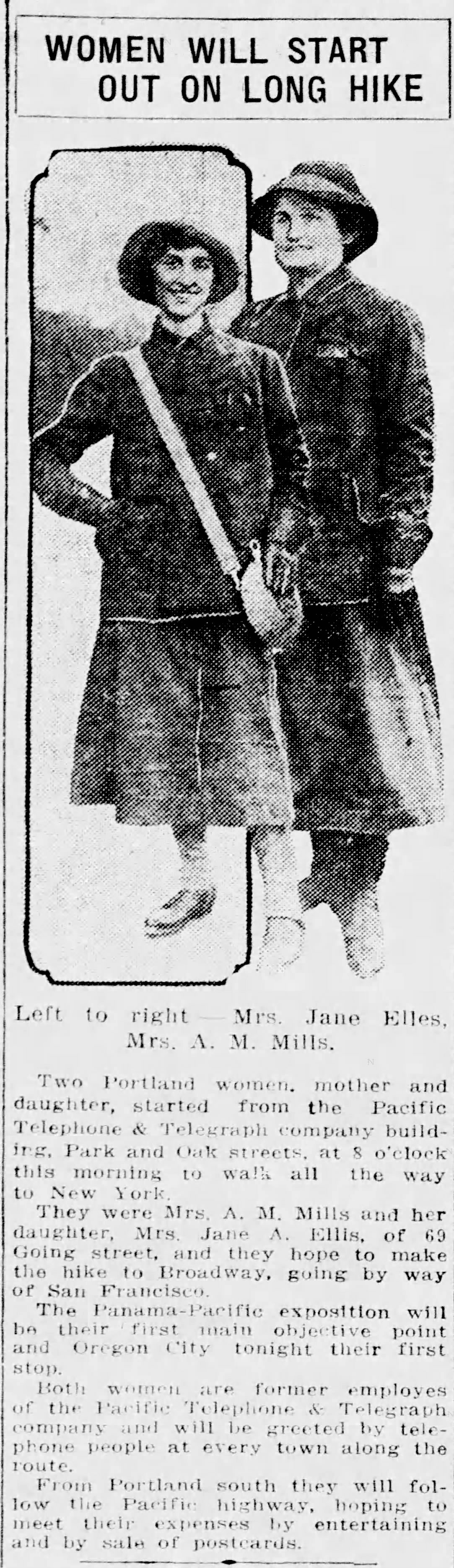
In March 1915, Jane A. Ellis (left, age 25) and her mother Anna Metkser Mills (age 47) prepare to walk from Portland to San Francisco in 40 days. Photo courtesy Portland City Archives, a2000-003.
Walking from Portland to San Francisco and then to New York?
We found carbon copies of eight letters in Mayor Albee’s “Walking Trips” file, all addressed to whom it may concern, as credentials for walkers setting out from Portland in twos and threes, each for different reasons, headed somewhere else: Helena, Montana, Los Angeles, San Diego, Phoenix, New York City. About the same time Jane and Anna set out, three Italian immigrant men left Portland to walk the entire borders of the United States. They too carried a letter from Mayor Albee.
Many of the West Coast walkers were bound for the Panama Pacific International Exposition, San Francisco’s turn at something like the Lewis and Clark Exposition Portland hosted in 1905. Plus, long distance adventure walking was definitely a thing in the middle 19-teens.
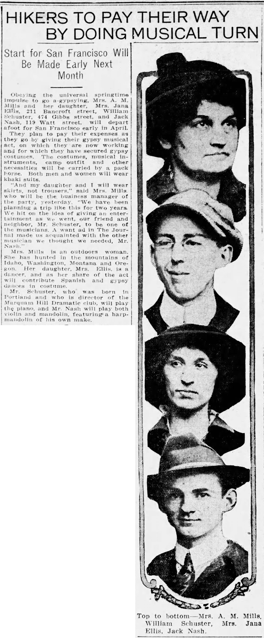
As is our custom, we wanted to know more, so we turned to genealogy and the newspapers for insight, where the plot thickened and we got to know this mother-daughter duo a little better. In addition to being walkers and experienced outdoorswomen, they were talented storytellers, musicians and dancers, and as we came to learn, Mother Anna was pretty good with a gun.
First, some basics: Anna Metsker Mills was born in Indiana in 1868 and came west with her husband John. They had three children in Portland: Veta, two years older than Jane, and John, two years younger. In a double tragedy of tuberculosis, Veta died at age 16 and John died at 17. Anna and John’s marriage soon ended, bonding mother and daughter, who both worked for Pacific Telephone and Telegraph Company in Portland.
Here’s a photo we found in a genealogy database of Jane in 1914, the year before the walk, atop the brand new Pacific Telephone and Telegraph Building downtown at SW Park and Oak. She was 24.
Source: Ancestry.com
By the time Jane—who also sometimes went as Jana—joined her mother for their walk in the spring of 1915, she had lost both of her siblings to tuberculosis, seen her parents divorce, been married at age 17, divorced, and had borne two children, one died at birth and the other was seven years old during the spring of the big walk, living with his single father—a real estate broker—in southeast Portland.
You get the picture: these were two resilient people who had known deep loss and sacrifice. You can sense the steel of them from that first photo.
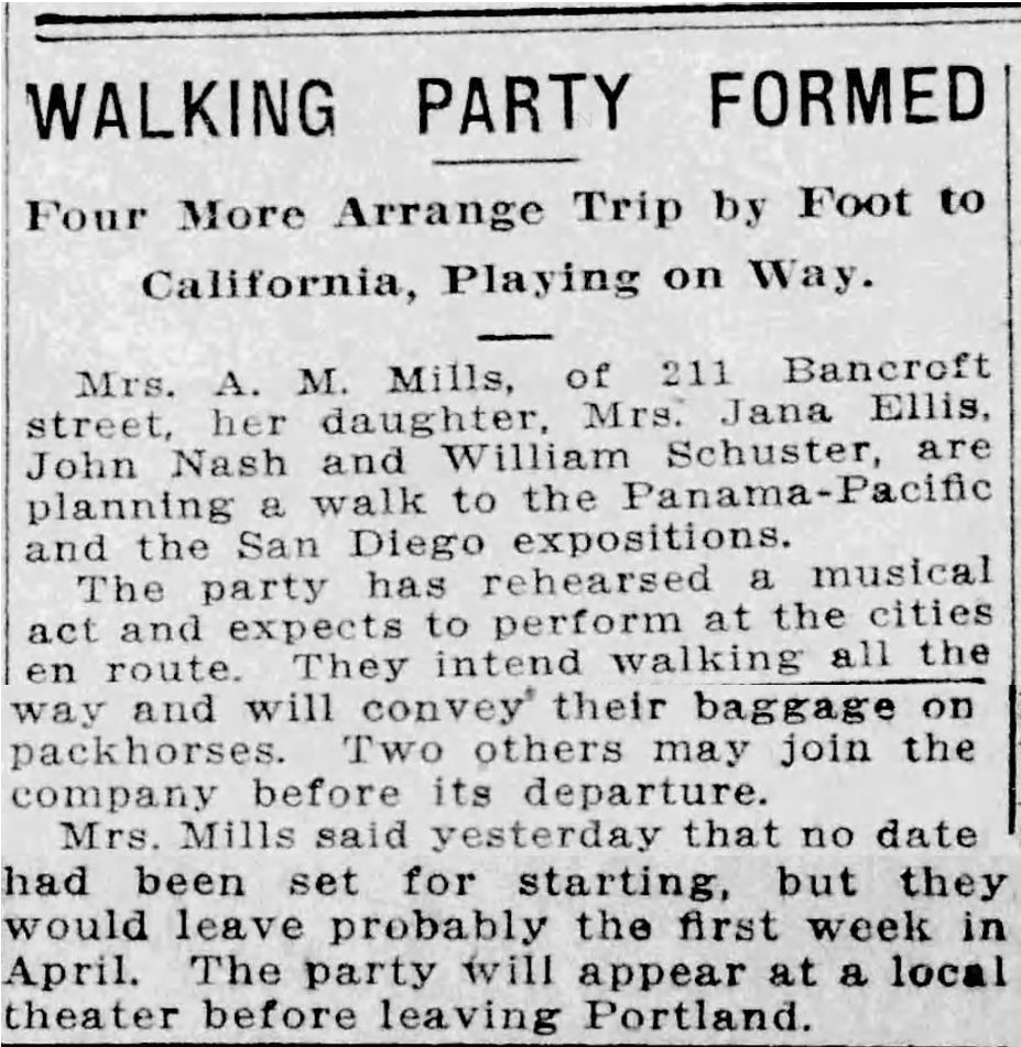
They were smart and planful as well, telling the Oregon Journal on March 22, 1915 they had been planning this journey for two years, and had even taken out a classified ad in the Journal to recruit another member of their party, a musician. All part of their strategy for making ends meet along the way.
Before leaving Portland (they were not the first group of walkers to head south that spring) the newspapers wanted a word. Or maybe these two wanted to make sure the newspapers knew.
Regardless, settle in for a good read and let’s follow along as their stories gain momentum the farther south they go.
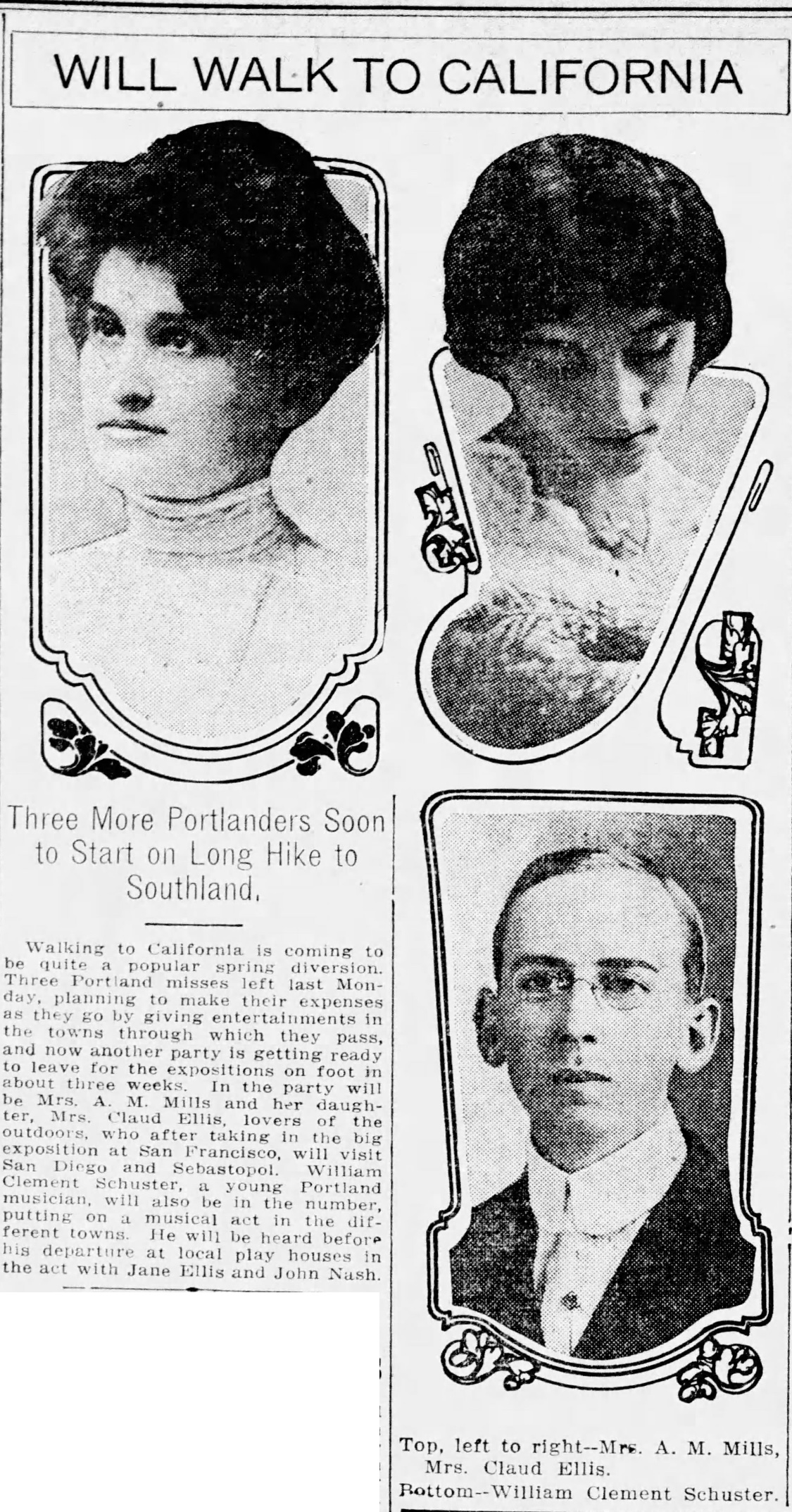
From The Oregonian, March 11, 1915
From Oregon Journal, March 14, 1915
From Oregon Journal, March 22, 1915
From Oregon Journal, April 29, 1915
From the Statesman-Journal, May 4, 1915
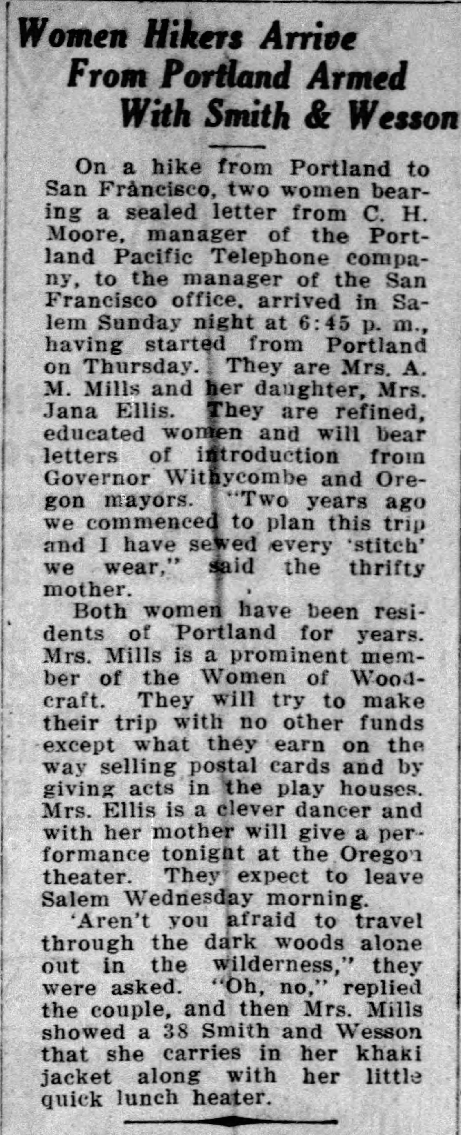
The Albany Democrat Herald noted when the pair passed through there on May 8th “They left Portland without a cent and are making their expenses by appearing in theaters, etc. along the way.”
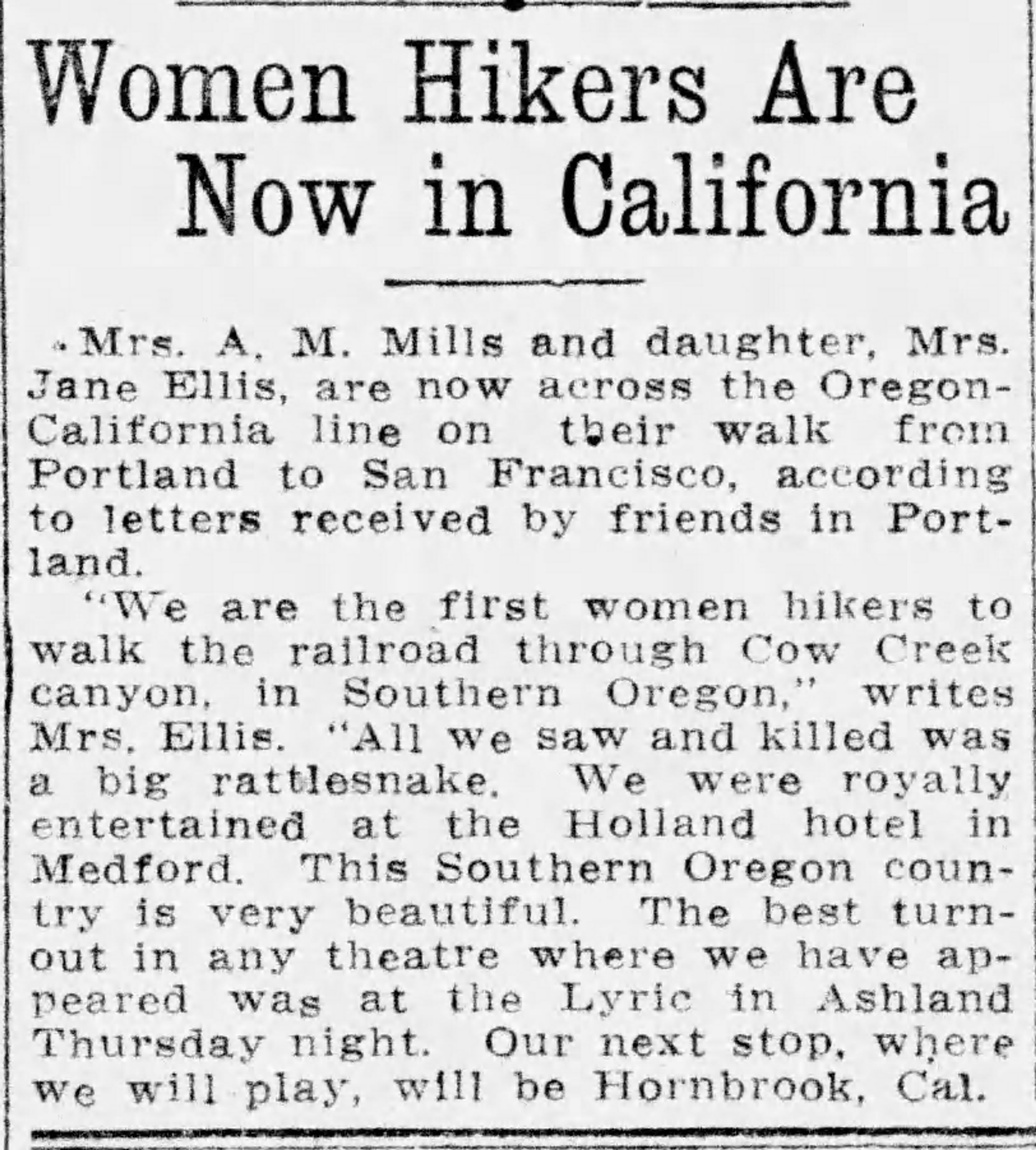
As they neared Douglas County, the Roseburg News-Review tracked their movements: on May 20th musician John Nash and singer Katherine Vernon joined them in Oakland, Oregon north of Roseburg. May 28th they were in Grants Pass. June 1st they passed through Medford, and the paper reported they were navigating by following the telephone lines, hauling their baggage on horseback, and staying in telephone offices whenever they stopped. They seemed to pause for a while in Ashland, giving multiple well-attended performances at the Lyric Theatre.
From Oregon Journal, June 5, 1915
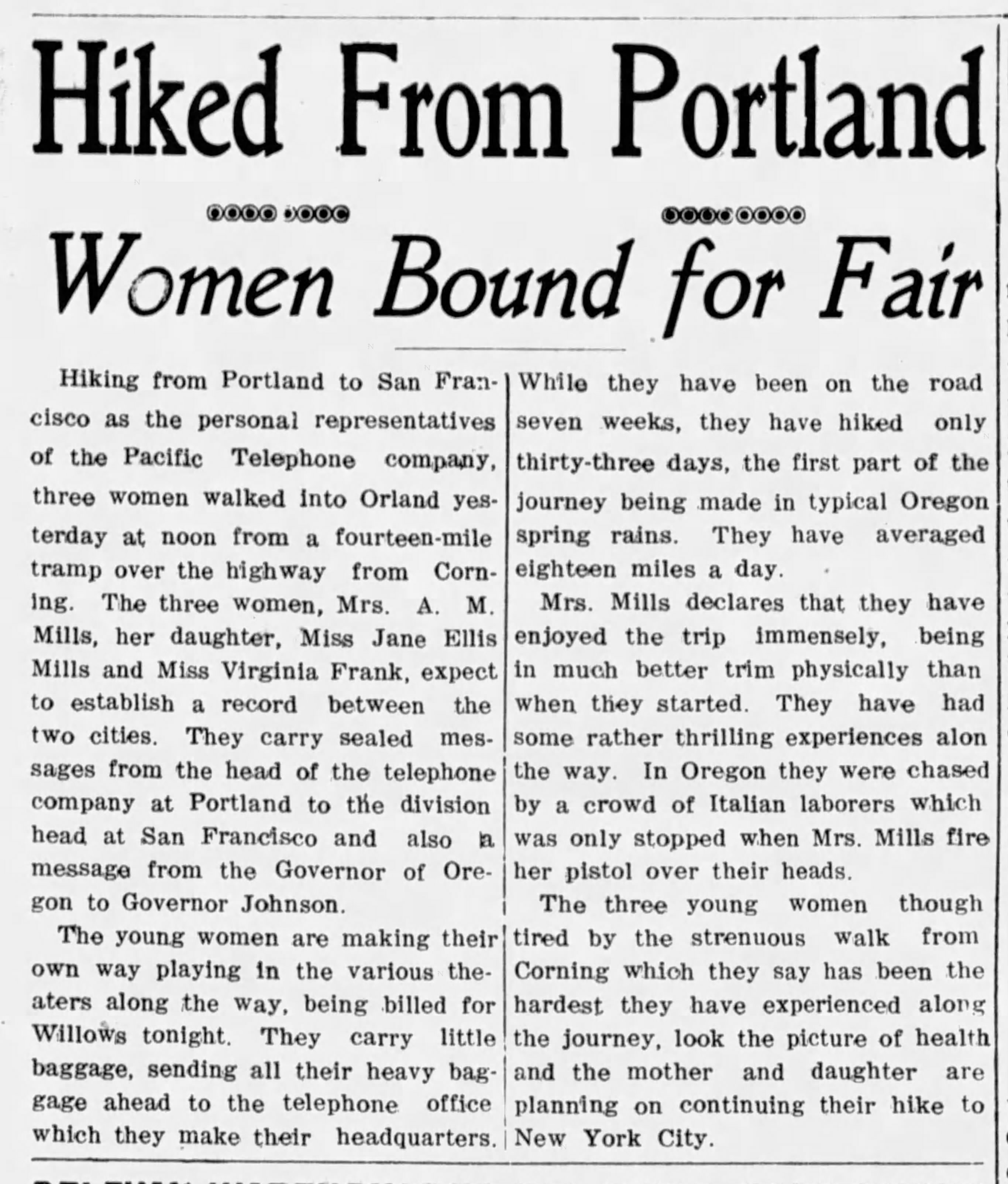
From the Orland, California Register, June 23, 1915
At last, on July 11th, the group—now down to three—arrived in San Francisco. Their stories and a photo—and a sidebar about selling newspapers on the street—appeared on page 4 of the July 12, 1915 San Francisco Bulletin. Click on this for a good read (and look for the Smith & Wesson).
But that’s the last we hear of them, nothing further about going on to San Diego or New York, or any points in between. We’ve had a good look around at newspapers along that way, and there’s nothing. We have to rely on genealogy to give us hints about how their stories end.
They both return to Portland, where daughter Jane marries in 1919, 1923 and 1930, regains custody of her son Wilbur and sets up house with new husband Oscar Severson on SE 17th Avenue, where we find her in the 1930 census working as a debt collector. Living in the house with them is mother Anna, who later dies at home on August 19, 1935 at age 67, and is buried at Lone Fir Cemetery.
In the early 1950s, Jane and Oscar leave Portland to live near her adult son in Los Angeles. One photo of her from those years convey Jane’s character, showing her in red dress and pearls in some snowy pass. Was she retracing the walk?
Source: Ancestry.com
Oscar dies in January 1955 and Jane lives on in Van Nuys until July 6, 1967 when she dies at age 76. Death notices and obituaries don’t remark on the big walk of 1915. But now we know, thanks to a serendipitous morning in the archives, a letter from Mayor Albee, and a photograph of mother and daughter peering into the future.
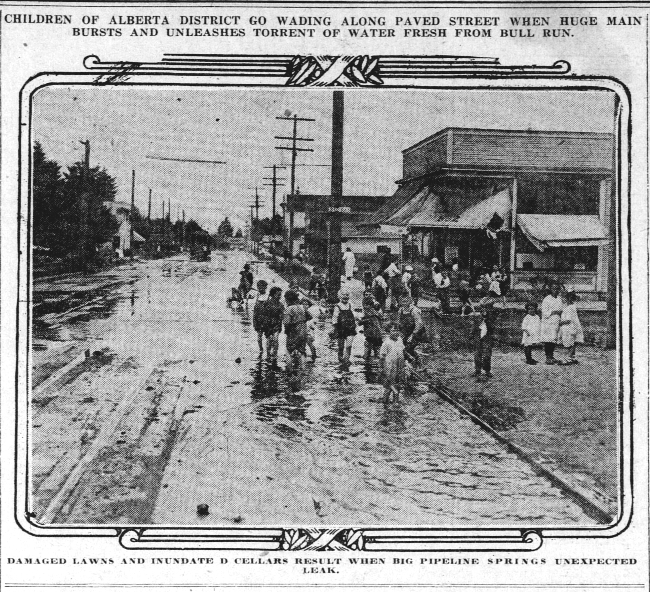
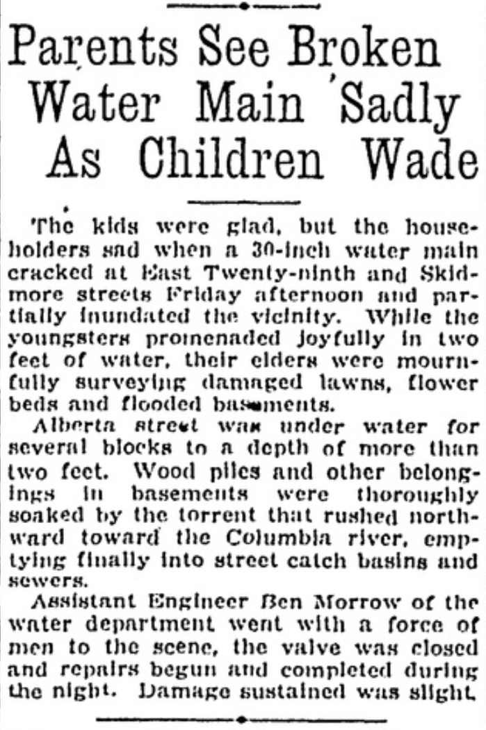
This week we’ve been reflecting on some of the interesting stories from the early history of the Vernon neighborhood, first platted in 1903. AH reader Stephen Peifer asked about the Alberta Street flood of the 1920s, and sure enough echoes of that event can be found in both The Oregonian (our morning paper) and the Oregon Journal (our afternoon paper). Sigh, can you imagine having two major daily newspapers?
Here’s a photograph from The Oregonian, looking east on Alberta at NE 28th, taken on July 24, 1920. A story about the flood, from the Oregon Journal, follows.
This flood story bears a striking resemblance to a similar water main break on March 16, 2019, which we wrote about here on the blog, when a cracked pipe produced a gravel bar near NE 24th and Skidmore (the 30-inch water main runs east west under Skidmore, careful where you step).
We’ve enjoyed re-exploring the Vernon neighborhood this week, preparing for and leading a walking tour to make visible the many invisible layers of history there. Which reminded us of stories we’ve shared here. If you are a newcomer to this blog and haven’t seen these stories, you have some layers of history to sort through.
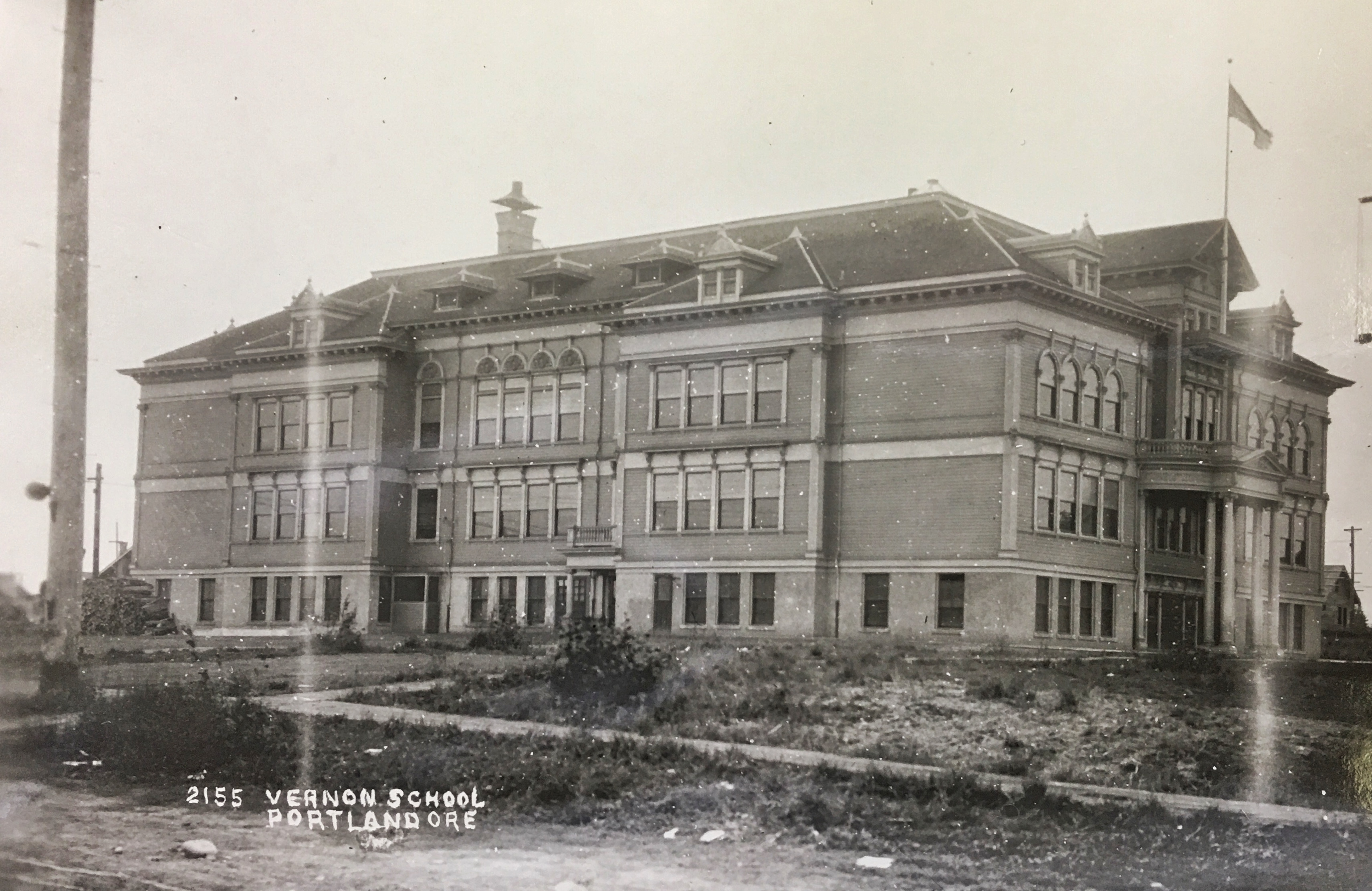
The original Vernon School occupied the entire block from Going to Wygant between NE 22nd and NE 23rd.This view of the school’s south side is looking north-northwest about 1912. The main entrance was on the north side in the center. Photo courtesy of the Oregon Historical Society.
The beautiful ghost of Old Vernon school, which took up the entire block between Wygant, Going, 22nd and 23rd. And the nearby Practice House which literally brought home economics home.
The amazing story of how the city pursued condemnation of property that is today’s Alberta Park.
The neighborhood outcry and organized protest effort in 1958 regarding construction of Fire Station 14 at NE 19th and Killingsworth. Today, we’re glad it’s there, but it wasn’t always that way.
The storefronts of Alberta Street and the tale of the 208 small businesses operating in 1930 between MLK and NE 33rd.
The beautiful little Mildred Hall at NE 23rd and Sumner (formerly the Norwegian Danish Congregational Church).
It’s not too late to sign up for one of the programs we’re doing for the Architectural Heritage Center this summer, kicking off this Saturday morning with a program at AHC focused on Portlanders’ historic connection with the Willamette River.
Saturday, May 10th from 10:00-11:30 we’ll explore the colorful history of Portland’s southeast waterfront in the vicinity of Ross Island, where Portlanders flocked to two hugely popular swimming and waterplay venues: Bundy’s Baths and Windemuth. We’ve written about these here on the blog and will be delivering a program with photos, maps and stories that help bring these former Portland water recreation mainstays back to life. Program based at AHC, 701 SE Grand, Portland.
Vernon Walk – Thursday, June 5th from 6:00-8:00 p.m. we’ll be leading a history walk that explores the Vernon neighborhood, from development of Alberta Park, to the fall and rise of neighborhood schools, to patterns of redlining from the 1930s-1950s, the presence of a dairy, a much-loved synagogue and a street full of small businesses.
Alameda Walk – Wednesday, June 11th from 10:00-Noon This walk through the Alameda neighborhood will include insights about pre-development conditions, planning and construction of the neighborhood, the Broadway Streetcar, home construction and architectural styles and points of local interest including the story behind Deadman’s Hill and the 1920s uproar over the former Alameda Park Community Church.