This week we’ve been reflecting on some of the interesting stories from the early history of the Vernon neighborhood, first platted in 1903. AH reader Stephen Peifer asked about the Alberta Street flood of the 1920s, and sure enough echoes of that event can be found in both The Oregonian (our morning paper) and the Oregon Journal (our afternoon paper). Sigh, can you imagine having two major daily newspapers?
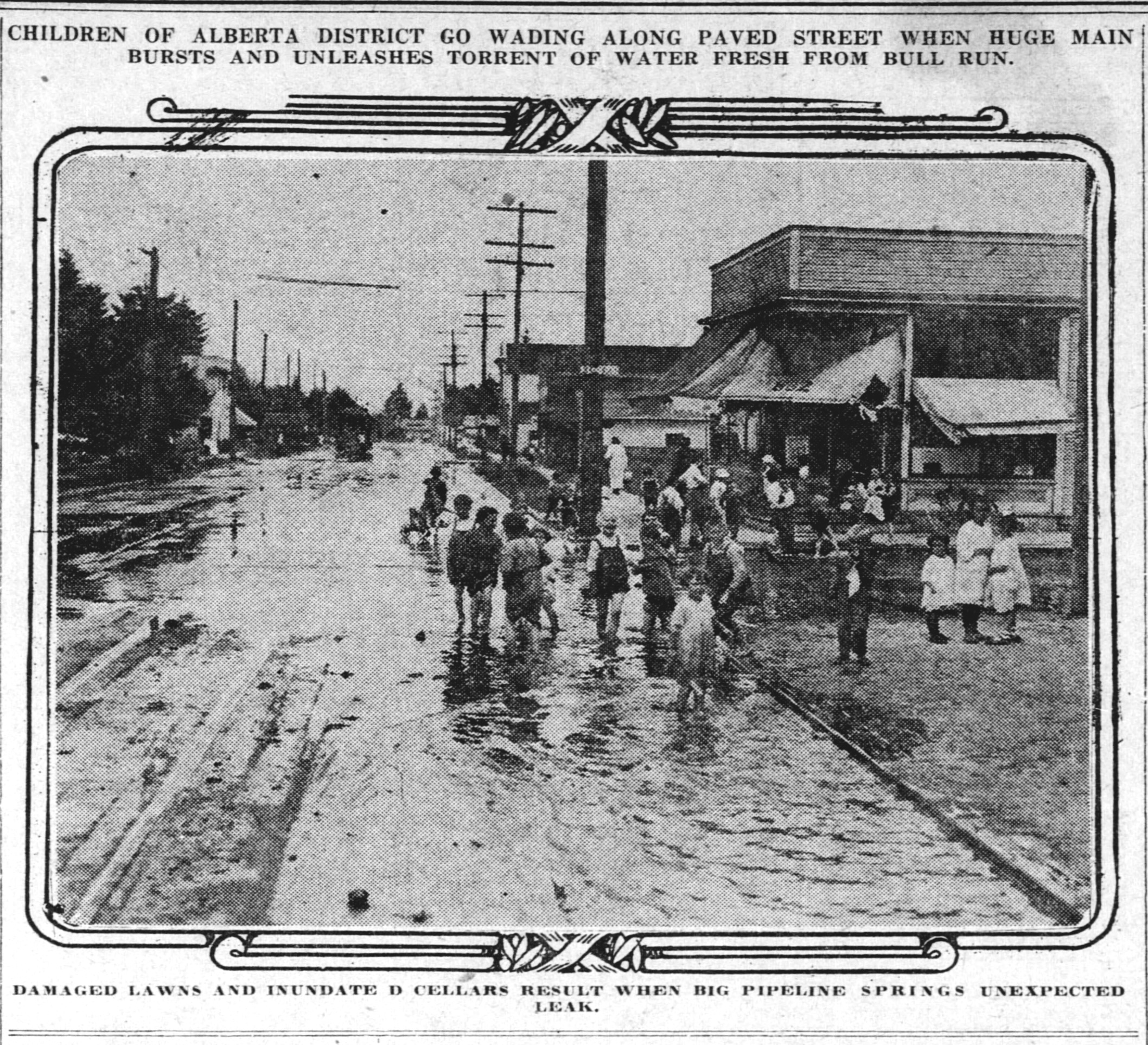
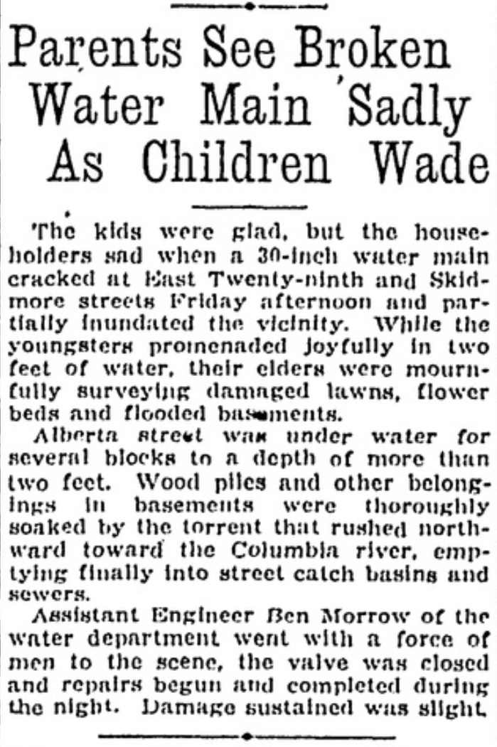
Here’s a photograph from The Oregonian, looking east on Alberta at NE 28th, taken on July 24, 1920. A story about the flood, from the Oregon Journal, follows.
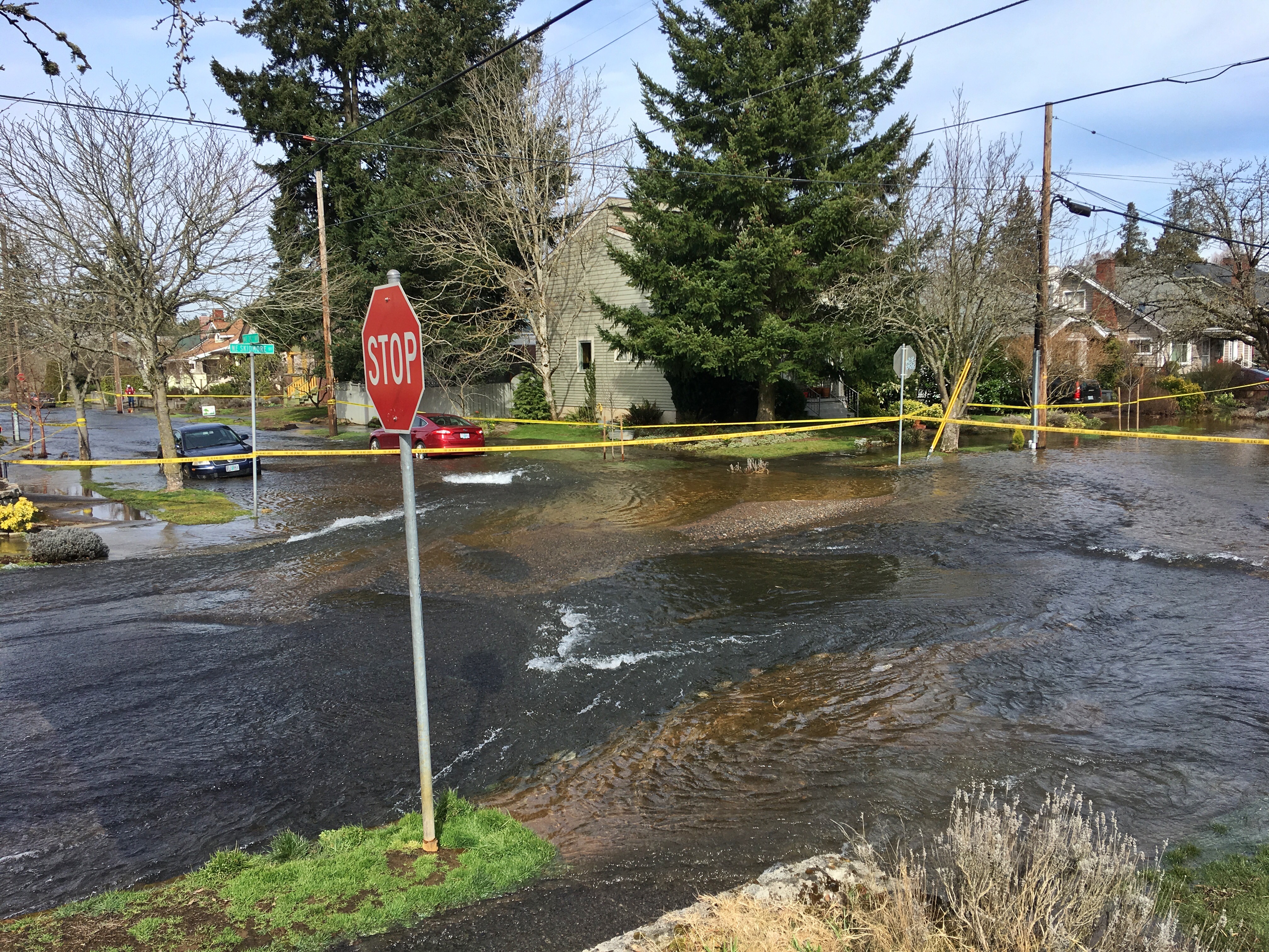
This flood story bears a striking resemblance to a similar water main break on March 16, 2019, which we wrote about here on the blog, when a cracked pipe produced a gravel bar near NE 24th and Skidmore (the 30-inch water main runs east west under Skidmore, careful where you step).
We’ve enjoyed re-exploring the Vernon neighborhood this week, preparing for and leading a walking tour to make visible the many invisible layers of history there. Which reminded us of stories we’ve shared here. If you are a newcomer to this blog and haven’t seen these stories, you have some layers of history to sort through.
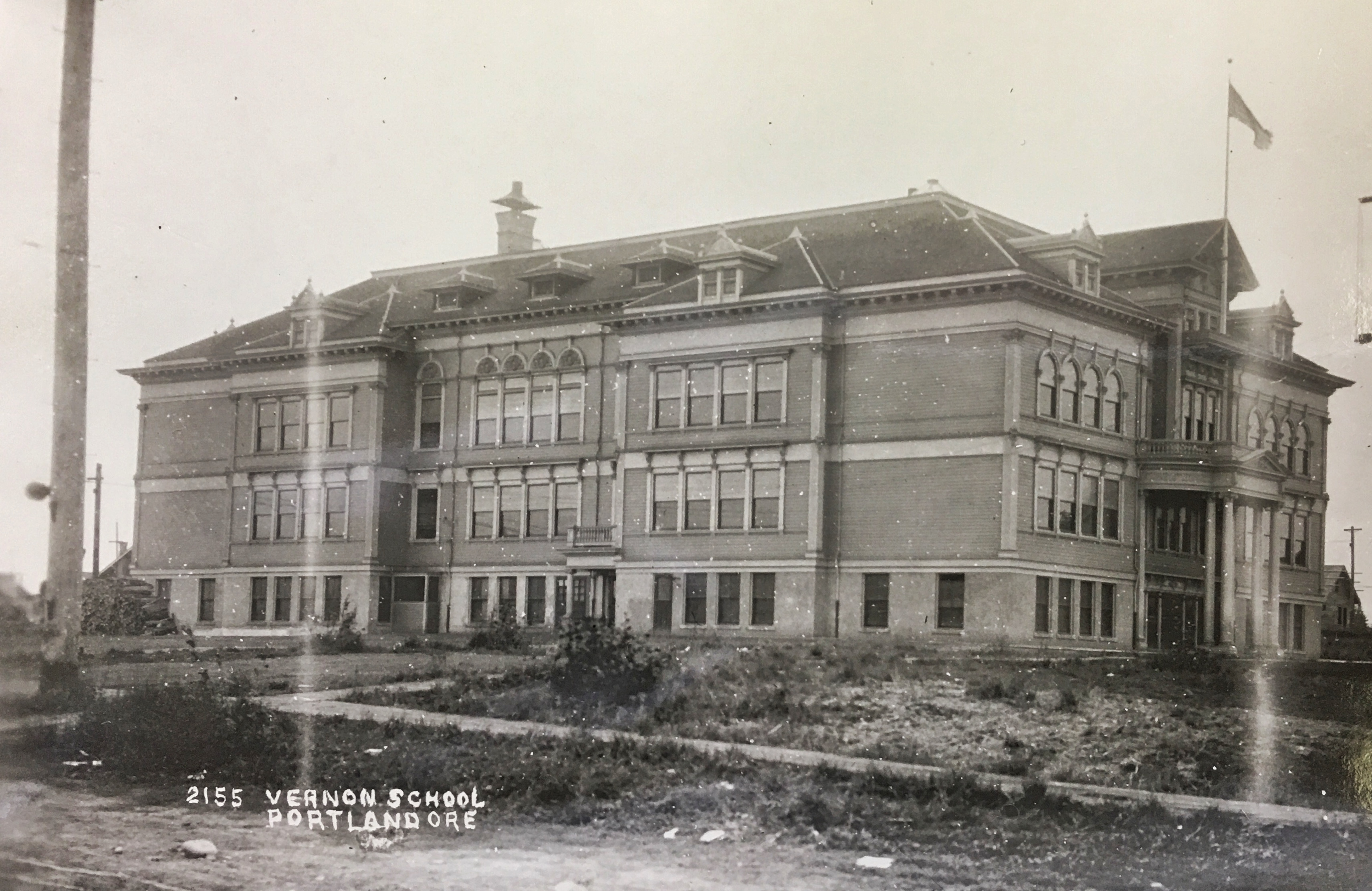
The original Vernon School occupied the entire block from Going to Wygant between NE 22nd and NE 23rd.This view of the school’s south side is looking north-northwest about 1912. The main entrance was on the north side in the center. Photo courtesy of the Oregon Historical Society.
The beautiful ghost of Old Vernon school, which took up the entire block between Wygant, Going, 22nd and 23rd. And the nearby Practice House which literally brought home economics home.
The amazing story of how the city pursued condemnation of property that is today’s Alberta Park.
The neighborhood outcry and organized protest effort in 1958 regarding construction of Fire Station 14 at NE 19th and Killingsworth. Today, we’re glad it’s there, but it wasn’t always that way.
The storefronts of Alberta Street and the tale of the 208 small businesses operating in 1930 between MLK and NE 33rd.
The beautiful little Mildred Hall at NE 23rd and Sumner (formerly the Norwegian Danish Congregational Church).
It’s not too late to sign up for one of the programs we’re doing for the Architectural Heritage Center this summer, kicking off this Saturday morning with a program at AHC focused on Portlanders’ historic connection with the Willamette River.
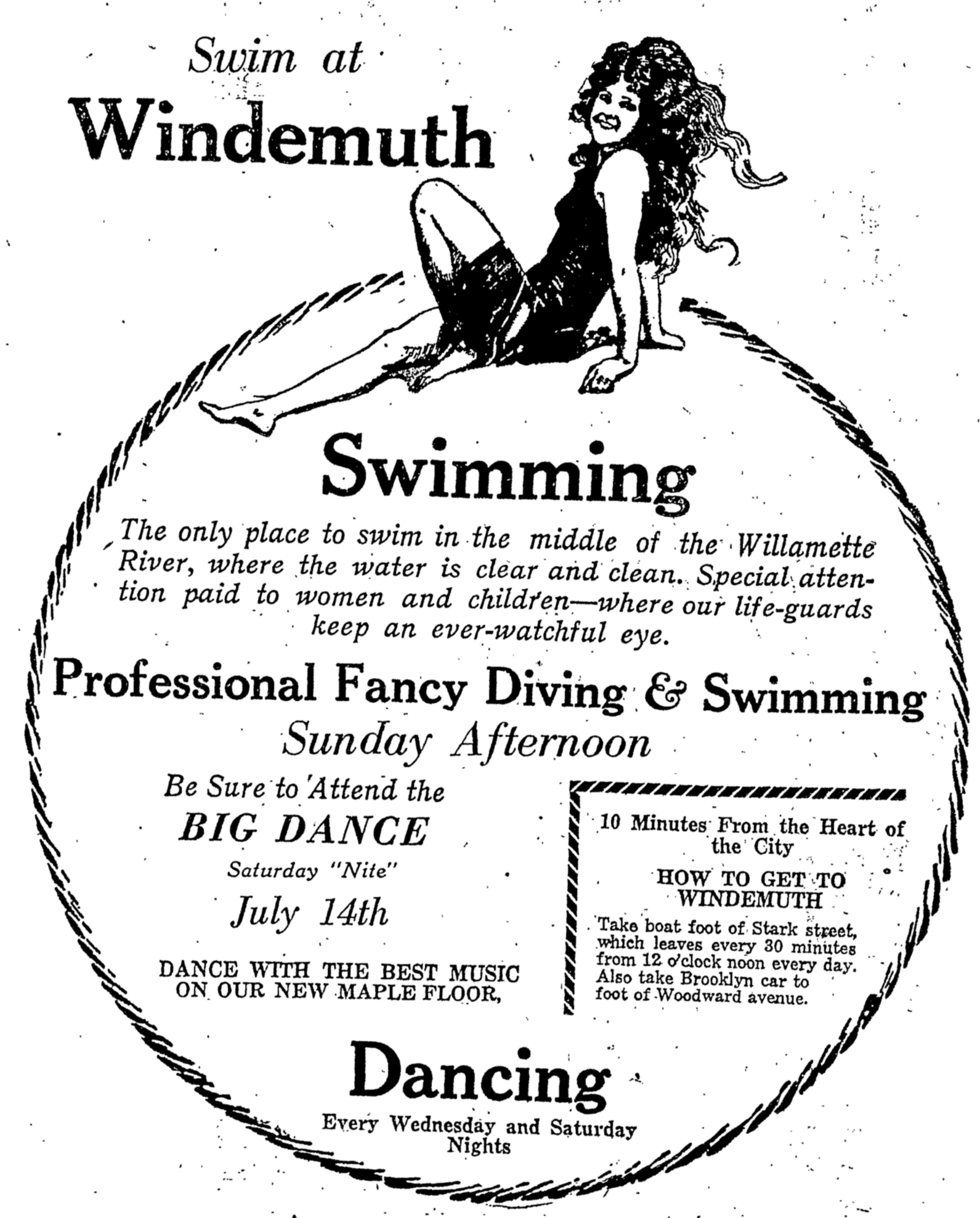
Saturday, May 10th from 10:00-11:30 we’ll explore the colorful history of Portland’s southeast waterfront in the vicinity of Ross Island, where Portlanders flocked to two hugely popular swimming and waterplay venues: Bundy’s Baths and Windemuth. We’ve written about these here on the blog and will be delivering a program with photos, maps and stories that help bring these former Portland water recreation mainstays back to life. Program based at AHC, 701 SE Grand, Portland.
Vernon Walk – Thursday, June 5th from 6:00-8:00 p.m. we’ll be leading a history walk that explores the Vernon neighborhood, from development of Alberta Park, to the fall and rise of neighborhood schools, to patterns of redlining from the 1930s-1950s, the presence of a dairy, a much-loved synagogue and a street full of small businesses.
Alameda Walk – Wednesday, June 11th from 10:00-Noon This walk through the Alameda neighborhood will include insights about pre-development conditions, planning and construction of the neighborhood, the Broadway Streetcar, home construction and architectural styles and points of local interest including the story behind Deadman’s Hill and the 1920s uproar over the former Alameda Park Community Church.
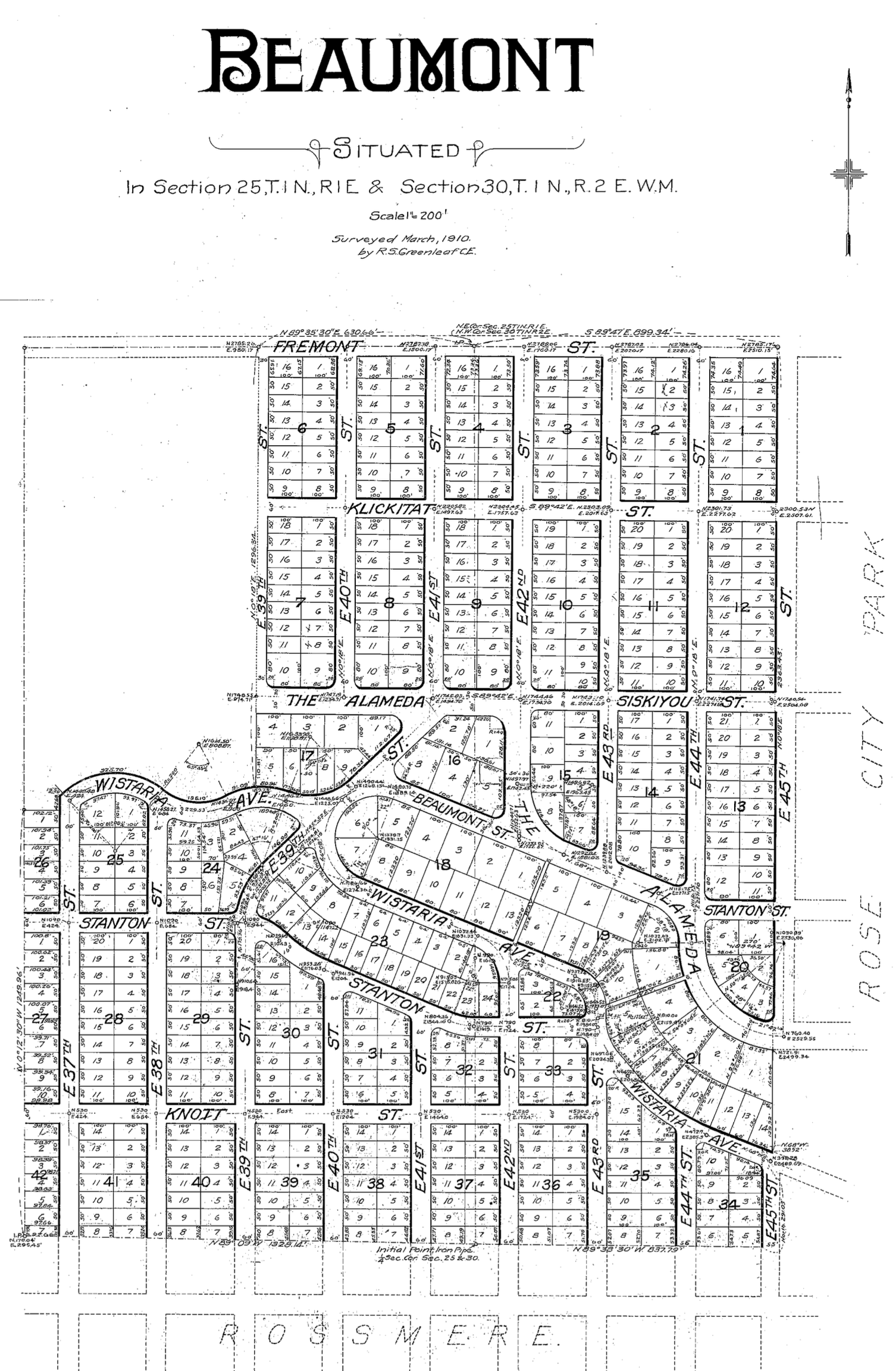
The Beaumont-Wilshire Neighborhood Association is inviting you to an evening presentation about the history and development of this northeast Portland neighborhood: Tuesday, April 1st at 7:00 pm. It’s free and pre-registration is required, which you can do here.
During our 90 minutes together, we’ll have a look back at photos, maps, newspaper articles and memories to create an understanding of the early days of the neighborhood as we look for connections between past and present. We’ll also examine the early forces that shaped Portland’s eastside and the excitement and boosterism associated with Beaumont subdivision’s big opening 115 years ago this month.
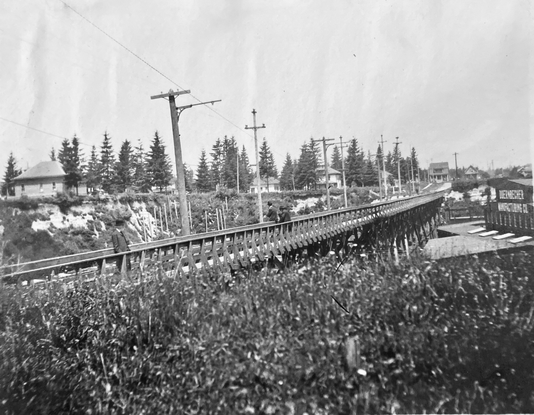
A friendly reader has shared a photograph from her great-grandparents’ photo album and wondered about where it was taken, when, and what it depicts. We love a good photo detective mystery like this, which enables a deep dive back into the landscape of the 1900s. Have a good look at it for detail, and then we’ll discuss:
Courtesy of Phillips Family Archive
You’re looking north at a newly-completed wooden streetcar and pedestrian trestle bridge over Sullivan’s Gulch (where today’s Banfield / I-84 runs) at about NE 28th Avenue, just south of today’s Hollywood West Fred Meyer. The trestle existed for only a short time–from 1903 to 1908–before pressures from a growing Portland replaced it with a concrete span, which was later echoed by new bridges at NE 21st and then at NE 33rd. Its short lifespan says so much about development about this part of the city during the years immediately after the Lewis and Clark Exposition, which ushered in waves of change for Portland.
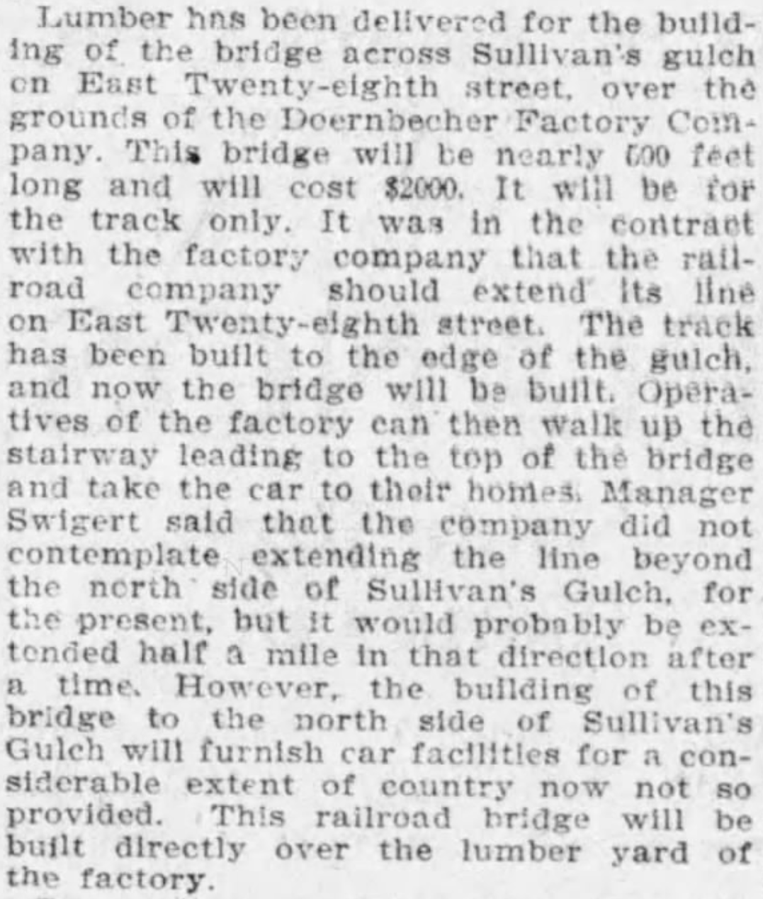
But first, the trestle: 800 feet long, an average height over the ground of 35 feet, costing $2,000 to build, including simply a rail line and a narrow sidewalk on the east side of the span. Built between November 1902 and January 1903 by the City & Suburban Railroad, one of the several streetcar companies that served Portland during those years, later subsumed into the Portland Railway Light and Power Company system.
And here’s where it gets interesting: City & Suburban built the trestle under contract to the Doernbecher Manufacturing Company, a furniture factory, which was Portland’s largest private employer at the time and which operated a sprawling five-acre factory site at the bottom of the gulch just beneath the trestle. Thousands of workers made the trip into and out of the gulch each day and having a means of easy access was helpful for the company, which had opened the factory just a few years earlier in 1899. If you haven’t heard about the factory, you can read more and see photos in this piece, which was the second installment of a series we’ve written on the history of Sullivan’s Gulch. Today’s giant U-Store storage complex is the skeleton of what once was Doernbecher Manufacturing.
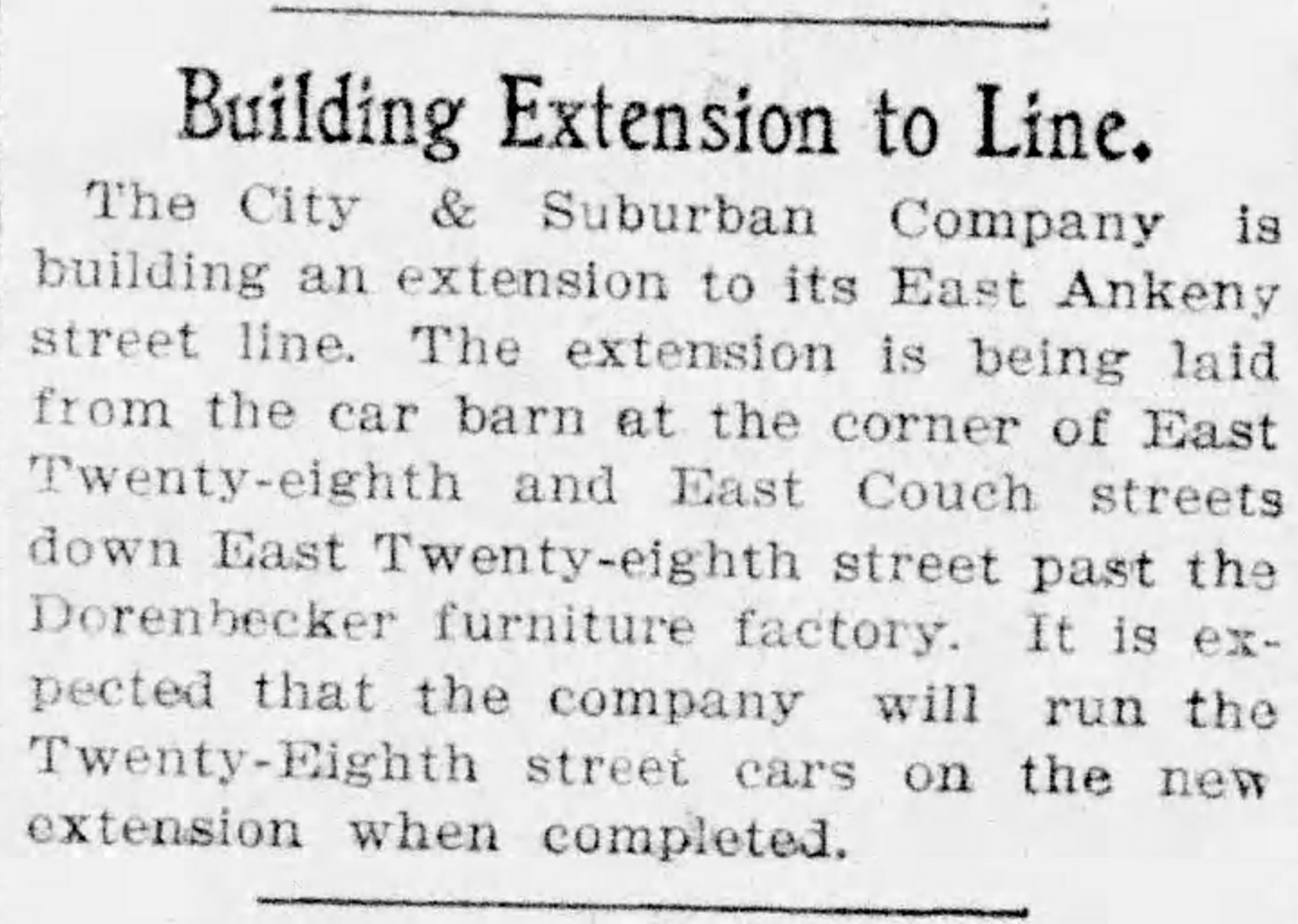
City & Suburban Railroad operated the East Ankeny Line, which terminated in the streetcar barns that once stood near NE 28th and Couch, about a mile due south. For the executives at Doernbecher, it was an obvious proposition to pay the railroad to extend its line north straight up 28th, build the trestle and two prominent stairways down, so workers could come and go conveniently. Meanwhile, City & Suburban was also eyeing service to the neighborhoods taking shape to the north of the gulch, and the possibility of a loop with the existing streetcar service that ran up Broadway into Irvington and later Alameda.
And so it was in August 1902 when construction of the line extension began:
From The Oregon Journal, August 19, 1902
By November, the extension was in and grading was underway at the lip of the gulch to prepare for the trestle. Wood was being stockpiled for construction:
From The Oregonian, November 12, 1902
Trestle construction began in earnest in December and was completed in January. Later that year, the East Ankeny Line was extended a bit farther north to an end-of-the-line stop at NE 28th and Halsey. The envisioned loop with the Broadway Streetcar never materialized.
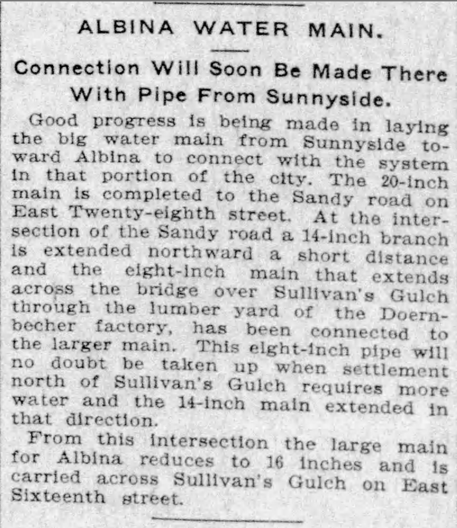
The trestle enabled a broader infrastructure that began to serve middle Northeast Portland. In November 1903, an 8-inch water main was secured to the wooden structure carrying public water for the first time into this part of the city:
From The Oregonian, November 5, 1903
In 1907, following the Lewis and Clark Exposition and with home construction and residential land speculation fever running high, residents of the area began to lobby for a wider multi-use crossing of the gulch in this area. The trestle was replaced in 1909 by construction of a concrete viaduct.
The story of sleuthing the photograph is interesting too:
We knew the Doernbecher story in this location, and could see the “Doernbecher Manufacturing Company” painted on the side of the building in the photo. The alignment of the Doernbecher building, slightly angled to the crossing, is still evident today in what may well be the very same building.
The homes pictured at the edge of the gulch, several of which are still standing today along NE Wasco and Multnomah streets, provide a tell-tale indicator this view looks north.
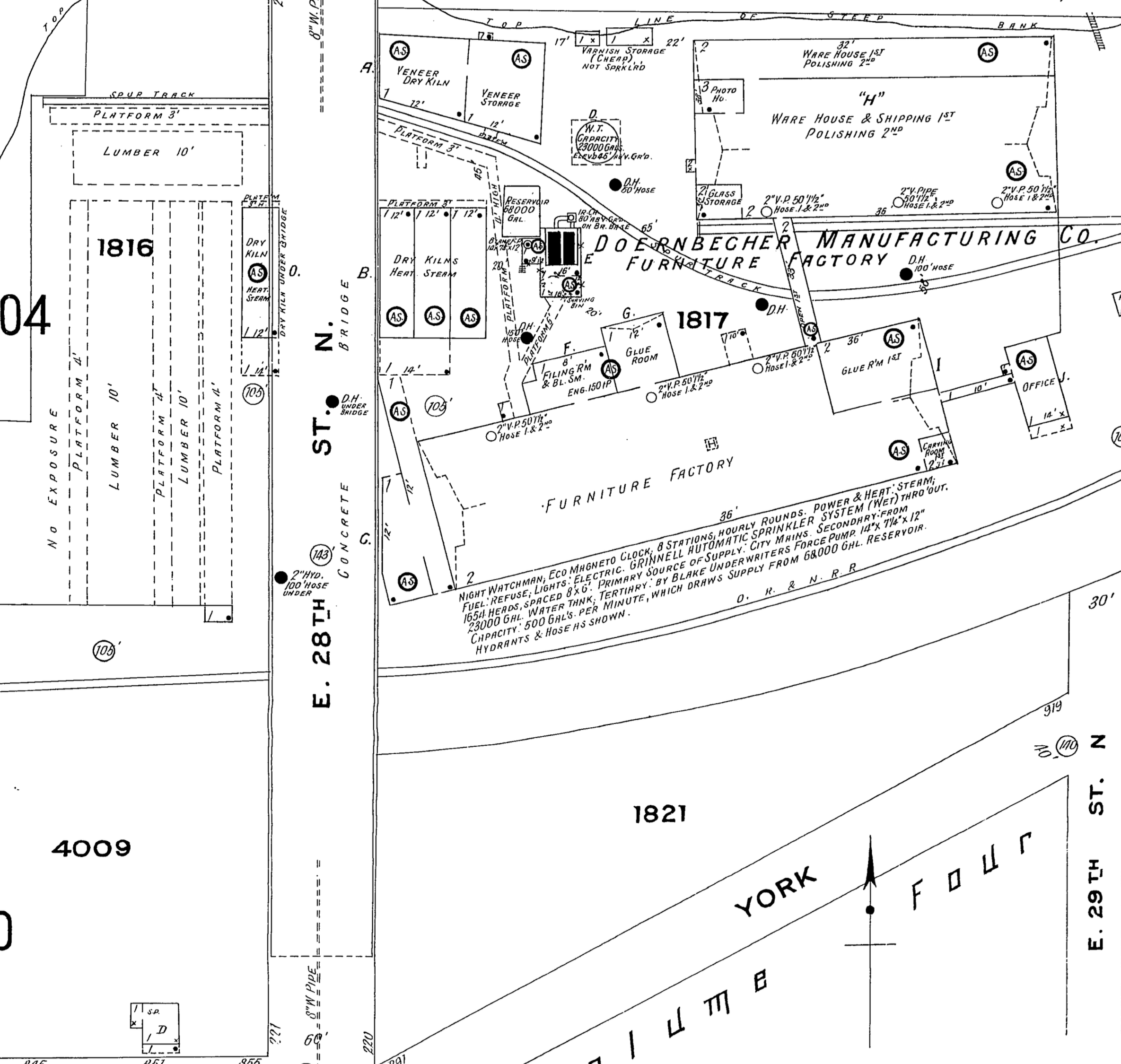
The Sanborn Fire Insurance Map from 1909 also helped, lining up nicely with the Doernbecher lumberyard seen in the old photo through the rungs of the trestle railing and mentioned in the news stories. Knowing the buildings were to the right (upgulch) and the lumber yard was to the left (downgulch) also confirmed direction of the view.
Detail from 1909 Sanborn Fire Insurance map.
The Sanborn also shows the Oregon Railway and Navigation mainline (much later the Union Pacific) which travels through the gulch and was the reason Doernbecher cited the factory there in the first place. The bowler-hatted gentlemen on the trestle walkway are probably looking down as a freight train passed by underneath. Look carefully and you can see the electric and telegraph lines that followed the tracks running perpendicular to the trestle in the mid-ground. The 1909 Sanborn shows the concrete bridge which replaced the trestle.
Do you have old photos you’re trying to make sense of? We’re always glad to help.
In December we discovered and shared here a trove of glass plate negatives taken by a photographer from the Department of Public Works who was out to document the giant gravel pit at NE 33rd and Fremont.
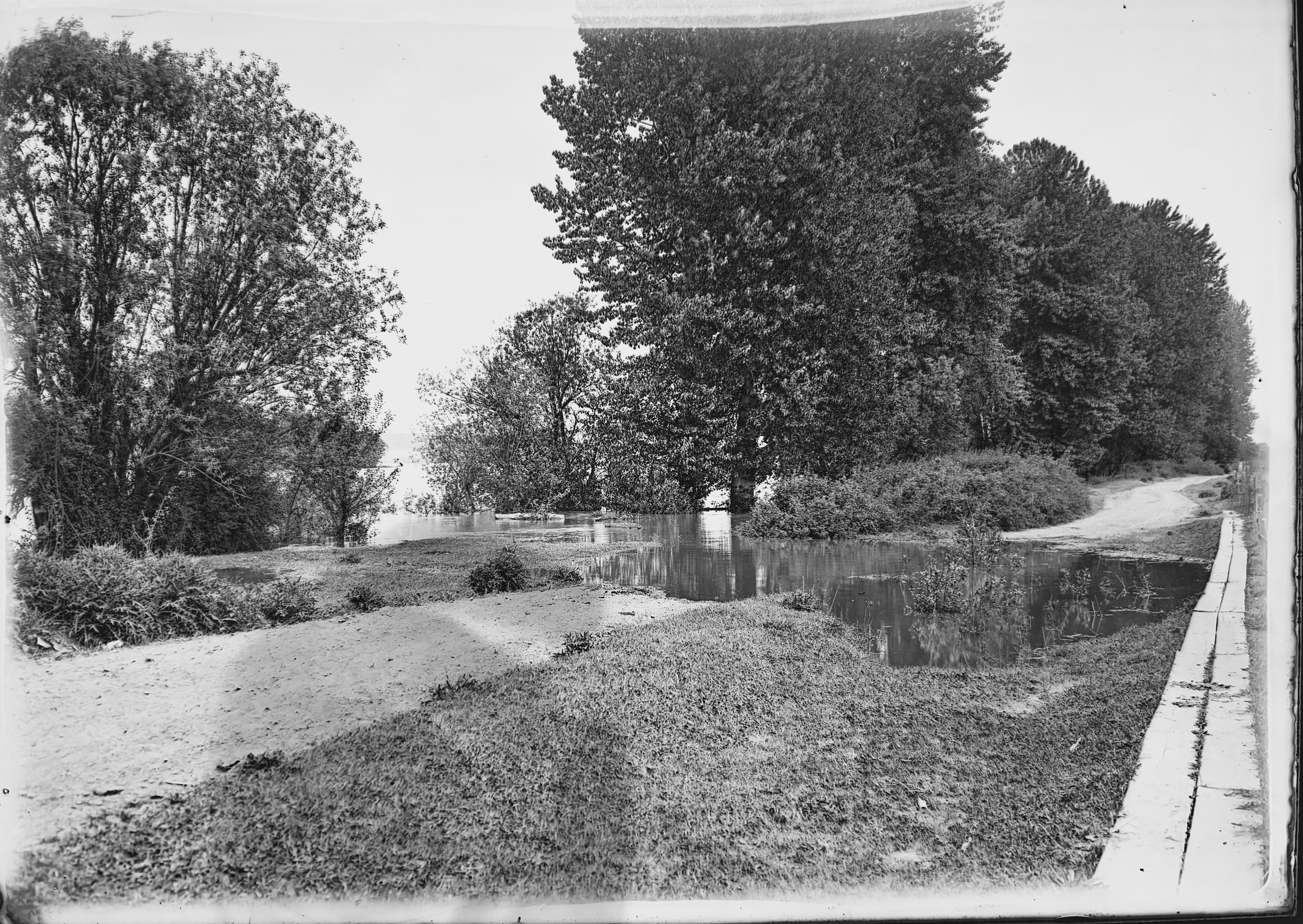
In that same series of glass negatives we found one labeled “High Water Columbia Slough,” clearly shot at a different time of year (the trees are leafed out), but contemporary with other images in that collection from 1911-1913, showing a finger of river overflowing its banks. Trees in the mid-ground are standing in water. A gravel road is inundated, but a plank walkway allows foot passage. Off behind through a curtain of brush is open water, an island in the distance, the far shore in the distance beyond that.
Columbia Slough High Water, courtesy of Portland City Archives. Image A2009.009.2791
We’ve been staring at this photo, like we enjoy doing with all old photos, trying to understand what it has to tell us, where it was taken and its overall context.
We’ve written about the slough here on the blog, also known as the Columbia Bayou on some maps and as “the bottoms” in surveyors notes from the 1850s, and shared some views taken about this time and a bit earlier. In other work, we’ve learned about the conversion of the slough for grazing and agriculture, and later for flood control and irrigation. When this picture was taken, big changes were on the horizon that would eventually lead to a transformation of the Columbia River’s south shore in this area bringing hundreds of thousands of cubic yards of fill, a levee system, construction of the Portland Air Base and later Portland International Airport.
But back in 1913 when this photo was taken there was still living memory of a very different time, of the first people who made their lives and livelihood on these banks, of a river that rose and fell, with waters regularly filling as far south as today’s Columbia Boulevard.
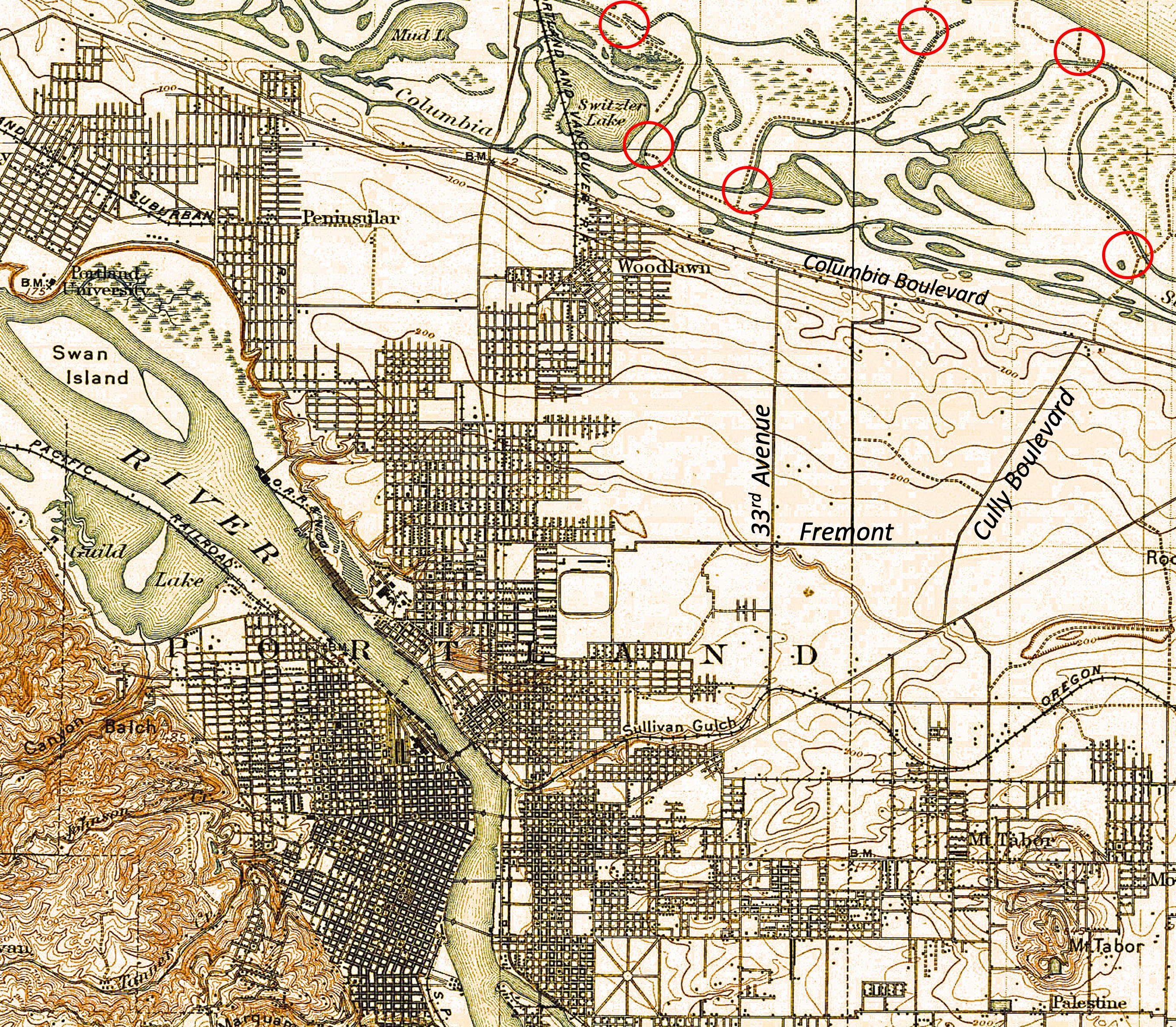
As to where this was taken? Starting with the easy assumptions, we believe it’s looking upstream to the east, the mainstem of the Columbia in the middle distance. The large-format camera used to make this glass negative would have been a heavy thing to lug around, so chances are it’s not too far from where the Public Works Department could drive.
A look at the 1897 USGS Portland quadrangle map above, and the 1915 Hanson and Garrows Map of Portland, suggests it could have been at the far north end of NE 33rd (known in that area as Sunderland Road), or north of Cully Boulevard, both places where small networks of temporary gravel roads wove around slough waters. Check out the map, with some new labels added for orientation and a few possible photo locations circled in red, just for fun. While you’re looking around, appreciate just how complex and amazing the slough was. During high water on the Columbia, all those channels and ponds and the wet meadows in between were submerged.
Back to the 112-year-old photo: it’s a pretty interesting image of an extinct location reminding us of our short time here, and the changes we’ve wrought in just over 100 years.
Here are two more views of the general vicinity taken 25 years later that show us how the slope was settling after being filled with garbage and soil. Photographed by the Public Works Department on November 21, 1938, these views look uphill and downhill on 33rd from just below the top of the hill. Click in for a good look and then we’ll discuss:
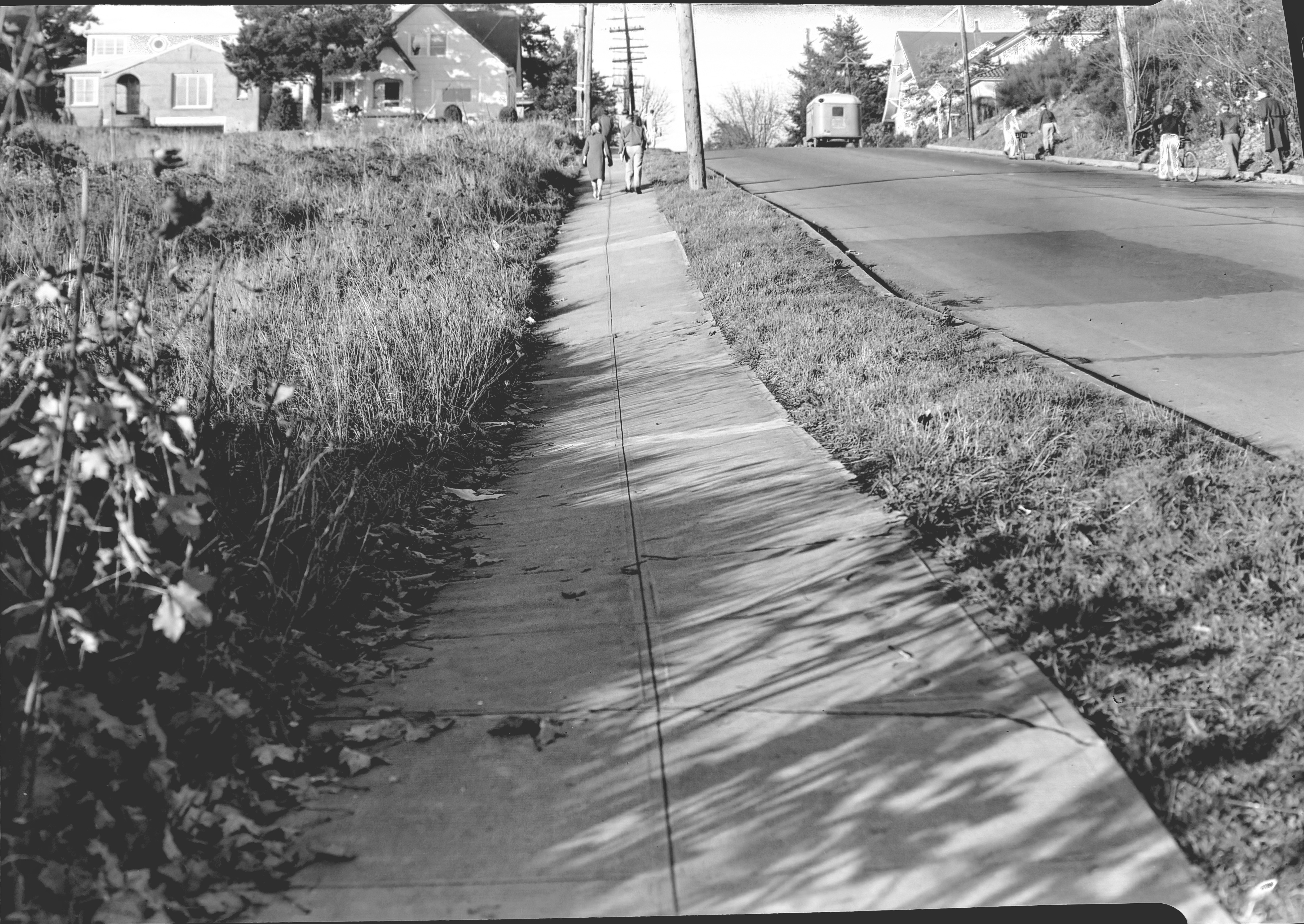
Looking north along the west side of NE 33rd, just downslope from NE Fremont. Image A2009.009.1272, courtesy of City Archives.
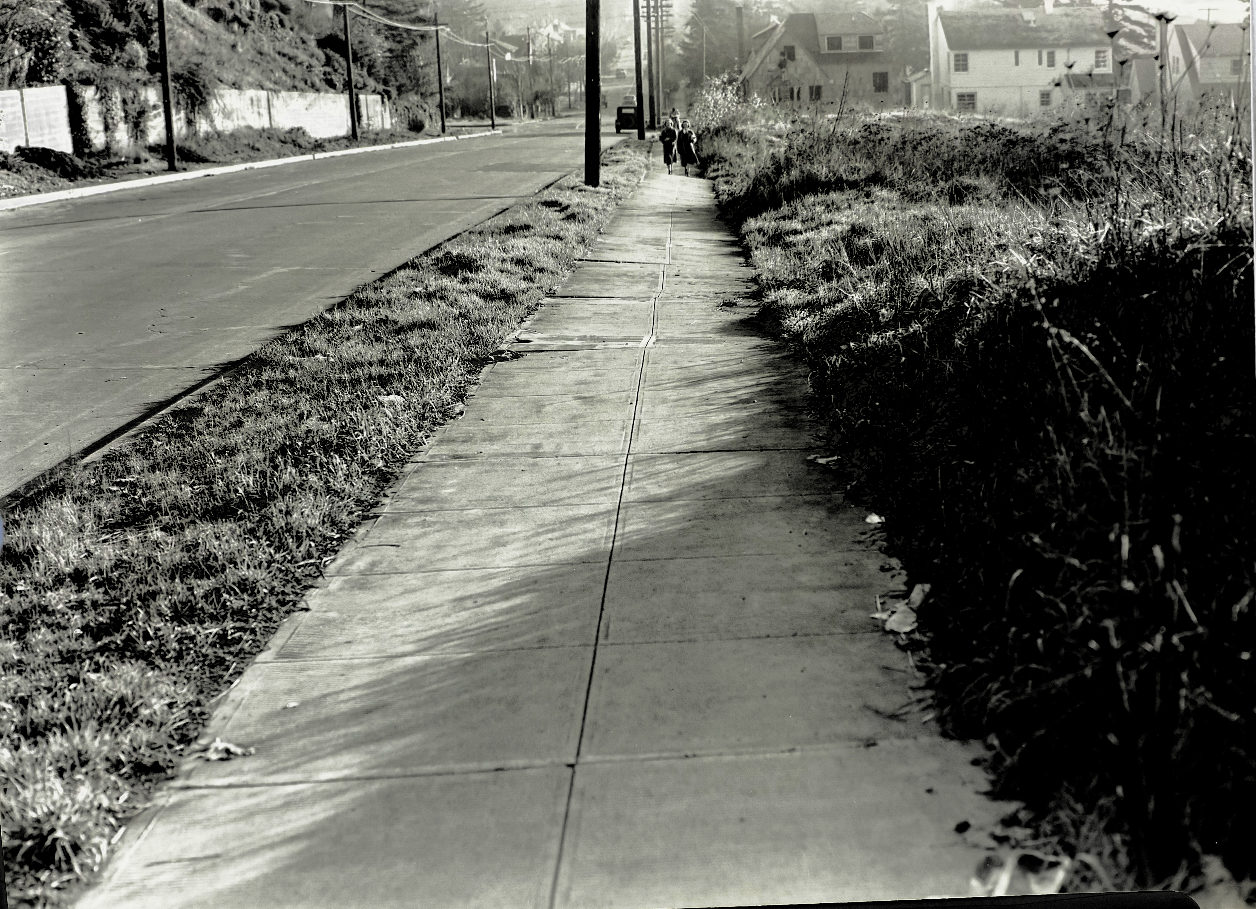
Looking south along the west side of NE 33rd, just downslope from NE Fremont. Image A2009.009.1271, courtesy of City Archives.
Judging by the sunlight and shadows–and what looks like an exodus from Grant High School–these photos were taken in the afternoon of that November day. The uphill photo shows just how much the mid-slope has settled, with the curb and street surface buckling and the entire sidewalk heaving to the west. Nothing has been built on these vacant lots, probably because they were still settling.
Look a bit farther up the hill and you can see two brand-new Ken Birkemeier houses at far left (3279 NE Fremont), perched on what had been the cutbank, and the bungalow to its east at the corner (3289 NE Fremont). Across the street farther east you can see the high-peaked roof of the home at 3304 NE Alameda, and the distinctive tile roof of the Mediterranean-style house at 3301 NE Fremont.
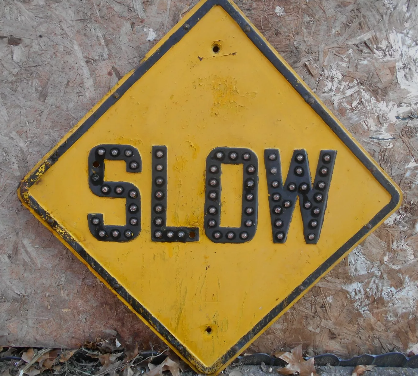
Also interesting to note: no signal light controlling the intersection, nor is there a stop sign facing 33rd (can’t read what is on that sign, but it’s not the standard octagonal STOP sign we know today, which was in common use by 1938). Perhaps Fremont had the stop sign and 33rd had the right of way.
Yet to be built at the top of the hill on the southwest corner was a mid-century home and swimming pool that would eventually collapse into the old pit area and be replaced in the 1990s by a much larger house (and geotechnical engineering). We wrote about it here: The lost house at 33rd and Fremont.
The downhill photo looking south shows just how much the sidewalk wants to fall off into the old pit. Below the pedestrians you can see a house under construction–3289 NE Klickitat, also by Ken Birkemeier who was very busy in this part of the neighborhood during those years.
Today we have Google streetview to document so many aspects of our neighborhood, but it’s been a treat to turn back the clock with these and the 1913 photos. We’re always on the lookout for early photos of our Northeast neighborhoods. Stay tuned for more findings. The promised Columbia Slough photo from 1913 is next.
Post Script:AttentiveReader John Golightly adds his observations that the sign at the intersection probably was a “SLOW” sign, which we agree with. Here’s a photo of a 1930s-era slow sign in its characteristic diamond shape:
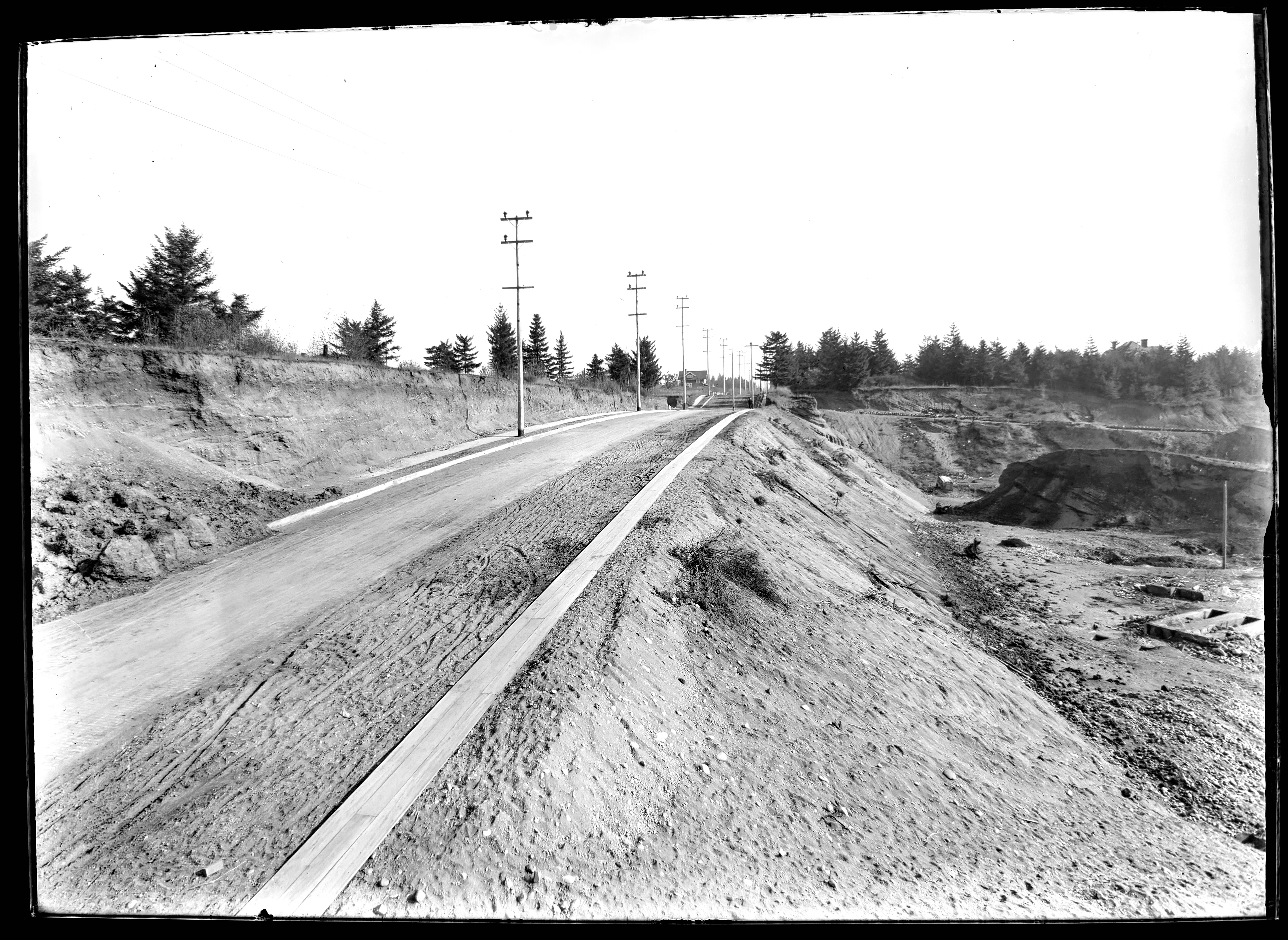
In 1913, nearby property owners and the Department of Public Works were concerned about the stability of the slope above Fremont Street in the stretch between NE 30th and NE 33rd. Fremont itself was perched along the north edge of a giant gravel pit that had been mined for decades and would eventually be filled with garbage to build it back up to grade.
NE Fremont Street looking east near today’s 32nd Place, in 1913. Click in for a closer look. Gravel pit to the right (south) and cutbank above to the left (north). House in the center is 3415 NE Fremont. In the distance, sewer pipe is stacked down the hill along the east side of 33rd and a person faces the photographer at the intersection. A wooden plank sidewalk runs along the south side of Fremont. The gravel and dirt streets were paved the following year. Photo courtesy of City Archives, A2009.009.3615.
The cutbank slope above Fremont angled up 50-75 feet to the southern edges of the brand-new Alameda Park and Olmsted Park subdivisions, which flattened out to the north atop Alameda Ridge. With nothing to hold the cutbank in place, dirt and gravel would periodically slide down, covering sidewalks and curbs and spilling out onto Fremont Street.
A Department of Public Works photographer was there to document the slope. These are the last three in the series we’ve been sharing of re-discovered images at City Archives that are labeled as “Lombard Street.”
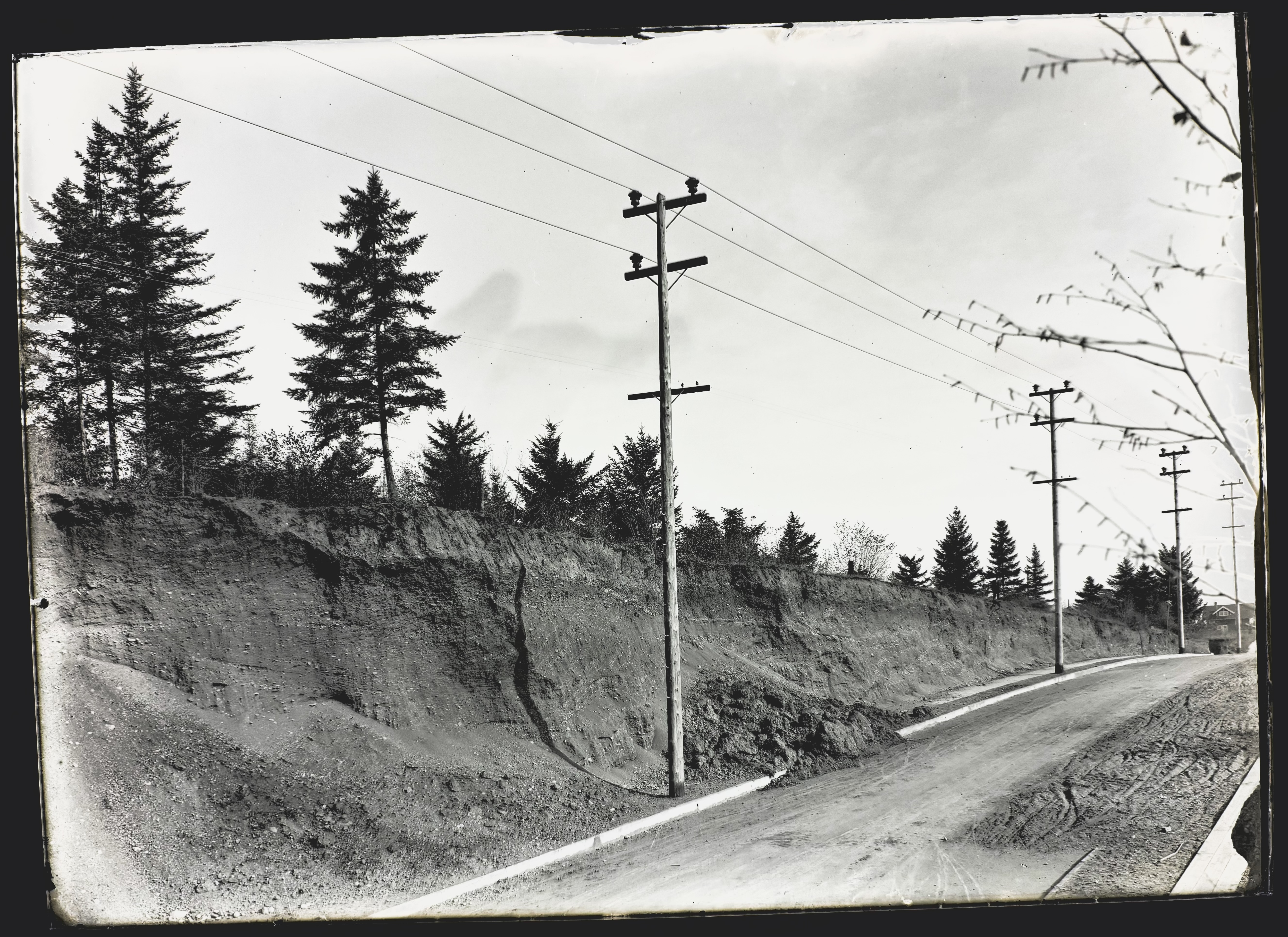
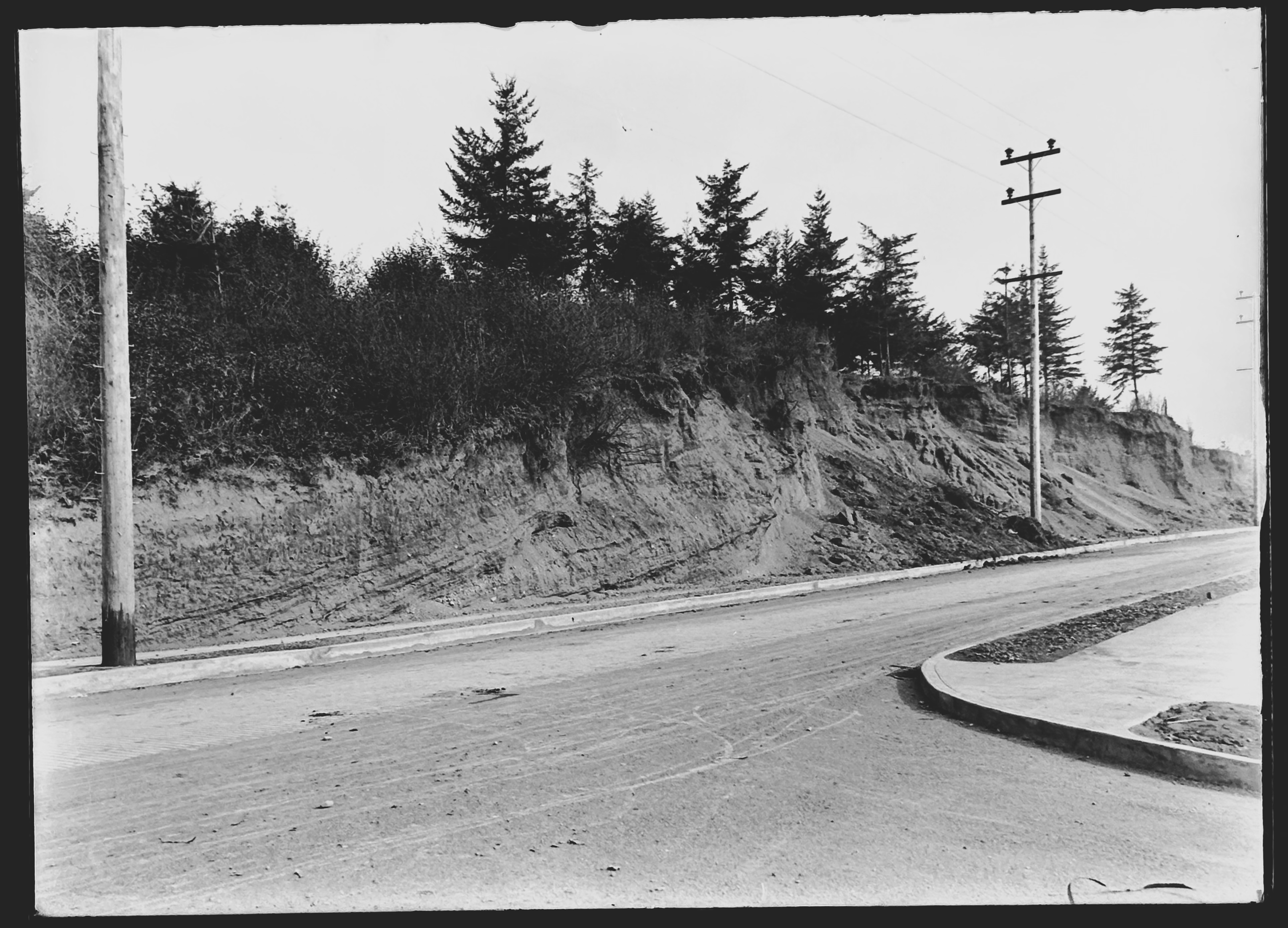
Moving farther west on Fremont, the photographer noted two other slides that had covered sidewalks and curbs.
NE Fremont Street. Looking east just below the crest of Alameda Ridge, seen from between today’s NE 32nd and NE 31st. Photo courtesy of City Archives, A2009.009.3616.
Fremont Street running left and right, seen from the corner of NE 31st, which leads downhill at bottom right. Looking northeast toward the top of Alameda Ridge. Photo courtesy of City Archives, A2009.009.3618.
Be sure to take a look at this view as well, a low-elevation oblique photo from 1930 that shows the cutbank, the slope below Fremont (now filled with garbage and grown over with brush) and lots of other neat things to look at.
No big surprise both slopes were on the move. Geologists remind us Alameda Ridge is basically a giant gravel bar, deposited more than 15,000 years ago by the great Missoula floods that shaped our region. In the years after these photos were taken, vegetation returned to the cutbank slope and houses (and stairways) were built, increasing the surface stability.
Attentive reader and friend of Alameda Brian Rooney tracked down a great graphic that shows the east-west pendant gravel bar of Alameda Ridge that formed downstream (west) of Rocky Butte during the great floods. Helps visualize the old “Gravelly Hill” ridgeline. The arrow points out the intersection of 33rd and Fremont:
A detail from a comprehensive poster explaining the Missoula Floods by the Oregon Department of Geology and Mineral Industries. Thanks Brian!
Up Next – A bonus photo from Public Works: the Columbia Slough in 1913.
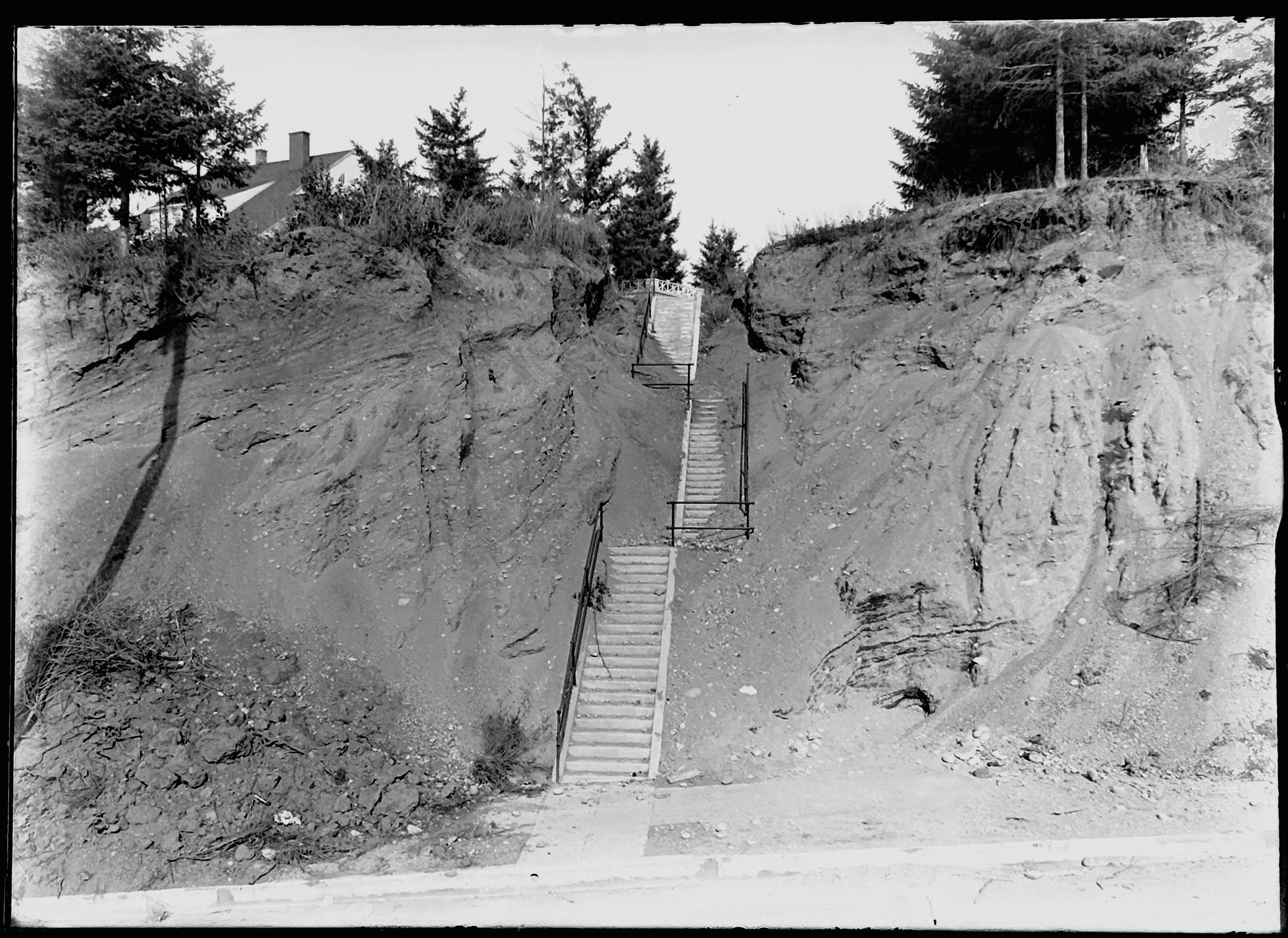
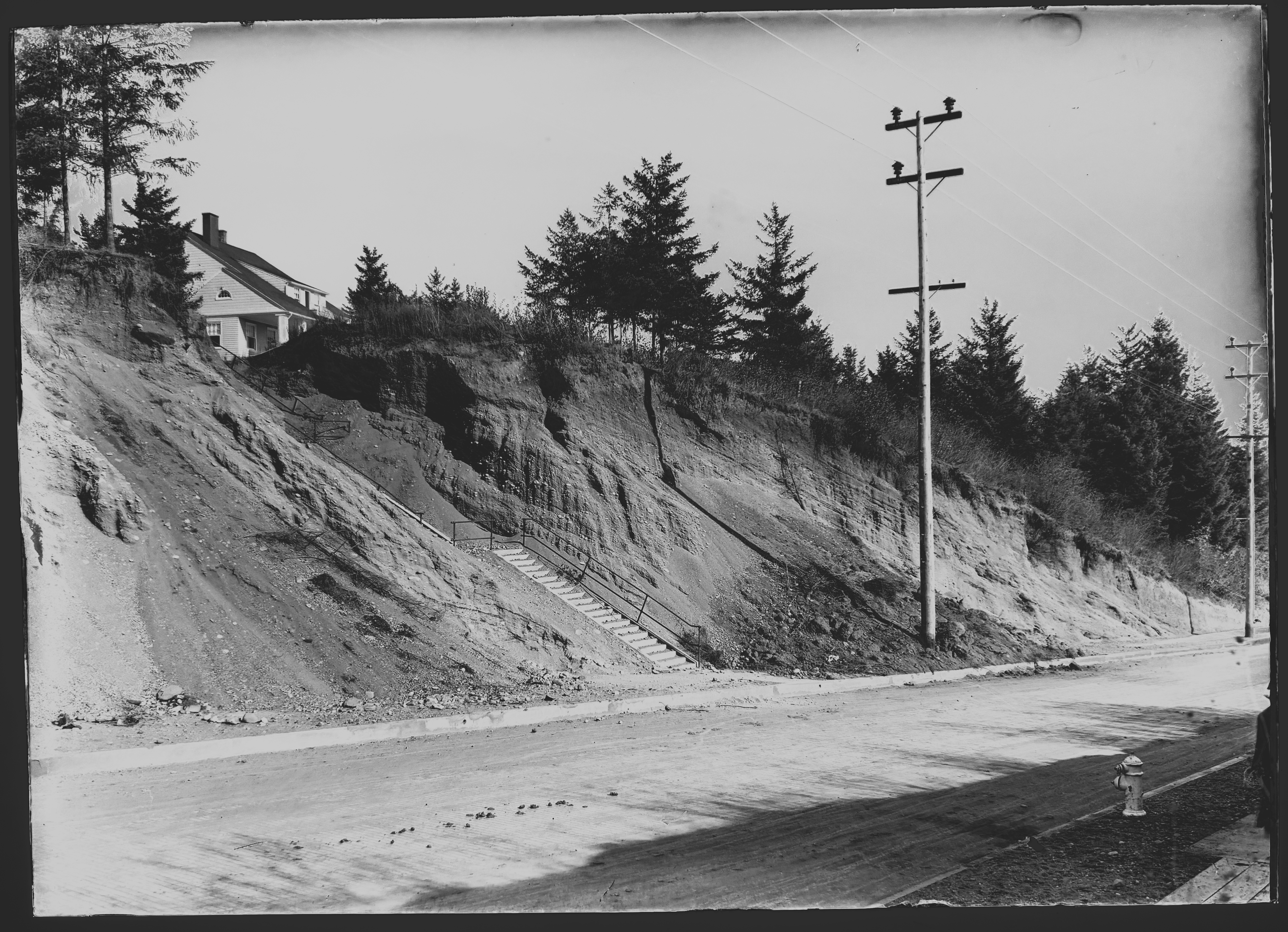
Two 112-year-old public stairways, known today for their role in fitness regimes as well as shortcuts to and from Alameda Elementary School, were once frontrunners of change in what had been rural northeast Portland.
The stairways were built in 1912 by Warren Construction Company, concrete flights anchored into the slope of the ridge, connecting the brand-new Olmsted Park subdivision above with early Fremont Street and what developers hoped would eventually be new neighborhoods below. When built they seemed precarious and tentative, hanging out on rugged cliff-like hillsides above Fremont Street, a giant gravel pit just below. See for yourself:
Fremont Street looking due north showing steps leading down from Alameda Terrace, 1913. House at left is 3251 NE Alameda Terrace. Today these steps land just west of NE 32nd Avenue. Directly behind the photographer was a gravel pit that stretched downslope to the south beyond today’s Klickitat Street and spanned from NE 33rd to NE 31st. Photo courtesy of City Archives: A2009.009.3621.
Fremont Street looking northeast showing steps leading down from Alameda Terrace, 1913. Today these steps land just east of NE 30th and Fremont. House at left is 3251 NE Alameda Terrace. Photo courtesy of City Archives: A2009.009.3635.
A photographer from the Department of Public Works visited the area in December 1913 and may have been following up on concerns from developers and new homeowners about the stability of the slope above and below Fremont in the stretch between NE 30th and NE 33rd. The glass plate negatives he brought back have been at rest since, identified as “Lombard Street” at City Archives. The newly re-discovered stairway images join photos of the giant gravel pit at NE 33rd and Fremont, and photos of the actual intersection in its early development days that we’ve been sharing here, with a few more to come.
The house pictured in both photos still stands today. In 1912, it was one of just a few homes on what was then known as Woodworth Avenue, but is today known as Alameda Terrace, built that same year by Samuel J. and Dorrie Mae Claridge. Over the years, other adjacent houses were built, steadying the slope and giving the stairs purpose connecting neighbors with their neighborhood.
Despite a deep search of early newspapers, city contracting documents and city ordinances, little remains to tell the story of their early construction. When built in 1912, most Portlanders relied on walking and streetcars to get around, and horses to move freight. A dispersed system of public stairways just made sense, particularly up and down landscapes like Gravelly Hill (today’s Alameda Ridge).
The 30th Avenue stairs were noted in the May 1981 citywide Historic Resource Inventory, called out for their significance related to landscape architecture and their role in development of the neighborhood. In the inventory, they’re labeled as “Olmsted Park Public Right of Way.”
Today, these stairs, along with others that span the ridge as it transits northeast Portland, appear in many city exploration guides, including a notable book written by Laura O. Foster called appropriately Portland Stair Walks.
We recommend them as part of your regular history walk regime!
To really understand the next installment of photos from the 1913 collection, it helps to visualize what the middle part of Portland’s eastside looked like then, and what was going on in the economy and life of the city. Following the Lewis and Clark Exposition, which put Portland on the map in so many ways, our population exploded: from 90,426 people in the 1900 census, to 207,214 by 1910.
Like shock waves rippling out across what had been a mostly agricultural landscape, development pressures began to reshape the dirt roads, orchards, dairies and forested clumps of the middle eastside. Meanwhile the economy began to heat up in the early teens as speculators, home buyers and homebuilders jockeyed to take advantage of the growing marketplace. Maps and a few precious photos from the early 1900s show this place as mostly undeveloped open lands, dotted with barns, scattered farm houses and dirt roads.
By 1913, the fields and hills of the middle eastside had been platted out into subdivisions, and the infrastructure of sewer, water, electricity and roads was trying to catch up with the vision sold by developers. In some places, a grid of streets existed, and a sprinkling of single family homes was being built, making visible the conversion from agriculture to residential use. To the north closer to Alberta, construction had been underway since the middle of the 00’s. Eastside neighborhoods closer to the river–Albina, Irvington, Ladd’s Addition, Woodlawn, the Peninsula–had been platted and growing as early as the 1890s.
Back in the day, the intersection of NE 33rd and Fremont–the focal point of this 11-photo series of glass plate negatives from City Archives–was a north-south wagon road to the Columbia River, and access point for the giant gravel pit near the top of the ridge. Surrounded on all sides by planned development, the intersection was in transition from dirt path to thoroughfare.
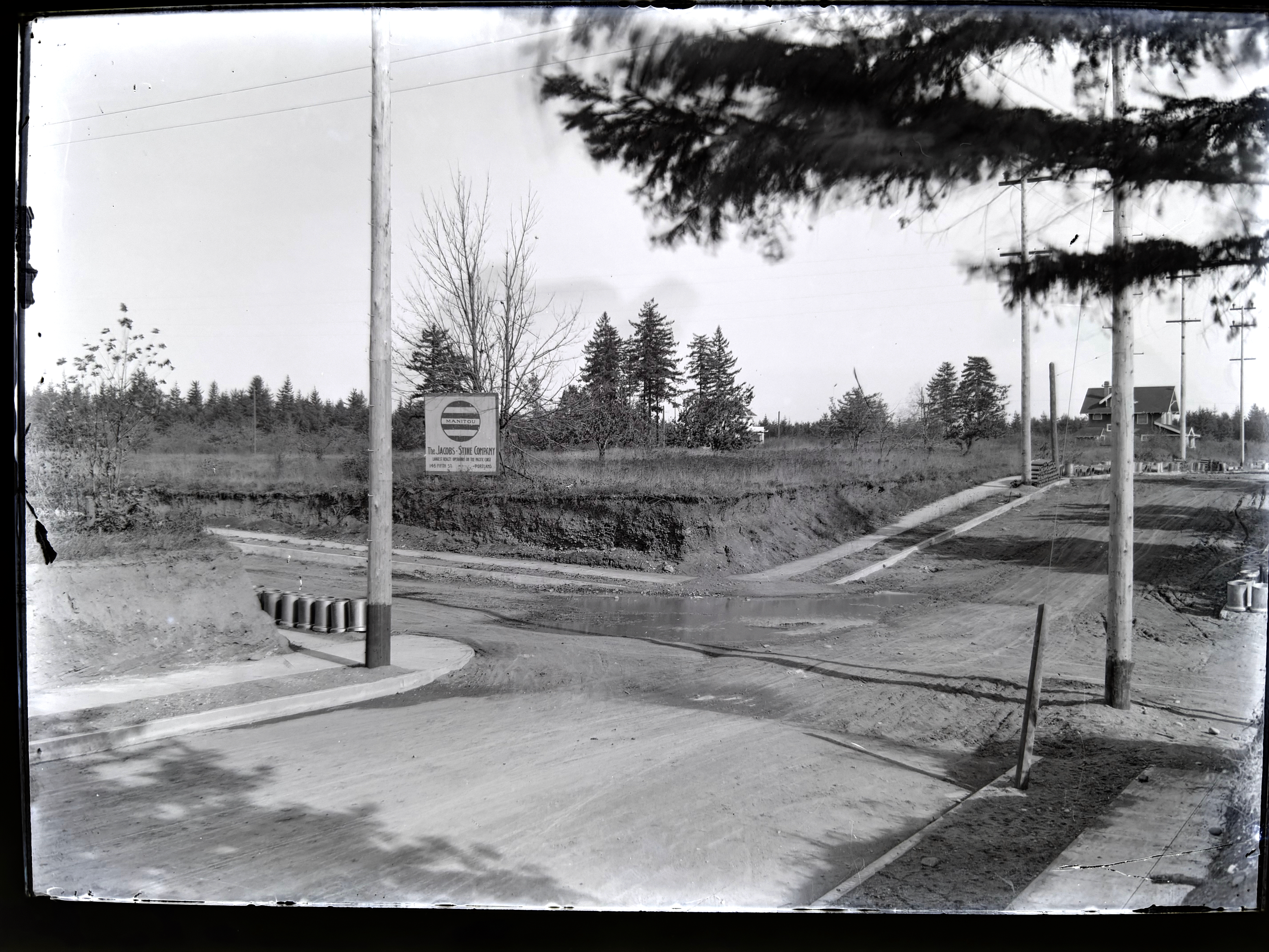
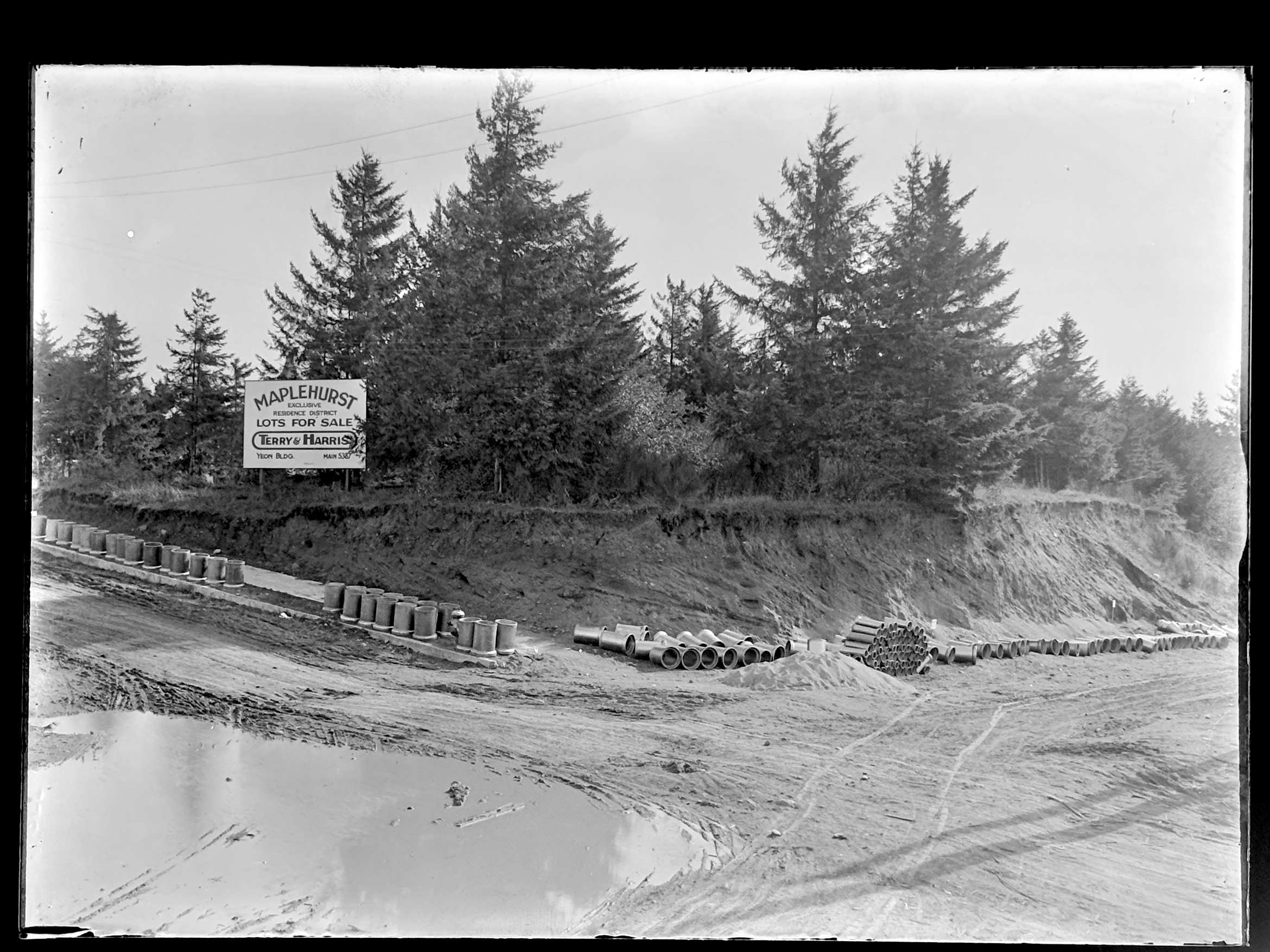
On the northeast side of the intersection, the Jacobs-Stine Company was ready to sell you a lot in the Manitou Subdivision. Just across Fremont to the southeast, the Terry & Harris Company wanted you to see the lots in Maplehurst. Our photographer from the Department of Public Works captured both views. Meanwhile, the mud puddle in the middle of the intersection reminded everyone the reality that for the moment, this was still a fairly rural place.
Looking to the northeast along Fremont from the southwest corner of NE 33rd and Fremont (33rd is passing from upper left to lower right). The house in the distance at right is today’s 3415 NE Fremont (built in 1912). Curbs and sidewalks are in (thanks to Elwood Wiles and Warren Construction), and ceramic sewer pipe is stacked near the curb awaiting installation. The Jacobs-Stine Company, boasting on its sign of being “The largest realty operators on the Pacific Coast,” was owned in part by Fred Jacobs, who would later die when his car tumbled off Stuart Drive in Alameda a few blocks from here, giving rise to the nick-name of that street as Deadman’s Hill. Photo courtesy of City Archives, image A2009.009.3613.
Looking to the southeast from the northwest corner of 33rd and Fremont. 33rd runs down the hill on the right. Fremont follows the slight rise to the left as it heads east. Sewer construction is evidently about to begin. Photo courtesy of City Archives, image A2009.009.3614.
Left photo is similar to top, looking northeast. Right photo is similar to bottom, looking southeast.
Maplehurst was platted in 1910 by Mary Beakey, who named a street for her family (labeled as A Street on the plat). It’s a relatively small subdivision–only three blocks and 43 lots, and exists up against a plat called Irene Heights, which was developed by the Barnes family, containing the Barnes mansion and multiple former Barnes family homes.
NE 33rd wasn’t the only north-south thoroughfare passing through a landscape in transition. One half section to the east (our landscape was gridded into sections, townships and ranges by surveyors in the 1850s), NE 42nd Avenue was experiencing its own growing pains.
Up next: The Alameda stairs. Our Department of Public Works photographer captured the brand-new stairways transiting the slope between Fremont and Alameda Terrace (known as Woodworth before the Great Renumbering of the early 1930s).


