We’ve just completed another builder profile, this time the story of two brothers who formed Hiller Brothers Incorporated in the early 1920s and built more than 400 homes in Irvington, Alameda, Grant Park, Garthwick and West Slope.
A Hiller Brothers built home at 2131 NE Siskiyou, from The Oregonian, March 14, 1926
In the early years, their preferred building type was the bungalow and in later years Tudor-revival and English cottage style. When you figure out the family resemblances, you’ll find them all over the neighborhood. Look for Hiller Brothers’ work on NE Knott Street between 29th and 32nd (virtually every house). They built 40 homes within a two-block radius of NE 32nd and Knott–most designed by Portland architect Hubert A. Williams (1887-1965)–so check out the profile to see a long list of addresses.
James was 16 years older than brother Gus. The two divided up responsibilities, with Gus supervising the construction wing and James focusing on real estate development and sales. In the 1920s, together with their teams of carpenters, tradespeople and sales force, they were among the busiest homebuilders on the eastside. During the Great Depression–like so many other builders–they switched to repair and remodeling work, but that wasn’t enough to sustain the company. Gus eventually went to work in the Portland shipyards and James–after a brief retirement to the Rogue River Valley–returned to Portland to develop hundreds of homes in the West Slope area.
We’ve been exploring the early history of the 1913 Arts and Crafts bungalow at 2503 NE Mason—one of the three we wrote about last week—and the plot has thickened. Its builder, a relocated Canadian citizen, Colorado miner, and livery stable owner, moved to Portland in 1911 and became a home builder, ship builder, all-around handyman and eventually a property developer working on projects in the Hollywood area and near Mt. Hood.
According to building permit and real estate records, Sterling A. Rogers started excavating the basement the very same week he bought the vacant lot in the recently platted Alameda Park addition for $823 in May 1913.
Sterling and wife Lena had arrived in Portland in 1911 after selling their horses, home and livery business in Dunton, Colorado to his brother Robert. Sterling and Lena, then 29 and 26 respectively, had enough of the hard winters in the San Juan Mountains of southwestern Colorado. After a winter escape to the West Coast in 1909, they must have decided it was time to leave. Sterling had been a kind of renaissance man in Dunton, locating mines, constructing buildings, acquiring and looking after horses and wagons.
The Telluride Daily Journal described him like this in its May 23, 1903 edition:
Sterling Rogers, postmaster, merchant, hotel proprietor, and all around monopolist, of Dunton, was an arrival from the south on last evening’s train. He remained overnight and left this morning for Denver. He says that owing to the horrible condition of the roads between the Coke Ovens and Dunton, he cannot get enough lumber to put the finishing touches on his new hotel, but expects to be able to move into the building within the next two or three weeks.
Sterling finished the hotel, and added a pool and baths at the nearby hot springs, but in early 1911 the couple left for Portland. By December, he and Lena were buying vacant lots in the Vernon and Woodlawn neighborhoods. If the hard Colorado winters didn’t drive them out, could be they saw the writing on the wall: by 1919, Dunton had become a deserted and dilapidated ghost town, sidelined by its remoteness and primitive transportation connections, which Sterling knew all too well.
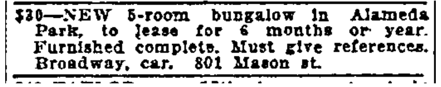
Rogers finished the Mason Street bungalow in August 1913 and advertised it for lease for $30 per month through the fall and early winter while the couple lived there:
From The Oregonian, January 18, 1914
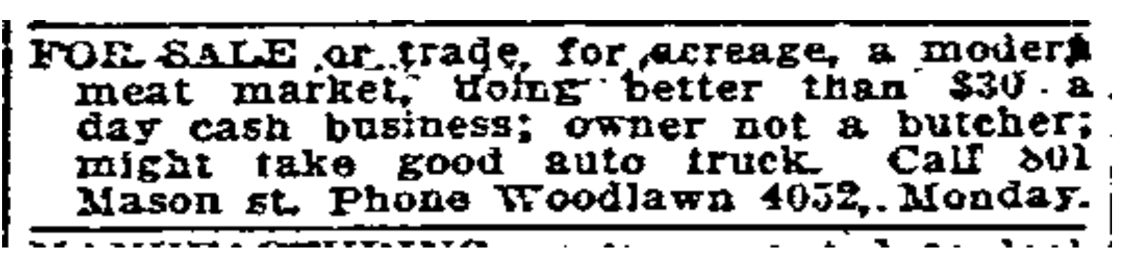
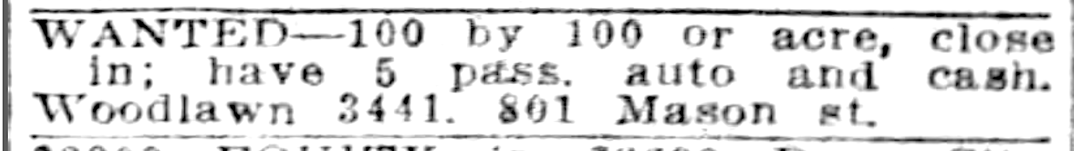
Like many young Portland builders of that time, Sterling was trying to leverage financial momentum by living briefly in his brand-new house built on speculation, leasing or selling it quickly, and using the proceeds to fund other projects that could lead to a next-level income. The couple continued to buy, trade for, and seek additional vacant lots on the eastside. In the spring and summer of 1915, Sterling the entrepreneur was busy:
From The Oregonian, May 9, 1915
From The Oregon Journal, August 8, 1915
Sterling was not a butcher. The meat market had belonged to Daniel and Ethel Dyer, who not coincidentally had moved into the Mason Street house for about a year in 1916, under what must have been a creative financial agreement. But that didn’t last, and by 1917, Sterling and Lena were back. And according to auto registration records, they had indeed been accumulating quite a few vehicles, all registered to the Mason Street house.
In 1918, at age 35, Sterling registered for the World War 1 draft and gave his occupation as a ship carpenter (as well as his height at 5’9”, weight at 140, blue eyes and black hair) and home address as 801 Mason, today’s 2503. That year, he also petitioned for citizenship and renounced his allegiance to George the Fifth, King of the United Kingdom and the British dominions. Rogers had been born in the Canadian province of Prince Edward Island (Canada was then under the dominion of Great Britain). Lena was from South Dakota.
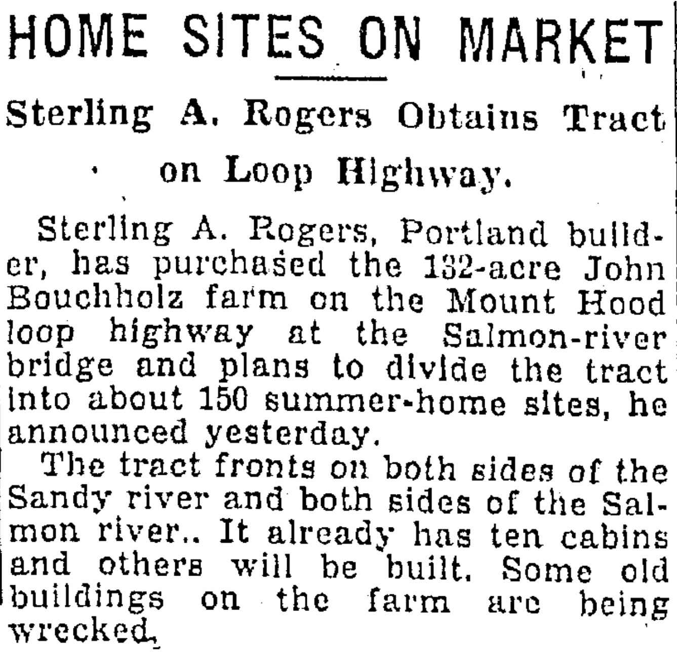
Meanwhile, the couple had been buying property along Sandy Boulevard and by 1920 they moved to a home long since torn down at the northeast corner of 43rd and Sandy. Sterling continued to speculate in real estate, take on repair jobs and build small bungalows—none as distinctive as the Mason Street house. In 1933 it looked like he was going to make it big with a planned development of summer homes on Mt. Hood (which sounds a lot like what is today’s Brightwood).
From The Oregonian, May 21, 1933
But the Great Depression of the early 1930s was a hard time to be building or selling anything. Sterling died of tuberculosis in 1936; his death certificate showed he had struggled with the disease since the mid 19-teens.
Rogers built it – Who designed it?
A look at the handful of relatively non-descript bungalows Sterling built in the 19-teens and 1920s—absent decorative trim, built-ins, columns or beveled glass—makes us think 2503 is a kit home, meaning he bought it as a package to be assembled, which was relatively common then. The design-forward detail of 2503 (see for yourself) is so unlike anything else he built.
So we’ve been poring over kit house and plan set catalogs looking for family resemblances. The external door and window trim is distinctive on this house, as are the three long beveled glass panel interior and exterior doors. Haven’t found it yet, but we’ll keep looking.
Having researched many early home builders, we’re well acquainted with the blend of boot-strap, hard-scrabble entrepreneurship they and their families brought to the building of our neighborhoods.
The homes we live in—the materials they are built with, and the people who did the building—are from a different era that’s hard to imagine today. Each of our homes has its own origin story, the windows, walls and ceilings shaped by people whose stories we’ll never know.
AH readers know walking is the best way to observe the eastside’s century-plus houses and neighborhoods. At a slow pace, you can see the craftsmanship, the years of wear and change, the hands of five or six generations building, improving, maintaining (and sometimes not).
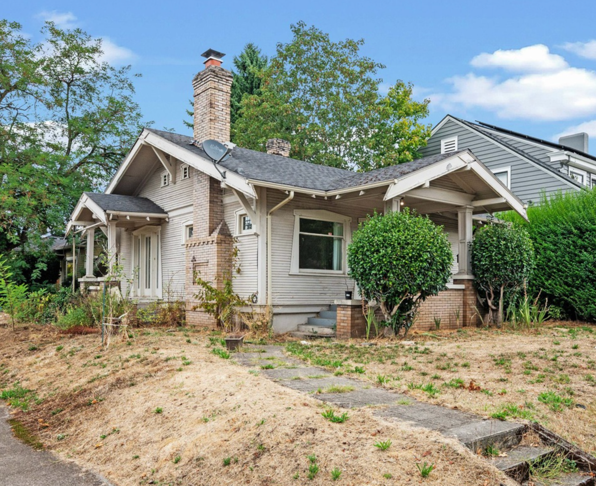
On our regular dog walks this summer, we’ve been watching three particular bungalows on NE Mason in the Alameda neighborhood, just a few blocks apart. All have been time travelers with their own stories and are now in transition. Two of them are essentially gone and no longer in their earlier forms; but one special little one is, at least for now.
1914 Arts and Crafts bungalow at 2503 NE Mason, September 2023.
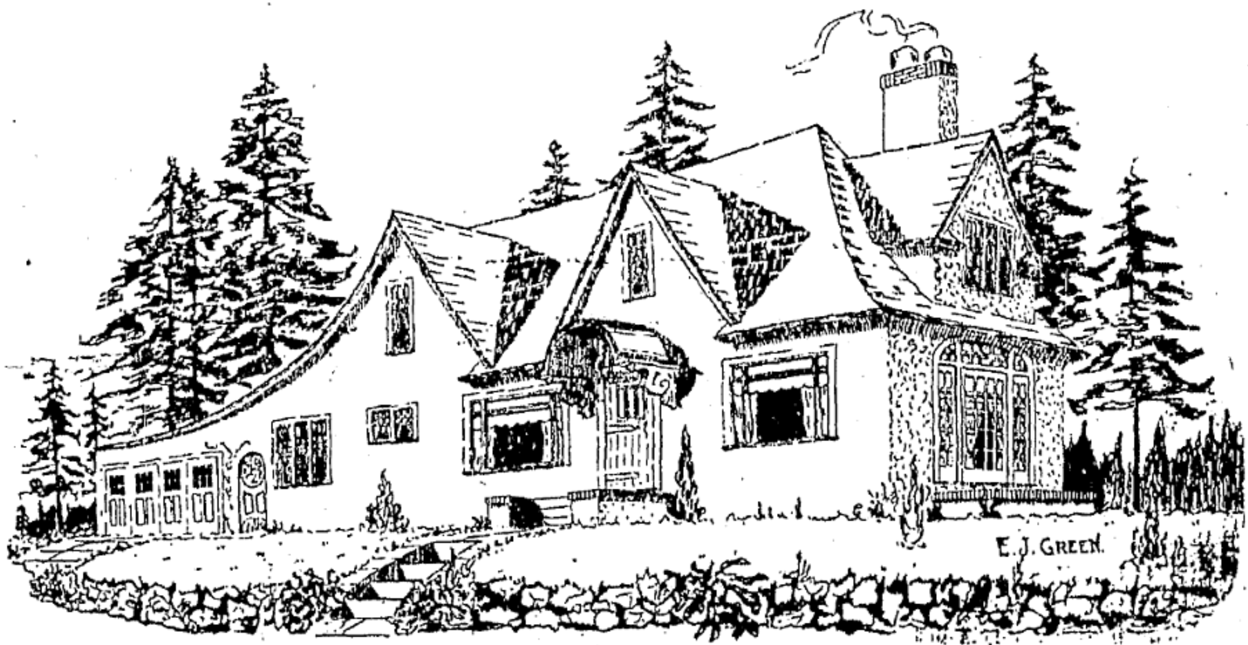
The 1914 Arts and Crafts bungalow on the NE corner of NE 25th and Mason is a small beauty with unique and original trim and detail, both inside and out. You would remember it if you’ve seen it (we’ve never seen a house quite like it). It’s small but distinctive, has been essentially unchanged in almost 110 years, and it’s on the market now, listed by Emily Hetrick at Keller Williams.
Interior of 2503 NE Mason, September 2023. Note the coved ceiling, box beams in both rooms, beveled glass built-ins, beveled glass windows and doors, period decorative columns. Fine 110-year-old architectural detail inside and out.
A few years back, we had the good fortune to connect with family members who remember it from the 1940s and 1950s as the perfect small bungalow. Back in the day, David White remembers visiting his great aunt and uncle who lived there. Here’s a photo of their niece–David’s mother Agnes–at the front porch from 1940. That very same view is very much available today.
Agnes Coulter in 1940, front porch of 2503 NE Mason. Note distinctive window and door trim, still in place today. And of course the smiling subject and her flowers. Courtesy of David White.
David’s grandmother Isabella Coulter ran the Alameda Park Grocery at NE 27th and Going, which we wrote a three-part series about back in 2015. By day, Isabella worked in the store. In later years, after closing time, she returned home a few blocks south to this small corner bungalow she shared with her sister and brother-in-law. Frequently, nieces and grand nephews visited the bungalow and those memories are strong and clear.
Because it is small and because it’s on a corner, we’re a little worried about its future. We’re researching its early history at the moment and will have more to share, and would be glad to introduce the new owners to its long-time-ago former family who knew and loved it well.
A few weeks later we posted the origin story of this great little bungalow, which you can read here.
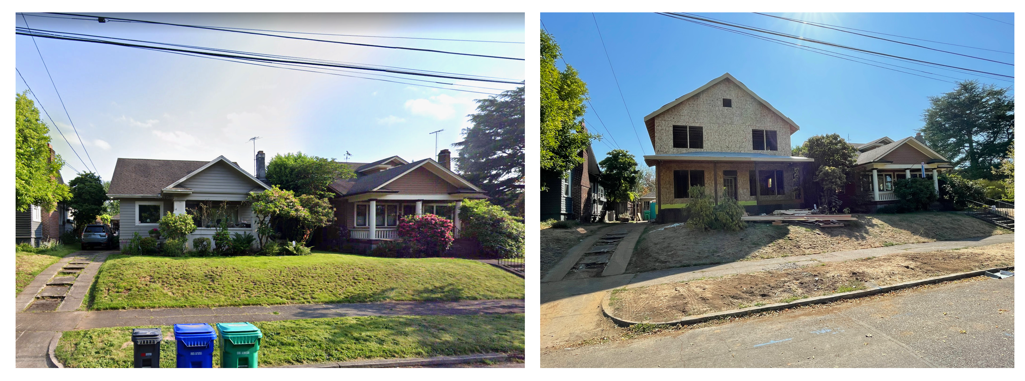
A couple blocks east on the south side of the street was the Clifton bungalow, built in the summer of 1921 by Enoch Clifton, who with his brother Knute immigrated from Norway and went into the homebuilding business on Portland’s eastside, making bungalows just like this one throughout the neighborhood. Their niece Nancy Clifton lived in the home for many years up until her passing earlier this year. The bungalow was bought by Liberty NW Homes in Oregon City and all but razed—the building permit refers to the work as an “addition.”
Here’s a look at before and during.
2617 NE Mason (on the left) before, and this week. The new house utilizes the foundation and several external walls of the former bungalow.
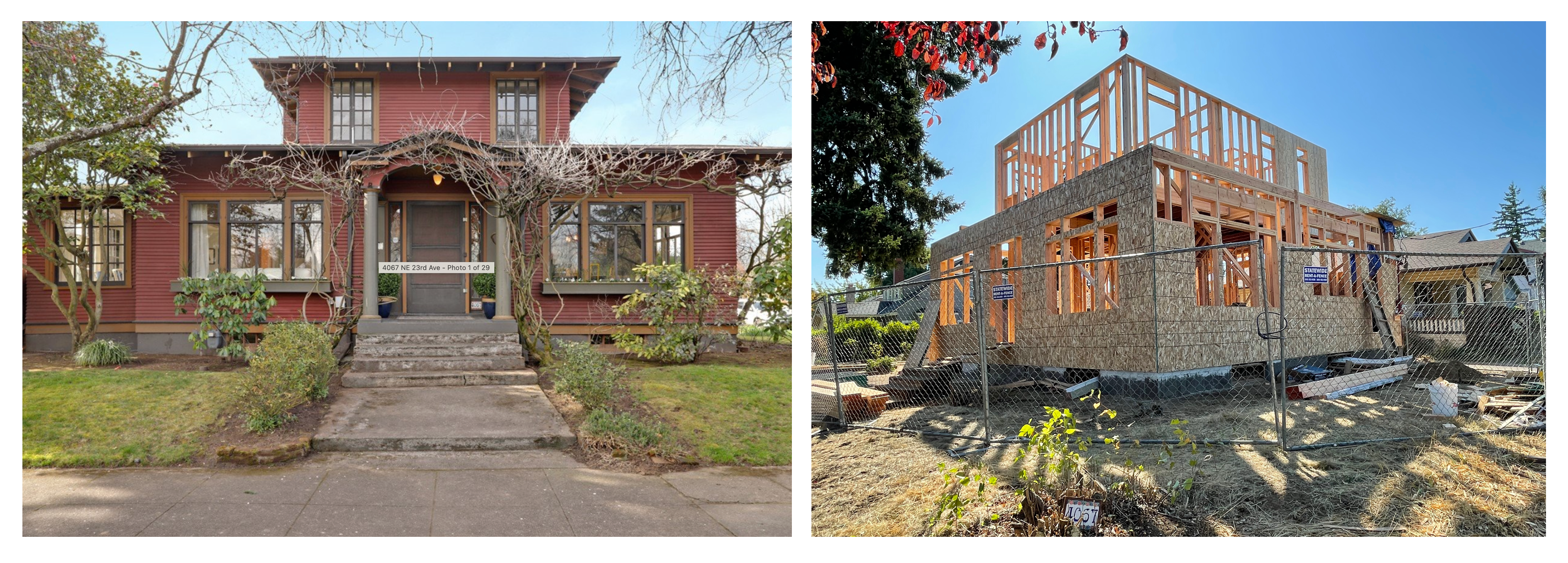
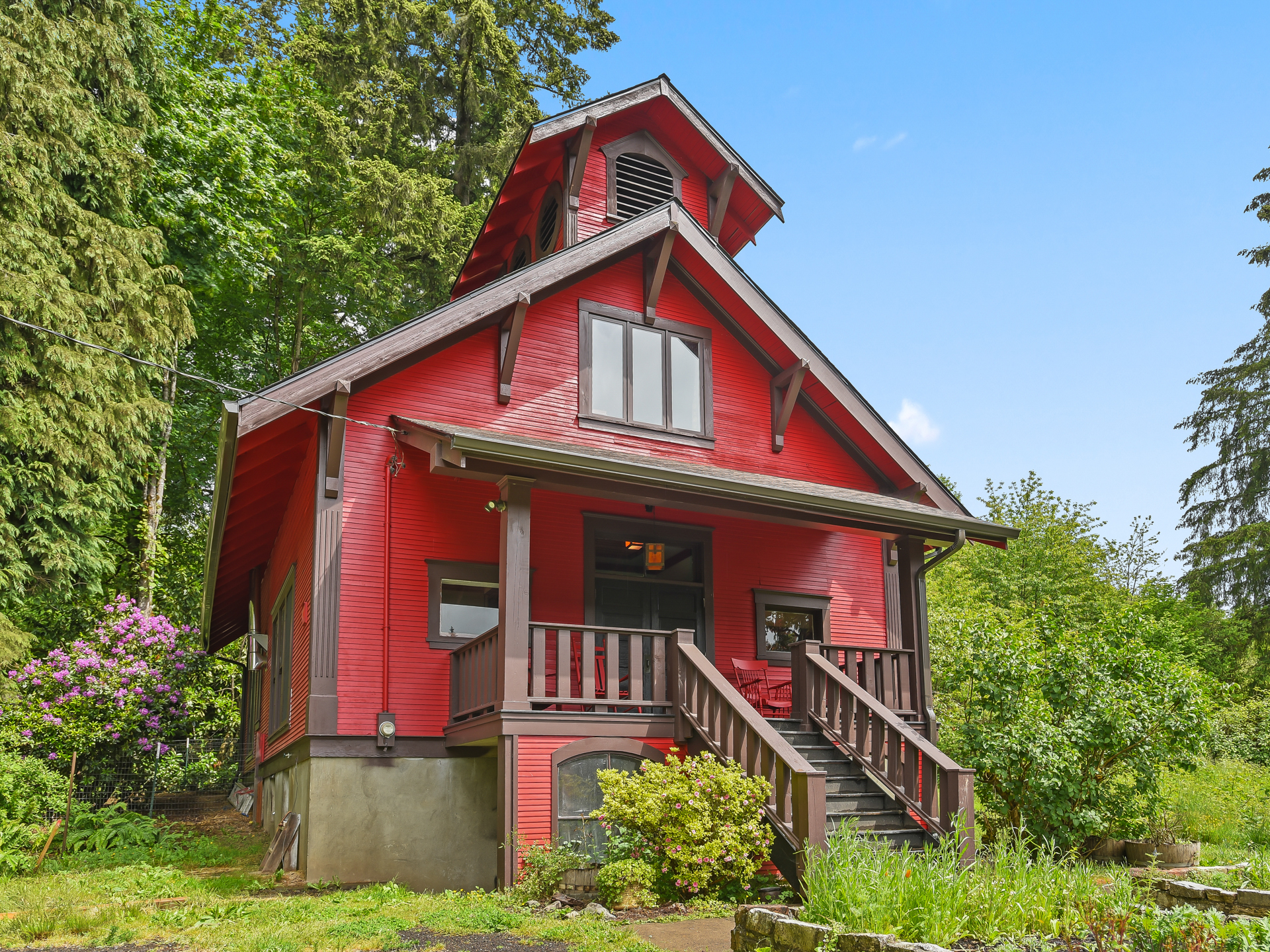
A few blocks west, on the southwest corner of Mason and NE 23rd (pictured below), we’ve watched the small red 1915 Arts and Crafts bungalow being taken apart piece by piece. Another somewhat unusual home, this one distinctive for its center hip-roofed cupola-like second story. The new home going up incorporates the foundation, and is also considered an addition, but the permit notes “whole house to be reconfigured.” The new framing does suggest echoes of the former building.
Here’s the before and during…
4067 NE 23rd before, and this week. It could be that the new construction will mirror aspects of the former.
For at least one of the bungalows on NE Mason Street, time will tell.
Note:
Summer seems to be “off season” for the blog: it’s hard to compete with sunshine and all things outdoors in Oregon. But the promise of rain and these cooler days brings us back inside. We have lots of topics for the blog this winter and fall, so even though it gets quiet around here between June and October, we won’t be a stranger in the rainy weeks and months ahead.
Plats are the puzzle pieces of our urban geography: invisible grids tied to a much larger grid known as the Willamette Meridian; part engineering plan, part map, part marketing pitch. Developers were required to submit them to the Multnomah County Surveyor’s Office before they divvied up the landscape. Today more than 900 individual plats make up the City of Portland. Knowing this provides a passport into the city’s development history.
But sometimes, the ones that don’t get developed are as interesting as those that do.
A recent research assignment took us up Cornelius Pass Road into the northwest reaches of Portland’s west hills, high above Sauvie Island in pursuit of the story of Folkenberg School, a 1913 Craftsman-style one-room building that operated for 23 years until the Great Depression and school consolidation forced its closure.
Folkenberg School in May 2024, courtesy Alan Baylis, RE/MAX Advantage Group, and REPIXS.
Leaning on our research, Portland Monthly just wrote a nice piece about the old school, which was converted to a residence in the early 1970s and recently placed on the market.
The simple school—built without indoor plumbing, heated by woodstove and lighted by tall windows that flanked the single large room—existed at the center of the Folkenberg Addition, a 51-block planned community that its developers dreamed would one day be an extension of Portland.
Portland experienced a land rush in the years after the 1905 Lewis and Clark Exposition, which attracted 1.5 million visitors, many of whom liked what they saw and wanted to stay. Much of Portland’s eastside was developed during this time, with new neighborhoods being platted every month, carved out of agricultural and forest lands. Real estate speculators made fortunes as lots were measured out, entire neighborhoods established and homes built.
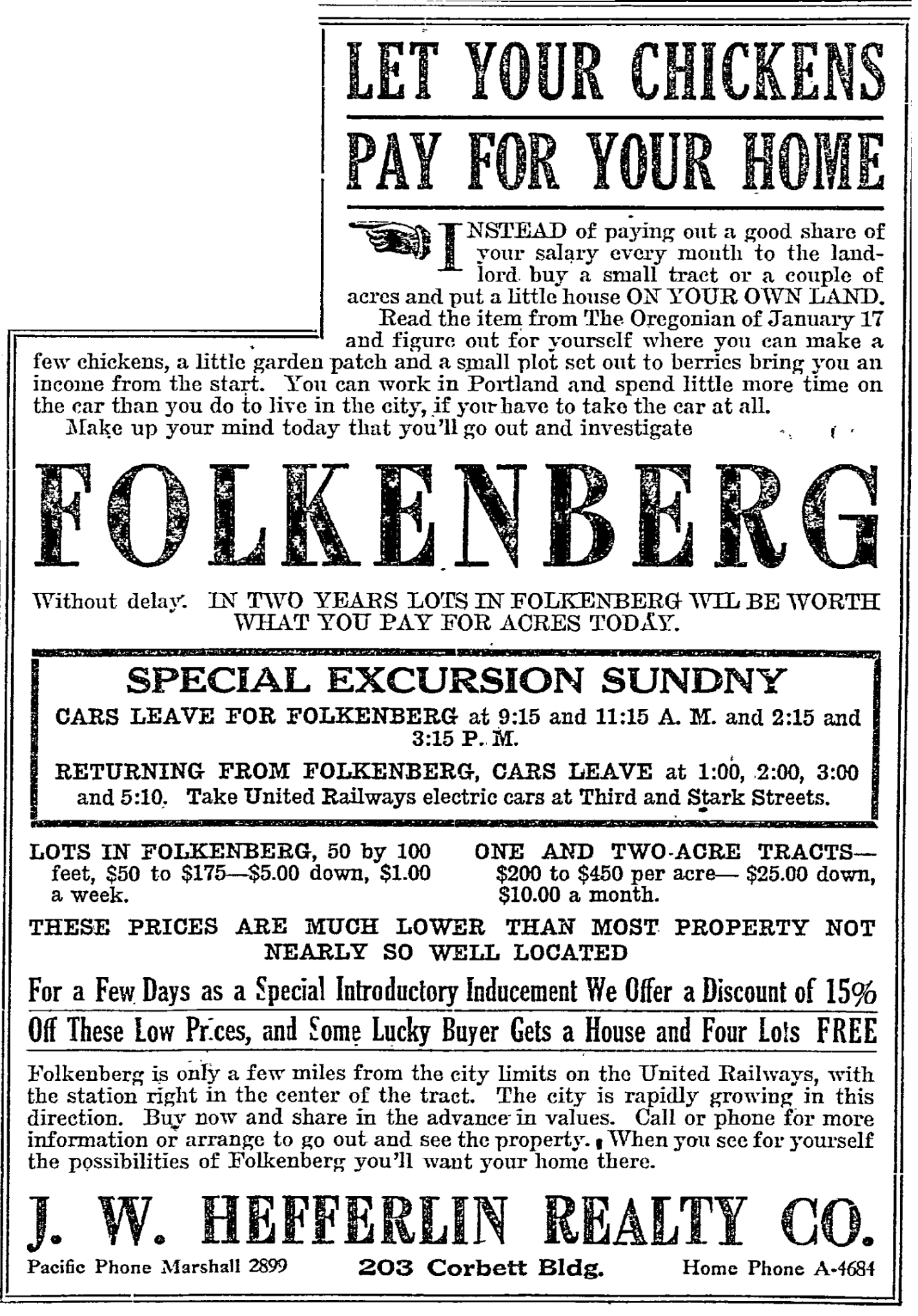
That same housing boom fueled interest in other undeveloped lands within striking distance of downtown. When he filed his plat for the Folkenberg Addition in January 1911, realtor and land speculator R.W. Hefferlin was probably thinking about the newly built Heights neighborhoods of Portland’s westside—Willamette Heights, King’s Heights, Arlington Heights, and Hillside. Still, he recognized the reality of the surrounding rural landscape and in fact promoted the revenue generating aspects of chickens, fruit trees and nearby fields.
Folkenberg Plat, 1911. Click to enlarge.Red box indicates location of Folkenberg School. Cornelius Pass Road is at far left. The wide arc sweeping through north-south is the United Railways line.Nearby were other plats with similar ambitious planned developments.
In February 1911, United Railways completed a 4,103-foot railroad tunnel through the hillside, making a graceful arc right through the heart of Folkenberg and connecting the Tualatin Valley with Portland. Hefferlin made sure there was a rail passenger platform built in Folkenberg, and even named one of the improbable roads Depot Street to make sure everyone knew about the rail link. Remember, in the time before widespread use of automobiles, connecting subdivisions to Portland by rail was the number one factor ensuring property sales.
The namesake Folkenbergs were a Norwegian immigrant family who worked 300 acres in this area and ran a small sawmill. Patriarch Louis Folkenberg died unexpectedly in 1892 at age 54 leaving wife Inger Maria and 10 children, ranging in age from three to 24. By 1911, with children fledging and needs changing, the family sold off 107 acres for $14,455 to developer Hefferlin, who divided it up and began selling lots.
From The Oregonian, January 25, 1911. The home Hefferlin advertised as giving away free was the 1880s farmhouse built by Louis and Inger Maria Folkenberg.
When he platted Folkenberg, Hefferlin was already in the process of platting and marketing other nearby subdivisions known as Bayne Suburban Farms and Thompson Gardens, which were joined by other adjacent planned subdivisions called Sheltered Nook, Ingleview, Greenoe Heights, Cornelius Park, and Plain View Acres.
In 1913, the arrival of a few new families, and hopes for many more—plus the presence of many young Folkenbergs—eventually led to the call for a school to serve the area. Previously, children from this area traveled down the hill by foot or horse and wagon to Holbrook, Burlington or Linnton for schooling.
At its peak in 1916, the school had 33 students. But by the early 1920s, it was becoming clear J.W. Hefferlin’s suburban vision for Folkenberg was not going to pan out. Property sales slowed and then stopped. United Rail Lines focused on freight, not passengers. The area, as it turned out, was not within easy striking distance of downtown and in fact the people who wanted to live here were not particularly interested in things related to city life.
In the late 19-teens, Hefferlin stopped paying property taxes on the remaining lots he was trying to sell. Then in the summer of 1923, he gave up all together and moved to Los Angeles.
Through the late 1920s and into the Great Depression of the early 1930s, school enrollment slumped. In 1936, with enrollment down to just six students, parents in the area voted to close the school, sending the remaining kids to Holbrook School down the hill on Highway 30.
Folkenberg and its neighbor plats, conceived at a time of optimistic growth, remained the mostly rural lands they are today. The plats became ghosts, just lines on a map. The tax lots are still there, rolled together now into larger holdings. But Hefferlin’s idea of the next-big-thing westside neighborhood fled with him to Los Angeles, leaving behind a deserted old school tucked into a hilly rural landscape that faced years of hard use and deferred maintenance until new owners came along in the early 2000s to bring it back to life.
We’ve come across another clue that helps us visualize the area on the east bank of the Willamette River opposite the northern end of Ross Island, home to the most popular swimming hole in early Portland. This spring we’ve been writing and thinking about Bundy’s Baths, which we discovered following a thread of interest spun by an album we received of 100-year-old photos of canoeing the Willamette in downtown Portland.
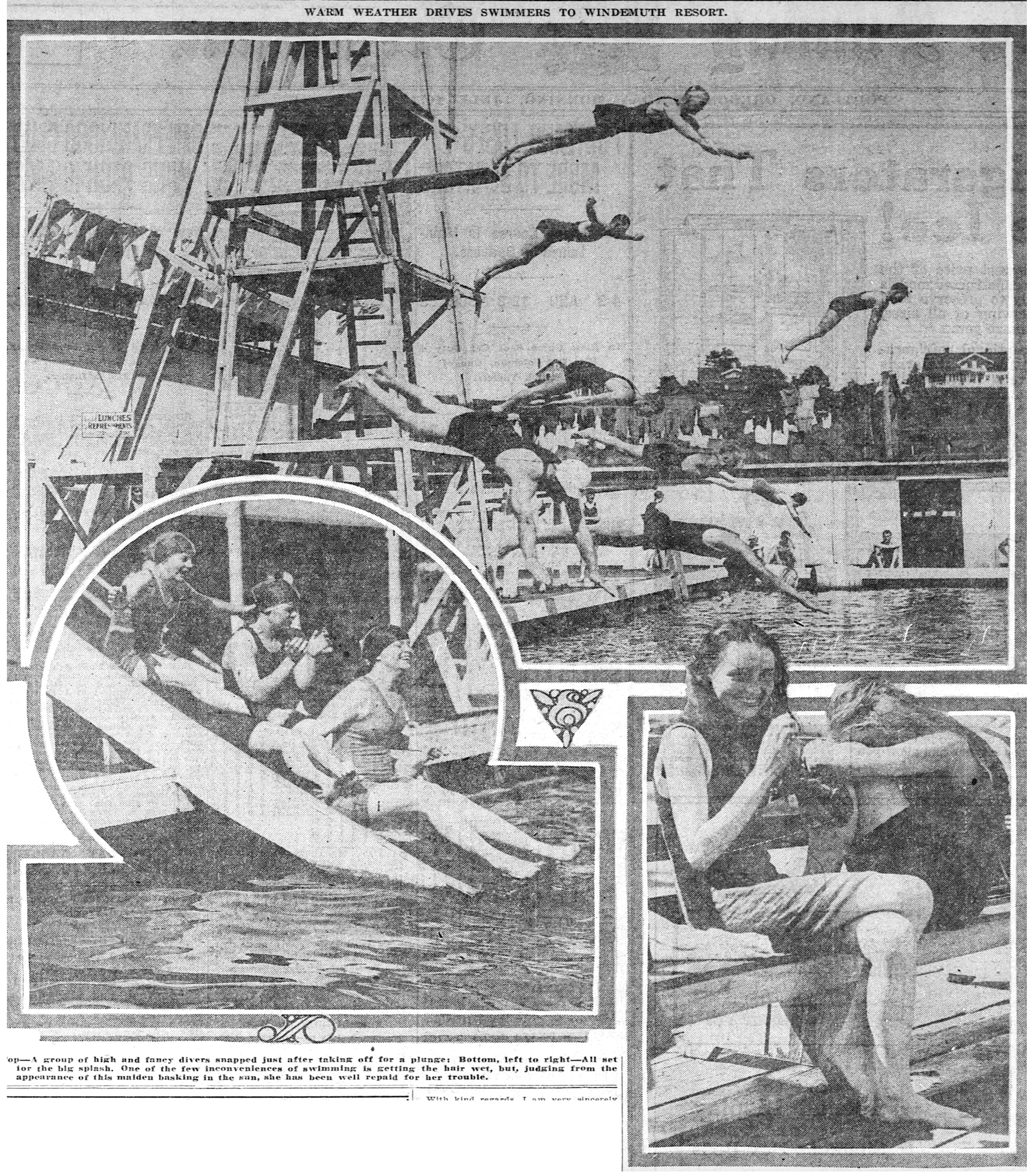
From the 1890s until the mid 19-teens, Bundy’s was an important eastside portal to the river, regularly hosting more than 1,000 swimmers on a hot summer day. Changing facilities, a snack bar, diving platforms, docks to hang out with friends and an enclosed swimming area made up the “bath house” and were afloat along the bank, anchored to piers that held them in place.
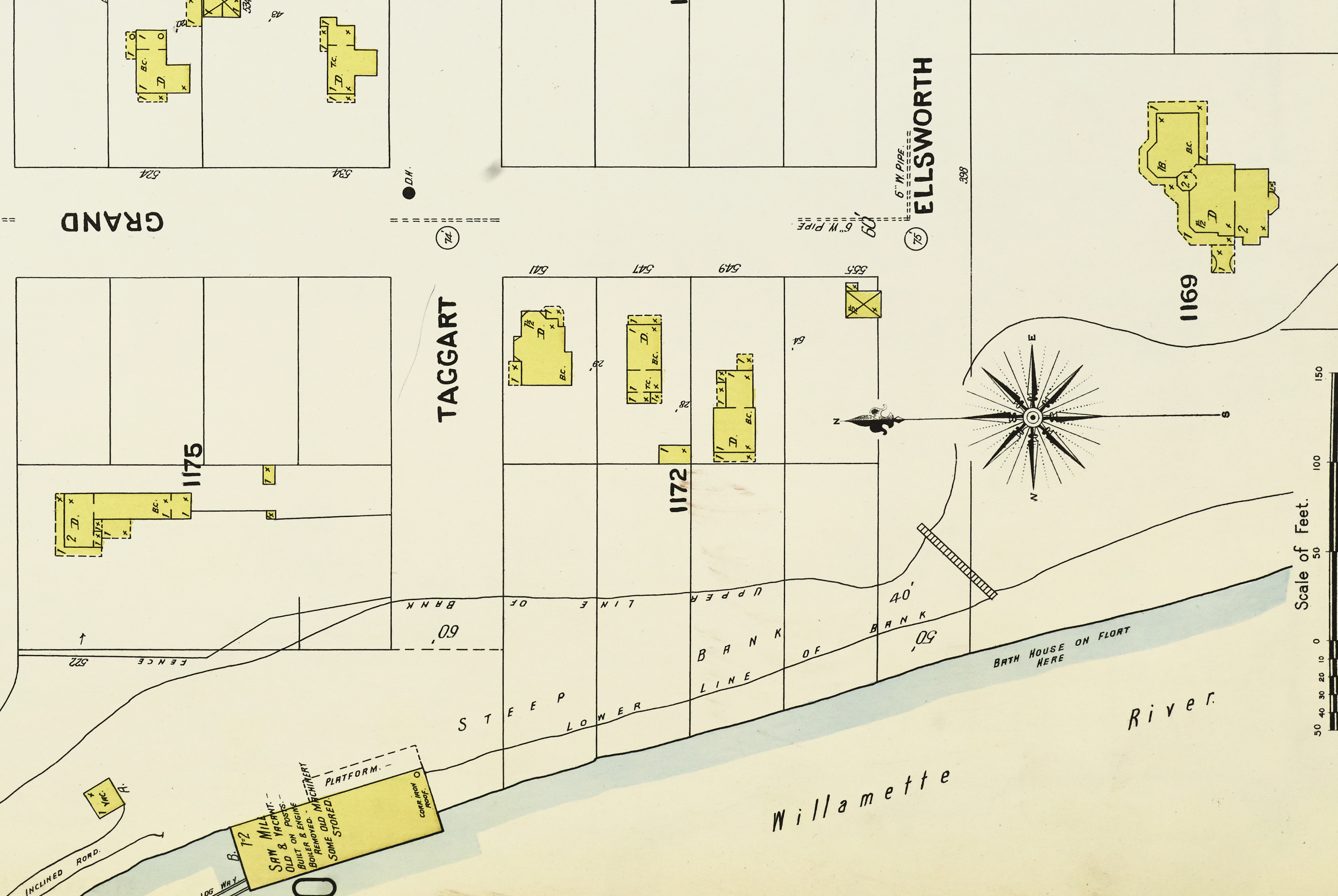
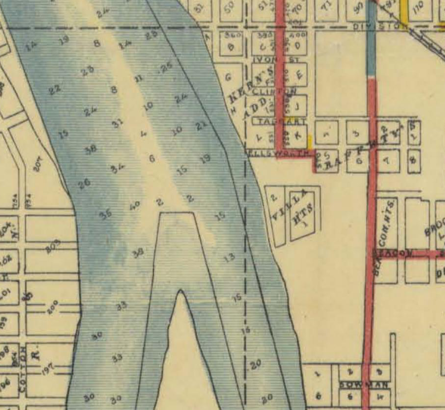
Here’s a detail from the Sanborn Fire Insurance Company map of this area from 1901. In these early days, Sanborn mapped 12,000 U.S. communities to help fire insurance underwriters evaluate risk by showing the location and type of structures, water mains and hydrants that were present. Today, we love them because they are a snapshot in time and allow us to visualize places in that era. Have a good look at this one and then we’ll discuss.
Detail from Plate 127, Sanborn Map Company, 1901. Click to enlarge. This and other Sanborn maps of the vicinity can be accessed here through the Library of Congress.
Remember that construction of the Ross Island Bridge in 1925-1926 completely remade this landscape: the bridge essentially follows the path of Ellsworth Street, which was renamed Woodward in 1910.
Interesting to note the contour lines and the steepness between the upper line of bank and the lower line of bank, a slope angle that remains today in that area. Back then, people used a stairway to get up and down from the river.
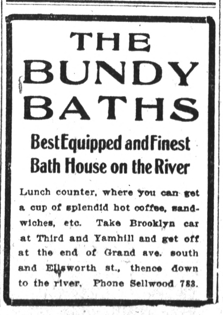
Advertisements to Bundy’s—and later to the mid-river swimming platform and dance floor known as Windemuth—directed visitors to take the Brooklyn streetcar to the foot of Ellsworth Street where they could proceed to the water…presumably down those stairs.
Note that the structures were afloat. This makes sense. Periodic news stories about spring high water reported on Bundy’s buildings and other floating residences periodically being washed away downstream. It was a temporary community, of necessity.
The structures to the north were old then, holding disused machinery from the Inman-Poulsen Mill. The main portion of the mill was located downstream farther north along the bank, where the river was deeper and ocean-going freighters could tie up to take on lumber from the mill. Note how Sanborn observed the roof of one old building was corrugated iron roofing…always thinking fire risk.
The large house in the upper right is still standing today: the Poulsen House, built for Johan Poulsen, partner with Robert D. Inman, who had a very similar house nearby at SE 6th and Woodward that was demolished in 1958 to make room for a parking lot. The presence of the Poulsen house in relation to where the swimming took place helps us locate ourselves today.
If we could zoom out a bit on this Sanborn plate and look to the north, you would see all of the other east-west streets in the area—Grant, Sherman, Caruthers—essentially ended at the top of the bank (or ran into the Inman-Poulsen sawmill) where it dropped off to the river. We’d also see Stephens Slough (fed by Brooklyn Creek) which filled almost as far east as SE 10th Avenue that would flood whenever the river rose, where nothing was built, even though there were lot lines and streets.
There are more clues yet to find about this place, and maybe photos. We’ll keep looking.
This week, we’ve been thinking about Bundy’s: a placename attached long ago to a portion of the eastern bank of the Willamette River opposite Ross Island. We mentioned the name in our recent post about Windemuth, the floating dance floor and swimming platform anchored off the north end of Ross Island that was popular between 1914-1924.
From the Oregon Journal, July 29, 1911
Reporting in the local papers from the early 1900s referred to a swimming venue in this area called Bundy’s Baths and the name quickly became applied in a shorthand way to signify the general vicinity we think of today on the east side of the river just north of today’s Ross Island Bridge. Over the years, we’ve bumped into passing references to Bundy’s: for instance, George Asa Eastman, the lead architect for Oregon Home Builders, had a houseboat / secondary residence in this area in the early 1900s.
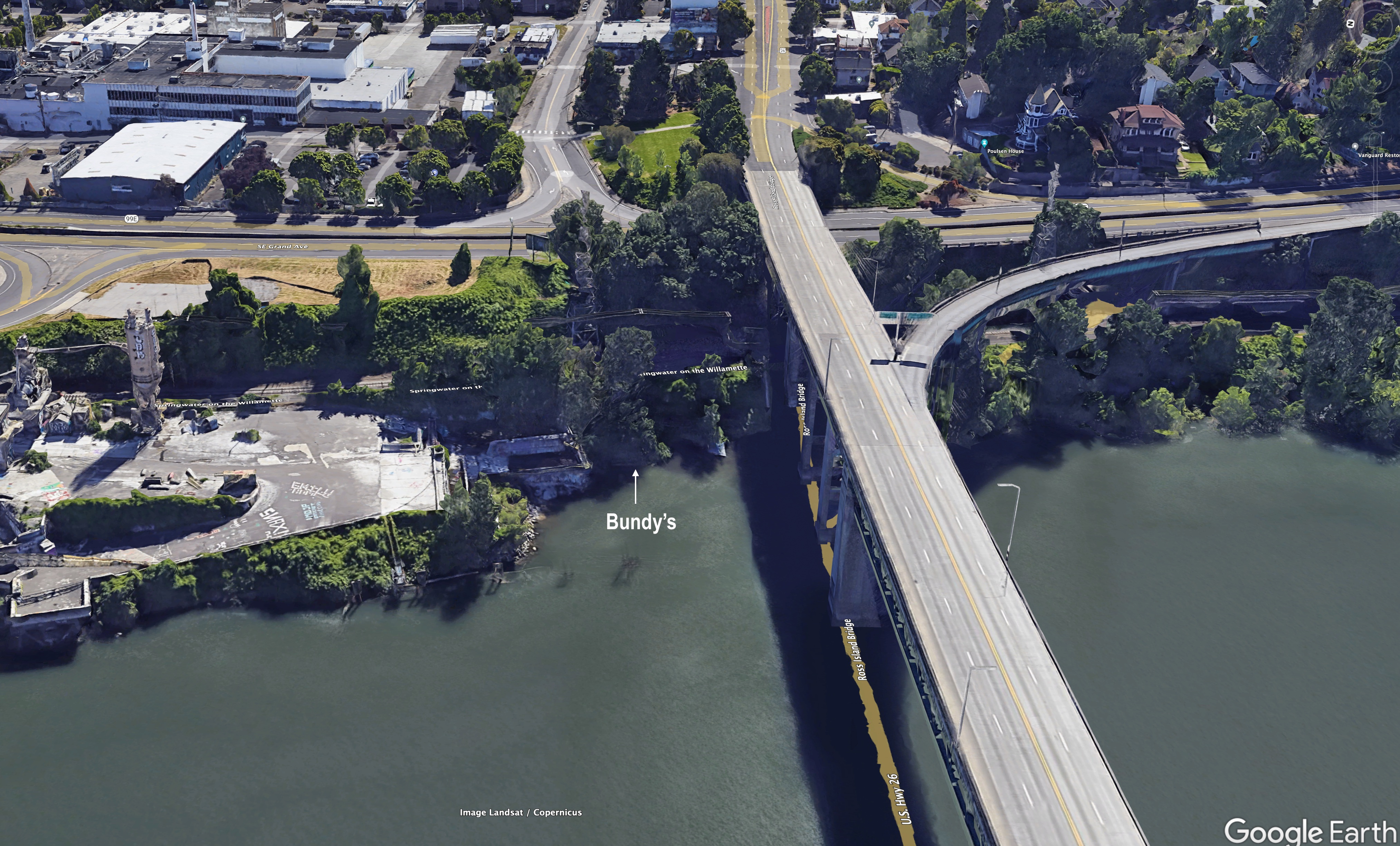
The vicinity of Bundy’s today, Google Earth photo. Click to enlarge.
So, while we’ve generally thought of this area as Bundy’s, we’ve never really known where the name came from.
Furthermore, because so much has changed there in the last 100 years (including construction of the bridge), we’ve figured Bundy’s was extinct both as a place and as a name. We were pleasantly surprised this week, following the Windemuth post, to hear from a reader with a question about “Bundys Landing,” referring to the area’s later industrial years as a log and lumber loading zone for the nearby Inman-Poulsen mill, and after that a processing site for Ross Island Sand and Gravel. Maybe others have heard someone talk about Bundy’s, though it has certainly disappeared from any living memory.
This made us curious for more: Who was Bundy? What was this place? Where was it exactly? What else was going on here? What does it look like today? We love questions like this.
From The Oregonian, January 20, 1908
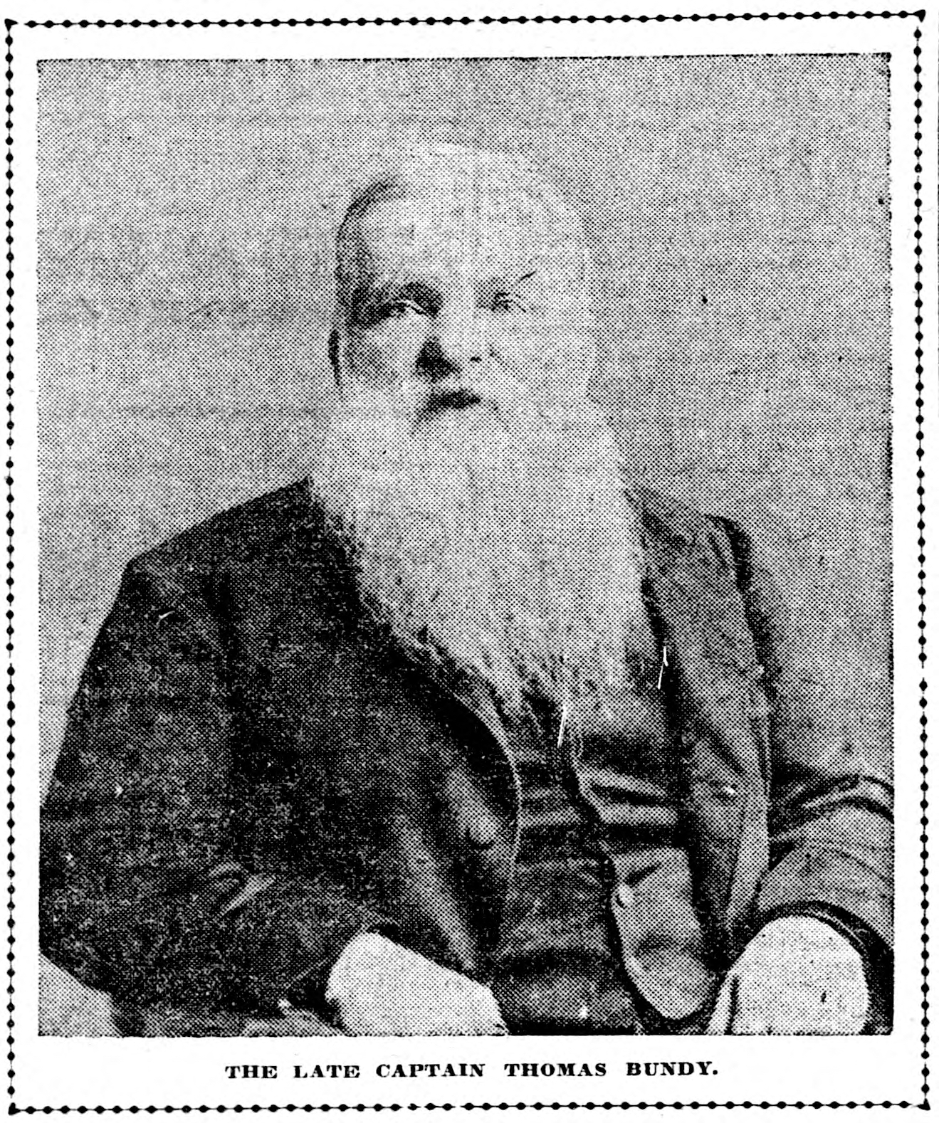
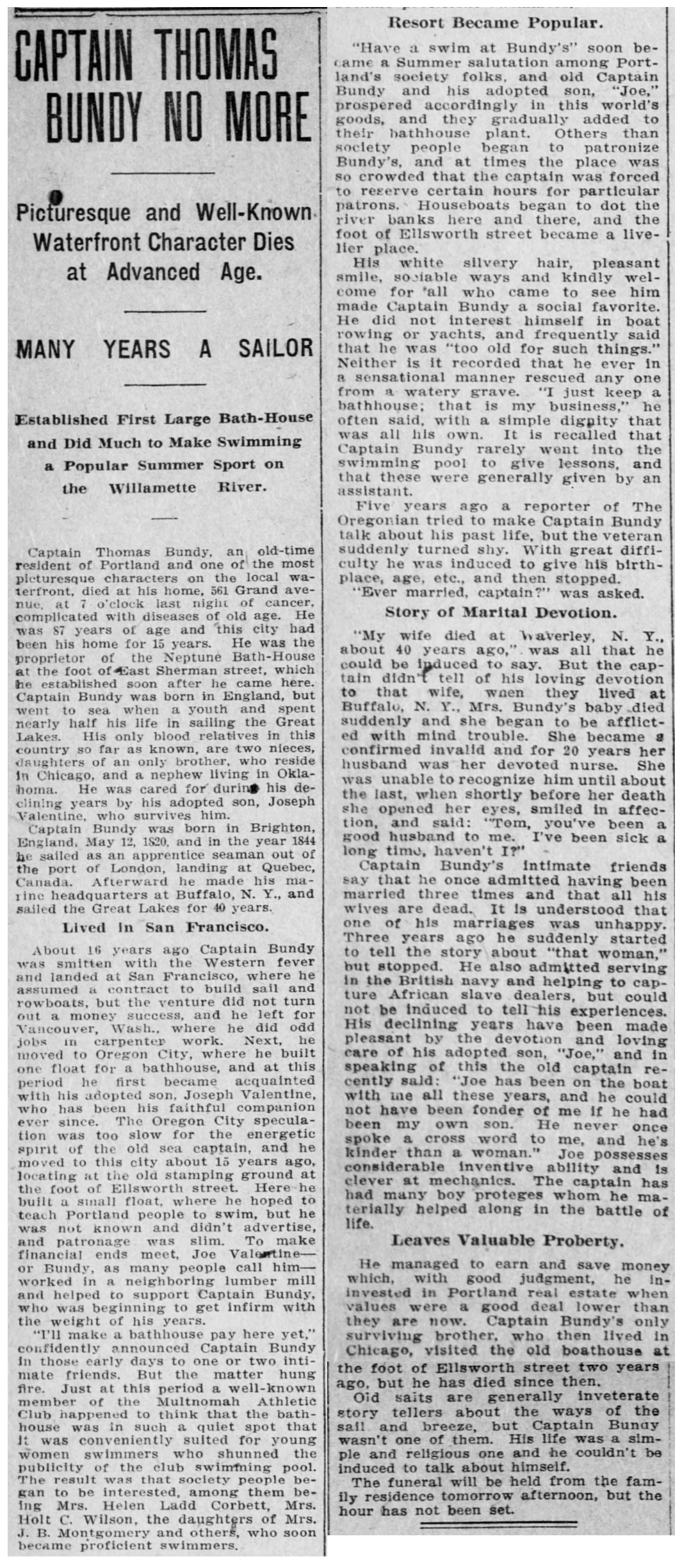
When he opened the eponymous bathhouse here in the spring of 1898, Thomas Bundy was in his late 70s, a British-born sailor, boat builder, real estate speculator and lover of everything related to swimming. He was known as “Captain Bundy,” though his days in a ship on water were mostly on the Great Lakes and well behind him. Reporting suggests Bundy was a quiet person, reluctant to talk about both his past (which included three marriages and various businesses), and his present, which included living on a nearby houseboat with Joe Valentine, who was like an adopted son. Bundy was a transplant to the Pacific Northwest, arriving in the early 1890s from San Francisco and living in Vancouver, Washington and then Oregon City before arriving in Portland.
His obituary from January 20, 1908 describes Bundy’s interesting life, and credits him as being a leading advocate for swimming in the Willamette River:
From The Oregonian, January 20, 1908
When it opened in late May 1898, Bundy’s vision for a swimming resort away from the downtown area drew immediate interest.
From The Oregonian, May 29, 1898
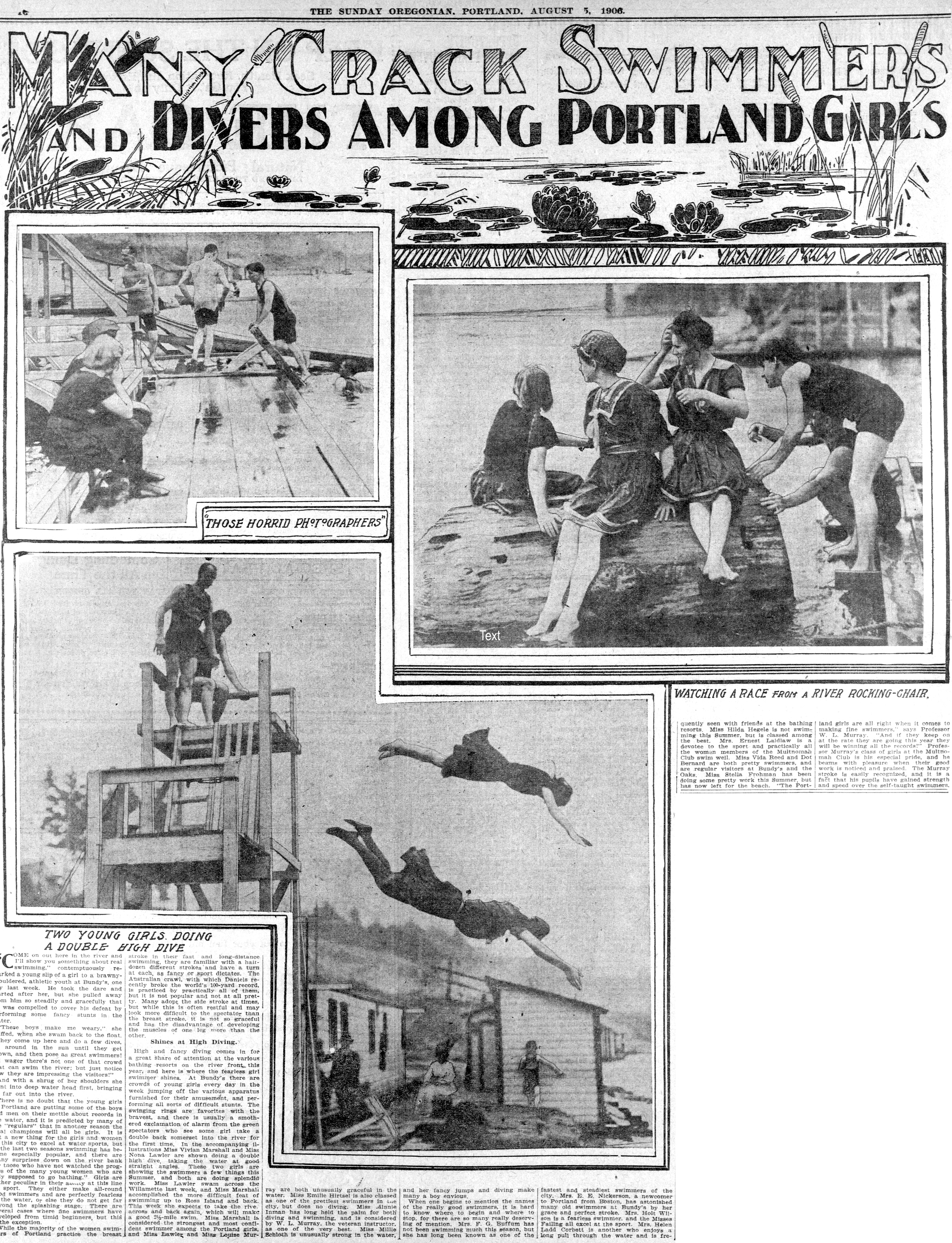
Members of the Multnomah Athletic Club began frequenting Bundy’s resort—which was also known as the Neptune Baths—and soon it became the place to go, particularly for girls and women. Swimming and diving competitions took place here and eventually the Portland Yacht Club relocated just downstream to be nearby. It was the center of gravity for river swimming in Portland. We know it was busy: The Oregonian reported Bundy’s rented out 1,300 swimming suits per day in August 1915 and that more than 40,000 people used the foot of Ellsworth Street each year in the 19-teens for landing and embarking on the river. News coverage was abundant.
Click to enlarge: From The Oregonian, August 5, 1906. Note the buildings and shoreline at Bundy’s in the diving photo above. Below, from The Oregonian on August 9, 1903(note the sketch of Captain Bundy presiding).
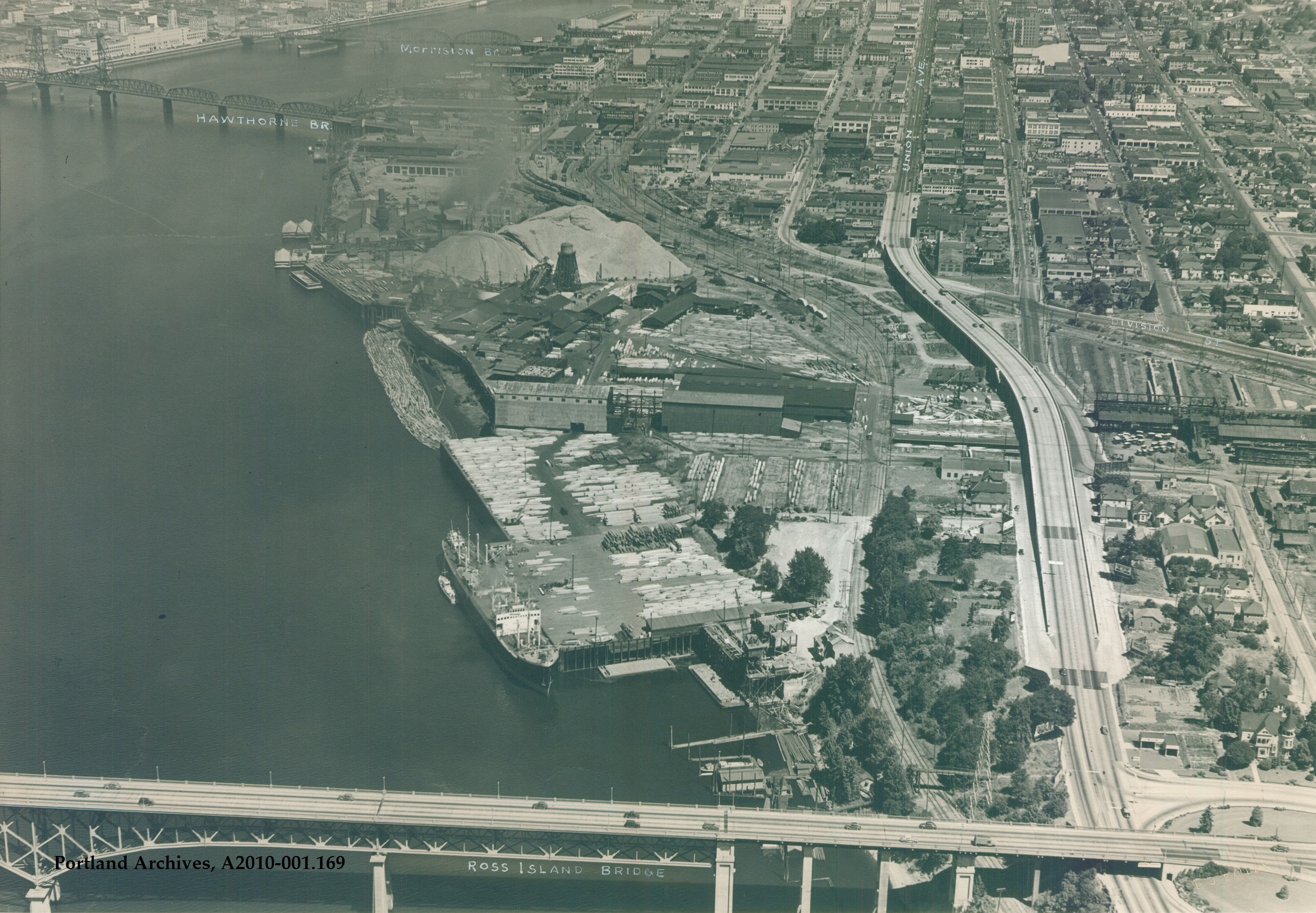
Bundy’s Bath’s appears to have been a collection of simple buildings for dressing, an enclosed area for swimming, a snack bar, and a set of diving platforms on the east bank of the river at what was the foot of Ellsworth Street. Here’s a map that puts this in context, and remember this is before the Ross Island Bridge, which came along in 1926. In 1910, Ellsworth Street was renamed Woodward Street.
Detail from the 1894 paving map of Portland. Bundy’s was located where Ellsworth Street met the river. The pink roadway indicates gravel.
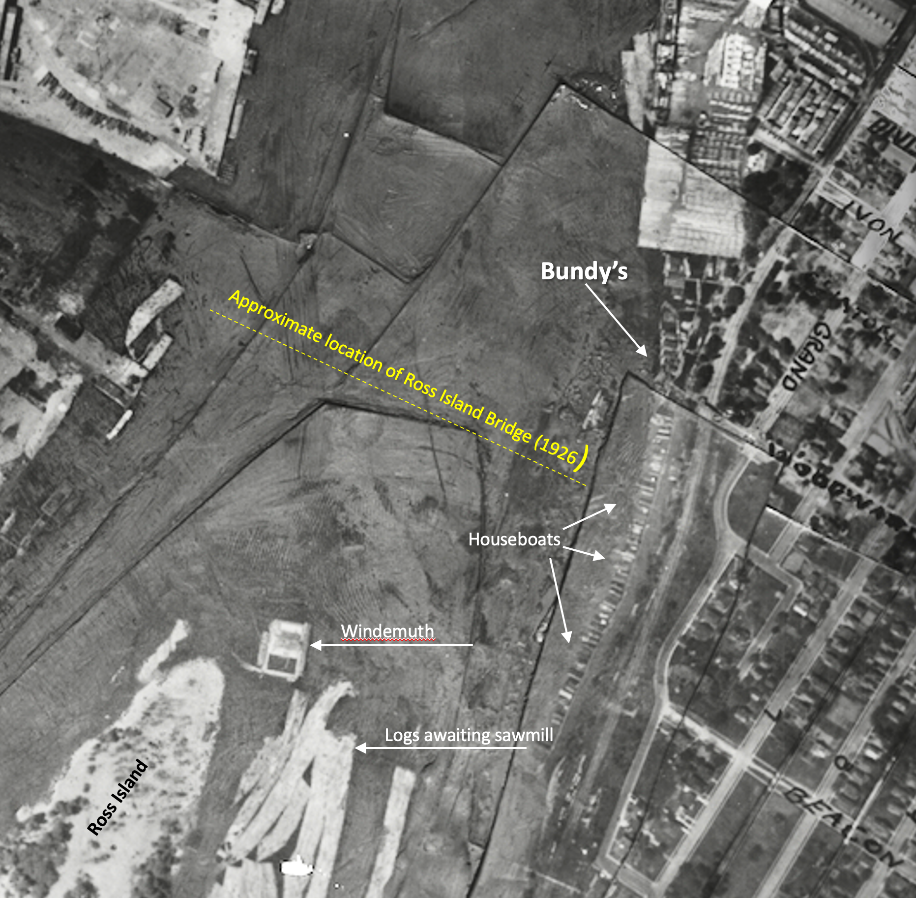
The vicinity of Bundy’s at the foot of Ellsworth Street was a kind of jumping off place into this watery world: if you were out on the river in this area to have fun (or to live in one of the houseboats) you passed through here. A careful look at aerial photos from the 1920s and 1930s shows a solid line of houseboats from Bundy’s south along the east bank of the river well into the bend across from Ross Island, and even lining the eastern shore of Ross Island.
1925 aerial photo. Click to enlarge.
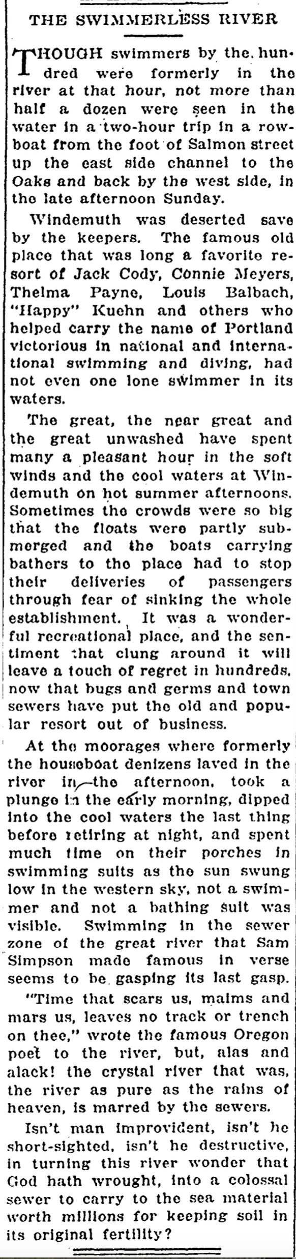
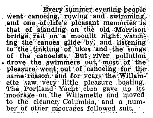
From 1900 until the early 1920s, Bundy’s was the epicenter of swimming in this stretch of the Willamette. But by 1925, Portlanders abandoned the river because it had become the main receptacle for the city’s raw sewage, and due to heavy industrialization on this side of the river.
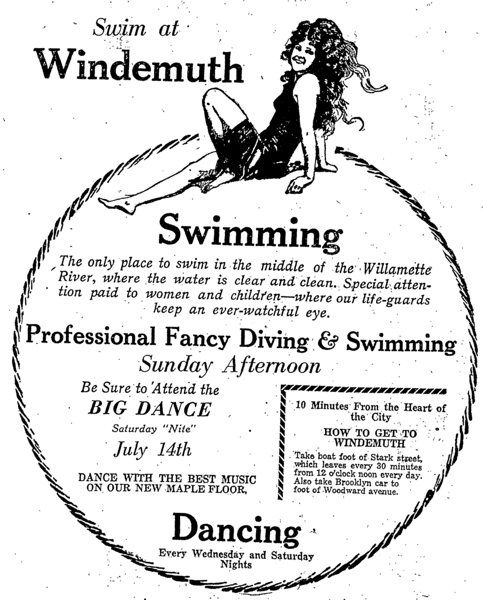
In fact, some credited the growing problem of raw sewage outfall as the motivation behind the swimming platform that became Windemuth, which opened in 1914 with the slogan “The only place to swim in the middle of the Willamette River, where the water is clear and clean.” The river banks were becoming clogged and foul-smelling with an awful mix of sewage and debris which could only be avoided by getting out in the current, in the middle of the river.
By 1919 the Bundy buildings on the eastern shore were sold and dismantled. In later years—long after those swimmers who loved this place had left—heavy piers and docks were constructed at the site where Bundy’s once stood to load lumber onto ships from the nearby Inman-Poulsen mill. Here’s a view from 1940:
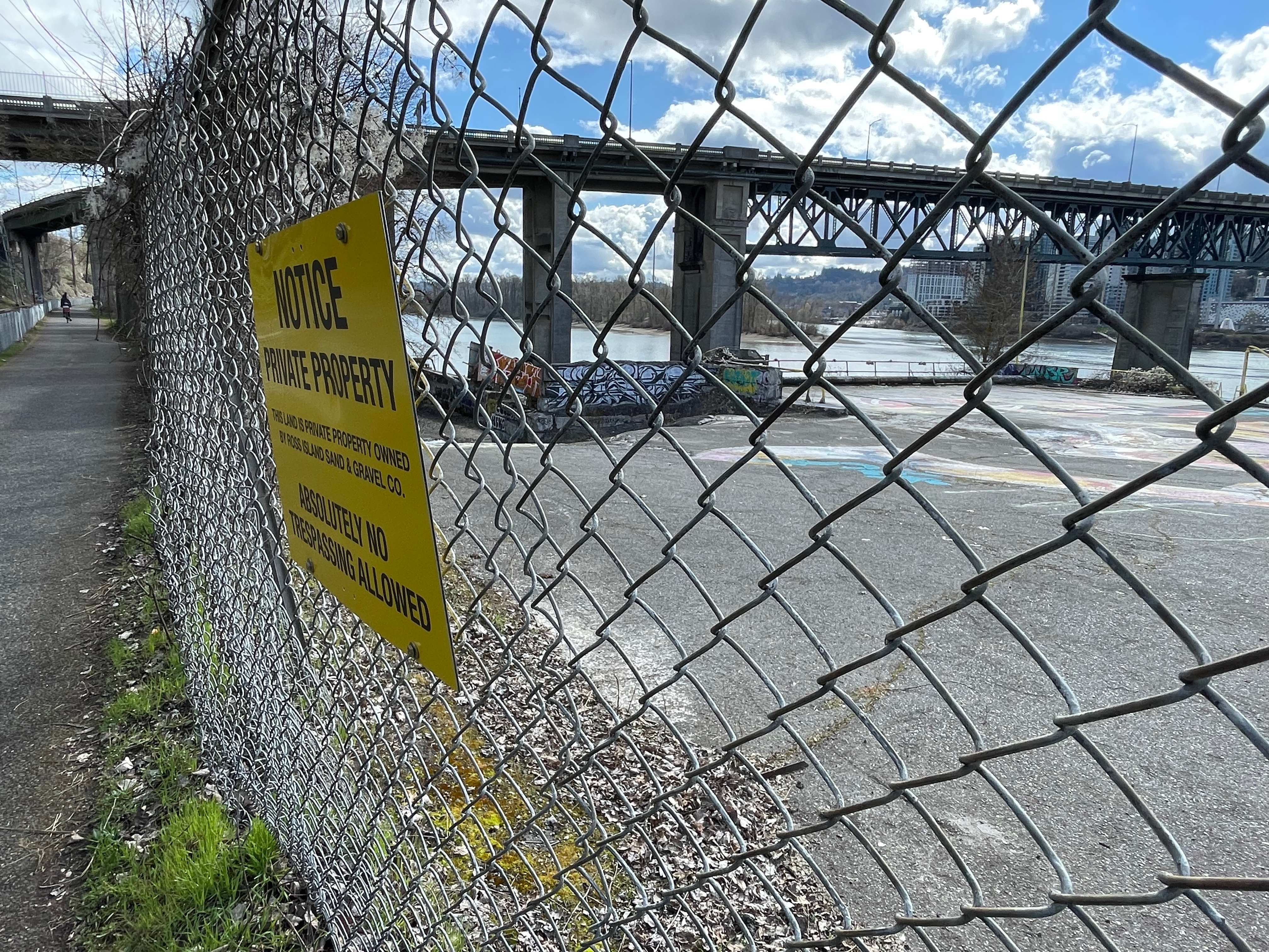
Today, the area is a desolate, post-industrial mass of graffitied concrete behind a tall, barbed wire security fence.
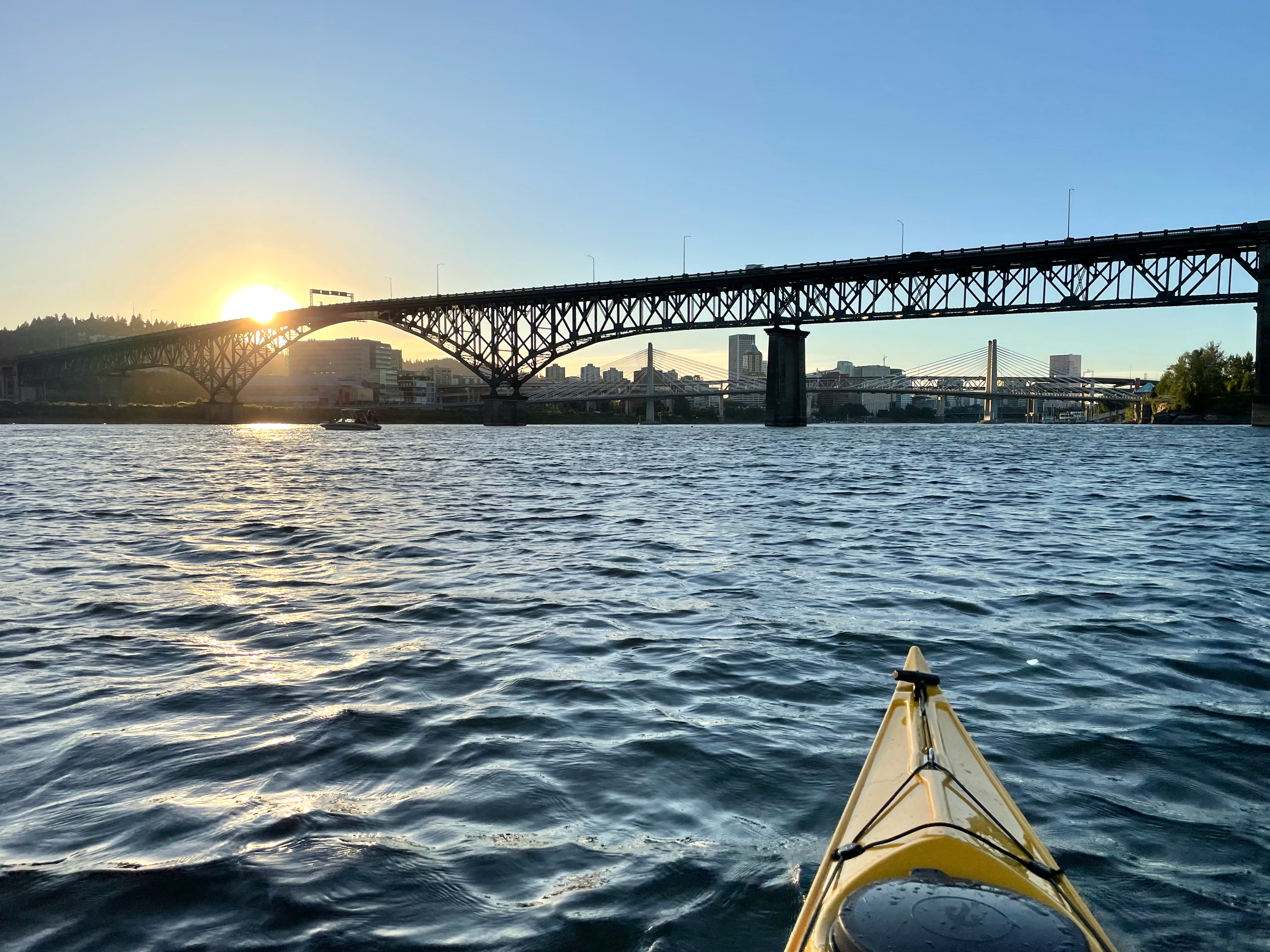
We’ve paddled and pedaled through this area hundreds of times and never knew these echoes from the past. Maybe you have too. Now we know. It’s time to get back out there in the kayak and remember what was a special place.
Last fall we shared amazing 100-year-old photos of the Willamette River. What a treat to be able to see and learn about river recreation in the early 1920s, including the rise of Windemuth, a popular swimming, diving and dancing resort that was afloat but anchored just downstream from the north tip of Ross Island.
From The Oregonian, July 10, 1921
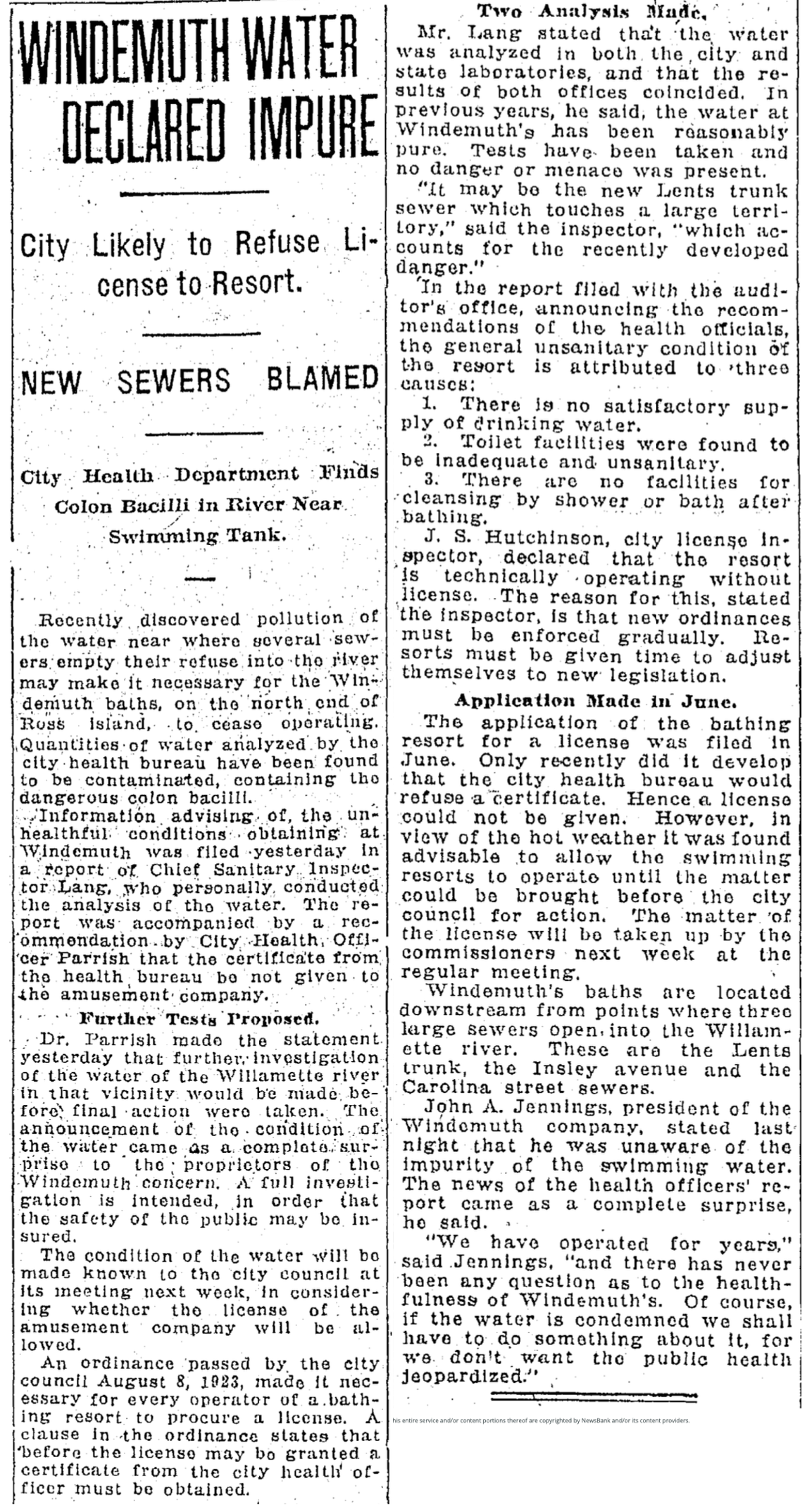
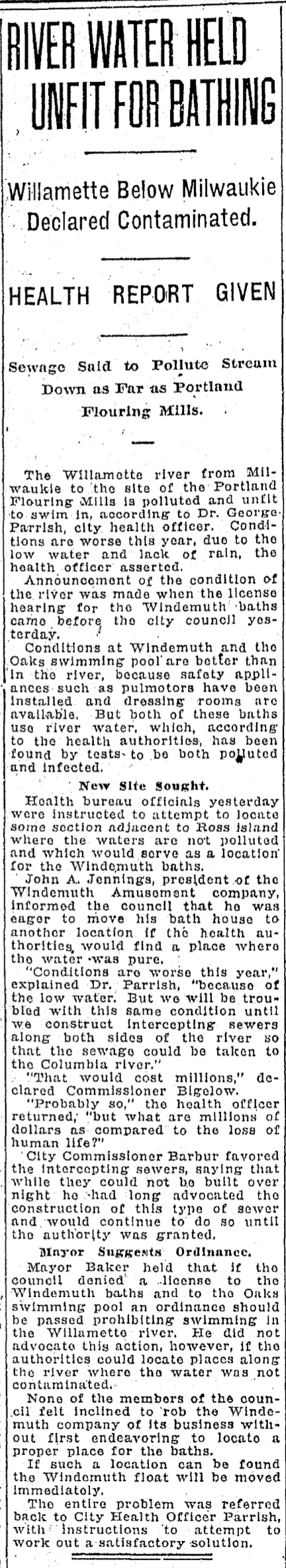
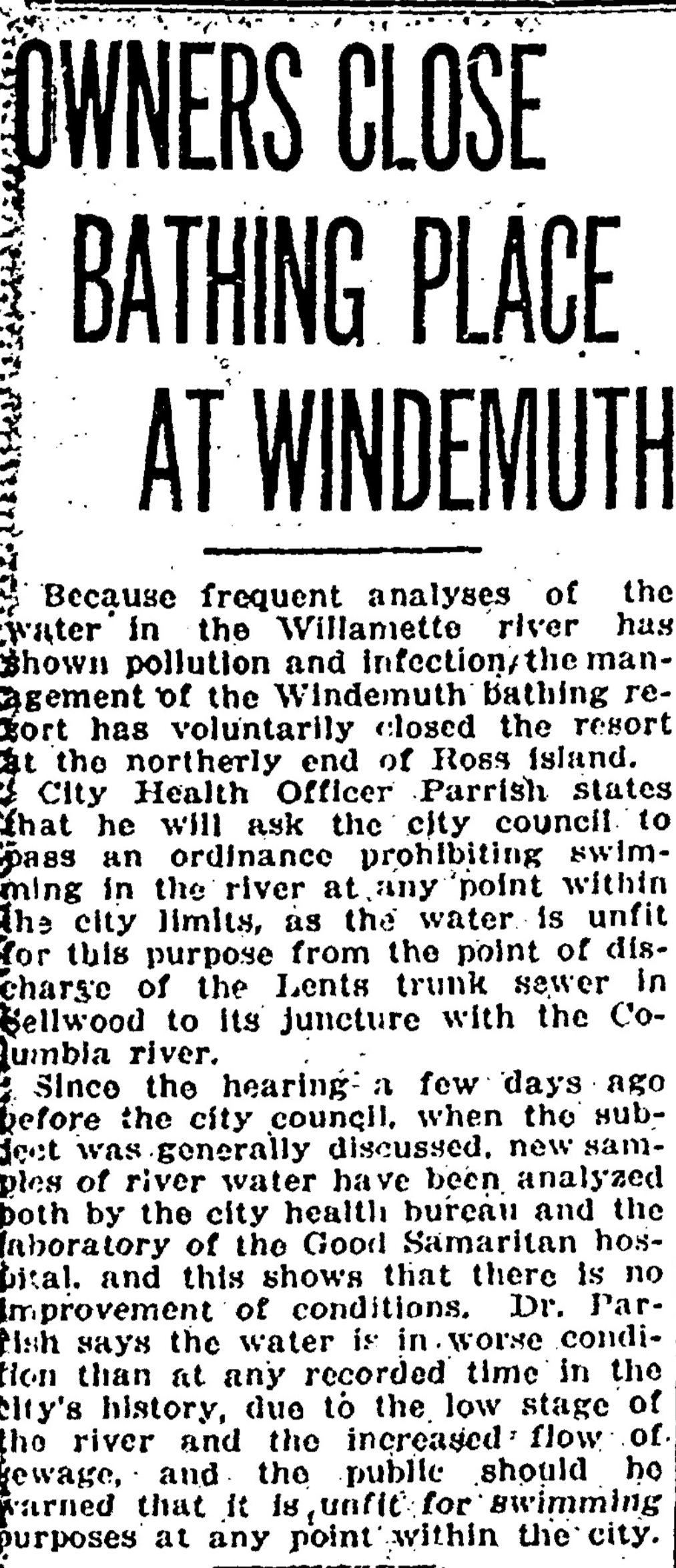
We left this story on July 31, 1924, with the owner of Windemuth deciding to close the resort due to water quality concerns. Anyone reading the news stories in the hot-dry, low-water summer of 1924 could see the handwriting on the wall. Not a big surprise: much of Portland’s raw sewage was piped straight into the river. In mid-July, water tests had noted the presence of Bacillus coli in the water and City Council hinted at a swimming closure.
From The Oregonian, July 16, 1924
Ten days later, during City Council’s hearing on the operating license for Windemuth, the focus was on the looming swimming ban and the presence of sewers. Windemuth operator John A. Jennings signaled he was ready to move the floating resort anywhere the water was clear, but with Portland’s sewage system relying almost entirely on the Willamette River, there was no central alternative. Maybe build intercepting sewers that would shunt sewage to the Columbia River, wondered City Health Officer George Parrish, who had suddenly been called on to deliver a solution to swimming in the Willamette (see the last paragraph below).
From The Oregonian, July 25, 1924
The primary culprit was the Lents Trunk Sewer, a 5.2 mile tunnel, 56 inches by 71 inches in size, that emptied into the river at Harney Street, a stone’s throw from the diving boards at Windemuth. When it opened in August 1923, the line received sewage from about 30,000 homes as far east as Foster Road. In addition to the Lents Trunk Sewer, two additional lines—the Insley Avenue Sewer and the Carolina Street Sewer—also discharged into the river directly across from Ross Island and upstream from Windemuth. We’ll remember the boom in home construction and population in the early 1920s. It all had to go somewhere.
In early August after Windemuth was closed and swimming banned from the river, an editorial writer from the Oregon Journal spent Sunday afternoon rowing from downtown out and around Ross Island. The heartbreaking column on August 5, 1924 was an elegy for the river:
From the Oregon Journal, August 5, 1924
We actually catch a glimpse of the floating Windemuth in the center toward the bottom of this 1925 aerial photo, one year after its closure. There’s lots to look at here, so we’ve pointed out a few things including the houseboats that once lined the river in this location—a Bohemian community of artists, architects, writers and others; floating log rafts awaiting the saw at nearby mills; the location of the future Ross Island Bridge which would come along in 1926, and the floating rectangle that was Windemuth.
Detail of 1925 aerial photo with labels added. Click to enlarge.
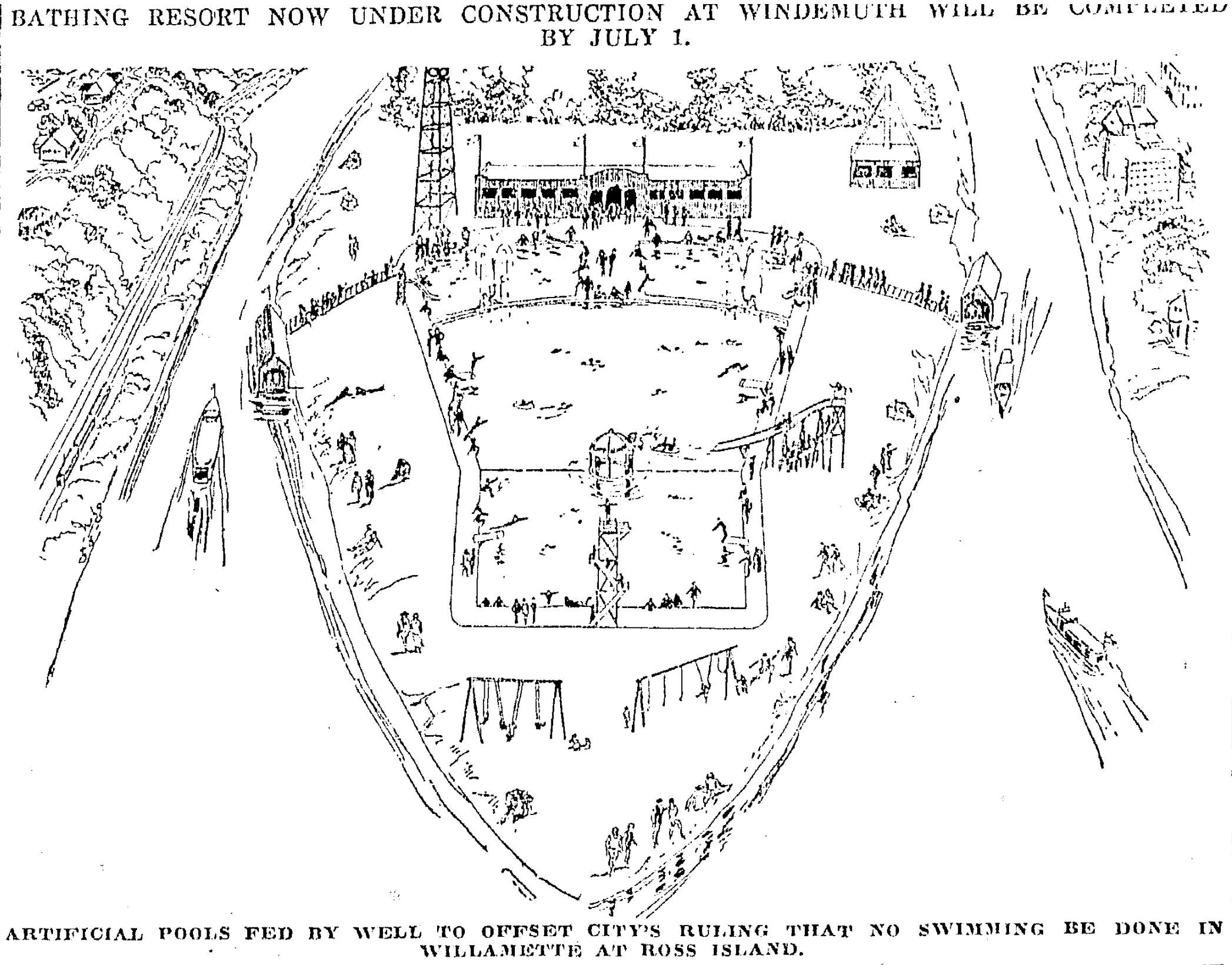
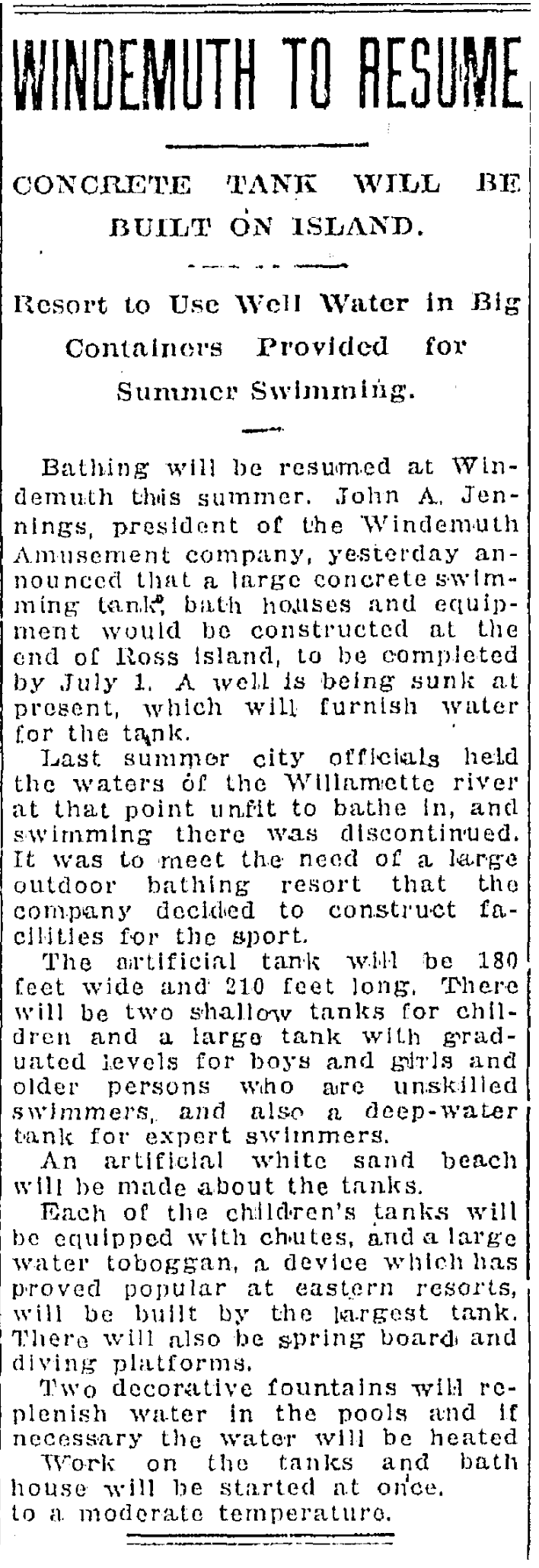
Meanwhile, John A. Jennings was busily trying to find a way to salvage some aspect of the Willamette River swimming tradition and the market niche he had created with Windemuth, announcing bold plans to build a giant swimming tank on the north end of the island.
From The Oregonian, May 24, 1925
But Jennings’ vision was never fully realized: he died of a heart attack in April 1927. Some small related buildings existed on the island then, and the new bridge loomed overhead just downstream. The fate of the actual structure of floating Windemuth was never reported on.
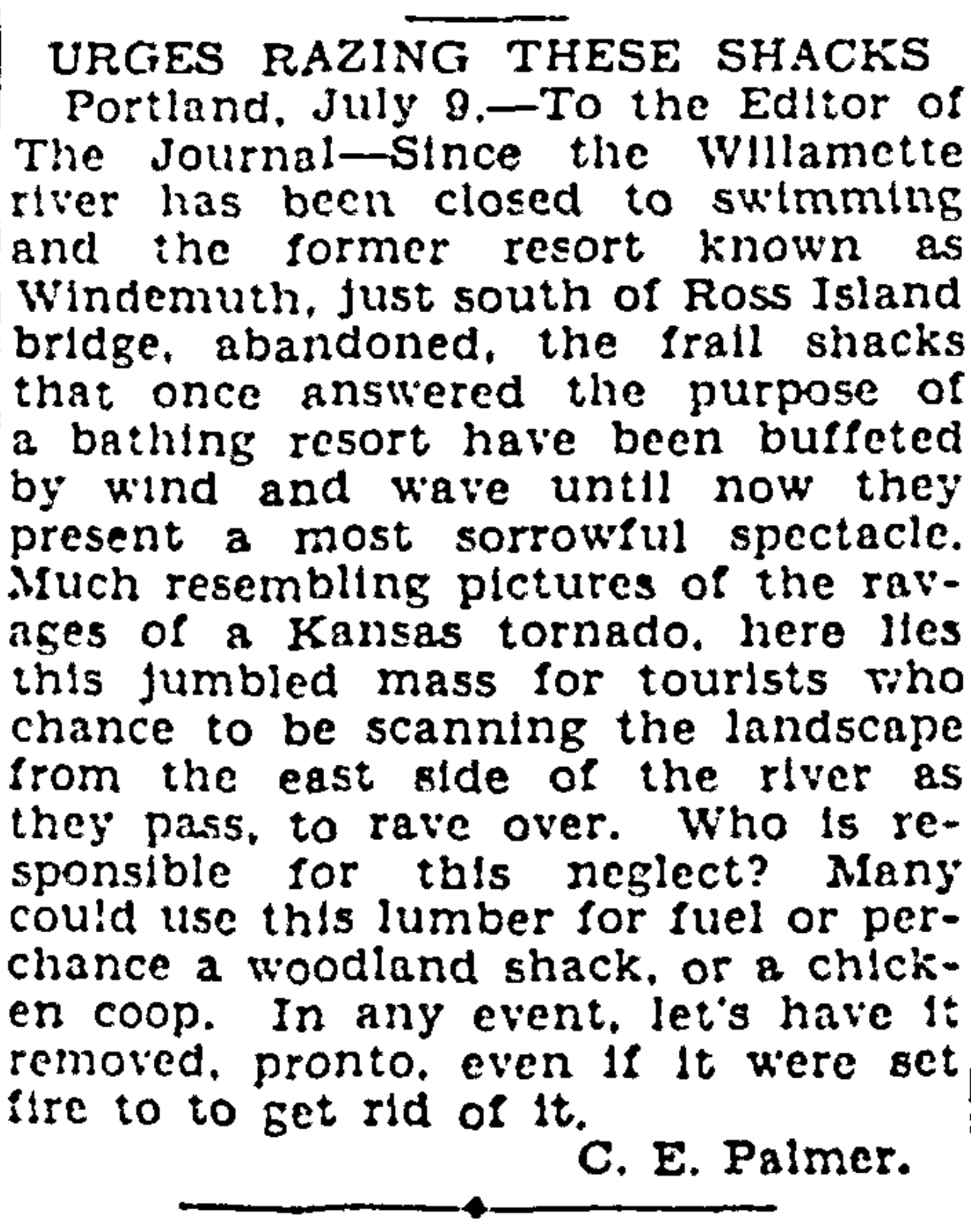
The view from the new bridge down to the former much-loved site of lost Windemuth was a painful a reminder of what had been. This letter writer to the Oregon Journal was tired of looking at it and ready to move on to the next chapter:
Looking southwest at the corner of NE 24th and Fremont, early 1920s. Note delivery bike visible behind power pole. OrHi 49061.
In collaboration with the Alameda Neighborhood Association, I’ll be presenting a local history program Wednesday, March 1st from 7:30-9:00 p.m. at the Fremont United Methodist Church (2620 NE Fremont), and you’re invited (RSVPs required, see below).
Using early maps, documents, photos and newspaper accounts—and memories collected from past residents—we’ll explore how forests and fields defined the landscape of Portland’s eastside. Then, as a young city sprawled across the river, the rural landscape was replaced by a grid of neighborhoods, a busy streetcar system and tens of thousands of new residents. Successive waves of homebuilding and change in the decades that followed shaped the neighborhoods we know today.
This illustrated one-hour program explores the early years of Alameda, Beaumont-Wilshire, Sabin, Vernon, Concordia, and Cully as we examine connections between past, present and future.
To reserve your spot for the March 1 program, e-mail the Alameda Neighborhood Association at alamedanewsletter@gmail.com. Reservation deadline is February 24th. Doors open at 7:00 and the association will have light refreshments on hand.
The Alameda Neighborhood Association is a neighbor-led board that advocates for smart policies, takes action on neighbors’ concerns, facilitates communication about neighborhood issues, hosts events to bring residents together and publishes the quarterly newsletter AlamedaPDX.
Today, we think of the Alameda neighborhood as one contiguous area with well-recognized boundaries: The city’s Office of Neighborhood Involvement identifies Alameda as that area from Prescott on the north to Knott on the south; from NE 21st on the west to NE 33rd on the East. One single named neighborhood today, containing about 2,400 dwellings and more than 5,000 people.
But hiding underneath today’s one single map is a treasure of 23 old maps—subdivision plats—all drawn at different times by different people as they transformed this landscape one small piece at a time from forests and fields to the grid of streets we know today. We’ve been taking a systematic look at these plats, some of which like one particularly chaotic collision just north of Knott, we’ve written about.
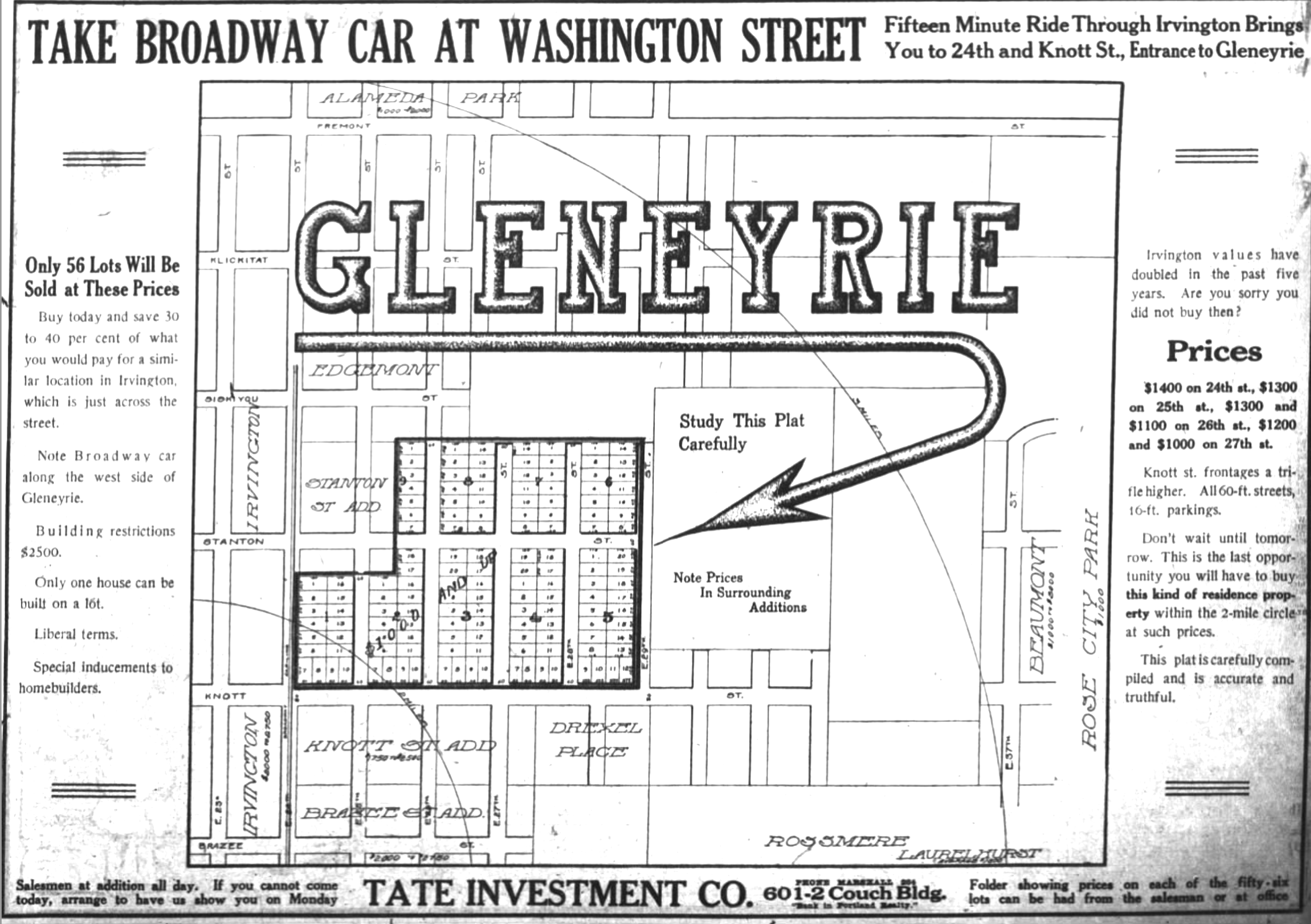
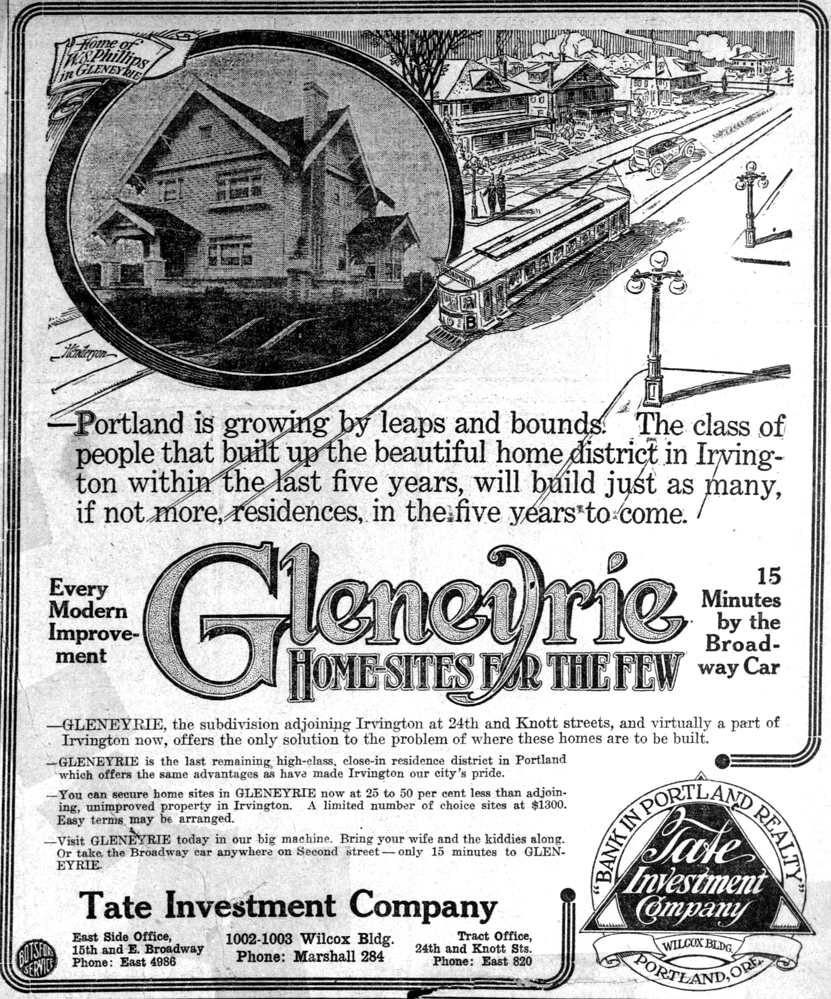
Here’s one we’ve been looking into recently: Gleneyrie, a subdivision plat filed in July 1911 by three couples who were the principals of the Tate Investment Company: Thomas and Inez Foster; Jost and Maria Held; and Robert and Nellie Tate. That fall, they placed their first ad for the property, below, which was then still just a concept (click in for a larger view).
From The Oregonian, October 22, 1911
The Tate Company investors purchased their 24 acres of the former Bowering Homestead Donation Land Claim in the years after the 1905 Lewis and Clark Exposition with an eye toward real estate development. The surrounding open fields, orchards and dairy property were rapidly being converted to residential use to keep up with Portland’s booming real estate market and population. And there was much money to be made by investors ready to speculate on a rising market. The Tate Investment Company also developed Dixon Place, another plat just north of Fremont between NE 15th and NE 21st avenues.
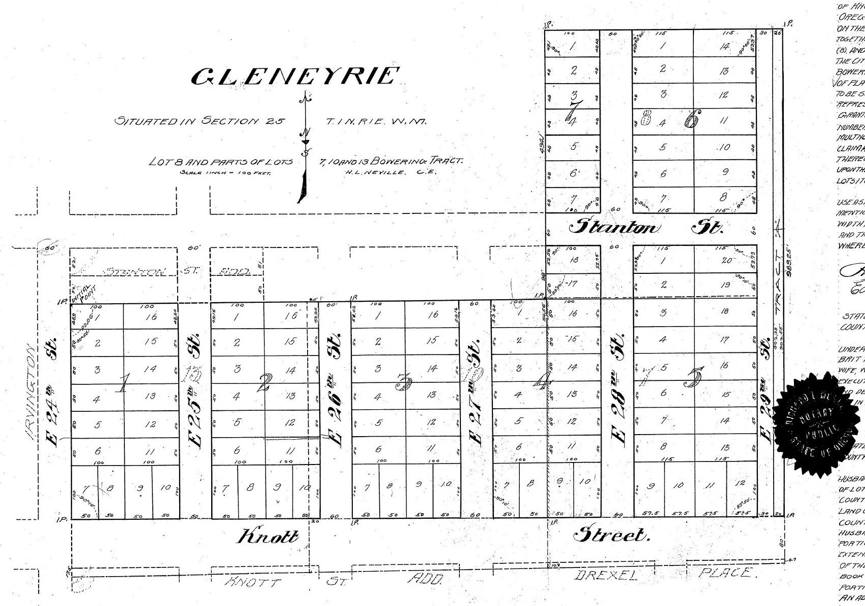
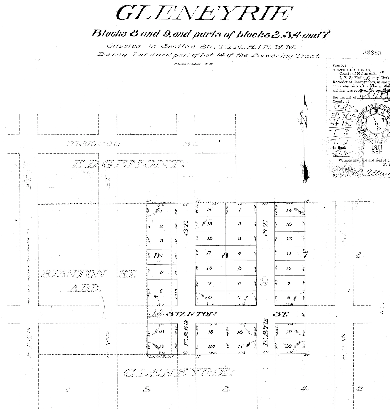
Here’s a look at the official Gleneyrie plat, filed with the Multnomah County Surveyor and County Clerk on July 25, 1911: from NE 24th to NE 29th, between Siskiyou and Knott.
One week later, Tate added additional area to Gleneyrie taking in East 26th and 27th north to the existing boundary on the eastern edge of the plat.
The namesake Gleneyrie was a Tudor-style castle in Colorado built in 1871 by William Jackson Palmer, founder of Colorado Springs: big, beautiful, fancy and well-known. And the name sounded good too, which was key. By 1915, Portland developers had filed more than 900 plats—development plans that divide an acreage into a subdivision of lots and streets—many of which were as small as one block or less, and all named by developers searching for an attractive sounding name.
Today’s Alameda neighborhood is made up of 23 separate plats, all filed at different times by different developers who were competing with each other and speculating on market conditions when they bought chunks of what had been old homesteads and farms claimed in the 1850s and 1860s.
In some areas the plats have retained their distinct personality and name. But here in Alameda—named for the 1909 Alameda Park Addition plat filed just to the north—the identity of the individual plats like Gleneyrie eventually dissolved into the commonly used neighborhood name we know today.
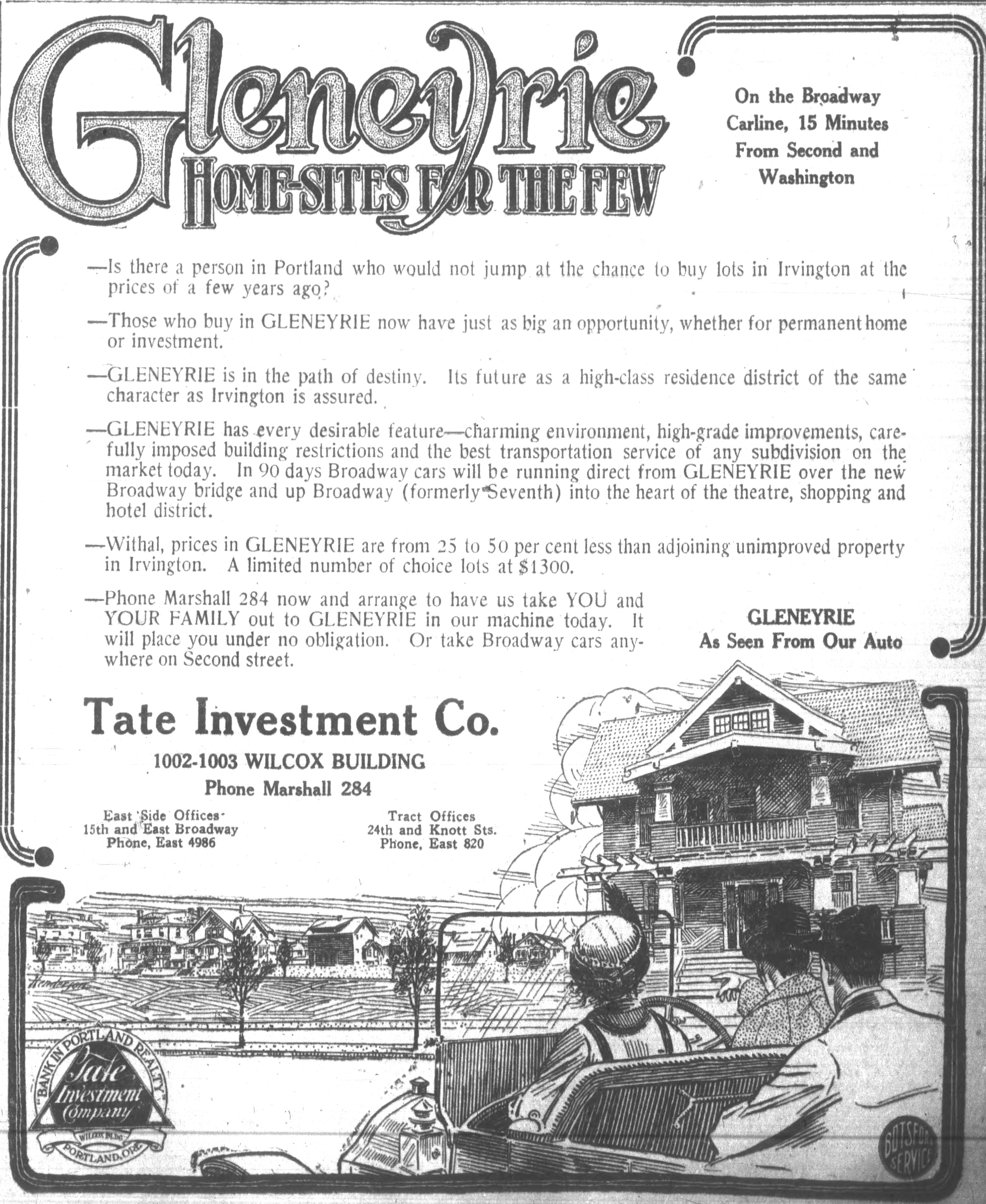
But in the Spring of 1913, when having a catchy name might help compete with all the other real estate advertising, the Tate Investment Company pushed out a series of full-page and half-page illustrated ads in The Oregonian and the Oregon Journal to market the attributes of their new subdivision. And they tied their marketing more closely to Irvington—a well established prestigious brand—than to Alameda, which had just been launched (and was trying to coattail on Irvington as well).
From The Oregonian, April 14, 1913
From The Oregonian, April 20, 1913
While all this advertising was underway, work out on the ground of what was Gleneyrie transformed the property from what were rolling fields into a mostly level subdivision. Significant grading work was done on the property to remove hills and fill in swales and ponds. Newspaper accounts from 1913 indicated 50,000 cubic yards of fill was removed: that’s more than 4,000 modern-day dump truck loads.
One of the leading early builders in Gleneyrie was Arnt Anderson, one of the two-dozen-plus builders we’ve written about on The Builders page. Anderson built some amazing homes that have passed the test of time…before he was arrested, convicted and imprisoned for grand larceny.
Today, ask anyone to tell you where Gleneyrie is and you’ll probably get a blank stare. But back in the day, the folks at the Tate Investment Company were trying hard to make it a household name. Literally.
Wondering about the other 22 plats in today’s Alameda? Here’s the full list: Alameda Park, Homedale, Olmsted Park, Irvington, Edgemont, Pearson’s Addition, Town of Wayne, Town of Wayne Replat, Waynewood, Irvingwood, Meadow Park, Dunsmeade, Irvindale, Hillside, George Place, Gile Addition, Bowering Donation Land Claim Tract, Norton’s Subdivision, Stanton Street Addition, Hudson’s Addition and Meadow Park.
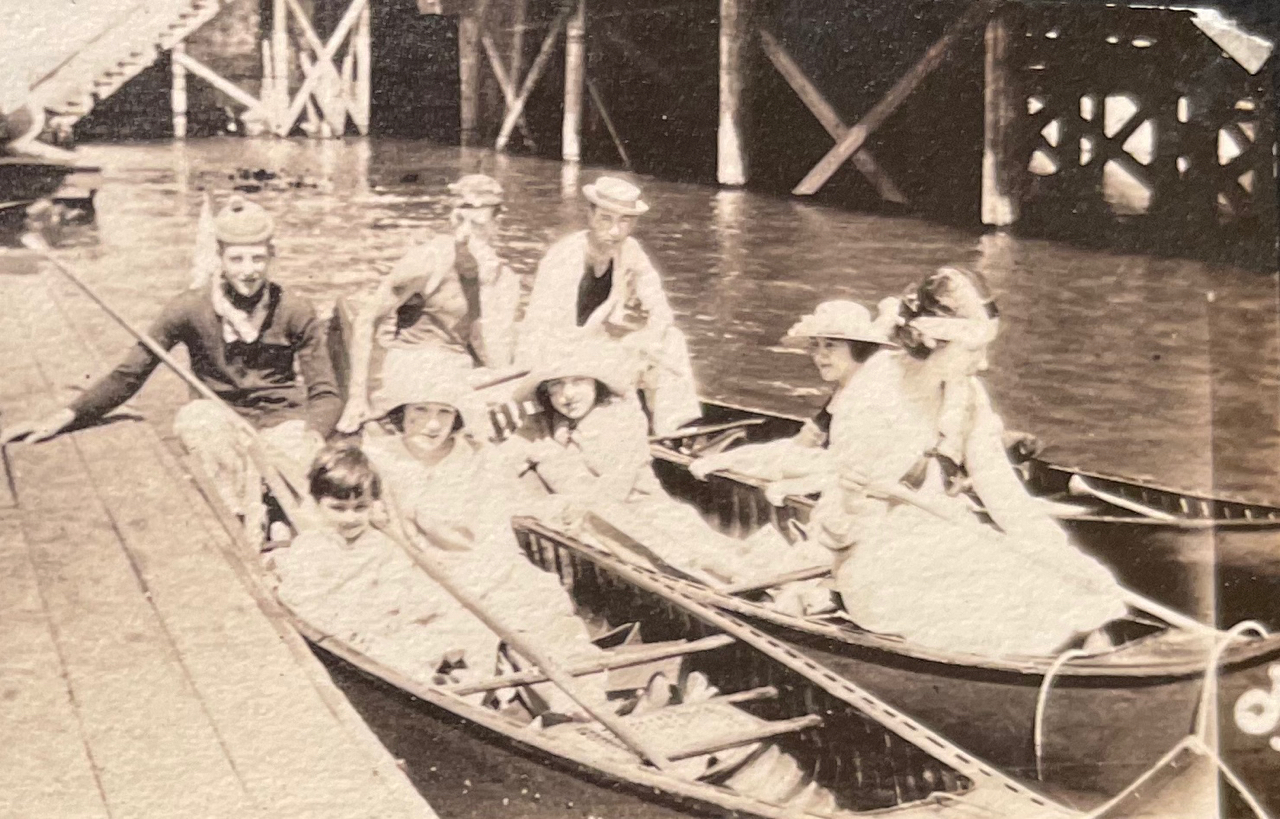
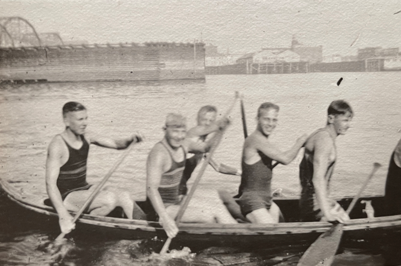
We’ve been helping a long-time Northeast Portland family sort through their 100-year-old photo albums to identify some mystery locations and develop context about important family places. We love working with old photos (there’s a whole category here on the blog called Photo Detective dedicated to the topic which we think makes interesting reading and looking).
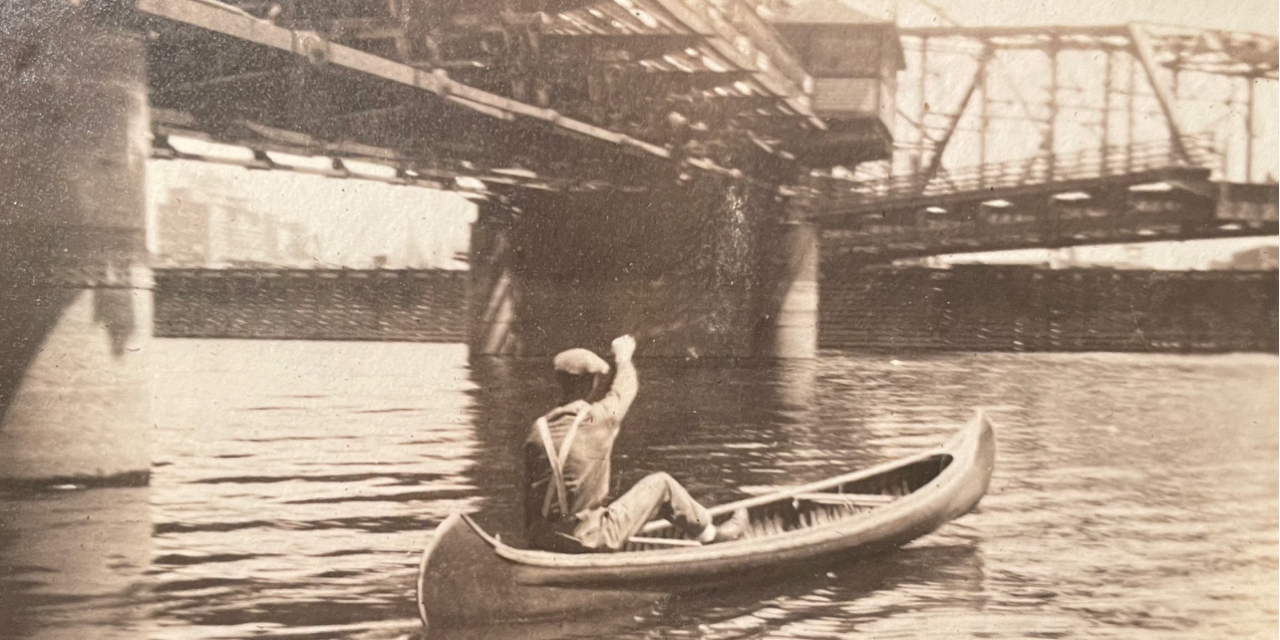
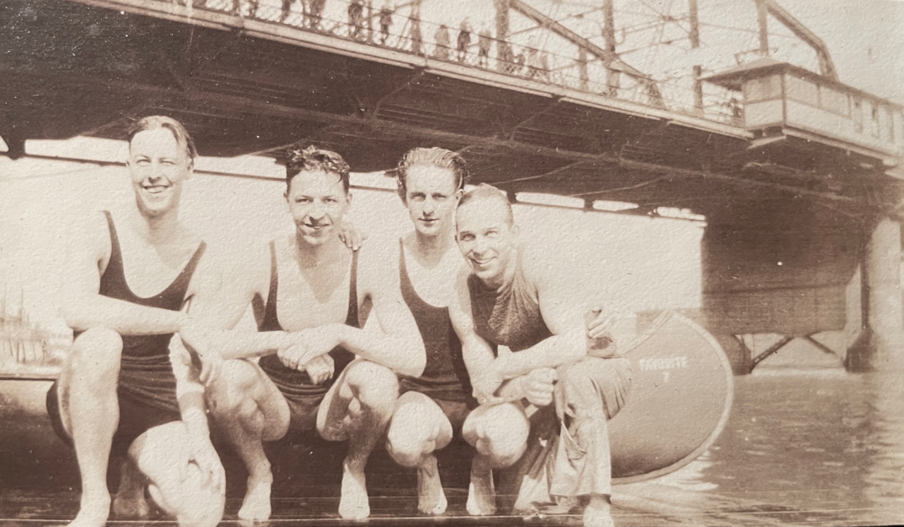
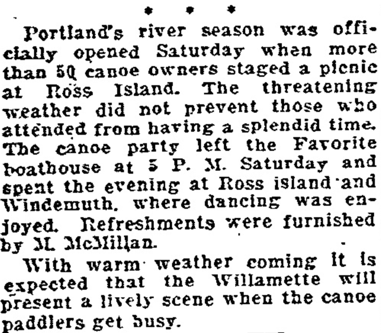
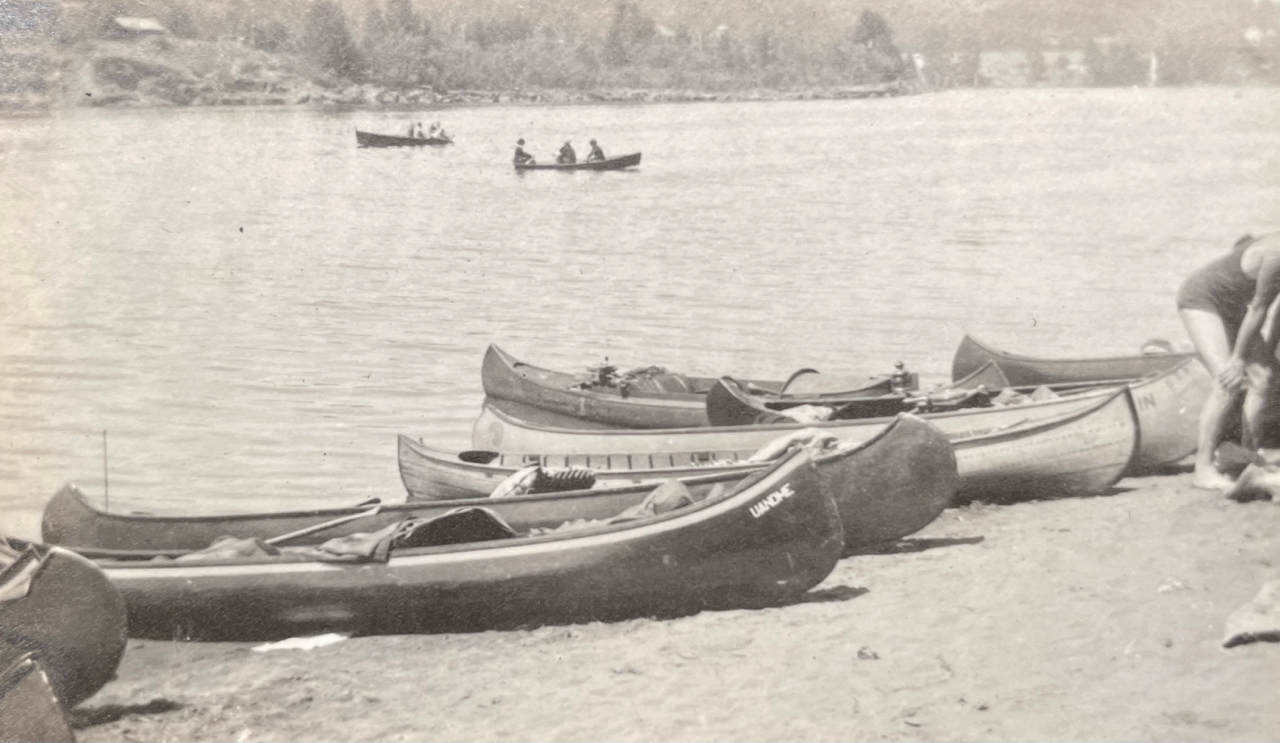
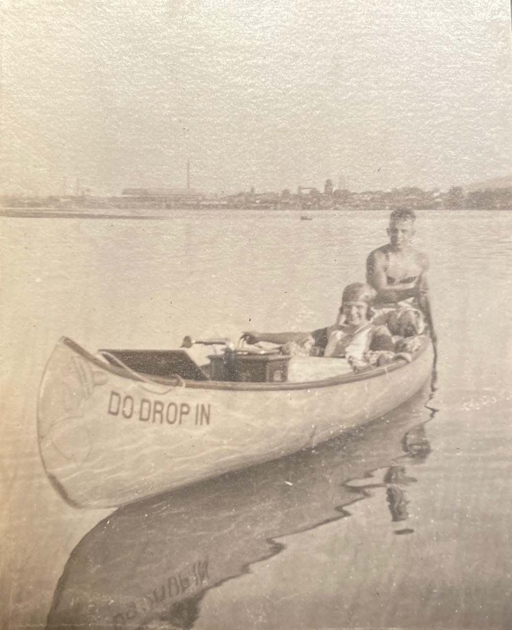
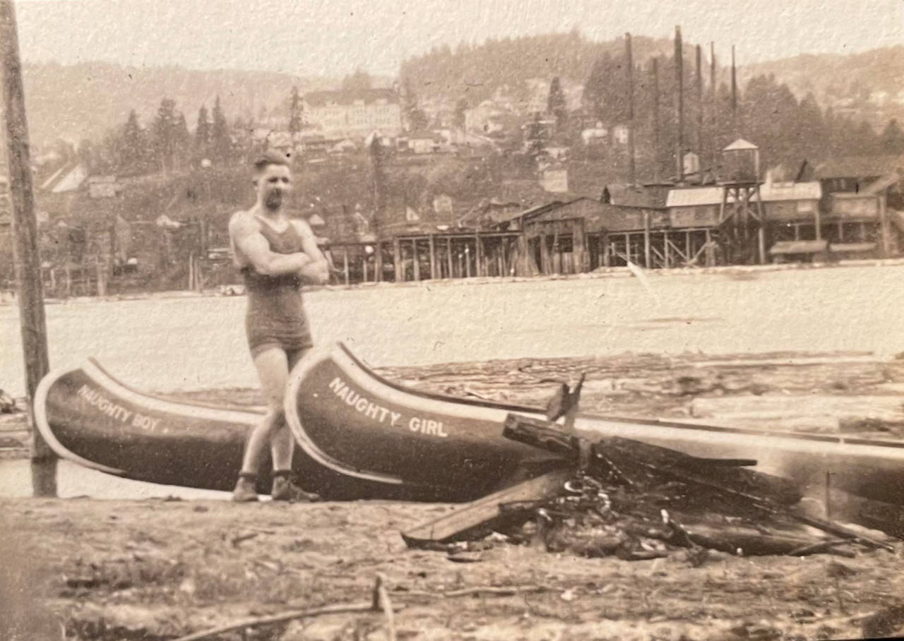
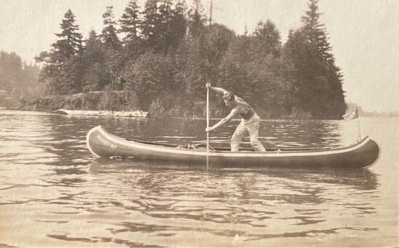
100 years ago, this family loved to play outside and one of their favorite places was the Willamette River between Swan Island and Oak Grove. Like so many young Portlanders of that era, their key to exploring these places was a canoe.
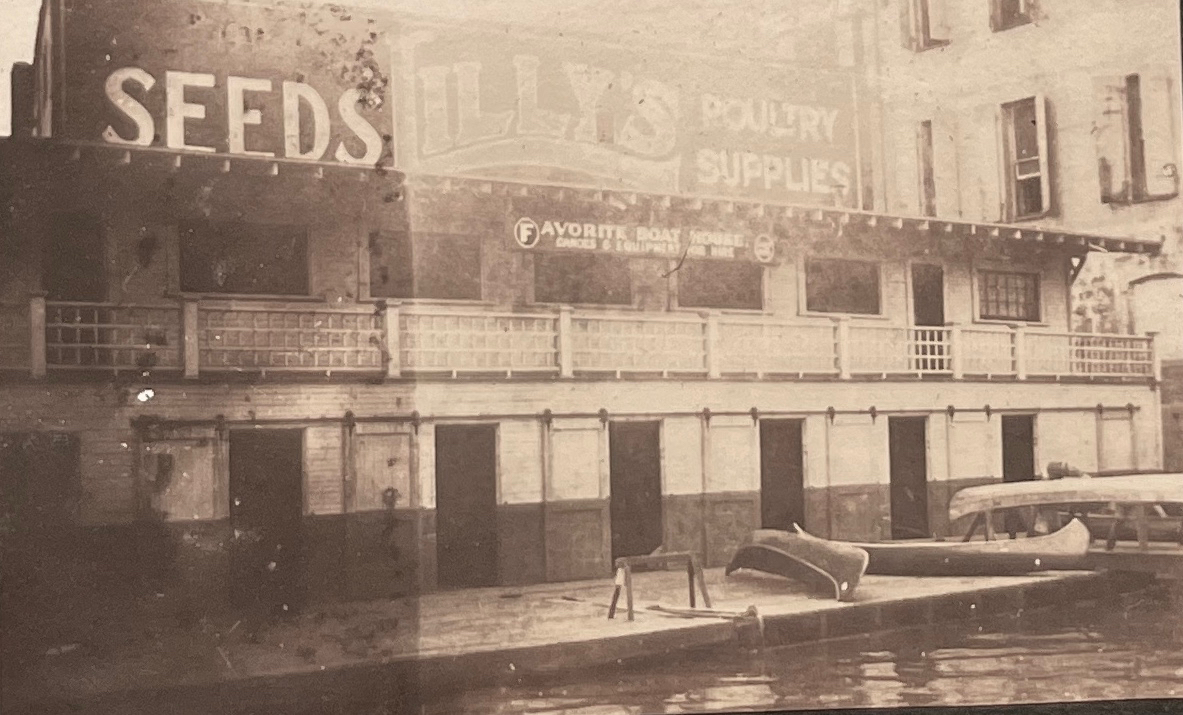
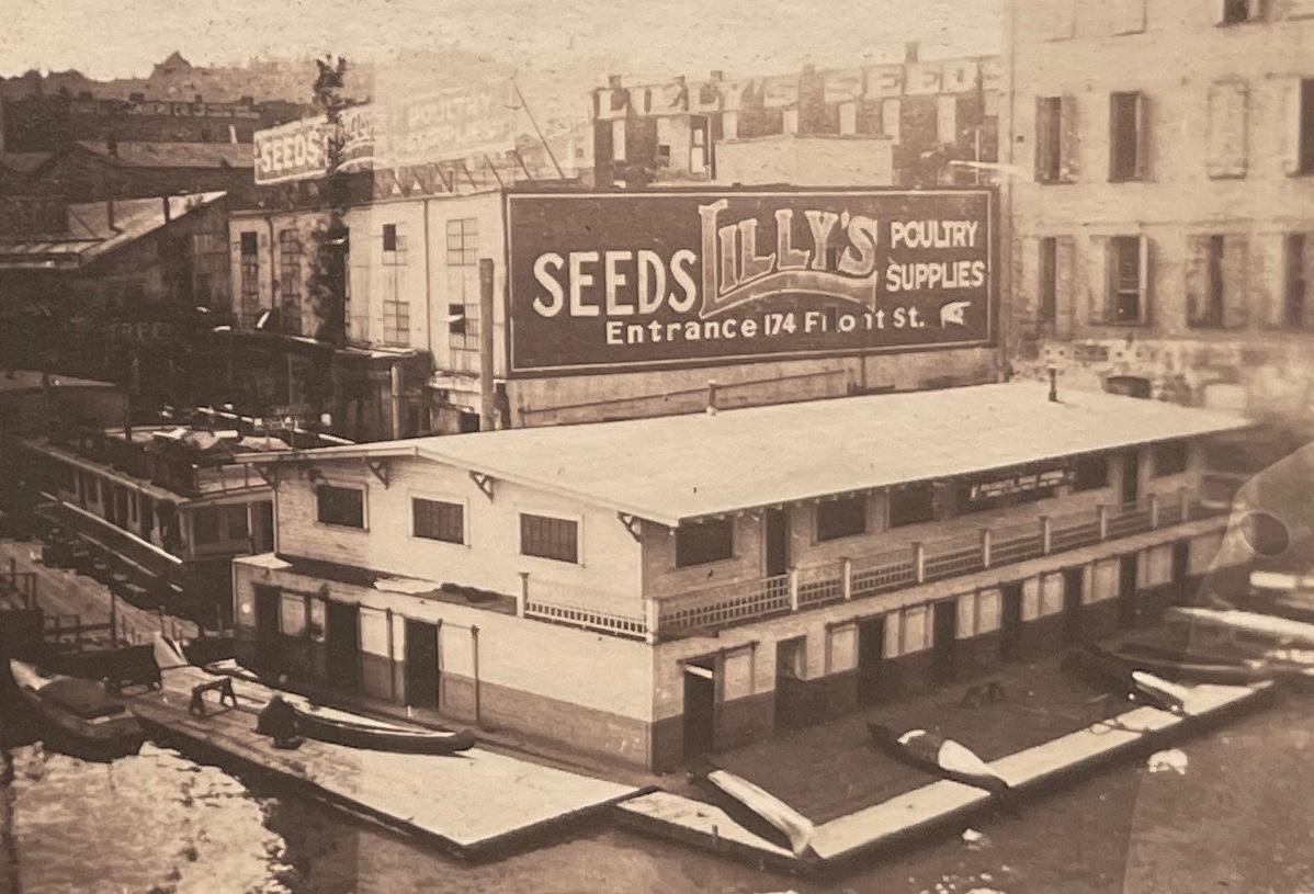
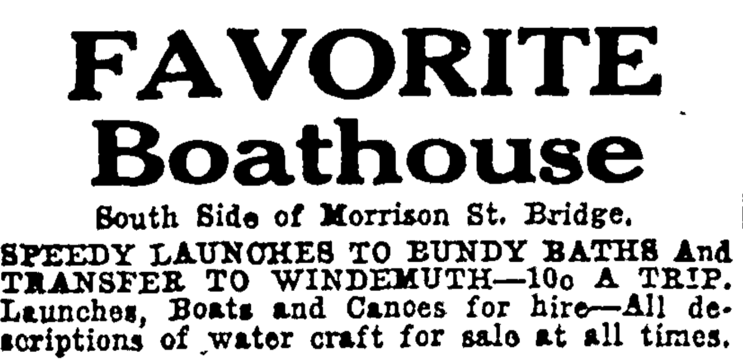
Departing from The Favorite Boathouse under the west end of the old Morrison Bridge, a swing bridge built in 1905 that was replaced in 1958 by the bridge we know today. In the photo above looking to the east, the eastern span of the old bridge is swung open to allow heavy river traffic to pass.
Along with front-porch moments of young families, babies and World War 1 soldiers returning home to Northeast Portland, the albums contain pages and pages of river adventures from the summer of 1919. Since we are frequently in the same waters by kayak and canoe, finding these glimpses struck close to home and got us wondering about the connection between Portlanders and the Willamette 100 years ago. These young people clearly were connected with their river, which looks to have connected them with each other in the special way that rivers do.
A boathouse on the west bank of the Willamette just south of the Morrison Bridge seemed to be at the heart of many adventures, a place appropriately called “The Favorite Boathouse.”
A look through the Oregon Journal and The Oregonian during these years opens a window into just how many young Portlanders took to local waters by canoe. At the time, Ross Island and Swan Island were outposts for recreation (and Swan Island was still very much an island). In 1916, both were destinations for organized outdoor recreation.
From the Oregon Journal, April 20, 1916.
From The Oregonian, April 25, 1921
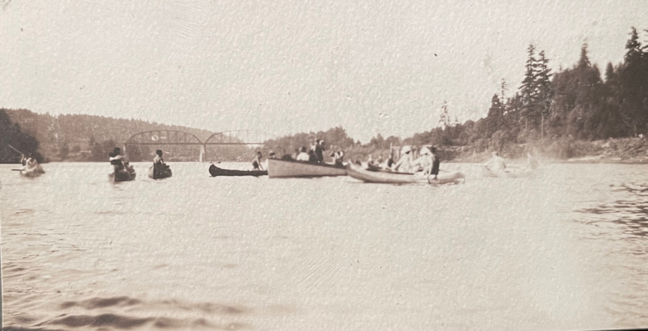
A popular destination for Willamette paddlers in the late 19-teens and early 1920s was Windemuth, a giant floating swimming pool and dance pavilion anchored in the river off the northern tip of Ross Island. By day, Windemuth featured swimming competitions and all manner of water play. By night, hundreds of paddlers arrived to dance on the floating dance floor.
From the Oregon Journal, July 14, 1923
The Favorite and other boathouses rented canoes for couples and groups to paddle upstream to Windemuth for the summer evening dances. If you didn’t want to paddle, you could pay to ride a scheduled “motor launch” from downtown. Or from the eastside, you could take the Brooklyn Streetcar to the foot of Woodward Street and catch a short boat ride across to the floating pavilion.
Unfortunately (and not surprisingly) there were frequent swampings of canoes from the wakes of the many steamships active in Portland harbor, and regular drownings, often at night, coming and going to the islands.
From The Oregonian, May 14, 1923
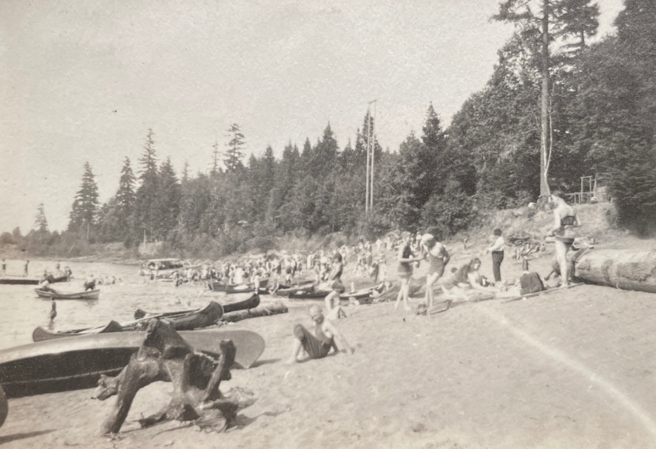
On Swan Island north of downtown, the beach in summer was filled with canoes that brought young Portlanders over the waters to sunbathe, picnic and camp.
Looking toward downtown from near the beach on Swan Island. Note the Victrola record player in the front of the canoe. The Victrola and its records, picnic boxes, bags of clothes and camping gear show up as payload in multiple photos. Summer 1919.
Handed down family stories describe young people swimming among and playing on the many rafts of logs that were tied up along the Willamette banks awaiting use by local sawmills. During these years, log rafts lined both shores from the Sellwood Bridge to St. Johns.
Taken on the western shore of Swan Island looking to Portland’s west side, with two canoes. The sawmill on the far side of the river is the Northern Pacific Lumber Company mill located in the vicinity of today’s Terminal 2 on NW Front Avenue. The very large building in the background is the old St. Vincent Hospital located on Northwest Westover. A log raft is visible anchored just off the near shore behind the canoes. Summer 1919.
Family members enjoyed paddling farther south, around the Milwaukie bend at Elk Rock Island and upstream under the Union Pacific Railroad Bridge at Lake Oswego to the vicinity of today’s River Villa Park, a nice six-mile paddle from the northern tip of Ross Island.
Elk Rock Island, Summer 1919
Looking north toward the Union Pacific Railroad Bridge at Lake Oswego (built in 1910), which is still in use and marks the northern edge of today’s River Villa Park in Oak Grove.
But by the mid 1920s, Portland’s recreational relationship with the river was about to take a major turn, due to health concerns resulting from the reality that the city’s raw sewage went straight into the river.
From the Oregon Journal, July 31, 1924
The shutdown relegated moonlight canoe trips to wistful memories a generation later. Below, from the Oregon Journal, May 5, 1946.