Earliest span over mid-Sullivan’s Gulch: the 28th Street Trestle

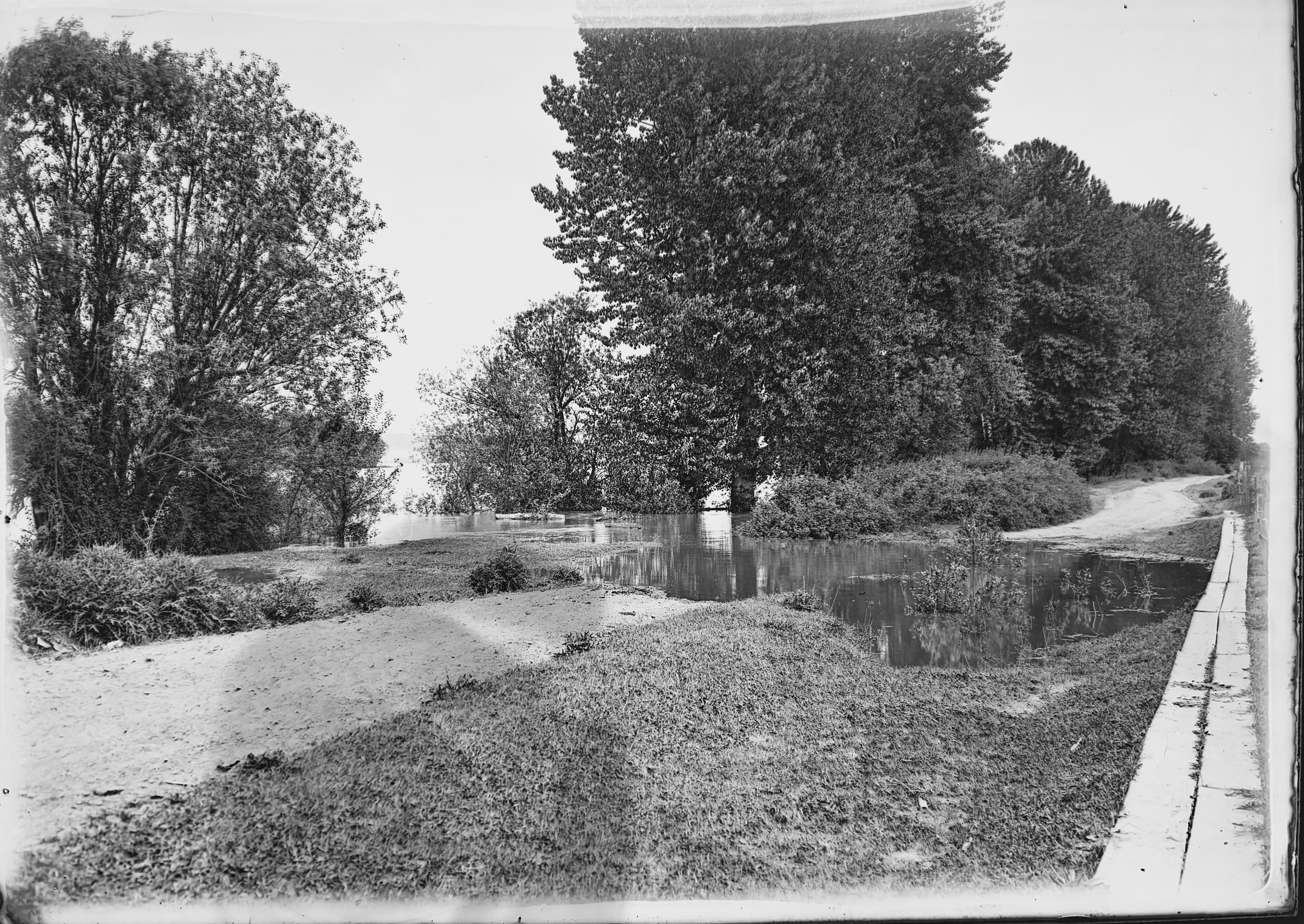
A friendly reader has shared a photograph from her great-grandparents’ photo album and wondered about where it was taken, when, and what it depicts. We love a good photo detective mystery like this, which enables a deep dive back into the landscape of the 1900s. Have a good look at it for detail, and then we’ll discuss:

Courtesy of Phillips Family Archive

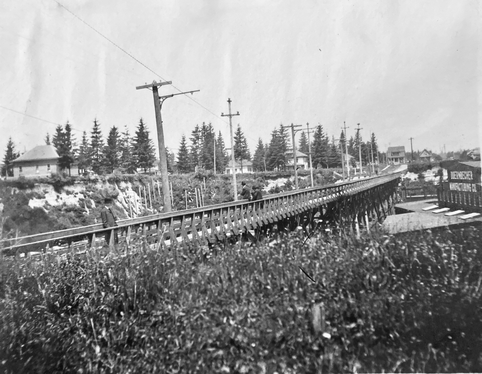
You’re looking north at a newly-completed wooden streetcar and pedestrian trestle bridge over Sullivan’s Gulch (where today’s Banfield / I-84 runs) at about NE 28th Avenue, just south of today’s Hollywood West Fred Meyer. The trestle existed for only a short time–from 1903 to 1908–before pressures from a growing Portland replaced it with a concrete span, which was later echoed by new bridges at NE 21st and then at NE 33rd. Its short lifespan says so much about development about this part of the city during the years immediately after the Lewis and Clark Exposition, which ushered in waves of change for Portland.

But first, the trestle: 800 feet long, an average height over the ground of 35 feet, costing $2,000 to build, including simply a rail line and a narrow sidewalk on the east side of the span. Built between November 1902 and January 1903 by the City & Suburban Railroad, one of the several streetcar companies that served Portland during those years, later subsumed into the Portland Railway Light and Power Company system.

And here’s where it gets interesting: City & Suburban built the trestle under contract to the Doernbecher Manufacturing Company, a furniture factory, which was Portland’s largest private employer at the time and which operated a sprawling five-acre factory site at the bottom of the gulch just beneath the trestle. Thousands of workers made the trip into and out of the gulch each day and having a means of easy access was helpful for the company, which had opened the factory just a few years earlier in 1899. If you haven’t heard about the factory, you can read more and see photos in this piece, which was the second installment of a series we’ve written on the history of Sullivan’s Gulch. Today’s giant U-Store storage complex is the skeleton of what once was Doernbecher Manufacturing.

City & Suburban Railroad operated the East Ankeny Line, which terminated in the streetcar barns that once stood near NE 28th and Couch, about a mile due south. For the executives at Doernbecher, it was an obvious proposition to pay the railroad to extend its line north straight up 28th, build the trestle and two prominent stairways down, so workers could come and go conveniently. Meanwhile, City & Suburban was also eyeing service to the neighborhoods taking shape to the north of the gulch, and the possibility of a loop with the existing streetcar service that ran up Broadway into Irvington and later Alameda.

And so it was in August 1902 when construction of the line extension began:

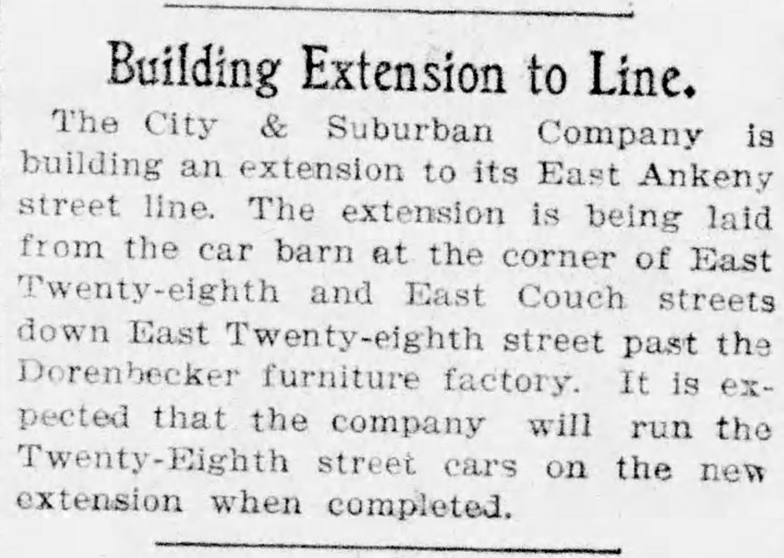
From The Oregon Journal, August 19, 1902

By November, the extension was in and grading was underway at the lip of the gulch to prepare for the trestle. Wood was being stockpiled for construction:

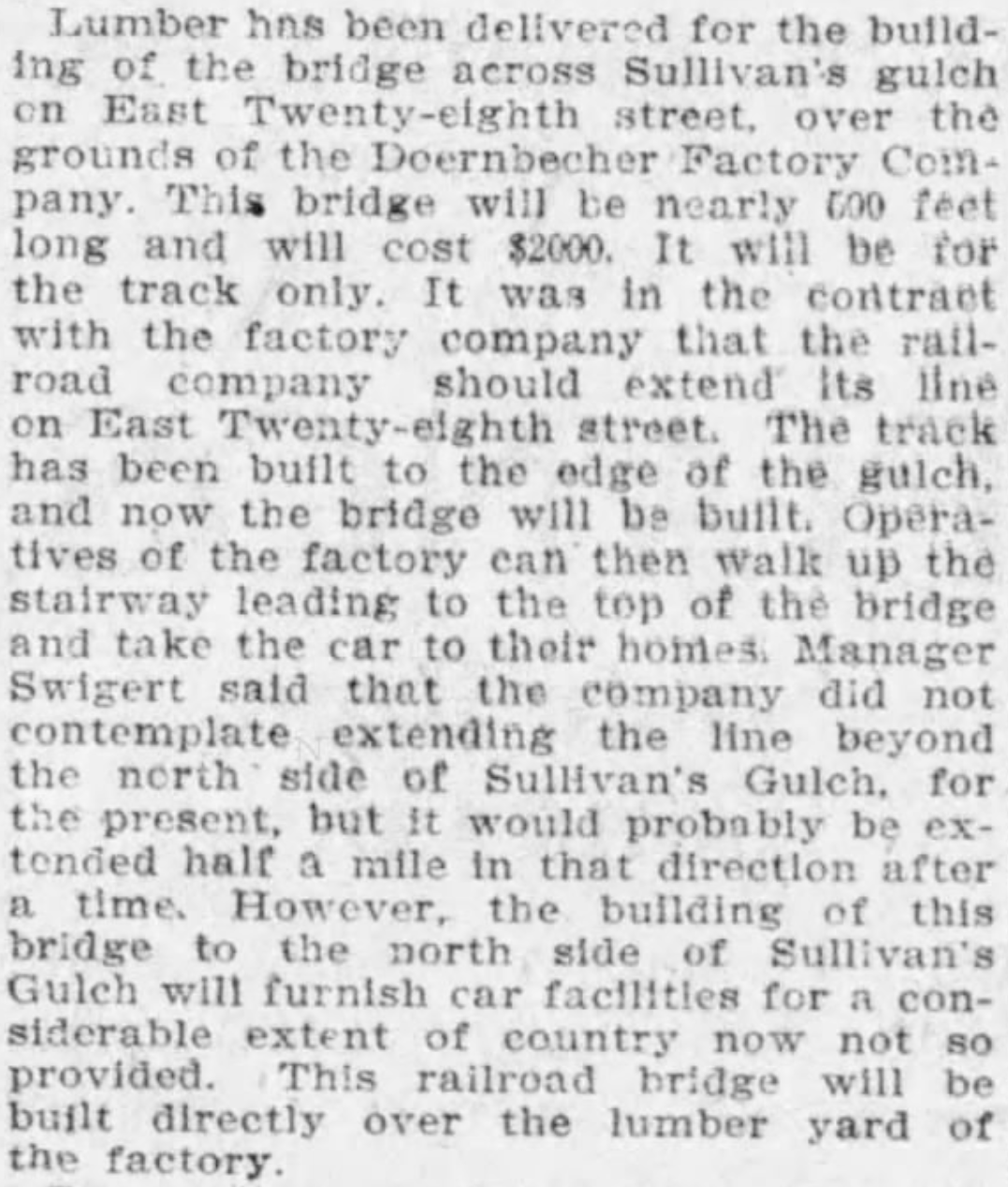
From The Oregonian, November 12, 1902

Trestle construction began in earnest in December and was completed in January. Later that year, the East Ankeny Line was extended a bit farther north to an end-of-the-line stop at NE 28th and Halsey. The envisioned loop with the Broadway Streetcar never materialized.

The trestle enabled a broader infrastructure that began to serve middle Northeast Portland. In November 1903, an 8-inch water main was secured to the wooden structure carrying public water for the first time into this part of the city:

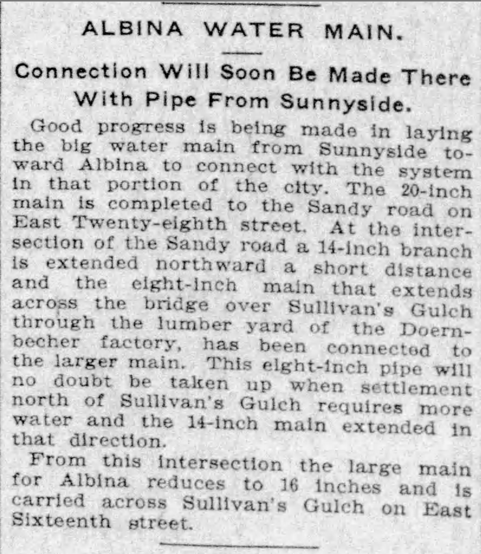
From The Oregonian, November 5, 1903

In 1907, following the Lewis and Clark Exposition and with home construction and residential land speculation fever running high, residents of the area began to lobby for a wider multi-use crossing of the gulch in this area. The trestle was replaced in 1909 by construction of a concrete viaduct.

The story of sleuthing the photograph is interesting too:

  1. We knew the Doernbecher story in this location, and could see the “Doernbecher Manufacturing Company” painted on the side of the building in the photo. The alignment of the Doernbecher building, slightly angled to the crossing, is still evident today in what may well be the very same building.
  2. The homes pictured at the edge of the gulch, several of which are still standing today along NE Wasco and Multnomah streets, provide a tell-tale indicator this view looks north.
  3. The Sanborn Fire Insurance Map from 1909 also helped, lining up nicely with the Doernbecher lumberyard seen in the old photo through the rungs of the trestle railing and mentioned in the news stories. Knowing the buildings were to the right (upgulch) and the lumber yard was to the left (downgulch) also confirmed direction of the view.

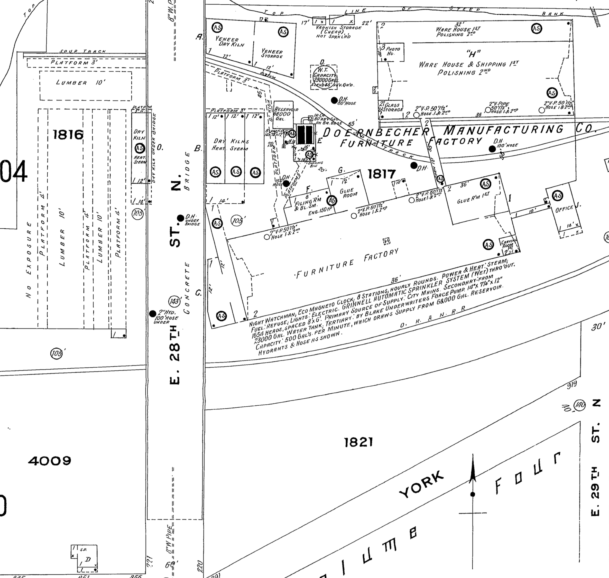
Detail from 1909 Sanborn Fire Insurance map.

  1. The Sanborn also shows the Oregon Railway and Navigation mainline (much later the Union Pacific) which travels through the gulch and was the reason Doernbecher cited the factory there in the first place. The bowler-hatted gentlemen on the trestle walkway are probably looking down as a freight train passed by underneath. Look carefully and you can see the electric and telegraph lines that followed the tracks running perpendicular to the trestle in the mid-ground. The 1909 Sanborn shows the concrete bridge which replaced the trestle.

Do you have old photos you’re trying to make sense of? We’re always glad to help.

Columbia Slough 1913

In December we discovered and shared here a trove of glass plate negatives taken by a photographer from the Department of Public Works who was out to document the giant gravel pit at NE 33rd and Fremont.

In that same series of glass negatives we found one labeled “High Water Columbia Slough,” clearly shot at a different time of year (the trees are leafed out), but contemporary with other images in that collection from 1911-1913, showing a finger of river overflowing its banks. Trees in the mid-ground are standing in water. A gravel road is inundated, but a plank walkway allows foot passage. Off behind through a curtain of brush is open water, an island in the distance, the far shore in the distance beyond that.

Columbia Slough High Water, courtesy of Portland City Archives. Image A2009.009.2791

We’ve been staring at this photo, like we enjoy doing with all old photos, trying to understand what it has to tell us, where it was taken and its overall context.

We’ve written about the slough here on the blog, also known as the Columbia Bayou on some maps and as “the bottoms” in surveyors notes from the 1850s, and shared some views taken about this time and a bit earlier. In other work, we’ve learned about the conversion of the slough for grazing and agriculture, and later for flood control and irrigation. When this picture was taken, big changes were on the horizon that would eventually lead to a transformation of the Columbia River’s south shore in this area bringing hundreds of thousands of cubic yards of fill, a levee system, construction of the Portland Air Base and later Portland International Airport.

But back in 1913 when this photo was taken there was still living memory of a very different time, of the first people who made their lives and livelihood on these banks, of a river that rose and fell, with waters regularly filling as far south as today’s Columbia Boulevard.

As to where this was taken? Starting with the easy assumptions, we believe it’s looking upstream to the east, the mainstem of the Columbia in the middle distance. The large-format camera used to make this glass negative would have been a heavy thing to lug around, so chances are it’s not too far from where the Public Works Department could drive.

A look at the 1897 USGS Portland quadrangle map above, and the 1915 Hanson and Garrows Map of Portland, suggests it could have been at the far north end of NE 33rd (known in that area as Sunderland Road), or north of Cully Boulevard, both places where small networks of temporary gravel roads wove around slough waters. Check out the map, with some new labels added for orientation and a few possible photo locations circled in red, just for fun. While you’re looking around, appreciate just how complex and amazing the slough was. During high water on the Columbia, all those channels and ponds and the wet meadows in between were submerged.

Back to the 112-year-old photo: it’s a pretty interesting image of an extinct location reminding us of our short time here, and the changes we’ve wrought in just over 100 years.

Epilogue: Gravel Hill 25 years later

It’s been like time travel, studying the discovered photos from 1913 that take us back to the intersection of NE 33rd and Fremont, the giant gravel pit that once defined that hillside, the stairs leading up Alameda Ridge, and the unstable cutbank above Fremont.

Here are two more views of the general vicinity taken 25 years later that show us how the slope was settling after being filled with garbage and soil. Photographed by the Public Works Department on November 21, 1938, these views look uphill and downhill on 33rd from just below the top of the hill. Click in for a good look and then we’ll discuss:

Looking north along the west side of NE 33rd, just downslope from NE Fremont. Image A2009.009.1272, courtesy of City Archives.

Looking south along the west side of NE 33rd, just downslope from NE Fremont. Image A2009.009.1271, courtesy of City Archives.

Judging by the sunlight and shadows–and what looks like an exodus from Grant High School–these photos were taken in the afternoon of that November day. The uphill photo shows just how much the mid-slope has settled, with the curb and street surface buckling and the entire sidewalk heaving to the west. Nothing has been built on these vacant lots, probably because they were still settling.

Look a bit farther up the hill and you can see two brand-new Ken Birkemeier houses at far left (3279 NE Fremont), perched on what had been the cutbank, and the bungalow to its east at the corner (3289 NE Fremont). Across the street farther east you can see the high-peaked roof of the home at 3304 NE Alameda, and the distinctive tile roof of the Mediterranean-style house at 3301 NE Fremont.

Also interesting to note: no signal light controlling the intersection, nor is there a stop sign facing 33rd (can’t read what is on that sign, but it’s not the standard octagonal STOP sign we know today, which was in common use by 1938). Perhaps Fremont had the stop sign and 33rd had the right of way.

Yet to be built at the top of the hill on the southwest corner was a mid-century home and swimming pool that would eventually collapse into the old pit area and be replaced in the 1990s by a much larger house (and geotechnical engineering). We wrote about it here: The lost house at 33rd and Fremont.

The downhill photo looking south shows just how much the sidewalk wants to fall off into the old pit. Below the pedestrians you can see a house under construction–3289 NE Klickitat, also by Ken Birkemeier who was very busy in this part of the neighborhood during those years.

Today we have Google streetview to document so many aspects of our neighborhood, but it’s been a treat to turn back the clock with these and the 1913 photos. We’re always on the lookout for early photos of our Northeast neighborhoods. Stay tuned for more findings. The promised Columbia Slough photo from 1913 is next.

Post Script: Attentive Reader John Golightly adds his observations that the sign at the intersection probably was a “SLOW” sign, which we agree with. Here’s a photo of a 1930s-era slow sign in its characteristic diamond shape:

1913: Hillside above Fremont on the move

In 1913, nearby property owners and the Department of Public Works were concerned about the stability of the slope above Fremont Street in the stretch between NE 30th and NE 33rd. Fremont itself was perched along the north edge of a giant gravel pit that had been mined for decades and would eventually be filled with garbage to build it back up to grade.

NE Fremont Street looking east near today’s 32nd Place, in 1913. Click in for a closer look. Gravel pit to the right (south) and cutbank above to the left (north). House in the center is 3415 NE Fremont. In the distance, sewer pipe is stacked down the hill along the east side of 33rd and a person faces the photographer at the intersection. A wooden plank sidewalk runs along the south side of Fremont. The gravel and dirt streets were paved the following year. Photo courtesy of City Archives, A2009.009.3615.

The cutbank slope above Fremont angled up 50-75 feet to the southern edges of the brand-new Alameda Park and Olmsted Park subdivisions, which flattened out to the north atop Alameda Ridge. With nothing to hold the cutbank in place, dirt and gravel would periodically slide down, covering sidewalks and curbs and spilling out onto Fremont Street.

A Department of Public Works photographer was there to document the slope. These are the last three in the series we’ve been sharing of re-discovered images at City Archives that are labeled as “Lombard Street.”

Moving farther west on Fremont, the photographer noted two other slides that had covered sidewalks and curbs.

NE Fremont Street. Looking east just below the crest of Alameda Ridge, seen from between today’s NE 32nd and NE 31st. Photo courtesy of City Archives, A2009.009.3616.

Fremont Street running left and right, seen from the corner of NE 31st, which leads downhill at bottom right. Looking northeast toward the top of Alameda Ridge. Photo courtesy of City Archives, A2009.009.3618.

Be sure to take a look at this view as well, a low-elevation oblique photo from 1930 that shows the cutbank, the slope below Fremont (now filled with garbage and grown over with brush) and lots of other neat things to look at.

No big surprise both slopes were on the move. Geologists remind us Alameda Ridge is basically a giant gravel bar, deposited more than 15,000 years ago by the great Missoula floods that shaped our region. In the years after these photos were taken, vegetation returned to the cutbank slope and houses (and stairways) were built, increasing the surface stability.

Attentive reader and friend of Alameda Brian Rooney tracked down a great graphic that shows the east-west pendant gravel bar of Alameda Ridge that formed downstream (west) of Rocky Butte during the great floods. Helps visualize the old “Gravelly Hill” ridgeline. The arrow points out the intersection of 33rd and Fremont:

A detail from a comprehensive poster explaining the Missoula Floods by the Oregon Department of Geology and Mineral Industries. Thanks Brian!

Up Next – A bonus photo from Public Works: the Columbia Slough in 1913.

1913 Photos: Dueling Subdivisions at NE 33rd and Fremont

To really understand the next installment of photos from the 1913 collection, it helps to visualize what the middle part of Portland’s eastside looked like then, and what was going on in the economy and life of the city. Following the Lewis and Clark Exposition, which put Portland on the map in so many ways, our population exploded: from 90,426 people in the 1900 census, to 207,214 by 1910.

Like shock waves rippling out across what had been a mostly agricultural landscape, development pressures began to reshape the dirt roads, orchards, dairies and forested clumps of the middle eastside. Meanwhile the economy began to heat up in the early teens as speculators, home buyers and homebuilders jockeyed to take advantage of the growing marketplace. Maps and a few precious photos from the early 1900s show this place as mostly undeveloped open lands, dotted with barns, scattered farm houses and dirt roads.

By 1913, the fields and hills of the middle eastside had been platted out into subdivisions, and the infrastructure of sewer, water, electricity and roads was trying to catch up with the vision sold by developers. In some places, a grid of streets existed, and a sprinkling of single family homes was being built, making visible the conversion from agriculture to residential use. To the north closer to Alberta, construction had been underway since the middle of the 00’s. Eastside neighborhoods closer to the river–Albina, Irvington, Ladd’s Addition, Woodlawn, the Peninsula–had been platted and growing as early as the 1890s.

Back in the day, the intersection of NE 33rd and Fremont–the focal point of this 11-photo series of glass plate negatives from City Archives–was a north-south wagon road to the Columbia River, and access point for the giant gravel pit near the top of the ridge. Surrounded on all sides by planned development, the intersection was in transition from dirt path to thoroughfare.

On the northeast side of the intersection, the Jacobs-Stine Company was ready to sell you a lot in the Manitou Subdivision. Just across Fremont to the southeast, the Terry & Harris Company wanted you to see the lots in Maplehurst. Our photographer from the Department of Public Works captured both views. Meanwhile, the mud puddle in the middle of the intersection reminded everyone the reality that for the moment, this was still a fairly rural place.

Looking to the northeast along Fremont from the southwest corner of NE 33rd and Fremont (33rd is passing from upper left to lower right). The house in the distance at right is today’s 3415 NE Fremont (built in 1912). Curbs and sidewalks are in (thanks to Elwood Wiles and Warren Construction), and ceramic sewer pipe is stacked near the curb awaiting installation. The Jacobs-Stine Company, boasting on its sign of being “The largest realty operators on the Pacific Coast,” was owned in part by Fred Jacobs, who would later die when his car tumbled off Stuart Drive in Alameda a few blocks from here, giving rise to the nick-name of that street as Deadman’s Hill. Photo courtesy of City Archives, image A2009.009.3613.

Looking to the southeast from the northwest corner of 33rd and Fremont. 33rd runs down the hill on the right. Fremont follows the slight rise to the left as it heads east. Sewer construction is evidently about to begin. Photo courtesy of City Archives, image A2009.009.3614.

Left photo is similar to top, looking northeast. Right photo is similar to bottom, looking southeast.

Maplehurst was platted in 1910 by Mary Beakey, who named a street for her family (labeled as A Street on the plat). It’s a relatively small subdivision–only three blocks and 43 lots, and exists up against a plat called Irene Heights, which was developed by the Barnes family, containing the Barnes mansion and multiple former Barnes family homes.

NE 33rd wasn’t the only north-south thoroughfare passing through a landscape in transition. One half section to the east (our landscape was gridded into sections, townships and ranges by surveyors in the 1850s), NE 42nd Avenue was experiencing its own growing pains.

Up next: The Alameda stairs. Our Department of Public Works photographer captured the brand-new stairways transiting the slope between Fremont and Alameda Terrace (known as Woodworth before the Great Renumbering of the early 1930s).

1913 photos reveal new perspective at Gravelly Hill – 33rd and Fremont

Every now and then in my research, I’ll find something—a memory, photograph, map or  document—that really sticks with me and defines the way I think about a place.

This month I found a batch of mis-identified photographs when searching at City of Portland Archives that resulted in an absolute jackpot from 1913, opening a fresh window into the past near NE 33rd and Fremont.

Once known as Gravelly Hill, the area was indeed a gravel pit for many years in the late 1800s, and later the repository for all of the eastside’s household garbage between 1923-1924, then known as the Fremont Sanitary Landfill.

But before the landfill, back in 1910 as subdivisions crowded in around the big pit, questions were raised about the basic stability of Fremont Street, which was just below the brow of the Alameda ridge and ran right along the north edge of the pit. Developer Benjamin Lombard, who platted the adjacent Olmsted Park about that time, even sued the city for violating its own ordinance about gravel pits.

So, no secret: that slope South of Fremont was a gravel pit.

But as it turns out, it wasn’t just a gravel pit. It was a GIANT gravel pit. See for yourself:

You’ll want to click into this for a good look. Looking east along Fremont toward NE 33rd from about today’s NE 32nd Avenue. Sewer pipe stacked along the eastern edge of NE 33rd, which slopes downhill left to right. The roof of the house visible at treeline in the center is the Barnes Mansion, 3533 NE Klickitat, which was then brand new. City Archives Photo: A2009.009-3611 (mislabeled as Lombard Street)

In 1913, a photographer for the Department of Public Works visited the pit and brought back 11 amazing images that got buried in the archives. They’re large-format glass plate negatives, not prints, and for years have been filed away in envelopes under “Lombard Street” at City Archives. I suspect few people have ever seen them. A few weeks back, something else I was looking for led me to these glass negatives.

I photographed each plate and made positive prints to be able to better visualize the scenes. And as I studied that first picture and figured out it wasn’t showing Lombard Street, but Fremont Street, I knew this would be a find to remember.

After that first photo, there were these next two, clearly taken as a pair, to illustrate the depth and breadth of the pit. Both are unquestionably tied to the Gravelly Hill landscape. Here I’ve melded them together to create a single image:

Looking north into the gravel pit at NE 33rd and Fremont, December 1913. Click to enlarge. View would be from between today’s Siskiyou and Klickitat streets, looking uphill. The house at far left is today’s 3251 NE Alameda Terrace. The house at far right is the top of today’s 3305 NE Alameda. A sign is visible at upper right for a new subdivision, placed in the cutbank on the northeast corner of 33rd and Fremont. Segments of sewer pipe are visible stacked there. Today, the pit is filled with three city blocks and more than 50 homes. City archives photos, left: A2009.009.3619; right: A2009.009.3620.

Here’s a bit more context from neighborhood historian R.A. Paulson, writing in The Community Press on October 1, 1975:

“From the earliest recollections of those familiar with the area, this was a worked out gravel pit, the excavation of which had been finished many years before but still showing the signs of one-time activity. As late as 1919 and 1920, the pit formed a precipice going down sharply from near Fremont possibly 100 feet or so to the level of Klickitat and extending between 32nd place and 33rd Ave. Coming from the west, Kllickitat Street was unpaved east of about 29th with the cement sidewalks ending there but even between 26th and 29th these sidewalks were impassable because of the overgrown bushes and small trees.


“The gravel pit had been a lush source of rock and gravel for someone way back and the solid bank of this material had originally sloped down from Fremont at the same grade as the present 33rd Ave. This had been scooped out over a period of perhaps 50 years or more and most likely went into improving the lanes, roadways and public highways for miles around, certainly for the country roads that became 33rd Ave. and Fremont Street.


“The bed of the pit showed evidence that work and even habitation had gone on there but at the time of World War 1, only a monolith of stone, too difficult to remove with pick and shovel, reared upward from the new level.”

Here’s a detail from a 1925 aerial photo that shows the extent of the pit and the still-forming street infrastructure. The pit covered two-plus blocks, from NE 33rd to NE 31st, between Fremont and Klickitat.

Detail from a 1925 aerial photo showing the intersection of Fremont and 33rd, labels added for reference. Dashed lines indicate eventual location of NE 32nd Place and NE 32nd Avenue. Click to enlarge. Aerial photo courtesy of City of Portland Archives.

Stay tuned for eight other gems in this collection that are just as knock-your-socks-off amazing as these three. Next up: we’ll take a close look at the intersection of NE 33rd and Fremont 111 years ago, absolutely recognizable to today’s eye.

When the Columbia River froze

This summer we’ve been sharing some of the interesting photos from the von Homeyer collection: a big batch mostly of family photos from the late 1890s through the 1950s. Everything from glass plate negatives to Brownie snapshots. The von Homeyers liked to take pictures!

Mingled in the collection are images of interesting places or moments that piqued our curiosity and got us wondering: when – where – what?

Here’s couple of winter images that led to a bit of old newspaper sleuthing. When we first saw this we thought: Broadway Bridge? But on second look, the setting and the structure didn’t seem right. Of note: the streetcar passing on the decks overhead. The date seemed important to the photographer and it turned out to be a helpful clue.


From the Oregon Journal, January 26, 1930.

According to the Vancouver Columbian newspaper, it wasn’t so unusual for the Columbia River to freeze over completely, including the “Big Freeze” of 1909 that halted commerce, mail delivery and ferry traffic across the Columbia between Vancouver and Portland.

Hans von Homeyer captured this view of the ferry Vancouver and the frozen Columbia River in January 1909. With no bridge (it came along in 1917), and no ferry service to towns both upstream and downstream, frigid winter weather in January 1909 caused hardship throughout the frozen region.

Here’s a deeper history of ferry service between Vancouver and Portland, from the Clark County Historical Society.

Hard to imagine from the sunshine and warmth of this t-shirt summer, but snow and ice will return.

Old glass negatives allow glimpse of lost time and place in Northeast Portland

Six glass plate negatives from 1908 retrieved from the basement of the von Homeyer house in Northeast Portland tell a story about a setting, home and family life that have become extinct but not forgotten.

The first von Homeyer house in northeast Portland at 850 Going Street (today’s NE 27th and Going), from a glass plate negative. Hans O.S. von Homeyer on the roof with sons Hans W.S., and Irvin Erwin Frederick. At the back steps: Minnie and daughter Gretchen. View looking toward the northwest, about 1908.

The glass plates are some of the thousands of photos unearthed by new owners Michael and Jaylen Schmitt earlier this year as they prepared the house for overhaul and adaptive reuse. This winter and spring, we helped the Schmitts sort, organize and add context to the mountain of photos and documents that had accumulated in the house over the last century.

In May after careful review of each image, we sent more than 30 pounds of old photos “home” to the next generation of family members who had never seen many of these long-passed great aunts, uncles, grandparents and family scenes. Duplicates and some others (including the glass plates) went to an estate sale that helped clear out the house in May. A select few of the photos and documents will remain behind with the house going forward.

But these six are special, because they are so old and fragile, and because after some detective work, we now know what they depict.

The first time we saw them this winter, we knew they might be some of the most interesting images in the entire collection: they showed a young family’s connection with an old house–something always near to our hearts.

The von Homeyers at 850 Going: Erwin and Hans at left; Hans, Minnie and Gretchen on the front porch. Looking southwest about 1908.

They showed wide open spaces around the house, hinting at things to come.

The von Homeyers at 850 Going: Hans, Hans and Erwin on the porch; Minnie and Gretchen at the side. No sidewalks, dirt streets and wide open lots all around. Looking east-southeast about 1908.

They showed the home’s interior, three children in the foreground, columns and windows behind.

Gretchen, Hans and Erwin at the bay window, 850 Going Street, about 1908.

And they showed a builder at work upstairs. The backlighting from the second floor window makes it difficult to see, but the carpenter’s square, saw and plane behind him, hammer in hand, and the at-work stance of the human subject, come through clearly.

Hans von Homeyer at work, upstairs at 850 Going, about 1908.

As glass plate negatives go, they are a tad hard to read if you just pick them up for a quick look. Thick with emulsion, it takes a lot of light to reveal the negative image. Which might be one of the reasons why they survived the estate sale: people couldn’t tell what they were seeing.

We made prints and stared at them for a long time. Where is this place, we wondered.

Over the winter, as we continued looking at hundreds of family photos and began to recognize particular people and places, and as we researched the von Homeyer family story, a common thread began to tie some pieces together: this house.

First, we found this paper image in one of the old photo albums. It’s a “Real Photo” postcard showing two generations of a family out front of a tidy house.

This Real Photo postcard was sent from Hans to brother-in-law Karl Tripp about 1909, looking southwest. Minnie and Gretchen at left; Hans center with Hans and Erwin; two unknown visitors. A few more nearby houses and a new coat of paint.

The glass negatives show a slightly earlier version of the house, before paint, less landscaped, a little rough around the edges, but definitely the same place. By 1909 and the postcard to Karl, the von Homeyer home at 850 Going was looking pretty tidy.

Do-it-yourself cards like this were first offered by Kodak in 1903 and almost immediately blew up in popularity as friends and families exchanged their own photos and brief greetings through the postal mail. An early and s l o w version of sharing photos and a few well chosen words across distance. Something families still like to do today. Here’s more about how Real Photo postcards transformed photography between 1905-1915.

This one was sent by the first Hans O.S. von Homeyer (1871-1942), father of Hans W.S. von Homeyer (1898-1969) who built the house at NE 24th and Mason, grandfather of the brothers Karl and Hans E. von Homeyer (1927-2002) who lived in the Mason Street house all their lives. Hans the elder sent the card to his brother-in-law Karl in Chicago, Minnie’s brother. The message on the back was in German which we can’t read, so we sent a picture of the almost undecipherable longhand script to our friends Christiane and Roland in Germany for quick translation. They wrote back immediately with the 110-plus year-old postcard greeting that made us smile:

Dear Karl, we are all still alive and frisky. How are you? With best greetings from all of us to all of you.”

The card was signed “H. von Homeyer, 850 Going Street, Portland, Ore.” which of course also piqued our interest, knowing that Going Street makes its long east-west transit through today’s King, Vernon, Concordia and Cully neighborhoods. We’ve looked at enough old east-west addresses to know 850 was going to be about 27 blocks east of Martin Luther King Jr. Boulevard and would probably end up in the Elberta Addition.

If you search for that address in pastportland.com (which is one of the very best tools for converting between pre-address change addresses and today) it comes up empty. Plenty of numbers either side, but no 850.

We looked for 850 in the 1909 Sanborn Maps, but this block and several others nearby were still unbuilt brushy vacant lots with dirt roads scratched into the ground. Sanborns were used by fire insurance underwriters to gauge fire risk based on the presence of fire hydrants, distance from fire stations and types of construction materials and heating systems used by various buildings. But out near 27th and Going in 1909, there weren’t any buildings that needed insurance underwriting. So, it wasn’t mapped.

Next we began nosing around The Oregonian and the Oregon Journal, both of which are searchable by word going way back if you have a library card. News stories, letters to the editor from Hans and other mentions began turning up, confirming the von Homeyer’s presence there.

Then we found this buried in the real estate transaction list: Hans and Minnie buying a vacant lot in the Elberta Addition for $350 in late July 1907.

From The Oregonian, July 29, 1907

That gave us a lot and block number and a place to look. So we downloaded the Elberta plat from the Multnomah County Surveyor’s office, and began trial-and-error looking on Portlandmaps.com for block and lot details in that vicinity. We quickly found lots 1 & 2 of Block 17 today–the northeast corner of 27th and Going–but the pre-address-change address for that place says 848 and what’s there today doesn’t look anything like the postcard.

We began to note that after 1910, all references to 850 Going stop. Going, going gone. So how come 850 shows up in some news stories and on the postcard, but then disappears? We had a hunch.

The next newspaper story we found made it clear:

From The Oregonian, September 20, 1909. Creative spelling.

Glancing back and forth between the post card picture and the glass plates, with the fire story in mind, the realization struck: the images on the old glass and the postcard print were showing the same house: the first von Homeyer home, built in 1907 after they arrived in Portland from Chicago. In September 1909, it burned to the ground.

Eerily, Hans von Homeyer foreshadowed what might happen to their new home on Going Street. In a letter to the editor of the Oregon Journal the year before, signed on behalf of area residents, Hans gave voice to frustrations with the city about lack of water pressure in their part of the neighborhood, and worries about the fire safety of the huge wood-frame Vernon School just up the street, where their children attended.

From the Oregon Journal, April 13, 1908

In June 1911, Hans and Minnie sold Going Street and took up residence in a spacious Craftsman-style house on NE San Rafael just east of today’s Martin Luther King Jr. Boulevard. The kids were growing and so was their business. Later, the von Homeyers moved to Vancouver where their story continued.

Have a good look at the 1908 surroundings as you think about the corner of NE 27th and Going today. Just across the street is the former dry goods store. The streets were unpaved gravel, no curbs or sidewalks until 1913. On the property where the von Homeyer house stood, a new home was built: the late Queen Anne Victorian that stands today, known as the Going Queen. Today, that intersection is all concrete streets and sidewalks, topography leveled off, no vacant lots in sight.

Aside from the small miracle of their basic survival all these years is the reality these glass plate negatives somehow made it through the fire or were carried out of the burning house they depict: the news story reported “most of the effects were saved.”

For extra credit, the six glass plates also made it through the estate sale in May. No one was interested in them, so after the sale they made it to the dregs pile that Michael was going to have to deal with one way or another. When we learned this, we very happily rescued them from the dregs. Now they’re in a safe place.

The last of the six glass plates–smaller in size, made a little bit later in a different location–may be the most wonderful, showing youngest sister Marguerita Anna “Gretchen” von Homeyer on a porch, bow in her hair, standing near an ivy-covered column, looking off toward the future. Probably taken in about 1913. She was eight years old.

Marguerita Anna “Gretchen” von Homeyer about 1913.

100-year-old photos offer a fresh look at the Willamette River in downtown Portland

We’ve been helping a long-time Northeast Portland family sort through their 100-year-old photo albums to identify some mystery locations and develop context about important family places. We love working with old photos (there’s a whole category here on the blog called Photo Detective dedicated to the topic which we think makes interesting reading and looking).

100 years ago, this family loved to play outside and one of their favorite places was the Willamette River between Swan Island and Oak Grove. Like so many young Portlanders of that era, their key to exploring these places was a canoe.

Departing from The Favorite Boathouse under the west end of the old Morrison Bridge, a swing bridge built in 1905 that was replaced in 1958 by the bridge we know today. In the photo above looking to the east, the eastern span of the old bridge is swung open to allow heavy river traffic to pass.

Along with front-porch moments of young families, babies and World War 1 soldiers returning home to Northeast Portland, the albums contain pages and pages of river adventures from the summer of 1919. Since we are frequently in the same waters by kayak and canoe, finding these glimpses struck close to home and got us wondering about the connection between Portlanders and the Willamette 100 years ago. These young people clearly were connected with their river, which looks to have connected them with each other in the special way that rivers do.

A boathouse on the west bank of the Willamette just south of the Morrison Bridge seemed to be at the heart of many adventures, a place appropriately called “The Favorite Boathouse.”

A look through the Oregon Journal and The Oregonian during these years opens a window into just how many young Portlanders took to local waters by canoe. At the time, Ross Island and Swan Island were outposts for recreation (and Swan Island was still very much an island). In 1916, both were destinations for organized outdoor recreation.

From the Oregon Journal, April 20, 1916.

From The Oregonian, April 25, 1921

A popular destination for Willamette paddlers in the late 19-teens and early 1920s was Windemuth, a giant floating swimming pool and dance pavilion anchored in the river off the northern tip of Ross Island. By day, Windemuth featured swimming competitions and all manner of water play. By night, hundreds of paddlers arrived to dance on the floating dance floor.

From the Oregon Journal, July 14, 1923

The Favorite and other boathouses rented canoes for couples and groups to paddle upstream to Windemuth for the summer evening dances. If you didn’t want to paddle, you could pay to ride a scheduled “motor launch” from downtown. Or from the eastside, you could take the Brooklyn Streetcar to the foot of Woodward Street and catch a short boat ride across to the floating pavilion.

Unfortunately (and not surprisingly) there were frequent swampings of canoes from the wakes of the many steamships active in Portland harbor, and regular drownings, often at night, coming and going to the islands.

From The Oregonian, May 14, 1923

On Swan Island north of downtown, the beach in summer was filled with canoes that brought young Portlanders over the waters to sunbathe, picnic and camp.

Looking toward downtown from near the beach on Swan Island. Note the Victrola record player in the front of the canoe. The Victrola and its records, picnic boxes, bags of clothes and camping gear show up as payload in multiple photos. Summer 1919.

Handed down family stories describe young people swimming among and playing on the many rafts of logs that were tied up along the Willamette banks awaiting use by local sawmills. During these years, log rafts lined both shores from the Sellwood Bridge to St. Johns.

Taken on the western shore of Swan Island looking to Portland’s west side, with two canoes. The sawmill on the far side of the river is the Northern Pacific Lumber Company mill located in the vicinity of today’s Terminal 2 on NW Front Avenue. The very large building in the background is the old St. Vincent Hospital located on Northwest Westover. A log raft is visible anchored just off the near shore behind the canoes. Summer 1919.

Family members enjoyed paddling farther south, around the Milwaukie bend at Elk Rock Island and upstream under the Union Pacific Railroad Bridge at Lake Oswego to the vicinity of today’s River Villa Park, a nice six-mile paddle from the northern tip of Ross Island.

Elk Rock Island, Summer 1919

Looking north toward the Union Pacific Railroad Bridge at Lake Oswego (built in 1910), which is still in use and marks the northern edge of today’s River Villa Park in Oak Grove.

But by the mid 1920s, Portland’s recreational relationship with the river was about to take a major turn, due to health concerns resulting from the reality that the city’s raw sewage went straight into the river.

From the Oregon Journal, July 31, 1924

The shutdown relegated moonlight canoe trips to wistful memories a generation later. Below, from the Oregon Journal, May 5, 1946.

Next: More about Windemuth and Willamette River water quality in 1924. Special thanks to Steve Erickson and the Schaecher family for allowing us to share these amazing photos.

Time travel on Portland’s eastside: A tantalizing glimpse of 1905

We’ve come across a digitized collection of photos from 1905—thanks to the Oregon Historical Society (OHS)—that offers a tantalizing glimpse of homes and street scenes on Portland’s eastside, including one we’ve been able to identify and a bunch of others we’re still working on.

The collection which resides at OHS includes 88 individual glass plate negatives taken by an unknown photographer that were left behind in a Northeast Portland boarding house.

Many of the photos depict the Woodlawn neighborhood. The one we sleuthed out is a tidy one-story hip-roofed bungalow not far from Woodlawn School that looks a lot today like it did back in 1905. See for yourself:

Glass negatives of early Portland residential scenes, Org. Lot 1417, Oregon Historical Society Research Library, image 039. Used courtesy of the Oregon Historical Society. The original address of the home was 1503 East 11th Avenue North.

The same house today in the 7200 block of NE 11th Avenue. Google Streetview image.

This particular photo was not too difficult to identify because the home’s pre-address-change address is visible on the front porch column. With a little detective work we were able to identify this as a home in the 7000 block of NE 11th Avenue.

We’re confident there are other distinguishing details in these photos that will be tantalizing to many of us photo detectives. But even if you just enjoy a little time travel, it’s so interesting to have a close up look at these houses as brand-new buildings, to see the family moments and groups, the dirt streets and background views.

Read more about the collection and take a good look through the images via Ilana Sol’s blog post on the Oregon Historical Society website, and then take a good look through the images. And let us know if you identify any of the places!