From farm fields to city lots – development arrives at 42nd and Killingsworth

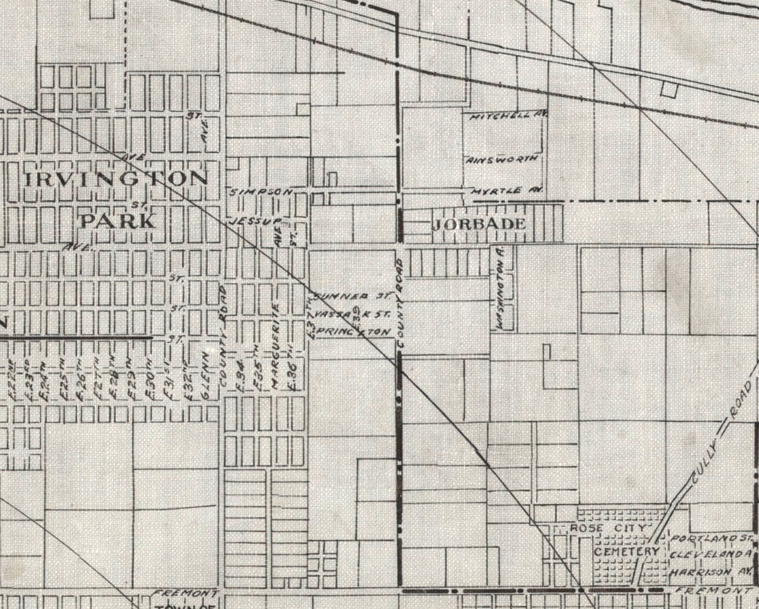
Detail from a 1908 Portland Railway, Light and Power Map showing the vicinity of 42nd and Killingsworth, in the center of the image. The Jorbade subdivision was platted at the intersection in 1908. The western “County Road” is today’s NE 33rd. The eastern “County Road” is NE 42nd. Rose City Cemetery appears in lower right (note that Cully passes through the cemetery). The cross-hatch lines indicate mile increments distant from downtown. The Irvington Park plat is part of today’s Concordia neighborhood. The Alameda Park Addition had not yet been platted and is shown as open fields.

Continuing from our first installment exploring the layers of history at NE 42nd and Killingsworth…

The early years of the 20th Century brought a sea change to the Portland area: dramatic growth in population and a spike in residential and commercial construction that followed; a steady increase in the area’s rail and river shipping and port activity; extension of an interconnected electrified streetcar system; and arrival of the automobile. The 1905 Lewis and Clark Centennial Exposition drew national and international attention to Portland, attracted business and new residents, and set Portland on a growth curve that would remake the region.

During those early years, the vicinity of NE 42nd and Killingsworth was still a rural crossroads. Killingsworth (which was gravel) didn’t go farther east: it dead-ended into NE 42nd Avenue, which was known only as “County Road” up until the late 19-teens. Maps show the area much like the 1897 USGS map until the second decade: fields all around and less than 30 buildings—many of them barns—within a one-mile radius of the intersection.

But real estate speculators and some landowners could see the writing on the wall. Streetcar lines were working their way east, and new subdivisions and commercial areas were being planned and built. By 1912, a high volume of residential construction was underway in nearby Alameda, Beaumont and Rose City, all of which had been similar open fields and dirt roads.

Open lands are platted for homes, setting the stage for the area we know today

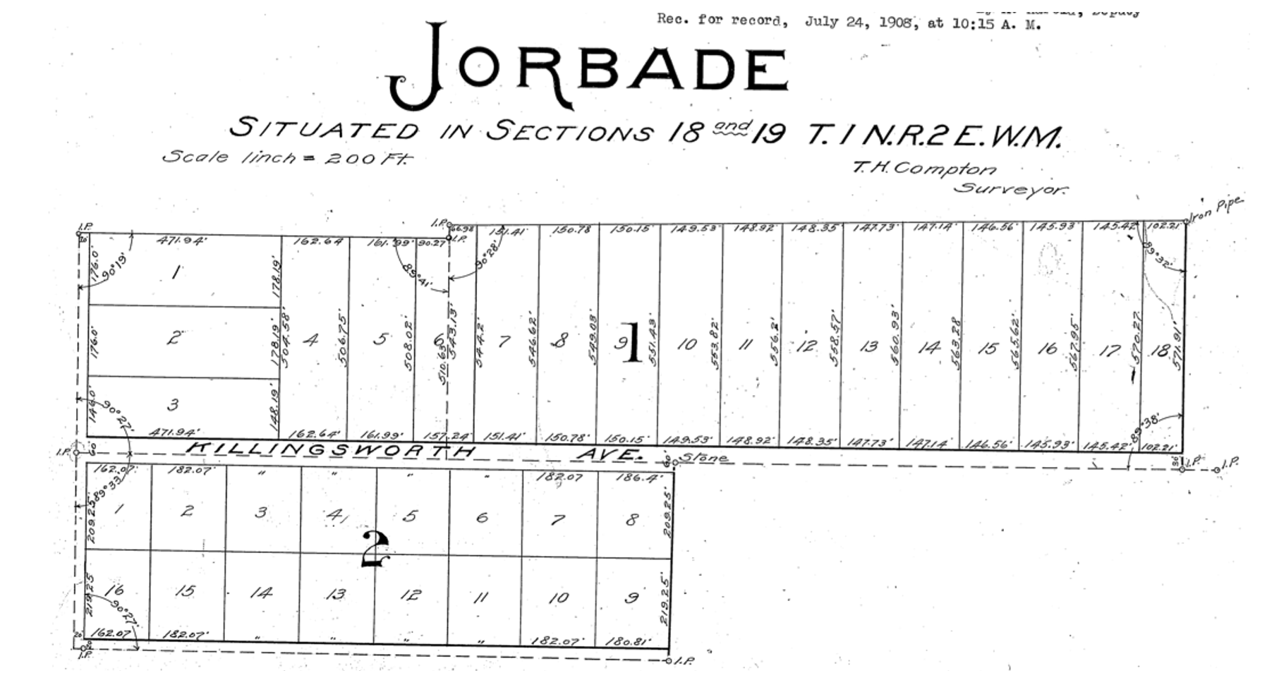
By 1909, real estate speculators Commodore Perry Jordan and Theodore August Garbade had purchased a portion of the old Isaac and MaryAnn Rennison Donation Land Claim at the intersection of today’s NE 42nd and Killingsworth. The two planned to sell residential building lots from what had been open farm land. Jordan and Garbade called their planned suburb “Jorbade,” and filed this plat with Multnomah County. The western edge of the plat is NE 42nd Avenue. Important to note that Killingsworth wouldn’t go through for at least 10 more years. These lots would be just that–vacant lots–for many more years.

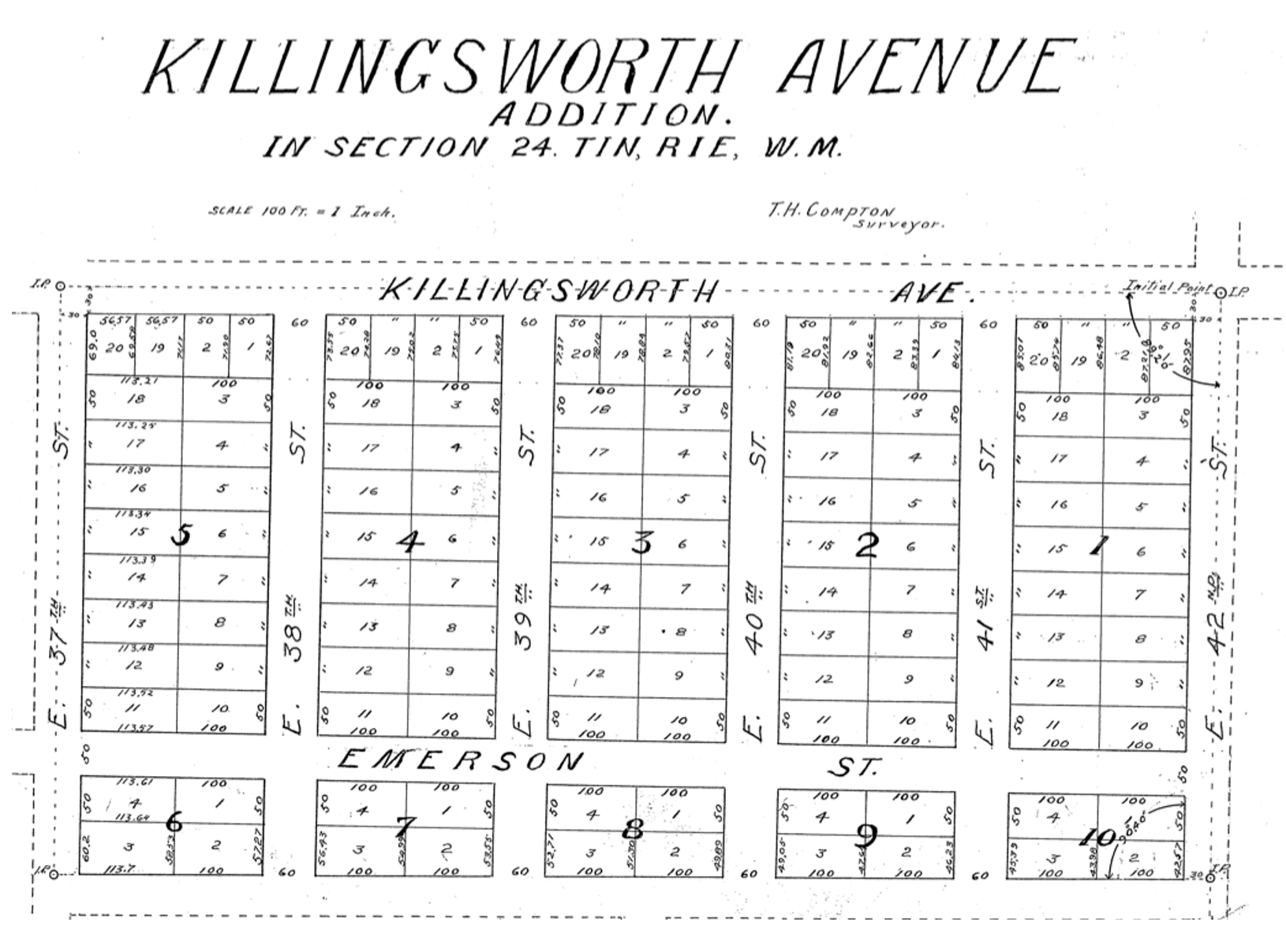
A few years later Jordan and Garbade acquired the lands on the opposite corner and were ready to convert them too from open fields to a subdivision. In 1911 they platted the Killingsworth Avenue Addition, from Killingsworth south beyond Emerson, between NE 37th and NE 42nd.

A bit farther west, local resident and real estate speculator John D. Kennedy was a few steps ahead of Jordan and Garbade. He had bought old homestead lands in 1880 believing that Portland would one day expand east; in 1890 he platted the Kennedy Addition, while this area was still part of its own town: East Portland. Here’s a detailed look at Kennedy and his adjacent nearby lands.

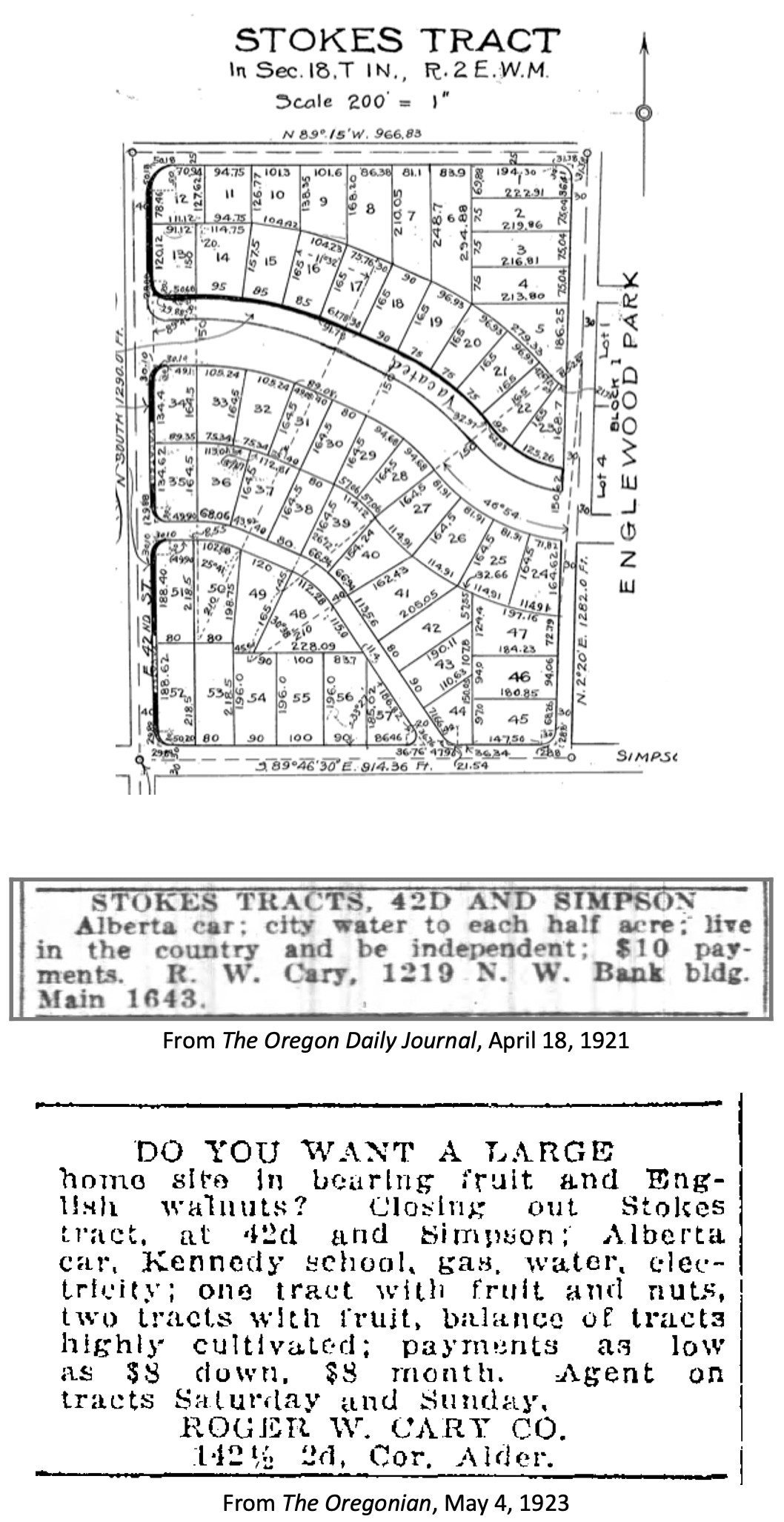
The Stokes Tract followed Jorbade and the Killingsworth Addition in 1920, north of Killingsworth and east of 42nd, establishing the graceful arc of Ainsworth and Simpson Court. This area retained a rural feel: “Live in the country and be independent” reads the advertisement.

Other subdivisions followed including tiny View Park in 1923, on the north side of Killingsworth between 36th and 40th:

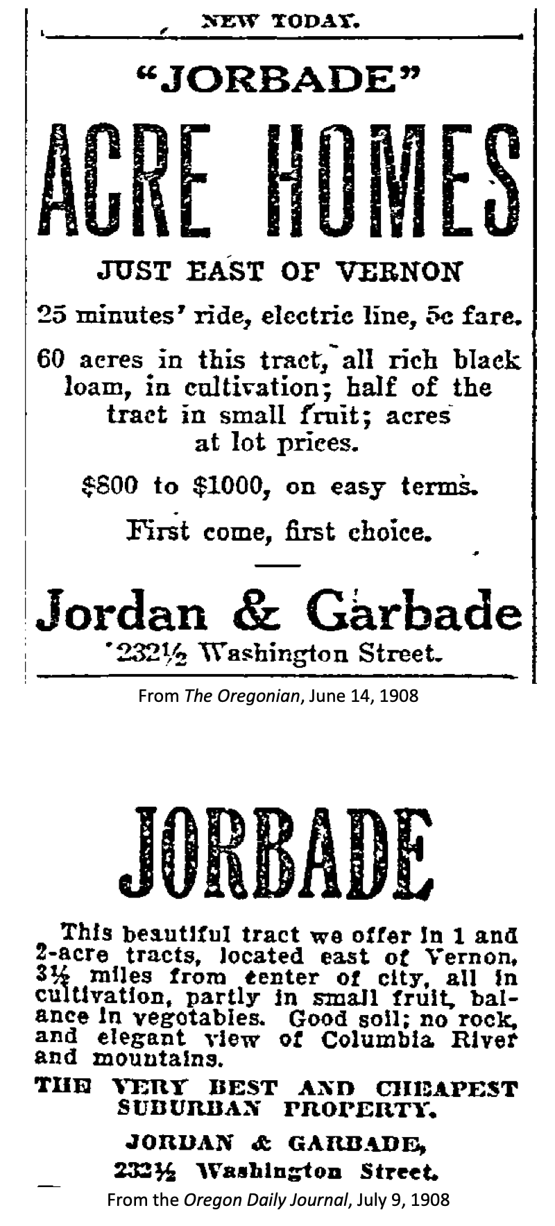
Interest in these planned subdivisions was not particularly strong until the late 1930s: their distance from downtown, their presence outside the city limits and about a mile walk from the nearest streetcar line (despite what the advertisement said about being on a 5 cent fare line); their rural nature including gravel roads and surrounding fields and orchards may have made them less attractive, even if the prices were lower. But as Portland continued to expand, and the automobile became more prevalent, would-be homeowners were ready to buy and build.

Classified advertisements for properties adjacent to the intersection report a variety of crops growing at the time: orchards of Bing, Lambert and Royal Anne cherries; English walnuts; Bartlett pears; prunes and plums; apples; rows of strawberries and raspberries.

Often referred to as “truck farms” because the produce was trucked to market (and some of it was sold out of the back of trucks at busy intersections and small markets around town), these surrounding fields produced fruit and vegetables for Portland households. One farm near the corner of what is today’s NE 41st and Holman was owned and run by a Japanese immigrant family, as were others in the area. During WWII, Japanese farming families across the Pacific Northwest were removed from their land and placed in internment camps in southeast Oregon, central California, Idaho, Utah, Wyoming and Colorado.

Portland Air Base leads to new roads and new residents

By 1935 air freight and airline passenger traffic had overwhelmed Portland’s first airport—located on Swan Island—and the city spent $300,000 to purchase a 700-acre site adjacent to the Columbia River where today’s Portland International Airport resides. With a grant from the Works Progress Administration, workers drained the former floodplain and dumped more than 4 million cubic yards of sand across the site. The airport opened in 1941. During the hundreds of generations of indigenous presence prior to European contact, these wetlands had been both seasonal home and food source.

Following declaration of war in late 1941, Army Air Base operations at the site were dramatically increased and Portland became a regional magnet, attracting tens of thousands of workers and their families to multiple war-related industries across the Portland area. An immediate demand for housing, combined with a newly-improved road network and the availability of open land in this area so close to the airbase, fueled interest.

A small expression of the interest was a long row of connected cabins dubbed the “tourist cabins” and an adjacent business called the Spur Tavern at the northeast corner of NE Holman and 42nd avenue. Built in 1942 as temporary housing for the great influx of people, the residences and tavern became a landmark of sorts. Read more about the Tourist Cabins and the Spur.

City buys old farms to create Fernhill Park

After voters approved a property tax levy in 1938 to create more parks and playgrounds for a growing Portland, the city set out on a 10-year process of buying the hills and gullies northwest of 42nd and Killingsworth, starting out in 1940 with a 10-acre parcel owned by the Jackson family right in the middle of it all.

Prior to acquisition, several dirt roads criss-crossed the north side of the area, one even ran right up the bottom of the gully at the heart of today’s off-leash area in the northeast corner of the park, pausing at a wide spot that served as a dump and debris field where car bodies and all manner of junk were strewn.

It wasn’t an official dump, but more like a secluded out-of-the-way place where residents from the surrounding area dumped unwanted items. In the late 1930s and early 1940s, when the NE 42nd Avenue connection to Columbia Boulevard was built, some of the dirt fill needed to make the grade change for the overpass was dug out from and supplied by the gully on the east side of the park along today’s NE 41st Avenue.

As the park took shape through the late 1940s and early 1950s, some locals referred to it as Ainsworth Park, a name that appears frequently in real estate advertising of that era. By the early 1950s, most of the open land to the north of the park had been converted to subdivision (the Vanlaeken and Leitritz plats). NE Highland Street was put through the middle of working farmland as the area was transformed into suburbia. By June of 1951 when most of the park buying was done, the city had invested $60,479 total for all of the parcels and had acquired 25.95 acres. Read more about the origin of Fernhill Park.

Aerial photographs = time travel

As a reward for reading this far, and as preface for the next installment, here’s a series of aerial photos that allow us to witness change. Each of these is fascinating, so click in for a detailed view. Observations follow each image. Aerial photos courtesy of the University of Oregon Map and Aerial Photography Library.

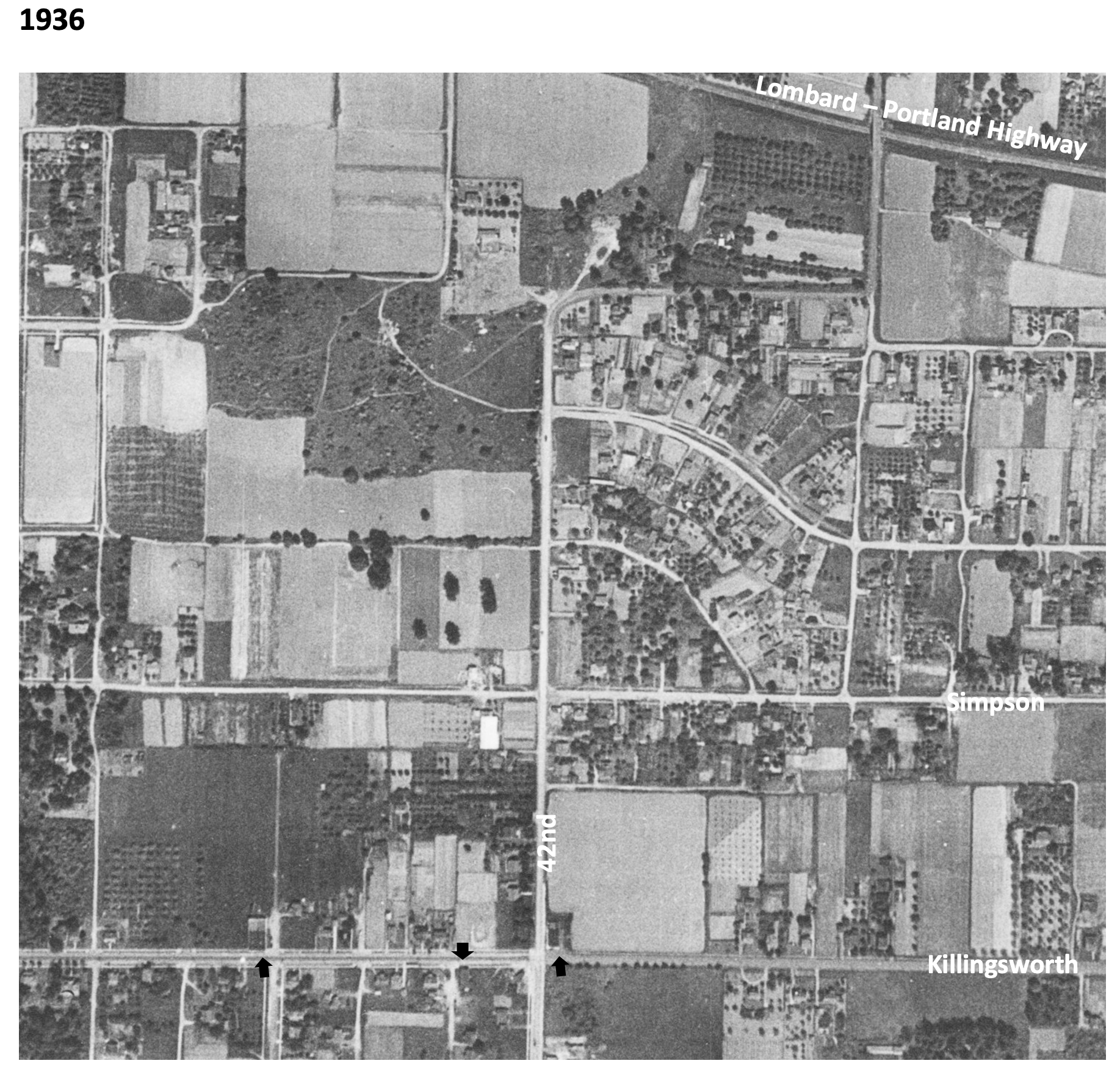
In 1936, the unplowed lowlands of today’s Fernhill Park show up just left of center, and the arc of Simpson Court and NE Ainsworth feed into NE 42nd. No viaduct yet over Portland Highway. The arrows indicate locations of three small mom-and-pop groceries. Note that Simpson goes through east-west, across the middle of today’s Fernhill Park.

In 1939, more houses are showing up, and orchards in the center of the photo are maturing.

In 1948, the 42nd Avenue viaduct is in place (not pictured) connecting NE 42nd to the new Portland Airport. Houses continue to replace open fields. The greenhouses at Knapps Nursery appear west of NE 42nd at Simpson. Orchards near NE 37th and Killingsworth are replaced by homes.

In 1951, a trailer park appears at the NE corner of 42nd and Killingsworth in what were once open fields. Significant new home construction is evident north of Killingsworth and west of 42nd. The flat playing field at the south end of Fernhill Park begins to emerge from the former agricultural fields north of Simpson, and west of 42nd. Construction is underway on the new St. Charles Church and school.

In 1961, the trailer park is replaced by a large Safeway store and parking lot at the corner of 42nd and Killingsworth, which opened in 1957. A baseball diamond is clearly visible in the new Fernhill Park. Orchards and open agricultural fields are gone. Simpson still goes through west of Killingsworth. South of Simpson in this area, 26 homes, three duplexes, a PGE power substation, and Knapp’s greenhouses and nursery are soon to be demolished or moved–over the strenuous objection of neighbors–to make way for John Adams High School.

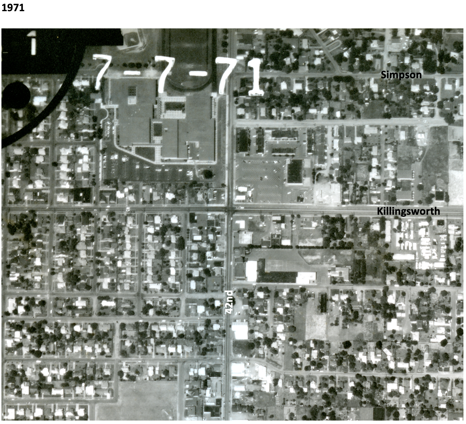
In 1971, John Adams High School is in place, replacing a portion of the open areas of Fernhill Park and most of the homes between Killingsworth and Simpson west of 42nd. Simpson no longer goes through west of 42nd. Acres of parking are available west of the Safeway store at 42nd and Killingsworth.

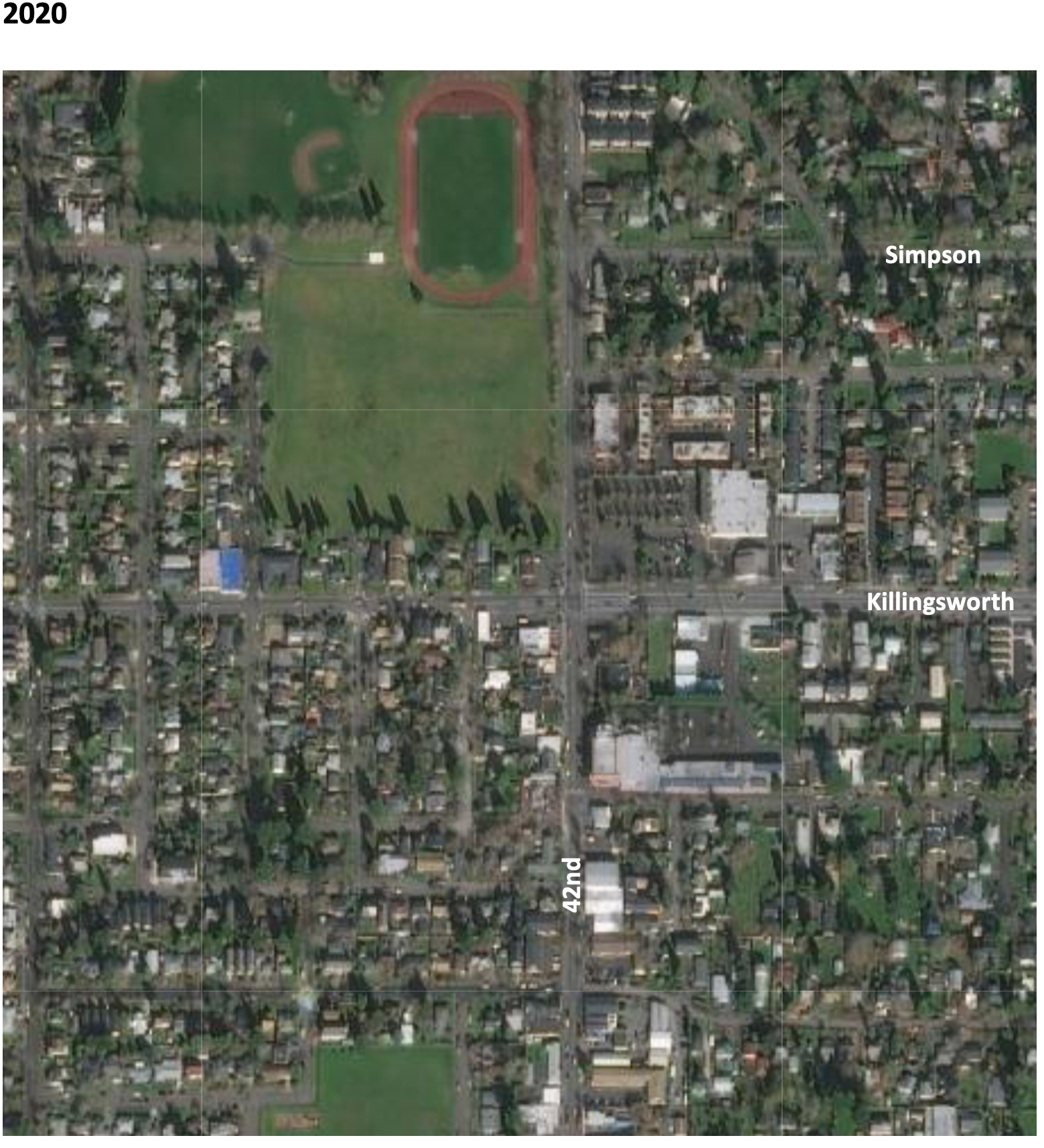
By 2020, John Adams High School (later known as Whitaker Middle School) was demolished in 2006, but the track remains. Neighborhood street tree canopies are filling out. Safeway is closed and the buildings at the northeast corner of 42nd and Killingsworth are now gone.

Next: The changing retail face of the intersection: from Cliff and Mary’s to Safeway and beyond

Time travel deep dive at NE 42nd and Killingsworth

The intersection of NE 42nd and Killingsworth can feel like it exists on the way to somewhere else. But this crossroads has its own rich history that runs deep.

NE 42nd and Killingsworth, looking northeast. Fall 2023, Google streetview.

It’s worth slowing down time a bit to be able to see and explore the chapters here, which run back through commercial retail and early neighborhood development to wide open fields of berries and orchards, further back through the homestead era and even down slope toward the Columbia River and the slough wetlands that have been known and inhabited by Chinookan people since time immemorial.

This is the first of a three-part exploration to spark your imagination about the layers of history here. In this first installment, we’ll overview the arc of the story. In the second installment, we’ll take an illustrated deep dive into the subdivision years between 1900-1940 when everything was changing for the neighborhoods around the crossroads. Our last installment will explore the changing look of the intersection itself from the 1950s-1980s: gas stations and mom-and-pop groceries, greenhouses, a Safeway store, a trailer park, Adams High School and more.

Today, both NE Killingsworth Street and NE 42nd Avenue are well-used surface streets in the Northeast quadrant of Portland. The traffic-controlled intersection where they cross—poised at the northern edge of the 42nd Avenue / western Cully neighborhood commercial area four miles from the downtown core of the city center—features restaurants, bus stops, a convenience store, direct access to a city park and a brand-new workforce training center operated by Portland Community College. In fall 2025, Home Forward will open 84 units of affordable housing here. This is a busy place.

Early slopes above the Columbia Slough

For millennia the uplands south of the Columbia Slough and Columbia River were covered by a mixed forest of Douglas-fir, hemlock, cedar, alder and maple. Periodic fires, windstorms and outbreaks of insects and disease created openings in the forested canopy. The upland plateau that would eventually become the vicinity of today’s NE 42nd and Killingsworth sloped gently down to meet a vast flood plain, which followed an east-west line at the foot of the slope traced by today’s NE Columbia Boulevard.

Situated between the bottom of the slope and the main channel of the Columbia River just to the north was an interconnected flood plain mosaic of wetlands, ponds, marshes and off-channel waterways. Chinookan seasonal gathering places and dwelling places thrived here for thousands of years.

“Interior of Ceremonial Lodge, Columbia River,” an 1846 oil painting by Paul Keane, who traveled among the Chinook villages of the lower Columbia River.

Explorers, trappers and traders passed by on the Columbia River in the early 1800s intersecting the lives of indigenous people who had known this area since time immemorial. Early white traders introduced successive epidemics of disease, disruption and depredation, and by the 1830s the Chinookan people’s settlements in this area and their ways of life had been dramatically changed. By the late 1840s, Oregon Trail settlers arrived in the area; this immediate vicinity was homesteaded by several families practicing a mix of agriculture, trade and subsistence. Forests were removed, roads were constructed, and homes and barns built.

Surveys gridded the land

With the opening of the Oregon Trail in the mid 1840s and arrival of an increasing number of outsiders seeking land for farms and homesteads, the U.S. Government established a systematic process to map and identify lands that had been mostly cleared of indigenous people that could be granted to newcomers. Survey crews got to work here in the Portland area in 1851 establishing the Willamette Meridian, a systematic grid of townships, ranges and sections across the territory and the Western U.S. that promoted the availability of lands.

Today’s intersection of NE 42nd and Killingsworth exists at the corner of four sections of the Willamette Meridian: Township 1 North Range 1 East, sections 13 and 24 to the west; Township 1 North, Range 2 East, sections 18 and 19 to the east. Here is a compilation of those two original survey maps (click in for a closer look, they are fascinating). Observations below.

On the left is Township 1 North, Range 1 East. Notable are the early grid of a young Portland in the lower left; the location of past forest fires; the proximity of early trails and the complex waterways that make up the Columbia Bayou to the north. The blue arrow indicates the approximate location of today’s NE 42nd and Killingsworth. On the right is Township 1 North, Range 2 East. Notable here are the “wet prairie” description of the Columbia Slough bottomlands in the vicinity of today’s Portland International Airport; the road running northeast, predecessor of today’s Cully Boulevard; the surveyor’s descriptors—land gently rolling, soil 2nd rate, gravelly. Timber, Fir, Hemlock, Maple—describe vegetation in the area at the time; Rocky Butte shows up as the raised topography in the center of the map.

In October 1851, surveyor Butler Ives and his crew walked all through this area in order to draw these maps, and characterized what they saw like this:

Upland situated in the middle portion of the township is gently rolling and is elevated from 50 to 100 feet above the adjoining bottoms. The soil of the above is nearly uniform and good second rate clay loam and some gravelly in the northeast portion south of the Columbia bottoms.

The bottom lands both of the Willamette and Columbia, is from 5 to 15 feet above low water, the most elevated being along the banks of the rivers and bayous; they are subject to an annual inundation lasting from 1 to 2 months in the summer season, leaving only a few of the higher places dry. They are mostly open grassland. Soil rich alluvial and badly cut up with bayous, stagnant ponds and lakes which render nearly one half of them unfit for a cultivation.

The timber on most of the uplands is heavy and varies from 1 to 2 and in some instances to 250 feet in height. It is principally fir with a little maple, cedar, hemlock and dogwood interspersed.

The undergrowth is vinemaple, maple, brush and is usually thick; there is considerable dead and fallen timber caused by fire which has run through most of this Township.

In the bottoms is ash, willow balm, Gilead, crabapple with oak, and is found skirting the banks of the rivers and bayous. The undergrowth is in thick mixture patches of hardwoods, rose bushes gooseberry bushes and vines. The Columbia bayou is deep in most places and will admit boats drawing several feet of water. The other bayous are generally shallow.

As more people arrived, the surrounding lands were further divided, sold and developed. Wetlands to the north were drained for agriculture. More roads were built and active steamboat commerce developed on the nearby Columbia River. In 1882, a short stretch of dirt road in the growing nearby town of Albina was dedicated as Killingsworth Street, named for prominent real estate developer William Killingsworth. One year later—1883—the Oregon Railway and Navigation Company opened an east-west rail line passing nearby to the south that connected Portland with a growing network of regional and national railways.

A patchwork emerges

Our crossroads was well outside the eastern boundary of East Portland, which in 1891 consolidated with the towns of Albina and Portland (on the west side of the river) to form the single City of Portland. A rough north-south gravel trace known as the County Road (today’s NE 42nd Avenue) was carved out connecting the east-west predecessor of today’s Fremont Street with the east-west road along the Columbia Slough (today’s Columbia Boulevard). Growing population and commerce continued to boost Portland’s expansion. By the turn of the century, lands that 50 years earlier had been taken from indigenous people and deeded by the federal government to a handful of incoming families were being subdivided and sold into hundreds of parcels.

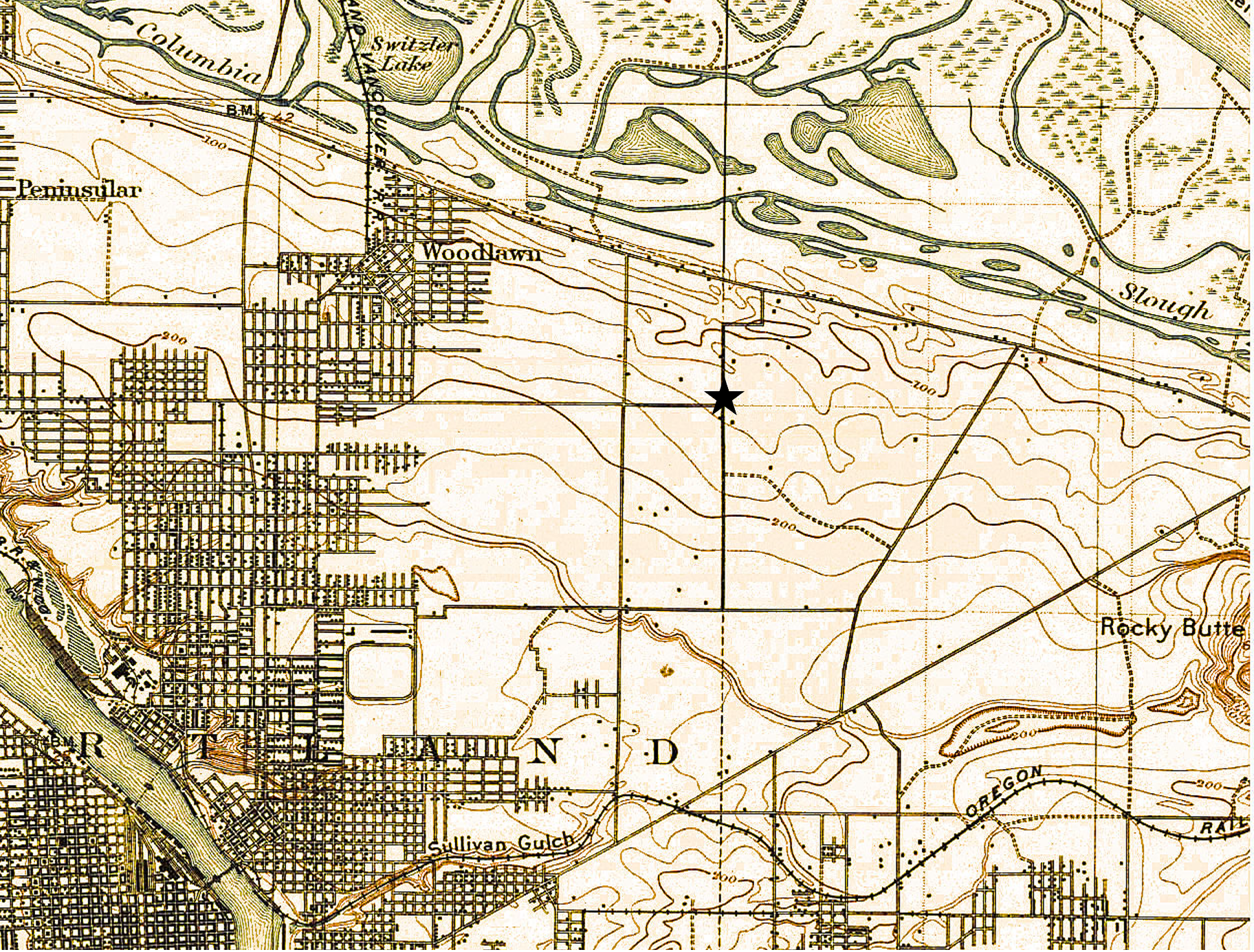
A patchwork of agriculture and development dotted the surrounding landscape with small farmsteads of orchards, berries and vegetables interspersed with homesites. Below is a detail from a USGS 1897 map of the area (star shows location of NE 42nd and Killingsworth). Notable here is that Killingsworth does not go farther east; development does not proceed much farther east than NE 7th; scattered farmsteads occupy the area of today’s neighborhoods; the Irvington race course at NE 7th and Fremont shows up in lower left.

Because of the area’s distance from the downtown core, its location beyond easy access to the streetcar system which promoted development, and its agricultural productivity, the crossroads remained largely rural until the opening of Portland Airbase in 1941, which was then a brand-new facility built on the reclaimed floodplain wetlands just south of the Columbia River.

Post-war boom ignites interest

The wartime expansion of manufacturing, residential growth and military operations drew new attention to the area, leading to transportation improvements and northern extension of NE 42nd Avenue with a viaduct over the Columbia River Highway, making it a major throughway from the eastside to the airbase. Residential and commercial development followed. Portland’s post-war housing boom in the 1950s led to further development, including more subdivisions, construction of a busy trailer park at the northeast corner of the intersection, and city acquisition of remaining nearby farm lands into what would become today’s Fernhill Park just to the northwest.

By the 1960s the area had been annexed into Portland proper. A commercial hub had developed at NE 42nd and Killingsworth including large and small grocery stores, service stations, bars, restaurants and light manufacturing. In the mid-1960s, the Portland School Board condemned a portion of the surrounding area to build John Adams High School, in direct opposition to residents’ wishes, razing homes and businesses. The school complex was later transitioned into Whitaker Middle School, and eventually torn down in 2006 due to changing student demographic needs and concerns about radon gas and the presence of unhealthy black mold found throughout the building.

Next: From farm fields to city lots – plats and development arrive

Time Travel at NE 30th and Killingsworth

Photographs taken 91 years apart remind us about change and constancy at a busy corner in the neighborhood. Check it out:

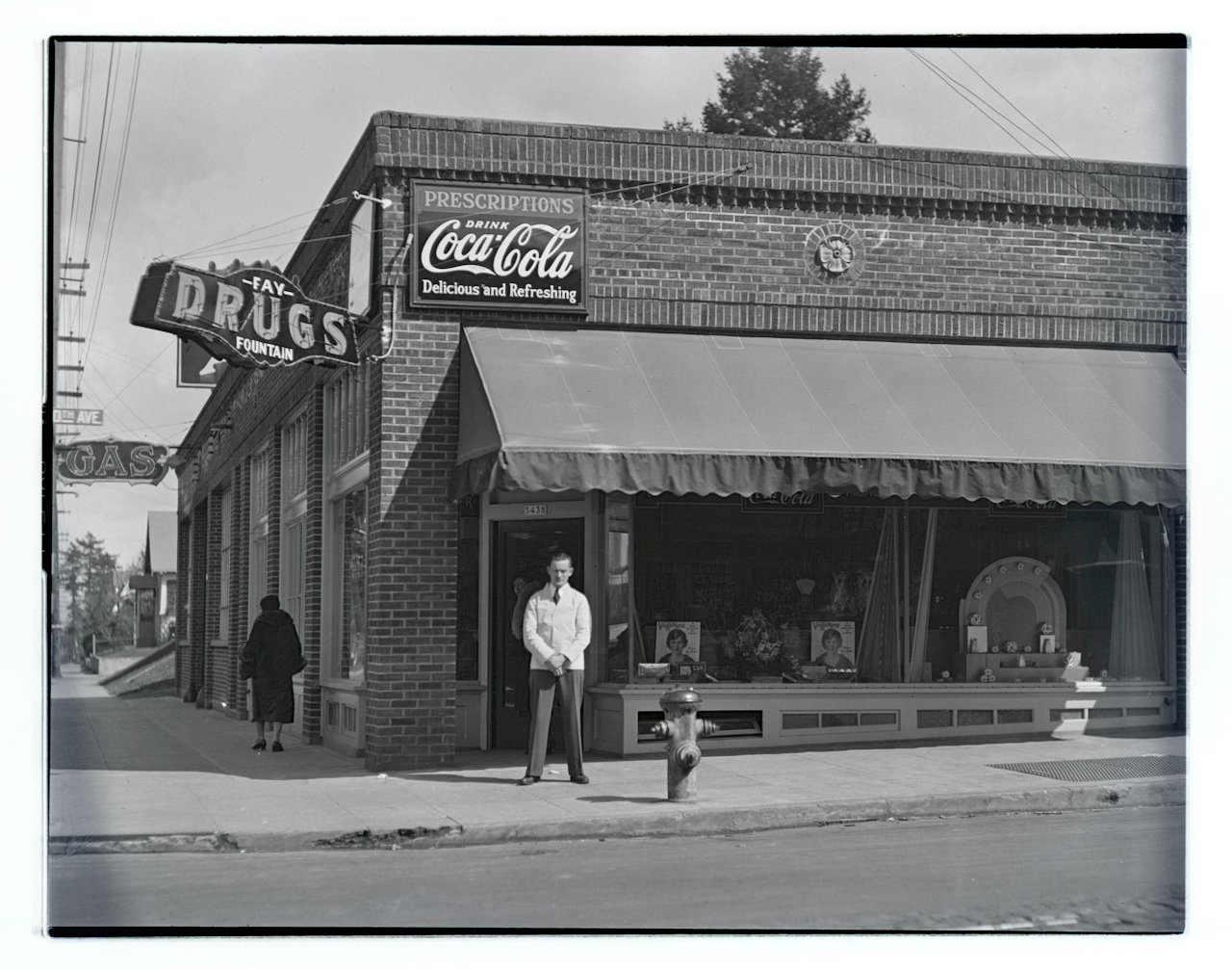
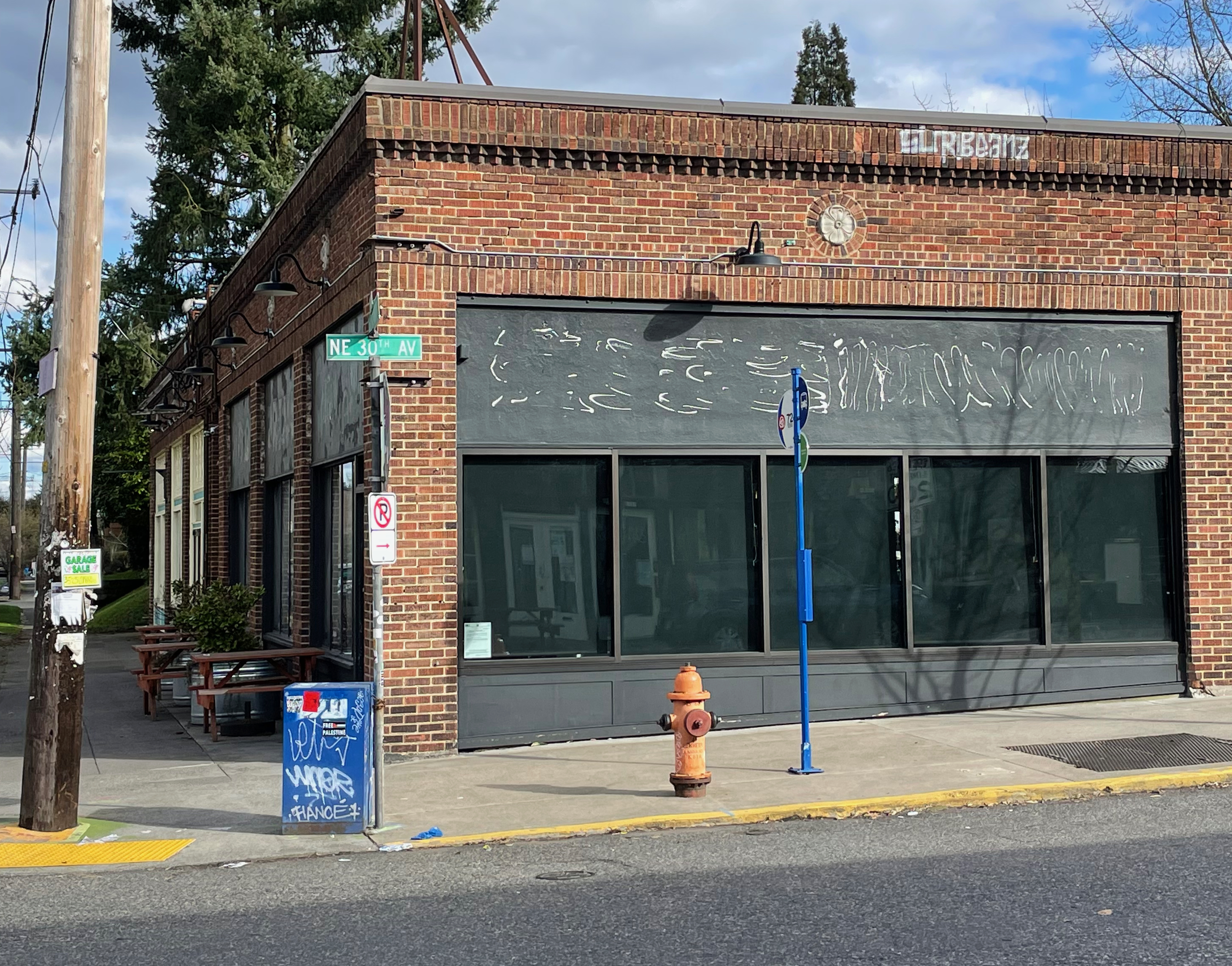
Top: View looking east, Joseph Laurence Fay (1906-1951) poses in front of his business at the southeast corner of NE 30th and Killingsworth in 1933. Photo from the Oregon Journal Negative Collection at the Oregon Historical Society, Lot 1368; Box 372; 372A1209. Bottom: The same view in March 2024, when this storefront was in transition.

Built in 1927, this commercial block of storefronts has housed everything from Fay’s Drugs and Fountain–pictured here in a photo from the Oregon Journal in 1933–to the RCA Service Company, to the Portland Venetian Blind Company. In the 1950s it was home to neighborhood dentist Dr. Tinkle. More recently, it’s been a coffee shop and café, a bar and a game arcade.

This busy corner, known as Foxchase, is well worth exploring: several good restaurants, a great cocktail lounge, a new bakery and more. And the story of Foxchase is pretty fascinating too, be sure to check it out.

New Builder Biographies | Check for your address

We’ve added two more builder biographies to our growing collection of Portland area home builders from the early 20th Century: A.C. Galbraith, a prolific builder of small bungalows, based in St. Johns; and W.H Dunn, a retired Canadian wheat-grower-turned-builder who started his building career late and operated in Irvington, Alameda and Laurelhurst.

Both were in early on the building boom of the 1920s. Both worked mostly from standard plan sets. Both built most of their houses on speculation, without a contract or particular client in mind on faith the house would sell. And both were crushed by the Great Depression, like so many builders.

Their trials and accomplishments add to our understanding of the times.

More builder profiles to follow (we love doing these) and appreciate the suggestions from readers. If you haven’t read the bio of Harry Phillips and the recent comments from his great-great granddaughter who found our profile of Harry, do check it out.

Too icy: January 17th program rescheduled to January 31st

Our recent foray into historic snow and ice storms seems to have been eclipsed by the current conditions!

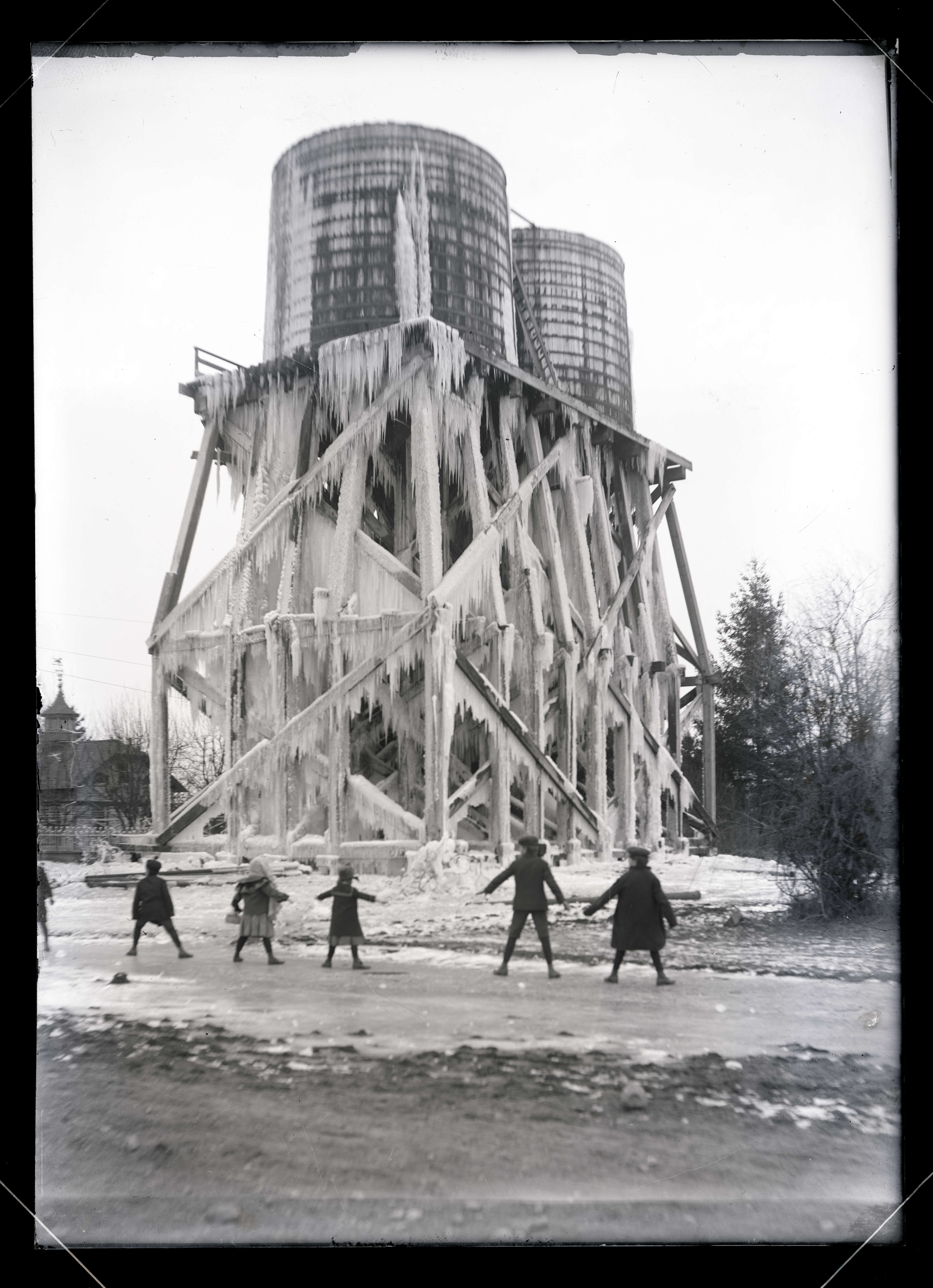
Sellwood Water Tower during the 1916 silver thaw event. Courtesy of Oregon Historical Society, image OrgLot151_PGE139-4

Due to the current ice storm, this evening’s scheduled program on the Oregon Home Builders has been rescheduled to the same time and place on Wednesday evening, January 31st. The free program is sponsored by the Alameda Neighborhood Association and RSVPs are required.

To reserve your spot, please e-mail the Alameda Neighborhood Association at alamedanewsletter@gmail.com. Doors open at 7:00 and the association will have light refreshments on hand.

Stay safe out there.

History of Snow, reprised

In the midst of the current blizzard, we’ve been reminiscing about past winters and pieces we’ve written here over the last 17 years (can it really be 17 years?) that explore the timelessness of snow.

Deadman’s Hill, February 2021

There’s the piece that explores the story behind Deadman’s Hill, which will once again be alive with sledders reenacting more than a century of tradition.

There’s our Billy Collins poem-inspired History of Snow piece that looks back at a century of Portland winters and a few photos from the snowy neighborhood in 1936.

There’s the Oregon Historical Society treasure trove of ice storm photos from 1916, and an analysis of ice storms before 1916.

We’re in it now. But the daffodils are patiently waiting.

Join for an evening of local history – January 17, 2024

In collaboration with the Alameda Neighborhood Association, I’ll be presenting a program on the work of the Oregon Home Builders Co., Wednesday, January 17, 2024 from 7:30-9:00 p.m. at the Fremont United Methodist Church (2620 NE Fremont), and you’re invited (RSVPs required, see below).

The Oregon Home Builders company set out in 1912 to pursue its vision of homebuilding market domination by selling stock to investors and by building memorable homes for its customers. During five years between 1912-1917, the company built more than 125 homes, including many in Alameda, several of which are listed today in the National Register of Historic Places.

The company was unique among homebuilders of the era because it catered to both ends of the economic spectrum: large, charismatic custom-designed homes for the wealthy, and simple, affordable thoughtfully-designed bungalows for those just entering the housing market. Join me for an inside look at the intriguing rise and fall of the company and the legacy of its homes today.

To reserve your spot for the January 17, 2024 program, please e-mail the Alameda Neighborhood Association at alamedanewsletter@gmail.com. Reservation deadline is January 10th. Doors open at 7:00 and the association will have light refreshments on hand.

The Alameda Neighborhood Association is a neighbor-led board that advocates for smart policies, takes action on neighbors’ concerns, facilitates communication about neighborhood issues, hosts events to bring residents together and publishes the quarterly newsletter AlamedaPDX.

New Years Eve 1923

In the spirit of all the year-end reviews and lists floating around at the bottom of the year, we thought it might be interesting to look back to 1923 for a little perspective.

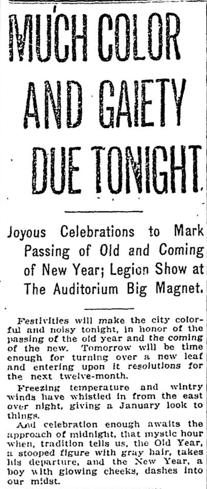
100 years ago tonight, Portland was in the jaws of a cold snap with temperatures in the teens accompanied by a dusting of snow. The front page of our evening paper—the Oregon Journal—previewed celebrations on tap in local theaters, cabarets and dance halls and included stories about plans for bridges over the Willamette River at Ross Island and on Burnside.

From the Oregon Journal, December 31, 1923

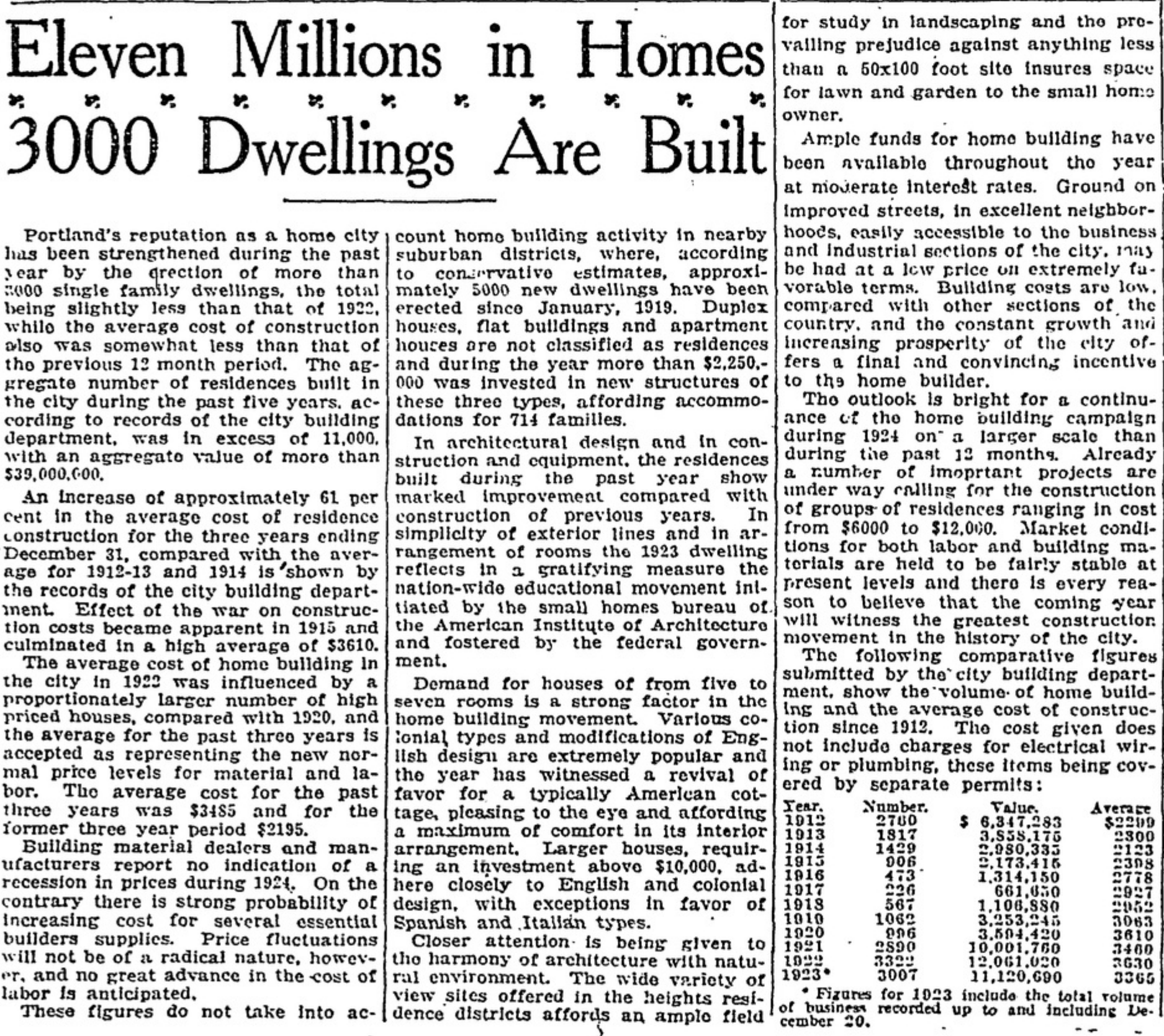
Elsewhere in the newspaper 100 years ago tonight—and on our favorite topic of historic homebuilding—is a review of the very busy building business in Portland for 1923. 3,000 single family dwellings built at a value of $11 million. Have a look at the numbers that go back to 1912, a barometer of economic conditions in Portland that track with the trends we’ve found in our building permit review. Interesting discussion of architectural styles too:

From the Oregon Journal, December 31, 1923

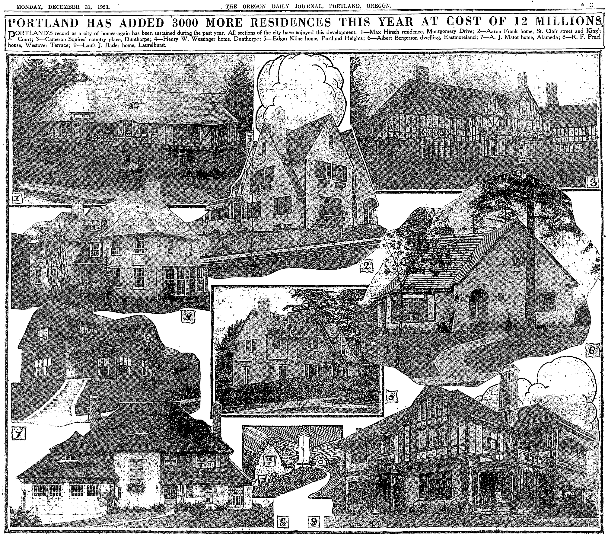
Appearing with this story is a homebuilder’s greatest hits photo montage from 1923. Click in for a closer look:

Happy New Year from Alameda History!

In praise of Swedish homebuilders

Two new profiles to add to The Builders collection, both Swedish immigrants, one who had a brother in the business that we have already profiled, though they chose to spell their last names differently.

Stockholm Harbor, summer 2023

Herman Nelson, who immigrated through Canada in his early 20s a few years ahead of his younger brother builder Emil Nilson; and August Malmquist, or as he is more frequently referred to on building permits as A.C. Malmquist. Learning more about the third Nelson/Nilson brother, Oscar, is still on our to-do list.

Included in all of these profiles is a list of homes built by these builders, so by all means check to see if your address is here.

These three Swedish carpenters built hundreds of houses in Northeast Portland neighborhoods, and operated mostly as Mom-and-Pop businesses, with spouses’ names occasionally showing up on real estate transactions. Their business was building houses, but they were family people too, and were active members in the Swedish community in Oregon.

We are reminded about the contributions made by so many immigrants to the shaping of these neighborhoods, and about the racial restrictions and systems that have kept others away.

Who was the George in George Place?

Like a mosaic of fine old tiles, hundreds of subdivision plats rest atop Portland’s neighborhood landscape, creating a base-layer of orderly streets and lots beneath the places we know today. Drawn up over the last 140 years by different developers, each plat has a name: some are catchy, some are descriptive, a few remain in common use to describe the places we know. Most have been lost to time, like George Place.

We’ve written about most of the underlying Alameda plats here and for a series of recent stories in the Alameda Newsletter: Gleneyrie, Olmsted Park, Homedale, the Pearson Addition, Waynewood (which was remade from the labyrinth created by six of the original plats), not to mention the nearby Kennedy Addition, the distinction between plats and neighborhood boundaries, and many other plats on both sides of the Willamette. There’s even a plats category here on the blog if you are inclined to a deeper dive.

In this parade of plats, we should make sure one of the smallest ones doesn’t get away: George Place, a tidy square of 40 lots where grid meets slope at the far southwest edge of the Alameda Plateau. Take a look:

Namesakes Judge Melvin Clark George and Mary Eckler George traversed the Oregon Trail with their families as children and grew up on homesteads in the upper Willamette Valley. They married in 1873 and Melvin was soon elected to the Oregon State Senate (1876-1880), and then to Congress in 1881, where he served two terms before returning to Oregon to teach medical law at Willamette University (1885-1889). He served as Multnomah County Circuit Judge (1897-1907) and retired from the bench at age 58 to become director of public schools in Portland.

Melvin George, circa 1900

Sometime around the turn of the 20th Century, seeing development potential on the horizon (literally), the Georges purchased six acres atop the ridge. They filed the George Place plat with the Multnomah County Surveyor on April 25, 1911, two years after the Alameda Land Company platted the Alameda Park Addition which anchored their eastern flank.

At the time, the Alameda Land Company was blitzing The Oregonian and the Oregon Journal with advertisements stirring excitement for the much larger Alameda Park Addition. Agreements were evidently made and Alameda Land Company took over marketing the property, dedicating one full advertising panel to the topic in June 1910.

From The Oregonian, June 4, 1910

Of course in 1910, all of these places were still purely imaginary: the plats may have been filed or on the drawing board, but streets were just being carved out of the gravel, trees felled, stumps removed. In 1910, it was still a giant brush patch, with orchards and dairies down on the flats below.

Lot sales and homebuilding were slow to catch on in George Place during these first years. Streets and infrastructure were in place by the mid-teens, but Portland’s economy began to cool in the run up to World War I. A few lots did sell, but the George Place six acres remained mostly unbuilt until the early 1920s, when a new real estate and homebuilding company known as the Hiller Brothers Company bought the lots and started building into a fast improving real estate market. By the way, this is one of the things we love about paying enough attention to a particular place: pretty soon everything you bump into starts to connect (see our profile of Hiller Brothers on The Builders page).

From The Oregonian, March 28, 1926. Not sure where the reporter got 80 lots, you can count the 40 lots in four blocks on the plat above.

In 1926, the streets were still gravel, but three houses were under construction including the one with the best view, for company owners James and Sarah Hiller at 2024 NE Alameda Drive. Hiller Brothers built many of the homes here, using plans provided by architect Hubert A. Williams. English cottage style was clearly the most popular. The Great Depression paused homebuilding activity leaving multiple vacant lots in George Place that finally filled in during the 1940s and early 1950s.

As for the Georges, they raised their family in a comfortable house up the hill on Market Street in southwest Portland’s Goose Hollow, with no evidence in newspaper coverage they ever lived on or paid much attention to George Place on Alameda Ridge. Melvin died at age 83 on February 22, 1933. Mary lived on to age 91 and died on September 24, 1942. They are buried together in Lone Fir Cemetery.