Street scenes illustrate change at 42nd & Killingsworth

Third in a three-part series

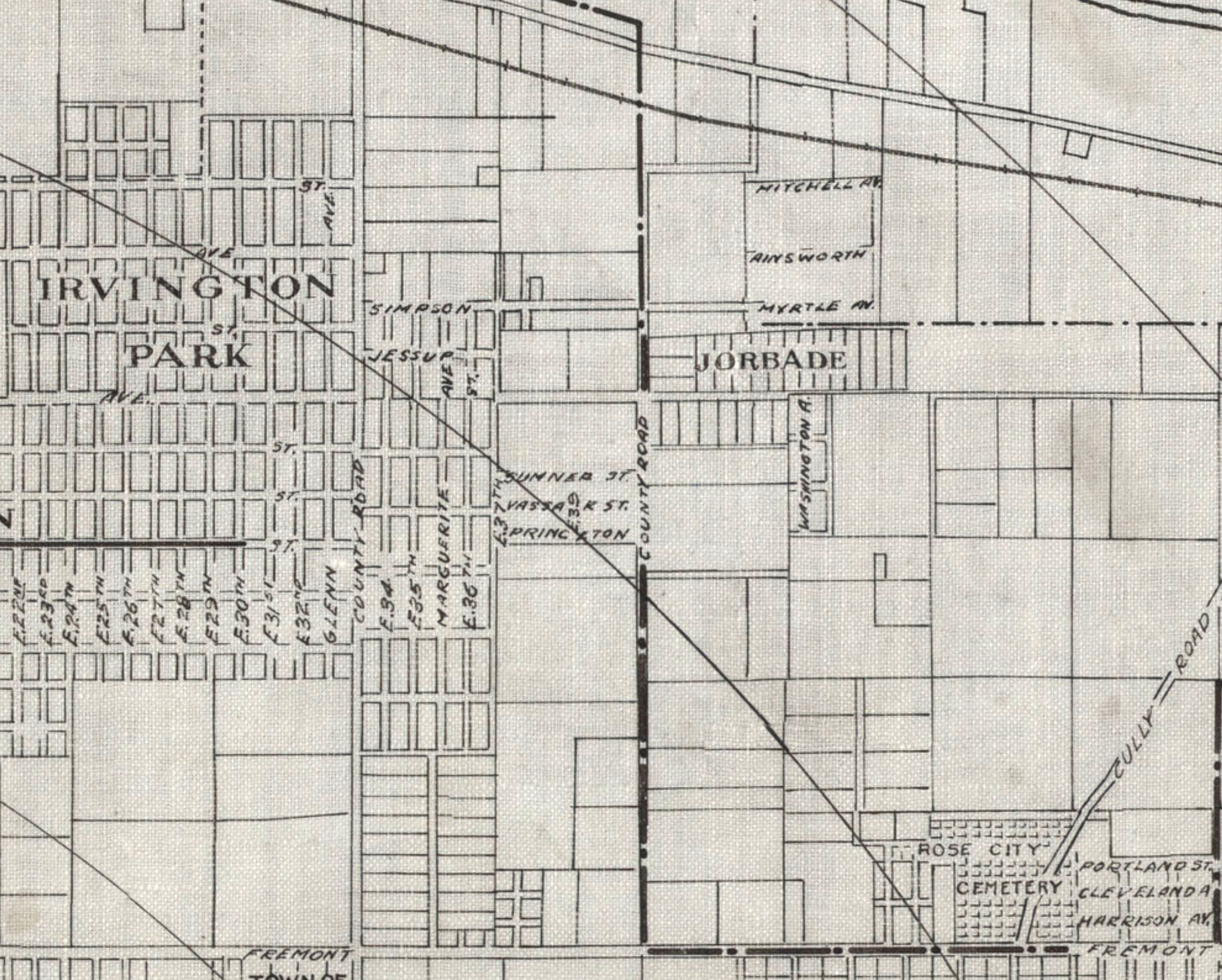
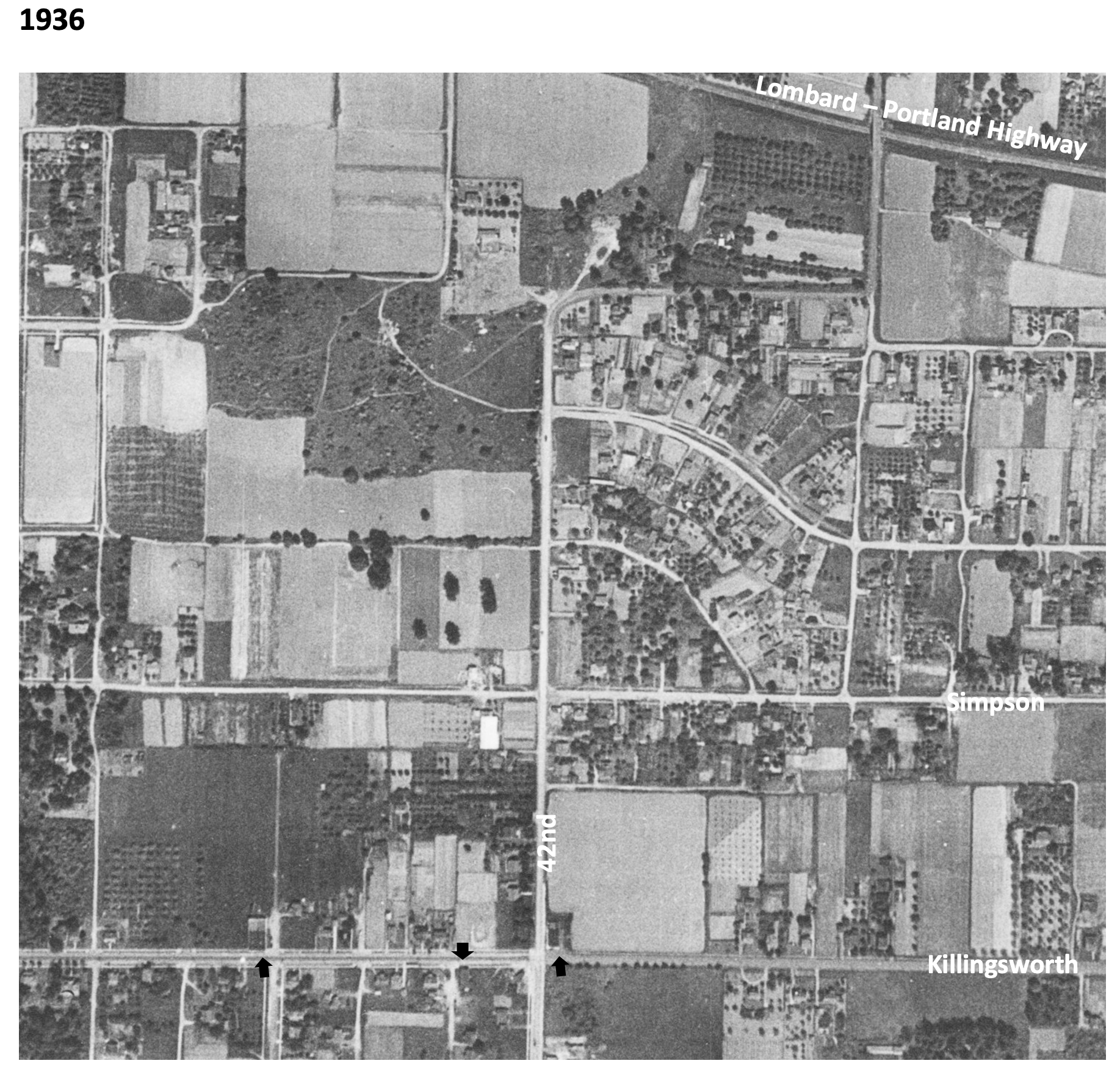
As Portland slowly rebounded from the Great Depression of the early 1930s and interest rekindled in Portland residential real estate, the stage was set for a new era at NE 42nd and Killingsworth. Open lands were available for development, subdivisions were platted with buildable lots ready to go, and new infrastructure was on the way in the form of paved roads and big plans for the new Portland Airport. A small wood-frame general store had been built in the late 1920s at what was then the quiet rural crossroads, and other nearby mom-and-pop stores were opening to meet the needs of surrounding residents.

By 1951, the corner was home to multiple gas stations, a barber shop, a cleaners, an ice cream shop and a café. The small wood frame building on the northeast corner had become the Publix Market, operated by Cliff and Mary Tadakuma. Here’s a look:

1951 Looking Northwest

Looking to the northwest at the intersection of NE 42nd and Killingsworth about 1951. The Publix Market is at the northeast corner, on the right. The Lyle Sumner service station is on the Northwest corner. Note that the intersection is not signaled. Photo courtesy of Joyce Tadakuma Gee.

Before the war, Portland had a thriving population of immigrant and first-generation Japanese families who were integrated into all aspects of civic life. In early 1942, following the attack on Pearl Harbor and declaration of war, Japanese Americans were forcibly removed from most West Coast cities and relocated to internment camps in remote inland areas of the American West. The federal policy fractured families physically and emotionally, and resulted in significant economic losses for Japanese-Americans who owned businesses and property.

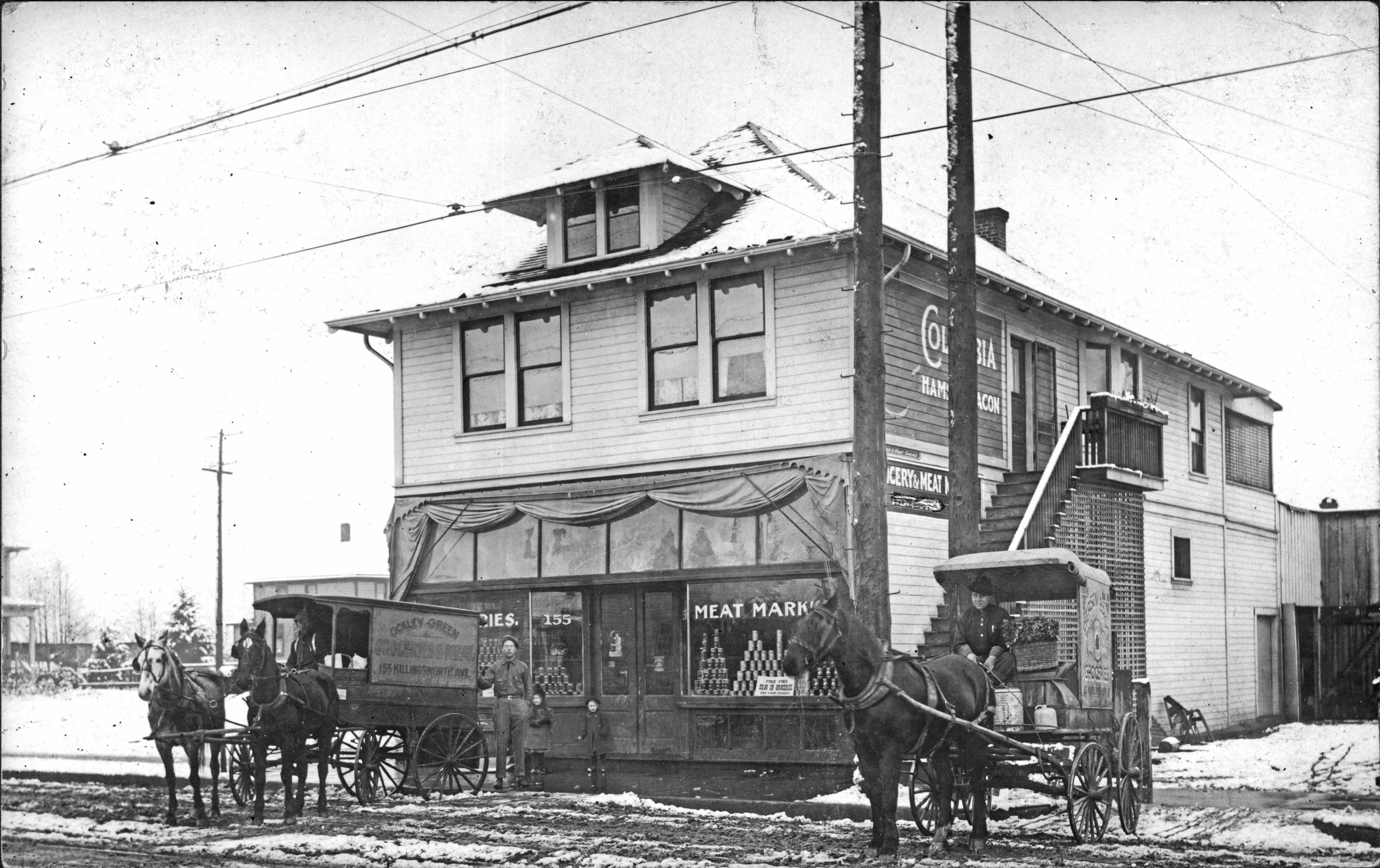
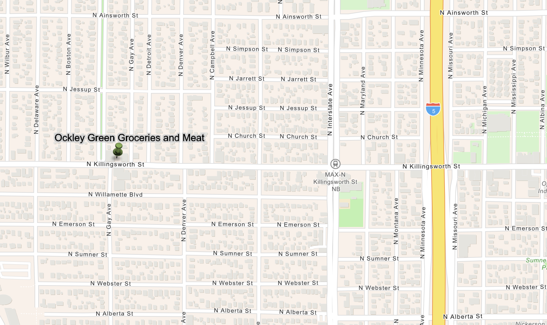
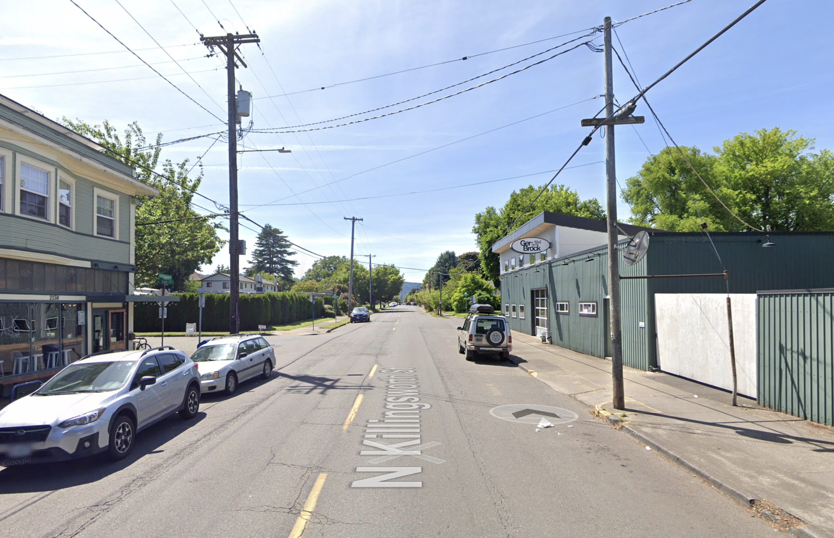
As families were loaded into buses and trains during the “evacuation,” heart-breaking decisions were made about the disposition of lands and businesses. Beginning in the 1930s, the Shiogi family had operated a market known as “Publix Market” at the corner of North Killingsworth and Gay Street in North Portland (the storefront that today houses Milk Glass Market, 2150 N. Killingsworth). When the Shiogis were removed to the Minidoka Internment Camp in Idaho, they “gave” their store to neighbors for safe-keeping.

In the fall of 1945, upon returning after the war, the family attempted to re-open the store but found anti-Japanese sentiment in Portland to be too strong. Younger members of the family—daughter Mary and her husband Cliff Tadakuma—who had endured the internment experience only to be discriminated against at home in Portland, moved to Hawaii for several years in search of a more hospitable environment. Mary found work as a housekeeper. Cliff became a gardener on a large estate.

In 1950, Mary and Cliff Tadakuma—with their young daughter Joyce who had been born at Minidoka—returned to Portland from Hawaii and decided to try again to reopen Publix Market, but this time in a different location farther out Killingsworth, in northeast Portland.

Mary had grown up in Portland, a first generation Japanese-American. Cliff had grown up in Maui and graduated from Oregon State University with a degree in chemical engineering (and where the two had met). While their interests and expertise were not necessarily in running a small grocery store, it was a better option than housekeeping and gardening when they returned to Portland.

The couple leased the old wood frame building at the northeast corner of NE 42nd and Killingsworth. The store was adjacent to a densely populated trailer court established during the booming war years, and the surrounding residential neighborhood was growing as well. With the help of Mary’s parents Lori and Hood Shiogi who had run the market when it was located in North Portland, Mary and Cliff set about re-establishing Publix Market.

Daughter Joyce Tadakuma Gee was six years old at the time and recalls that her family lived in the back of the store. Behind the shelves and retail area were two small bedrooms, a bathroom a living room and a small kitchen. Joyce—who is a long-time Portland resident—attended nearby Whitaker Elementary School, located on Columbia Boulevard. “I remember being so envious of classmates of mine who had ‘real’ homes to live in,” she recalled when interviewed in 2020.

Neighbor Doris Woolley grew up on Jarrett Street just north of Publix Market, and remembered that everyone referred to the store simply as “Cliff and Mary’s.” Doris—who passed away in 2020 at age 92—recalled that all of the residents of the trailer park and neighbors north of Killingsworth were loyal to Cliff and Mary and would only shop at Publix Market, even though there were two other small markets nearby.

“It was a great store and they had pretty much everything you wanted,” Woolley recalled.  “Plus, they would let you run an account. In those days a lot of people would charge their groceries during the week and pay for them once they got their paychecks at the end of each week.”

Asked about her recollections of Cliff and Mary’s Japanese American origins and any tensions during the post-war years, Woolley remembered only that everyone liked Cliff and Mary. “They were very kind to everyone.”

Mary Tadakuma died in 1954. Cliff remarried and moved with daughter Joyce to Hood River, where he ran a grocery market until his death in 1978.

1958 Looking North

This 1958 photo (courtesy of City of Portland Archives, a2005-001-984) looks north on NE 42nd just south of Killingsworth. Publix Market is gone, replaced by the Panarama, a liquidation store. The Chevron service station across 42nd to the west has changed hands since the earlier photo and was being operated by Rod Martin. Behind the Panarama Market was the parking lot and sign for the brand-new Safeway store. The intersection was controlled by stop signs facing NE 42nd Avenue.

The white clapboard market building was built about 1927 and was initially operated as a grocery store by Bill and Jennie Batson. Panrama survived the 1957 opening of Safeway, but by 1961 the building had been demolished and replaced by a parking lot and service station.

Safeway Opens in January 1957

A combination of changes in the grocery business—with tendencies to larger chain stores—and an increasing population and market made the corner a natural for the Safeway store, built on the site of what had been the trailer park and small grocery store in the 1940s-1950s.

The store opened in January 1957 as part of a three-store opening blitz in the Portland area, as described in this full page ad from The Oregonian on January 10 1957.


1964 siting of John Adams High School

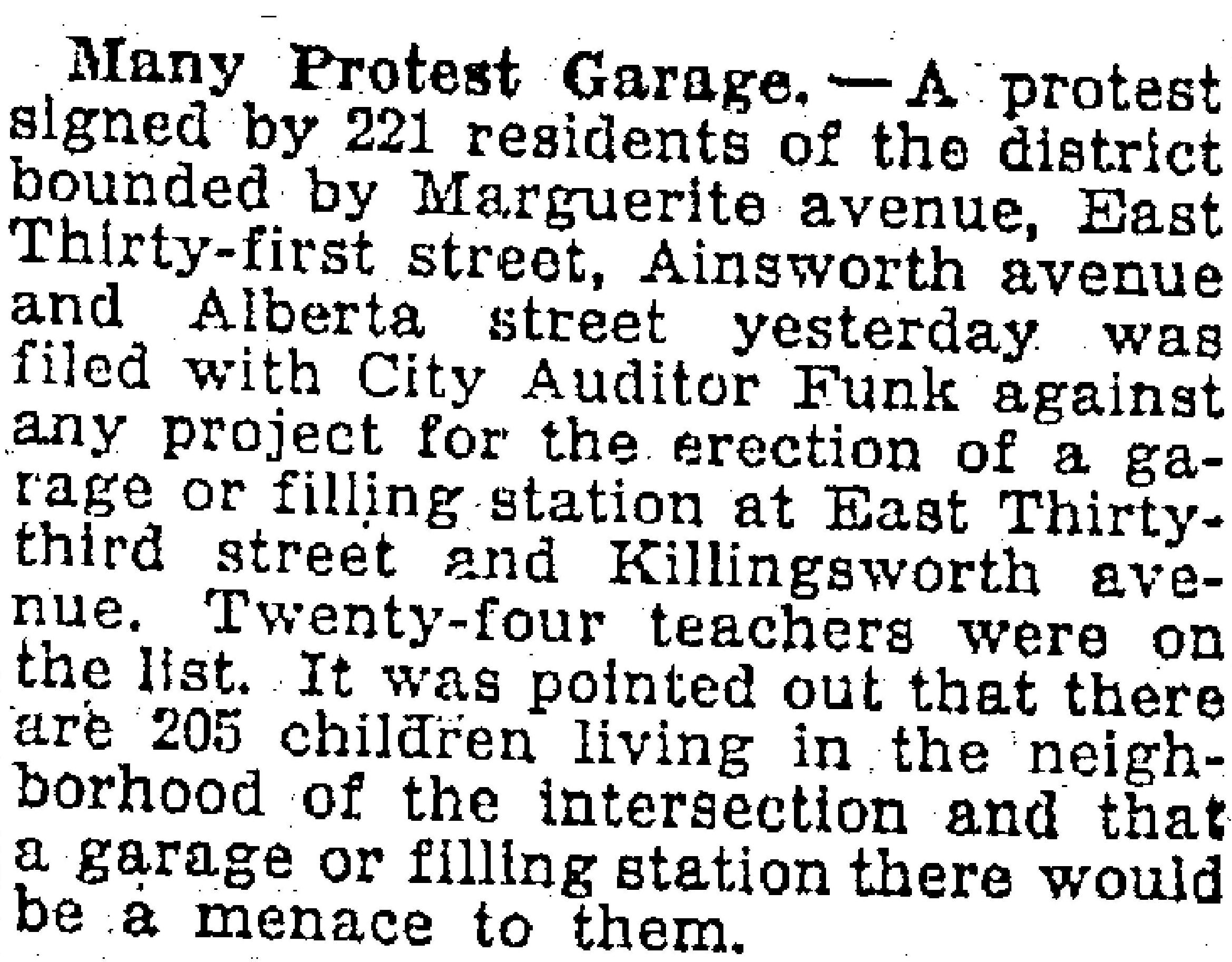
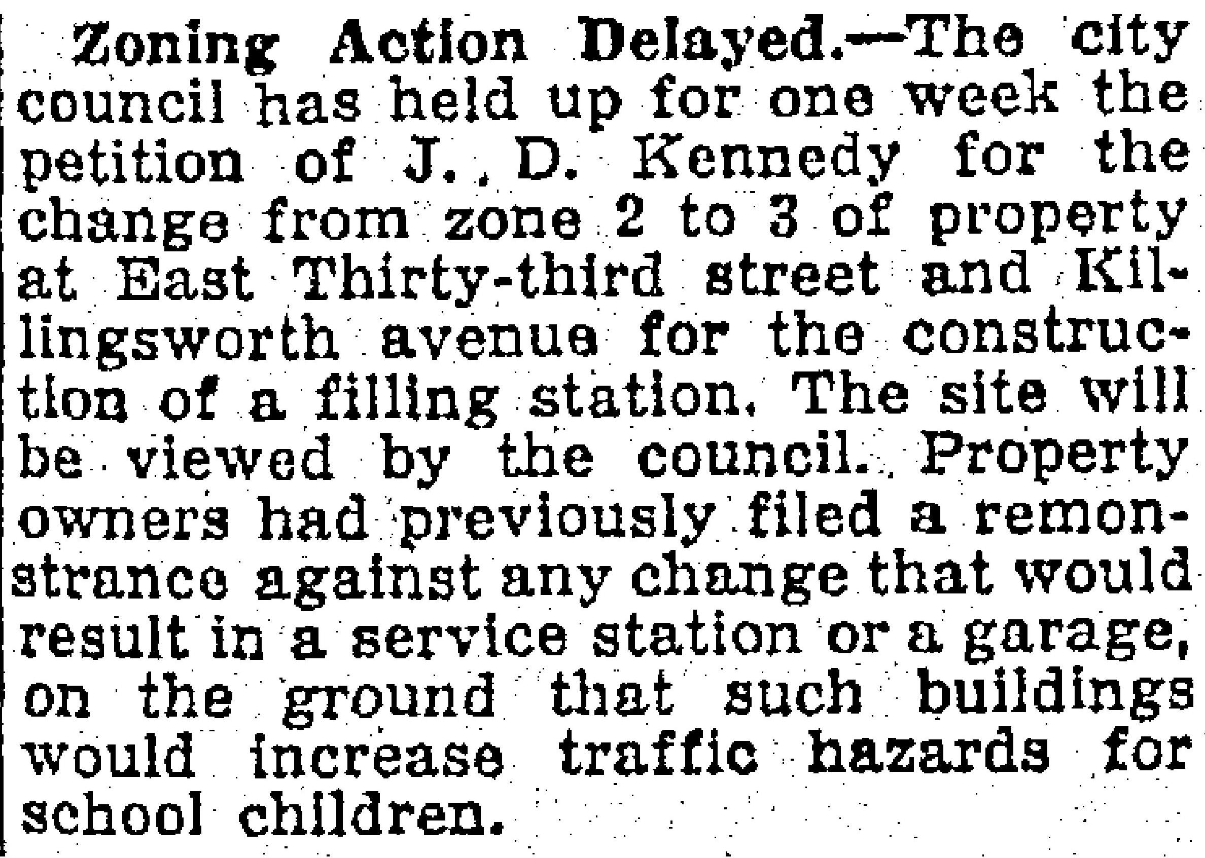
Construction of John Adams High School just southeast of Fernhill Park in the mid-1960s caused quite a stir and protest from the neighborhood. More than 200 angry neighbors turned out at a Portland School Board meeting on September 14, 1964 to share their disbelief that the School Board would demolish and relocate more than two dozen homes, three duplexes, a local greenhouse/nursery known as Knapps and a PGE substation to make room for the school.

From The Oregonian, September 3, 1964. The homes and businesses inside the dotted line were demolished or relocated to make room for John Adams High School.

From the Oregon Journal, September 3, 1964. Greenhouses for Knapp’s Nursery on NE Simpson are visible in the photo to the left, which looks north on NE 42nd.

The emotion and sense of loss in the letters and petitions submitted to the school board make for tough reading. Despite this strenuous protest, demolition went ahead, construction followed, and John Adams High School opened in September 1969.

From the Oregon Journal, September 15, 1964

A dozen years later, when high school enrollment dropped in the early 1980s, the building was repurposed as a middle school and operated for another 18 years before being closed in 2000 due to health concerns about mold and radon gas. The building sat empty and was frequently vandalized until being torn down in 2006 leaving the large open space south of the track. Newcomers to the area today might not even know that vacant piece of ground south of the track was once a high school and middle school.

1965 Looking South

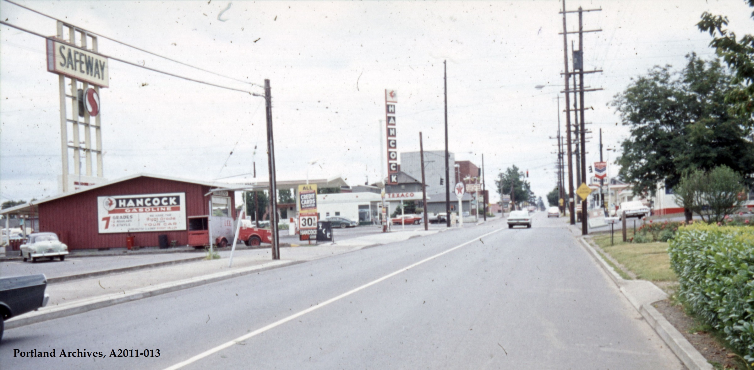
This view from 1965 looks south along NE 42nd Avenue. The tall buildings in the background are the relatively new St. Charles Church. The intersection has a traffic signal, and each corner features a different gas station: Texaco, Hancock, Mobil and Chevron. The Hancock building stands about where the Publix Market building once stood. The Safeway sign looms large over the intersection. Photo courtesy Portland City Archives, a2011-013.

Safeway operated in this location until about 1972, when the property was acquired by Portland Community College and the building remodeled to become a workforce training facility. In 2024, a completely new PCC building at the corner is now the Portland Metropolitan Workforce Training Center. And construction is underway just to the east on an affordable housing development managed by Home Forward that will include 84 units.

From open space that once provided wildlife habitat and material needs for Indigenous people; to homestead and farm fields that supplied a growing population of newcomers; to park land, school grounds, green houses, family homes and retail; and today affordable housing, workforce development and some great restaurants; this place has continued to evolve, layer upon layer of history and of life.

From farm fields to city lots – development arrives at 42nd and Killingsworth

Detail from a 1908 Portland Railway, Light and Power Map showing the vicinity of 42nd and Killingsworth, in the center of the image. The Jorbade subdivision was platted at the intersection in 1908. The western “County Road” is today’s NE 33rd. The eastern “County Road” is NE 42nd. Rose City Cemetery appears in lower right (note that Cully passes through the cemetery). The cross-hatch lines indicate mile increments distant from downtown. The Irvington Park plat is part of today’s Concordia neighborhood. The Alameda Park Addition had not yet been platted and is shown as open fields.

Continuing from our first installment exploring the layers of history at NE 42nd and Killingsworth…

The early years of the 20th Century brought a sea change to the Portland area: dramatic growth in population and a spike in residential and commercial construction that followed; a steady increase in the area’s rail and river shipping and port activity; extension of an interconnected electrified streetcar system; and arrival of the automobile. The 1905 Lewis and Clark Centennial Exposition drew national and international attention to Portland, attracted business and new residents, and set Portland on a growth curve that would remake the region.

During those early years, the vicinity of NE 42nd and Killingsworth was still a rural crossroads. Killingsworth (which was gravel) didn’t go farther east: it dead-ended into NE 42nd Avenue, which was known only as “County Road” up until the late 19-teens. Maps show the area much like the 1897 USGS map until the second decade: fields all around and less than 30 buildings—many of them barns—within a one-mile radius of the intersection.

But real estate speculators and some landowners could see the writing on the wall. Streetcar lines were working their way east, and new subdivisions and commercial areas were being planned and built. By 1912, a high volume of residential construction was underway in nearby Alameda, Beaumont and Rose City, all of which had been similar open fields and dirt roads.

Open lands are platted for homes, setting the stage for the area we know today

By 1909, real estate speculators Commodore Perry Jordan and Theodore August Garbade had purchased a portion of the old Isaac and MaryAnn Rennison Donation Land Claim at the intersection of today’s NE 42nd and Killingsworth. The two planned to sell residential building lots from what had been open farm land. Jordan and Garbade called their planned suburb “Jorbade,” and filed this plat with Multnomah County. The western edge of the plat is NE 42nd Avenue. Important to note that Killingsworth wouldn’t go through for at least 10 more years. These lots would be just that–vacant lots–for many more years.

A few years later Jordan and Garbade acquired the lands on the opposite corner and were ready to convert them too from open fields to a subdivision. In 1911 they platted the Killingsworth Avenue Addition, from Killingsworth south beyond Emerson, between NE 37th and NE 42nd.

A bit farther west, local resident and real estate speculator John D. Kennedy was a few steps ahead of Jordan and Garbade. He had bought old homestead lands in 1880 believing that Portland would one day expand east; in 1890 he platted the Kennedy Addition, while this area was still part of its own town: East Portland. Here’s a detailed look at Kennedy and his adjacent nearby lands.

The Stokes Tract followed Jorbade and the Killingsworth Addition in 1920, north of Killingsworth and east of 42nd, establishing the graceful arc of Ainsworth and Simpson Court. This area retained a rural feel: “Live in the country and be independent” reads the advertisement.

Other subdivisions followed including tiny View Park in 1923, on the north side of Killingsworth between 36th and 40th:

Interest in these planned subdivisions was not particularly strong until the late 1930s: their distance from downtown, their presence outside the city limits and about a mile walk from the nearest streetcar line (despite what the advertisement said about being on a 5 cent fare line); their rural nature including gravel roads and surrounding fields and orchards may have made them less attractive, even if the prices were lower. But as Portland continued to expand, and the automobile became more prevalent, would-be homeowners were ready to buy and build.

Classified advertisements for properties adjacent to the intersection report a variety of crops growing at the time: orchards of Bing, Lambert and Royal Anne cherries; English walnuts; Bartlett pears; prunes and plums; apples; rows of strawberries and raspberries.

Often referred to as “truck farms” because the produce was trucked to market (and some of it was sold out of the back of trucks at busy intersections and small markets around town), these surrounding fields produced fruit and vegetables for Portland households. One farm near the corner of what is today’s NE 41st and Holman was owned and run by a Japanese immigrant family, as were others in the area. During WWII, Japanese farming families across the Pacific Northwest were removed from their land and placed in internment camps in southeast Oregon, central California, Idaho, Utah, Wyoming and Colorado.

Portland Air Base leads to new roads and new residents

By 1935 air freight and airline passenger traffic had overwhelmed Portland’s first airport—located on Swan Island—and the city spent $300,000 to purchase a 700-acre site adjacent to the Columbia River where today’s Portland International Airport resides. With a grant from the Works Progress Administration, workers drained the former floodplain and dumped more than 4 million cubic yards of sand across the site. The airport opened in 1941. During the hundreds of generations of indigenous presence prior to European contact, these wetlands had been both seasonal home and food source.

Following declaration of war in late 1941, Army Air Base operations at the site were dramatically increased and Portland became a regional magnet, attracting tens of thousands of workers and their families to multiple war-related industries across the Portland area. An immediate demand for housing, combined with a newly-improved road network and the availability of open land in this area so close to the airbase, fueled interest.

A small expression of the interest was a long row of connected cabins dubbed the “tourist cabins” and an adjacent business called the Spur Tavern at the northeast corner of NE Holman and 42nd avenue. Built in 1942 as temporary housing for the great influx of people, the residences and tavern became a landmark of sorts. Read more about the Tourist Cabins and the Spur.

City buys old farms to create Fernhill Park

After voters approved a property tax levy in 1938 to create more parks and playgrounds for a growing Portland, the city set out on a 10-year process of buying the hills and gullies northwest of 42nd and Killingsworth, starting out in 1940 with a 10-acre parcel owned by the Jackson family right in the middle of it all.

Prior to acquisition, several dirt roads criss-crossed the north side of the area, one even ran right up the bottom of the gully at the heart of today’s off-leash area in the northeast corner of the park, pausing at a wide spot that served as a dump and debris field where car bodies and all manner of junk were strewn.

It wasn’t an official dump, but more like a secluded out-of-the-way place where residents from the surrounding area dumped unwanted items. In the late 1930s and early 1940s, when the NE 42nd Avenue connection to Columbia Boulevard was built, some of the dirt fill needed to make the grade change for the overpass was dug out from and supplied by the gully on the east side of the park along today’s NE 41st Avenue.

As the park took shape through the late 1940s and early 1950s, some locals referred to it as Ainsworth Park, a name that appears frequently in real estate advertising of that era. By the early 1950s, most of the open land to the north of the park had been converted to subdivision (the Vanlaeken and Leitritz plats). NE Highland Street was put through the middle of working farmland as the area was transformed into suburbia. By June of 1951 when most of the park buying was done, the city had invested $60,479 total for all of the parcels and had acquired 25.95 acres. Read more about the origin of Fernhill Park.

Aerial photographs = time travel

As a reward for reading this far, and as preface for the next installment, here’s a series of aerial photos that allow us to witness change. Each of these is fascinating, so click in for a detailed view. Observations follow each image. Aerial photos courtesy of the University of Oregon Map and Aerial Photography Library.

In 1936, the unplowed lowlands of today’s Fernhill Park show up just left of center, and the arc of Simpson Court and NE Ainsworth feed into NE 42nd. No viaduct yet over Portland Highway. The arrows indicate locations of three small mom-and-pop groceries. Note that Simpson goes through east-west, across the middle of today’s Fernhill Park.

In 1939, more houses are showing up, and orchards in the center of the photo are maturing.

In 1948, the 42nd Avenue viaduct is in place (not pictured) connecting NE 42nd to the new Portland Airport. Houses continue to replace open fields. The greenhouses at Knapps Nursery appear west of NE 42nd at Simpson. Orchards near NE 37th and Killingsworth are replaced by homes.

In 1951, a trailer park appears at the NE corner of 42nd and Killingsworth in what were once open fields. Significant new home construction is evident north of Killingsworth and west of 42nd. The flat playing field at the south end of Fernhill Park begins to emerge from the former agricultural fields north of Simpson, and west of 42nd. Construction is underway on the new St. Charles Church and school.

In 1961, the trailer park is replaced by a large Safeway store and parking lot at the corner of 42nd and Killingsworth, which opened in 1957. A baseball diamond is clearly visible in the new Fernhill Park. Orchards and open agricultural fields are gone. Simpson still goes through west of Killingsworth. South of Simpson in this area, 26 homes, three duplexes, a PGE power substation, and Knapp’s greenhouses and nursery are soon to be demolished or moved–over the strenuous objection of neighbors–to make way for John Adams High School.

In 1971, John Adams High School is in place, replacing a portion of the open areas of Fernhill Park and most of the homes between Killingsworth and Simpson west of 42nd. Simpson no longer goes through west of 42nd. Acres of parking are available west of the Safeway store at 42nd and Killingsworth.

By 2020, John Adams High School (later known as Whitaker Middle School) was demolished in 2006, but the track remains. Neighborhood street tree canopies are filling out. Safeway is closed and the buildings at the northeast corner of 42nd and Killingsworth are now gone.

Next: The changing retail face of the intersection: from Cliff and Mary’s to Safeway and beyond

Time travel deep dive at NE 42nd and Killingsworth

The intersection of NE 42nd and Killingsworth can feel like it exists on the way to somewhere else. But this crossroads has its own rich history that runs deep.

NE 42nd and Killingsworth, looking northeast. Fall 2023, Google streetview.

It’s worth slowing down time a bit to be able to see and explore the chapters here, which run back through commercial retail and early neighborhood development to wide open fields of berries and orchards, further back through the homestead era and even down slope toward the Columbia River and the slough wetlands that have been known and inhabited by Chinookan people since time immemorial.

This is the first of a three-part exploration to spark your imagination about the layers of history here. In this first installment, we’ll overview the arc of the story. In the second installment, we’ll take an illustrated deep dive into the subdivision years between 1900-1940 when everything was changing for the neighborhoods around the crossroads. Our last installment will explore the changing look of the intersection itself from the 1950s-1980s: gas stations and mom-and-pop groceries, greenhouses, a Safeway store, a trailer park, Adams High School and more.

Today, both NE Killingsworth Street and NE 42nd Avenue are well-used surface streets in the Northeast quadrant of Portland. The traffic-controlled intersection where they cross—poised at the northern edge of the 42nd Avenue / western Cully neighborhood commercial area four miles from the downtown core of the city center—features restaurants, bus stops, a convenience store, direct access to a city park and a brand-new workforce training center operated by Portland Community College. In fall 2025, Home Forward will open 84 units of affordable housing here. This is a busy place.

Early slopes above the Columbia Slough

For millennia the uplands south of the Columbia Slough and Columbia River were covered by a mixed forest of Douglas-fir, hemlock, cedar, alder and maple. Periodic fires, windstorms and outbreaks of insects and disease created openings in the forested canopy. The upland plateau that would eventually become the vicinity of today’s NE 42nd and Killingsworth sloped gently down to meet a vast flood plain, which followed an east-west line at the foot of the slope traced by today’s NE Columbia Boulevard.

Situated between the bottom of the slope and the main channel of the Columbia River just to the north was an interconnected flood plain mosaic of wetlands, ponds, marshes and off-channel waterways. Chinookan seasonal gathering places and dwelling places thrived here for thousands of years.

“Interior of Ceremonial Lodge, Columbia River,” an 1846 oil painting by Paul Keane, who traveled among the Chinook villages of the lower Columbia River.

Explorers, trappers and traders passed by on the Columbia River in the early 1800s intersecting the lives of indigenous people who had known this area since time immemorial. Early white traders introduced successive epidemics of disease, disruption and depredation, and by the 1830s the Chinookan people’s settlements in this area and their ways of life had been dramatically changed. By the late 1840s, Oregon Trail settlers arrived in the area; this immediate vicinity was homesteaded by several families practicing a mix of agriculture, trade and subsistence. Forests were removed, roads were constructed, and homes and barns built.

Surveys gridded the land

With the opening of the Oregon Trail in the mid 1840s and arrival of an increasing number of outsiders seeking land for farms and homesteads, the U.S. Government established a systematic process to map and identify lands that had been mostly cleared of indigenous people that could be granted to newcomers. Survey crews got to work here in the Portland area in 1851 establishing the Willamette Meridian, a systematic grid of townships, ranges and sections across the territory and the Western U.S. that promoted the availability of lands.

Today’s intersection of NE 42nd and Killingsworth exists at the corner of four sections of the Willamette Meridian: Township 1 North Range 1 East, sections 13 and 24 to the west; Township 1 North, Range 2 East, sections 18 and 19 to the east. Here is a compilation of those two original survey maps (click in for a closer look, they are fascinating). Observations below.

On the left is Township 1 North, Range 1 East. Notable are the early grid of a young Portland in the lower left; the location of past forest fires; the proximity of early trails and the complex waterways that make up the Columbia Bayou to the north. The blue arrow indicates the approximate location of today’s NE 42nd and Killingsworth. On the right is Township 1 North, Range 2 East. Notable here are the “wet prairie” description of the Columbia Slough bottomlands in the vicinity of today’s Portland International Airport; the road running northeast, predecessor of today’s Cully Boulevard; the surveyor’s descriptors—land gently rolling, soil 2nd rate, gravelly. Timber, Fir, Hemlock, Maple—describe vegetation in the area at the time; Rocky Butte shows up as the raised topography in the center of the map.

In October 1851, surveyor Butler Ives and his crew walked all through this area in order to draw these maps, and characterized what they saw like this:

Upland situated in the middle portion of the township is gently rolling and is elevated from 50 to 100 feet above the adjoining bottoms. The soil of the above is nearly uniform and good second rate clay loam and some gravelly in the northeast portion south of the Columbia bottoms.

The bottom lands both of the Willamette and Columbia, is from 5 to 15 feet above low water, the most elevated being along the banks of the rivers and bayous; they are subject to an annual inundation lasting from 1 to 2 months in the summer season, leaving only a few of the higher places dry. They are mostly open grassland. Soil rich alluvial and badly cut up with bayous, stagnant ponds and lakes which render nearly one half of them unfit for a cultivation.

The timber on most of the uplands is heavy and varies from 1 to 2 and in some instances to 250 feet in height. It is principally fir with a little maple, cedar, hemlock and dogwood interspersed.

The undergrowth is vinemaple, maple, brush and is usually thick; there is considerable dead and fallen timber caused by fire which has run through most of this Township.

In the bottoms is ash, willow balm, Gilead, crabapple with oak, and is found skirting the banks of the rivers and bayous. The undergrowth is in thick mixture patches of hardwoods, rose bushes gooseberry bushes and vines. The Columbia bayou is deep in most places and will admit boats drawing several feet of water. The other bayous are generally shallow.

As more people arrived, the surrounding lands were further divided, sold and developed. Wetlands to the north were drained for agriculture. More roads were built and active steamboat commerce developed on the nearby Columbia River. In 1882, a short stretch of dirt road in the growing nearby town of Albina was dedicated as Killingsworth Street, named for prominent real estate developer William Killingsworth. One year later—1883—the Oregon Railway and Navigation Company opened an east-west rail line passing nearby to the south that connected Portland with a growing network of regional and national railways.

A patchwork emerges

Our crossroads was well outside the eastern boundary of East Portland, which in 1891 consolidated with the towns of Albina and Portland (on the west side of the river) to form the single City of Portland. A rough north-south gravel trace known as the County Road (today’s NE 42nd Avenue) was carved out connecting the east-west predecessor of today’s Fremont Street with the east-west road along the Columbia Slough (today’s Columbia Boulevard). Growing population and commerce continued to boost Portland’s expansion. By the turn of the century, lands that 50 years earlier had been taken from indigenous people and deeded by the federal government to a handful of incoming families were being subdivided and sold into hundreds of parcels.

A patchwork of agriculture and development dotted the surrounding landscape with small farmsteads of orchards, berries and vegetables interspersed with homesites. Below is a detail from a USGS 1897 map of the area (star shows location of NE 42nd and Killingsworth). Notable here is that Killingsworth does not go farther east; development does not proceed much farther east than NE 7th; scattered farmsteads occupy the area of today’s neighborhoods; the Irvington race course at NE 7th and Fremont shows up in lower left.

Because of the area’s distance from the downtown core, its location beyond easy access to the streetcar system which promoted development, and its agricultural productivity, the crossroads remained largely rural until the opening of Portland Airbase in 1941, which was then a brand-new facility built on the reclaimed floodplain wetlands just south of the Columbia River.

Post-war boom ignites interest

The wartime expansion of manufacturing, residential growth and military operations drew new attention to the area, leading to transportation improvements and northern extension of NE 42nd Avenue with a viaduct over the Columbia River Highway, making it a major throughway from the eastside to the airbase. Residential and commercial development followed. Portland’s post-war housing boom in the 1950s led to further development, including more subdivisions, construction of a busy trailer park at the northeast corner of the intersection, and city acquisition of remaining nearby farm lands into what would become today’s Fernhill Park just to the northwest.

By the 1960s the area had been annexed into Portland proper. A commercial hub had developed at NE 42nd and Killingsworth including large and small grocery stores, service stations, bars, restaurants and light manufacturing. In the mid-1960s, the Portland School Board condemned a portion of the surrounding area to build John Adams High School, in direct opposition to residents’ wishes, razing homes and businesses. The school complex was later transitioned into Whitaker Middle School, and eventually torn down in 2006 due to changing student demographic needs and concerns about radon gas and the presence of unhealthy black mold found throughout the building.

Next: From farm fields to city lots – plats and development arrive

In 1911, it’s snowing

With thoughts about snow in the air, let’s turn back the clock to 1911.

From time to time, AH reader and Portland photo collector Norm Gholston sends along a gem or two from neighborhoods we know well—and some we’re still learning about. Here’s a killer image Norm shared recently, a “real photo” postcard from 1911 that shows a mom and pop grocery from Killingsworth Avenue at the southern edge of today’s Arbor Lodge neighborhood.

There’s so much to see and think about in this photo. Click in for a good look and we’ll share some insights:

Photo courtesy Norm Gholston

Snow! Those four-legged traction devices look pretty steady, don’t they?

As the writing on the wagon to the left says (and the numbers on the window to the left of the front door suggest), this is 155 Killingsworth Avenue, which before Portland’s Great Renumbering was actually 155 West Killingsworth. When you map that out today, it takes you to 2225 N. Killingsworth, located on the north side of the street just east of the N. Omaha Tree Way, a four-block-long Arbor Lodge boulevard.

Here’s where this is today, first by map, and then by Google Streetview


In this contemporary Google Streetview image, the horses and wagons would be parked near the utility pole in front of the white gate.


Detail from Sanborn Plate 521 shows the area in 1924. Arrow indicates location of Ockley Green Groceries and Meat.

Interestingly enough, there must be some remnant of the old market building underneath the existing structure of the auto shop that exists at that address today, because a plumbing permit still on file for that address tracks back to construction of the market building in July 1909, and tells us it was indeed a store.

The wagon on the right, with the grinning driver in his great gauntlet gloves, buttoned-up tunic and basket of greens, is driving for Pierson Brothers Grocery, also housed at 155 W. Killingsworth (look very carefully at the writing on his wagon). What was in that drinking jug on the far right next to the kerosene can?

Neither the Pierson Brothers nor Ockley Green Groceries and Meat appear in any of the Polk city directories either side of 1911 when this photo was taken, but don’t tell these guys that. We’ve scoured through newspapers and other business listings of the era and don’t find reference to these businesses either, though the grocery operated for years after the photo was taken. Help wanted ads from 1910 sought an experienced meat cutter to come in on Saturdays. Perhaps that’s when the fresh meat arrived from the nearby Portland Union Stockyards.

Be sure to appreciate the school girls: the younger girl on the right pulling a sled; both are layered up in their wool coats and hats and good winter boots.

Some clever volunteer editor has scratched out the words under the sign near the stairs, readable between the two utility poles. Yes, we can read “Grocery & Meat Market.” No, we can’t read whatever you crossed out. Was it a person’s name? The scratch-out edits were applied directly to the postcard, not to the actual Foster and Kleiser sign. Why?

Thanks to the 1910 census, we know who is living up those unpainted stairs, behind the open screen door. It’s Frank B. and Margaret Ford, who built the building. Ford was a real estate speculator dealing primarily in grocery stores like this and other simple first-floor commercial properties. Frank and Margaret bought and sold many properties on the eastside over the years and when things got tight, Frank took some liberties with certain documents, which got him arrested in 1929 for real estate fraud. But in 1909, he knew the right place to build a market with the new and booming Overlook neighborhood all around.

Frank B. Ford and his partner Theil also built the commercial block across the street which now houses the Milk Glass Market (which is well worth a visit by the way for a coffee and look around at the neat old market building insides). Back to the photo, look carefully at the reflection in the market window panes and you might even be able to make out the form of the building across the street and its clapboard siding. Check out the Sanborn plate again (and the streetview) and you can see the Milk and Glass Market building directly across the street.

Be sure to note the rails running east-west on Killingsworth, visible in the far left bottom of the photo. This is the St. Johns car line. In the 1890s,  somewhere nearby behind the photographer was the re-load point where the steam train came and went to St. Johns and riders transferred to the electric trolley line that ran east and then south toward Portland. A station was built here–at the corner of Killingsworth and Omaha on the south side of the street–and it was called the Ockley Green Station; later it served the electric trolley that went all the way through to St. Johns. You’ll find dozens of references to it in early newspapers of the day. Real estate ads selling houses or renting apartments all say “near Ockley Green Station.” No need for an address or even a cross-streets, everyone knew where Ockley Green Station was (though, thankfully, some did explain Omaha and Killingsworth was the spot).

There’s another mystery we’ve been puzzling over that will remain unsolved for the moment (we’re not without our hunches): the name Ockley Green taken by the station and the market, and eventually the school.

Here’s what we know for sure:

  • Ockley Green was the name of the station from early days. It was not named for a person. There is no person in any of the Portland decadal censuses during that time or in any city directory of that era that we examined with that name.
  • The school that exists today at Ainsworth and Interstate (10 blocks to the northeast) built in 1925 takes its name from the Ockley Green Station. Documents from the Portland Public School archive tell us this fact. The original building was actually built as “Multnomah Public School” in 1893 at N. Missouri and Shaver, but was moved to Interstate and Ainsworth about 1901, and its name changed to Ockley Green (for the station) in about 1909. The first building was demolished and the one we know today built in 1925. But that’s another story.
  • There is no underlying plat or development plan with this name, no streets or other features. It was more of a “district” than a specific place.
  • Ockley is a picturesque town in Surrey in southern England with a much-written about commons or “green.” Even today, Surrey’s heritage authority reports the most important feature of little Ockley town…”is the long, broad green, which is said to be one of the most impressive in southern England.” Both the green and the town were celebrated in writing and in art during the 1800s. Here’s an example:

From London News, 1851.

We’ve had a good look around on this naming mystery, talked to the Arbor Lodge Neighborhood Association, consulted all of our usual helpful print and public document sources and even stumped a few research librarians. The definitive story behind origin of the name Ockley Green has apparently slipped away, at least for the moment. We have our hunches: immigrant Portlanders with roots in Surrey saw something about the open landscape of the early neighborhood that reminded them of home, and it was comforting to have the place and the memory with them. We completely understand this.

Meanwhile in 1911, it was snowing at 155 West Killingsworth and the grocerymen were still delivering, the kids ready for adventure.


NE 33rd and Killingsworth: From rural road to busy intersection

In our ongoing pursuit of insight about the early days of Northeast neighborhoods, we’ve come across a zoning change petition filled with photos and maps from 1929 that allows an interesting glimpse into the evolution of today’s busy intersection at NE 33rd and Killingsworth in the Concordia neighborhood.

We’ll whet your appetite with this 1929 photo of a fine bungalow, owned by Frank and Louella Watson that was located at the northwest corner of NE 33rd and Killingsworth (facing 33rd), on property now occupied by the Mud Bay pet store.

Looking west across NE 33rd at the Watson house, a tidy-looking bungalow surrounded by highly manicured hedges and gardens, that occupied what is now the parking lot for Mud Bay. Photo taken on August 15, 1929. The sidewalk running off into the distance at left parallels Killingsworth. Photo courtesy of Portland City Archives, A2001-062.57.

At the turn of the last century, John D. Kennedy owned much of the land between Killingsworth, Ainsworth, NE 33rd and NE 42nd, which he platted as the Kennedy Addition. By 1910, he was carving up the fields into building lots and a handful of houses were being built. In 1913 he sold the city a four-acre parcel that is now Kennedy School, which opened in 1914. Kennedy knew an emerging neighborhood would need a school and he was, after all, in the business of selling lots for homebuilders.

The Oregonian reported at the time this part of NE 33rd—which was also known as the Sunderland Road north of Prescott—was still unpaved and mostly used for moving cattle and sheep, and that the surrounding area was heavily wooded with only a few scattered houses.

By the mid 1920s, more homes had been built in the area, particularly along NE 33rd. At the southwest corner of 33rd and Killingsworth was a small Red and White Market. At the southeast and northwest corners, bungalows had been built. At the northeast corner of Killingsworth and 33rd pictured below, Kennedy owned an open field that once housed a barn (a kind-of local landmark known as “Kennedy’s Barn”). You can see some of the wood left over after the barn’s demolition.

Looking east across 33rd at the open lot at the northeast corner of 33rd and Killingsworth where Kennedy’s barn once stood, June 15, 1928. The street running off into the distance at right is Killingsworth. Taken from the Watson home pictured above. Photo courtesy of Portland City Archives, A220-062.54. Contemporary photo showing the same view today.

Even though the area still had a strong rural residential feel, Kennedy could already visualize how things would go: the school and homes were ripe for their own commercial district. So, in the summer of 1929 he put the re-zoning wheels into motion to get his parcel ready for commercial development.

Here’s a look at the area from a 1925 aerial photo:

Detail of a 1925 aerial photo. Kennedy School is visible in the upper right corner. Kennedy’s field appears just above the “NG” in the original hand lettering on the photo (now a 76 gas station). The red dashed line indicates the location of present day New Seasons Concordia. Click for larger view. Aerial photo courtesy of City of Portland Archives.

In 1929, Portland’s zoning code was fairly simple: Zone 1 was for single-family residential use; Zone 2 was for multi-family residential use; Zone 3 was for business and manufacturing; and Zone 4 was unrestricted. (Here’s a link to a great history of zoning in Portland).

At the time, the northeast corner of the intersection owned by Kennedy had been zoned for residential use, but he wanted it to be Zone 3 to develop the property for commercial use. In his petition, Kennedy described his vision to build a commercial corner just like the one in Beaumont at 42nd and Fremont (he actually included a photo of that building), or a filling station. Kennedy pledged that if the zone change was allowed, he would personally see to it that “no cheap construction will be permitted,” and that “it will be so kept that it will be an attraction to any business Street intersection or residence district.”

Neighbors weren’t wild about the idea.

On October 12, 1929, adjacent property owners submitted a hand-drawn and color-coded map that recorded exactly how they felt. Owners with properties shaded green wanted the area to stay restricted to residential. Those shaded yellow were in favor of Kennedy’s petition for zone change to commercial. Have a good look and you’ll figure out pretty quickly which properties were owned by Kennedy. It’s also interesting to note the third category (yellowish green), which were neighbors in favor of the Kennedy petition at first but who then changed their minds.

Map drawn by neighbors showing opposition to rezoning of the Kennedy property for commercial use. Click to enlarge. Courtesy of City of Portland Archives, File A2001-062.

Here’s where it gets visually interesting.

Along with their map, neighbors submitted photographs to help the Planning Commission understand the residential character of the neighborhood and the potential impact of a zone change. We paired these with similar views photographed on a snow day in early February 2019.

5434 NE 32nd Place (formerly 1160 E. Glenn Avenue, the Svensen family home). The southeast corner of NE 32nd Place and Killingsworth. Photographed on August 14, 1929. Courtesy Portland City Archives, A2001-062.60.


5506 NE 32nd Place (formerly 1150 E. Glenn Avenue, the Eaton family home). The northeast corner of NE 32nd Place and Killingsworth. Photographed on August 14, 1929. Courtesy Portland City Archives, A2001-062.61. We wonder if the homeowner realizes the house once had an extended front porch and pergola, and a completely different siding material.


5526 and 5606 NE 34th Avenue (formerly 1166 and 1168 E. 34th Avenue, the Nellie White and C.C. Cooper family homes, respectively). Photographed on September 19, 1929. Courtesy Portland City Archives, A2001-062.65.


What was then a newly constructed building at the southwest corner of 33rd and Killingsworth, known as Hollinshead’s Corner, named for the developer who built the building. Looking southwest across Killingsworth. Note the entry archway and façade that is still standing. Photographed on September 30, 1929. Courtesy of Portland City Archives, A2001-062.67.


The market at Hollinshead’s Corner, looking west across 33rd, just south of Killingsworth. The edge of the decorative archway is visible at far right. Photographed on September 30, 1929. Courtesy of Portland City Archives, A2001-0672.66.


5343 NE 33rd and 5407 NE 33rd (formerly 1137 and 1139 E. 33rd Avenue, homes of Mrs. Mercier and H.C. Wright, respectively). Directly across from present day Canon’s Ribs. Photographed on August 30, 1929. Courtesy of Portland City Archives A2001-062.63.


The neighborhood submitted these photos and the map as the battle about Kennedy’s requested zoning change played out in late October 1929:

From The Oregonian, October 29, 1929.

Because of the local turmoil and the fact that any Planning Commission recommendation would have to come before City Council for a vote, the electeds took the item off the agenda for several months, and then wanted to come out and have a look for themselves. Action on Kennedy’s petition dragged into 1930.

From The Oregonian, March 15, 1930.


When City Council visited the site in March 1930, they had in hand the following do-pass recommendation from the Planning Commission:

Inasmuch as the southeast and southwest corners of this intersection have been changed to zone three, the Planning Commission recommends this change be granted providing the petition agrees to set all buildings fifteen feet back from the street lines on both 33rd Street and Killingsworth Avenue. This requirement was agreed to by property owners on the south side of the street when their change was granted.

Following the visit, Commissioner of Public Works A.L. Barbur recorded the following in support of Council’s eventual decision to approve the change.

The members of the Council viewed the site of the proposed change of zone, and after careful consideration of the matter were of the opinion that the zone change should be allowed provided the property was used for either of the purposes outlined by the petitioner in his letter, and a fifteen-foot set back line established.

Neighbors around 33rd and Killingsworth and teachers at Kennedy School couldn’t have been very happy, but the story fades into the background. The Great Depression intervened and the thought of any commercial construction was put on hold. Aerial photos from 1936, 1940 and 1951 show the intersection unchanged, Kennedy’s open field on the northeast corner still very much open. By 1956, filling stations had been built on both northeast and southeast corners, but Watson’s tidy bungalow was still there.

Meanwhile, there was either solidarity or sour grapes when in 1932—two years after the Kennedy petition decision—City Council denied a similar zone change request just a bit farther south on 33rd at Knott Street:

From The Oregonian, July 1, 1932.

Interesting how decisions from long ago do affect the way the landscape has turned out today (and the corollary that our decisions today shape future outcomes). Imagine if these council actions had been just the opposite, with 33rd and Knott transformed into a busy commercial intersection and Killingsworth and 33rd the quieter residential area.

Next up: How other decisions made by John D. Kennedy gave Concordia some of the longest blocks in the area.