Filling the eastside gulches: “The last stand of the frontier in Portland”

Yes, we’re diverging a bit from old houses, but our recent foray into Portland’s lower northeast side has been interesting, plus at least a couple of our readers asked a good question: so when did that happen?

We know from our recent look at the 1909 Sanborn maps that the western edge of Portland’s eastside represented a major challenge to turn-of-the-last-century developers and engineers. Everywhere the land met the waters of the Willamette and its tributaries–and in the upslope transition to the relative plateau we consider today’s eastside–the land was marked by gulches, gullies, ridgelines, swamps, seeps and seasonal creeks.

Sanborn maps from 1909 referred to these areas simply as “deep gulch” which was less a geographic place name than a kind of short-hand for you’re gonna have some work to do if you want to build here. Sanborn didn’t show topographic lines, locate waterways or note other natural features. Just white space implying terra incognita. Interesting that for a fire insurance map, they didn’t consider the fire hazard coming up out of the gulch: lots of summer news stories from those early days of gulches on fire and nearby homes being threatened.

So if you’re like us, you want to know a little more about the extent and location of these places. Click around in the Sanborns below to look at some of the deep gulches in Eliot and Lower Albina. You’ll recognize the street names: some of them still don’t go through today because of old fashioned topography, and of course there are two major sports arenas, a hospital and a major interstate highway that have reshaped the landscape too. Still, have a look to set the table for the story of development that follows and the memories of a little boy who grew up playing in the gulches. And if you’re interested in learning more about Portland’s “hidden hydrology,” take a look at this cool set of maps we came across while looking around.
img6

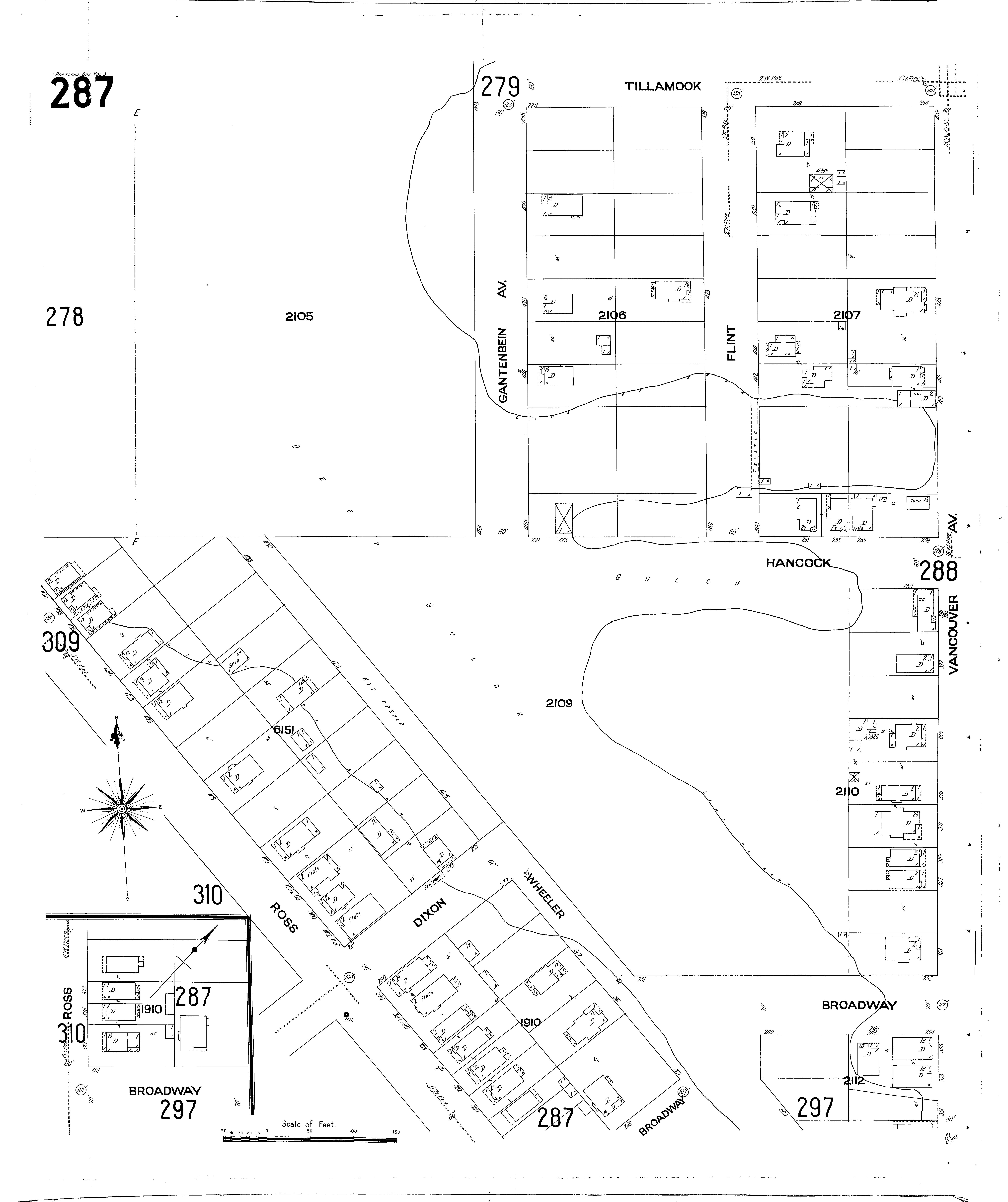
Here’s the area around today’s Portland Public Schools building off Dixon in Sanborn Plate 287 from Volume 3 in 1909. If you venture around this vicinity today as we did recently, you’ll see the line of bank hasn’t moved a whole lot, but the bottom of the gulch has clearly been filled. For a comprehensive discussion of the development of this area, check out Roy Roos’s excellent book The History of Albina.
img6

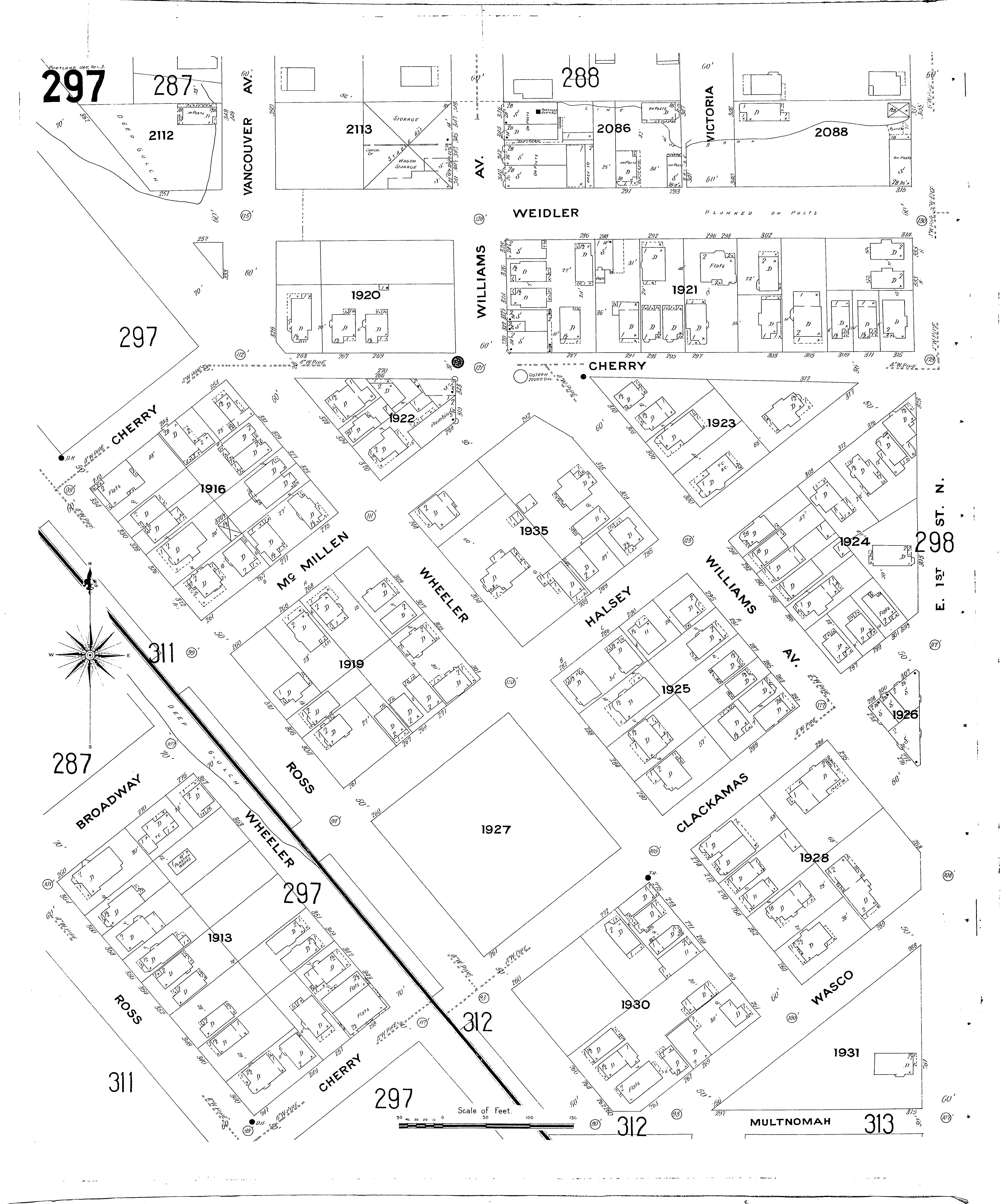
In Plate 297 above, you see a channel toward the bottom of the map at the “intersection” (we use this term loosely because these were little more than gravel traces, not engineered roads at the time) of Wheeler and Broadway, and an east-west hollow up toward the top all along Weidler, where Sanborn notes that either the street or future buildings, or both, were planned to be built on posts. Bring on the engineers!

Let’s hear from Edward W. Coles, who grew up on Hancock Street, one block from this terra incognita, at today’s 77 NE Hancock. Coles was an adventurous schoolboy at the turn of the last century. His explorations and memories are collected in a self-published volume called These Were My Days. In just over 90 pages, he brings Portland day-to-day life of the 1900s into very clear focus. It’s great reading: a time capsule, really, that we’ll draw on again down the line. Here he introduces us to one of the most memorable afternoons of his entire life, which happened in Montgomery Gulch at the foot of Hancock Street.

One of my most unusual experiences happened when I was in my early teens. Ecology was not a concern in those days. They threw most anything down the hill into Montgomery Gulch. [My friend] Orlo and I would go down after school looking for anything we could use. Once, there was a piece of galvanized pipe 2 feet in diameter and 15 feet long which was lying on the side of the hill. He dared me to slide down the inside.

I put both arms against my sides and slid down. The only trouble was that the lower end had dug in the dirt and I couldn’t get out. I hollered and Orlo tried to move the pipe but it was too heavy. Then he got frightened and left, leaving me stuck in the pipe. I thought he was going for help. I wondered what would happen to me: maybe I would starve or maybe the rats would crawl into the pipe when they saw I was helpless. I screamed but my voice only echoed against the pipe. I was frantic, and I was sure that my days were numbered.

In the meantime, Orlo went to his home. Eventually my mother called me for dinner. No Edward. She had all the neighbors hunting, but no luck. Orlo had never said anything to anybody; he was too frightened. They called the police, but no luck. Then, one lady said that she saw me with Orlo early in the afternoon and that Orlo must know something. Finally the policeman frightened Orlo so badly that he confessed where I was. By that time it was getting dusk, and four or five men went down to the Gulch and pulled me out. I had been in the pipe for over two hours; I was almost out of my mind. I never thought I would get out of there alive. I was in bed for two days and had nightmares for months.

About that time they decided to put Montgomery Gulch to some good use, for valuable industrial property. They used hydraulic mining equipment: a giant hose and nozzle and lots of water at high pressure. A drain was made to the Willamette River, but after several weeks they had dead carp. The odor was awful. However, they eventually got it all washed down and smooth, all near the railroad and the river.”

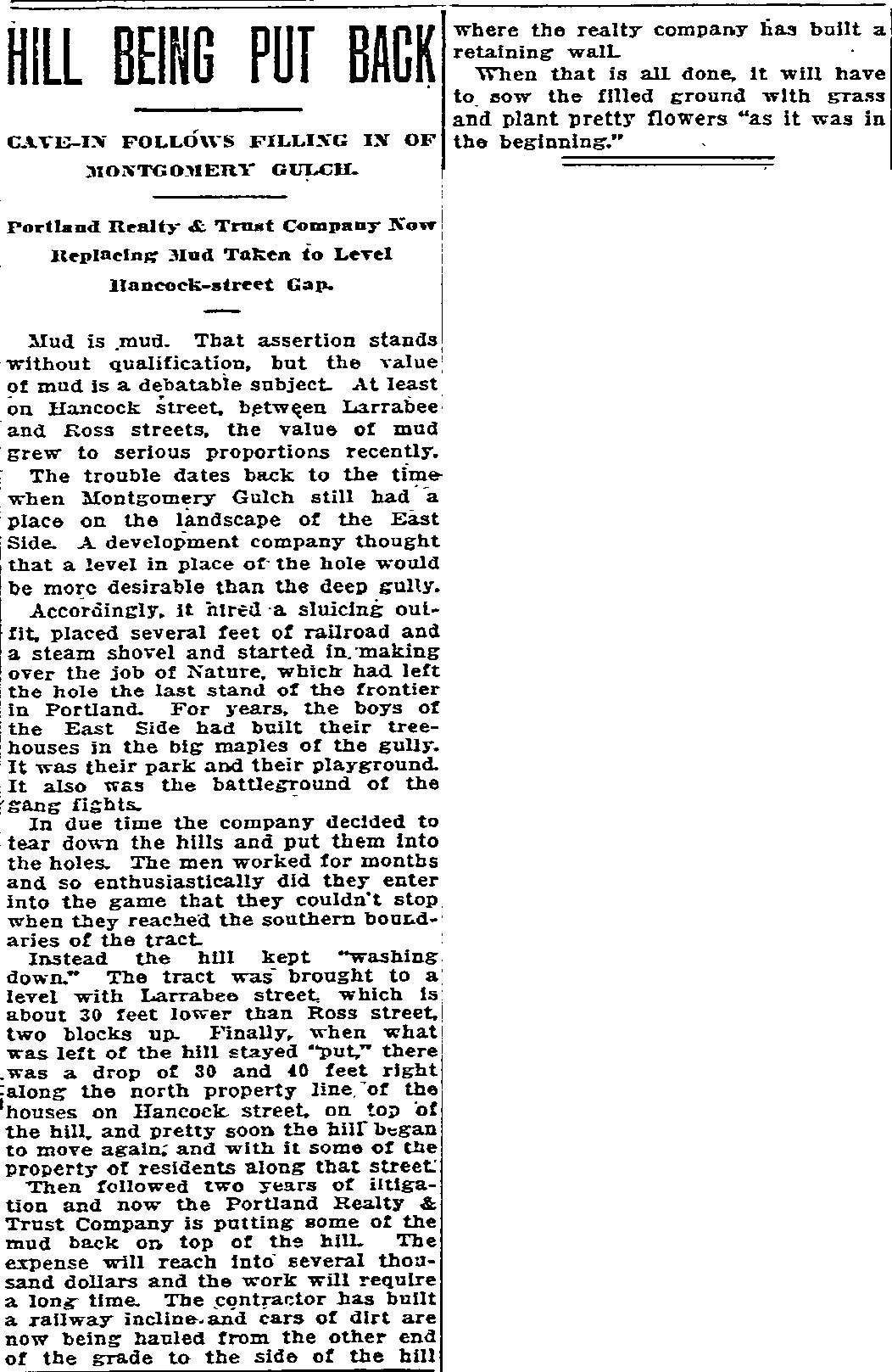
Montgomery Gulch was a geographic place–you can see it there in Sanborn 287–and it was perceived as a major impediment to development. Named for James B. Montgomery (1832-1900), a railroad and real estate business leader and Oregon legislator who was a force behind the development of Lower Albina. Here’s a story from The Oregonian on November 13, 1914 describing ongoing challenges with filling Montgomery Gulch (note the salute to young Coles and his playmates down in the third paragraph):
img6

While these rough places on the bluffs may have meant adventure (and a scary afternoon) for young Coles, real estate developers had bigger issues. For them, the transportation and infrastructure challenges meant property with less value, and obstacles for higher value properties they were trying to sell. Gulches elsewhere in Portland were being converted to sewers draining directly into the Willamette. Some were open garbage dumps. Others were bridged by long trestles for roadways or rails. Whatever the strategy, a growing Portland needed more flat land and was ready to do whatever it took to solve the gulch problem. Here’s a quote from The Oregonian on March 3, 1905 that summed up the sentiment of the day:

“Around Vancouver Avenue and Weidler and Victoria streets is a deep gulch that runs down from Irvington. Into the gulch is dumped debris of all kinds. A row of buildings backing upon the gulch are said to be without proper sewerage. Complaints and remonstrances to the authorities have availed naught, say the neighbors.”

And a letter to the editor from November 6, 1912:

“Why could not all the refuse be dumped in some deep gulch and then have a crew of men grading on the mountain side closeby and dumping their earth on the garbage? Earth will purify any putrefaction it comes in contact with. Signed, O. Hempstead”

To the question of differential property values of gulch vs. non-gulch—and who pays the cost of improving infrastructure—some developers wanted to put the entire cost only on those owners whose sloped property was in need of improvement. Many on the eastside argued to spread the cost across all owners who would benefit.

Ultimately, as Portland’s population grew and property values increased, the city figured out how to contract the substantial grading and fill work. Fill was brought in from elsewhere on the eastside, and the city undertook a major project of widening and lighting Northeast Broadway to coincide with opening of the Broadway Bridge on April 22, 1913. Here’s an article from June 30, 1912 about big changes to the gulches, the streetcar line, and to Broadway itself:

6-30-1912 Fills Planned

By the time the Broadway Bridge opened, most of the curbs and streets were in place up here in Alameda. Sewer lines were in and streetcar lines and local businesses were starting to bloom. The grid was in place, the gulches filled, and the first steps were taken on the uncertain path to the future.

NE 3rd and Broadway as you’ve never seen it

One of the great joys of our research is finding the unknown—more properly the long forgotten—in the midst of the known. Photos, memories, documents and stories from the past add new understanding to places we know (or think we know), and often bring a hint of the familiar: the profile of the ridgeline on the horizon, the curve of a street, the form of a building we recognize.

Sometimes these clues from the past are unreconcilable with the landscape we know today. In the world of Northeast Portland neighborhoods, pretty much anything after 1910 will carry a hint of the familiar. Turn back the clock a bit further and those hints are harder to detect.

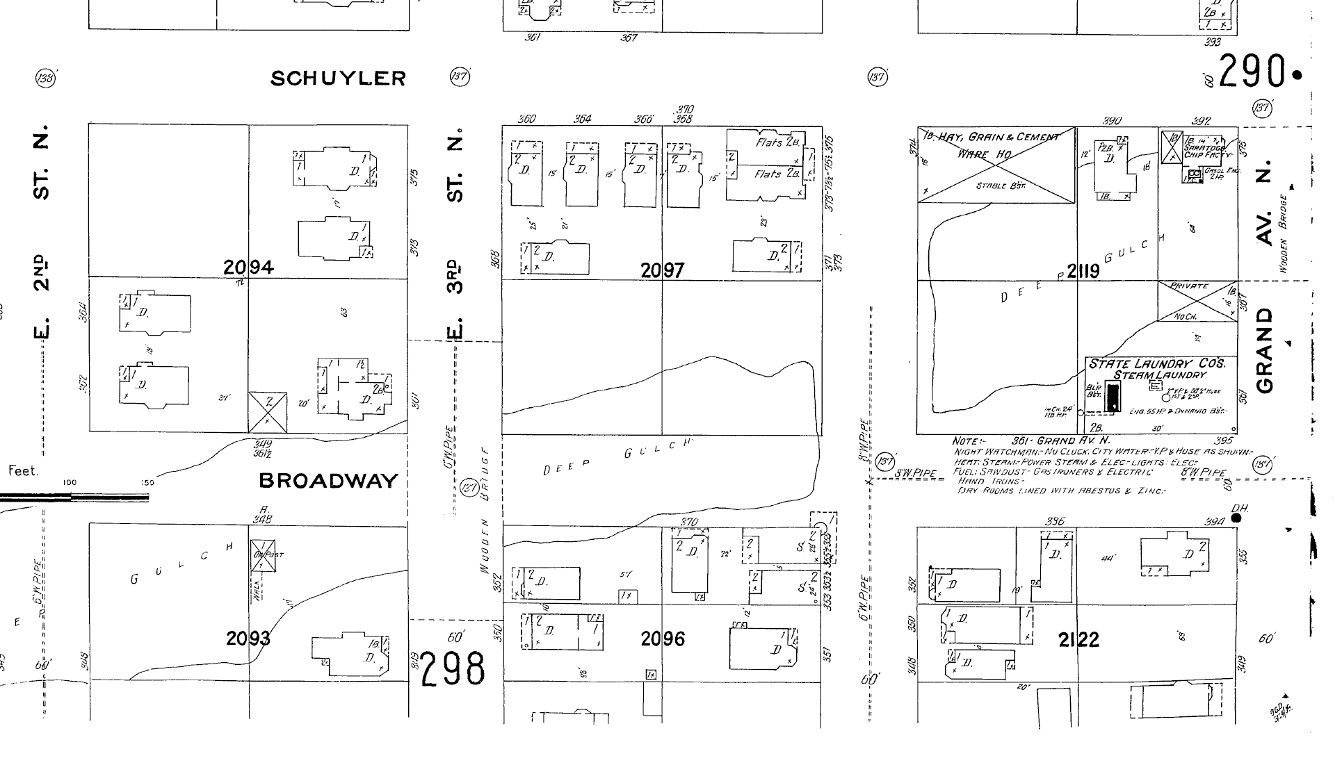
Case in point: this Sanborn fire insurance underwriting map from 1909 of the Eliot neighborhood, showing the vicinity of the busy intersection at Grand and Broadway that we all know. Or think we know. Have a good look and pay attention to the location and extent of the gully shown as Deep Gulch, the wooden bridges, the buildings up on posts, the row of houses with their bay windows all to the side. Check out the State Laundry Company building too, and the note about the night watchman. (If you don’t know about Sanborn maps—which were used for fire insurance underwriting—be sure to check out our post on the topic).

1-16-16 Sanborn 289 Detail

Detail from plate 289, Sanborn Fire Insurance Map, 1909

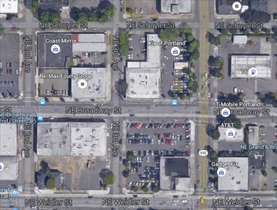
Everything in this frame from 1909 is absolutely gone today—the gully, the buildings even the streets which have been widened—and most of us speed through here (being careful about the red-light cameras) on our way somewhere else. Below is a modern view of that intersection.

1-16-16 Detail from Google Earth

Thanks to Google Maps. Click the thumbnail above for the full photo.

* * *

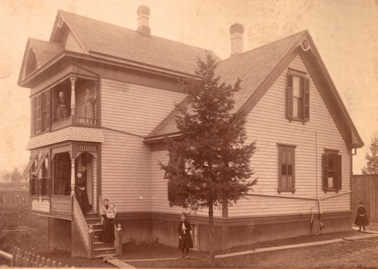
Ready for an even closer look? This is the fun part where we get to try to imagine the landscape that once was, and how different it is today. As you study this photo, be sure to check out the detail: the awning style shutters; the orderly clapboard and fish-scale siding; the beautiful shingle roof; the decorative round gable end ornaments; the family members at each level; the gulch out back. The picket fence in the left foreground is running north-south along the edge of NE 3rd. The double gable end faces NE 3rd, so this view is looking off to the south/southwest at the corner of NE 3rd and Broadway.

1-16-16 Soden Home 3rd and Broadway

Home of B.T. and Cora Soden, NE 3rd and Broadway. Photo courtesy of Bob Elston.

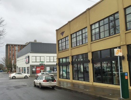
And an approximate view today:

Site of Soden Home, NE 3rd and Broadway, northwest corner

237 NE Broadway in January 2016.

We’re able to feed this imagination thanks to fourth-generation Northeast Portland resident Bob Elston, great-grandson of Bartholomew and Cora Soden, who recently shared these and other family photos that got us to wondering about this part of the neighborhood, and to haunting these blocks ourselves in order to take a good look. Thanks Bob.

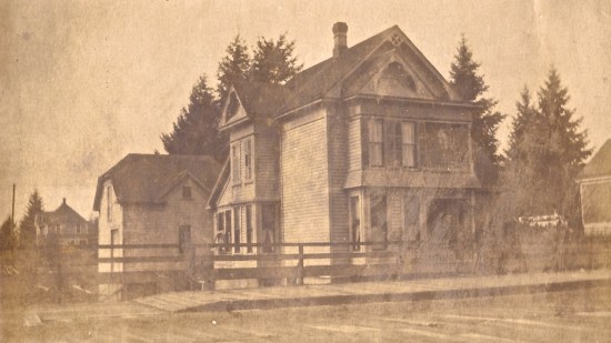
Fast forward a few years and a slightly different angle at the Soden place, this time looking west/northwest showing the barn out back, which is depicted in the 1905 Sanborn map. Note the same wooden bridge on Northeast 3rd over Deep Gulch, which keys the building into the northwest corner of that intersection. The dip of the gulch is still visible off to the left.

1-16-16 Soden Home 3rd and Broadway 1905

NE 3rd and Broadway, looking west in the late 1890s. Photo courtesy of Bob Elston.


Mildred, Willard, Frances, Raymond in front of the house on NE 3rd.

Frances, Willard, Mildred and Lester Soden, in front of the house on NE 3rd, 1898. This view is looking north on 3rd. Photo courtesy of Bob Elston.

* * *

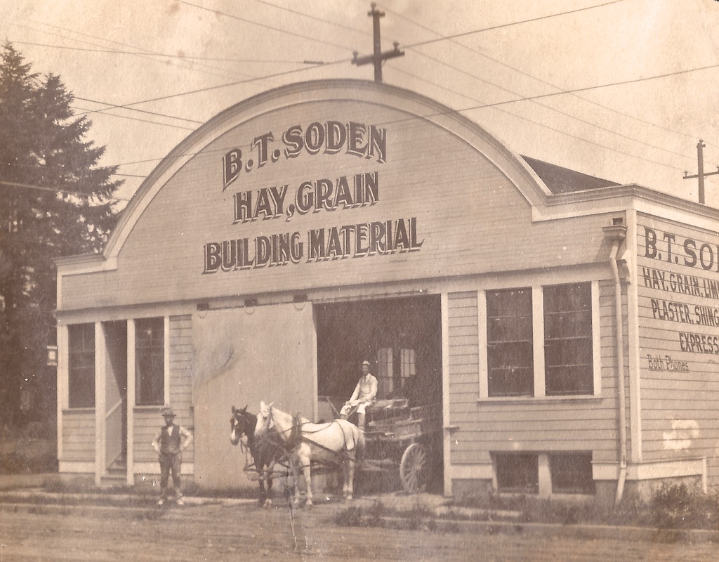
Bart Soden was owner and proprietor of B.T. Soden Hay, Grain, Coal and Plaster, provisioner of vital goods for the eastside at the turn of the last century. His warehouse and business was located just a block east from the family home at the southeast corner of Union and Schuyler (today’s MLK and Schuyler). Scroll back up to the Sanborn map and look at it there in the upper right corner, labeled “Hay, Grain and Cement Ware HO.” Here’s a picture of Bart and a helper, probably from about 1905, showing the delivery wagon heading out on a run:

1-16-16 BT Soden Business

The southeast corner of NE 3rd and Union, about 1905. Photo courtesy of Bob Elston.

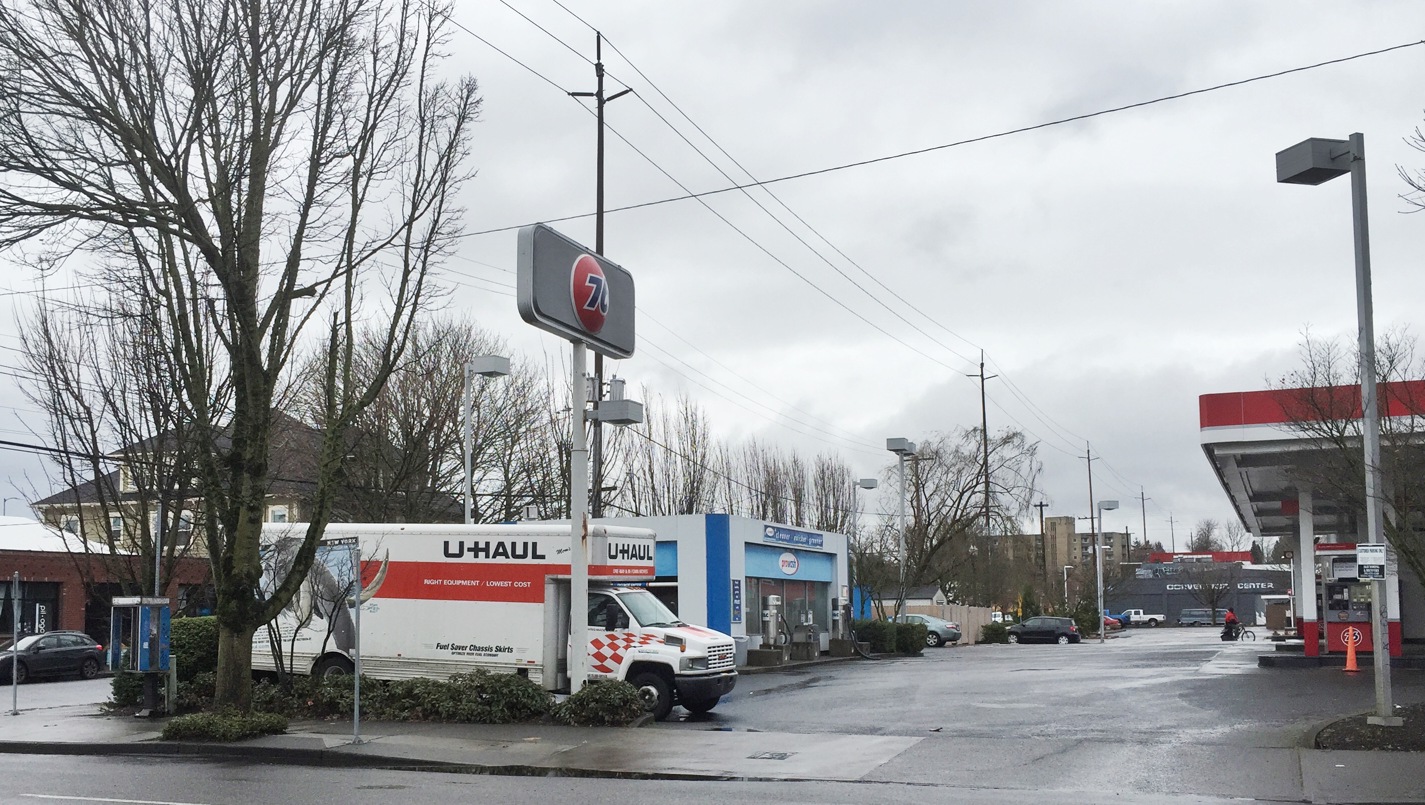
Here’s the same view today:

Site of Soden Business, MLK and Schulyer, southeast corner

Bart was born in Australia in 1849, came to Oregon as a young boy, and grew up in rural Polk County. He earned a degree from the Oregon Agricultural College in 1879, tried his hand at teaching for a while, and eventually moved to Portland in the 1880s where he married Cora Wells, 16 years his junior. The couple built the house and business we’ve been looking at here, raised a family of two sons and two daughters, and were active in Portland society. Bart died in 1926. Cora lived until 1950. Both parents and several of the children are buried in the family plot at Portland’s historic Lone Fir Cemetery.

We’ve recently come across a memoir by a Portlander who grew up a couple streets over about the same time as the young Sodens. Stay tuned for his observations, which will continue to help us bring this long lost landscape back to life.

A day in the life of Beaumont: June 1927

Here’s the final installment of Bessie Kramer’s Beaumont business district photos from the 1920s, and there’s so much to see. If you missed the earlier photos (including the great one of the houses at NE 40th and Failing), you can find them here and here.

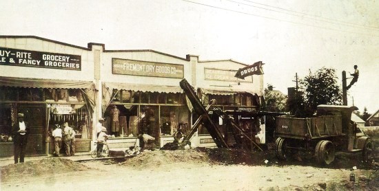
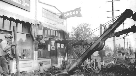
This last one looks a bit like a Norman Rockwell painting: There’s so much going on. The view is looking north at the corner of NE 42nd and Fremont. From these same footprints today, we’d be looking at the edge of Pizzicato on the far left, and then Americana Frame and Silhouette. The building housing Tuk-Tuk, formerly known as Watson’s O-So-Good Restaurant and Sandwich Shop, hadn’t been built yet in the vacant lot behind the lineman on the pole. As noted in the earlier series, we think this was a sewer repair requiring deep trenching in front of 4223 and 4225 NE Fremont.

Click on the photo to enlarge for a good look yourself and then come back here for our take on what we see.

1-3-16-kirkland-photo WORK


4223 and 4225 NE Fremont, taken in June 1927. Courtesy of Bessie Kramer and Paul Kirkland Collection.

The other photos showed a display of fireworks for sale in the pharmacy window on the far right, hidden here behind the excavator, making us think this was late June or early July. Another one, shot from a different angle, indicated that the “Dutch Village” building across the street that now houses Gazelle hadn’t been built yet, which means this view is prior to 1928. Fremont Dry Goods doesn’t show up in the city directory until 1927, so by process of elimination, that’s our guess: late June or July 1927.

A man in a suit coat and fedora, who we think we saw down in the trench in an earlier photo, is taking a break here. Three boys are having a good look in the window at Mr. and Mrs. Witt’s Buy-Rite Grocery (did they have a fireworks display window too?). Two more, still on their bikes, are having a good look down the hole. A worker breaks up concrete, and another is at the levers of the excavator. A lineman is working on one of the omnipresent power poles. Everyone in this picture has a hat on.

We believe Bessie Kramer started out as a saleswoman and clerk here at Fremont Dry Goods, the middle store with the dresses and fabric in the window. According to the city directory of 1929 (the year after the new building had been built just across the street), Fremont Dry Goods disappears from its location in this photo and Beaumont Dry Goods appears in the space across the street occupied today by Shop Adorn. Hypothesis: Bessie moved the business across the street. A generation of Beaumont kids remembered Mrs. Kramer’s dry good store there on the south side of Fremont. They probably had more vivid memories of Mrs. Cox’s Variety Store, which was really a candy store, strategically located due east across from Beaumont School in the long narrow space now occupied by Daruma Sushi + Sake. What a great place for a candy business: literally a stone’s throw from the classrooms.

This great series of photos allows us to give AH readers a nudge: we’re always looking for pictures that might be in the family attic or afloat in an old shoebox. Street scene, family pose on the front porch, kids at Wilshire or near a school. We’re interested. Most of these photos from Bessie Kramer were originally very small: less than two inches by three inches. We’re able to scan them carefully and return them to you safely.

An old house has soul

Happy New Year Alameda History readers. Yes, you’re in the right place.

We’re starting out 2016 with a new look, which you will have noticed. Most things are about in the same places you would expect to find them. We’re doing some tidying up after the move to our new format, so if you have a question or see something out of place, let us know. Almost all of our original content is now here on the premises.

We’ve spent some time with back issues of The Oregonian over the quiet week between Christmas and New Years and have turned up all kinds of interesting gems and an actual real insight or two. We’d like to share one of the gems here as a way of getting our new format and new year off on the right foot. We’re glad to be the one out of ten and bet you are too. Enjoy.

11-3-1929 Old houses have soul

From The Oregonian, November 3, 1929

Stay tuned for a new look!

In the life of an old house, we know it’s important to renovate, refine, upkeep and maintain or things start to fall apart, or at least not work so well. This week, as we’ve begun to make a few improvements to the look and function of Alameda Old House History, we have learned the blog design framework we’re using is no longer supported. Uh oh. We’ve also been thinking for some time that it might be nice to use more of the visual page here on screen, and to continue to broaden the community of interest in connecting past and present in old homes, buildings and neighborhoods.

So for 2016, a few changes. First, a fresh look that we’ll be rolling out in the next day or so. Nothing fancy, it’s in keeping with our overall tone and style and we think it’s an improvement. Some things will look familiar, all of our existing content will move over, and you’ll be able to find your way around. Stay tuned, and let us know what you think.

Second, we’ve linked the site to a Facebook presence.  One of our goals with the blog has always been to get more people appreciating and hooked on the history of their homes, neighborhoods and old buildings. Click the Facebook like button on the sidebar and share with your friends.

We’ll start the new year with a great piece we’ve found in The Oregonian from 1929 about the soul of an old house. You’ll like it. And then we’ll wrap up the Beaumont photo series with one last great photo before moving into a list of topics for the year ahead including demolitions, the Alameda stairs, more on local mom-and-pop stores, a bunch of then-and-now paired photos and others. Any suggestions or things you’d like to see here? Neighborhood history mysteries to explore? Old photos or documents we should see?

Thanks for being along with us on the history ride, and Happy New Year.

-Doug

Beaumont 1927 Construction Photo Series

Four more tantalizing views of the Beaumont corner at 42nd and Fremont from the late 1920s (we think June 1927), all showing some major trenching and dirt-moving activity out in front of the shops on the north side of the street. All four are from the collection of Beaumont Dry Goods shopkeeper Bessie Kramer and her grandson Paul Kirkland. If you need help orienting yourself, we’ve placed current companion views to each of these at the bottom of this post.

You’ll recall from our earlier posts that Bessie Kramer ran the Beaumont Dry Goods and Book Shelf store in the 1930s, which—based on Polk City Directory records—we believe started out life as Fremont Dry Goods in 1927 here on the north side of Fremont, about where today’s Americana Frame shop is now, and later moved with a name and ownership change to the south side, where Shop Adorn is today, when construction of that building was finished in the fall of 1928.

Incidentally, we’re mapping the comings and goings of Beaumont’s various businesses over the years, and doing some homework on the Beaumont Market/Gazelle commercial building on the south side of Fremont at 41st (which is actually two buildings built seven years apart) so stay tuned for that. If you have photos or insights to contribute on the general topic of Beaumont business over the years, we’d love to hear from you. In the meantime, have a good look at the images below which we believe were shot all about the same time (click on each one for a larger view), and when you’re done, come back here for some discussion.

Beaumont Construction 1

East view

Let’s start by orienting ourselves here. Look carefully at the address over the door of the shop to the left, which is Fremont Dry Goods, 1213 East Fremont Street North. You can’t quite see the business name in the upper left, but you’ll see it in the next photograph. It reads “Fremont Dry Goods.” After Portland’s Great Renumbering in 1931, that address became 4223 NE Fremont, today’s Americana Frame. Next door to the right, at today’s 4225 NE Fremont, is Fremont Pharmacy, home of ice cream, cigars, drugs and on this day lots of fireworks. The pharmacy business shown here, (which moved across the street in 1929 and became a neighborhood fixture in the shop occupied by today’s Gazelle) is known to us today as Silhouette, a tailoring shop. There is another business out of frame to the left–Buy Rite Grocery–but we’ll get to that in a moment. Click here to keep reading…

Then and Now | Criticize this house

A brief pause from the Beaumont photos here on AH to make a deep dive into back copies of The Oregonian and other research into several stories we’re working on, and to learn more about the early Beaumont business district. Interesting stuff, so stay tuned.

It’s always easy for us to lose ourselves in the serendipity of research, especially during the quiet days at the end of the year.

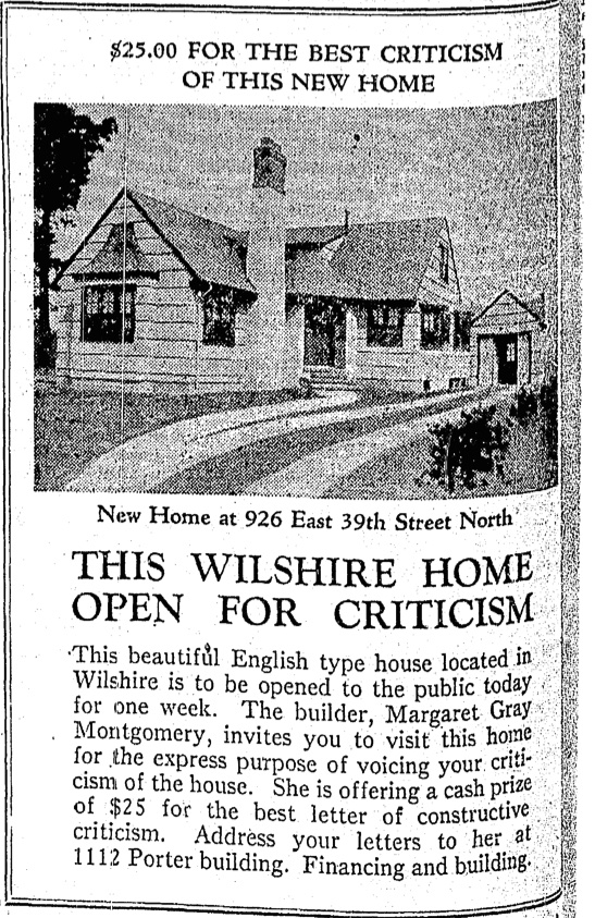
While looking for other things, we’ve come across some small gems. Here’s one from September 2, 1928: It’s either an interesting approach to real estate advertising, or a clever form of early market research, or both. It also makes for a good Then and Now. Check it out:

9-2-1928 House criticism ad (1)


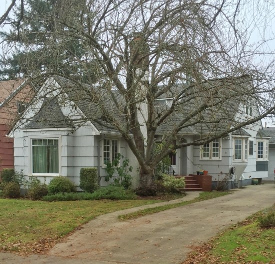
4404 NE Cesar Chavez Blvd

926 East 39th Street North is today’s 4404 NE Cesar E. Chavez Boulevard, in northeast Portland’s Wilshire neighborhood.

Margaret Gray Montgomery took out several other classified advertisements during this period, including one that advertised her office being located at 910 East 40th Street North (4324 NE 40th). A site office in addition to the Porter Building address? Curiously, Margaret Gray Montgomery didn’t appear in city directories as a builder or otherwise connected to the real estate business, wasn’t listed as owner of this or the 40th Street property in construction or city records, and was invisible to the federal census of 1930 and 1940. For what it’s worth, the 11th floor of the Porter building (see bottom of ad) was a hot spot for real estate and mortgage companies in the late 1920s.

As a postscript with a story to tell: a three-line classified ad in the March 30, 1931 The Oregonian, sandwiched between other ads about house foreclosures and repossessed furniture, reports:

Crawford Range for sale, also dining room rug and Hoover; will sacrifice, leaving city tomorrow evening. Also equity in beautiful home, 926 E. 39th N.

Hmm.

Turning back the clock in Beaumont: Photo No. 2

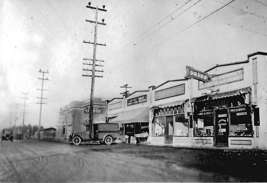
For our second installment in the Beaumont-Wilshire photo series, let’s take a look at a scene that will be simultaneously familiar and a bit exotic, at least to our modern eyes. There’s lots to look at here in this view to the west on Fremont from NE 42nd, so let’s just stare at this for a minute (click on the picture twice to open up a larger view) and then come back here to analyze what we can see.

42nd and Fremont, about 1929

NE 42nd and Fremont, looking west, about 1929. Photo courtesy of Paul Kirkland.

The first thing that jumps out are the powerlines: high tension, high elevation, lots of them and probably lots of power thrumming through to feed the new homes in the Beaumont-Wilshire neighborhood. Note the lines taking off to the left and right while the main feed runs east-west along the north side of Fremont. Good thing we’ve restrung these over the years. Poles are still there in what looks like the same places, just not quite as toweringly tall.

Back to the picture, look left of center and you’ll see the familiar form of today’s Beaumont Middle School, then known simply as Beaumont School, a fully-contained K-8. Built in 1926 by Stebinger Brothers general contractors at a total cost of $225,000 from a design by Portland school architect George Jones, the school was both hearth and namesake for the neighborhood, hosting generations of local kids. Look beyond the school to the left (west) and you can see one of the portable units that functioned as the first Beaumont School starting in 1915, and then after 1926 was the venue for Beaumont’s shop and “manual training” classes. Look carefully and you can see there were actually a couple of buildings there. Alameda School was based out of portable units in the early years as well: something that we’ve written about here on the blog. Check out these stories here and here.

Our photo shows a 1928 Ford Model A Truck in the mid-ground, backed up to four businesses located where Pizzicato, Americana Frame and Silhouette are today on the north side of Fremont at NE 42nd. These buildings were built in 1929 and are still standing today—with some significant modifications. The “Dutch Village” commercial block across the street on the southside, which houses today’s Beaumont Market, is not visible in this photo, but was built in 1929. More about that building and the commercial hustle and bustle of the neighborhood coming up in future posts.

The four businesses visible in this early photo are Beaumont Hardware (which has since moved east a block); Henry and Anna Witt’s Buy Rite Grocery; Fremont Dry Goods Company; and Beaumont Pharmacy (which later moved across the street to the southside where Gazelle is today, where it became a neighborhood fixture for its soda fountain among other things). Not visible in this picture but tucked into these spaces in the years that followed were John King, barber; Gustaf Pulos and Absolom Barnard Shoe Repair; and Charles E. Riggs, grocer.

Also visible is what looks like rough surfacing of Fremont. Looks like dirt or gravel to us in this picture. We know that paving was a premium in early Portland, but our research suggests this stretch of road had indeed been paved by then. The next several pictures will show some street and sidewalk work in front of these businesses—which may have been why the photos were taken in the first place—creating some paving and road surfacing needs.

Lastly, the arc and sweep of tire tracks in the lower left of this photo might suggest streetcar tracks to some. But just for clarity, that wasn’t the case. We’ll write about the Beaumont streetcar in a future post, but it didn’t pass through here: it came up Wisteria and NE 41st, stopping in the vicinity of Klickitat Street. Stay tuned for more on that.

Time travel’s kind of neat, eh? Thanks Paul. Wondering what this intersection will look like 100 years from now…

Next: A look at construction underway in the Beaumont business district.

Amazing early photos from the Beaumont neighborhood

If you’re a frequent AH visitor, you know we love old photographs, particularly when they include a house or building still around today, a vintage street scene that transports us back in time, or maybe a neighborhood mystery that needs solving.

Here’s an amazing photo you might think was taken in rural Oregon, maybe in the thick Douglas-fir forest up near Mt. Hood. Have a good look at the picture before you scroll down to see exactly where it’s from (click on the image for a very sharp and enlarged version).


40th and Failing looking Northwest

Ready for its actual location: Northeast 40th and Failing, looking northwest. Seriously.

Here’s the same view today.

Today 40th and Failing looking Northwest

This is the first of a series of photographs we’re going to roll out over the next few posts, showing the very early days of the Beaumont-Wilshire neighborhood, dating back to the 1920s. Life-long resident Paul Kirkland sought us out after learning of our passion for old photos and wanted to make sure his photos had a good digital home and were appreciated. Thank you Paul, and no problem there. We were thrilled to see these photos, which are about as close as possible to time travel.

The common denominator in these images that we’ll roll out in the next few weeks is Paul’s grandmother, Bessie Kramer, who lived in the neighborhood and ran Beaumont Dry Goods and Book Shelf store at the corner of NE 43rd and Fremont.

Bessie Bartos Kramer Weber was born in Iowa in 1894 and first appears in the Oregon record in the 1920 federal census with her husband Jessie and infant daughter Maxine. In the 1920s and 1930s, she lived in the neighborhood in several locations both as a boarder and then a renter.

Grandson Paul says that when this picture was taken, probably in the mid-1920s, Bessie and her husband Jessie Kramer were living in the small hip-roofed house on the left (which we think has been added to over time and is today’s 3829 NE Failing). The house on the right, which has recently been on the market, is 3905 NE 40th, built in 1922.

Stay tuned: some amazing pictures of Bessie’s Beaumont business at NE 43rd and Fremont are next, which will provide the basis for some good discussion about the early Beaumont business district.

Thanks Paul!

Portland’s Great Renumbering, 1931-1933: Bringing order out of chaos

Throw together a couple dozen scattered and growing neighborhoods, at least five incorporated towns with their own municipal governments, a public transportation system owned and operated by a handful of different authorities and private companies, a real estate market on fire, and an expanding network of streets and main arterials running across the whole complicated map. Sounds like an administrative headache, doesn’t it?

That was the challenge facing local leaders in 1931 when Portland decided it needed a new addressing system. The old way just wasn’t working: letters, visitors, homebuyers and even deliverymen were getting lost.

By the mid 1920s, Portland’s east side neighborhoods were booming. Research we’ve done into building permit history shows Alameda’s heyday of construction was 1922. In those early years, some homes started out with one address, but had to be renumbered—some several times—as lots were developed and new homes built.

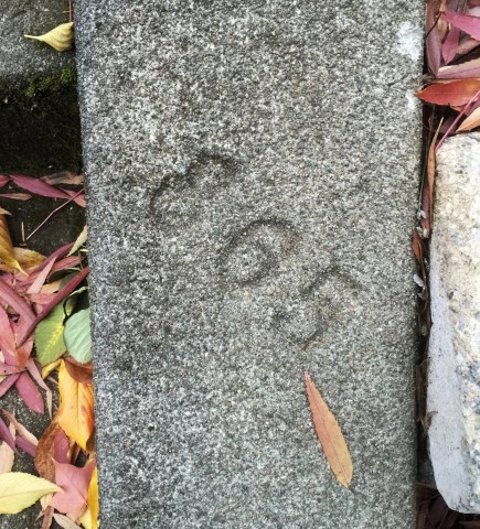
A remnant of Portland's early addressing system

If you look carefully when out walking, you might find clues to our old address system. This artifact was cast into a neighbor’s front steps when the street was East 30th Street North.

By 1926, the city engineer recognized the need to change our address system. Except for the alphabet district in northwest Portland, where streets were (and still are) alphabetical, there was no numerical or organizational logic about how we told each other where we lived or worked. No baseline starting point for address numbers like today’s use of the Willamette River and Burnside. No predictable and sequential set of numbers that go with each block (i.e. the 2400 block of any particular street being 24 blocks north or south of anywhere else). No primary districts (northeast, northwest, north, southwest and southeast). Just cardinal directions and a pack of numbers. By the late 1920s, Portland Postmaster John M. Jones reported that 2,000 pieces of mail were going astray each day because of the confusing and random addressing system.

After all, the fraying system in place had been cobbled together in the early 1890s when the cities of Portland, East Portland and Albina merged. In the intervening years, both the population and the territory of the city more than doubled.

Reflecting on our system’s need for help, one reporter for The Oregonian wrote: “Many a city planner and civic engineer had thrown up his hands or uttered oracular warnings at the antiquated way in which our city was numbered.”

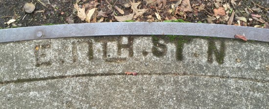
FullSizeRender (5)

More evidence of Portland’s early addressing system when all east side streets had two cardinal directions. Most of these early cast-in-place curb identifiers have been lost to modernizing curb cuts. Another name frequently cast into our sidewalks is builder Elwood Wiles. Click here for a photo and short biography of Mr. Wiles.

City Commissioner Asbury Lincoln (A.L.) Barbur recognized the problem and assembled a group to look at other cities for examples and to assemble a system that fit Portland’s needs. Barbur, whose name you will recognize from the southwest Portland boulevard named to honor him, was one of Portland’s most civic-minded early leaders. Elected five times to two-year terms as city auditor between 1907-1917, Barbur ran successfully in 1920 for commissioner (his election slogan was “Let the People Rule”). Read the reporting from the day and you’ll find him a pragmatic, smart, get-it-done elected leader who was almost single-handedly responsible for the business model that resulted in the paving of Portland streets, as well as the push to change the address system. Barbur’s street paving model is worthy of its own story: with so many new gravel streets in need of work, Barbur led the city to buy and operate its own paving plant rather than contract it all out, which saved the city millions of dollars, got the job done, and attracted the ire of local contractors who branded him a socialist.

In early 1930, Barbur’s addressing committee looked first at the system in Philadelphia, and then at Milwaukee, Wisconsin for ideas. As they did their scoping work, they also held public meetings in Portland neighborhoods to hear ideas and build support. By December 1930, Barbur’s committee had crafted a plan and received unanimous support from 18 different community organizations.

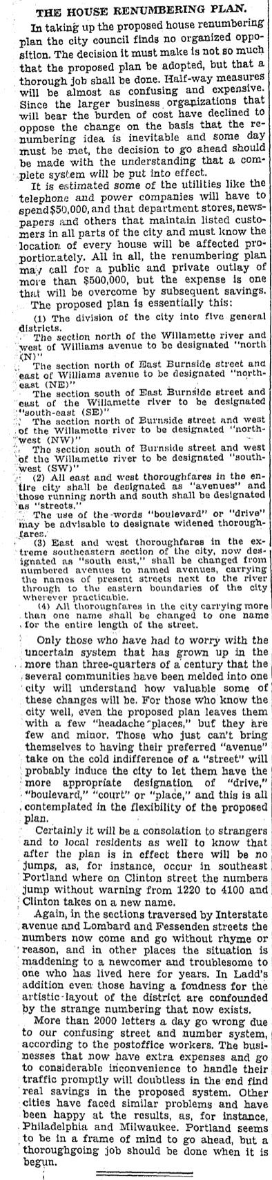
The essential framework was the system we know today: Divide the city into five sectors: NE, NW, SE, SW and North (owing to the bend in the river). Burnside was to be the new baseline north and south; the river was already an effective east-west baseline. Blocks would be divided into sets of 100 numbers. And some substantial renaming would add continuity and order. Here’s an editorial from The Oregonian on May 13, 1931 that endorses specifics of the plan and makes the case for change.

5-13-1931 Editorial


On September 2, 1931, city council unanimously and enthusiastically passed the plan, including $10,000 to pay for ceramic number tiles for every house and building, and it created a workforce of unemployed men to get the job done. Here in Alameda, renumbering and renaming resulted in a numeric transformation, and the changing of at least two street names, Glenn became NE 32nd Place; Laura Avenue became Edgehill.

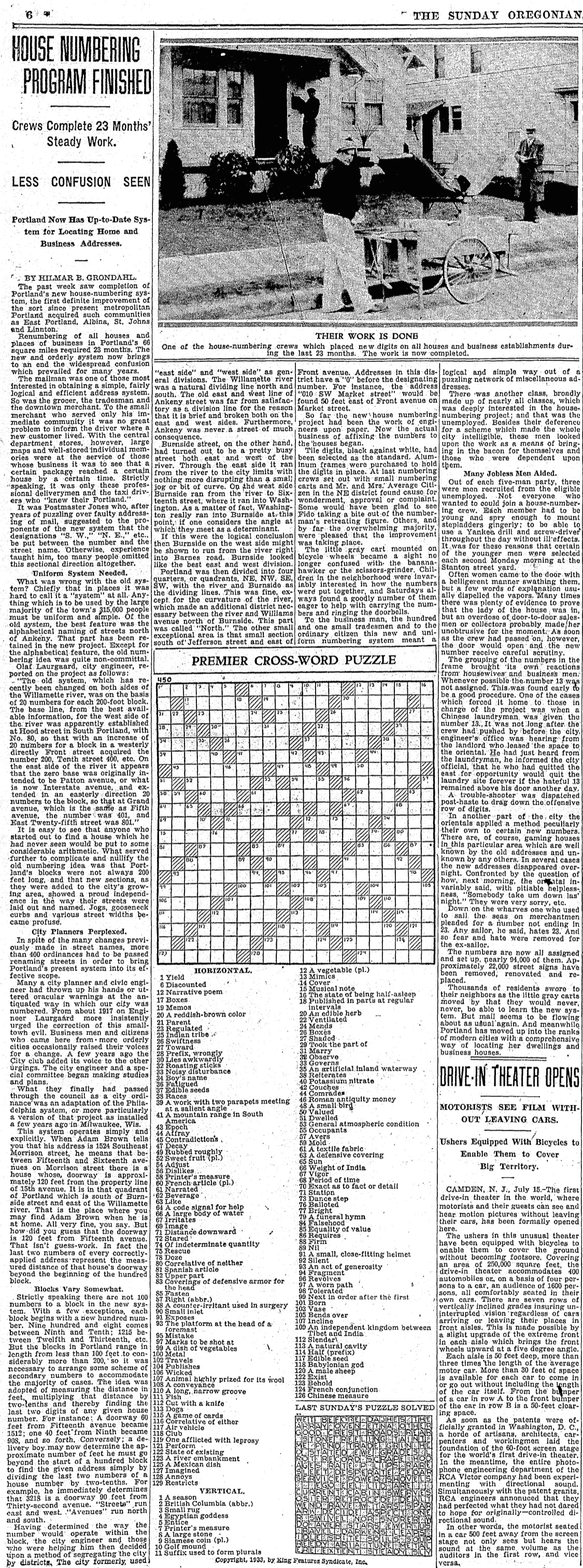
Work is done photo

From the July 16, 1933 edition of The Oregonian. Click on the image to read the full story.

From the fall of 1931 through the summer of 1933, crews of workers fanned out across 66 square miles of Portland pulling wheeled carts filled with ceramic numbers, aluminum trays to hold the numbers, and hammers and nails to anchor them to every Portland house or business. It took 23 months. Not everyone was happy: some were superstitious if assigned anything with a 13 in it. Others who operated certain established and illegal businesses out of their homes took down the new numbers so as to not confuse their loyal customers. But most Portlanders embraced the new system and caught on to its logic quickly.

A ringing endorsement from The Oregonian on July 16, 1933, coinciding with completion of the renumbering, summed up how the community responded to the transformation:

“To the business man, the hundred and one small tradesmen and to the ordinary citizen, this new and uniform numbering system meant a logical and simple way out of a puzzling network of miscellaneous addresses.”


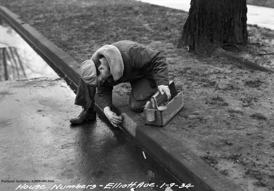
1934_curb-numbering-se-elliott-ave_a2009-009-31661

Painting a new address on the curb in Portland’s Eliot neighborhood following the Great Renumbering. Photo courtesy of City of Portland Archives.