Wistaria Drive landmark for sale

It’s always been a visual landmark on NE Wistaria Drive: the 1928 turreted English Tudor style house that anchors the big downhill bend at the confluence of Wistaria, NE 41st and Cedar Chavez Boulevard. The tower with its tip-top weather vane, 360-degree windows and tent-like roof dormers. The prominent gable ends and half-timbering. The brick, decorated entry way.

They don’t build them like this anymore.

For more than 30 years, we’ve walked by and felt the cry for help from the house and its former owner—who passed away in August—as the weeds took over, the windows cracked, the porch sagged and garbage piled up.

Neighbors are paying extra attention this week because the Wistaria turret house is now for sale. Many are hoping for a capable, patient, history-focused buyer who can bring it back to life.

We walked through this week to take a measure of how much work there is to be done. It is a major fixer-upper. All the building systems will need to be replaced and upgraded: electrical, plumbing, heating and ventilation; new kitchen, new roof. Every surface, finish, floor and window needs TLC. The foundation needs attention too, perched as it is on the slope of the ridge. Don’t forget the landscaping.

While the amount of work to be done is staggering, so is the grace and beauty of the original construction and the uniqueness of so many of the home’s interior spaces. There’s nothing else quite like the top turret room.

Check out this view of the house from April 1935, showing original owner Anna Hummel watering the garden (photo courtesy Portland City Archives AP/25295) and today.

3880 NE Wistaria Drive is listed by Cee Webster with Neighbors Realty. Cee has a deep appreciation for the character of the house and the reality of the work at hand, and has shared photos which you can find here. Cee will be accepting offers until December 8th at 9:00 a.m

In some ways, the complexity of the house mirrors the story of its earliest years. Built in 1928 by Jens Olsen for German immigrant Carl Hummel and his American wife Anna, the house embodies design aspects from Carl’s growing up years in Reutlingen, Germany.

Carl was a tailor. He and Anna arrived in Portland from Quincy, Illinois in 1907, and operated a tailoring, cleaning and dye business at NE 22nd and Sandy.

In the mid 1930s when trouble was brewing in Germany, Carl, then in his 60s, wanted to be back in his homeland. Working through an intermediary here in Portland, Carl arranged an exchange of homes and businesses with a Jewish German family who were trying to flee to the U.S. but had been blocked by the German government. Correspondence, telegrams and other documents archived by the United States Holocaust Memorial Museum convey the complexity of the exchange.

The situation for the fleeing German family was becoming dire; time was running out. The back-and-forth correspondence is steeped with anxiety and barely-contained impatience, but also with respect. If the families could organize a trade, neither would need to send money across international borders, which was forbidden.

Finally, in November 1936 with an agreement in place and papers approved, Carl and Anna moved home to Germany. Not long afterward, the very relieved Lowen family from Görlitz arrived in Portland as the new homeowners of the turret house on Wistaria. They became naturalized citizens and lived in the house for more than 30 years.

We’ll explore this story—and the unfolding next chapter of the turret house—in future posts.

Beaumont History Program: April 1, 2025

The Beaumont-Wilshire Neighborhood Association is inviting you to an evening presentation about the history and development of this northeast Portland neighborhood: Tuesday, April 1st at 7:00 pm. It’s free and pre-registration is required, which you can do here.

During our 90 minutes together, we’ll have a look back at photos, maps, newspaper articles and memories to create an understanding of the early days of the neighborhood as we look for connections between past and present. We’ll also examine the early forces that shaped Portland’s eastside and the excitement and boosterism associated with Beaumont subdivision’s big opening 115 years ago this month.

Searching for the 1920s Alameda woodcutter

A few years back, about this time of the year, we found a story in The Oregonian from the fall of 1921 that caught our attention. It was about a so-called hermit, a woodcutter who had lived much of his life in a one-room shack near Bryce Street, before Bryce was even a street and before the neighborhoods were built.

The newspaper story was trying to be one of novelty, but underneath it was actually a story of displacement. O’Donaghue was being moved on from the shack in the woods where he lived because land was being cleared and houses built.

Joseph Albert O’Donaghue told of helping clear forests to make the roads we know today, and of wolves and bears he’d killed right here on Alameda Ridge.

Some of it sounded a little fantastical. Like his memories of being a rifleman in the Crimean war 70 years earlier. Of being at least 90 years old. Of walking from Portland to San Francisco and back again.

But a bunch of it had a ring of truth and carried enough information that 100 years later, we could do a little diligence on his stories.

So before we apply some research tools to Mr. O’Donaghue’s story, read the piece below that ran in The Oregonian back on September 18, 1921. And if you want to get in the right frame of mind, you might also read our post Time Passes In Alameda from December 30, 2010, reminding us of so many layers of history here in these neighborhoods.

A careful read of the 1921 story helps us identify certain things to fuel our inquiry:

  • Researchers like a name like Joseph Albert O’Donaghue. Distinctive and traceable.
  • He was from Pictou, Nova Scotia, Canada.
  • He worked for Bernard Brandenburg, and his Bryce Street shack was on property Brandenburg owned.
  • He knew P.O. Collier (who offered him a new place to live).
  • He was a Mason.
  • He was a firewood cutter.
  • He had family in San Francisco.
  • He was a reader.

That’s enough to get us going. Here’s what we found:

The 1910 federal census shows O’Donaghue at age 67, single, living as a “hired man” with two other boarders and a cook in an unaddressed building near 37th and Fremont. It lists his birth year as 1843, from Canada, his father from Ireland, mother from Scotland, and that he arrived in the US in 1878. He reported himself as working full time as a farm laborer. We couldn’t find him in the 1920 census.

The annual Polk city directories track O’Donaghue’s presence like this:

  • 1888 listed as a laborer, boarding somewhere in East Portland (that was us before we became part of Portland proper in 1891).
  • 1906 listed as a laborer, boarding near Fremont and 36th.
  • 1916-1917 listed as a laborer, living near NE 35th and The Alameda.
  • 1921 still working as a laborer, living near NE 35th and Fremont.

His trail goes cold after the 1921 newspaper story, no city directory listings. Nothing. Then in March 1927, a death notice in Esson, British Columbia for Joseph A. O’Donaghue, age 80. Is this our man? Hard to know.

So to the next question: where was O’Donaghue’s shack? We know the property where he lived was owned by Bernard Brandenburg, who owned quite a few lots in the Spring Valley Addition, east of NE 33rd.

Spring Valley is one of the oldest plats in the area, filed on November 6, 1882 by “Clara L. Files, Spinster,” and encompassing the area east-west between 33rd and 37th and north-south between Skidmore and Bryce, including today’s Wilshire Park.

Brandenburg owned six lots which today make up the north end of the two blocks just south of Shaver between NE 33rd and 35th (when 33rd was the only road out here, the numbered streets in this vicinity didn’t exist). We’ve circled them below in red. If he lived on property Brandenburg owned, we’d guess that could be the location of O’Donaghue’s old shack.

Here’s a look at the 1925 aerial photo, with the Spring Valley Addition circled in red. Was the shack somewhere out there?

1925 aerial photo over the Spring Valley Addition. Bryce is incorrectly labeled as Beech. The dense stand of trees is today’s Wilshire Park. Aerial photo courtesy of City of Portland Archives.

Perry O. Collier was a popular and successful local real estate salesman who worked these properties as they came on the market. He may have been the one who handled the Spring Valley property deal with John L. Hartman, the big-time Portland attorney-banker-developer behind Rose City Park and other major subdivisions. Hartman bought the Spring Valley Addition property and replatted it for subdivision in June 1921. Those plans are probably what was leading to O’Donaghue’s ouster in September 1921.

This is where the story might bump into something we already know.

Not long after starting the blog—way back in 2007—we met three of the “boys” who grew up in this part of the neighborhood in the 1930s and 1940s. As often happens, our conversations led to questions, maps in hand, that would help turn back the clock. The boys told us about an old man who lived in this area, and we wrote about it in the post Memory Fragments | An old man and his dog, and a follow-up post Memory Map, which featured handwritten notes made on an old Sanborn map from one of the boys—Dick Taylor—about that exact property…that it was owned by the old man’s family. Hmm.

Is this our man? We’ll never know.

But the trip back in time is enough to reset our mental picture of the neighborhood we think we know today, and to feed our imagination. Think about that the next time you’re out on an evening stroll up Bryce on a cold night at the end of the year.

Beaumont Corner, 1928

Photo friend Norm Gholston has shared another view of a favorite corner, this one shows something important that’s missing, which gives us a good clue about when it was taken. Do you see it (or rather not see it)? Have a good look.

NE 41st and Fremont Avenue, looking southeast, about 1929. Photo courtesy of Norm Gholston Collection.

What’s missing is the Beaumont Market, which exists today immediately adjacent to the far left of this building. Here’s a post we wrote last year that includes a similar but slightly later photo, and beautiful color-pencil renderings of the market building (which came along seven years after the pharmacy), submitted to the city in 1935 by architect Charles Ertz.

Other things to note in this photograph include the absence of the McMarr Stores sign, which was present in the 1929 photo. Our hunch is that this photo was taken soon after construction–late 1928 or very early 1929–and used by J. Benjamin Lowe, Proprietor to get the word out about his new pharmacy, and his phone number. Note the Beaumont exchange was GA (someone trying to phone Proprietor Lowe would pick up the phone and say to the operator, “please ring Garfield 1614”). Do you know about old phone exchanges? Read more here.

The hinged box sitting on the curb: in more snowy climates, a box like this might hold gravel or sand for when the crosswalk and intersection become hard-packed and slippery, but Portland? Maybe. A drop box to keep the bundle of early-morning newspapers dry until the owner opened up? Other ideas?

The Barnes Mansion: Beaumont’s Century Old Family Compound

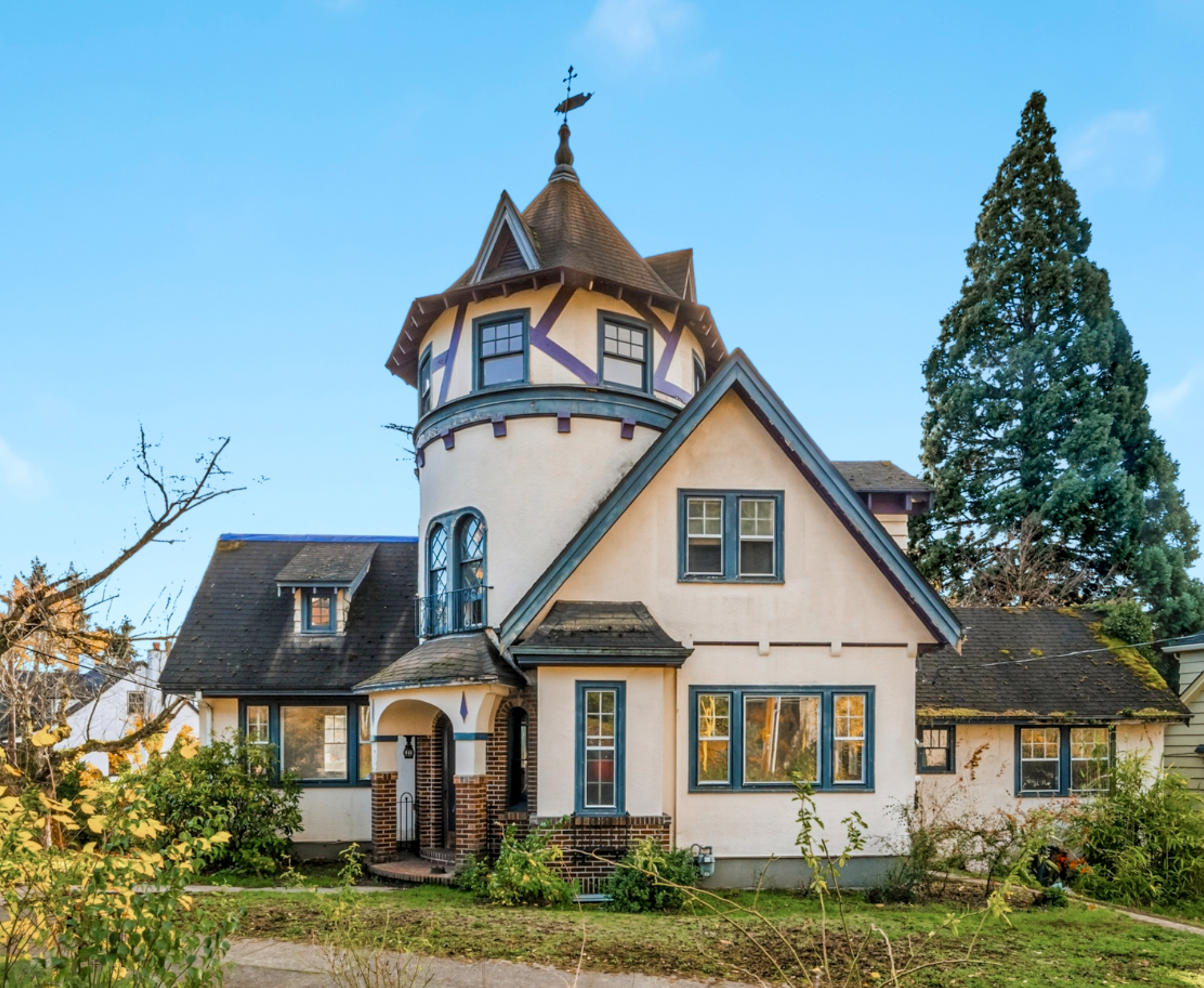
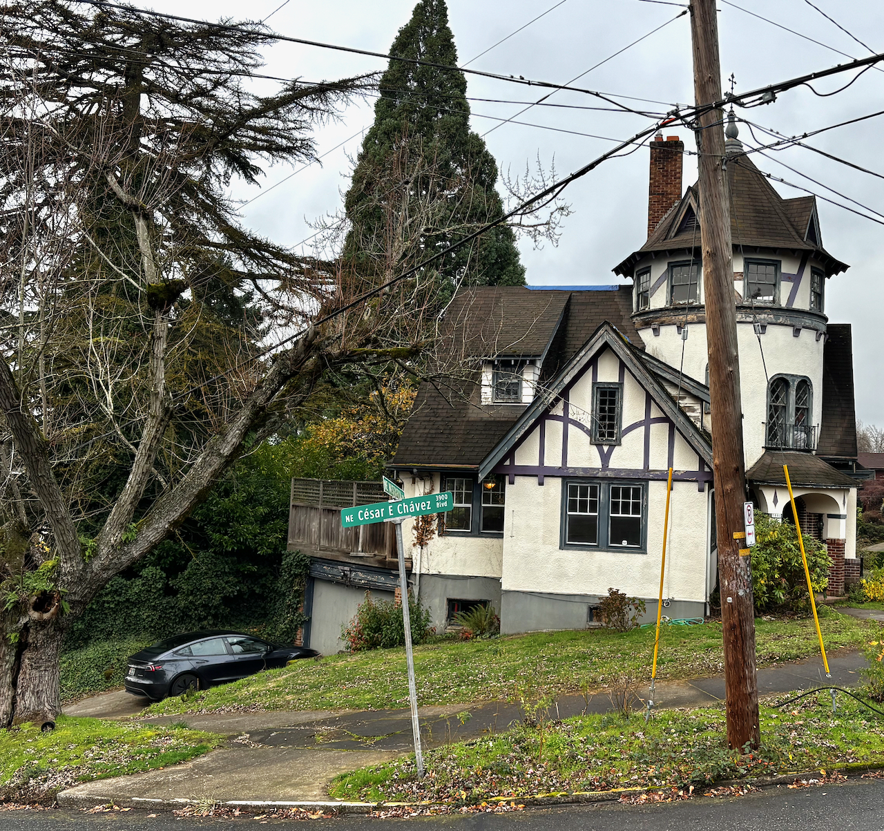
We’ve had an opportunity recently to delve into the history of a Northeast Portland landmark home: the 106-year-old Barnes Mansion at 3533 N.E. Klickitat named for Isabelle Payne Barnes and Frank Charles Barnes, the visionary and driving forces behind this building and its surroundings.

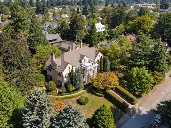
The Barnes Mansion in 2020, 3533 NE Klickitat. Several of the houses in this photo were built by and for one family.

The story of this almost 12,000-square foot, 32-room giant is about more than just a house though, it’s the story of one family and an entire neighborhood established for its children.

We’ll begin with Barnes family history for a frame of reference to understand the magnitude of the initial vision. And here’s a clue to that: It’s big. Frank Barnes operated in big brush strokes in business, in family and in life.

Frank’s professional life was all about food: growing, raising and making it; packing it; distributing it; selling it. And in later years, his fortune came from investments and real estate. Together, Frank and Isabelle built a business, a family and a family compound that came to define the western edge of today’s Beaumont neighborhood.

Early Years

Frank’s story begins on the Oregon Trail. Born in Albany, New York in 1854, Barnes spent the first years of his life on the family farm in Clark County, Iowa. In 1858 his family—parents William and Elizabeth Barnes—set out with an ox-drawn wagon along the Oregon Trail, eventually making it to the Willamette Valley.

Isabelle Payne was born in 1857, daughter of a homestead-era farming and dairying family that lived along Columbia Slough.

In 1858 when four-year-old Frank Barnes and his family arrived, Portland was a small town with limited roads and commerce. Soon after arriving, William Barnes launched into the lumber and milling business and quickly found success in any business depended on transportation. He was elected Road Supervisor and opened the route known today as Barnes Road, connecting Portland with the Tualatin Valley.

With commerce connected by new roads, the Barnes family moved into the grocery business. Think of it as an early farm-to-table establishment where father and son—William and Frank—bought and sold produce from eastside and westside to a growing population, including lands they owned and farmed themselves.

In 1876 Frank and Isabelle were married and the couple began their own family. Isabelle took care of home and family and was clearly the center of the universe for the couple’s children and grandchildren.

Frank Barnes builds a food business

As a young man building on the family business, Frank Barnes established Portland’s earliest and busiest grocery market at the corner of SW 3rd and Morrison downtown. It was an integrated business with 40 employees, seven wagons, farming acreage, a poultry farm, a fruit packing plant, a commercial ice and cold storage facility, and a huge warehouse for salting, smoking and canning salmon.

Every Portlander knew Barnes Market and Packing, and most had done business with Frank in one way or another. It was the place to go for delectable items: check it out:

From The Oregonian, November 25, 1900

Over the years, Frank’s success and the influence of his businesses propelled him into public office, serving multiple terms as Multnomah County Commissioner, a state legislator, a roads commissioner like his father, and even as police commissioner. With accumulated wealth and influence, Barnes began to invest in real estate. On the home front, the children were becoming like a big company of their own.

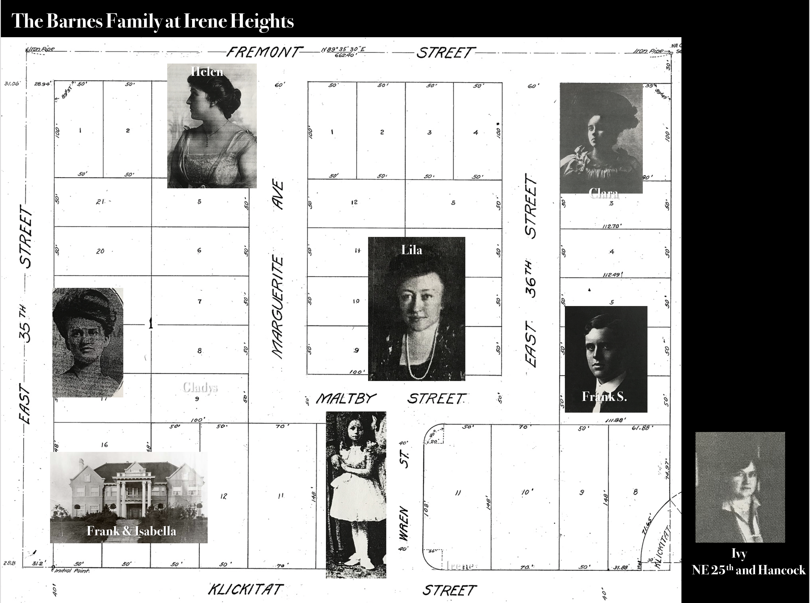
In the 20 years between 1875 and 1898, Isabelle had seven children: Clara; Lila; Ivy; Gladys; Frank; Helen; and Irene. Six daughters and one son. It’s important to have this in mind as we contemplate how this place came to be. As the kids grew, they married and each took on different aspects of the family business.

Given Frank’s desire to think big, what was the logical progression? How about development of a family headquarters—a kind of sanctuary, shrine and safe haven—done in a way that extended both the reach of the community and the family businesses.

These were the drivers behind what happened next.

A family compound takes shape on the eastern city limits

Barnes lived the example of anticipating the place where opportunity would exist and then getting there before others. As John Jacob Astor wrote: “Buy on the fringe of a growing city and wait.” Which is exactly what Barnes did. He and Isabelle had earlier bought a piece of the prominent ridgeline on the eastside known as Gravelly Hill. And in 1911, it was time to merge the vision for a family compound with the family real estate development business. He was 58 years old and Isabelle was 55.

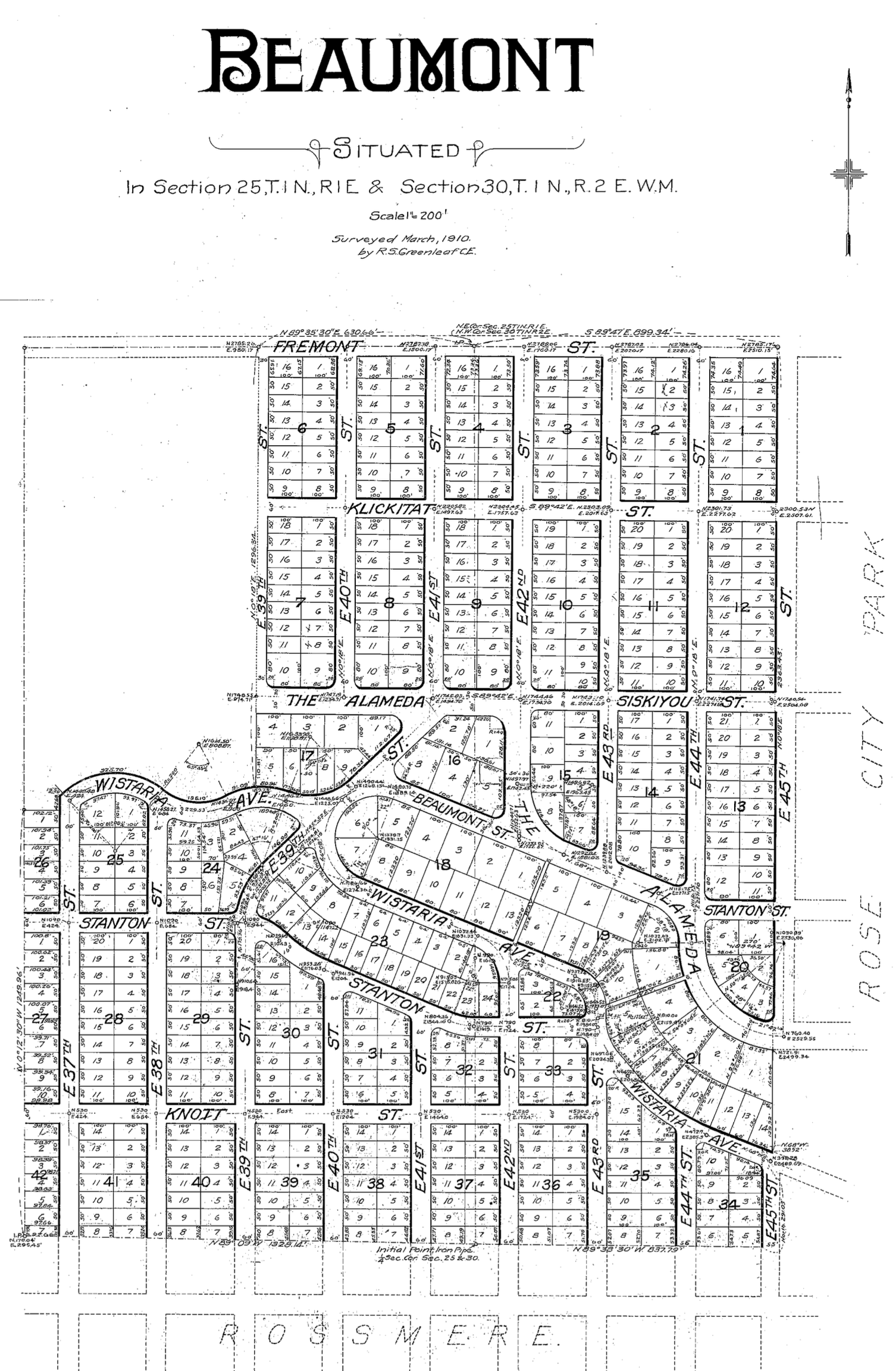
Here’s the official plat of what they had in mind: three square blocks between Fremont and Klickitat, 35th and 37th. 10 acres. They named the plat for their youngest daughter: little Ruth Irene.

Irene Heights Plat, 1911

First and foremost, this was to be a family bastion. Barnes carved out a property in the plat for each child all clustered around a main residence—like a central castle—which is what neighborhood kids in the 1920s called the big house: the Barnes Castle.

Remember, this was a sparsely populated area with dirt roads during the early years. The house was on its own septic system until sewers arrived in 1915. But the remote location didn’t hold Barnes back. He and business partner E.E. Merges owned this part of the forested slope. Their friends E.Z. Ferguson, Harry Hamblet, William Dunckley and John Bryce, with the Alameda Land Company, owned the slope just to the west. And in 1909-1911 everybody saw opportunity and acted on it with their own plats.

Back to Irene Heights…with the table set on the Barnes family acreage, construction started on the houses. First to be built in 1912 was the home for Gladys and her husband John J. Reynolds (who worked for Frank) to the north of the mansion at 3425 NE 35th Place, which has since been torn down.

Next came the big house for Frank and Isabelle; and the home at 3601 NE Maltby for daughter Lila and her husband Charles Starr, who ran one of the largest fruit packing companies in the northwest. These two houses were built at the same time between 1913-1914.

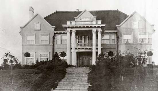
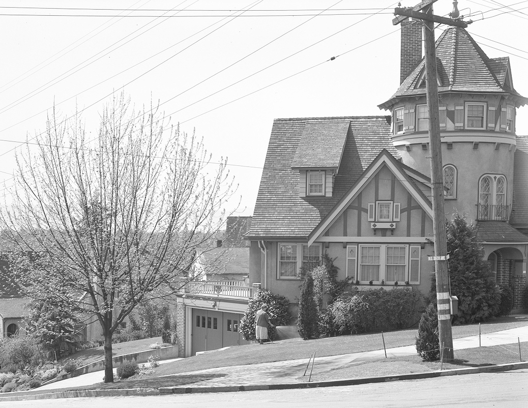
An undated but early view of the facade.

In 1915, young Frank Barnes—Frank Scott Barnes, for the record—and his wife Doris built the next family home at 3414 NE 36th Avenue. Young Frank ran the family salmon canning and packing company out of Wrangell, Alaska in the late 1920s and 1930s, where he served as mayor. Frank was killed by a grizzly bear in 1940 on a bear hunting trip in Southeast Alaska, interestingly hunting with his close friend Francis Marion Stokes, the son of the contractor who built all the Barnes houses. In a point of interest, in the mid 1940s, several years after Frank’s death, his wife Doris became the very popular and effective mayor of Wrangell, serving several terms.

Clara Barnes married Frank Collinson, who helped run the Barnes family business, and they built a home at 3460 NE 36th.

Helen married Alfred Allen and they built the house at 3526 NE Fremont. Alfred ran a subsidiary salmon packing company.

Irene married J. Wilbur Hendrickson, another partner in the salmon packing business, and they built the house at 3603 NE Klickitat.

Ivy married Louis Starr, brother of her brother-in-law (Lila’s husband) and they actually decided against living so close, a topic that probably riled Frank and Isabelle: Ivy and Louis built their home at NE 25th and Hancock, not too far away, but far enough…

And a point of order about the plat and street naming and numbering: Marguerite Avenue which you see on the plat was renamed when Portland went through a major re-addressing initiative from 1931-1933.

Here’s an illustrated map, revised in 2022 with input from family members, that may help put the pieces together:

Barnes Family at Irene Heights (revised)

Design and construction of the Barnes Mansion

Some have attributed design of the Barnes Mansion to David L. Williams, who designed the Lytle house located on NE 22nd, known today as Portland’s White House. Researchers have not come across conclusive proof, but there are certain family resemblances.

But we’re not from that school of thought, and tend to believe the home was designed and built by Stokes & Zeller, which was a large architecture and construction company in Portland during those years.

A few reasons behind this hunch: Francis Marion Stokes—the noted architect who was comfortable working in these styles and forms—was a personal friend of the family—remember that he and young Frank were on that fateful bear hunting trip together. And, Stokes & Zeller designed and built the other Barnes family homes in the neighborhood.

Regardless, the house is a masterpiece, filled with careful craftsmanship including:

  • Tile floors and marble fireplace installed by Italian craftsmen;
  • Honduran mahogany paneling;
  • Custom-made carpeting and lighting;
  • 18-carat gold threaded wall coverings in the drawing room;
  • Beautiful art glass, likely by Povey Glass.

During the Barnes years, this place was a temple for the family. A look back through newspapers of the day shows that if there was an important event, holiday or gathering, the Barnes were hosting it: weddings, masquerade balls, Christmas parties. All of the daughters were married from the home, walking down the main staircase with their wedding trains.

When Isabelle died in the house on September 19, 1930, there was only one place for the funeral and memorial: at home. The same when Frank died there one year later, mourners came to the house for a funeral and reception, and a procession to nearby Rose City Cemetery.

The next several decades were not the best for the house. Immediately after Frank’s death, the house was a rental and came into the hands for a few years of a real estate investor named Charles J. Derbes and his wife Carmen. They left by the mid 1930s, and city directories show it vacant for a few years in the depths of the Great Depression.

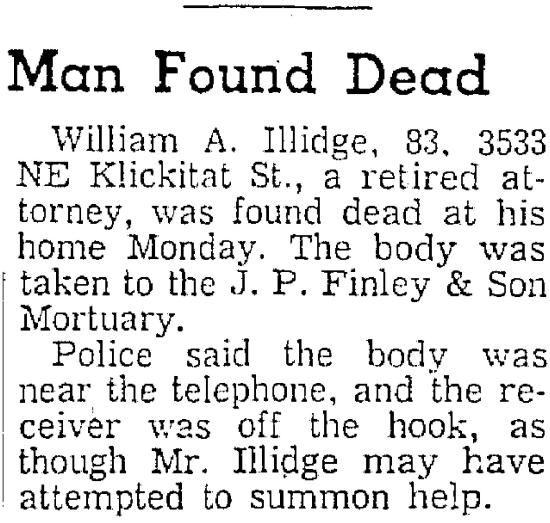
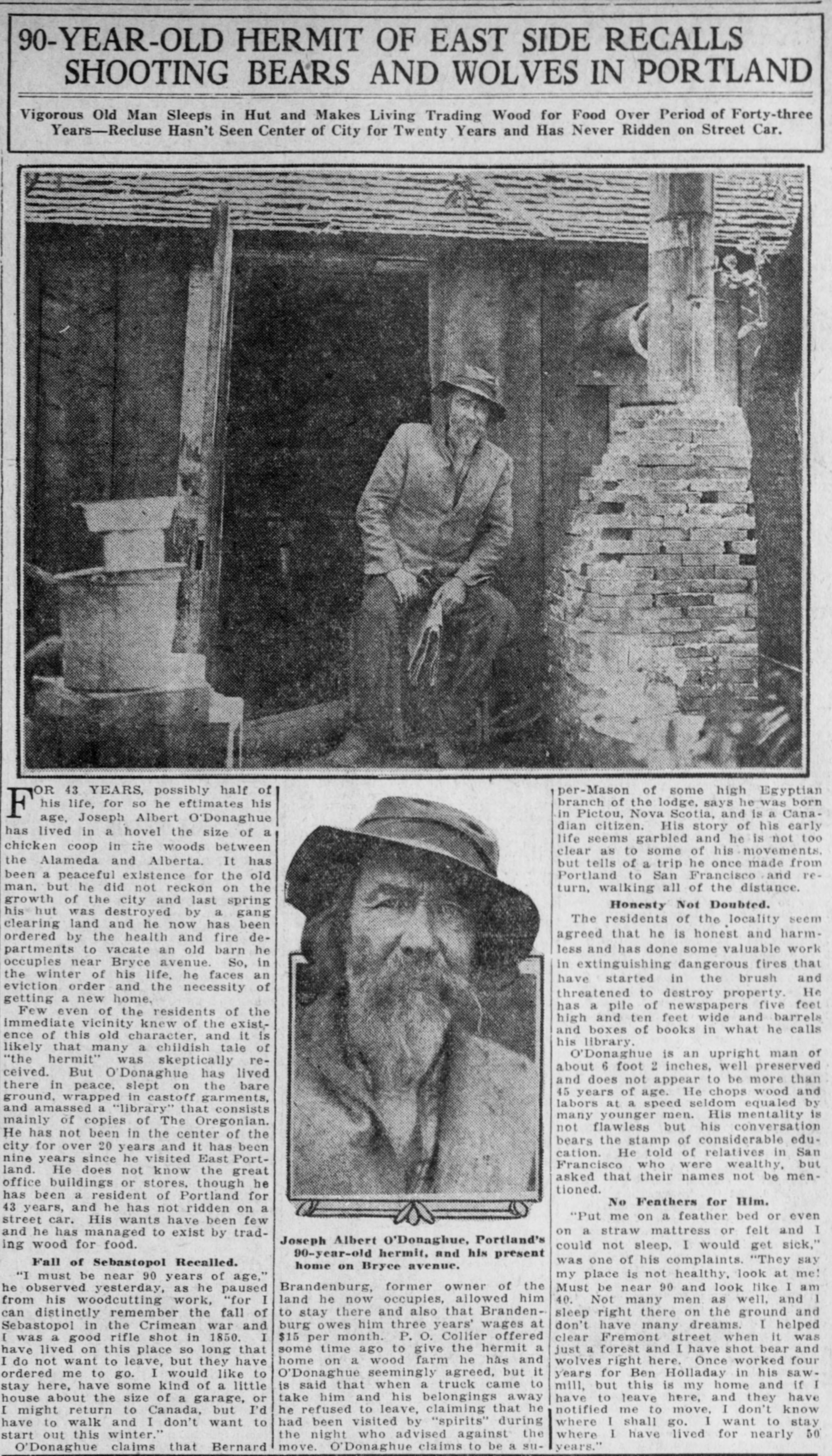
By 1937 a Portland attorney named Bill Illidge owned the house. He was disbarred in 1939 over sketchy financial and real estate dealings and through the 1940s, he gradually descended into a lonely hermit-like existence as the house and landscaping declined. He reportedly closed up most of the place and lived only in the east solarium near the front door, with a cot and a hot plate.

Illidge died in the house on December 1, 1958 and the macabre detail in the second paragraph was remembered for many years by the kids of the neighborhood.

From The Oregonian, December 3, 1958

Older kids apparently weren’t scared. The home was vacant for two more years and continued its downward slide.

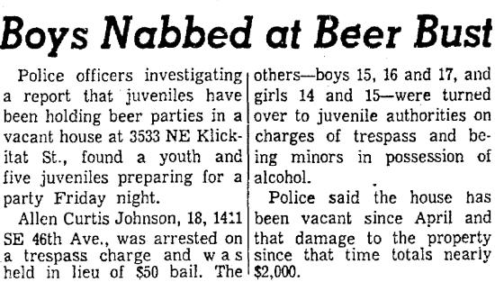
From The Oregonian, October 18, 1959

Father and son Carl and Deane Hutchison and Deane’s friend William McReynolds purchased the house in 1960 and began the slow uphill climb of restoration, which was set back by the Columbus Day Storm of 1962, which ripped off the roof, damaged the balustrades and uprooted 19 trees on the property.

The Hutchisons and McReynolds, and eventually a friend named John Jensen, continued to restore the house and added a 100-stop pipe organ and a small chapel in the house. Since 1997, the house has been owned by Merrit and Anna Quarum, who have continued its careful stewardship, which is no small feat for a 106-year-old property of this size and complexity.

The Barnes Mansion was placed on the National Register of Historic Places in 1983 and in mid-2020 is currently for sale. Go check out the current real estate listing website, for a closer look inside.

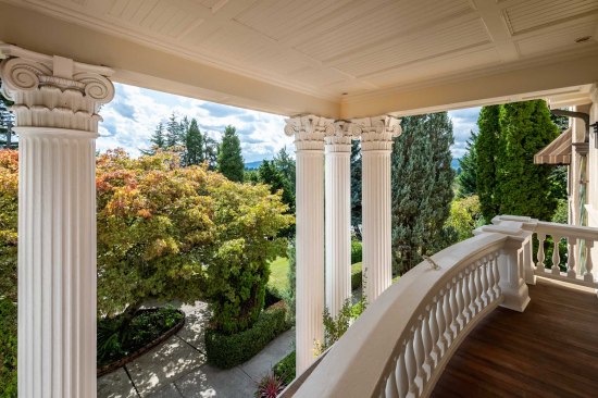
Contemporary view from the balcony looking southwest.

Home History School | Old School

A young person we know told us recently that it felt funny to say this, but he actually wouldn’t mind being being back to school. This made us smile. Schools contain so much of our lives and our memories. Friends, teachers, the playground, your classroom. The smell of the hallways, the cafeteria, the auditorium.

So this week we’re turning back the clock on a few nearby schools and the neighborhoods that surround them.

Old Vernon School, Art Classroom, about 1915.

These buildings are like time travelers that have seen change all around them: generations of kids who’ve grown up in the hallways; houses springing up here and there; school buildings themselves changing (or, like Kennedy School, closing down altogether).

This week’s activities ask you to explore places you might think you already know everything about–the immediate vicinity of nearby schools– to see and think about change. Click below for the latest installment.

Old School


Home History School | Find your streetcar

Northeast Portland streets were once alive with streetcars taking neighbors to work, school and play. They were an institution that connected us with the city and with our neighbors. Noisy, drafty, cold in winters but alive with neighbors going places, these electric-powered vehicles were loved by Portlanders, and our system was the envy of the country.

The Beaumont streetcar at the end of the line between Klickitat and Siskiyou on NE 41st Avenue, about 1914. Courtesy City of Portland Archives.

The rise of cars and buses in the 1940s brought an end to streetcars, but if you know where to look, you can still find clues, and there’s lots of photos, memories, maps and even old film to teach us about these times. This week’s activities get you looking for clues, finding your nearest streetcar route and learning about the electric trains that criss-crossed Northeast Portland neighborhoods.

Click below for this week’s installment.

Find Your Streetcar

More Time Travel on Alberta Street

It’s time for another Alberta Street merchant portrait to add to the growing collection. Meet the crew from Anderson’s Grocery Store Number 5 at 676 Alberta Street, about 1930. That’s 1816 NE Alberta today (thanks to the Great Renumbering). Sent by AH photo friend Norm Gholston, this one is definitely worth a close look so click in for a good look around.

Here’s a challenge: Think you can identify all of the produce on display?

Anderson’s Store, 676 Alberta Street, about 1930. Courtesy of Norm Gholston.

1816 NE Alberta Street, April 2020

At its peak, Anderson’s Grocery was a 39-store chain of “cash stores” (all on Portland’s eastside) built by Carl G. Anderson starting in 1905, so called because there was no book of credit kept; business was “cash on the counter” only. This particular store was Anderson’s fifth and was well established by the time this photo was taken in the early 1930s. On the back of this photo are cryptic notes explaining that the young man in the middle was the person managing the store: James Franklin Frost.

Jim Frost was born in Selma, Oregon in 1905, married Emma Doering from Saskatchewan in 1927, worked for Anderson’s in the 1930s, enlisted in the service in 1943 and returned from the war to run Frost’s Grocery on the southeast corner of NE 30th and Killingsworth. He and Emma lived within walking distance of Anderson’s, and they ran small neighborhood mom and pop grocery stores all their lives.

We’re still working on the identity of the other two gentlemen—the butcher on the left and Frost’s stock clerk partner on the right. All of them in shirts and ties and shiny shoes, how about that?

Grocer Carl Anderson was a bit of an empire builder, and definitely thought of himself that way. This business profile, written not long after the photograph was taken, provides further insight into Anderson’s humble beginnings and rise to grocery stardom.

From The Oregonian, May 4, 1935

In the year after this story, Anderson opened a grocery in a new building at the heart of the Beaumont business district which we know today as Beaumont Market.

For the record, there was also an Anderson’s Grocery at NE 15th and Fremont, but that’s a different Anderson and a story for another day…

Beaumont Market Corner: Two buildings as one

On a recent visit to City Archives, we turned up a great old photo of a local landmark you’ll recognize, and some amazing drawings that allow for Beaumont neighborhood time travel and trivia. Let’s start with the photo (from 1929) and its companion view today:

Looking south at NE 41st and Fremont. Top, September 1929. Courtesy of City of Portland Archives, A2001-062.46. Bottom, same view in March 2019.

This building was designed and built by Shipley & Snashall, a partnership between two carpenters operating from 1922 until 1931. George Shipley and Valentine G. Snashall specialized in design and construction of eastside retail spaces, though they built several residences as well.

Their most well-known work is the building that in 2019 houses Peet’s Coffee and several other shops at the northwest corner of NE 15th and Broadway—you can see clear family resemblances—which was added to the National Register of Historic Places in 1992. Shipley & Snashall completed the Beaumont building—which in our opinion is also likely register-worthy—in September 1928.

Our other recent archive discovery relates to the Beaumont Market building due east of the Shipley & Snashall building and which most people assume is all part of the same structure. Amaze your friends and neighbors with local trivia by explaining how the market building was actually built seven years after the signature buildings at the corner.

In January 1935, before being issued a building permit, architect Charles Ertz had to demonstrate how his adjacent market building would meet a contingency in zoning requirements at the intersection and be “in harmony” with the older buildings. So he submitted these colored-pencil renderings on onion-skin paper, which just about left us speechless when we found them recently. Click into these for a good look:


Here’s the related correspondence: a “do pass” recommendation from the Commissioner of Public Works and lead building official giving City Council a thumbs up to proceed, which they did unanimously.

Courtesy City of Portland Archives, reference A2001-062

Like many of us, you may have thought all those storefronts at NE 42nd and Fremont were one single building. Now we know. Tip of the hat to the architect!

If you haven’t already seen them, a ways back we shared a half-dozen or so photos of Beaumont from the 1920s along with a deep dive into the retail history of the intersection. Be sure to check them out here, here and here. And our short biography of architect Charles Ertz.


Rest of the Story: The Lost House at 33rd and Fremont

Our recent post about the old gravel pit and landfill at NE 33rd and Fremont produced some interesting mail and conversation that helps complete the picture of the house that once stood at the southwest corner of that intersection.

First, a photo from frequent AH source and long-time neighborhood resident John Hamnett showing the house. John and his father were out in the neighborhood with a camera on the sunny day following the great Columbus Day Storm of Friday, October 12, 1962 documenting damage and downed trees. John remembers they came upon this toppled fence and wall on the south side of the house. The blue and white enclosure surrounded the swimming pool. The Oregon Encyclopedia entry about the storm reports wind speeds were clocked as high as 170 mph.

Looking north at the southwest corner of NE 33rd and Fremont, October 13, 1962. Photo courtesy of John Hamnett.

Next, we re-discovered this 1954 photo looking north up the hill toward Fremont from the corner with Klickitat. When you click into this image, you can see both the mid-century modern house that was eventually removed from the site, and the house behind it, which still stands. Looks like a vacant lot just downslope.

Photo Courtesy of City of Portland Archives, image A2005-001.955. Click to enlarge.

And last, this helpful comment from Judy Wathen, who used to own the house, and remembers it from its heyday of the 1950s.

My husband and I were the ones who bought the house with the swimming pool on the corner of 33rd and Fremont in the ’90’s. Before we bought it we had two different geological engineering firms test the soil and evaluate it’s stability. Both said that it was stable and leveling the house could easily be done. Both were wrong. The cost to stabilize the house was beyond our resources. Fortunately, a grade school classmate, Terry Emmert, offered to buy the house and move it to become the first remolded home on the Street of Dreams. We sold the lot with all the engineering studies to a builder who hopefully did what was required to stabilize the land before he build what is there today.

A little bit more history about the house. I grew up in Laurelhurst in the 50’s-60’s. Our family drove by that house regularly on the way to Riverside Country Club, where we were members. My father told us about the house. My father’s friend, who owned the well known Fox Furniture Co., built the house with the swimming pool  as a wedding gift to his daughter and her husband and that it was built and finished to the highest quality. That certainly was true, except for understanding the engineering of the foundation.