Prescott Fountain–Hunderups

I’ve embarked on a line of research that involves trying to understand the businesses that have served Alamedans over the years, with a focus on the smaller shops that existed around the perimeter of the neighborhood. Here’s one that will bring back some memories for those who knew it, and will intrigue those of us who didn’t.

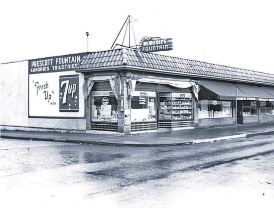
Prescott Fountain, 1955
 prescott-fountain-1955

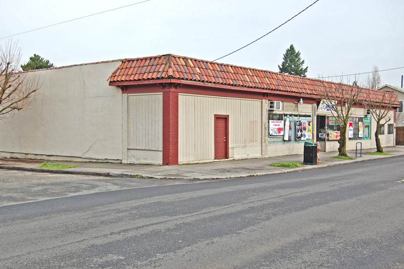
This view is looking northeast from the corner of NE 29th and Prescott. Photo courtesy of Tom Robinson, Historic Photo Archive. Below is the same place, 54 years later.


Food King Market, 2009
food-king-2009

We live not too far from Food King and drop in from time to time, almost always in the evening after other stores are closed, to get a gallon of milk for the morning. When I found this 1955 picture, I stopped in to see if the owners knew anything about the building, but they don’t, so I turned to others I know (thank you Steve Goodman and John Hamnett) who do.

The building was built in 1922, so there are a couple of generations who shopped here before this early picture was taken, and about which we don’t know much (yet). But here’s the lowdown on this place from the vantage point of the mid- to late-1950s.

I’ll let Steve Goodman tell this story from here:

First, this is actually four businesses. The left door (about one-quarter of the total building), was the Prescott Fountain. But no one called it that. From the late 50’s until it closed (sometime in the mid to late 60’s), it was know as Hunderups, for its owner (we kids pronounced it “Hun-drups”).

It was not what you might envision.  Likely in earlier days it was a modern, clean, well respected establishment, but that’s NOT how we knew it. Adults would never go in there.  It was a dingy hang-out for kids. Emphasis on dingy. It was dark (seemed like only about  two lights lit the whole place), dirty (old Mr. Hunderup, who resembled Charley Weaver, let the store go into disrepair and never cleaned it). The product on the shelves was all old and never sold. Items you’d expect in a old drug store, hot water bottles, etc.

But it did have an old fashioned counter and stools where grade school and high school kids (boys — never a girl) would gather.  He’d have candy behind the counter, but we hardly ever bought it, as fresher was available next door.

The attraction was the iced Cokes in a bottle. I don’t remember, probably a nickel or dime each.  He’d keep them in a “too cold” refrigerator, and kids would go there to socialize in an “adult free” zone, and drink the Cokes from the bottle with a straw. Sometimes Mr. Hunderup would have to break thru the ice with his ice-pick so we could get the straw in.

Rumor has it that someone once saw a rat running thru the store.  Maybe yes, maybe no – but in this dark, dirty establishment it wouldn’t surprise anyone.

My mother went in Hunderup’s once (once) looking for some item, and I think she disallowed me from going in there again — or couldn’t figure out why we’d want to.

I got the feeling that before it was the run-down place we knew, Mr. Hunderup might have owned it when it was nice and new(er), but just let it get run-down.  Looking back, he loved seeing us and chatting with us while we kept him in business.

Mr. Hunderup passed away in the late 60’s. They cleaned it all out (and we joked about how much they probably had to fumigate the place), and it soon became part of the store next door.”

Steve explains that the second door from the left was a thriving, clean, well-lit family owned neighborhood grocery called Hume’s Foods…you can see it on the awning in the photo. It sold in 1963 to the Brandel family (which later owned Alameda Foods at 24th and Fremont).

Steve remembers…

It was unlike the convenience stores of current.  They had a large produce section on the east side of the store. In the back was a large butcher case, well stocked and staffed by a real butcher. While this wasn’t a “supermarket,” it’s where many in the neighborhood did their weekly shopping; always busy. And it had several adults working there – back when they could support a family with that type of job.  No turnover, but the same people.  Mr. and Mrs. Brandel would always be in.  I can remember their faces like it was yesterday.  They kept ledgers behind the counter where some customers ran a tab.”

On the east end of the building, down beyond Brandel’s, was a beauty shop and a barber shop, complete with the twirling red and white barber pole and a row of hair dryers against the wall.

What do you know about this place? Care to share a memory about another neighborhood business?

Post Script| March 28, 2009: Thanks to the helpful memory of blog reader Steve Turner, we know that the proprieter was named August Herman Hunderup. I’ve done a little genealogy on Mr. Hunderup and learned that he was born in 1891 in Minnesota. In the 1920 census, he’s living with his parents on SE 87th Avenue and is listed as a “minister” at a Catholic Church. Death records show he passed away on September 3, 1970. I’d love to hear from any family members, or others, who have a memory of Mr. H and his quirky, memorable shop.

The First Alameda School

When most Alamedans think about our lovely old Alameda Elementary School, we are probably thinking about the beautiful and classic building that stands today on NE Fremont between 27th and 29th. Built in 1921, this school has been the neighborhood hearth for generations.

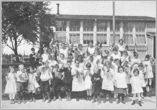
But did you know there was an even earlier Alameda School? I came upon this tidbit while reviewing 1914 articles from The Oregonian, but never dreamed I’d find a photo of the place. You can imagine how pleased I was to find this remarkable shot of the first school in the neighborhood, built in 1915. Check it out:

"First crop of radishes and lettuce at the Alameda Park School, Portland, Oregon, June, 1916. Even in the primary grades children may learn much about the science of growing things. Courtesy L.A. Alderman"

The original caption reads: "First crop of radishes and lettuce at the Alameda Park School, Portland, Oregon, June, 1916. Even in the primary grades children may learn much about the science of growing things. Courtesy L.A. Alderman"

The photo is from a book published in 1919 by Rand McNally called “Vocational Guidance for Girls,” by Marguerite Stockman Dickson. You can have a look at this book (a remarkable story all on its own), thanks to Project Gutenberg, by clicking here.  The Alameda photo is in Chapter V, where you’ll find some other interesting photos from Northeast Portland.

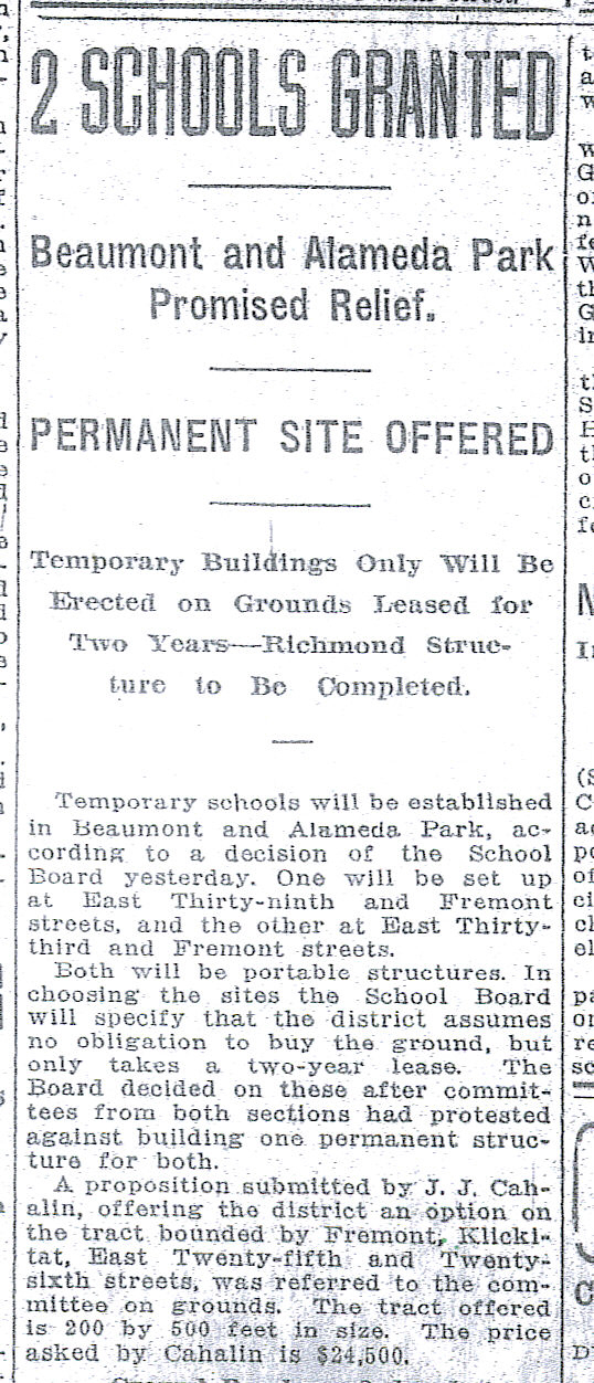
The caption clearly identifies this as the Alameda Park School in Portland, Oregon. That’s us. Pair this up with the news story from The Oregonian on September 18th, 1914 and we can begin to fit some pieces together. Take a look:

From The Oregonian, September 18, 1914.

From The Oregonian, September 18, 1914.

Things to ponder:

  • This original small school building was viewed as temporary when it was first built. Only a relatively small percentage of homes had been built in the neighborhood by then, so it was clear there would one day be a real need. Not so much in 1915, but local kids still needed a local school.
  • It was first imagined in context with a school up the road in the Beaumont neighborhood, which was also to be temporary. Like Alameda, that neighborhood was just starting out in 1915.
  • The newspaper indicates that one site for the school was at the top of Gravelly Hill, NE 33rd and Fremont. It also says the site being offered by J.J. Cahalin was on Fremont between 25th and 26th, the next block west from the current site of the Fremont United Methodist Church. I didn’t find a follow-up story, nor have I looked at the property records, but my hunch just from looking at the photo is that the Cahalin site was selected over the one at the top of the hill. I’ll run that down next time I’m looking at property records, but that just seems likely.
  • Interesting to note the tall windows, lattice-work porch and woodstove chimney. And the fact that the kids had a busy and productive garden.

Where did it sit exactly? Who built it? Who was headmaster? Mysteries yet to solve.

The Scent of Memory

I’ve just finished a history study on a two-story 1912 Craftsman in Beaumont, located on NE 41st Avenue. The story of the house is fascinating: four owners and one default in the first three years, with the title flowing from the original builder, to another contractor to a developer and back to the bank all in short order. The house itself is of interest too, with an unusual gambrel roofline dropped onto a Craftsman body.

But the pieces that will stay with me on this one are the memories of past owners. I was fortunate to find one of the children who grew up there in the late 1920s and early 1930s — now in her 80s — who shared some family stories, memories and photos. The one that sticks with me is the scent of memory, which goes something like this: in the summers, families all up and down NE 41st had wood delivered and stacked in the parking strip between the curb and the sidewalk where it cured in the summer sun. You could look up the street and see firewood stacked everywhere.

Twenty years earlier, the developers of Beaumont bragged that a dozen rose bushes would be planted in front of every lot in the new subdivision. But by the 1930s, residents had become quite practical about their parking strips, which were now a great place to dry firewood for the coming fall and winter.

So our young Beaumont girl, about eight years old at the time, always looked forward to August because that’s when men started to split the stacked wood. She remembers the sweet sappy smell of pine and fir permeating all corners of the neighborhood, and the house itself. You could smell it from Beaumont School, she remembers.

Amazing how the power of memory and smell intertwine. What scent do you remember from your old neighborhood?

A History of Snow

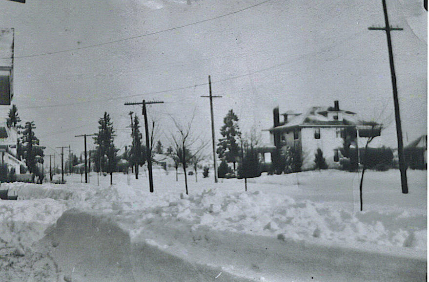
Winter 1936

Winter 1936, looking north on NE 30th toward intersection with Mason.

Winter 1936, looking north on NE 30th toward intersection with Mason. Click for a larger size image.

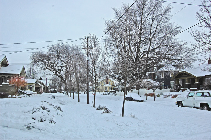
Winter 2008

Winter 2008. Looking north on Northeast 30th toward Mason.

Winter 2008, looking north on NE 30th toward Mason. Click for a larger size image.

There’s a great Billy Collins poem called “A History of Weather” that I’ve been thinking about all week. We’ve had a lot of snow here in Portland, not record-breaking, but still more than anyone has seen around these parts for 40 years. Right now we have about 15 inches on the ground and the city has been at a virtual stop for the last couple days. We started to thaw today, but another 4-8 inches of snow are in the forecast for the next couple days.

In the poem, Collins creates a funny, wistful elegy for atmospheres of the past, and contemplates weather as a common human bond across the ages. Contemplating what a weather history poem should include, Collins writes, “There will be a section on the frozen nights of antiquity…” I’ve been thinking about the frozen days and nights of the past, the transforming quiet and joy visited on the kids of this street and neighborhood over the years.

So after shoveling the front walk yesterday, I dug into my Alameda archive and found a picture taken a few doors south of my house in 1936, the year Portland received about 35 inches of snow. The photo has been passed down to me by the family of the little boy who grew up here in the teens and twenties. He was fledged by 1936 (family members were in the house til the late 1950s), but the photo stayed in his family because it depicted remarkable conditions.

Being obsessed with lining up past and present for clues, I prowled around this morning hunting — camera in one hand, old photo in the other — for the original photographer’s footprints, which are not entirely available today due to some landscaping changes down the block.

The big house on the corner (white in 1936, blue today) is the Copenhagen House, built in 1912 by the family of Les Copenhagen. Today’s big beech in the sideyard is just a start of a tree in 1936. Power poles have thinned out a bit, though still an eyesore. The gable end of the house facing the camera up the block can be seen in both images. A little closer in, if you squint at the 1936 image, you can see Walter Morrison out shoveling the front walk of my house. Farther up the block and across the street, today’s yellow Dutch colonial was just a vacant lot. Other vacant lots allow a view off into the distance.

Families in 1936 probably took pictures of their unusual winter weather event, just like we have this week. Unfortunately, most of those images are lost to time. We’re lucky to have this one, 71 years old. Makes you think about the pictures you take, the pictures you save, the pictures you decide to throw. I’m always on the lookout for old pictures of Alameda…

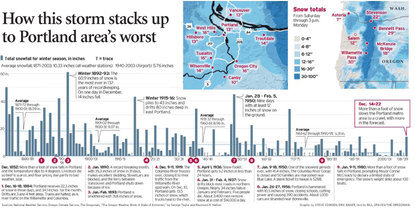
To cap off this entry about the history of snow, thought I’d share a very interesting info-graphic from The Oregonian today that clearly indicates that our predecessors knew a lot more about snow than we do. Check it out:

From The Oregonian, Page 1, 12-23-08

From The Oregonian, Page 1, 12-23-2008. Click for a larger size image.

For more insight and photos on Portland’s winter weather history, check out this post from February 2021 which turns back the clock on ice storms and river ice well into the 1850s.

History Walk | A Spin Around the Farm

Here’s another history walk–a short one this time at .6 of a mile–that will take you around the perimeter of the Pearson Farm, one of the earliest settlements in this area, dating to 1875.

The starting point for this one is easy: the Pearson Pine at NE 29th and Fremont. Go stand under its broad branches and be prepared for time travel back through our neighborhood’s past. Before you walk the farm, though, there are a few things you need to know.

The Pearson Ponderosa Pine presides over the corner of NE 29th and Fremont.

The Pearson Ponderosa Pine presides over the corner of NE 29th and Fremont.

About the Tree: This old timer has seen it all-the farms and orchards south of Fremont; the deep forest on the ridge to the north and the flats beyond that give way to the Columbia; the slow but steady reach of the street grid; an explosion of home building; construction of nearby Alameda School; the steady tide of young families moving in, and older people moving out. Like a sentinel, this tree has watched our corner of Portland grow up.

Planted in 1885 by Samuel Pearson to mark the northeast corner of his 20-acre farm, this Ponderosa pine has had plenty of room to grow to its noteworthy circumference of 15 feet, and estimated height of more than 100 feet. According to a family story handed down the years, Samuel salvaged the young seedling from an area burned by wildfire and brought it home to his farm. We nominated this as a Heritage Tree back in 2008.

About the Farm: The land was originally part of a Donation Land Claim granted by the U.S. Government in 1859 to William and Isabelle Bowering. Pearson bought the land in 1875 after it had gone through a quick succession of owners, and began to establish his farm. He was born in England, his wife Adeline in France, and together for the next 25-plus years, they tried to make a go of it milking cows on the edge of Portland. But it was not an easy existence. Cows grazed, were born, milked and died, right where today’s Alameda Elementary School sits. Contained elsewhere in the early Pearson landscape was a pond at the lowest part of the property, in the vicinity of today’s Northeast 29th and Siskiyou, with an operating sawmill nearby; pastures for the dairy cows; a large old locust tree (now gone) on Fremont at 27th and what the Pearsons described as “deep forest to the north.”

pearson-detail

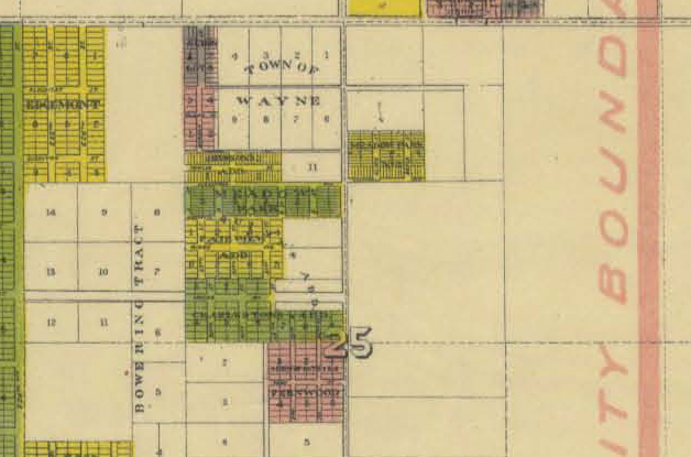
This detail from a much larger map shows the area of the Pearson farm in 1906. NE Fremont runs across the top of the frame. NE 33rd is the main road running vertically through the middle. NE 24th runs vertically on the far left side, along the edge of Edgemont. Look carefully and you can see Klickitat and Siskiyou streets. Note the Bowering Tract. The Pearson Farm is the empty lot east of Edgemont and west of the Town of Wayne. Note our proximity to the city limits: the pink vertical line on the far right shows the boundary. The large number “25” is section 25 in Township 1 North, Range 1 East of the Willamette Meridian. Click the map for a large image.

Do you have that mental picture in mind now? OK, let’s walk.

  1. Start on Northeast 29th and Fremont, under the Pearson Pine, and head south on 29th for two blocks to Siskiyou. Along the way, you’ll note an empty lot on the right a few houses south on 29th…until two years ago, this held an original Pearson house.
  2. Turn right (west) on Siskiyou. You are now walking through what was a major wetland feature and pond, maybe a seasonal creek. If you look carefully, you can see what looks like a low spot in the pavement. Where they drained the swamp. You can also see the streets don’t line up just right here…a clue to the meeting of two developments.
  3. Continue on Siskiyou to Northeast 27th. You’ve just walked past a sawmill and small log yard. Can you hear the cows?
  4. Turn right (north) on 27th and appreciate the nice plaza and grounds at Alameda Elementary School. The pasture was off to your right where the playground is today. Check out the red farmhouse on your left as you approach Fremont. The third generation of Pearsons were born here and played on the porch. One of the Pearsons once said that porch was built extra large so the kids had a place to play outside that wasn’t in the cow pasture. In that day–1908–there was no school yet, no street, no sidewalk. Just a view of Mt. Hood and their pasture off the front porch to the east, and 20 acres of Scotch broom and dogwood out the back door.
  5. Turn right (east) on Fremont and set your sights on that big Ponderosa pine, back to where you started.

Much has changed in this place since the Pearsons first shaped the landscape. But the power of memory, and the silent witness of that tall pine, remind us all about our neighborhood’s connection to those early years.

20,000 Visits

20,000 visits.

I’m pleased and a little amazed to note that the Alameda Old House History Blog has just made it to 20,000 visits. I’ve been running the blog for about a year now and have enjoyed the comments and the conversation this forum has produced. It’s also nice to have an outlet for research, and to imagine a small but loyal readership that cares about this stuff too. Thanks for being along on the journey. I hope this work has stoked your imagination and curiosity about house history.

Here are some thoughts on the past year and visitation to this site:

  • The number one most viewed page is the style points piece on the Tudor Cottage. I guess that means there are lots of Tudor cottages out there in the world. The second most popular spot on the blog is the story on Alameda Life 1920-1930 which tries to imagine life here based on what the Federal Censuses offer.
  • The busiest day for traffic on the site was December 8, 2007. On that day, the blog was mentioned by Jack Bogdanski at www.bojack.org (which is an interesting blog, by the way).
  • Typically, the site sees about 70-100 visits a day. Daily visits tend to peak up into the hundreds immediately after the Alameda Newsletter is distributed (I write a history column in that newsletter and pick up some readers from there).
  • The two quietest days of the year: Christmas and election day!

Plans for the next year include:

  • I’ve just changed the domain name to make life a little simpler. Maybe you noticed: it’s www.alamedahistory.org The former URL works too, but it’s a mouthful to say.
  • I’ll continue to share some of the material I’ve gleaned from reading all the old newspapers. I’ll upload stories, graphics, photos, advertisements and other tidbits.
  • I’ve just started the process of nominating my home for listing on the National Register of Historic Places. I’ll write about that process and offer insight into its twists and turns as they unfold.
  • I’m going to try to focus on interpretation that you can use. Places where I can point you in the neighborhoods as entry points for learning about history. I’ve tried to do this with the history walks, but will continue to seek ways to do this. Open to ideas.

To those who have commented or pointed me in search of history, I say “thank you.” To all visitors, I invite you to contribute your thoughts, ideas and questions.

Remember Manitou?

It’s OK if you’ve not heard of the Manitou Addition, a small chunk of neighborhood that once had its own identity, now lost to time. In my research on Alameda-Beaumont-Wilshire, I’ve kept running into references to Manitou-this and Manitou-that and wondered where it was. While reviewing plat maps recently, I found it: the long block between 33rd and 35th that includes the north side of Fremont and both sides of Alameda.

Manitou Plat Detail, March 3, 1910

Manitou Plat Detail, March 3, 1910

The plat for Manitou was incorporated by Fred and Gussie Jacobs, who were partners in the Jacobs-Stine Company, which platted many Portland subdivisions with fancy sounding names, only two of which are in circulation today-Errol Heights and Argyle. Fred Jacobs told a reporter in April 1910 that Manitou was named for Manitou Springs, a picturesque mountain community about 65 miles south of Denver. (Incidentally, Fred Jacobs was the Portland real estate man who died in the crash on Stuart Drive that resulted in it being known as “Deadman’s Hill.“)

Of course, when I found Manitou, it begged another question because that plat is a subdivision of the Spring Valley Addition. Now there’s another name that has fallen out of use. Spring Valley is easily one of the oldest plats in the area, filed on November 6, 1882 by one “Clara L. Files, Spinster,” and encompassing the area east-west between 33rd and 37th and north-south between The Alameda and Skidmore (including Wilshire Park). Interesting to note that until 1941 (when development really came to that part of the neighborhood) the Spring Valley plat showed a major planned north-south thoroughfare called Broadway, located about where NE 35th is today.

The cumulative mushroom effect of historical research guarantees that you can’t look into the history of the Spring Valley Addition (or Manitou) without bumping into other nearby mysteries, including plats for Maplehurst (south of Fremont), Irene Heights, Fullerton, Whiterose, Rossdale, Rosyln, Calman, Wilshire and Railroad Heights (nope, no railroads ever ran up here, but you might have been able to hear a train or two).

History Walk | Alameda Park Perimeter

These fall evenings are great for a brisk walk. Leaves everywhere, woodsmoke in the air, raindrops. And local history ripe for the imagination.

Alameda Park Plat Map, c. 1912

Click on the map for a larger file you can print

The northwest corner of “The Park” (as in the Alameda Park subdivision) is a little confusing, particularly around Crane Street, which has been significantly changed over time (and is actually part of the Vernon plat). Rather than trying to follow the zig-zag of the property boundary, I just walked Prescott to NE 20th to the shadow of the big water tower. Then south to Alameda Drive and around the corner to 21st, then west on Ridgewood to 20th, and then left down the hill. When you are on 20th above the ridge, from Prescott to Alameda, you can see the difference in the neighborhood plats, with Sabin to the west on one side of the street with smaller homes on smaller lots.

Turning left (east) on Fremont, you have the long straight south edge of The Park to walk, passing by where the streetcar ran up 24th and the busy commercial hub that included the Alameda Pharmacy, the old Safeway (now the bank) and what used to be two gas stations. I think of the northeast and northwest corners of NE 24th and Fremont as the gateway to The Park because that’s where the streetcar ran, and because of the business district here.

Next, you pass east by the school, built in 1921 after much lobbying by the locals and a few protests that the construction contract was awarded through some favoritism (future blog post, stay tuned). The plats off to your right are Waynewood, the Town of Wayne and Edgemont, names long forgotten.

Tip your hat to the Pearson Pine, the big old ponderosa pine tree on the southeast corner of NE 29th and Fremont. It’s been there since at least 1885.

Up the hill you go. As you pass the staircases that head up to the top of the ridge, keep in mind there are old water mains under those steps, placed when they were built in the teens. At one point, maybe in the 1920s and early 1930s, women from the Alameda Tuesday Club acted as ushers for young children passing up and down these stairs on their way to and from school.

The crest of the hill at Fremont and 33rd is Gravelly Hill, which was both a gravel pit and garbage dump for many years. The dump was under the southwest corner, where a fine house sits today.

As you walk north on 33rd, think about the 33rd street woods (today’s Wilshire Park), originally part of the Kamm Estate, which was a dense forest that played a large part in the memories of youngsters who grew up there in the 1930s and 1940s. While you’re enjoying the evening, you can also tip your hat to the home guard, made up of Alameda dads, who patrolled the neighborhood at night during the World War II years, enforcing blackout rules and making sure families kept blankets and light dampers up on their windows.

And then there are the thousands of stories that rise up from the generations who have lived in the homes you’ll pass. Lots to wonder about as you and the dog push on around the corner at Prescott and head into the home stretch (being sure to have a look up the alleys north of Prescott as you scope your next walk). So nice to be out on a history walk on a brisk November night.

Next: Walking the route of the Broadway Streetcar.

Beaumont, not to be outdone

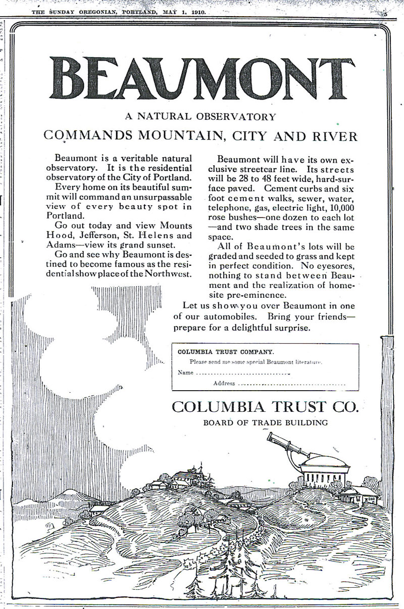
Not to be outdone by Alameda Park or Olmsted Park or any of the dozen-plus subdivisions beginning to spring up about this time, the Columbia Trust Company commissioned their own artwork (and copywriter) to sing the praises of their development. Take a look:

Beaumont Ad, The Oregonian, May 1, 1910

Beaumont Ad, The Oregonian, May 1, 1910

If you squint just right at their ad, you can imagine Wisteria or NE 42nd Avenue curling down from the ridge. But when this ad ran in the spring of 1910, the big improvements in Beaumont–paved streets, sidewalks and graded lots–were still more than a year away. In fact, real estate folks in existing developments like Irvington went out of their way to point out that places like Beaumont and Alameda Park were just pipe dreams, and only they were able to sell actual houses on actual lots in neighborhoods with actual paved streets. Competition for buyers was as fierce as the pace of homebuilding, which was faster and more ambitious than anything before or since.

The Tuxedo of Portland | Looking Back 99 Years

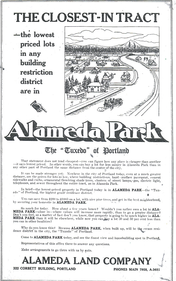
As the Alameda Neighborhood approaches its 100th anniversary, I thought it might be of interest to turn the clock back for a sense of what people were thinking about this part of the city in those days. I’ve done a comprehensive review of The Oregonian from 1909 to 1929 and have hundreds of articles and advertisements that shed light on the life of Alameda, Beaumont, Rose City Park and other Northeast Portland neighborhoods. Here’s one, an advertisement from 99 years ago: Sunday, October 24, 1909:


10-24-09 Advertisement for Alameda Park Neighborhood, from The Oregonian

10-24-09 Advertisement for Alameda Park Neighborhood, from The Oregonian


Plenty of food for thought here. The cartoon-like drawing showing a few houses (note the front porches) scattered on open blocks; the serpentine Alameda leading off toward Mt. Hood; street trees planted in orderly fashion. And the car. The text extols the affordable nature of the lots here in Alameda Park, the amenities, including flowering shade trees, telephone, electricity and sewer. The “Tuxedo” of Portland. Hmm.

Ninety-nine years ago this month, the streets were in, but not yet hard-surfaced (that was still almost three years off, completed in the spring of 1912). Curbs and sidewalks had not yet been framed and poured, nor was there any gas or electric installed. The only sounds of home construction were coming from Concordia and Vernon–neighborhoods to the north–where building was fast and furious. But here in Alameda, despite what the ad might have you think, it was a quiet place at the far northeast edge of the city limits. The first boom of Alameda construction was still a year or more away.

As we enter the 100th anniversary phase, in 2009-2011, I’ll be sharing clippings on a “real-time” basis. You can read all the Alameda news that was fit to print on the day it ran, exactly 100 years ago. What better way to learn about our history…no such thing as old news.