Alberta Park Marks 100th Anniversary

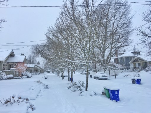
Alberta Park marks its 100th year in 2017, originally leased from a local property owner and then condemned by the city in 1921 to provide needed park and open space for the growing neighborhood.

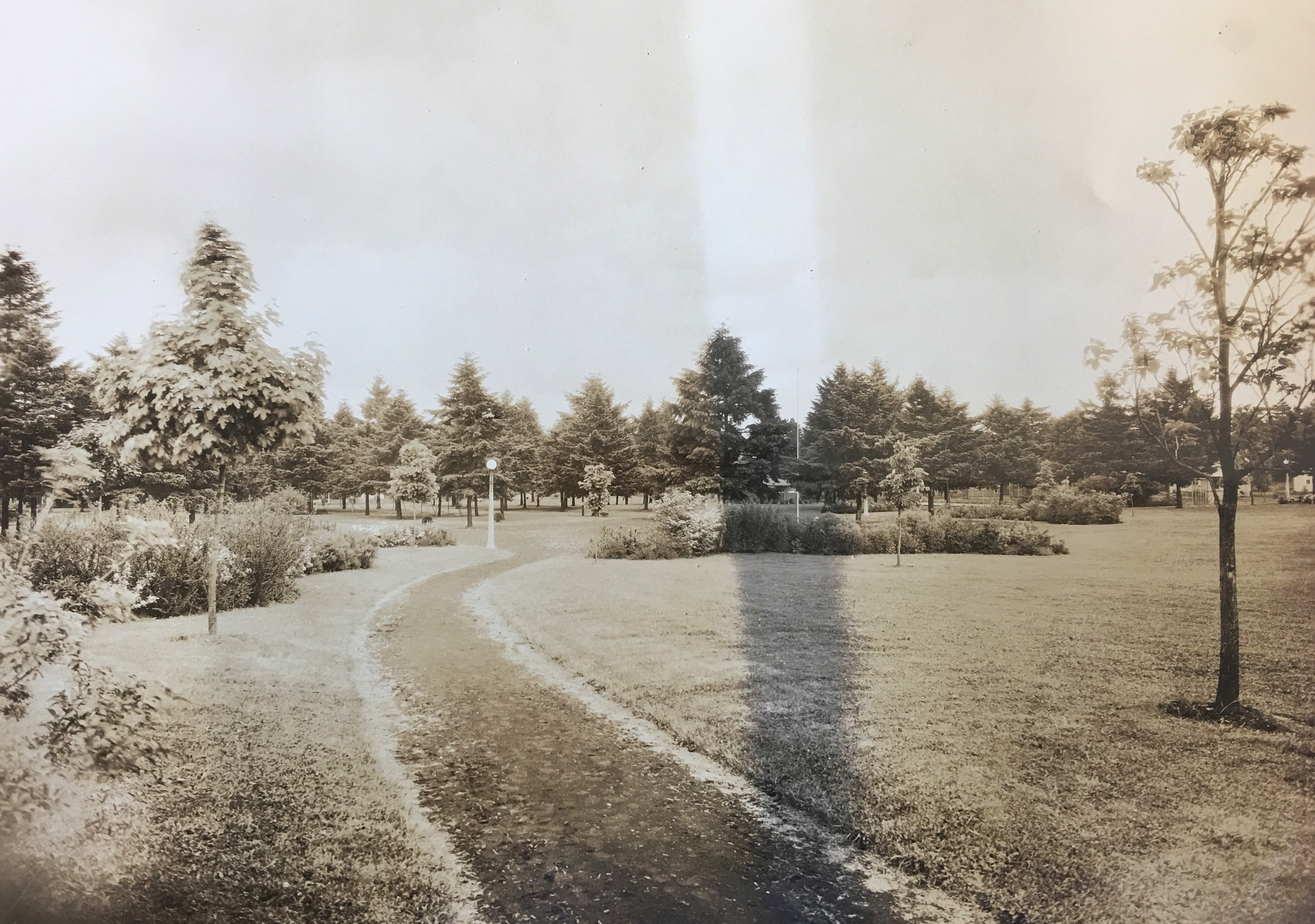
Alberta Park 1929. Courtesy City of Portland Archives.

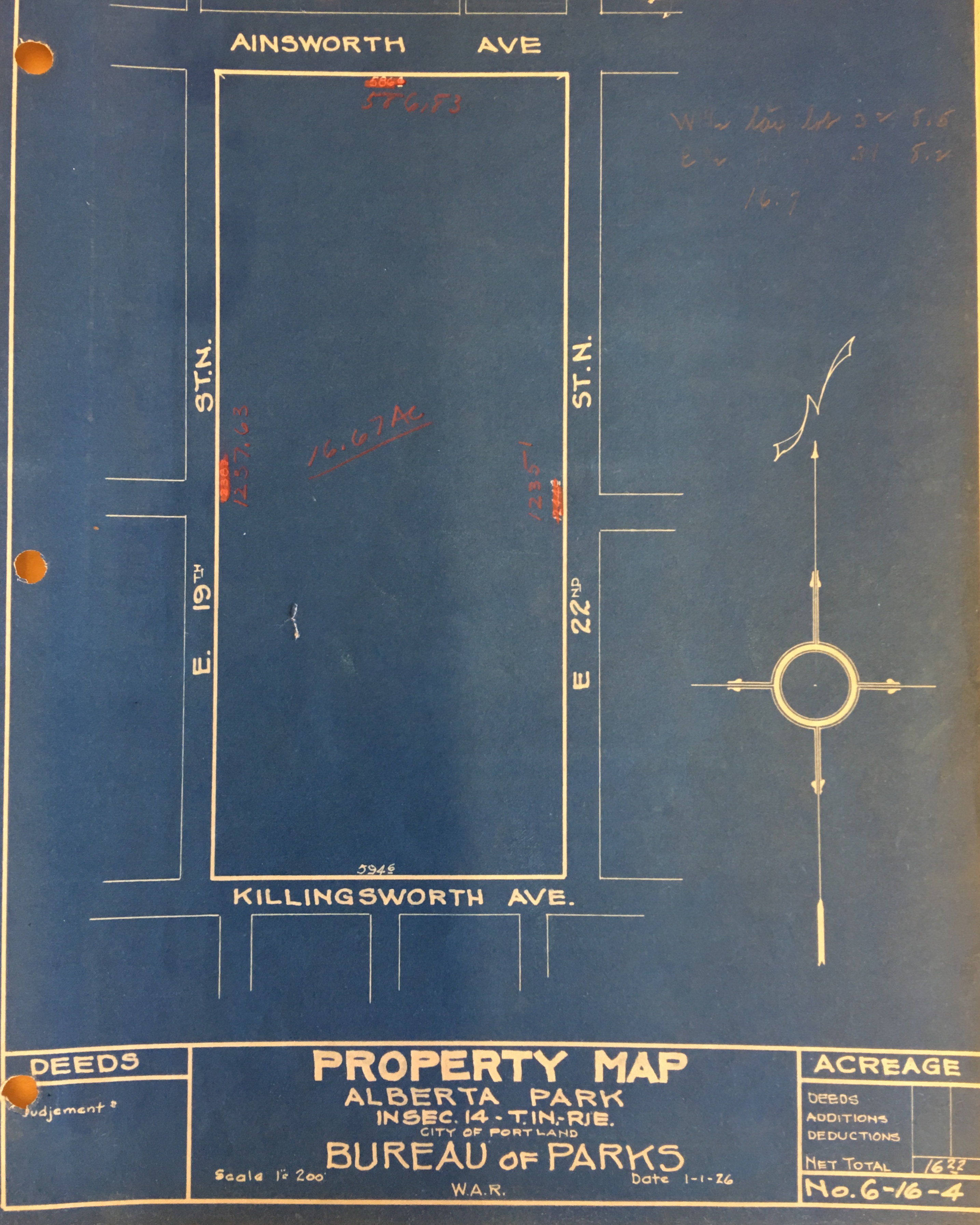
Like many areas of our city, northeast Portland’s neighborhoods evolved from Homestead Act land claims, where settlers bought or received rights from the federal government to develop open land for farms and homes. The recorded real estate transaction history of the Alberta Park area begins in 1866 when Mexican-American War veteran Harry McEntire used his Military Bounty land exchange certificate to acquire the property bounded by today’s Ainsworth, Killingsworth, 19th Avenue and 22nd Avenue: what we know today as Alberta Park.

As developers began to lay out streets and neighborhoods for the area beginning in the early 1880s, the property changed hands. Chinese business leader, landowner and entrepreneur Moy Back Hin, referred to by The Oregonian at the time as “Portland’s first millionaire” acquired the property, along with other real estate he owned downtown and on the eastside. Hin was frequently in the news for his real estate dealings and as a leader of Portland’s vibrant Chinese community: he served as Chinese Consulate General to Portland.

In 1910, Hin called on the city to follow through with plans to open Killingsworth Avenue between Union Avenue and NE 42nd (a $150,000 project for which the funds had not yet been identified) saying that as soon as the street was opened he would begin to build houses on his land.

During those years, eastside home construction was exploding: commercial development booming along Alberta Street; a vibrant home building business across nearby neighborhoods; a major streetcar line—packed with commuters—serving these new communities carved out of the fields and forests northeast of downtown.

Through its community clubs (of which there were many), locals began calling for development of parks. Influential Catholic priest The Reverend James H. Black—who went on to lead southeast Portland’s St. Francis Parish for many years–appeared before the Portland Parks Board to encourage the board to purchase land for a park in the Alberta area before real estate values jumped.

Minutes of the meeting show the chairman informed Father Black that “at present there are no funds on hand to purchase park property, and suggested that he write a communication to the Board incorporating his ideas in regard to the proposed Alberta Street Park property.”

In November 1912, locals petitioned the city, saying the more than 14,000 new residents of the area deserved a safe place to recreate and noting that nearly all the available lots for playground space had already been built over.

From The Oregonian, November 3, 1912

By 1917, the last remaining unplatted stretch of land in the area was the 17 acres bounded by 19th, 22nd, Killingsworth and Ainsworth, owned by Moy Back Hin. While Hin did eventually planned to develop the area for homes, he agreed to lease the property to the city starting in 1917 to serve as a park. Almost immediately, baseball diamonds, a clubhouse, walking paths and restrooms were built on the leased property.

In 1920, with the parcel in popular public use (and Killingsworth Avenue now open and paved between Union and NE 42nd), Hin offered to sell it to the city for $65,000, which was refused. The city responded with an offer to buy it for $39,333, which Hin refused. City Council responded on March 23, 1921 with an ordinance condemning the property and ordering it taken over by the city. After a jury trial, Hin was paid $32,000 and the property was taken over as a “public necessity.”

In 1924, the city passed an ordinance naming the parcel Alberta Park, though it was frequently referred to as Vernon Park as well. Hundreds of newspaper references to the park—and to the robust City League baseball schedule that occupied the new baseball diamond and sometimes drew more than 1,000 spectators—randomly used both names. Use of the Vernon Park name faded by the 1940s.

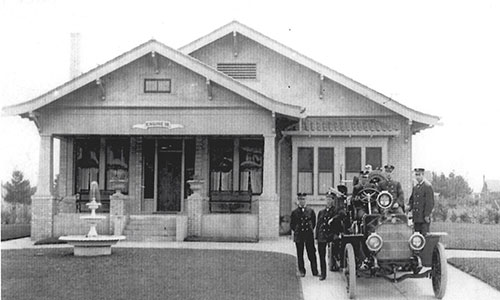
Investment immediately followed the city acquisition. A 1927 inventory of the property identified the following improvements:

1 wooden field house, built 1922 for $500 (heaters to be installed in 1927)

Two comfort stations (including a tool room) built in 1926 for $5,000

Sewer and water connections

One shelter

1925 plantings: $1,096

1926 plantings: $223.47

27 lights, cost $3,469.21

70 hose bibs and four automatic sprinklers

One large baseball field with backstop

One small baseball field with backstop

One wading pool, built in 1927 for $719

4 sets of horseshoe courts with steel frames and covers

2 sand courts ($100 and $108.72)

1 handball court

2 tennis courts ($1,722.58 and $2,055.86)

1 flag pole

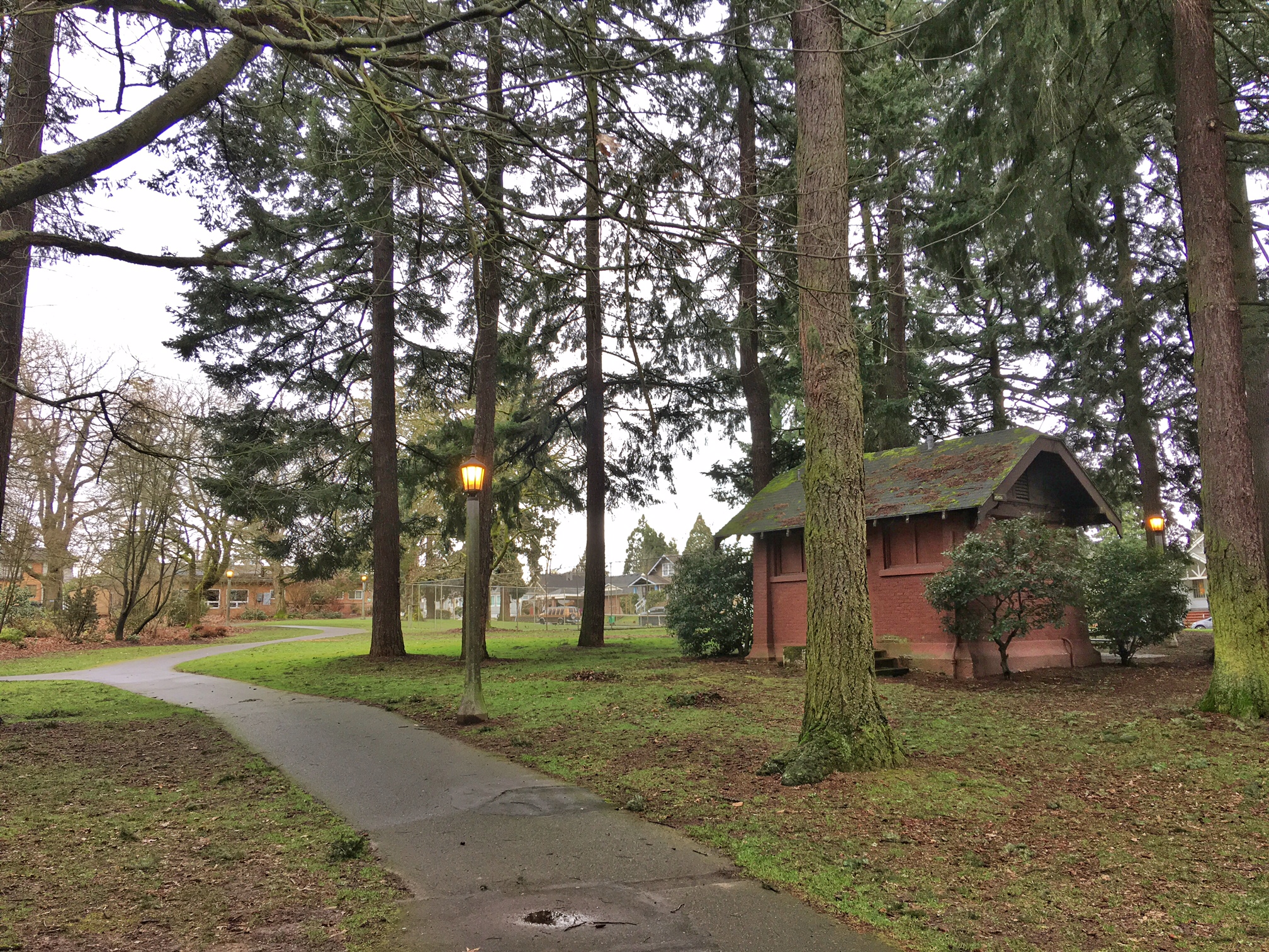
Alberta Park “comfort station” and lamps date to 1926.

Hundreds of references in newspapers of the day called the new parcel as Vernon Park and sometimes used the two names interchangeably in the same story, but on April 9, 1924 the city passed an ordinance officially naming it Alberta Park. The official name change didn’t seem to stick: newspaper references to Vernon Park show up well into the 1940s.

An annual summer community picnic tradition connected neighbors of all ages and included a parade, games, the naming of a local queen, dancing and a lantern parade after dark.

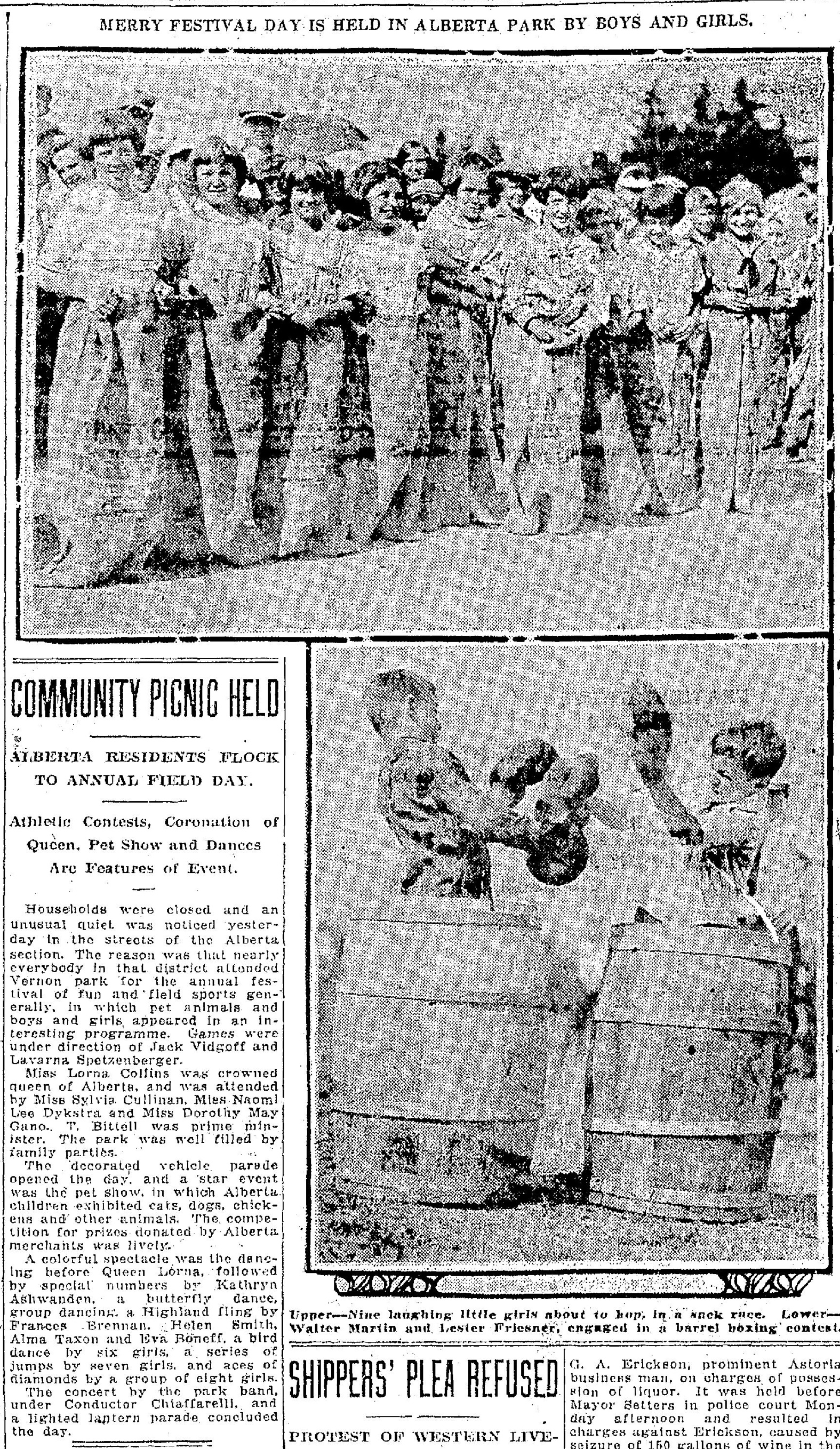
From The Oregonian, August 16, 1924.

In October 1927, the Portland School District tried to acquire the southern five acres of the park as a location for the “new” Vernon School being planned to replace the original Vernon School south of Alberta Street that had become too small for the growing neighborhood. The city attorney, referencing the 1921 condemnation order and its intent that the property was acquired specifically for a park, refused to budge, protecting the park we know today. The school district scurried to find a site, selecting the current school location on the south side of Killingsworth Avenue across from the park.

In the 1950s, despite a fractious encounter with the neighborhood that included references to the 1927 decision by the city attorney not to subdivide the park, the city made a different decision and did allow use of the southwest corner of the park for construction of Fire Station 14.

Aside from the new fire station, not much changed in Alberta Park until the 1970s, when a comprehensive planning effort and citizen survey recognized a changing pattern of use. The 1972 report found:

“Alberta Park has remained relatively unchanged from its original development in the 1920’s. However, the interests of the users of Alberta Park have changed extremely. At this time we find Alberta Park as a park with high usage by children, while maintaining a passive character of walking and picnicking.”

In the 1920s and 1930s, the park was a kind of every-person’s backyard, where the community went in family units to picnic, play, celebrate, appreciate the plantings. By the 1970s, the car was much more a fixture of family life. Plus, the demographics of the neighborhood were changing and spending leisure time in a park as a family unit was no longer a high priority. The park was for young people.

As part of the 1972 master planning effort, 1,800 surveys were mailed to homes in a radius of six blocks from the park. The 182 replies that were returned ranked park needs, and 44 percent of the respondents raised concerns about park safety.

Drawing on the survey results, the 1972 Alberta Park Master Plan called for a new set of priorities, including adding a covered and lighted basketball shelter ($73,000); installation of tot play equipment ($2,000); paving of the existing gravel paths ($3,000); and resurfacing of the tennis courts ($2,000). These improvements were carried out over the following years as funds were available.

The park continues to be a community fixture: the sounds of pick-up basketball games can be heard on weekends and evenings; the upgraded playground structures filled with youngsters; and come spring the timeless sounds of baseball.

Alberta Streetcar: Catalyst for Change

It takes lots of imagination to conjure up a picture of what our neighborhood might have looked like 100 years ago. The fields and forests of today’s Alberta district, Vernon, Concordia, and Alameda were way out in the country, beyond the far edge of Portland. But one key development changed all that: the Alberta Streetcar.

a2009-009-4152-streetcar-along-alberta-line-1944

A photo of the Alberta Streetcar from 1944 looking north on NE 30th Avenue at the line’s far northern end, NE 30th and Ainsworth. Only the building on the northeast corner remains. Development of the streetcar line changed everything about the landscape that eventually became our neighborhood. Photo courtesy of City of Portland Archives.

First constructed in 1903, the line left downtown at SW 2nd nd Alder, crossed the old Steel Bridge and ran north up Union (today’s Martin Luther King Jr. Blvd.), where it turned east on Alberta to NE 25th. A few years later it was extended five blocks east on Alberta to NE 30th, and then a few years later north on NE 30th to Ainsworth, which became the end of the line. For a time, there was talk of connecting the Alberta line with the Broadway line, which terminated in Alameda at NE 29th and Mason, but by the time that seemed possible, automobiles had begun to eclipse streetcar use.

Wherever the streetcar went, so did development. Initially just two rails in the mud through brush and open fields, by the heyday of Portland’s streetcars in the teens and 1920s, the Alberta streetcar had attracted scores of business owners and thousands of residents to this new developing part of the city. Its impact on the shape and feel of the neighborhood can’t be overstated.

The December 28, 1913 edition of The Oregonian reported:

“The streetcars are now operated to East Thirtieth street and Ainsworth avenue. The line runs double cars in order to take care of the traffic and even then the cars morning and evening are overcrowded.”

The fact that autos were not the primary mode of transport in those early days meant streetcars—and lots of foot traffic—fueled growth of the business district along Alberta. It was a thriving place of activity and commerce, not unlike today. But by the 1940s, with automobiles dominating the transportation picture and Union Avenue no longer the main north-south travel corridor (travel had shifted to Interstate Avenue), the Alberta streetcar became disused and was eventually replaced by a bus. By then, Portland had turned its back on its once robust streetcar system. The last day for the Alberta line was August 1, 1948.

As if to silence the era of the Alberta streetcar once and for all, in September 1949 The Oregonian reported that the City of Portland authorized a $75,000 paving contract that took 11 days to erase all evidence of the tracks:

“A total of 110,748 yards of materials went into the project to bury the old Alberta streetcar tracks. Paving tonnage amounted to 8,407 tons of blacktop.”

Today, there aren’t many specific clues other than the hundreds of streetcar-era buildings that would not have developed without the line. When you’re out for a walk along our neighborhood’s path of the old streetcar line (1.8 miles along Alberta between MLK and 30th; then 30th Avenue between Alberta and Ainsworth), see what evidence you can find.

More History of Snow

In honor of the recent heavy snowfall here in Portland (about 13 inches here at our house so far, with up to five more inches on the way), we’re going to reprise and slightly update one of our favorite posts from the AH blog archive, “A History of Snow,” written in December 2008 after Portland received more than a foot of snow. Yes, we have a lot of snow on the ground at the moment, but for perspective, 67 years ago on this date, Portland was in the process of receiving 44 inches of snow, one of its heaviest snowfalls in recorded history. Enjoy this look back as we celebrate how a heavy snowfall is timeless and brings quiet to the neighborhood.

DD

———

Winter 1936

Winter 1936, looking north on NE 30th toward intersection with Mason.

Winter 1936, looking north on NE 30th toward intersection with Mason. Click for a larger size image.

Winter 2008

Winter 2008. Looking north on Northeast 30th toward Mason.

Winter 2008, looking north on NE 30th toward Mason. Click for a larger size image.


Winter 2017

january-2017-snowstorm

Winter 2017, looking north on NE 30th toward Mason.


December 23, 2008–There’s a great Billy Collins poem called “A History of Weather” that I’ve been thinking about all week. We’ve had a lot of snow here in Portland, not record-breaking, but still more than anyone has seen around these parts for 40 years. Right now we have about 15 inches on the ground and the city has been at a virtual stop for the last couple days. We started to thaw today, but another 4-8 inches of snow are in the forecast for the next couple days.

In the poem, Collins creates a funny, wistful elegy for atmospheres of the past, and contemplates weather as a common human bond across the ages. Contemplating what a weather history poem should include, Collins writes, “There will be a section on the frozen nights of antiquity…” I’ve been thinking about the frozen days and nights of the past, the transforming quiet and joy visited on the kids of this street and neighborhood over the years.

So after shoveling the front walk yesterday, I dug into my Alameda archive and found a picture taken a few doors south of my house in 1936, the year Portland received about 35 inches of snow. The photo has been passed down to me by the family of the little boy who grew up here in the teens and twenties. He was fledged by 1936 (family members were in the house til the late 1950s), but the photo stayed in his family because it depicted remarkable conditions.

Being obsessed with lining up past and present for clues, I prowled around this morning hunting — camera in one hand, old photo in the other — for the original photographer’s footprints, which are not entirely available today due to some landscaping changes down the block.

The big house on the corner (white in 1936, blue today) is the Copenhagen House, built in 1912 by the family of Les Copenhagen. Today’s big beech in the sideyard is just a start of a tree in 1936. Power poles have thinned out a bit, though still an eyesore. The gable end of the house facing the camera up the block can be seen in both images. A little closer in, if you squint at the 1936 image, you can see Walter Morrison out shoveling the front walk of my house. Farther up the block and across the street, today’s yellow Dutch colonial was just a vacant lot. Other vacant lots allow a view off into the distance.

Families in 1936 probably took pictures of their unusual winter weather event, just like we have this week. Unfortunately, most of those images are lost to time. We’re lucky to have this one, 71 years old. Makes you think about the pictures you take, the pictures you save, the pictures you decide to throw. I’m always on the lookout for old pictures of Alameda…

To cap off this entry about the history of snow, thought I’d share a very interesting info-graphic from The Oregonian today that clearly indicates that our predecessors knew a lot more about snow than we do. Check it out:

From The Oregonian, Page 1, 12-23-08

From The Oregonian, Page 1, 12-23-08. Click for a larger size image.


Some notable observations from this 2017 storm:

  1. NE 33rd Avenue is closed up Gravelly Hill (from Knott to Fremont).
  2. Deadman’s Hill is jammed with skiers, snowboarders and sledders of all ages.
  3. Pretty much everything official is closed and the city is requiring chains on all Portland streets.
  4. 33,000 PGE customers are without power.

What’s your snow story today?

Alameda History Lecture at Architectural Heritage Center | January 28

Stories of Alameda’s founding and early life will be topics of a presentation we’re making at Portland’s Architectural Heritage Center on Saturday morning, January 28, 2017 at 10:00 a.m. Here’s a link to more information and how to register (registration through AHC is required).

church-1923

Students pose in front of the Alameda Park Community Church in 1923, one year after its construction. Located near the corner of Northeast Regents and Skidmore, the building is known today as the Subud Center and looks much like it did then. The upcoming presentation at AHC will explore the history of this building and many other Alameda institutions.

Through maps, photos, stories and memories, we’ll explore how the pre-neighborhood landscape evolved, how it was developed by the Alameda Land Company, and then how architects, builders and families shaped it into the neighborhood we know today. We’ll also examine neighborhood institutions including our business district, the streetcar that served the neighborhood, schools, churches and parks. This is an encore presentation that will bear a resemblance to other programs we’ve done for AHC, but with significant updates based on ongoing research.

We’re always glad to consider requests for group programs or guided neighborhood history walks. Just drop us a line.


Backstory of a favorite local fire station

Picking up the local fire station thread where we left it: here’s a story about how the siting of public facilities in the early days was more about administrative prerogative and less about public input. Portland Fire Station 14 as we know it today is one such story.

station-14

Portland Fire Bureau Station 14, NE 19th and Killingsworth

In 1958, with the closure of the old fire station on NE 33rd and with a new fire chief in place, Portland set about reconfiguring its overall fire response network. Several of the older smaller stations across the city were closed. New stations were planned. A $3 million bond levy passed by popular vote, and seven new stations went into development across the city, serving (and changing) the neighborhoods where they landed.

Fire officials wanted something more central to the Concordia neighborhood, and they didn’t mind something that would also be expedient. Those criteria focused planners on a parcel the city already owned: a quarter-acre at the southwest corner of the popular 16-acre Alberta City Park, bounded by Killingsworth on the south, Ainsworth on the north, NE 19th on the west and NE 22nd on the east. It’s a great park.

From an expediency standpoint, this made sense: lots of surrounding housing that needed fire protection; it was near a school that would also benefit from quick response; it was on a major east-west thoroughfare for good access. Not quite like building a tennis court or swimming pool, but doable.

Problem was, there wasn’t much conversation with the neighbors.

3-4-1959-construction-men-enter-park

The back-and-forth between the city and the neighborhood that followed would give even the most veteran city PR person the heebie-jeebies. Articles in The Oregonian from July 1958 until March 1959 describe how the neighbors opposed construction at first politely, which ratcheted up to petitions signed by 400 neighbors and sit-in protests against the station by the Vernon PTA, letters from the pastor at the Vernon Presbyterian Church, formation of a lobbying group called “Save Portland Parks,” a strident letter writing campaign by neighbors, and—after the city decided to go forward with the project even in the face of local opposition—an arson attack on the construction site on the night of March 3, 1959. Yes, you read that correctly.

The opposition group leader eventually gave up when the city persisted: “We don’t like it, but we can’t do any more,” Dorothy Rapp told The Oregonian on March 5, 1959. “It’s fruitless to fight city hall any longer. There’s no sense in beating our heads against the wall.”

Today, Station 14 has become part of the fabric of the neighborhood, welcomed and appreciated by all, or at least taken for granted. The engine and four personnel stationed there respond to 2,500 calls for service each year.

We’ve overcome this particular history (and hopefully learned from it), but as we know, it’s always insightful to remember how things came to be.

Fire stations and our changing neighborhoods

Long-time AH readers know about our focus on trying to better understand neighborhood institutions and the legacies they’ve left. Over the years, we’ve looked closely at things like Mom and Pop grocery stores, local schools, the Broadway Streetcar, Wilshire Park, local churches, business districts.

Here’s another institution that has left a legacy: our local fire stations.

12-3-2016-concordia-fire-station

In the 1920s, single-engine fire stations blended in to east side neighborhoods. Here’s Station 18, at 2200 NE 24th Avenue, built in 1912 to look like its bungalow neighbors and in active use until 1964. Nice fountain!

If you like to look at old buildings, you’ve probably noticed the red brick building on the east side of NE 33rd near Alberta Court, now home of the Oregon Stamp Society (4828 NE 33rd). If you’ve thought there’s something institutional about it, you’d be right.

attachment-1-3

Here’s the former home of Engine 34, 4828 NE 33rd, in the early 1960s, not long after the Oregon Stamp Society purchased the building. We’re on the lookout for earlier photos showing the station in active use.

Opened on November 1, 1928, with Captain Dan Shaw in charge and R. Mitchell as junior captain, the station was originally the home of Engine Company 34.

Over the years, the station also served as neighborhood polling place, toy drop-off during Christmas charity drives, and the focus of summer community barbecues and open houses.

During the teens and 1920s, several similar small fire stations housing just one engine and known as “three-man stations” were constructed in the heart of Portland’s residential neighborhoods. They were designed to fit in: have a look at similar stations in Irvington at 2200 NE 24th Avenue, and in Sellwood at SE 13th and Tenino (both of which were also decommissioned in the late 1950s and early 1960s). Portland Fire Chief Lee Holden (1925-1927), who was also an amateur architect, designed these stations. Holden’s attention to details—on NE 33rd, the choice of red brick, the wide and inviting gables and exterior columns, the operating multi-pane casement windows, the interior boxed-beam ceilings and classic interior wood trim—all speak to popular residential design elements of the period.

Much of the original station interior on NE 33rd has been remodeled over the last 50 years to serve the needs of the stamp club, but a recent visit turned up clues to its earlier life: The fire station kitchen in the basement is original, with a bank of lockers to hold firefighters’ food; the entry and waiting area (including fireplace, mantel and built-in inglenook bench); the captain’s office; the roof dormer, which was once the top end of a tower for drying wet fire hose. Mechanical systems, according to OSS President Eric Hummel, have been replaced several times since the society acquired the building in 1960. The original garage door for the fire engine was on the front right of the station, but a casement window from the south side was transplanted to the front and the remainder was bricked over in the early 1960s.

The station was functional until August 1959, when fire operations for the area shifted to the new station at NE 19th and Killingsworth (read more about that here…it’s an interesting story), and Engine Company 34 was sent to serve the St. Johns neighborhood. The closure was the result of a reorganization of the Portland Fire Bureau by City Commissioner Stanley W. Earl and a $3 million bond measure passed by voters in 1957 to build seven new stations across the city.

The Oregon Stamp Society purchased the decommissioned building in 1960 for $13,500.

One aspect of its original siting is a coincidence worth observing: the station was sited one block north of one of Northeast Portland’s memorable conflagrations of the 1920s: the former St. Charles Catholic Church, which was located at the southeast corner of NE 33rd and Webster. The wooden building, constructed in 1916, was significantly damaged by fire late on the night of June 27, 1924. In November 1950, the parish relocated to its current site on NE 42nd.

No connection between the station and the church. Just clues and food for thought about how much NE 33rd Avenue has changed over the years. Not so long ago, it was the far eastern edge of Portland’s city limits.

Next: More fire station changes for Northeast, this time in the 1950s near Alberta Park.

Figuring out the Prescott Jog

AH readers know we like nothing better than a good history mystery, so we were intrigued when a reader asked recently about why NE Prescott makes a jog south between NE 33rd and NE 37th. In this case there is no one single reason: it’s multiple reasons related to changes in surveying proficiency, the passage of time, the helter-skelter nature of developers operating at the edge of the city limits in 1900, and a complete absence of planning in our turn-of-the-last-century city.

The Prescott Jog near 37th

The jog at NE Prescott and 37th

Let’s look at the basic ingredients:

The Grid: Back in 1850, surveyors used a grid to map Oregon and to organize our landscape into big boxes and small boxes, known as townships, ranges and sections. In Northeast Portland, our main east-west streets are organized on section or half-section lines. Prescott (all but the four-block stretch we’re talking about here) rests on a half section line.

The Plats: Portland has more than 900 of these: a plat is basically a plan that divides the land into lots and streets. Developers were in charge of their own plats, and gave them unique names, some of which are pretty interesting. A plat called “Willamette Addition,” drawn and filed in 1888, contains the area from Skidmore to Killingsworth and from NE 33rd to NE 37th. Of particular note: running along the bottom of that plat is our mystery stretch of Prescott between 33rd and 37th.

So here’s what happened:

The Willamette Addition was anchored on the south boundary to what in 1888 was thought to be the half-section line (the future Prescott). Actual development of the Willamette Addition didn’t happen until the 1920s, and in many cases much later.

Our maps pages shows both Alameda Park (the neighboring plat to the west, 1909) and Wilshire (the neighboring plat to the east, 1921), which were laid out decades later by different developers using different survey technology. And guess what: the location of the real Prescott (in alignment with the more-recently-surveyed half-section line) moved about 75 feet to the north.

But meanwhile the Willamette Addition was still just a drawing and raw land owned by different developers, with it’s weirdly offset four-block southern boundary, which was referred to as Columbia Street, stuck on the grid of 1888 and quickly becoming irrelevant. The developers of Alameda and Wilshire weren’t in control of the Willamette Addition, but they had to build streets around it and needed to tie their new neighborhoods into the actual half-section-line-based street we know today as Prescott. So, build they did, marooning this yet-to-be developed four-block stretch of “Columbia Street” 75 feet to the south, and necessitating eventual construction of the s-curve jogs we know today when development of the Willamette Addition finally followed years later.

There’s a story behind everything. That’s why we love history!

What does the future hold for Northeast Portland’s old aircraft factory?

Thought we’d bring back up to the top a post from a few years back that has new meaning this week. Gordon’s Fireplace Store at the southeast corner of NE 33rd and Broadway is closing. We bet you didn’t know that building was actually an aircraft factory for a short time, and that it was originally built by Alameda resident Oliver K. Jeffrey, who was the prime force behind Oregon Homebuilders, which was a prolific early building firm in Alameda and Olmsted Park before going broke in the late 19-teens.

Here’s a visual reminder of the Gordon’s we all know:

Oregon Home Builders Factory

And here’s a link to our post that takes you inside the building, and the story from this week’s Oregonian describing the store closure. No word yet on what might be next for that building or that corner, but we have hunch the answer might look a lot like the neighbors to the west.

Alameda-Irvington rivalry produces memorable 1920 baseball game

This is a story about neighborhoods and about baseball. About community spirit, pride and rivalry. About fundraising. And about fun.

It’s Spring 1920 in Alameda: our recently platted neighborhood is still growing here on Gravelly Hill, streets not long paved, at least a third of the landscape consisting of vacant unbuilt lots. A new streetcar line carries Alamedans across the recently constructed Broadway Bridge.

6-4-1920 Baseball Rivalry

Detail from a story in the June 4, 1920 edition of The Oregonian.

Not quite summer, baseball fever grips Portland, where our Pacific Coast League home team, the Portland Beavers, is hosting visiting teams at Vaughn Street Park, a 12,000-seat grandstand that occupied several square blocks in Northwest Portland from 1901-1955.

Here in the neighborhood, kids of all ages are out on vacant lots playing ball. Which leads to inspiration for Alameda and Irvington moms and dads raising funds to do good works under the auspices of the Irvington Club: a Saturday afternoon baseball fundraiser, pitting neighborhood against neighborhood, at Multnomah field, today’s Providence Park (also known as Civic Stadium).

A series of articles in The Oregonian in May and June 1920 tells the story of a friendly neighborhood rivalry and a love for the game, in the tongue-firmly-in-cheek writing style visible in newspapers of the 1920s—a slightly over the top, sarcastic-ironic flavor of feigned bravado—that says “this is all in fun, we’re just playing it up.”

Let’s start at the top:

The May 27, 1920 edition of The Oregonian features the headline “ALAMEDA GANG GETS SET; Plans to humble Irvington being made,” calling for practice sessions on the old Alameda School grounds, which at the time was a collection of five temporary buildings at the edge of a dairy pasture on Fremont near where today’s school stands.

“The material for the team includes some 25 prominent residents of Alameda who have already signified their desire to return once more to their schoolboy days. It is desired, however, to have as strong a team as possible and Skipper Bale has invited all the neighbors of the Alameda district to turn out.”

By June 4, 1920 interest was building, and a photograph of the two opposing pitchers appeared in the front of the paper. The reporter was having fun with the story, referring to the pitchers as mound artists, flingers, chuckers and twirlers. The teams were forming, made up of neighborhood men in their 40s and 50s, a few of which had baseball or some form of athletics in their past.

6-5-1920 Baseball Hype

From The Oregonian, June 4, 1920. Um, interesting lingo from the 1920s…

As the week progressed, more stories appeared, bragging on the former baseball greatness of a few players and the extended age and questionable physical condition of others. Anticipation was amping up in the neighborhood and ticket sales were strong for the “greatest baseball fundraiser of all time.”

The final result, announced in the June 6, 1920 edition of The Oregonian:

      IRVINGTON BEATS ALAMEDA

“In a game that went 10 innings before a winner was decided, Irvington nosed out Alameda Park yesterday afternoon on Multnomah field by a score of 4-3. The players surprised even themselves by the brand of ball which they put up.”

Two days later, the story was still in the news as the untallied proceeds were being counted on behalf of the Irvington Club, and the neighborhood “elders” recovered their form:

      STARS REGAINING TONE

“The ball players of Irvington and Alameda Park who participated in the big benefit game on Multnomah field last Saturday afternoon are slowly recovering from their ‘charley horses,’ strains, bruises and ‘knocking cylinders.’”

“The baseball fans who journeyed out to Multnomah field last Saturday were treated to a real session of the national pastime and had much more enjoyment than if they had gone out to Vaughn street park and watched Salt Lake trim Portland.”

A thinly veiled reference to the Beaver’s near last place finishes in the Pacific Coast League of the early 1920s.

No final fundraising tally was ever printed, but for a few weeks in the spring of 1920, baseball and a friendly neighborhood rivalry gave people something to talk about.

Ramona’s Landscape: Echoes of Neighborhood History

In honor of Beverly Cleary’s 100th birthday this week, we wanted to reprise one of our favorite earlier posts from here on alamedahistory.org and to remind readers that the landscape of Ramona and friends is pretty close to home. Come check out just how closely the landscape we know today connects with the history of the neighborhood. This post ran here in May 2009.

__________
Exploring Neighborhood History With Henry, Ramona and Beezus

We’ve been re-reading some favorite books recently, and as it turns out, finding quite a few clues to the world of neighborhood history. Award winning children’s writer Beverly Cleary grew up in our neighborhood and if you read carefully, you’ll find real echoes of our past in her books.

Cleary imagined an entire universe in a few small blocks. Our favorite young residents—Ramona, Beezus, Henry, Ribsy—crisscrossed their kingdom on bikes and on foot walking to their beloved Glenwood School, delivering the evening Journal newspaper, and getting themselves into some memorable misadventures.

Ramona Rides downhill (is that Regents or maybe NE 37th?) in a drawing by Louis Darling.

Ramona Rides downhill (is that Regents or maybe NE 37th?) in a drawing by Louis Darling.

The geography of that imagined place came from author Beverly Cleary’s own experience as a child growing up here in the 1920s and 1930s. She lived in a home on Northeast 37th Avenue, and attended the school now named for her: the Beverly Cleary School Fernwood Campus. The landmarks that define Henry and Ramona’s world—the churches, schools and houses, the hills and even the vacant lots—are drawn from places Cleary frequented as a young person.

It’s possible to find clues to Cleary’s own geography—and even a sense of Alameda neighborhood life in the 1950s—by exploring Henry and Ramona’s neighborhood as it unfolds on the pages of more than a dozen of her books.

A good place to begin looking for clues is Ramona Quimby’s house, just up the street from Henry Huggins on Klickitat Street. Cleary actually tells us in one of her books that Ramona lived with her mother, father and sister Beezus in a rented house near the corner of 28th and Klickitat. I remember reading that part of the story to my daughter one night and making a mental note that I needed to go look up that address on my next walk through the neighborhood.

As many astute readers will recognize, the corner of 28th and Klickitat is actually a “T” intersection adjacent to the playground at Alameda School. The day I walked past that spot and realized it was the setting for Ramona’s fictional house (a school playground), I laughed out loud and tipped my hat to Beverly Cleary.

All readers of the series know that Henry Huggins lives with his mother, his father and his dog Ribsy in a square white house on Klickitat Street. Cleary never really tells us exactly where on Klickitat that might be. But if it’s a square white house—let’s imagine an old Portland foursquare style house with a nice porch—chances are it’s west of Ramona’s house. In Henry And the Paper Route, Cleary hints that Henry’s square white house was slightly elevated above the sidewalk with a sloping lawn the kids rolled down. This sounds indeed like a four-square, built in the 19-teens. Now all we have to look for is Henry’s red bike and the barking Ribsy.

Ramona and Henry’s Glenwood School is an obvious stand in for Fernwood School, where the young Cleary attended before moving on to Grant High School. Why didn’t she create a fictionalized role for Alameda School? We do know there was a certain rivalry between neighborhood schools.  Kids from one school sometimes looked down their noses at kids from the other. Was omitting Alameda School a diss? Probably not. Just a little too complicated to explain why kids living in the playground of one school (wink) would be going to a different school a few blocks away.

Vacant lots…now there is a commodity of the 1950s that we just don’t have any more. By the late 1950s virtually every easily buildable lot in Alameda had been developed (many of the last ones by builder Ken Birkemeier). During Cleary’s growing up years—the 1920s and 1930s—there were plenty vacant lots to be found and they surely provided a refuge for everything from baseball to clubhouses. In Cleary’s 1955 Henry And the Paper Route, Henry watches as the ladies club sets up sawhorses and planks in a nearby vacant lot for the annual fundraising rummage sale. The vacant lot was a community commodity as well as landmark. Reading more closely between the lines, was the ladies club the fictional counterpart of our own Alameda Tuesday Club? Could be.

The business district of the fictional neighborhood bears some resemblance to places we all shop and frequent today. The movie theater, dime store, Rose City Barber Shop and even the “Colossal Market” are landmarks in today’s Hollywood neighborhood. The Colossal—where Henry’s mother bought everything from vegetables to hair clippers—was probably patterned after the original Fred Meyer store at 42nd and Sandy.

Al’s Thrifty Service Station, where Ribsy steals a policeman’s lunch, is today’s 76 station at 33rd and Broadway. Kids at Glenwood School watch from their classroom windows as a new supermarket is built: today’s QFC (formerly Kienows) just south of Fernwood. All the pieces line up.

In addition to the fun of hearing about these thinly disguised places we all know from our area’s past, there’s some wonderful imagery in these books that evokes an earlier time in the neighborhood, while also being timeless:

  • Ramona and Beezus playing outside on a summer’s evening until the street lights come on, when it’s time to go in.
  • The 11-year-old Henry riding his bicycle through the neighborhood in the late afternoon and early evening, delivering the afternoon newspapers hot off the press.
  • Kids jumping in puddles and playing in rivulets of muddy water on a rainy morning’s walk to school.
  • The Fuller Brush man in trenchcoat walking door-to-door selling his wares.
  • Henry crawling on all fours through Grant Park at night with flashlight in search of nightcrawlers for fishing.

And a timeless image that could have been borrowed from this winter: Ramona  sledding down the 37th Street hill on her dad’s old sled. Now there’s a scene drawn from the author’s personal experience, just a few doors up from her own childhood home.

Which gets to what makes Beverly Cleary’s work so appealing and enduring (and even instructive, for us students of history who also like to read to our kids): she crafts a slice of universal life through the experiences of her likeable, believable characters, and all through the lens of a remembered Northeast Portland childhood.