This summer we’ve been sharing some of the interesting photos from the von Homeyer collection: a big batch mostly of family photos from the late 1890s through the 1950s. Everything from glass plate negatives to Brownie snapshots. The von Homeyers liked to take pictures!
Mingled in the collection are images of interesting places or moments that piqued our curiosity and got us wondering: when – where – what?
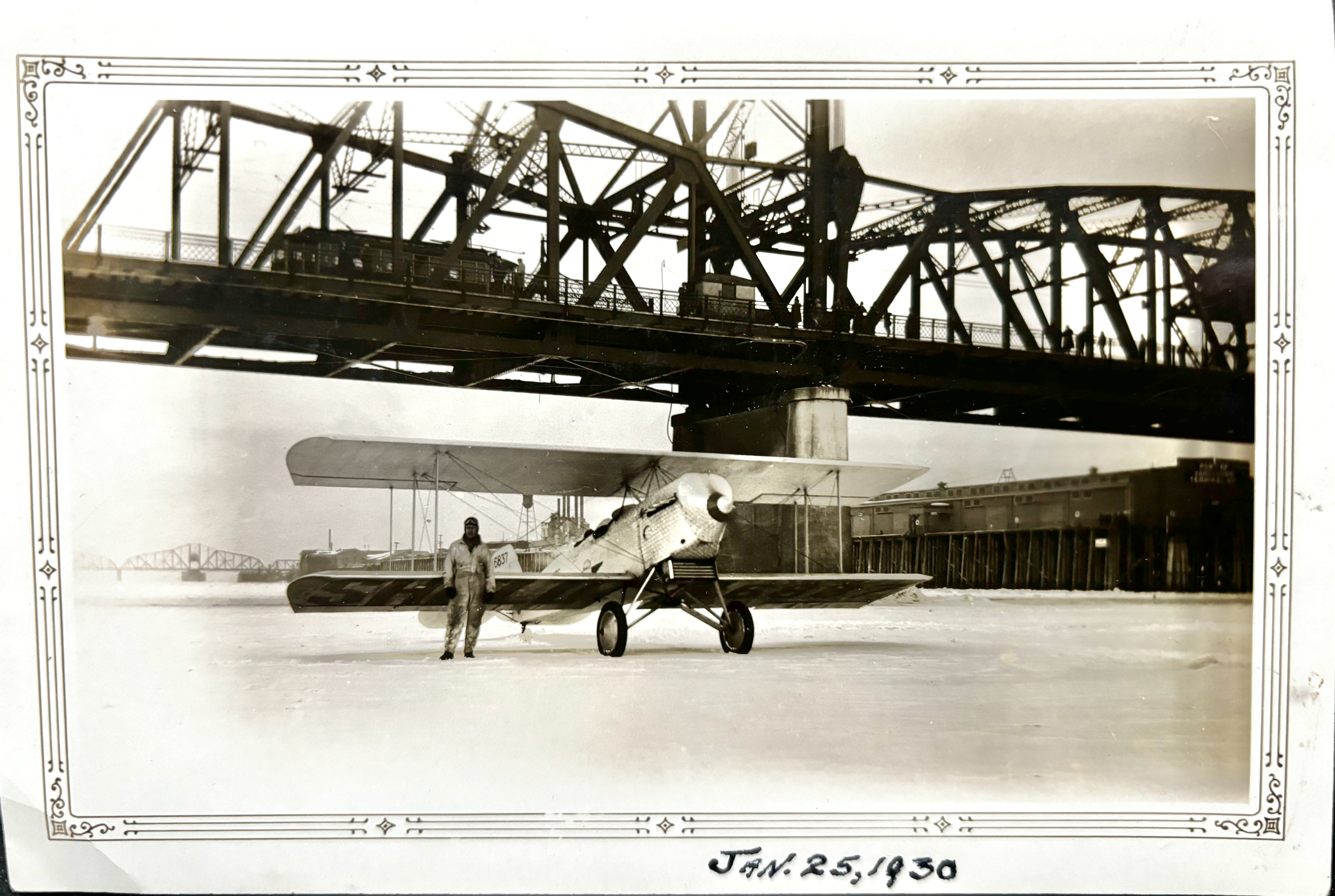
Here’s couple of winter images that led to a bit of old newspaper sleuthing. When we first saw this we thought: Broadway Bridge? But on second look, the setting and the structure didn’t seem right. Of note: the streetcar passing on the decks overhead. The date seemed important to the photographer and it turned out to be a helpful clue.
From the Oregon Journal, January 26, 1930.
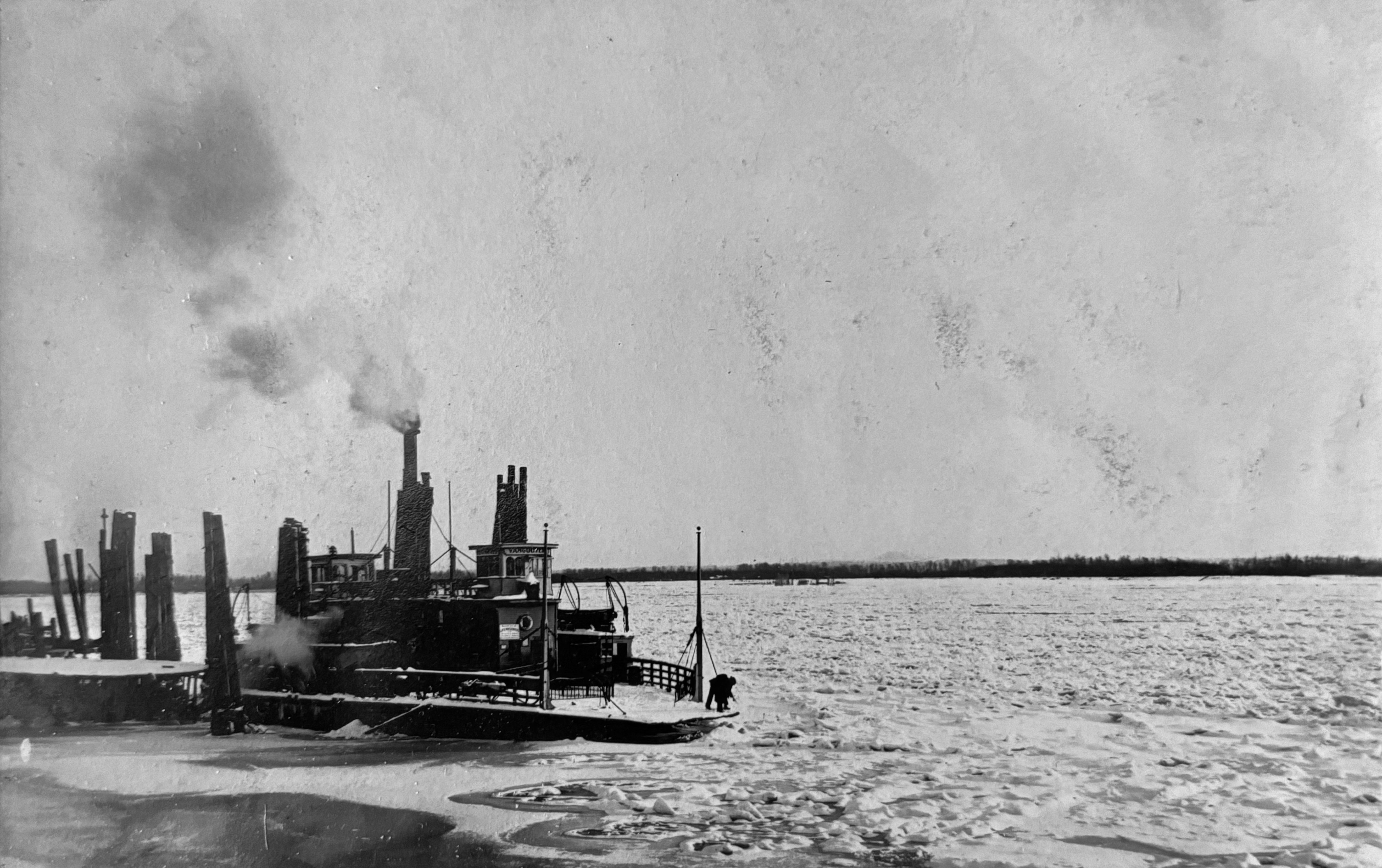
According to the Vancouver Columbian newspaper, it wasn’t so unusual for the Columbia River to freeze over completely, including the “Big Freeze” of 1909 that halted commerce, mail delivery and ferry traffic across the Columbia between Vancouver and Portland.
Hans von Homeyer captured this view of the ferry Vancouver and the frozen Columbia River in January 1909. With no bridge (it came along in 1917), and no ferry service to towns both upstream and downstream, frigid winter weather in January 1909 caused hardship throughout the frozen region.
Six glass plate negatives from 1908 retrieved from the basement of the von Homeyer house in Northeast Portland tell a story about a setting, home and family life that have become extinct but not forgotten.
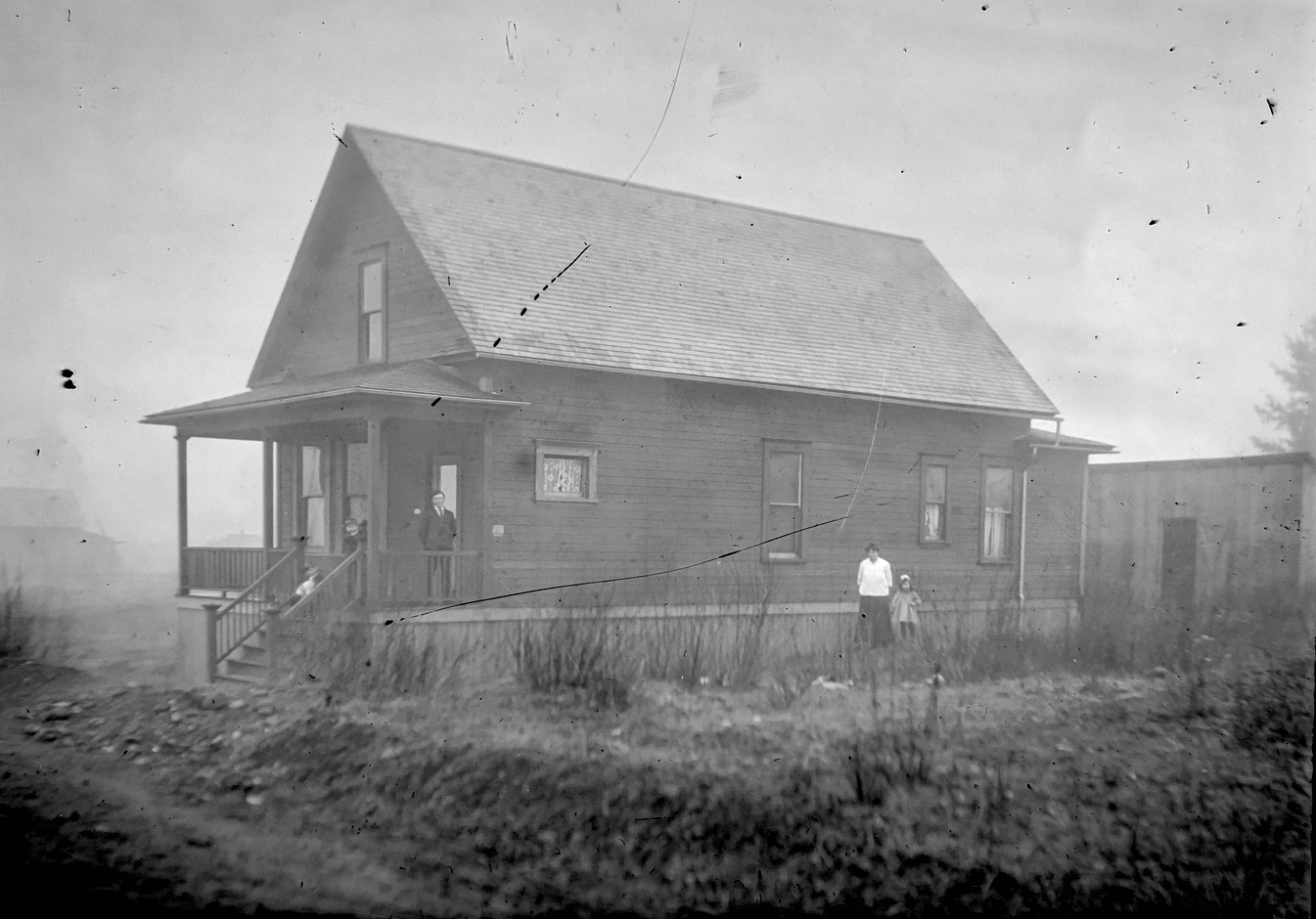
The first von Homeyer house in northeast Portland at 850 Going Street (today’s NE 27th and Going), from a glass plate negative. Hans O.S. von Homeyer on the roof with sons Hans W.S., and Irvin Erwin Frederick. At the back steps: Minnie and daughter Gretchen. View looking toward the northwest, about 1908.
The glass plates are some of the thousands of photos unearthed by new owners Michael and Jaylen Schmitt earlier this year as they prepared the house for overhaul and adaptive reuse. This winter and spring, we helped the Schmitts sort, organize and add context to the mountain of photos and documents that had accumulated in the house over the last century.
In May after careful review of each image, we sent more than 30 pounds of old photos “home” to the next generation of family members who had never seen many of these long-passed great aunts, uncles, grandparents and family scenes. Duplicates and some others (including the glass plates) went to an estate sale that helped clear out the house in May. A select few of the photos and documents will remain behind with the house going forward.
But these six are special, because they are so old and fragile, and because after some detective work, we now know what they depict.
The first time we saw them this winter, we knew they might be some of the most interesting images in the entire collection: they showed a young family’s connection with an old house–something always near to our hearts.
The von Homeyers at 850 Going: Erwin and Hans at left; Hans, Minnie and Gretchen on the front porch. Looking southwest about 1908.
They showed wide open spaces around the house, hinting at things to come.
The von Homeyers at 850 Going: Hans, Hans and Erwin on the porch; Minnie and Gretchen at the side. No sidewalks, dirt streets and wide open lots all around. Looking east-southeast about 1908.
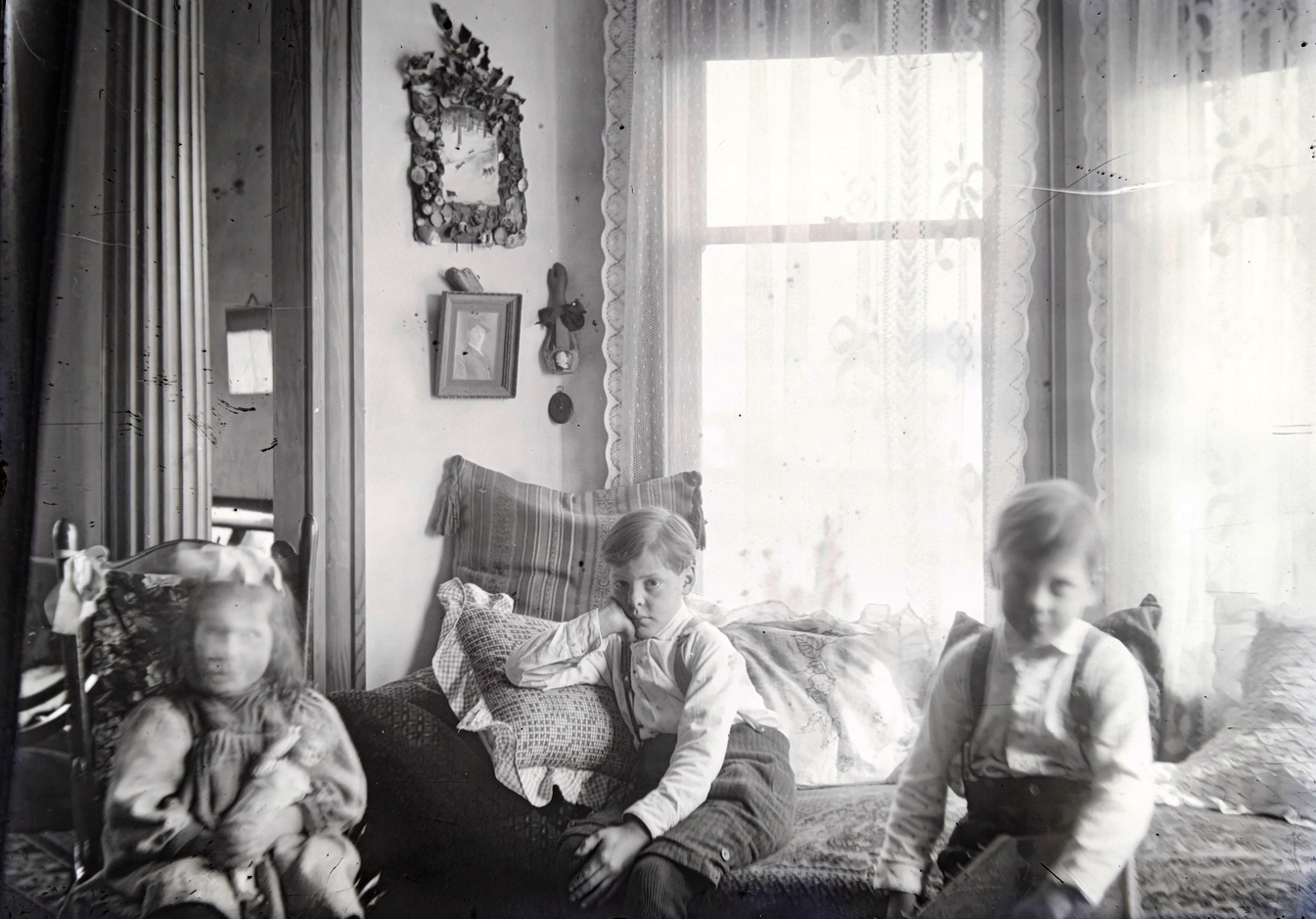
They showed the home’s interior, three children in the foreground, columns and windows behind.
Gretchen, Hans and Erwin at the bay window, 850 Going Street, about 1908.
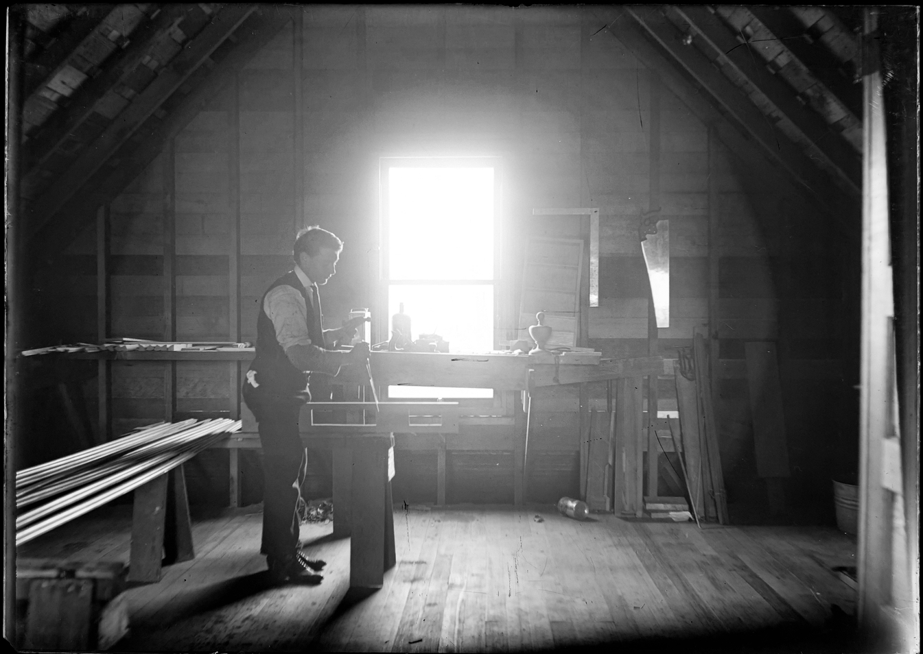
And they showed a builder at work upstairs. The backlighting from the second floor window makes it difficult to see, but the carpenter’s square, saw and plane behind him, hammer in hand, and the at-work stance of the human subject, come through clearly.
Hans von Homeyer at work, upstairs at 850 Going, about 1908.
As glass plate negatives go, they are a tad hard to read if you just pick them up for a quick look. Thick with emulsion, it takes a lot of light to reveal the negative image. Which might be one of the reasons why they survived the estate sale: people couldn’t tell what they were seeing.
We made prints and stared at them for a long time. Where is this place, we wondered.
Over the winter, as we continued looking at hundreds of family photos and began to recognize particular people and places, and as we researched the von Homeyer family story, a common thread began to tie some pieces together: this house.
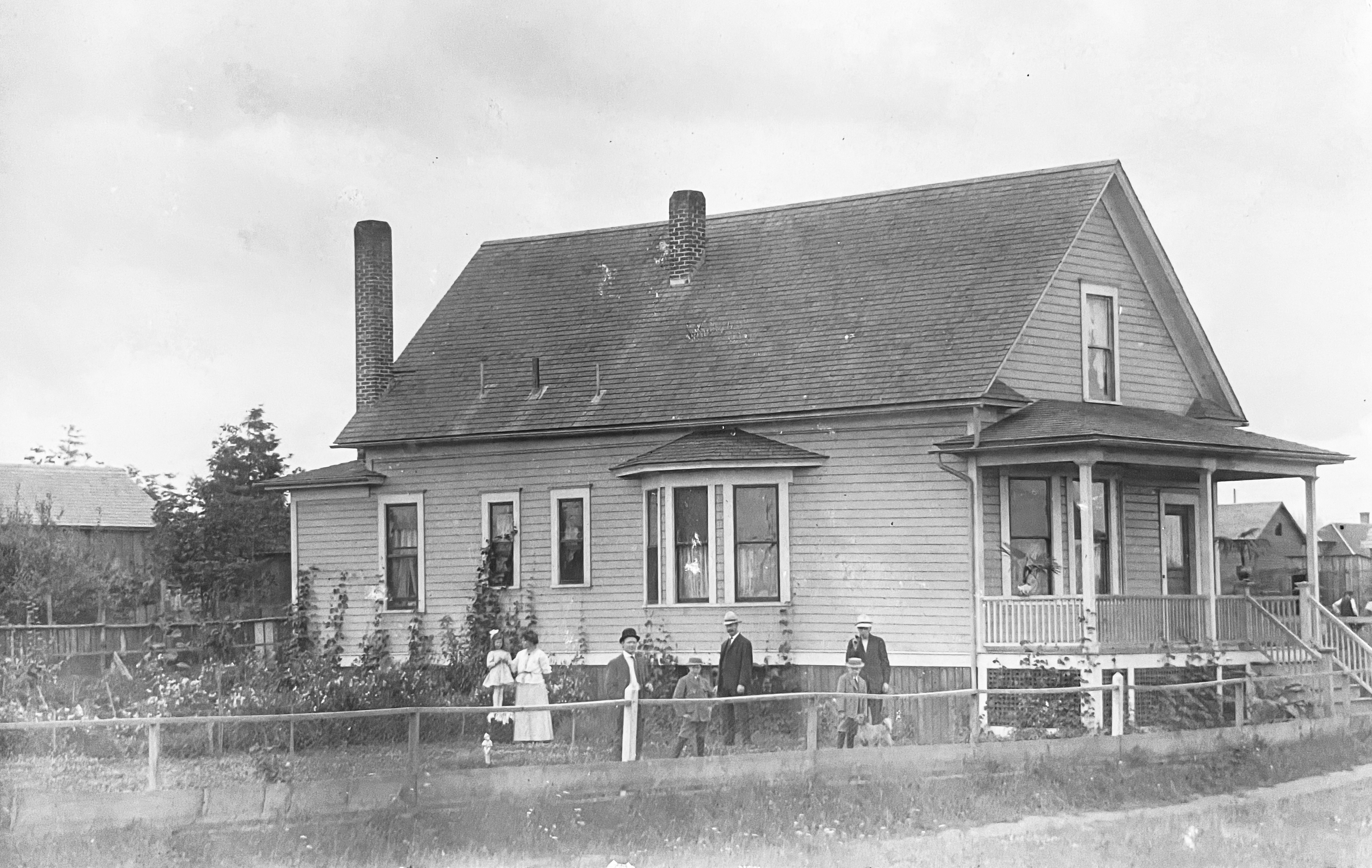
First, we found this paper image in one of the old photo albums. It’s a “Real Photo” postcard showing two generations of a family out front of a tidy house.
This Real Photo postcard was sent from Hans to brother-in-law Karl Tripp about 1909, looking southwest. Minnie and Gretchen at left; Hans center with Hans and Erwin; two unknown visitors. A few more nearby houses and a new coat of paint.
The glass negatives show a slightly earlier version of the house, before paint, less landscaped, a little rough around the edges, but definitely the same place. By 1909 and the postcard to Karl, the von Homeyer home at 850 Going was looking pretty tidy.
Do-it-yourself cards like this were first offered by Kodak in 1903 and almost immediately blew up in popularity as friends and families exchanged their own photos and brief greetings through the postal mail. An early and s l o w version of sharing photos and a few well chosen words across distance. Something families still like to do today. Here’s more about how Real Photo postcards transformed photography between 1905-1915.
This one was sent by the first Hans O.S. von Homeyer (1871-1942), father of Hans W.S. von Homeyer (1898-1969) who built the house at NE 24th and Mason, grandfather of the brothers Karl and Hans E. von Homeyer (1927-2002) who lived in the Mason Street house all their lives. Hans the elder sent the card to his brother-in-law Karl in Chicago, Minnie’s brother. The message on the back was in German which we can’t read, so we sent a picture of the almost undecipherable longhand script to our friends Christiane and Roland in Germany for quick translation. They wrote back immediately with the 110-plus year-old postcard greeting that made us smile:
“Dear Karl, we are all still alive and frisky. How are you? With best greetings from all of us to all of you.”
The card was signed “H. von Homeyer, 850 Going Street, Portland, Ore.” which of course also piqued our interest, knowing that Going Street makes its long east-west transit through today’s King, Vernon, Concordia and Cully neighborhoods. We’ve looked at enough old east-west addresses to know 850 was going to be about 27 blocks east of Martin Luther King Jr. Boulevard and would probably end up in the Elberta Addition.
If you search for that address in pastportland.com (which is one of the very best tools for converting between pre-address change addresses and today) it comes up empty. Plenty of numbers either side, but no 850.
We looked for 850 in the 1909 Sanborn Maps, but this block and several others nearby were still unbuilt brushy vacant lots with dirt roads scratched into the ground. Sanborns were used by fire insurance underwriters to gauge fire risk based on the presence of fire hydrants, distance from fire stations and types of construction materials and heating systems used by various buildings. But out near 27th and Going in 1909, there weren’t any buildings that needed insurance underwriting. So, it wasn’t mapped.
Next we began nosing around The Oregonian and the Oregon Journal, both of which are searchable by word going way back if you have a library card. News stories, letters to the editor from Hans and other mentions began turning up, confirming the von Homeyer’s presence there.
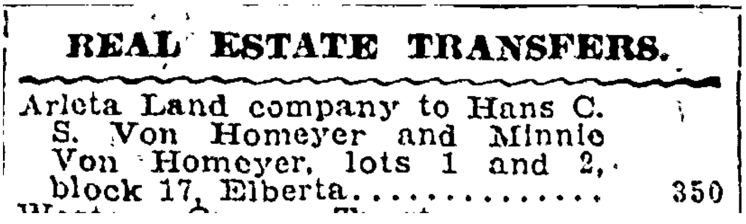
Then we found this buried in the real estate transaction list: Hans and Minnie buying a vacant lot in the Elberta Addition for $350 in late July 1907.
From The Oregonian, July 29, 1907
That gave us a lot and block number and a place to look. So we downloaded the Elberta plat from the Multnomah County Surveyor’s office, and began trial-and-error looking on Portlandmaps.com for block and lot details in that vicinity. We quickly found lots 1 & 2 of Block 17 today–the northeast corner of 27th and Going–but the pre-address-change address for that place says 848 and what’s there today doesn’t look anything like the postcard.
We began to note that after 1910, all references to 850 Going stop. Going, going gone. So how come 850 shows up in some news stories and on the postcard, but then disappears? We had a hunch.
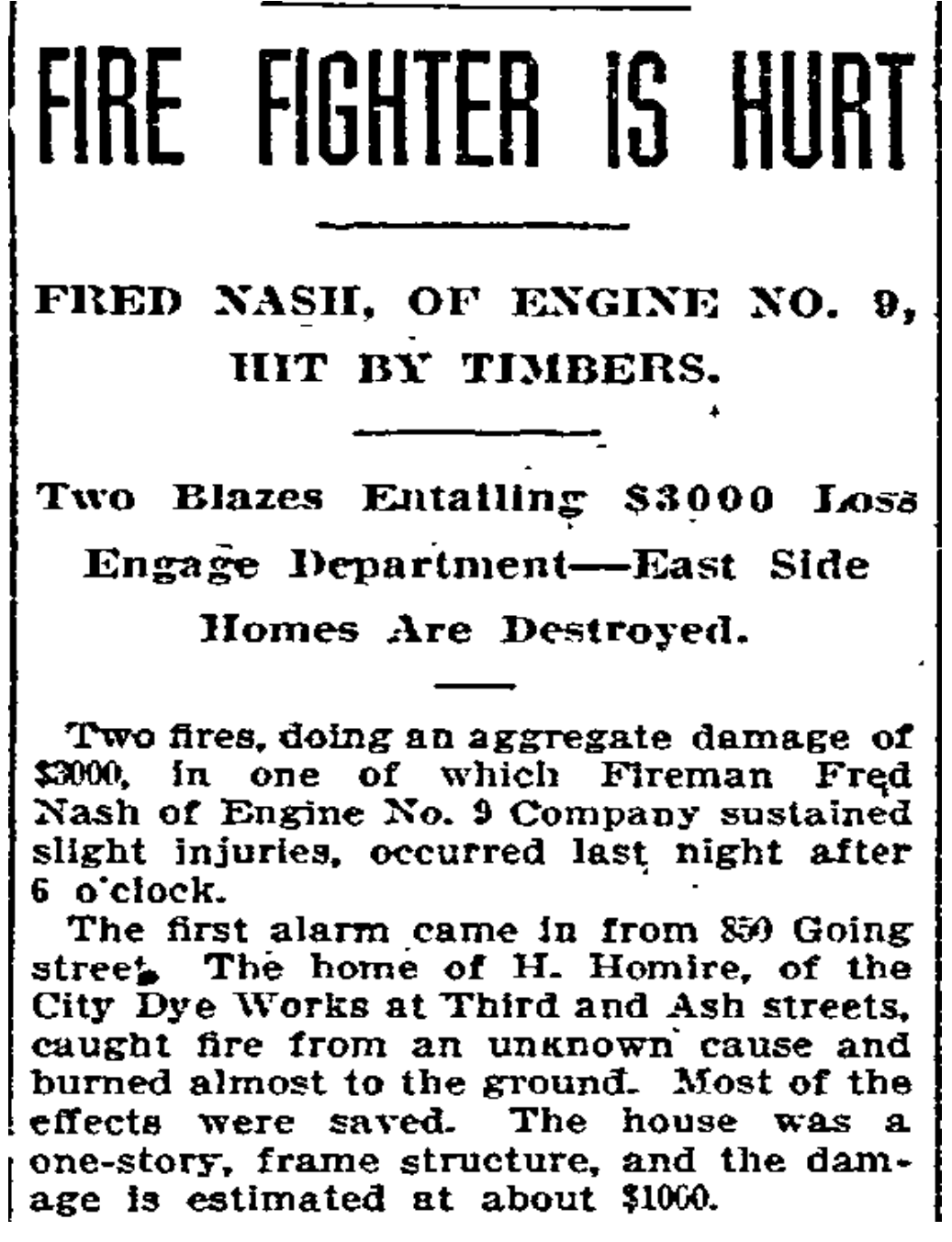
The next newspaper story we found made it clear:
From The Oregonian, September 20, 1909. Creative spelling.
Glancing back and forth between the post card picture and the glass plates, with the fire story in mind, the realization struck: the images on the old glass and the postcard print were showing the same house: the first von Homeyer home, built in 1907 after they arrived in Portland from Chicago. In September 1909, it burned to the ground.
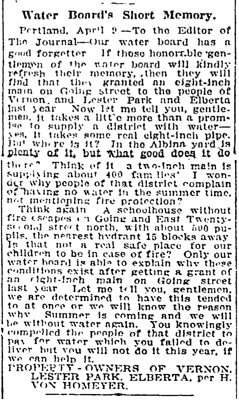
Eerily, Hans von Homeyer foreshadowed what might happen to their new home on Going Street. In a letter to the editor of the Oregon Journal the year before, signed on behalf of area residents, Hans gave voice to frustrations with the city about lack of water pressure in their part of the neighborhood, and worries about the fire safety of the huge wood-frame Vernon School just up the street, where their children attended.
From the Oregon Journal, April 13, 1908
In June 1911, Hans and Minnie sold Going Street and took up residence in a spacious Craftsman-style house on NE San Rafael just east of today’s Martin Luther King Jr. Boulevard. The kids were growing and so was their business. Later, the von Homeyers moved to Vancouver where their story continued.
Have a good look at the 1908 surroundings as you think about the corner of NE 27th and Going today. Just across the street is the former dry goods store. The streets were unpaved gravel, no curbs or sidewalks until 1913. On the property where the von Homeyer house stood, a new home was built: the late Queen Anne Victorian that stands today, known as the Going Queen. Today, that intersection is all concrete streets and sidewalks, topography leveled off, no vacant lots in sight.
Aside from the small miracle of their basic survival all these years is the reality these glass plate negatives somehow made it through the fire or were carried out of the burning house they depict: the news story reported “most of the effects were saved.”
For extra credit, the six glass plates also made it through the estate sale in May. No one was interested in them, so after the sale they made it to the dregs pile that Michael was going to have to deal with one way or another. When we learned this, we very happily rescued them from the dregs. Now they’re in a safe place.
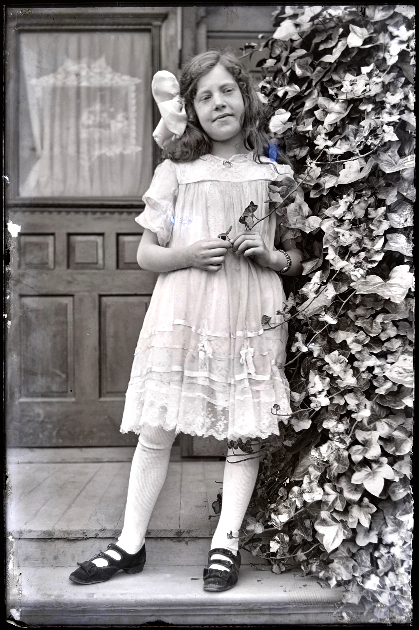
The last of the six glass plates–smaller in size, made a little bit later in a different location–may be the most wonderful, showing youngest sister Marguerita Anna “Gretchen” von Homeyer on a porch, bow in her hair, standing near an ivy-covered column, looking off toward the future. Probably taken in about 1913. She was eight years old.
Marguerita Anna “Gretchen” von Homeyer about 1913.
The von Homeyer house at 24th and Mason in Alameda has been a repository for many things over the last 100 years, some of which we’ve mentioned in past posts: cars, board games, clothing, tools, documents, sheet music. The estate sale in May presented an astounding cornucopia of items.
Among the many treasures yielded up by that packed house were hundreds and hundreds of photos, some of which date back more than 120 years, offering views of Portland—and of life in general—which are worthy of note, many which would be personally important to family members. If we could find them.
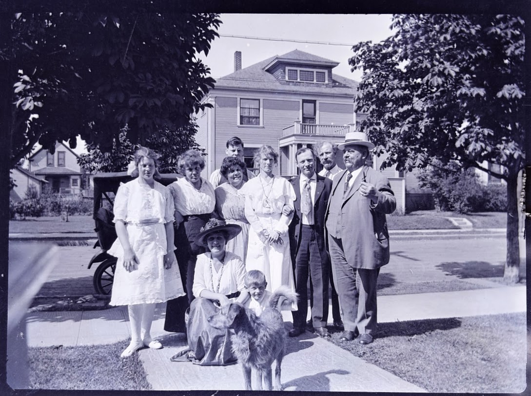
The von Homeyer family in front of their rented home on NE San Rafael just east of Martin Luther King Jr. Boulevard, about 1915. Hans von Homeyer standing in the back row, his father Hans in the back at far right. About 12 years later, Hans and Frances would name their eldest son Hans…who grew up in the Alameda house.The house in the background of this photo still stands today, though the family home on the south side of San Rafael has been razed.
Some of the photos led us down faint rabbit trails seeking deeper insight, like the glass negatives of a family in its new house surrounded by wide-open fields, or the daredevil pilot who landed his plane on the ice beneath the span of a bridge, or the proud employees and their shiny fleet of delivery vehicles parked out front of the family business. We’ve figured out these stories and will share them in upcoming posts.
AH readers know we love photographs like this and have made it our practice and passion to connect past and present through old photos. Check out the Photo Detective and Old Photos categories here and you’ll see what we mean.
Other 100-plus-year-old photos revealed places still standing and recognizable amid utterly different human landscapes:
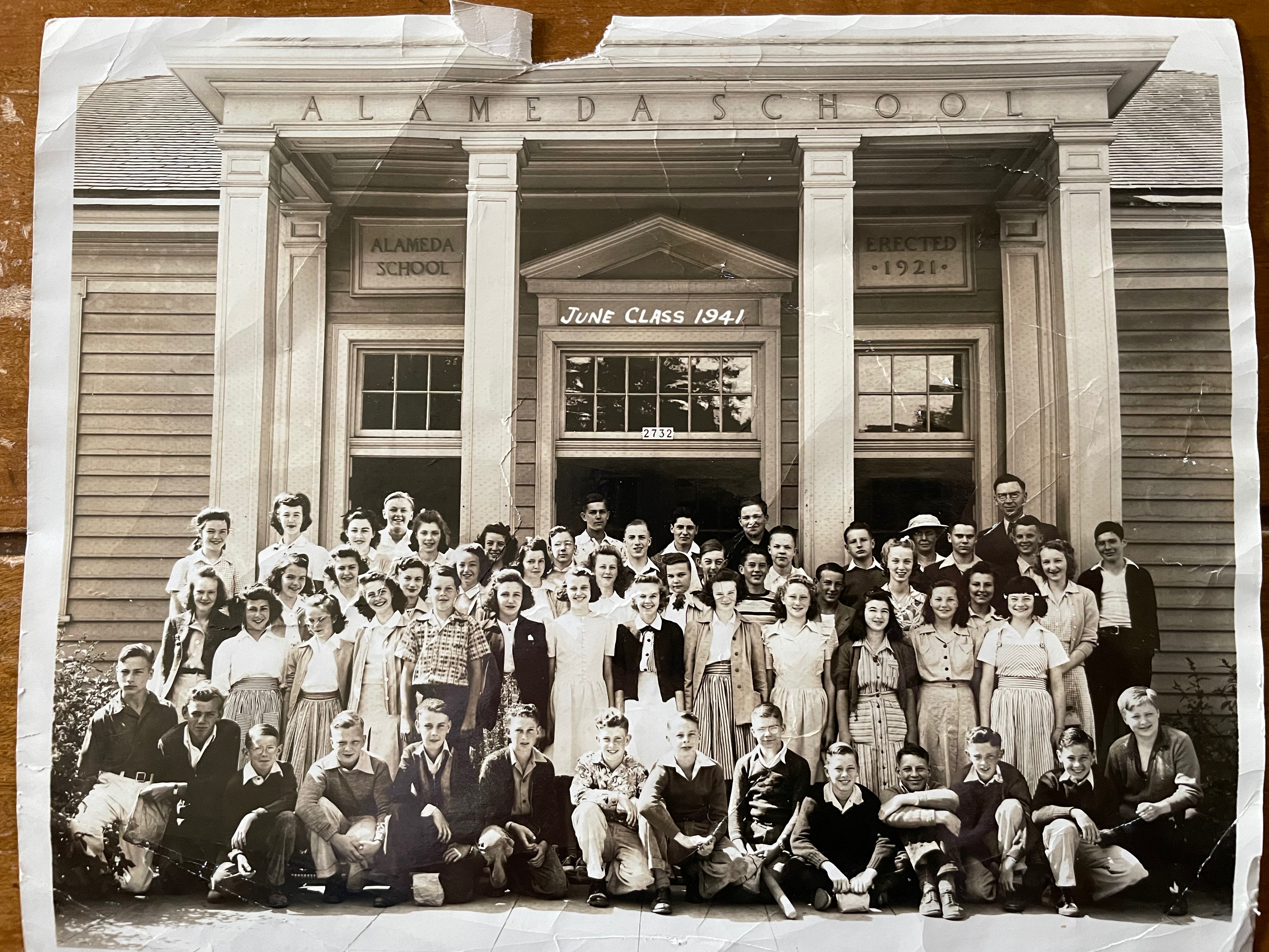
Young Hans von Homeyer’s 8th grade graduation from Alameda School, June 1941 (he’s at bottom right).
This winter and spring, as the busy new owners of the von Homeyer house sorted through barely accessible pathways in the crammed house, Michael would call us to come pick up another bag and another box and another bigger box of photos and items they had unearthed that we were helping him sort. Beautiful family photos of special moments that had once meant a great deal to someone. And here they were without context, names, locations or anyone to try to understand them.
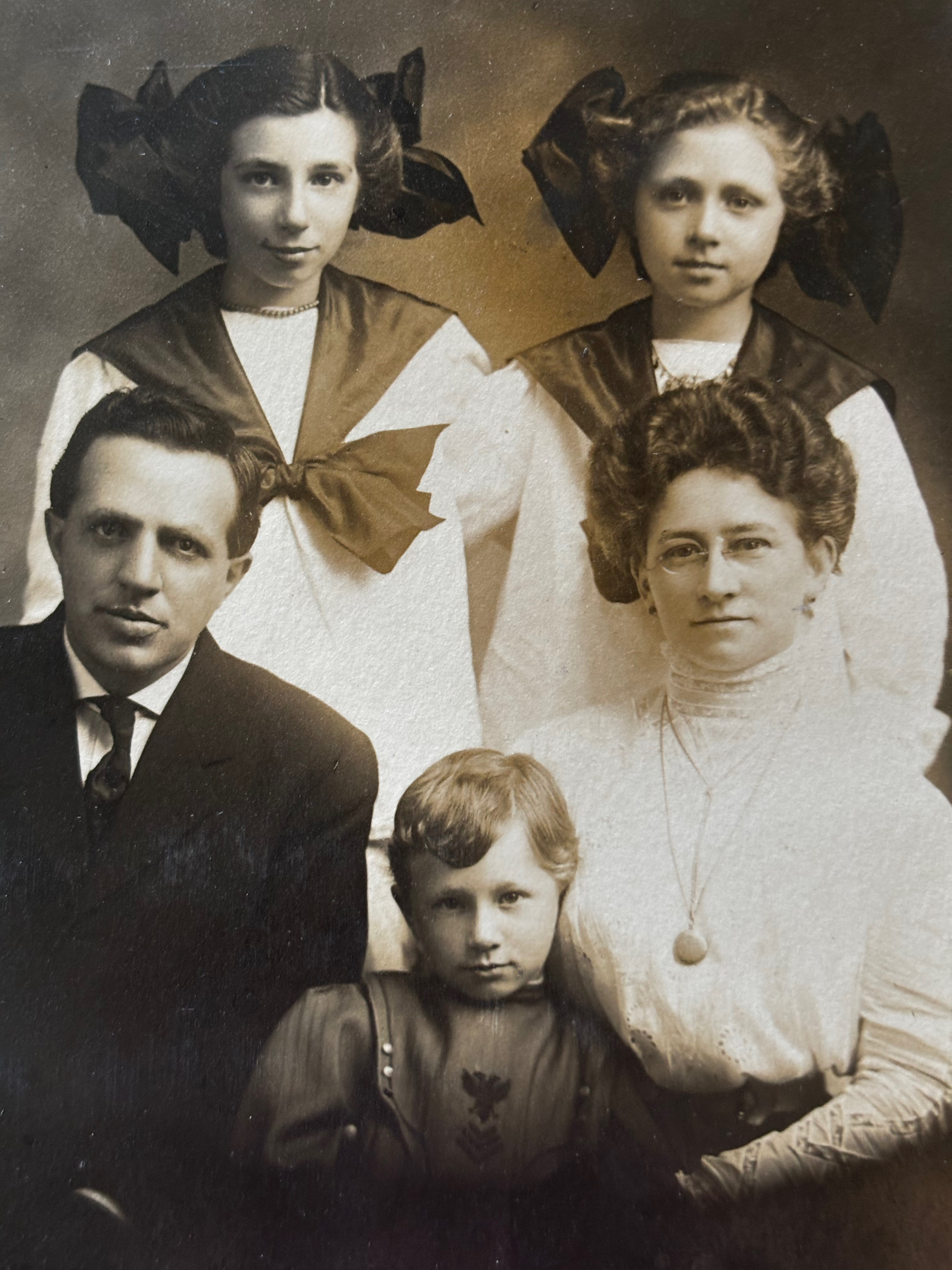
The Westhoff family of Vancouver about 1910
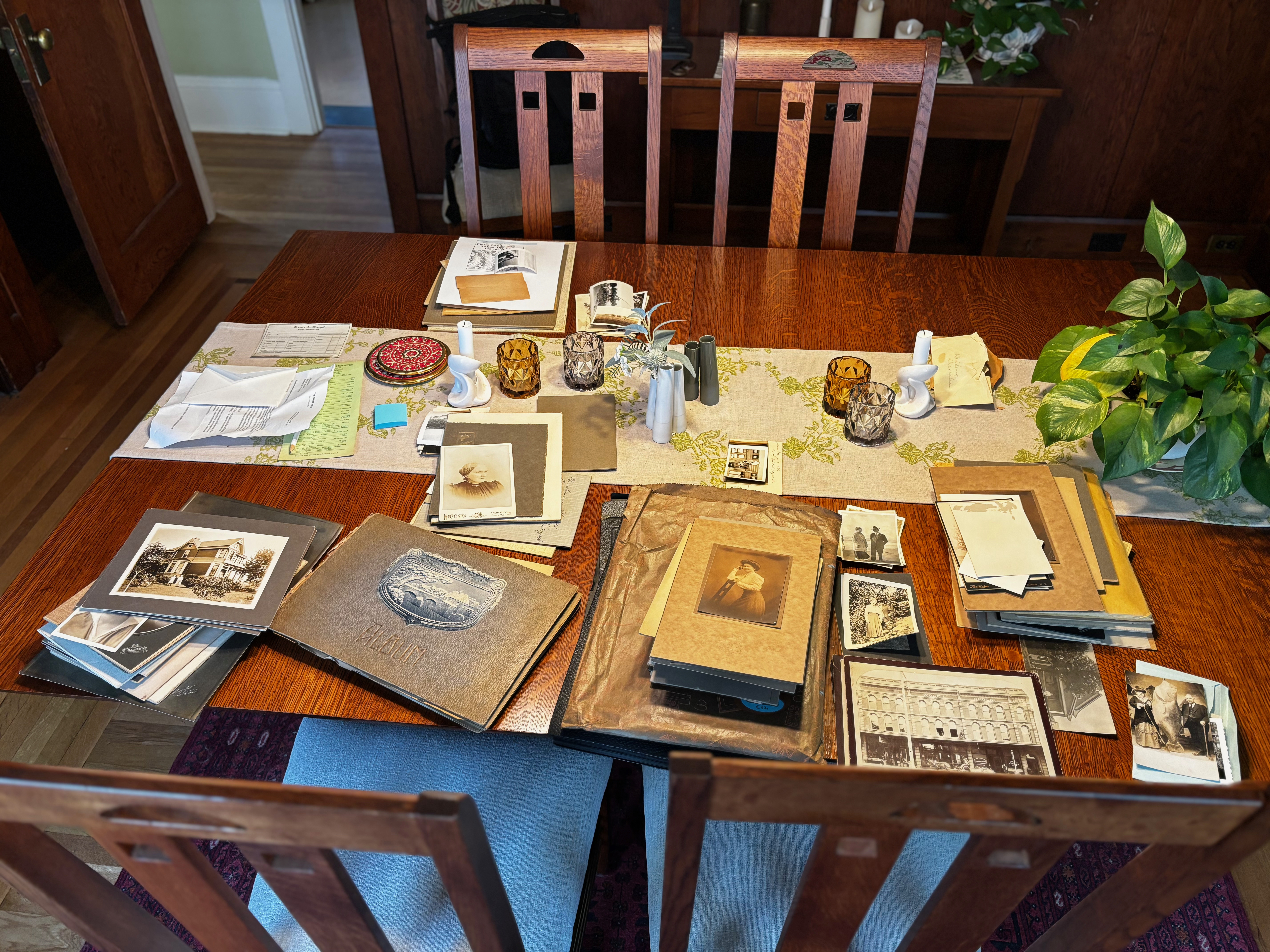
We spread them out on our dining room table and began to look back at them and get to know the faces, their surroundings and the visible family relationships. Next, we sorted by era, location and family group. Handy genealogy tools like censuses, marriage, birth and death certificates—combined with trusty other tools like building permits, old maps, newspapers, and city directories—helped us piece together a visual narrative that followed specific family lines and chronologies. We felt like we were getting to know these people.
When we found houses or buildings we thought might still exist, we tracked them down, finding and then decoding addresses from Portland’s former street addressing system. We even knocked on a few front doors in the Portland area to pass along hundred-year-old views to surprised current residents (that was fun).
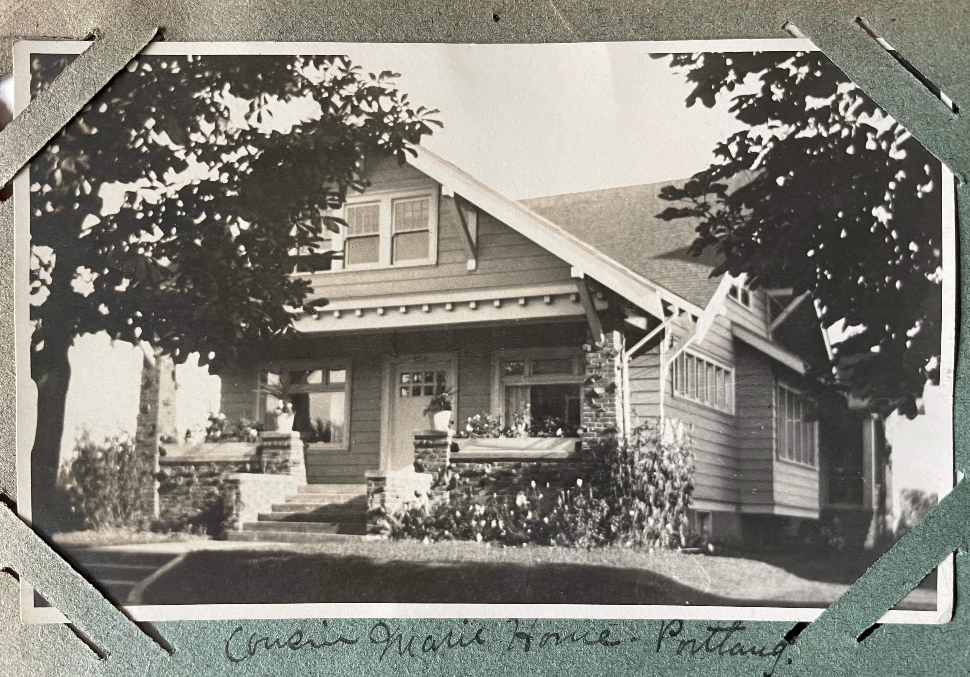
4246 NE Flanders, home of Frances’s cousin, about 1921. After figuring out its location, we gave this and several other photos to the current residents.
One of the humbling privileges of research like this is to watch as families grow and change before your eyes. Energetic, fresh newlyweds become grandparents. Young children gradually emerge as adults and then they are the elders. We’ve often experienced this compression of time while researching census and other paper documents, but with family photos it’s so much more impactful, reminding us of the brief time we actually have with each other. Blink. Change is our constant companion.
Gradually this spring we became visually acquainted with the people who inhabited the von Homeyer house, and their extended and earlier family members, many who lived in Vancouver. Two curated collections began to emerge from hundreds of beautiful portraits and heirloom photos of Frances Westhoff von Homeyer’s parents, siblings, grandparents, and of Hans’s immigrant parents, his siblings, and their businesses.
After multiple unsuccessful attempts at finding extended family members who might be interested in receiving these photos, a lucky break revealed contact information for two of Frances’s nieces, now both in their 80s. Their dad, grandparents, great grandparents and aunts and uncles—and so many family moments—were here on our dining room table; photos that hadn’t been seen or appreciated by family members for decades.
After a few phone conversations with the nieces–and the blessing and encouragement of new homeowners Michael and Jaylen Schmitt—we packaged up the hundreds of Westhoff family photos (almost 30 pounds) and shipped them off to the elderly nieces. Delighted emails and letters followed as they became reacquainted with faces they hadn’t looked into for a lifetime–many photos they had never seen–including pictures of their long-passed father as a boy.
A similar but slightly smaller collection of photos from the von Homeyer side of the family still awaits placement. Because brothers young Hans and Karl never had children, and the family tree branches on their father’s side appear to be short or no longer in existence, these photos may remain solely as artifacts from their time. A smaller collection with views of the house and neighborhood will join the architectural drawings and other documents that stay with the house.
Note to self about old photos in your collection: talk with people now who know those elder faces and places. Write gently in pencil on the backs of those photos. Scan and share the images with other family members. As time passes, the family landscape and the surroundings we know so well today will evolve, landing these photos at the far edge or beyond understanding and recognition. Like the collections unearthed from the von Homeyer house, today’s ubiquitous family photos and snapshots may well be precious messengers across time for future generations.
As Portland slowly rebounded from the Great Depression of the early 1930s and interest rekindled in Portland residential real estate, the stage was set for a new era at NE 42nd and Killingsworth. Open lands were available for development, subdivisions were platted with buildable lots ready to go, and new infrastructure was on the way in the form of paved roads and big plans for the new Portland Airport. A small wood-frame general store had been built in the late 1920s at what was then the quiet rural crossroads, and other nearby mom-and-pop stores were opening to meet the needs of surrounding residents.
By 1951, the corner was home to multiple gas stations, a barber shop, a cleaners, an ice cream shop and a café. The small wood frame building on the northeast corner had become the Publix Market, operated by Cliff and Mary Tadakuma. Here’s a look:
1951 Looking Northwest
Looking to the northwest at the intersection of NE 42nd and Killingsworth about 1951. The Publix Market is at the northeast corner, on the right. The Lyle Sumner service station is on the Northwest corner. Note that the intersection is not signaled. Photo courtesy of Joyce Tadakuma Gee.
Before the war, Portland had a thriving population of immigrant and first-generation Japanese families who were integrated into all aspects of civic life. In early 1942, following the attack on Pearl Harbor and declaration of war, Japanese Americans were forcibly removed from most West Coast cities and relocated to internment camps in remote inland areas of the American West. The federal policy fractured families physically and emotionally, and resulted in significant economic losses for Japanese-Americans who owned businesses and property.
As families were loaded into buses and trains during the “evacuation,” heart-breaking decisions were made about the disposition of lands and businesses. Beginning in the 1930s, the Shiogi family had operated a market known as “Publix Market” at the corner of North Killingsworth and Gay Street in North Portland (the storefront that today houses Milk Glass Market, 2150 N. Killingsworth). When the Shiogis were removed to the Minidoka Internment Camp in Idaho, they “gave” their store to neighbors for safe-keeping.
In the fall of 1945, upon returning after the war, the family attempted to re-open the store but found anti-Japanese sentiment in Portland to be too strong. Younger members of the family—daughter Mary and her husband Cliff Tadakuma—who had endured the internment experience only to be discriminated against at home in Portland, moved to Hawaii for several years in search of a more hospitable environment. Mary found work as a housekeeper. Cliff became a gardener on a large estate.
In 1950, Mary and Cliff Tadakuma—with their young daughter Joyce who had been born at Minidoka—returned to Portland from Hawaii and decided to try again to reopen Publix Market, but this time in a different location farther out Killingsworth, in northeast Portland.
Mary had grown up in Portland, a first generation Japanese-American. Cliff had grown up in Maui and graduated from Oregon State University with a degree in chemical engineering (and where the two had met). While their interests and expertise were not necessarily in running a small grocery store, it was a better option than housekeeping and gardening when they returned to Portland.
The couple leased the old wood frame building at the northeast corner of NE 42nd and Killingsworth. The store was adjacent to a densely populated trailer court established during the booming war years, and the surrounding residential neighborhood was growing as well. With the help of Mary’s parents Lori and Hood Shiogi who had run the market when it was located in North Portland, Mary and Cliff set about re-establishing Publix Market.
Daughter Joyce Tadakuma Gee was six years old at the time and recalls that her family lived in the back of the store. Behind the shelves and retail area were two small bedrooms, a bathroom a living room and a small kitchen. Joyce—who is a long-time Portland resident—attended nearby Whitaker Elementary School, located on Columbia Boulevard. “I remember being so envious of classmates of mine who had ‘real’ homes to live in,” she recalled when interviewed in 2020.
Neighbor Doris Woolley grew up on Jarrett Street just north of Publix Market, and remembered that everyone referred to the store simply as “Cliff and Mary’s.” Doris—who passed away in 2020 at age 92—recalled that all of the residents of the trailer park and neighbors north of Killingsworth were loyal to Cliff and Mary and would only shop at Publix Market, even though there were two other small markets nearby.
“It was a great store and they had pretty much everything you wanted,” Woolley recalled. “Plus, they would let you run an account. In those days a lot of people would charge their groceries during the week and pay for them once they got their paychecks at the end of each week.”
Asked about her recollections of Cliff and Mary’s Japanese American origins and any tensions during the post-war years, Woolley remembered only that everyone liked Cliff and Mary. “They were very kind to everyone.”
Mary Tadakuma died in 1954. Cliff remarried and moved with daughter Joyce to Hood River, where he ran a grocery market until his death in 1978.
1958 Looking North
This 1958 photo (courtesy of City of Portland Archives, a2005-001-984) looks north on NE 42nd just south of Killingsworth. Publix Market is gone, replaced by the Panarama, a liquidation store. The Chevron service station across 42nd to the west has changed hands since the earlier photo and was being operated by Rod Martin. Behind the Panarama Market was the parking lot and sign for the brand-new Safeway store. The intersection was controlled by stop signs facing NE 42nd Avenue.
The white clapboard market building was built about 1927 and was initially operated as a grocery store by Bill and Jennie Batson. Panrama survived the 1957 opening of Safeway, but by 1961 the building had been demolished and replaced by a parking lot and service station.
Safeway Opens in January 1957
A combination of changes in the grocery business—with tendencies to larger chain stores—and an increasing population and market made the corner a natural for the Safeway store, built on the site of what had been the trailer park and small grocery store in the 1940s-1950s.
The store opened in January 1957 as part of a three-store opening blitz in the Portland area, as described in this full page ad from The Oregonian on January 10 1957.
1964 siting of John Adams High School
Construction of John Adams High School just southeast of Fernhill Park in the mid-1960s caused quite a stir and protest from the neighborhood. More than 200 angry neighbors turned out at a Portland School Board meeting on September 14, 1964 to share their disbelief that the School Board would demolish and relocate more than two dozen homes, three duplexes, a local greenhouse/nursery known as Knapps and a PGE substation to make room for the school.
From The Oregonian, September 3, 1964. The homes and businesses inside the dotted line were demolished or relocated to make room for John Adams High School.
From the Oregon Journal, September 3, 1964. Greenhouses for Knapp’s Nursery on NE Simpson are visible in the photo to the left, which looks north on NE 42nd.
The emotion and sense of loss in the letters and petitions submitted to the school board make for tough reading. Despite this strenuous protest, demolition went ahead, construction followed, and John Adams High School opened in September 1969.
From the Oregon Journal, September 15, 1964
A dozen years later, when high school enrollment dropped in the early 1980s, the building was repurposed as a middle school and operated for another 18 years before being closed in 2000 due to health concerns about mold and radon gas. The building sat empty and was frequently vandalized until being torn down in 2006 leaving the large open space south of the track. Newcomers to the area today might not even know that vacant piece of ground south of the track was once a high school and middle school.
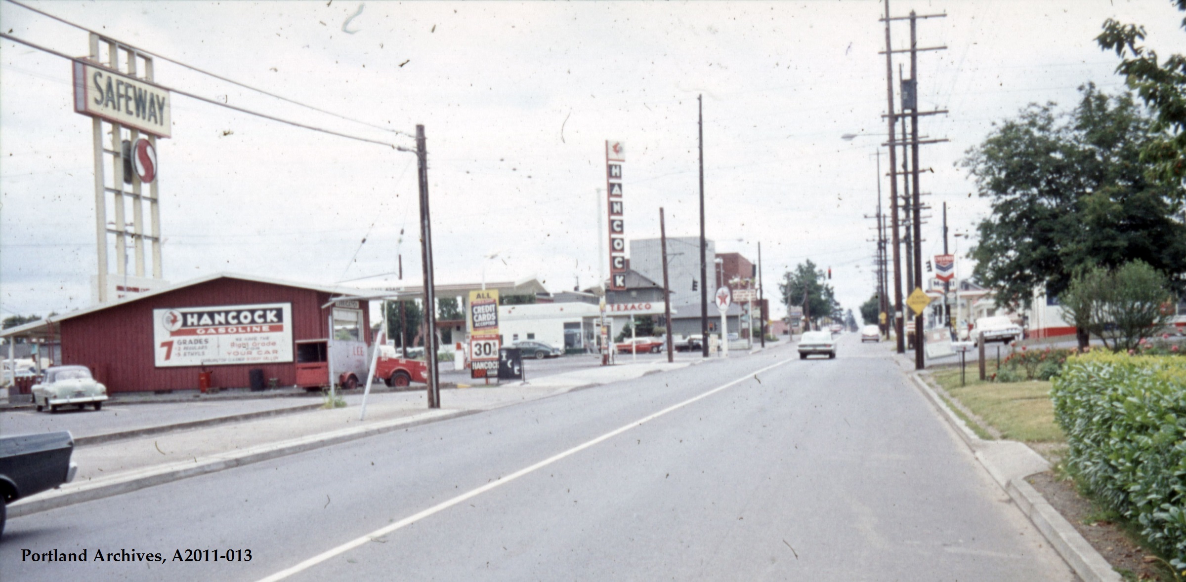
1965 Looking South
This view from 1965 looks south along NE 42nd Avenue. The tall buildings in the background are the relatively new St. Charles Church. The intersection has a traffic signal, and each corner features a different gas station: Texaco, Hancock, Mobil and Chevron. The Hancock building stands about where the Publix Market building once stood. The Safeway sign looms large over the intersection. Photo courtesy Portland City Archives, a2011-013.
Safeway operated in this location until about 1972, when the property was acquired by Portland Community College and the building remodeled to become a workforce training facility. In 2024, a completely new PCC building at the corner is now the Portland Metropolitan Workforce Training Center. And construction is underway just to the east on an affordable housing development managed by Home Forward that will include 84 units.
From open space that once provided wildlife habitat and material needs for Indigenous people; to homestead and farm fields that supplied a growing population of newcomers; to park land, school grounds, green houses, family homes and retail; and today affordable housing, workforce development and some great restaurants; this place has continued to evolve, layer upon layer of history and of life.
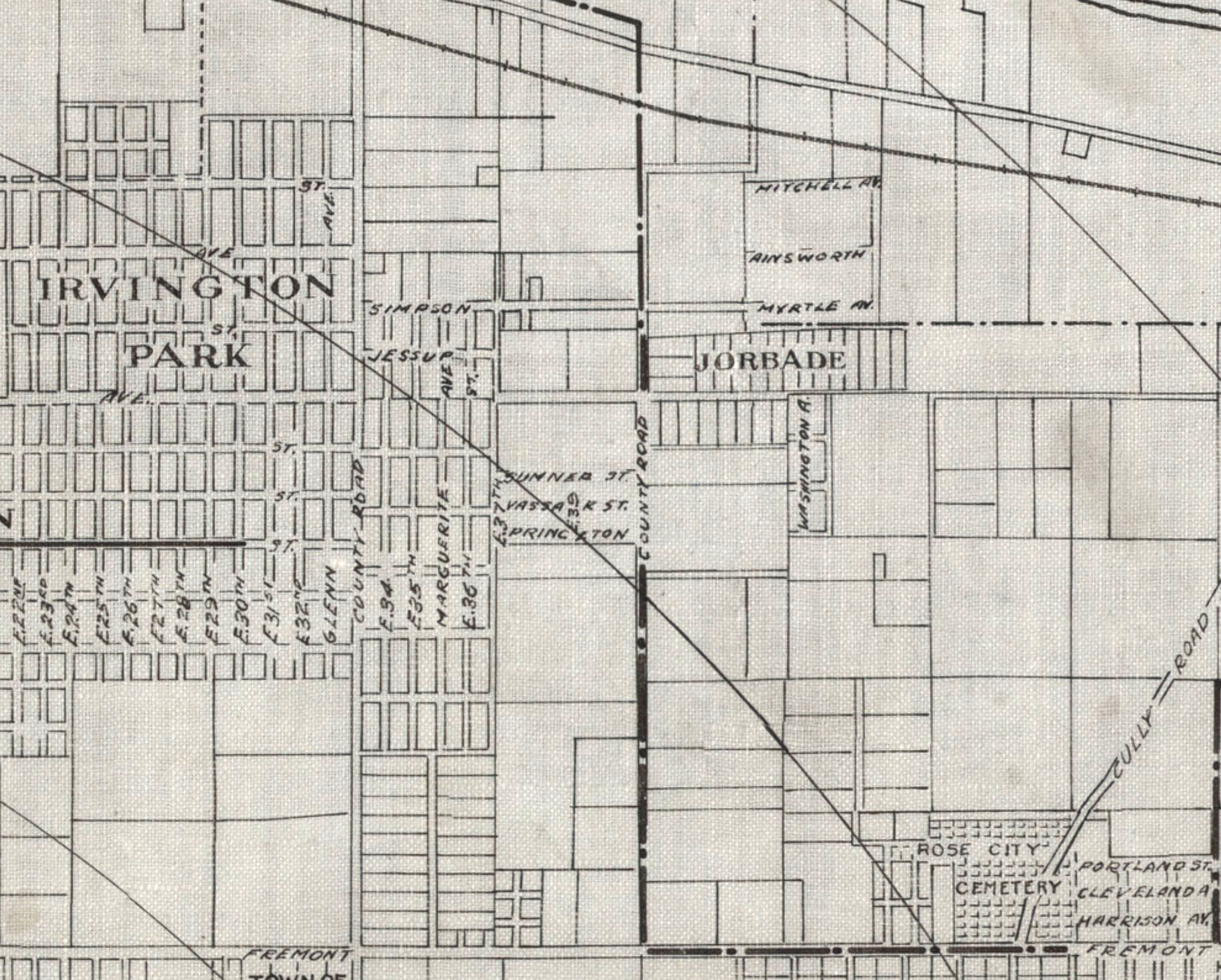
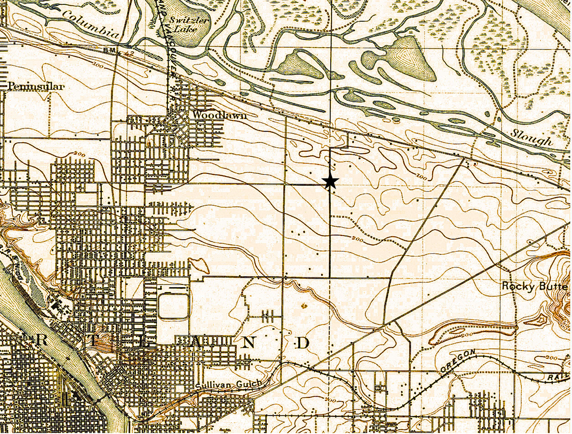
Detail from a 1908 Portland Railway, Light and Power Map showing the vicinity of 42nd and Killingsworth, in the center of the image. The Jorbade subdivision was platted at the intersection in 1908. The western “County Road” is today’s NE 33rd. The eastern “County Road” is NE 42nd. Rose City Cemetery appears in lower right (note that Cully passes through the cemetery).The cross-hatch lines indicate mile increments distant from downtown.TheIrvington Park plat is part of today’s Concordia neighborhood.The Alameda Park Addition had not yet been platted and is shown as open fields.
Continuing from our first installment exploring the layers of history at NE 42nd and Killingsworth…
The early years of the 20th Century brought a sea change to the Portland area: dramatic growth in population and a spike in residential and commercial construction that followed; a steady increase in the area’s rail and river shipping and port activity; extension of an interconnected electrified streetcar system; and arrival of the automobile. The 1905 Lewis and Clark Centennial Exposition drew national and international attention to Portland, attracted business and new residents, and set Portland on a growth curve that would remake the region.
During those early years, the vicinity of NE 42nd and Killingsworth was still a rural crossroads. Killingsworth (which was gravel) didn’t go farther east: it dead-ended into NE 42nd Avenue, which was known only as “County Road” up until the late 19-teens. Maps show the area much like the 1897 USGS map until the second decade: fields all around and less than 30 buildings—many of them barns—within a one-mile radius of the intersection.
But real estate speculators and some landowners could see the writing on the wall. Streetcar lines were working their way east, and new subdivisions and commercial areas were being planned and built. By 1912, a high volume of residential construction was underway in nearby Alameda, Beaumont and Rose City, all of which had been similar open fields and dirt roads.
Open lands are platted for homes, setting the stage for the area we know today
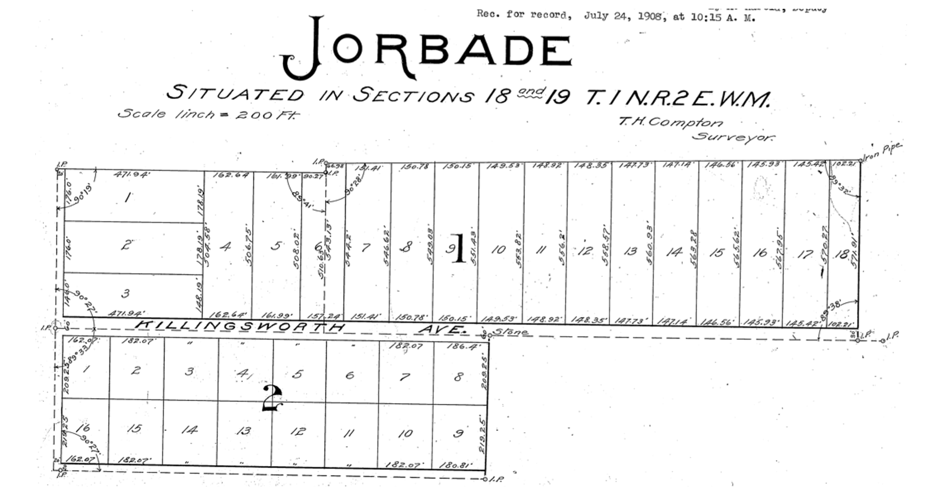
By 1909, real estate speculators Commodore Perry Jordan and Theodore August Garbade had purchased a portion of the old Isaac and MaryAnn Rennison Donation Land Claim at the intersection of today’s NE 42nd and Killingsworth. The two planned to sell residential building lots from what had been open farm land. Jordan and Garbade called their planned suburb “Jorbade,” and filed this plat with Multnomah County. The western edge of the plat is NE 42nd Avenue. Important to note that Killingsworth wouldn’t go through for at least 10 more years. These lots would be just that–vacant lots–for many more years.
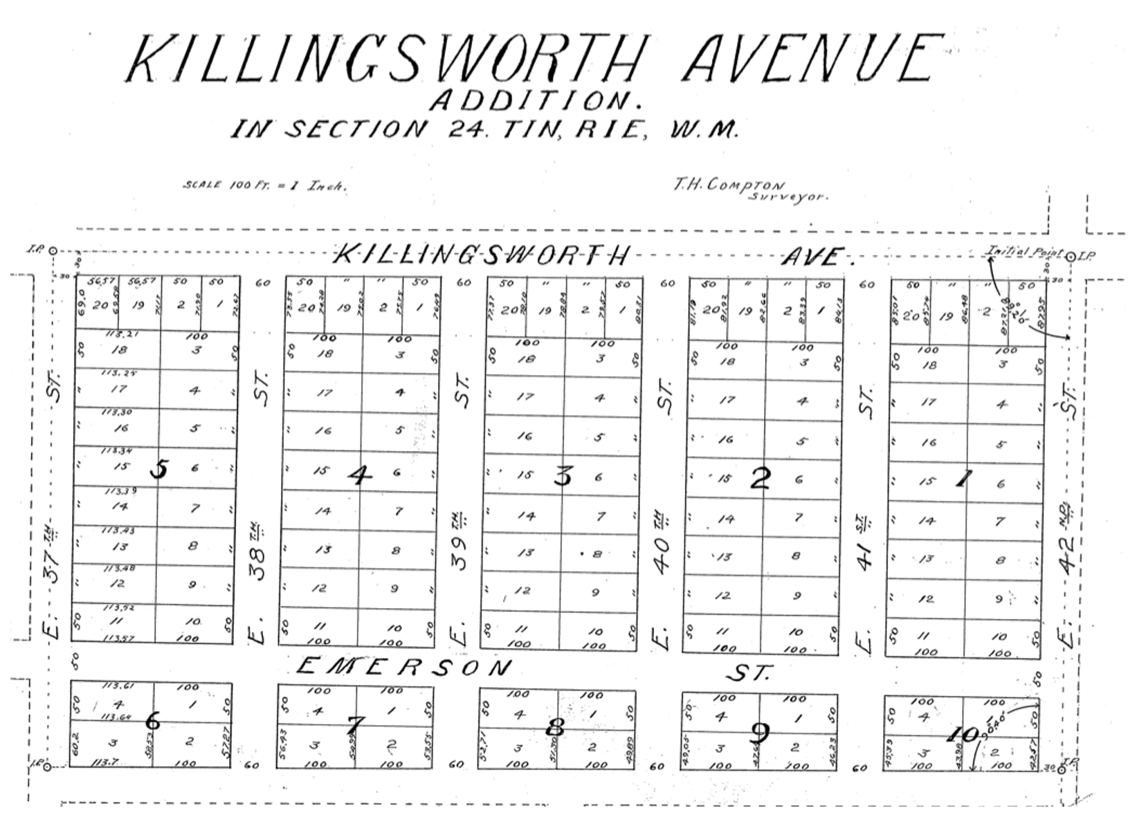
A few years later Jordan and Garbade acquired the lands on the opposite corner and were ready to convert them too from open fields to a subdivision. In 1911 they platted the Killingsworth Avenue Addition, from Killingsworth south beyond Emerson, between NE 37th and NE 42nd.
A bit farther west, local resident and real estate speculator John D. Kennedy was a few steps ahead of Jordan and Garbade. He had bought old homestead lands in 1880 believing that Portland would one day expand east; in 1890 he platted the Kennedy Addition, while this area was still part of its own town: East Portland. Here’s a detailed look at Kennedy and his adjacent nearby lands.
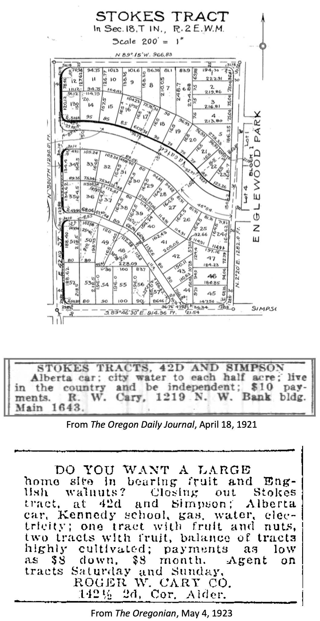
The Stokes Tract followed Jorbade and the Killingsworth Addition in 1920, north of Killingsworth and east of 42nd, establishing the graceful arc of Ainsworth and Simpson Court. This area retained a rural feel: “Live in the country and be independent” reads the advertisement.
Other subdivisions followed including tiny View Park in 1923, on the north side of Killingsworth between 36th and 40th:
Interest in these planned subdivisions was not particularly strong until the late 1930s: their distance from downtown, their presence outside the city limits and about a mile walk from the nearest streetcar line (despite what the advertisement said about being on a 5 cent fare line); their rural nature including gravel roads and surrounding fields and orchards may have made them less attractive, even if the prices were lower. But as Portland continued to expand, and the automobile became more prevalent, would-be homeowners were ready to buy and build.
Classified advertisements for properties adjacent to the intersection report a variety of crops growing at the time: orchards of Bing, Lambert and Royal Anne cherries; English walnuts; Bartlett pears; prunes and plums; apples; rows of strawberries and raspberries.
Often referred to as “truck farms” because the produce was trucked to market (and some of it was sold out of the back of trucks at busy intersections and small markets around town), these surrounding fields produced fruit and vegetables for Portland households. One farm near the corner of what is today’s NE 41st and Holman was owned and run by a Japanese immigrant family, as were others in the area. During WWII, Japanese farming families across the Pacific Northwest were removed from their land and placed in internment camps in southeast Oregon, central California, Idaho, Utah, Wyoming and Colorado.
Portland Air Base leads to new roads and new residents
By 1935 air freight and airline passenger traffic had overwhelmed Portland’s first airport—located on Swan Island—and the city spent $300,000 to purchase a 700-acre site adjacent to the Columbia River where today’s Portland International Airport resides. With a grant from the Works Progress Administration, workers drained the former floodplain and dumped more than 4 million cubic yards of sand across the site. The airport opened in 1941. During the hundreds of generations of indigenous presence prior to European contact, these wetlands had been both seasonal home and food source.
Following declaration of war in late 1941, Army Air Base operations at the site were dramatically increased and Portland became a regional magnet, attracting tens of thousands of workers and their families to multiple war-related industries across the Portland area. An immediate demand for housing, combined with a newly-improved road network and the availability of open land in this area so close to the airbase, fueled interest.
A small expression of the interest was a long row of connected cabins dubbed the “tourist cabins” and an adjacent business called the Spur Tavern at the northeast corner of NE Holman and 42nd avenue. Built in 1942 as temporary housing for the great influx of people, the residences and tavern became a landmark of sorts. Read more about the Tourist Cabins and the Spur.
City buys old farms to create Fernhill Park
After voters approved a property tax levy in 1938 to create more parks and playgrounds for a growing Portland, the city set out on a 10-year process of buying the hills and gullies northwest of 42nd and Killingsworth, starting out in 1940 with a 10-acre parcel owned by the Jackson family right in the middle of it all.
Prior to acquisition, several dirt roads criss-crossed the north side of the area, one even ran right up the bottom of the gully at the heart of today’s off-leash area in the northeast corner of the park, pausing at a wide spot that served as a dump and debris field where car bodies and all manner of junk were strewn.
It wasn’t an official dump, but more like a secluded out-of-the-way place where residents from the surrounding area dumped unwanted items. In the late 1930s and early 1940s, when the NE 42nd Avenue connection to Columbia Boulevard was built, some of the dirt fill needed to make the grade change for the overpass was dug out from and supplied by the gully on the east side of the park along today’s NE 41st Avenue.
As the park took shape through the late 1940s and early 1950s, some locals referred to it as Ainsworth Park, a name that appears frequently in real estate advertising of that era. By the early 1950s, most of the open land to the north of the park had been converted to subdivision (the Vanlaeken and Leitritz plats). NE Highland Street was put through the middle of working farmland as the area was transformed into suburbia. By June of 1951 when most of the park buying was done, the city had invested $60,479 total for all of the parcels and had acquired 25.95 acres. Read more about the origin of Fernhill Park.
Aerial photographs = time travel
As a reward for reading this far, and as preface for the next installment, here’s a series of aerial photos that allow us to witness change. Each of these is fascinating, so click in for a detailed view. Observations follow each image. Aerial photoscourtesy of the University of Oregon Map and Aerial Photography Library.
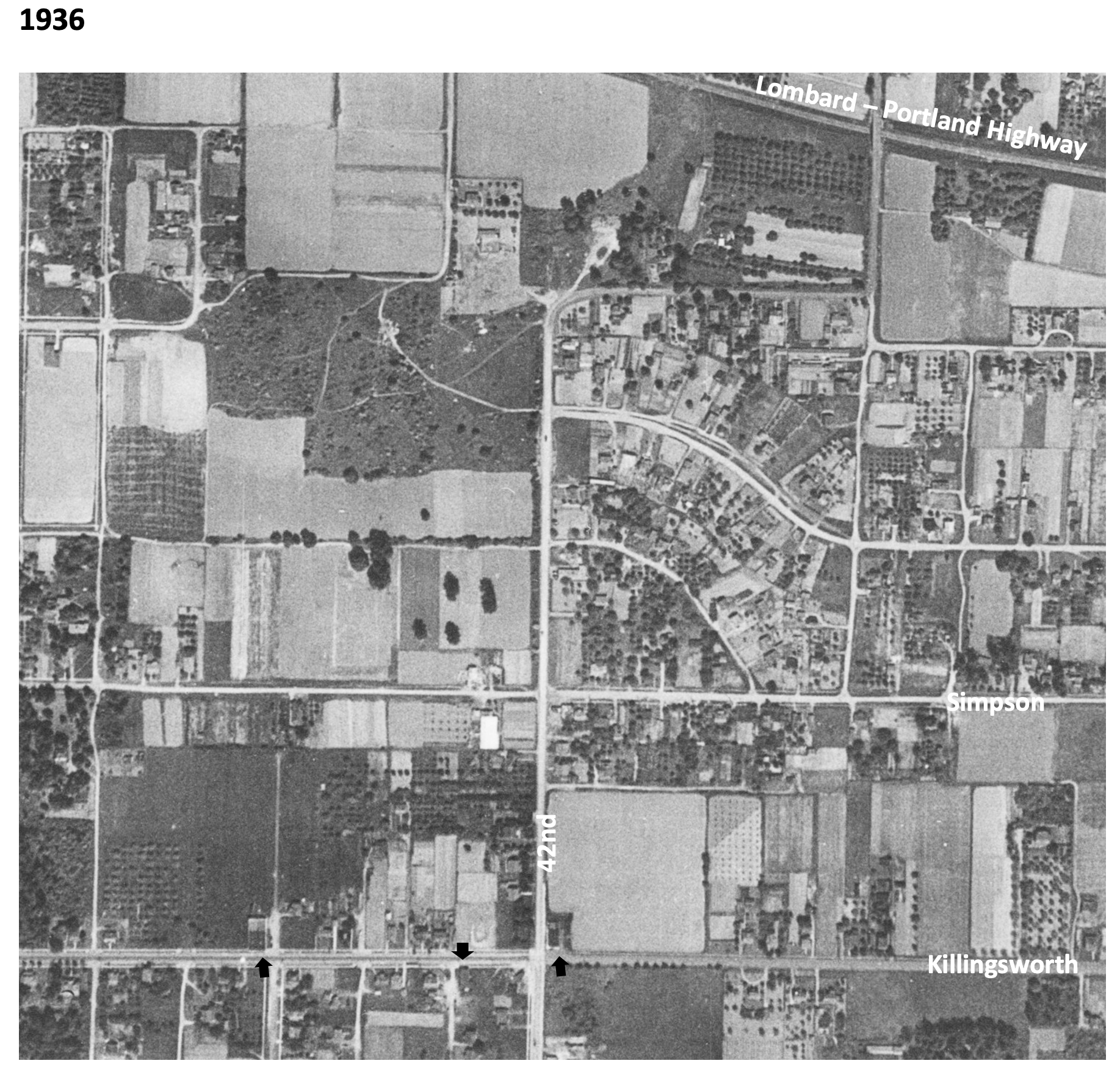
In 1936, the unplowed lowlands of today’s Fernhill Park show up just left of center, and the arc of Simpson Court and NE Ainsworth feed into NE 42nd. No viaduct yet over Portland Highway. The arrows indicate locations of three small mom-and-pop groceries. Note that Simpson goes through east-west, across the middle of today’s Fernhill Park.
In 1939, more houses are showing up, and orchards in the center of the photo are maturing.
In 1948, the 42nd Avenue viaduct is in place (not pictured) connecting NE 42nd to the new Portland Airport. Houses continue to replace open fields. The greenhouses at Knapps Nursery appear west of NE 42nd at Simpson.Orchards near NE 37th and Killingsworth are replaced by homes.
In 1951, a trailer park appears at the NE corner of 42nd and Killingsworth in what were once open fields. Significant new home construction is evident north of Killingsworth and west of 42nd. The flat playing field at the south end of Fernhill Park begins to emerge from the former agricultural fields north of Simpson, and west of 42nd.Construction is underway on the new St. Charles Churchand school.
In 1961, the trailer park is replaced by a large Safeway store and parking lot at the corner of 42nd and Killingsworth, which opened in 1957. A baseball diamond is clearly visible in the new Fernhill Park. Orchards and open agricultural fields are gone.Simpson still goes through west of Killingsworth.South of Simpson in this area, 26 homes, three duplexes, a PGE power substation, and Knapp’s greenhouses and nursery are soon to be demolished or moved–over the strenuous objection of neighbors–to make way for John Adams High School.
In 1971, John Adams High School is in place, replacing a portion of the open areas of Fernhill Park and most of the homes between Killingsworth and Simpson west of 42nd. Simpson no longer goes through west of 42nd. Acres of parking are available west of the Safeway storeat 42nd and Killingsworth.
By 2020, John Adams High School (later known as Whitaker Middle School) was demolished in 2006, but the track remains. Neighborhood street tree canopies are filling out.Safeway is closed and the buildings at the northeast corner of 42nd and Killingsworth are now gone.
Photographs taken 91 years apart remind us about change and constancy at a busy corner in the neighborhood. Check it out:
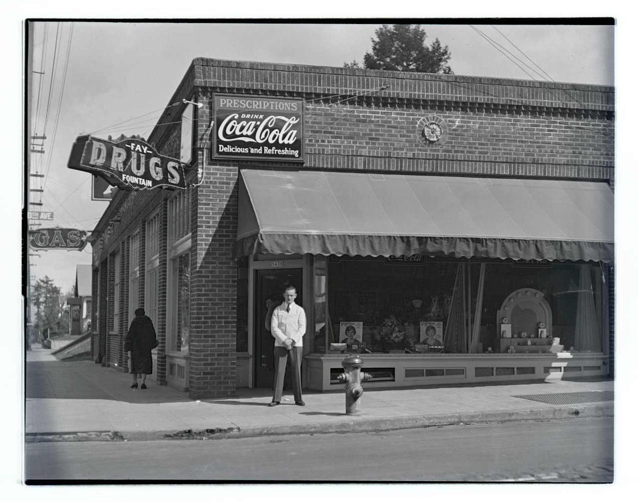
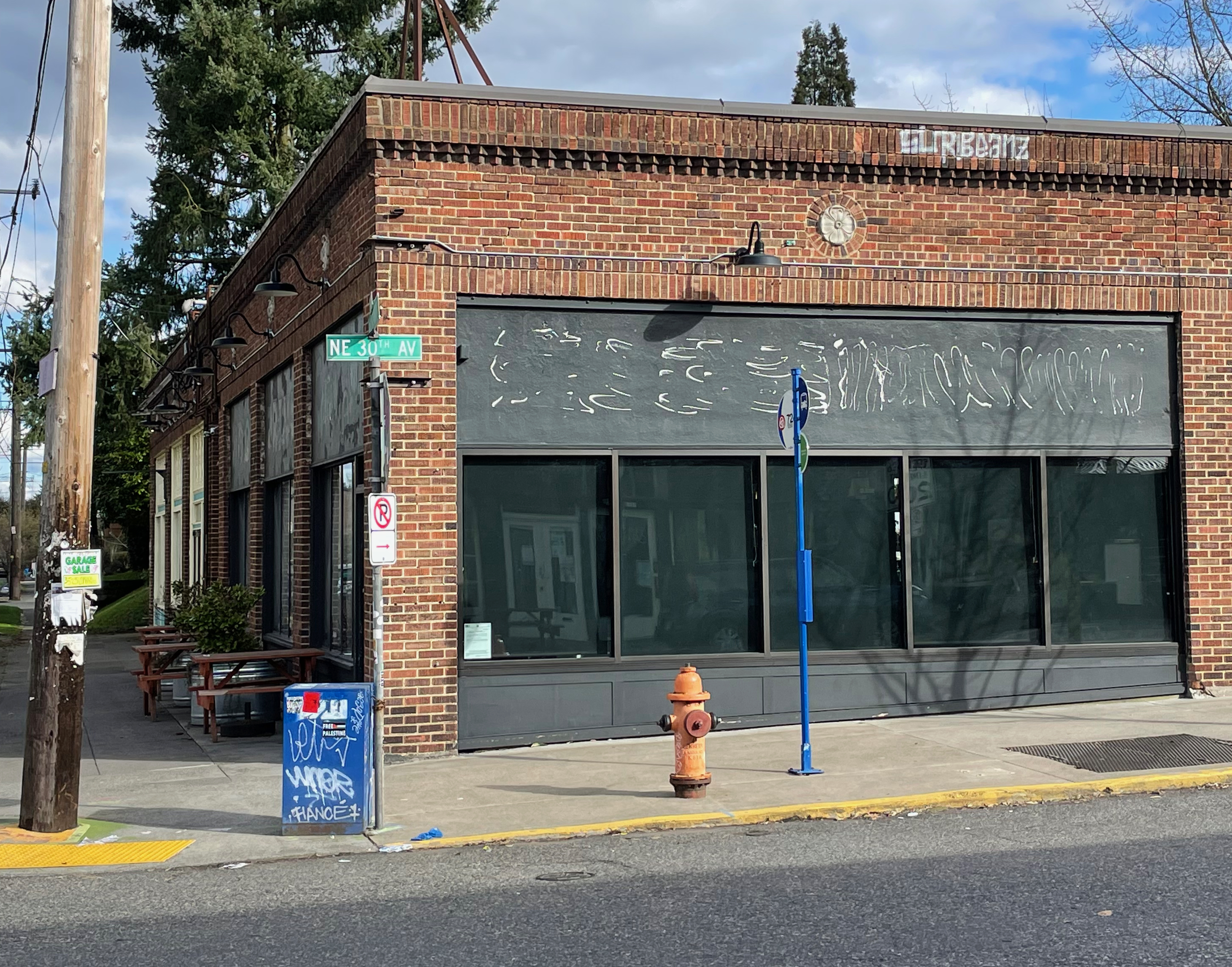
Top: View looking east, Joseph Laurence Fay (1906-1951) poses in front of his business at the southeast corner of NE 30th and Killingsworth in 1933. Photo from the Oregon Journal Negative Collection at the Oregon Historical Society, Lot 1368; Box 372; 372A1209. Bottom: The same view in March 2024, when this storefront was in transition.
Built in 1927, this commercial block of storefronts has housed everything from Fay’s Drugs and Fountain–pictured here in a photo from the Oregon Journal in 1933–to the RCA Service Company, to the Portland Venetian Blind Company. In the 1950s it was home to neighborhood dentist Dr. Tinkle. More recently, it’s been a coffee shop and café, a bar and a game arcade.
This busy corner, known as Foxchase, is well worth exploring: several good restaurants, a great cocktail lounge, a new bakery and more. And the story of Foxchase is pretty fascinating too, be sure to check it out.
We’ve been helping a long-time Northeast Portland family sort through their 100-year-old photo albums to identify some mystery locations and develop context about important family places. We love working with old photos (there’s a whole category here on the blog called Photo Detective dedicated to the topic which we think makes interesting reading and looking).
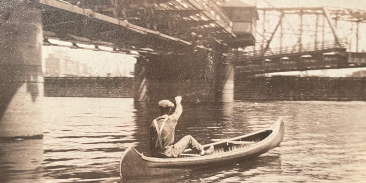
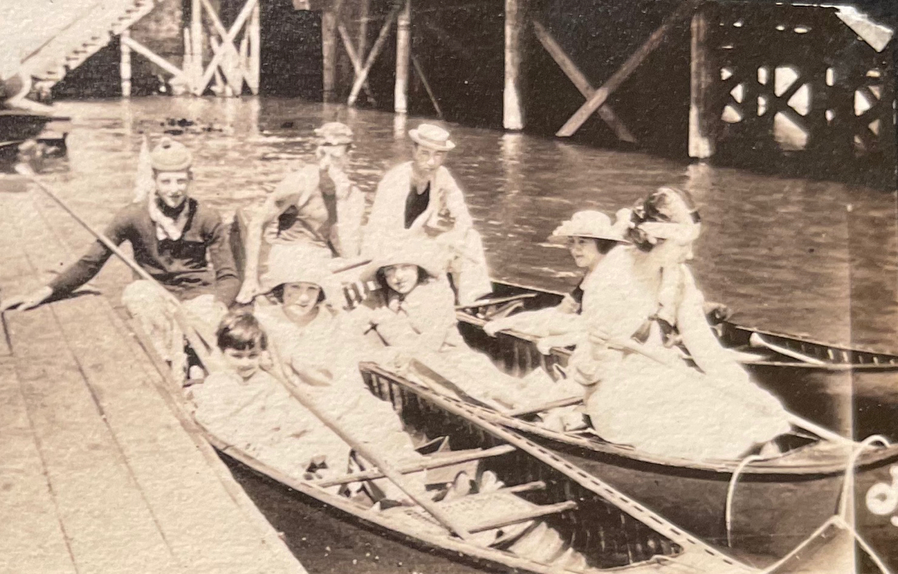
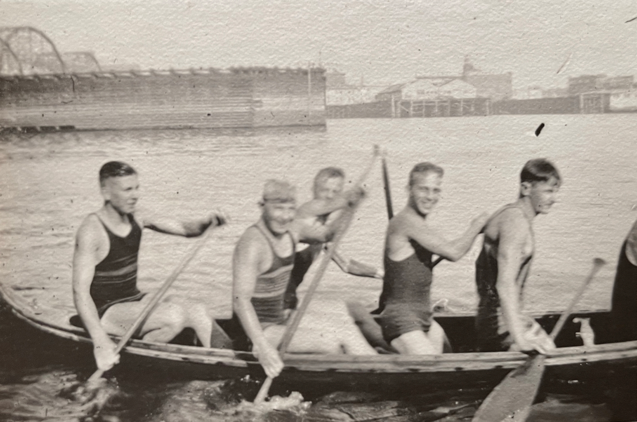
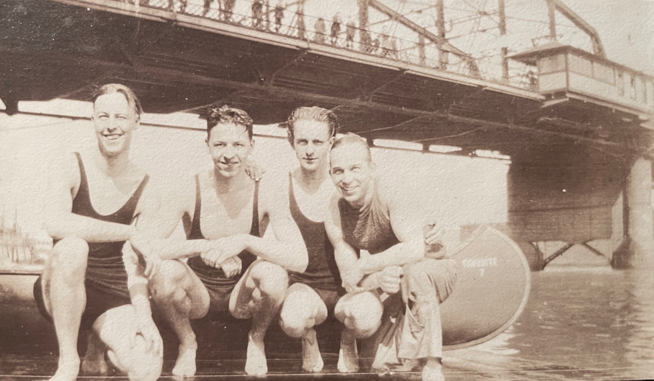
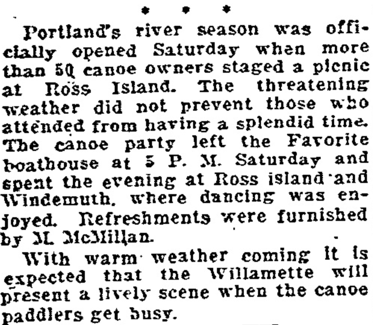
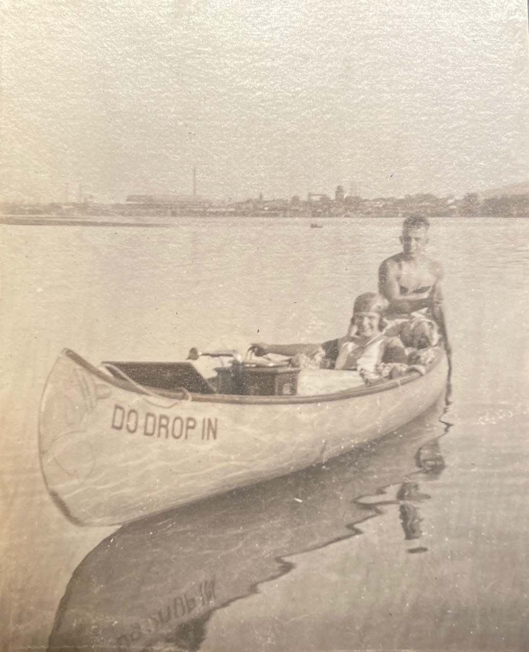
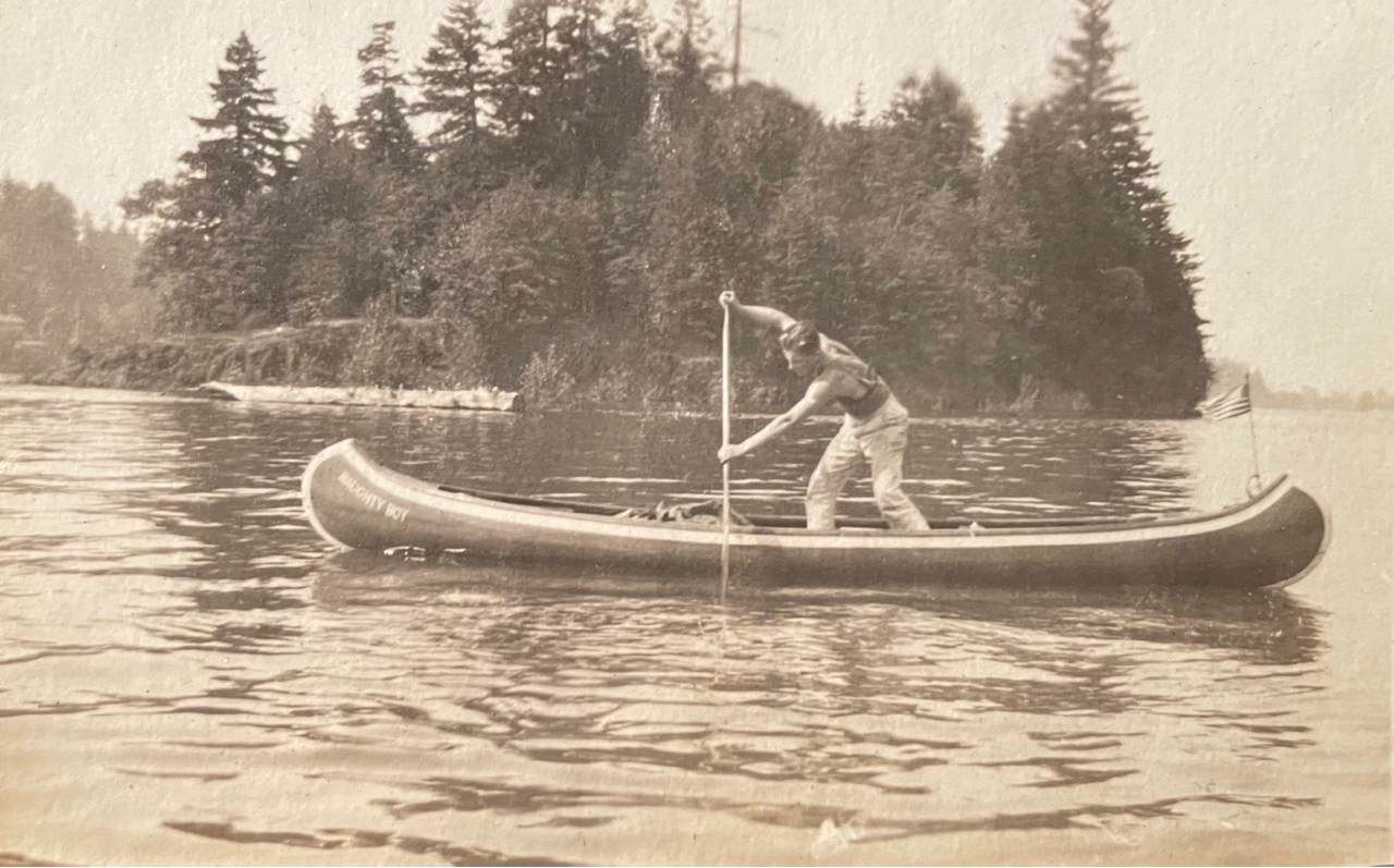
100 years ago, this family loved to play outside and one of their favorite places was the Willamette River between Swan Island and Oak Grove. Like so many young Portlanders of that era, their key to exploring these places was a canoe.
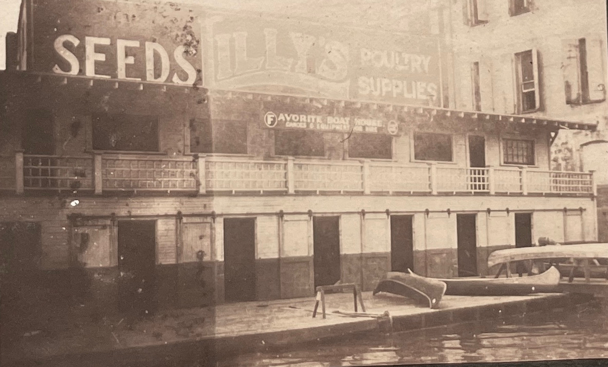
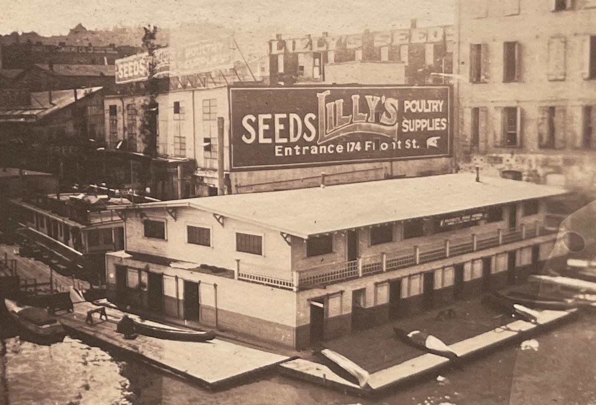
Departing from The Favorite Boathouse under the west end of the old Morrison Bridge, a swing bridge built in 1905 that was replaced in 1958 by the bridge we know today. In the photo above looking to the east, the eastern span of the old bridge is swung open to allow heavy river traffic to pass.
Along with front-porch moments of young families, babies and World War 1 soldiers returning home to Northeast Portland, the albums contain pages and pages of river adventures from the summer of 1919. Since we are frequently in the same waters by kayak and canoe, finding these glimpses struck close to home and got us wondering about the connection between Portlanders and the Willamette 100 years ago. These young people clearly were connected with their river, which looks to have connected them with each other in the special way that rivers do.
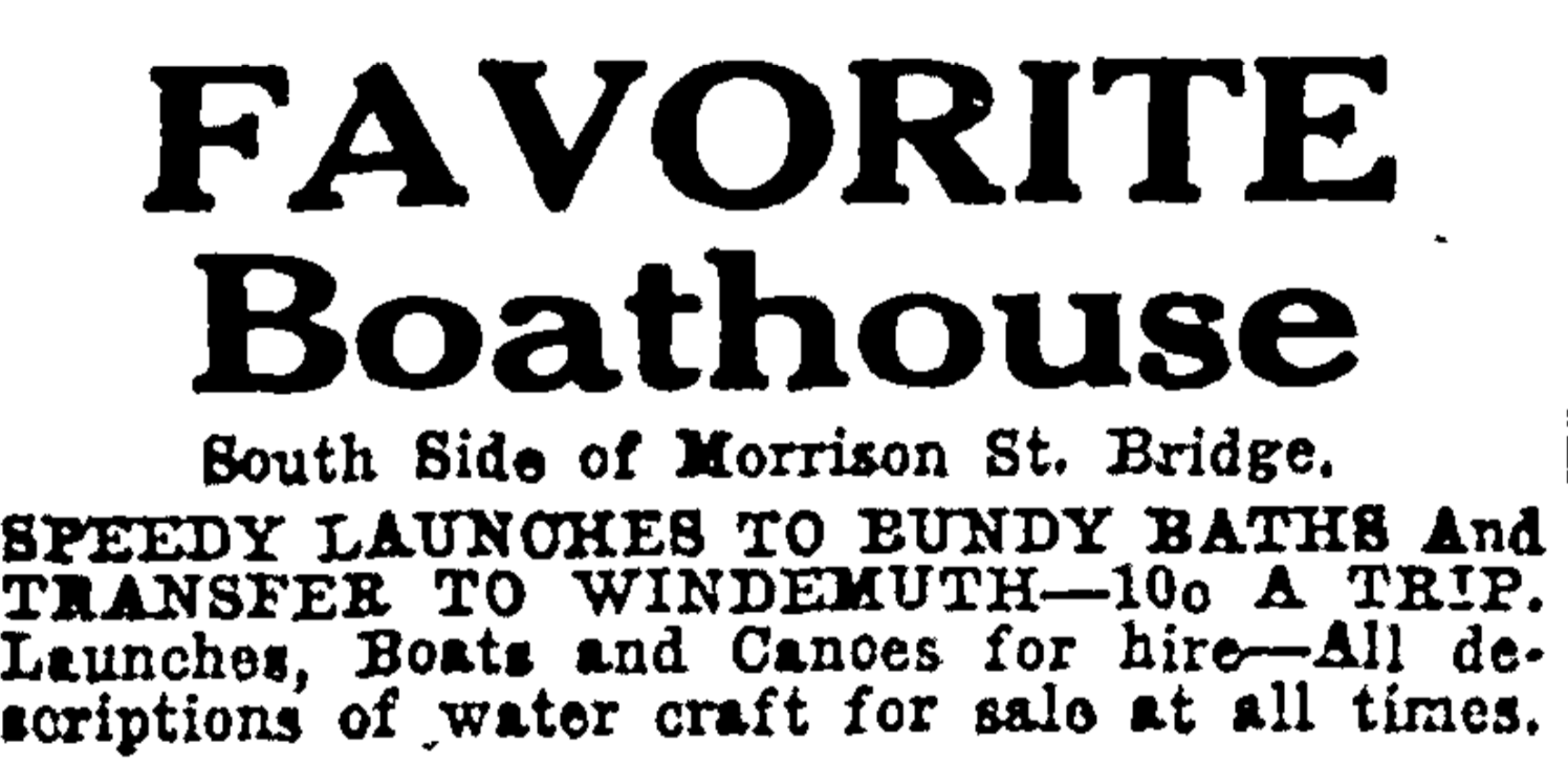
A boathouse on the west bank of the Willamette just south of the Morrison Bridge seemed to be at the heart of many adventures, a place appropriately called “The Favorite Boathouse.”
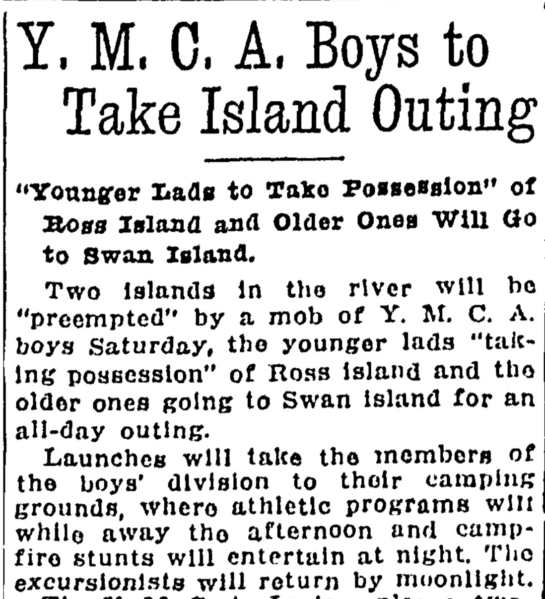
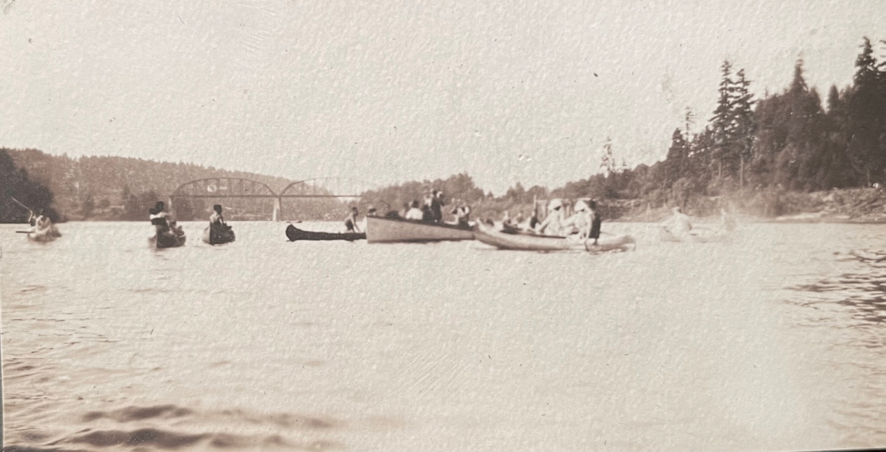
A look through the Oregon Journal and The Oregonian during these years opens a window into just how many young Portlanders took to local waters by canoe. At the time, Ross Island and Swan Island were outposts for recreation (and Swan Island was still very much an island). In 1916, both were destinations for organized outdoor recreation.
From the Oregon Journal, April 20, 1916.
From The Oregonian, April 25, 1921
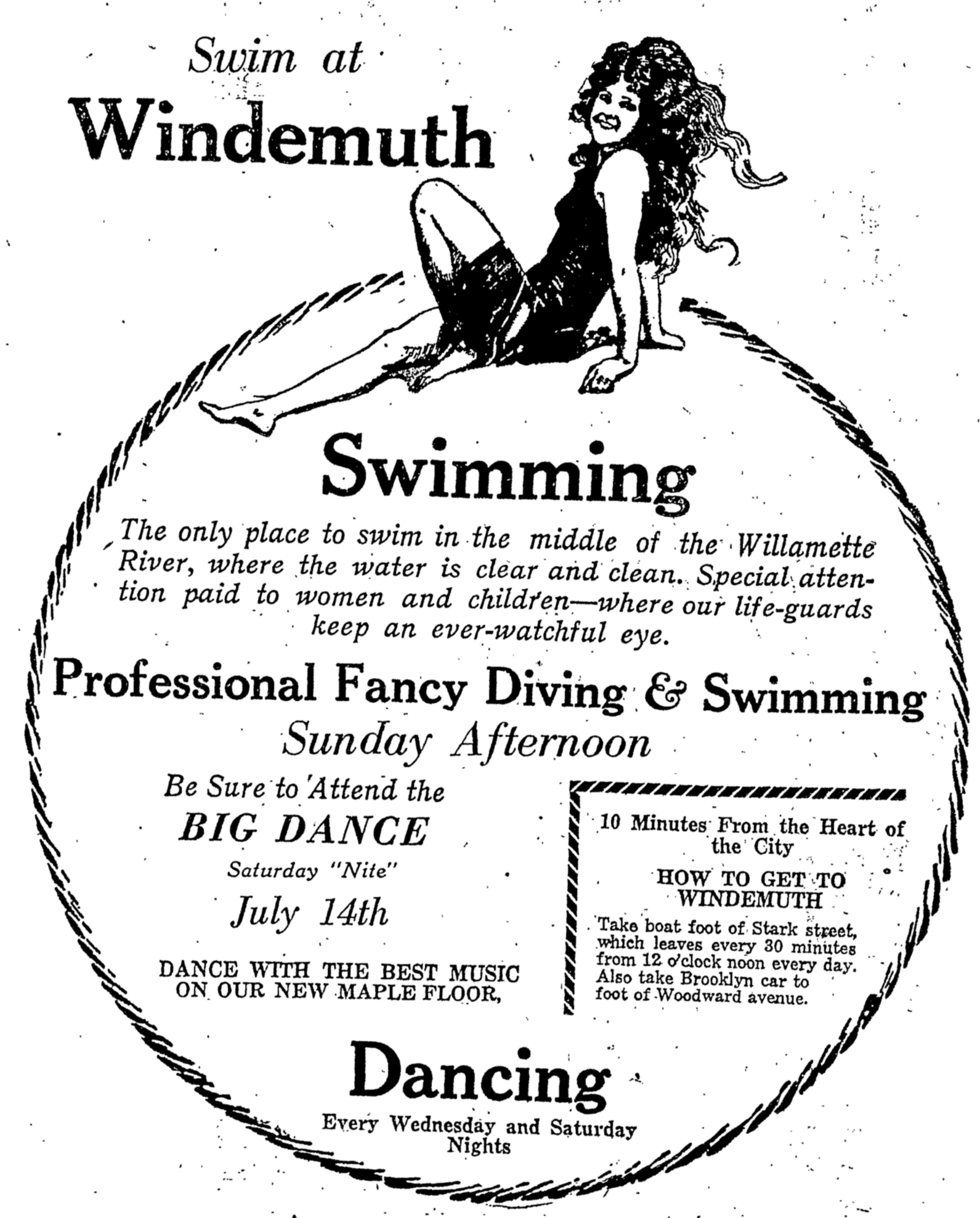
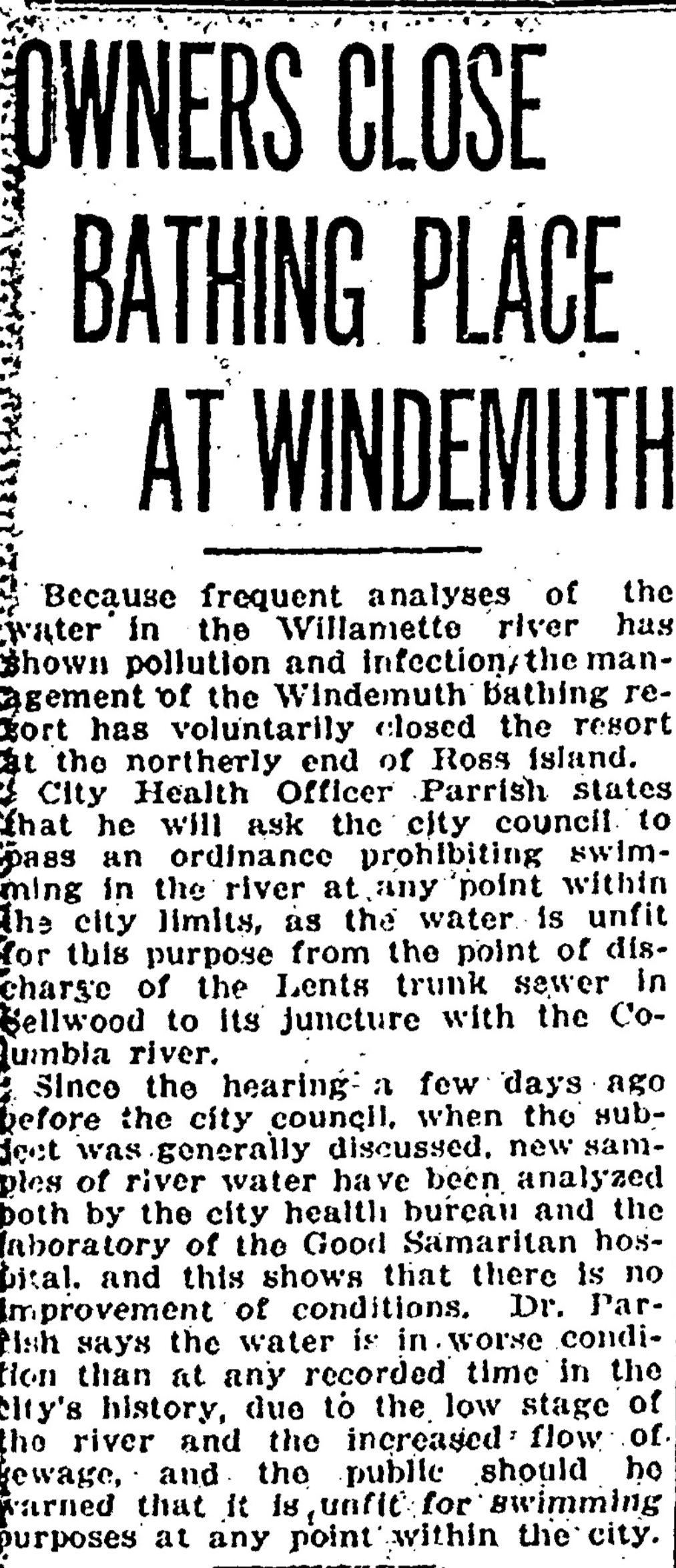
A popular destination for Willamette paddlers in the late 19-teens and early 1920s was Windemuth, a giant floating swimming pool and dance pavilion anchored in the river off the northern tip of Ross Island. By day, Windemuth featured swimming competitions and all manner of water play. By night, hundreds of paddlers arrived to dance on the floating dance floor.
From the Oregon Journal, July 14, 1923
The Favorite and other boathouses rented canoes for couples and groups to paddle upstream to Windemuth for the summer evening dances. If you didn’t want to paddle, you could pay to ride a scheduled “motor launch” from downtown. Or from the eastside, you could take the Brooklyn Streetcar to the foot of Woodward Street and catch a short boat ride across to the floating pavilion.
Unfortunately (and not surprisingly) there were frequent swampings of canoes from the wakes of the many steamships active in Portland harbor, and regular drownings, often at night, coming and going to the islands.
From The Oregonian, May 14, 1923
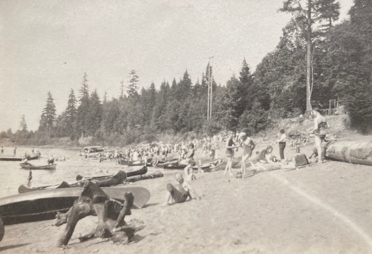
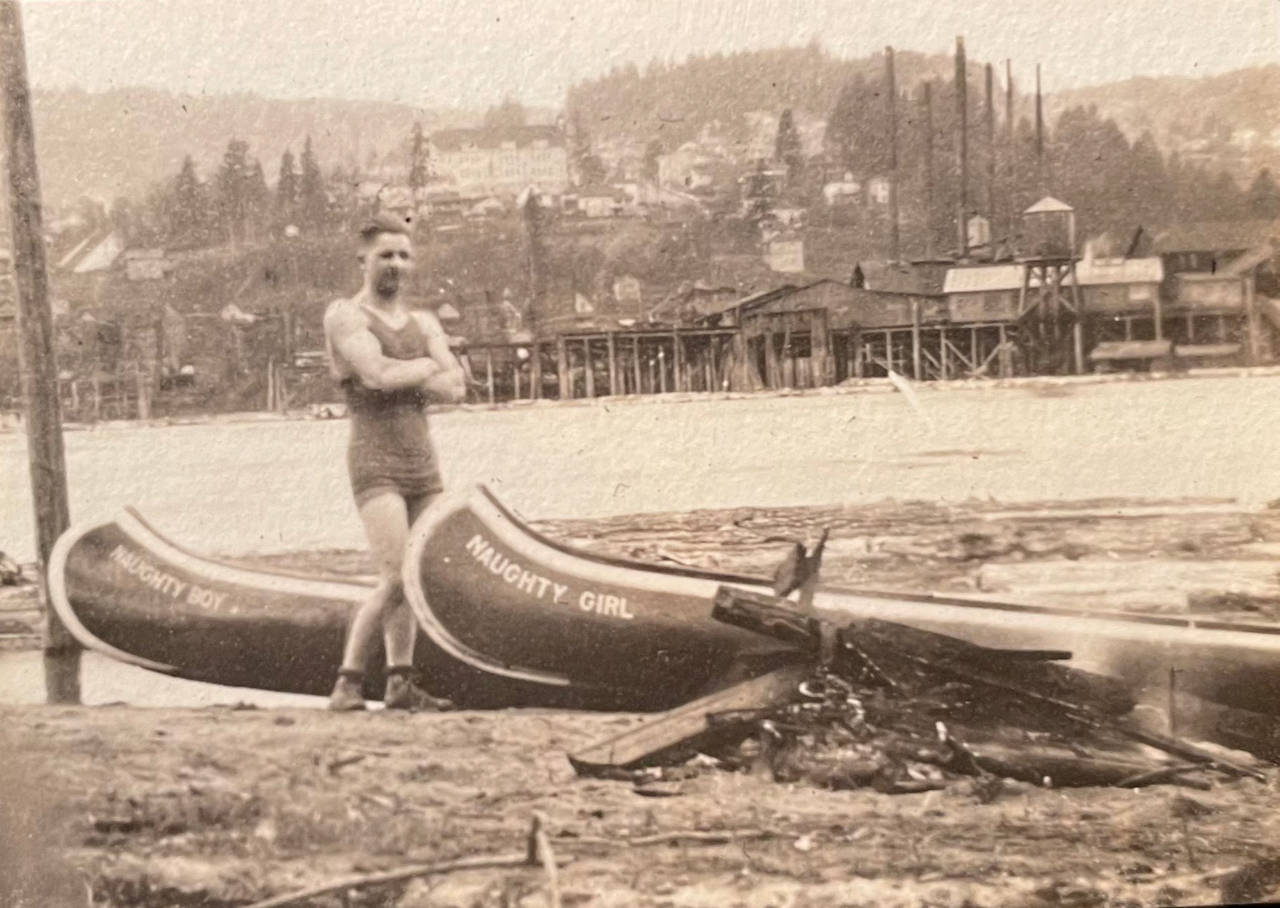
On Swan Island north of downtown, the beach in summer was filled with canoes that brought young Portlanders over the waters to sunbathe, picnic and camp.
Looking toward downtown from near the beach on Swan Island. Note the Victrola record player in the front of the canoe. The Victrola and its records, picnic boxes, bags of clothes and camping gear show up as payload in multiple photos. Summer 1919.
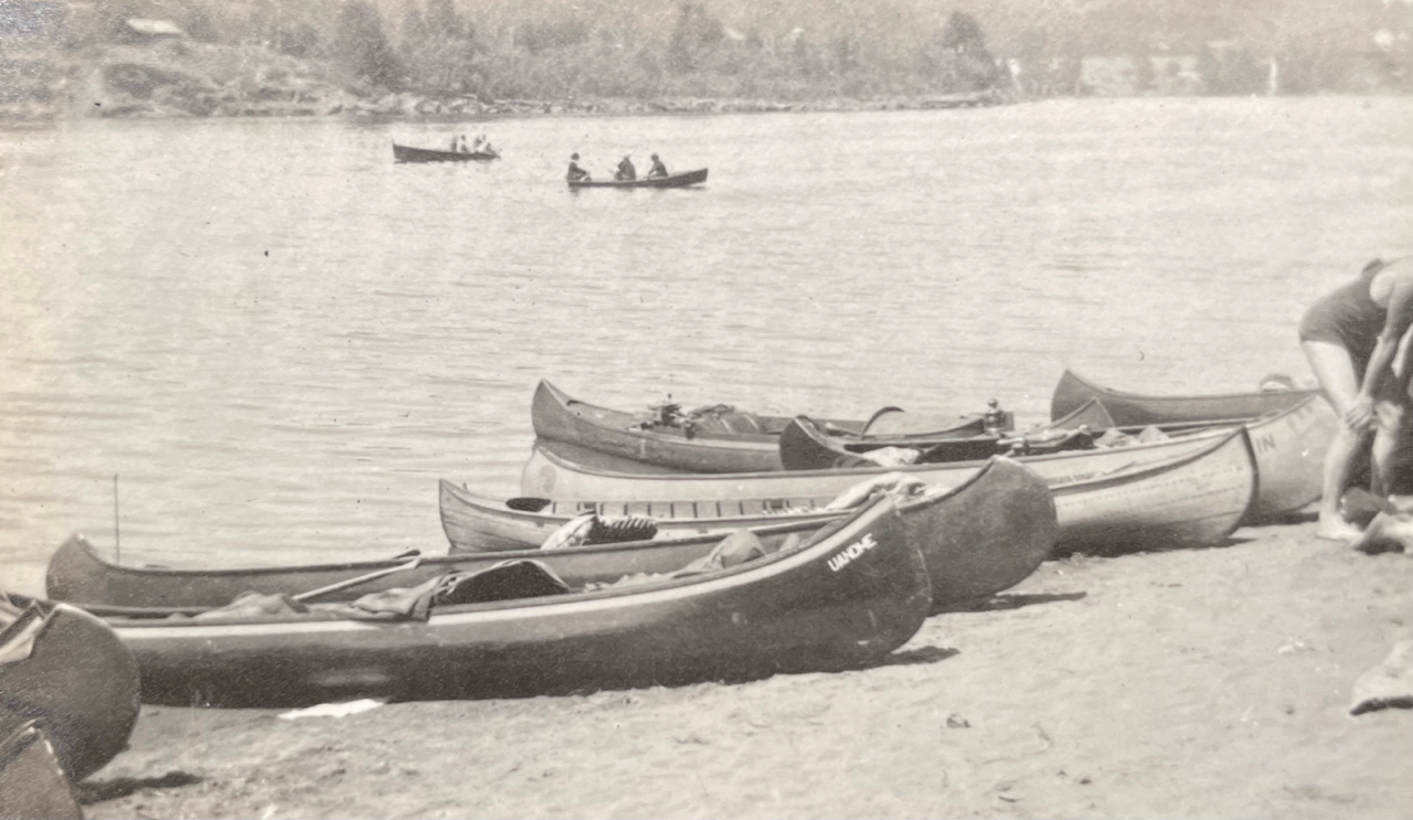
Handed down family stories describe young people swimming among and playing on the many rafts of logs that were tied up along the Willamette banks awaiting use by local sawmills. During these years, log rafts lined both shores from the Sellwood Bridge to St. Johns.
Taken on the western shore of Swan Island looking to Portland’s west side, with two canoes. The sawmill on the far side of the river is the Northern Pacific Lumber Company mill located in the vicinity of today’s Terminal 2 on NW Front Avenue. The very large building in the background is the old St. Vincent Hospital located on Northwest Westover. A log raft is visible anchored just off the near shore behind the canoes. Summer 1919.
Family members enjoyed paddling farther south, around the Milwaukie bend at Elk Rock Island and upstream under the Union Pacific Railroad Bridge at Lake Oswego to the vicinity of today’s River Villa Park, a nice six-mile paddle from the northern tip of Ross Island.
Elk Rock Island, Summer 1919
Looking north toward the Union Pacific Railroad Bridge at Lake Oswego (built in 1910), which is still in use and marks the northern edge of today’s River Villa Park in Oak Grove.
But by the mid 1920s, Portland’s recreational relationship with the river was about to take a major turn, due to health concerns resulting from the reality that the city’s raw sewage went straight into the river.
From the Oregon Journal, July 31, 1924
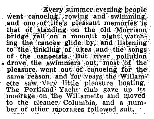
The shutdown relegated moonlight canoe trips to wistful memories a generation later. Below, from the Oregon Journal, May 5, 1946.
The AH blog has been quiet lately because it’s been a very busy winter on many research fronts: specific homes and their builders and people; intersections that are undergoing significant change; the incredible story of three very specific long-lost panels of ornamental glass and the wonder of window restoration and sash making; puzzling questions about everything from street alignments (why is that bend there?), to front porches (what happened to my front porch?). Some interesting things to share in the weeks ahead.
Meanwhile, here are four fresh photos to wake things up a bit, echoing through from our recent series on Sullivan’s Gulch and the arrival of the Banfield Expressway.
You’ve driven past these buildings a million times: part of today’s big U-Store complex on the north side of the Banfield (I-84) at NE 28th, just west of the Hollywood West Fred Meyer.
Here’s a link to the installment from our Sullivan’s Gulch series that references the Doernbecher Furniture Company buildings, which you can still find today if you turn east off of NE 28th at Sullivan Street, just south of the Banfield. Go down that hill, through the tunnel, cross the tracks and take a look. The crossing is in the same place as it appears in this 19-teens photo above, courtesy of the Oregon Historical Society.
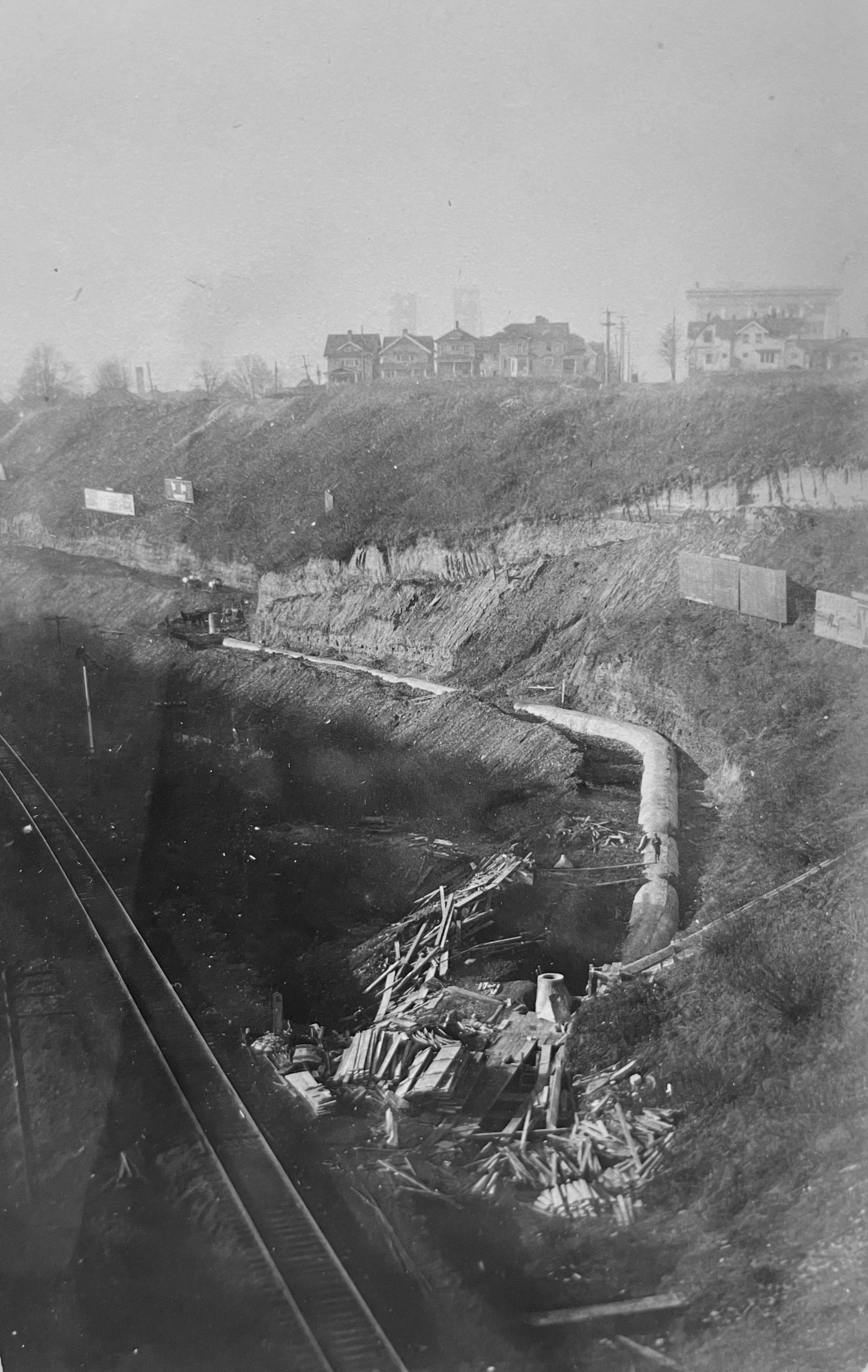
Here’s an even earlier westward view of the Gulch that we’ve come across, taken in the early 1900s just below where the State of Oregon office building is today on Lloyd Boulevard. The photo was taken to document progress on the trunk sewer that was constructed down the gulch (you can see it there in the bottom…the man is walking along the top of it). By triangulating the photo with old Sanborn Fire Insurance maps, our hunch is the houses on the brow of the gulch are at the corner of 7th and Irving. Look carefully, you can see the two towers of the Steel Bridge through the haze to the west.
Trunk sewer in Sullivan’s Gulch, looking west. From OHS photo file on Sullivan’s Gulch
The trunk sewer–and what went in it–was the source of legal wrangling between the various new subdivisions upstream that all wanted to dump their waste into it (but didn’t want to pay for it). The contents were still headed for open water in the Willamette River (not good), but the trunk sewer was an improvement over earlier more primitive ways of sewage disposal.
And our last gem below shows a 1930s view of the clubhouse at the old Lloyd Golf Course. This graceful building, now gone, sat near NE Irving at about 13th (across from Benson High School) and was the gateway to the old golf course.
Here’s more about the Lloyd Golf Course era, and one last photo below from AH reader Steve Goodman showing the building’s later days after the golf course was gone (and when Steve was learning to wash dishes in the dishroom of this very building).
During the Great Depression and the war years of the 1940s, Portlanders had more pressing things to think about than the future of Sullivan’s Gulch. If they thought about the gulch at all, it might have been about their jobs at Doernbecher’s furniture factory, or an escape to Lloyd’s golf course, or the sprawling Hooverville-shantytown at the mouth of the gulch.
Before the speedway: looking west down Sullivan’s Gulch through the Lloyd Golf Course, just west of the NE 21st Avenue viaduct, December 1947. The driving range fence and a corner of Benson High School are visible in upper left. Photo courtesy of Oregon Historical Society, OrHi 91595.
Through those tough years, many families and small businesses struggled just to make ends meet. A quick look at the census shows how many homes on the eastside took in a boarder or two, or had extended family living under the same roof. And if you were a citizen of color or an immigrant, the Portland establishment was more about keeping you down than helping you up.
An influx of workers associated with shipyards and the World War 2 effort brought continued growth particularly on the eastside, and further industrialization along the Willamette and Columbia rivers. Between 1920-1950, our population increased by more than 115,000 people.
Many of those people had cars.
Completion of the Ross Island and Burnside bridges in the mid 1920s allowed direct access to downtown from the eastside. The Ross Island Bridge, completed in 1926, was the first major Willamette crossing that did not include a streetcar route, an important choice and signal of things to come.
By the late 1920s, automobile use had outpaced streetcar ridership and east-west arterials were increasingly clogged with car commuters morning and night. Between 1913 when the Broadway Bridge opened and 1928, the total number of automobile registrations in Oregon increased from 10,165 to 256,527. A powerful force had been unleashed that was going to re-make the landscape.
Another indication of our early car-related growing pains: in 1927 voters approved a street widening levy that literally remade Burnside Street by removing entire portions of buildings and adding street lanes to cope with increased traffic. Similar work took place on Northeast Broadway in the early 1930s.
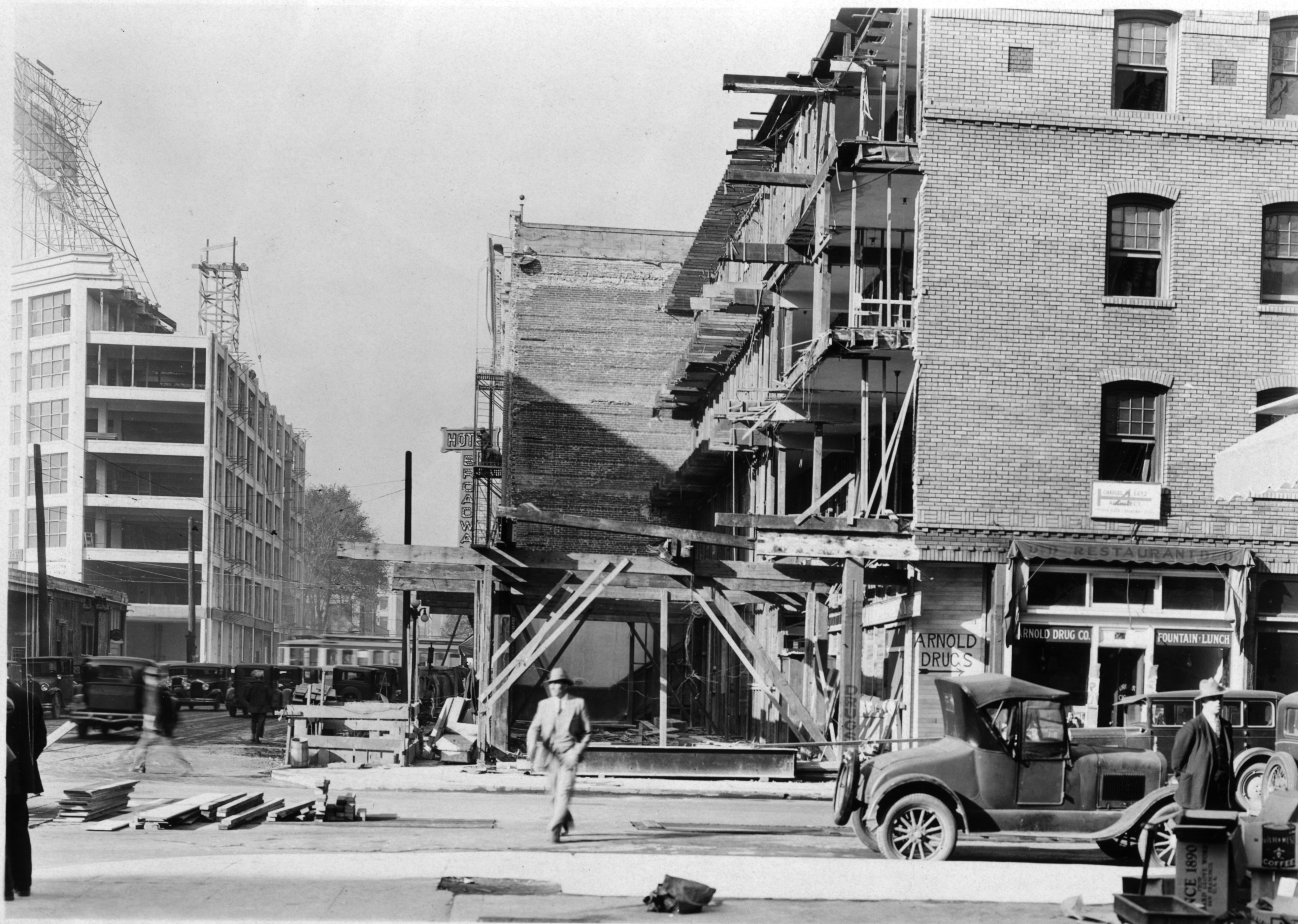
Looking west at NW 6th and Burnside during the widening project. Buildings on both sides of the street were cut back to make way for more lanes and more traffic. This was not a popular move as Portland struggled with growing pains. Photo courtesy City of Portland Archives, image a2001-062-2
Despite these changes—or perhaps because of them—City Council received an increasing number of complaints about traffic on Fremont, Broadway, Burnside, Stark and Hawthorne. The writing was on the wall for a bigger traffic congestion “fix.”
In 1944, City Commissioner William Bowes brought up C.A. McClure’s earlier Planning Commission speedway vision. The State Highway Commission—chaired by T. Harry Banfield—was on board and suggested the city not grant any more building permits along the Sullivan’s Gulch right of way. If the speedway vision was going to come to pass, it was time to stop allowing development along the edges of the gulch. By agreeing, Portland inched closer to endorsing the project.
As the war years ended, the topic rose to the top of Portland civic life and news coverage.
From The Oregonian, February 24, 1946
City Council placed a money measure for the expressway on the May 21, 1948 ballot asking if Portland voters were ready to pass a $2.4 million tax levy for the city’s share of a $10.5 million project to build a gulch expressway that would theoretically ease traffic problems. Interestingly, also on the ballot that day was a city ordinance requiring the leashing of all dogs…council didn’t want to be alone with just its fingerprints on that explosive decision either.
The resulting public dialog and advertising campaign about the expressway levy produced fireworks as people and businesses chose sides:
From The Oregonian, May 20, 1948
From The Oregonian, May 19, 1948
Portland City Club added its voice and recommendation with a report considering the pros and cons of the expressway, including an awareness for Portlanders that construction would require demolition of more than 110 homes along the right-of-way.
The results of the vote were an unequivocal no: Portland was not interested. (Results of the dog leashing ordinance were far less clear: it was defeated by a mere 4 percent margin).
From The Oregonian, May 24, 1948
But the establishment was strong and within a week, the Oregon Transportation Commission went ahead anyway with survey and planning work to prepare for major right-of-way acquisition. Spurned by Portland voters, T. Harry Banfield and the commission decided to look elsewhere to fund the speedway vision.
During the week after the landslide vote, The Oregonian editorial board expressed its surprise about the Highway Commission’s decision to go ahead anyway, but endorsed the new highway as necessary for progress:
From The Oregonian, May 27, 1948
Soon, things began to happen, with tangible progress beginning to show on the eastern end of the project and then proceeding west toward downtown. Portions of neighborhoods were bought and houses moved or demolished:
From the Oregon Journal, August 21, 1949
Later in 1949, the Highway Commission had to revise right-of-way acquisition costs upward from $2.4 million to $4.8 million. In August 1950, T. Harry Banfield died while on a fishing trip in Gold Beach, but the vision was well on its way into implementation. By early 1952, the first construction contract for grading at the far eastern end of the highway in the Fairview area had been let for $400,000. In March of 1955, the Doernbecher factory in the gulch at NE 28th Avenue closed and its furniture-making machinery sold at auction. In January of 1956, seven of the Lloyd Golf Course putting greens were sold to Riverside Golf and Country Club for an undisclosed price.
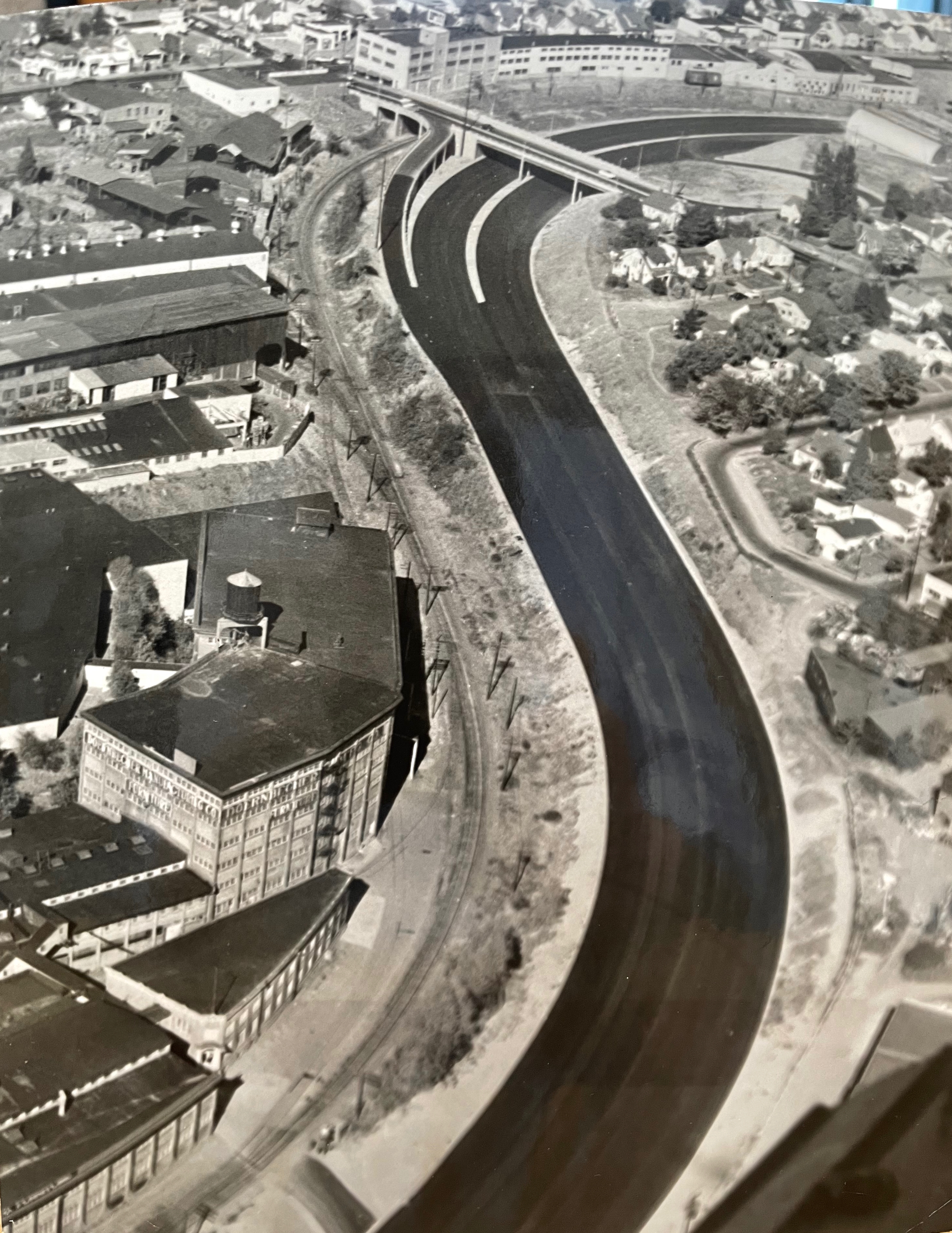
Photos from the 1950s make it clear just how much gulch-widening and dirt moving would be required, particularly in the big bends between NE 21st and NE 37th.
Oregon Journal photo from June 3, 1956, early on in the construction process. Looking up-gulch east from the 21st street viaduct, the rail line visible on the left is running up the bottom of the old gulch and the excavating equipment is widening the south bank with lots more work to do to make it wide enough. Caption on the photo reads “Banfield freeway is being gouged from the earth.” Photo courtesy of Oregon Historical Society.
On October 1, 1955, the highway opened between NE 42nd and Troutdale. Two years later, with funds from the major highway infrastructure bill signed into law by President Eisenhower, the final two miles were completed. By 1960, the Banfield Freeway was fully operational and a century of transformation in the gulch was complete, from natural area to homestead to manufacturing hub, golf course and shantytown.
The deep curves west of the Hollywood neighborhood and the last western stretch to downtown, from the Oregon Journal, September 23, 1957. “Paving of Banfield route progresses. This aerial view looks east from above NE 28th avenue viaduct. At lower left is old Doernbecher furniture manufacturing plant. Upper viaduct is NE 33rd avenue. Only one small stretch above 33rd avenue viaduct is unpaved.” The Hyster plant is also visible in the upper left corner. Courtesy of Oregon Historical Society.
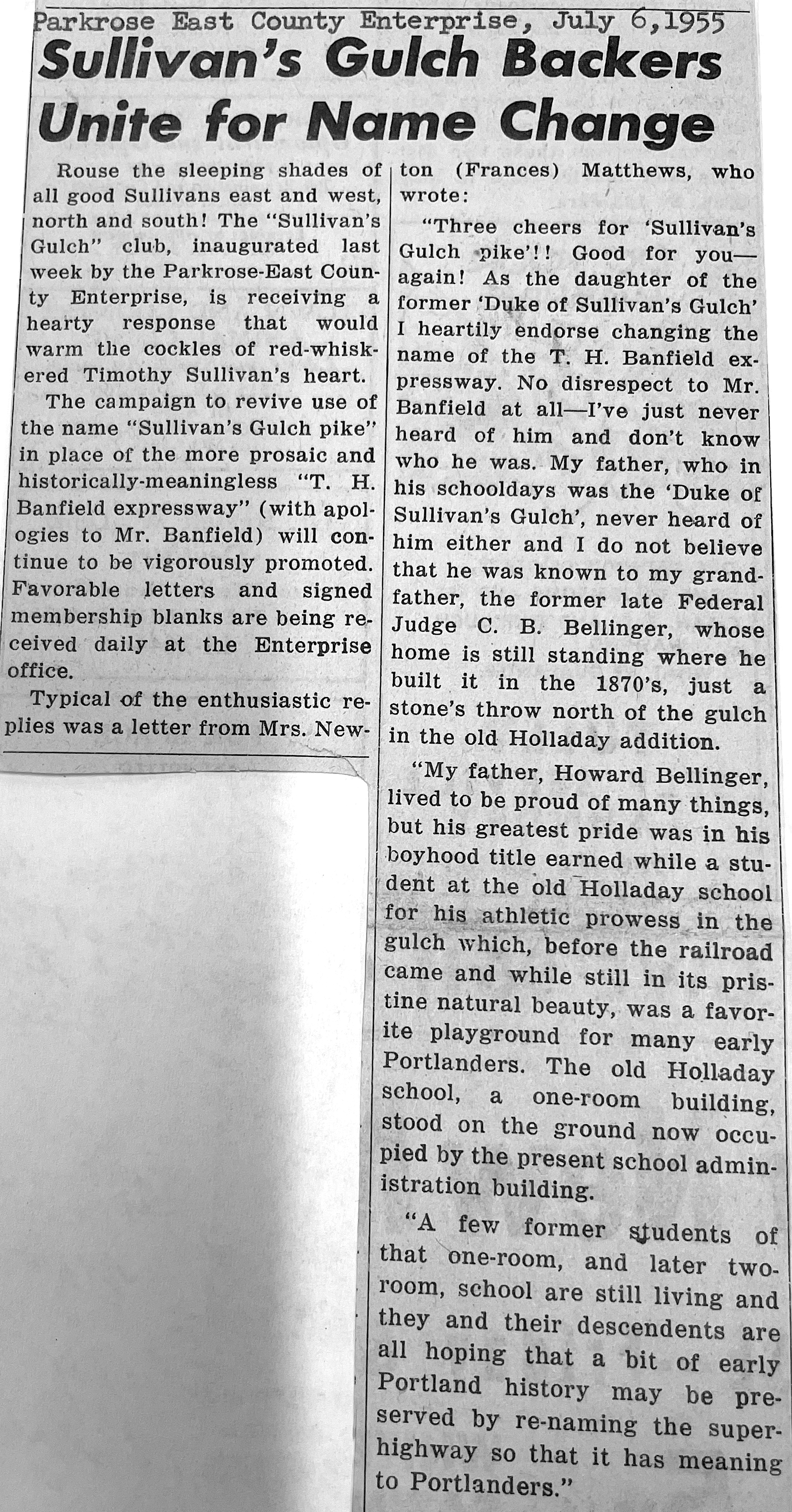
Despite all the changes brought about by the speedway vision, some weren’t quite ready to embrace the gulch’s new identity. A grass-roots campaign that began (and ended) in Parkrose attempted to claim local history, reminding us once again about the importance of places and their names.
Today, it remains the Banfield. But some of us know it’s still Sullivan’s Gulch.
From the Oregon Journal. Banfield Expressway looking west from NE 12th Avenue Viaduct, about 1960. Photo courtesy of Oregon Historical Society.
We’ve come across a digitized collection of photos from 1905—thanks to the Oregon Historical Society (OHS)—that offers a tantalizing glimpse of homes and street scenes on Portland’s eastside, including one we’ve been able to identify and a bunch of others we’re still working on.
The collection which resides at OHS includes 88 individual glass plate negatives taken by an unknown photographer that were left behind in a Northeast Portland boarding house.
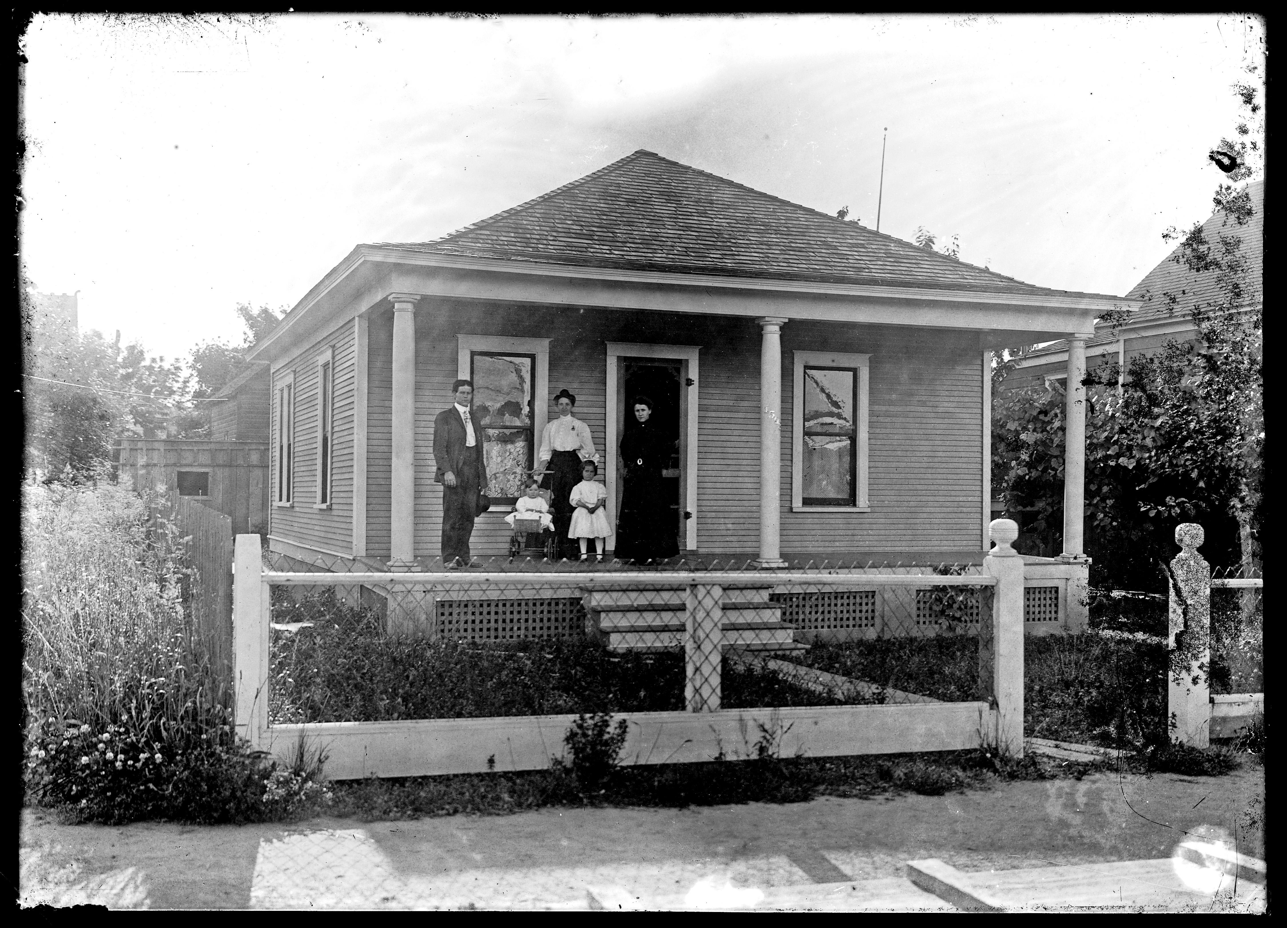
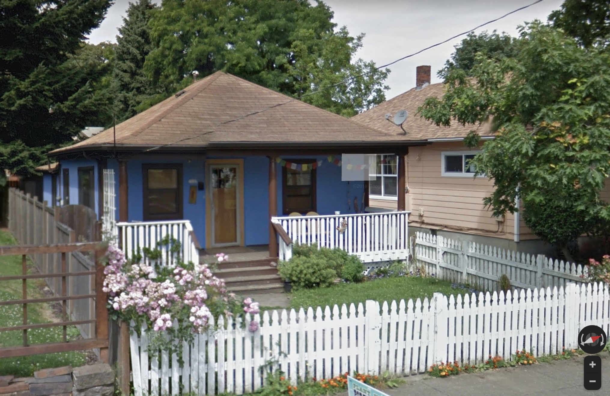
Many of the photos depict the Woodlawn neighborhood. The one we sleuthed out is a tidy one-story hip-roofed bungalow not far from Woodlawn School that looks a lot today like it did back in 1905. See for yourself:
Glass negatives of early Portland residential scenes, Org. Lot 1417, Oregon Historical Society Research Library, image 039. Used courtesy of the Oregon Historical Society.Theoriginal address of the home was 1503 East 11th Avenue North.The same house today in the 7200 block of NE 11th Avenue. Google Streetview image.
This particular photo was not too difficult to identify because the home’s pre-address-change address is visible on the front porch column. With a little detective work we were able to identify this as a home in the 7000 block of NE 11th Avenue.
We’re confident there are other distinguishing details in these photos that will be tantalizing to many of us photo detectives. But even if you just enjoy a little time travel, it’s so interesting to have a close up look at these houses as brand-new buildings, to see the family moments and groups, the dirt streets and background views.
Read more about the collection and take a good look through the images via Ilana Sol’s blog post on the Oregon Historical Society website, and then take a good look through the images. And let us know if you identify any of the places!


