Rest of the Story: The Lost House at 33rd and Fremont

Our recent post about the old gravel pit and landfill at NE 33rd and Fremont produced some interesting mail and conversation that helps complete the picture of the house that once stood at the southwest corner of that intersection.

First, a photo from frequent AH source and long-time neighborhood resident John Hamnett showing the house. John and his father were out in the neighborhood with a camera on the sunny day following the great Columbus Day Storm of Friday, October 12, 1962 documenting damage and downed trees. John remembers they came upon this toppled fence and wall on the south side of the house. The blue and white enclosure surrounded the swimming pool. The Oregon Encyclopedia entry about the storm reports wind speeds were clocked as high as 170 mph.

Looking north at the southwest corner of NE 33rd and Fremont, October 13, 1962. Photo courtesy of John Hamnett.

Next, we re-discovered this 1954 photo looking north up the hill toward Fremont from the corner with Klickitat. When you click into this image, you can see both the mid-century modern house that was eventually removed from the site, and the house behind it, which still stands. Looks like a vacant lot just downslope.

Photo Courtesy of City of Portland Archives, image A2005-001.955. Click to enlarge.

And last, this helpful comment from Judy Wathen, who used to own the house, and remembers it from its heyday of the 1950s.

My husband and I were the ones who bought the house with the swimming pool on the corner of 33rd and Fremont in the ’90’s. Before we bought it we had two different geological engineering firms test the soil and evaluate it’s stability. Both said that it was stable and leveling the house could easily be done. Both were wrong. The cost to stabilize the house was beyond our resources. Fortunately, a grade school classmate, Terry Emmert, offered to buy the house and move it to become the first remolded home on the Street of Dreams. We sold the lot with all the engineering studies to a builder who hopefully did what was required to stabilize the land before he build what is there today.

A little bit more history about the house. I grew up in Laurelhurst in the 50’s-60’s. Our family drove by that house regularly on the way to Riverside Country Club, where we were members. My father told us about the house. My father’s friend, who owned the well known Fox Furniture Co., built the house with the swimming pool  as a wedding gift to his daughter and her husband and that it was built and finished to the highest quality. That certainly was true, except for understanding the engineering of the foundation.

Goodbye (again) Kienow’s

We heard news over the holiday that QFC will soon be closing its Grant Park market, located at NE 33rd and Hancock.

The imminent closure has sparked comments and memories here on AH and elsewhere, not about QFC (sorry about that, QFC), but about Kienow’s Market, which is what that place was for most of its life, from the mid 1930s until 1999 when this Kienow’s closed and the store became a QFC. For the record, we will miss the convenience of being able to slip into QFC for a few quick items on the way home.

Beyond living memory? Here’s the original store that stood at the southwest corner of 33rd and Hancock, pictured in 1939. The store also had a dwelling unit on the south end. This building was demolished in the mid 1940s when the full-block version of the store that most people remember was built. From The Oregonian, May 26, 1939.

You couldn’t grow up in this part of northeast Portland in the mid 20th Century and not have a Kienow’s memory, and AH readers have been sending us theirs, which we wanted to share here. We also wanted to reach back a bit before living memory to understand the earliest history of groceries at that corner.

We’ll do this chronologically, taking us back to 1912 when a small store attached to a home existed at the southwest corner of NE 33rd and Hancock. Building permits suggest that first store + house (you can see its grainy photo above from the late 1930s) was actually an old repurposed school building from 33rd and Tillamook (the first Fernwood School) that was moved to the Hancock corner, where a basement was dug, a chimney built, and a storefront stuck on the front.

At that time, the property was owned by Carl Abendroth and later by his brother Adolph and was known both as Abendroth’s and as Fernwood Grocery, after the school building we know today across the street was built in 1911.

Abendroths tried to sell the shop and property starting in late 1915. Here are two ads that help us imagine what the place was like:

From The Oregon Journal, November 28, 1915

From The Oregonian, January 9, 1916


The store and property was still in the Abendroth family in 1921, but by 1932 it was known as Randall’s and whoever owned the property placed classified ads selling off the “timbered land” adjacent to the shop to the south. Here’s the Sanborn Fire Insurance map of the property from 1924. The store is in the bottom right corner (but there’s a lot to look at here). Click to enlarge:

In this detail from the 1924 Sanborn Fire Insurance map, we can see a relatively small Fernwood School occupying the full block between Tillamook (which used to go through to 32nd) and Hancock. The precursor building to Kienows is there in the bottom right hand corner (see the “S” next to the “D,” that’s shop and dwelling). It’s interesting to see how little of the neighborhood to the north is built, and check out the greenhouse, sheds and old farm house in the fields to the north. Read more about Sanborn maps here.

Aerial photos from 1936 and 1939 show a vacant lot south of the original building that looks like it’s been planted in rows. A garden? Here it is in 1940, still a shop and house at the corner of NE 33rd and Hancock and a path through the vacant lot to the south, not yet the full-block store that became the Kienow’s that everyone remembers.

Detail of aerial photo from 1940. Click to enlarge. Aerial photo courtesy of University of Oregon Map & Aerial Photo Library.


The first mention of the site being owned and operated by Kienow’s is this full page ad in The Oregonian that appeared on May 26, 1939. Click to enlarge and inspect (10 cents for a box of Rice Krispies!):

Kienow’s was on the leading edge of transforming Portland’s grocery market from the more than 700 mom and pop grocery stores to a much smaller number of midsize and big stores. Fred Meyer and Safeway were also blowing up the small grocery world during these years. But it seemed that Kienow’s was just a bit more down home than its two biggest competitors.

Readers of Beverly Cleary’s Beezus, Ramona, Henry and Ribsy children’s books will also recognize Kienow’s as the grocery store seen out the window of the nearby school. Read more about the local geography of Cleary’s imagination.

Aerial photos from 1948 show the old store and house have been demolished and the full-block storefront is in place, setting the stage for most of the Kienow’s memories we’ve been reading in the last week. Here are a few:

From long-time resident John Hamnett: A few things that I remember about the old Kienow’s store was the meat section and the box bin. There were mirrors on the back of the counter where the meat was displayed. There was a button you could press for the butcher. He would slide open a section of the mirrors to talk to the customers. The box bin was next to the check out registers. Rather than paper bags, the groceries were put into boxes from items that were stocked in the store. The registers were the kind with the rows of numbered keys. The clerk rang up each item one by one and punched in the amount that was stamped on each item. I always marveled at how they could hit the correct keys without even looking at them. It was not like the scanner we have now. Kienow’s had a turnstile at the entrance. You had to leave the store by going out through a check stand and a separate door. As I recall, it didn’t last long before they took it out. There was a 5 & 10 cent store on the north end of the grocery store. I think it was called Lou’s, but I may be mistaken. It was a separate store, but it also had an opening into the grocery store. After school, kids would go over there a buy candy. My favorite was a Tootsie Pop for 2 cents or bubble gum for a penny. In later years, the Bohemian Bakery might have been in this space. 

In the early days of the new full-block Kienow’s, there was also a food counter / diner inside, maybe the precursor to what John mentions as Lou’s. In the late 1940s it was known as Smitty’s Fountain Lunch, and in the 1950s it was the Penguin Café (which relocated here after leaving the Sellwood area). All three businesses sponsored bowling teams (a very popular activity at the time) and searches in the newspaper for any of those names–Kienow’s, Smitty’s or Penguin Cafe–will lead you to a bowling score, not an important factoid about the business.

From Steve Goodman: I remember the original Kienow’s building. It had one row of parking in front, a larger parking lot in back. And the Bohemian Bakery counter that was always busy. In front was a mechanical horse, with leather fringes on the saddle, that I usually tried to beg my parents for a dime to ride up and down. A couple of gumball machines that took a penny were inside, as was an old Coke vending machine where you could see the bottles thru the window. I think a dime for a bottle of Coke.

A major fire struck Kienow’s at noon on March 7, 1952, causing $75,000 in damage, destroying stockrooms filled with cans, and bringing an end to the school day for the children at Fernwood School across the street who were let out to watch the spectacle.

What do you remember about Kienow’s?

We wonder what will happen next with that property. Given the growth of condos and apartments at the intersection to the south, we wonder if the entire two blocks that make up the former Kienow’s (QFC) and the long-vacant Jackson’s convenience store will soon transition to housing.

Light Atop Mt. Hood

105 years ago tonight, Portland craned its neck and squinted to the east for a glimpse of a light atop Mt. Hood. Light rain fell in some places. But across Portland’s eastside at 10 o’clock p.m. many eyes were intently looking east.

During the previous week, an adventurous climbing party from the Portland YMCA had been making its way east first by interurban trolley car to Boring (along today’s Springwater Corridor) and then on foot and by automobile to Government Camp. It was no small task 105 years ago to reach the base of Mt. Hood—something we take for granted today—and the climbing party’s progress was noted in front page news coverage in The Oregonian.

The culmination of the group’s two weeks of hiking, camping and climbing, was to be a planned night-time ignition of 50 pounds of red flare powder atop Mt. Hood to signal all in Portland that the party had achieved its objective. The group carried bags of what reporters referred to as “redfire,” which was probably strontium nitrate powder, known to burn bright red: the same material as in modern road flares.

You have to read the build-up to this big event to appreciate the imaginativeness and chutzpah of this group, and the confusion and dueling stories that followed. Let’s start on July 15, before the group left for the mountain, as they were deciding that they would dig bunks atop the summit for a good night’s sleep.

From The Oregonian, July 15, 1913


The Oregon Journal sent reporters out across the eastside to talk to those who were watching. The next day, here’s what they reported, including eyewitness testimony from people who saw the redfire plainly.

From the Oregon Journal, July 22, 1913

But the real story of what happened, finally reported six days later when the group made it back to Portland, is a little more complicated, real and wonderful. Read on:

From The Oregonian, July 26, 1913 (click to enlarge)

With all the build up, neighbors were ready to see what they wanted to see, despite the sleet and the YMCA group’s turning back that night from the summit. Was it that people wanted to be part of something bigger than themselves, to close the distance between what was wild and the city? Or was it just the moon on a misty summer night?

Tonight at exactly 10 o’clock we’ll be watching.

A Radio Documentary You Might Like

Pretty much everything here at AH is about neighborhood history, old houses and connections between past and present, with a focus on Portland, Oregon. But every once in a while we come across a story about history, family, places and connections across time that strikes some universal cords worth sharing. If you’re an AH follower or frequent visitor, these themes are something you care about too.

We’ve come across just such a story close to home that you might want to have a listen to. Radio journalist Emma Decker has produced a piece airing this weekend on Irish radio that brings these topics right to the top. It’s a 38-minute gem exploring the power of family, choice and a commitment to making the world a better place. And it celebrates mothers, sisters and strong Irish women.

We’re a bit biased about this (yes, it’s that Emma Decker), but when you come across something so honest and moving, you want to just sit down, listen and appreciate.

Listen to the documentary “Sisters” here on RTE’s Documentary on One page.

Portland’s Horse Tethering Rings

You’ve probably seen those old iron rings tethering toy horses to curbs across Portland’s older neighborhoods, a kind of whimsical tip of the hat to our pre-automobile past. But that old hardware rusting on the curb in front of your house is more than just a quaint antiquity: it had an important job to do back in the day.

Many eastside neighborhoods like ours were conceived and built when horses and wagons ruled the streets. In the early 1900s, as Portland was expanding and our neighborhoods were the newly minted suburbs, cars were an unproven, mostly unavailable commodity. In 1905 there were only 218 cars registered in the entire state of Oregon. People got around on foot, horseback and by horse and wagon, but mostly our predecessors here in eastside neighborhoods got around by streetcar. And mostly, neighbors did not keep a horse and wagon at home. So, what’s with all the hitching rings embedded in our curbs?

Every commodity and supply that came to your house in those days was delivered by horse and wagon: firewood, coal, ice, groceries, dry goods, laundry, building materials, parcel post packages. A page of classified ads in The Oregonian from 1900-1910 looks like the land of opportunity for horse-wagon delivery teams and people with strong backs. If you had a horse and wagon, you had a job.

In 1907 Portland City Council passed an ordinance requiring that new curbs in front of houses have “ring bolts” installed every 25 feet so that delivery vehicles could be securely tied down to protect pedestrians and other wagons using the street.

From Ordinances of the City of Portland, 1910

Horse tethering rings weren’t quaint. They were the law.

Many delivery drivers also carried a heavy weight attached to a strap they would place out on the ground—kind of like an anchor—to prevent the horse and wagon from moving around when the deliveryman hopped out and ran up the steps.

Horse tethering weight. These typically weighed 25 pounds and were attached to a wagon by a leather strap. The driver placed these out on the ground when away from the wagon.

By the late 1920s, the automobile (and delivery truck) had almost completely replaced the horse and wagon. Interestingly, streetcar ridership also began to drop off in the late 1920s as more people bought cars and drove where they wanted to go—unleashing a raft of other problems—leading to the demise of Portland’s streetcar system by the late 1940s. But we digress.

When tethering rings became obsolete, the cities of Vancouver and The Dalles passed ordinances requiring their removal due to safety concerns. Here in Portland, one visitor’s misstep resulted in a similar proposed ordinance to do the same. This was actually a front page news story on August 16, 1938:


From The Oregonian, August 16, 1938

Editorial response to the proposed ordinance was immediate, sarcastic, nostalgic. The next day, this unsigned piece appeared on the editorial page, bearing the distinctive style and cadence of editor Ben Hur Lampman, columnist and editorial writer, and eventually Oregon’s poet laureate.


From The Oregonian, August 17, 1938


City Council declined to take action in 1938, but the topic re-emerged in 1947 on the editorial page rising from what appears to have been a chit-chat between Ben Hur Lampman and his grandson. Kind of wistful, we’d say…evidently a topic close to his heart.


From The Oregonian, April 9, 1949


Over the years, the city’s Public Works Department adopted an unofficial policy of removing tethering rings. Some were saved, but many were dumped. But in 1978, when the city went to work on a curb in Ladd’s Addition, one unhappy homeowner picked up the phone and called the newspaper. His complaint, and his desire to remember the past, caught the attention of City Commissioner Connie McCready (who went on to become Portland mayor). The ensuing dust-up put horse tethering rings back on the front page of The Oregonian. Who would have thought?


From The Oregonian, January 7, 1978. Click to enlarge.


In recent years, the rings have re-entered the public consciousness in the form of the Portland Horse Project, dozens of photos and entries about the tiny horses tethered to curbs all across town (just Google “Portland Horse Rings”), and hundreds of acts of creativity and imagination by horse and history fans across the city.

There’s some magic about all of this: the horse rings are here with us in this moment but represent and call to mind a totally different world and time. They ask us to step out of ourselves for a moment to put time and place into perspective, to contemplate both change and steadiness, to acknowledge that what we know about the world today is not necessarily all there is to know. Our old houses do that too.

We love the line from Lampman’s 1938 editorial: “Something there is about the past, there always is, that causes us to put the present to the question.”


Fernhill Park: From wild thicket to popular neighborhood park

It’s often the small and even random things in the past—stuff we don’t pay much attention to or think about now—that make a big difference in outcomes that shape the future.

How Northeast Portland’s Fernhill Park has turned out today is kind of like that: Peel back the layers of history and you can see why things are the way they are today. That’s kind of our broken-record message here at AH, but it’s true.

The hills and gullies that make Fernhill Park distinctive today made it less desirable for crops in the early 1900s.

One of the most prominent features of the park today, located across rolling hills near NE 41st and Holman in Northeast Portland, is responsible for it being a park at all, and probably not for the reason you think. The hills and gullies on the park’s north side, a great place to run the dog in the spring and summer or to sled in the winter, distinguish this place from other nearby city parks.

But back in the day, when much of this area was farmland, this up-and-down topography was a thicket of trees and brush and not very good for growing crops. A close examination of aerial photos from the 1920s, 1930s and 1940s show agricultural fields on all sides right up to the edges where the ground falls off into the ravines of today’s park area. So—the reasoning went—if the city really wants to buy that property from us farmers, go right ahead, we can’t grow anything there anyway.

And that’s just what happened.

After voters approved a property tax levy in 1938 to create more parks and playgrounds for a growing Portland, the city set out on a 10-year process of buying those hills and gullies, starting out in 1940 with a 10-acre parcel owned by the Jackson family right in the middle of it all.

During those years, several dirt roads criss-crossed the north side of the park, one even ran right up the bottom of the gully at the heart of today’s off-leash area in the northeast side of the park, pausing at a wide spot that served as a dump and debris field where car bodies and all manner of junk were strewn.

This detail of an aerial photo from 1940 shows the area of today’s Fernhill Park in the middle surrounded by farm fields on all sides. NE 42nd Avenue is the north-south street on the far right and doesn’t yet go through to Columbia Boulevard (it bends around the corner to the right where Holman is today). The north-south street on the left (that also doesn’t go through) is NE 37th Avenue. The east-west dirt road at the top of the park became today’s Holman Street. Paths, a road and a dump area are visible in the top center of the brush patch. Mike Brink’s grandparents’ home is in the upper right corner with the rows of trees and barn to the south. Photo courtesy of the University of Oregon Map and Aerial Photography Library.

It wasn’t an official dump, but more like a secluded out-of-the-way place where folks from the surrounding area knew they could get away with off-loading a truckful of junk if they needed to. So they did. In the late 1930s and early 1940s, when the NE 42nd Avenue connection to Columbia Boulevard was built, some of the dirt fill needed to make the grade change for the overpass was dug out from and supplied by the gully on the east side of the park along today’s NE 41st Avenue.

Prior to 1940, when NE 42nd didn’t go through to Columbia Boulevard, you could stand near the northeast corner of what is today’s park and see the Kennedy School across the fields and orchards stretching west to NE 33rd Avenue, with more open fields south to Killingsworth and north to the banks of the Columbia Slough. Then during the building boom of the 1940s and 50s, subdivisions marched east transforming the fields into neighborhoods.

Just 10 years later in 1950 the neighborhood was filling in. NE 42nd now goes through to Columbia Boulevard (look for the Tourist Cabins and the Spur Tavern…they’re there). NE 41st has been built and house construction is underway.  And Mike Brink’s grandparents have planted an orchard with orderly rows of filberts south of the house and bing cherries north of the house. Photo courtesy City of Portland Archives.

Often referred to as “truck farms” because the produce was trucked to market (and some of it was sold out of the back of trucks at busy intersections and small markets around town), these surrounding fields produced fruit and vegetables for Portland households. One farm near the corner of what is today’s NE 41st and Holman was owned and run by a Japanese immigrant family, as were others in the area. During WWII, Japanese farming families across the Pacific Northwest were removed from their land and placed in internment camps in southeast Oregon and central California.

We know from our recent visits with Mike Brink—who grew up in the 1940s and 50s in the tourist cabins at NE 42nd and Holman now about to be demolished—that the fields and orchards stretching out in all directions were filled with filberts, apricots, bing cherries, raspberries, strawberries and other crops. Mike remembers walking through them and through the heavily wooded thicket that is today’s Fernhill Park on his way to and from St. Andrew’s School at NE 9th and Alberta. He’d leave the cabins in the morning, pass by his grandparents farmhouse that stood near today’s intersection of NE 41st and Highland, then take the path through the woods and fields over to Ainsworth Street where he’d walk to the corner of NE 30th and Ainsworth, which was the end of the line for the Alberta Streetcar (you should check out this link because it shows the streetcar waiting where Mike used to catch it at NE 30th and Ainsworth). Hopping on a mostly empty streetcar, he’d ride south on 30th and then west on Alberta to school, reversing the process in the afternoon, maybe stopping at a neighbor’s house for hot chocolate on the way home. Quite a solo daily adventure for an elementary school kid, but times were different.

Mike doesn’t remember it being talked about in his house during those years, but gradually, the city was buying up parcels of the woods when bond money was available and when the locals were willing to sell. A couple more parcels in 1942 and 1943. Six in 1949.

As the park took shape through the late 1940s and early 1950s, some locals referred to it as Ainsworth Park, a name that appears frequently in real estate advertising of that era. By the early 1950s, most of the open land Mike remembers to the north of the park had been converted to subdivision (the Vanlaeken and Leitritz additions for readers keeping track of plat names). NE Highland Street was put through the middle of his family’s farm and his grandparents moved to a new house in the neighborhood as the working farm landscape they once knew was transformed into suburbia. By June of 1951 when most of the park buying was done, the city had invested $60,479 and had acquired 25.95 acres.

In this detail of a 1956 aerial photo, the family farm is gone replaced by the cul de sac that is today’s Highland Street and homes are under construction; all of the lots are built up between NE 41st and 42nd in the middle of the photo; a baseball diamond has arrived in the middle of it all; the paths, road and dump are gone. Once again, the Tourist Cabins and the Spur Tavern stand out clearly just right of center toward the top. Photo courtesy of the University of Oregon Map and Aerial Photography Library.


Contemporary view from a hill on the north side of the park, looking off into the Vanlaeken and Leitritz additions. Mike’s grandparents’ farm was off to the right.

On July 14, 1954, City Council passed an ordinance officially naming the area Fernhill Park, a name that was not in local usage prior, but that probably takes its meaning from the hills on the north side of the park.

Construction of Adams High School just southeast of Fernhill Park in the mid-1960s caused quite a stir and protest from the neighborhood. More than 150 angry neighbors turned out at a Portland School Board meeting on September 4, 1964 to share their disbelief that the School Board would demolish 26 homes, three duplexes, a local greenhouse/nursery known as Knapps and a PGE substation to make room for the school. The emotion and sense of loss in the letters and petitions submitted to the school board make for tough reading. Despite this strenuous protest, demolition of the homes and businesses went ahead, construction followed, and John Adams High School opened in September 1969.

From The Oregon Journal, September 3, 1964. The homes and businesses inside the dotted line were demolished to make room for Adams High School.

A dozen years later, when high school enrollment dropped in the early 1980s, the building was repurposed as a middle school and operated for another 18 years before being closed in 2000 due to health concerns about mold. The building sat empty and was frequently vandalized until being torn down in 2006 leaving the large open space south of the track. Newcomers to the area today might not even know that vacant piece of ground south of the track was once a school, and before that a neighborhood, and before that farm fields, and before that an Oregon Trail-era homestead.

No history of the area would be complete without taking it back to the earliest record, when this property was homesteaded under the 1850 Donation Land Claim Act, which Congress passed to encourage settlement of the Oregon country. Isaac and Mary Rennison came across the Oregon Trail in 1852 and settled on and farmed the property, filing their Donation Land Claim in 1855 that encompasses the area bounded today by NE 33rd and NE 60th, Holman and Killingsworth.

Before all this recorded history, let’s not forget that these lands on the south shore of the Columbia River and the Columbia Slough were frequented by the Native Americans who called this area home for more than 500 generations.

Interesting, isn’t it, how the places we know and care about today as our local parks came to us partly because of unpredictable events or circumstances: Alberta Park was a brush patch owned by a Chinese immigrant who didn’t want to sell, or to control the brush and trees while the neighborhood developed around it, so the city condemned the property out from underneath him and turned it into a park. Wilshire Park was tied up in a complex probate process inadvertently delaying development until the city took out a bank loan to buy the property on the eve of its being turned into a subdivision. And much of Fernhill Park was property no one really wanted anyway because it wasn’t good cropland. Today, we take these places for granted as fixtures of neighborhood life.

With these lessons of history in mind, what should we be thinking about and taking action on today that would change some future outcome about how our neighborhood feels and operates in the future? Demolition and densification? Traffic? Hmm. More on that next week.

Old Vernon – Forgotten Neighborhood Ghost

The old Vernon School, located south of Alberta between Going and Wygant, was the center of community life for two decades. Evidence of its presence has faded to invisible today.

Everything about the old Vernon School (1907-1932) has made us want to know more:

It’s gone now, slipped below the surface of living memory leaving few traces, so we’re going to have to reconstruct a sense of it through research, experience and a little imagination, which is what we love to do.

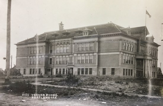
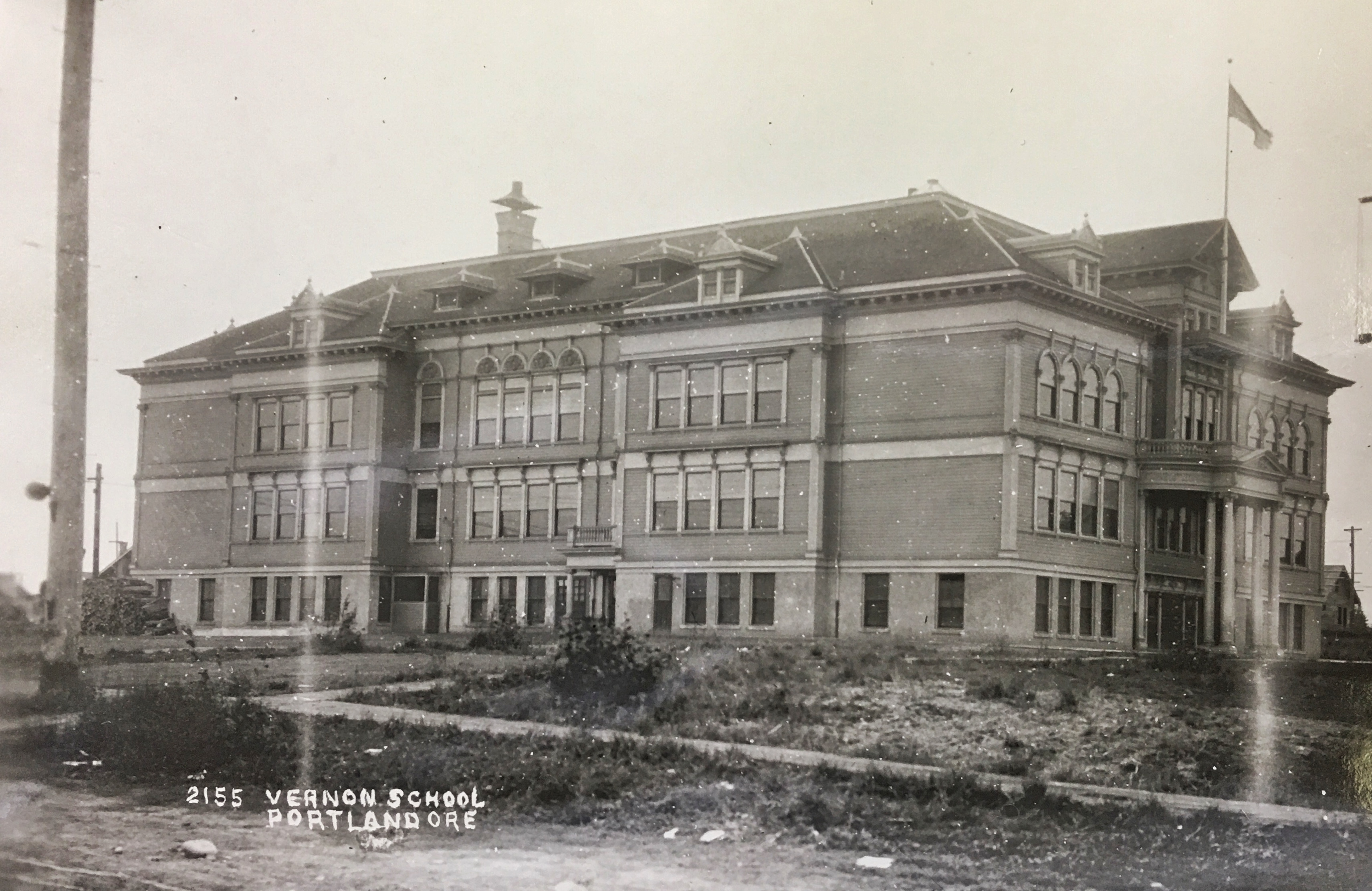
The original Vernon School, built in 1907-1908, was located on the block bounded by NE 23rd, NE 22nd, Going and Wygant. This view of the school’s south side is looking north-northwest about 1912. The main entrance was on the north side in the center. Photo courtesy of the Oregon Historical Society.

As a public school, it was both cornerstone and hearth for the community. During the day, Old Vernon was filled with the neighborhood’s young people: in class, outside on the grounds, in the portables, in the “manual training” rooms, walking home for lunch. In the evenings, every community group, service club, parent gathering, neighborhood concert, tea, dance, or lecture drew people from the surrounding blocks into the building. It was a place and institution that connected people to each other.

Vernon School Art Classroom. Courtesy of Oregon Historical Society.

There was the sadness at the end of its time. Many families didn’t want to leave the big old building and its traditions in favor of a promised new brick school a half-mile away.

And then there was the way it went: destroyed by an arsonist on a hot summer night with the entire community looking on, in fact, jamming the streets as they streamed in to watch, unwittingly hindering the fire department’s three-alarm response.


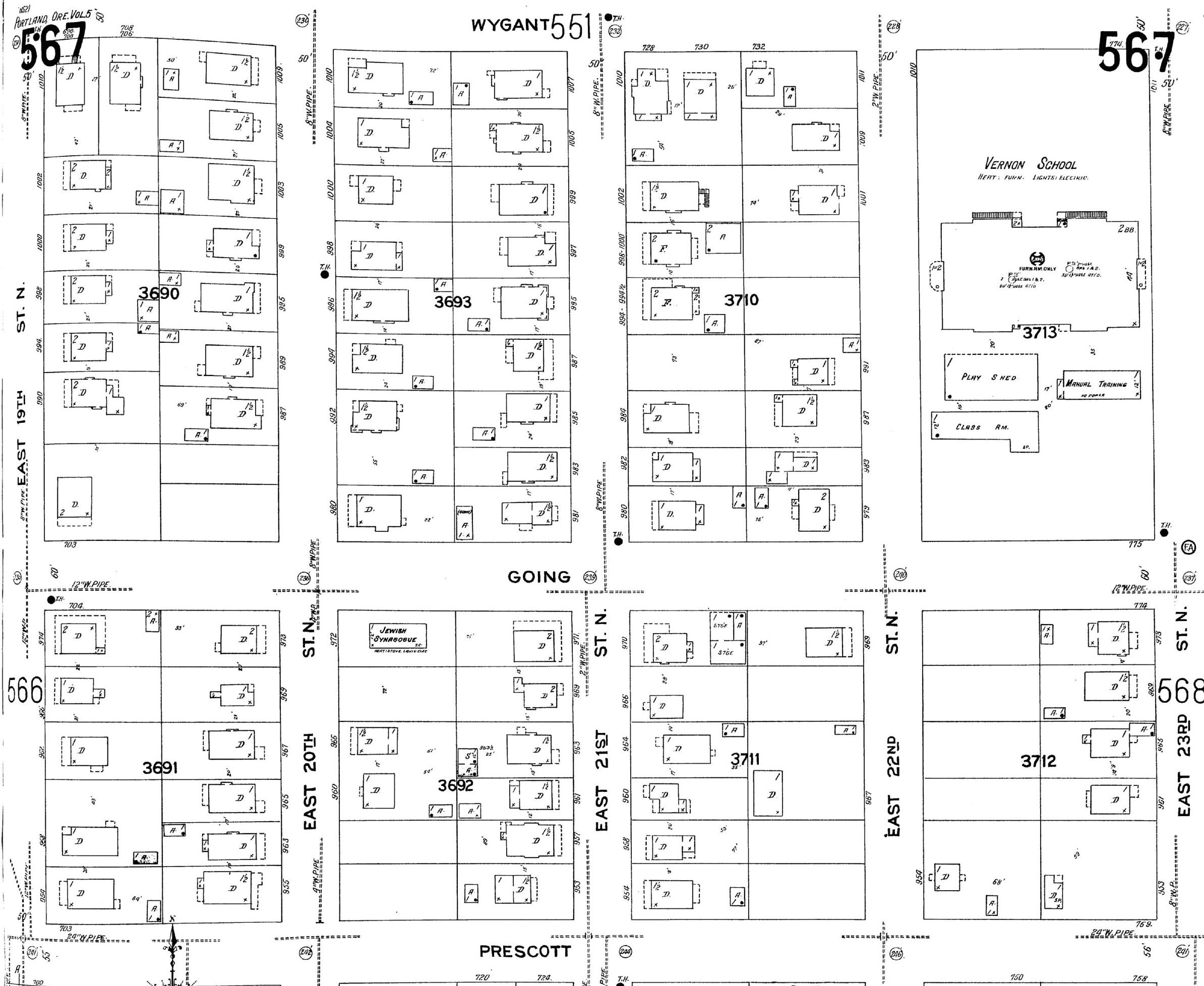
You probably know the vicinity of the old Vernon school south of Alberta Street, but you probably never knew it was there, occupying all of Block 54 of the Vernon Addition, bounded by NE 22nd and NE 23rd between Going and Wygant. Old Vernon was a giant, imposing wood frame building that commanded the center of the block, its main doors and prominent stairs facing north. The auditorium took up the entire top floor, tucked in under the hipped roof, dormers letting in light all the way around. Periodic construction added space over the years, eventually 17 classrooms in the main building, and several outbuildings for shop, cooking and a play shed. It was a big place.


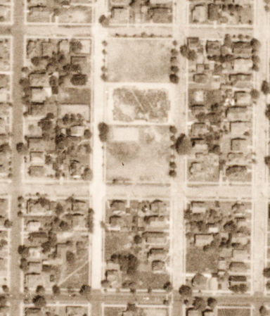
Sanborn panel 567 from 1924 shows old Vernon School and its outbuildings in upper right corner occupying the full block. Click on image for larger view.

Today, if you walk that block—as we have so many times looking for clues and trying to imagine the big old barn of a school—you’ll see how the brick and Cape Cod-style homes and duplexes on today’s Block 54 are different from the Craftsman and Old Portland style houses across the street built three decades earlier. Now you’ll know why.

After Old Vernon was abandoned in 1932, the school district tore down the wreckage and traded all 18 vacant lots of Block 54 (plus $2,000) to a developer for six lots adjacent to Thomas A. Edison High School, which during the 1930s-1940s occupied the corner of NE Beech and Mallory. This seems like a sweetheart deal to us, and we note the Portland School Board was split on the sale when they approved it on the night of April 11, 1940. Soon, new home construction was underway on the Old Vernon site, which was then fully built out with the houses we see today by 1945, erasing all traces of the old school.


The early story of old Vernon School is much like other eastside neighborhood schools. A building boom followed the 1905 Lewis and Clark Exposition, which put Portland on the national map as a desirable place to live. Open lands within four miles of downtown were bought up and platted for new development. Streetcars were the arteries of progress. And as people moved into the new neighborhoods they pushed for schools and parks.

Old Vernon opened as an eight-room school on September 15, 1908 with 324 students, many of whom were exports from Highland School (today’s Martin Luther King Jr. School at NE 6th and Wygant), which had overflowed with more than 700 students. By 1909, The Oregonian reported Vernon itself was already crowded and plans were being made to add 10 more classrooms, a covered play shed, three portables and a manual training (shop) building.

By 1914 Block 54 was a campus of four buildings, bulging at the seams with new students. Enrollment boomed, with more than 800 students at Old Vernon by the late teens. Meanwhile, plans were being made to build other nearby schools to take the pressure off and create closer-to-home options for local youngsters. Kennedy School on NE 33rd was opened in 1915 as part of this push.

Glimpses of life at Old Vernon can be found in recollected memories and newspaper clippings, including these postcard-like tastes:

“Many of the children who attended Vernon School helped in the barn prior to school each morning and weren’t always too careful about cleaning the manure from their shoes.”

“In the early years, there was one playground for the girls and another for the boys.”

“The old school had electric lights in the hallways, the principal’s office and the gymnasium where community programs were scheduled in the evenings. The classrooms had no lights. In the wintertime, when we lined up in the basement before going to class in the morning it was gray, almost too dark. If it got too dark in the classroom, we sang or listened to stories. This was good. We learned to listen.”

After arriving at school first thing, children stowed their coats in cloakrooms then lined up in the basement before marching in straight lines to their classrooms while a teacher or student played the hallway piano. One student remembered that if you stepped out of line, “you got the stick.” Old Vernon’s favorite march-to-class song was the Percy Grainger tune “Country Gardens” (which you have heard before even though you may not know its name).

“Students could roller skate or play games under a play shed in the back of the school, unless the piles of newspapers collected for periodic paper drives were too large. That was about the only time boys and girls could mingle with each other outside the classroom. Even cloakrooms were separated.”

“One teacher in a top floor classroom permitted her students to climb down the outside fire escape—quietly to avoid disturbing other classes—as a treat for being especially good.”

“Old timers recall a disciplinary ruckus which had strong repercussions in the community. This involved an older boy who defied the principal’s efforts to take him to the office. A wrestling match on the stairs between boy and principal [they reportedly fell down the stairs injuring the boy] spurred a pupil walkout, and the boy’s parents pressed charges. A hearing board exonerated the principal, but teachers and principal were reluctant to use severe punishments afterward.”

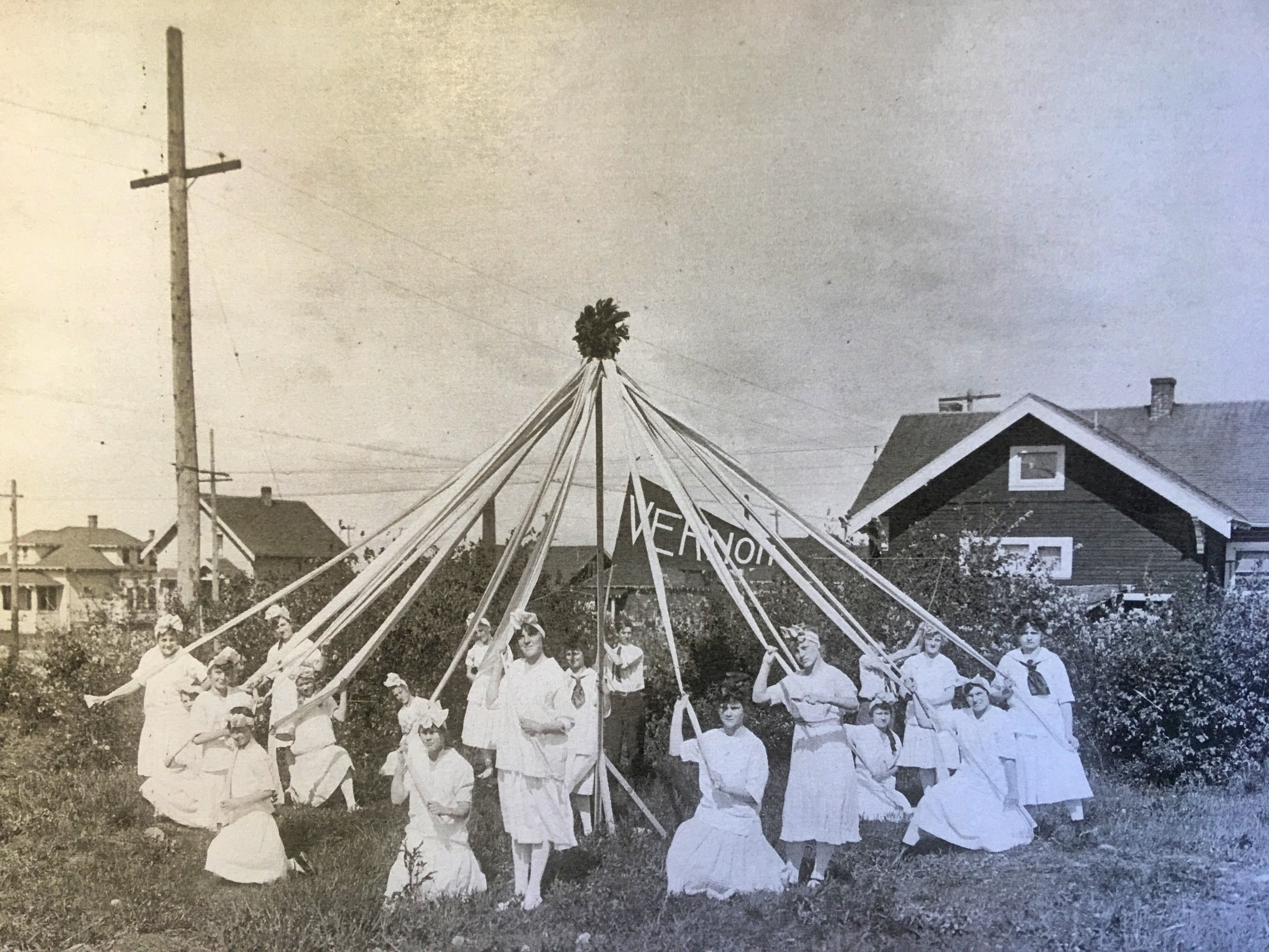
Year after year, students from Vernon School won the maypole dance competition during Rose Festival:

Maypole dancers from Vernon School won first prize at the Rose Festival in 1911. Photo courtesy of Oregon Historical Society.


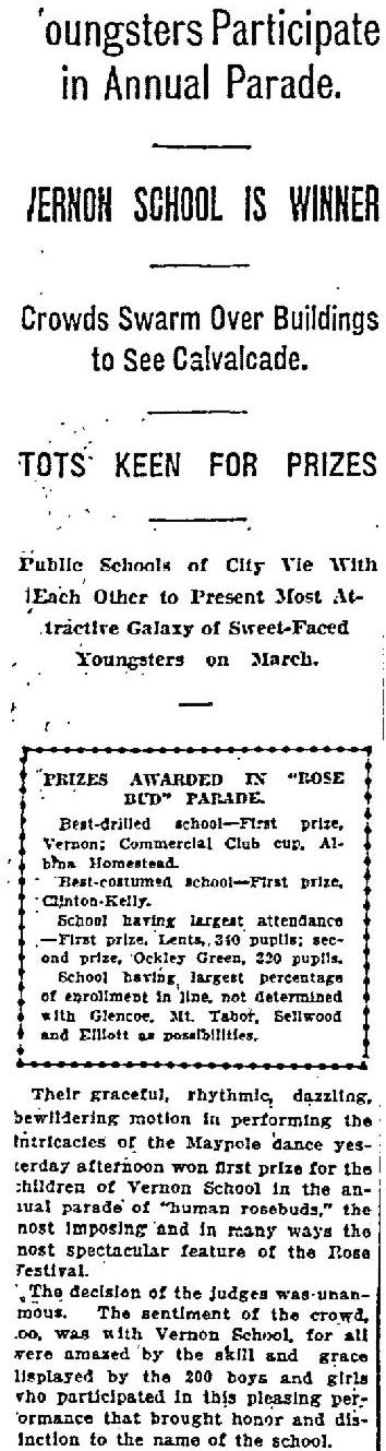
The Oregonian, June 10, 1911


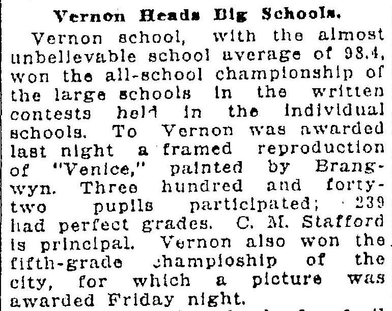
Apparently, Old Vernon’s academics were as strong as their maypole dance:

The Oregonian, April 3, 1927


By 1926, trends in school construction, safety and changing demographics were shaping the next generation of area schools.

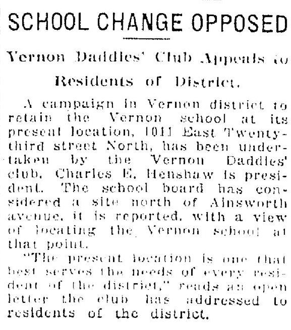
Disastrous school building fires in other cities had galvanized the national building codes community—and Portland Mayor Harry Lane—into calling for “fireproof” buildings. Code changes were made: away from wood frame to concrete, steel and brick, and lowering the profile from multi-story to one or two stories. In 1926, some school board members proposed abandoning the existing building and locating a new Vernon School close to Alberta Park, an idea that didn’t go over well in the community. An article in the April 14, 1926 edition of The Oregonian chronicles opposition from the Vernon Daddies’ Club, a position they developed and had approved at a school-wide parent meeting:

The Oregonian, April 14, 1926

But the Daddies’ Club and the Vernon school community were on the losing end of the argument.  By 1927, the school board was on the hunt for property and wanted the city to carve off the southern five acres of Alberta Park on Killingsworth between 19th and 22nd for the new school site. The community pushed back on this—whether to protect the park or because they just didn’t like the idea of losing Old Vernon we’ll never know—and was upheld by City Attorney Frank S. Grant, with a finding on October 15, 1927 that Alberta Park, which had been acquired through condemnation in March 1921, must be protected as park land and not used for a school

After being spurned by City Attorney Grant at Alberta Park, the board focused on a two-block area across the street, bounded by Killingsworth, Emerson, 20th and 22nd, where almost two dozen homes had already been built and 13 vacant lots were ready for more home construction.

A late-night meeting of the school board on December 2, 1929 heard several hours of public testimony on the acquisition, and according to The Oregonian, spiraled into “a sharp verbal combat between the directors,” but ultimately resulted in direction to move forward on the Killingsworth property. Gaining this site for a new school meant major work for school district staff, which they took on, eventually acquiring the property, demolishing the homes and getting the city to vacate NE 21st Avenue where it bisected the site. This took two years of wrangling.

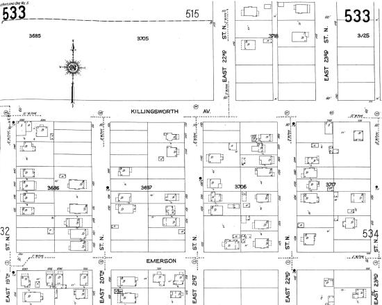
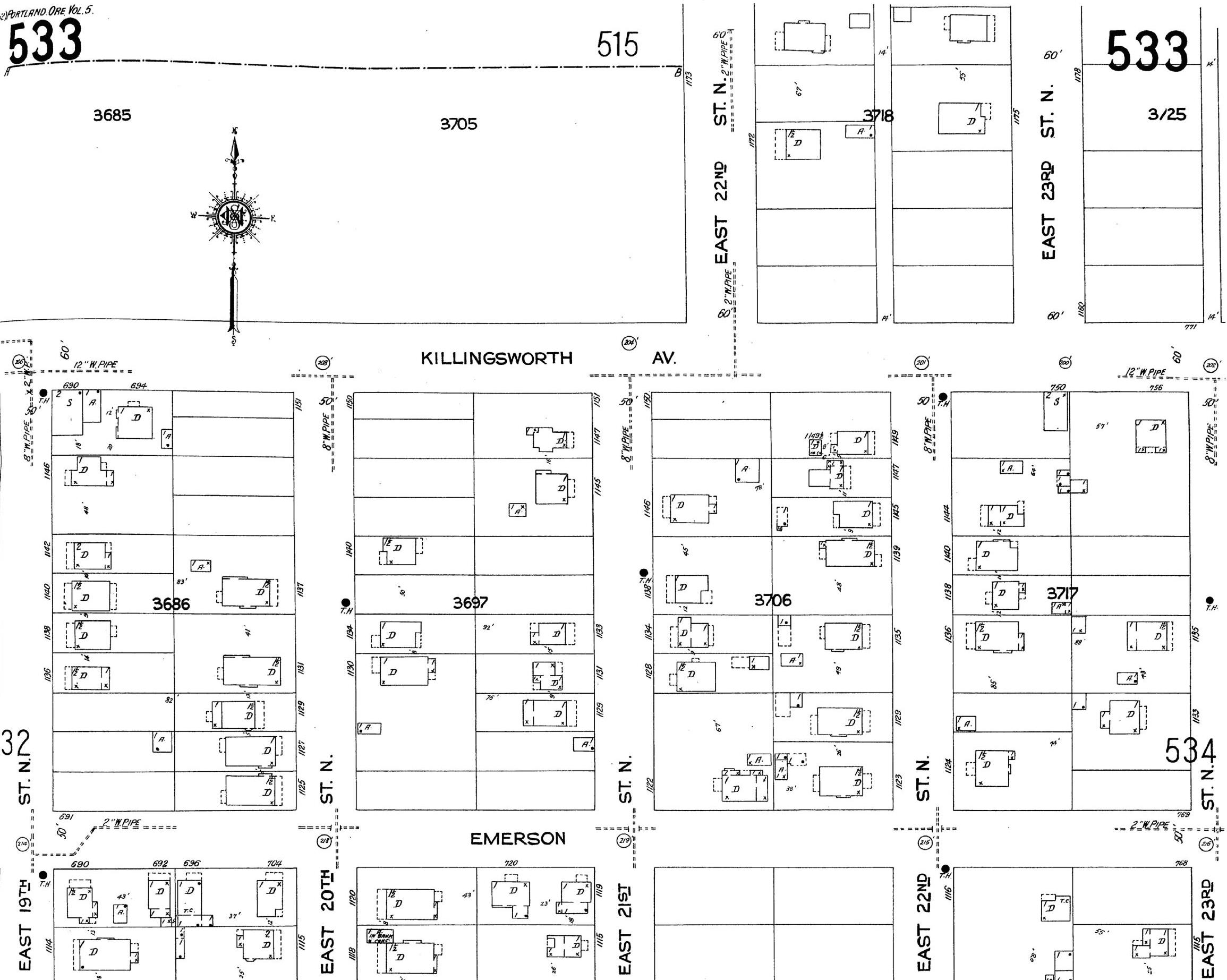
Sanborn panel 533 from 1924 shows the area of today’s Vernon School prior to acquisition by the Portland School District. Today’s Vernon occupies the two blocks between 20th and 22nd, bounded by Emerson and Killingsworth. The large empty block at the top left is Alberta Park. Click on image for a larger view.

Meanwhile back at Old Vernon, students continued to fill the aging, creaking classrooms, play outside in the sheds and open fields, and gather in the top floor auditorium. The city granted authority to temporarily close East 22nd Street during the school day so students could play in the street. Community clubs, concerts, lectures and Boy Scout troop meetings continued–the headquarters of Troop 33 was the Old Vernon basement.

On April 8, 1930, after acquiring the Killingsworth property, the school board auctioned off the remaining abandoned houses.

A $250,198 contract for construction of new Vernon was awarded on July 6, 1931 to F.S. Starbard and Company of Portland, and activity began on the new site targeting a September 1932 opening.

In March 1932, with construction going full steam, school leaders planned to mark the coming transition and perhaps heal the community with one last big gathering at the old school that would be both homecoming and forward-looking celebration. There’s no one around to ask how that went, nor any reporting that might reveal what that last evening was like, so that’s one for your imagination. Here’s the preview story:

The Oregonian, March 8, 1932

A cornerstone ceremony and time capsule placement was held at the new building on June 6, 1932 with all 500 students from Old Vernon looking on and checking out what was about to become their new school.


With school dismissed for the summer of 1932, the Portland School District had options. For the first time—with new buildings coming on line—they didn’t need to jam students into every available building space. Facility planners could contemplate the next move with properties. Bids were out for demolition of the buildings now empty on Block 54, but there was no hurry: New Vernon over on Killingsworth was ready.

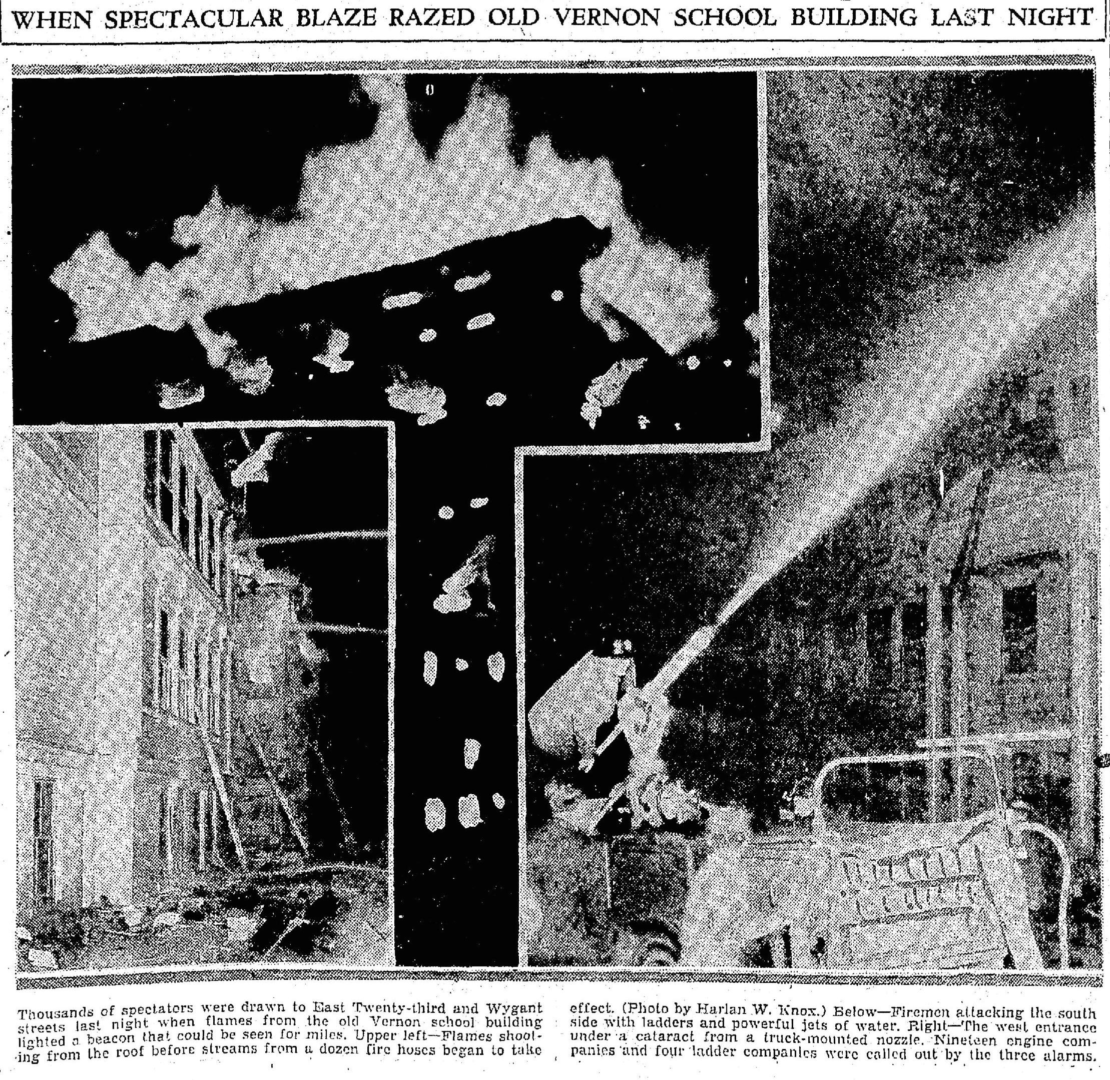
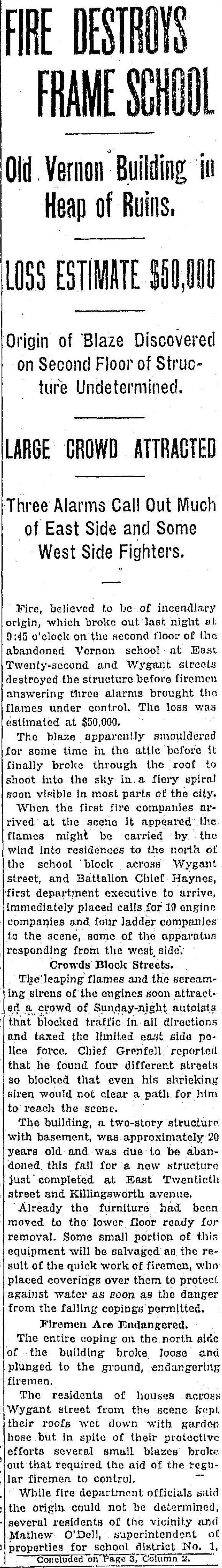
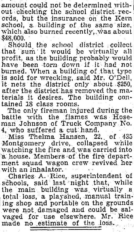
Just after dark on Sunday, August 14, 1932, someone broke the glass in a basement door and let themselves into Old Vernon, ascended the stairs to the second floor, and set a fast-moving fire that lit up the night sky for miles. The three-alarm fire drew thouands of spectators and 19 engine companies. The morning newspaper was delayed to include the news. The Oregonian was swamped with calls resulting in an explanation for the delivery delay in a prominent boxed message on the paper’s front-page masthead: “Pardon Us – But our telephone exchange was swamped when the Vernon School burned.”

Front page breaking news coverage on Monday the 15th, and a follow-up story about the fire investigation on Tuesday, August 16th, tell the grim story:

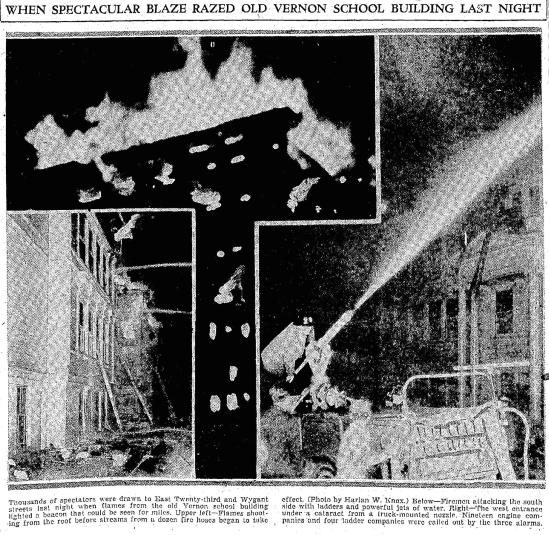
The Oregonian, August 15, 1932

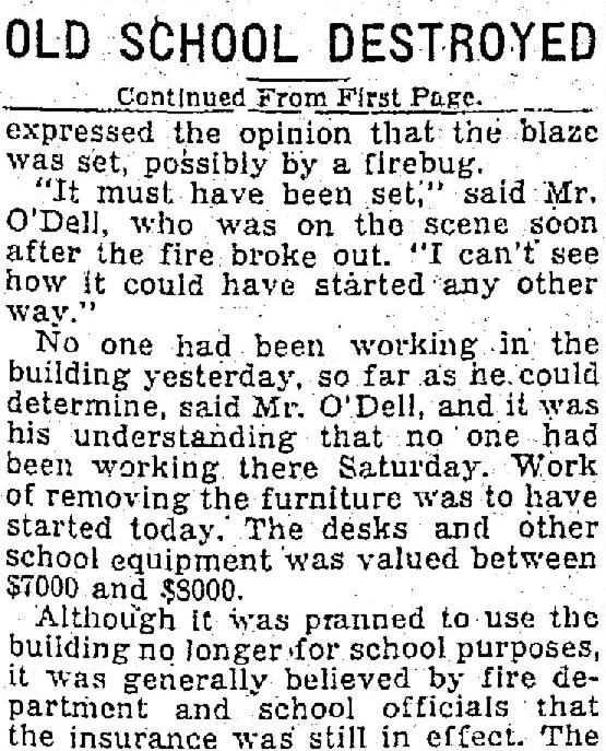
On Tuesday, the story had moved inside the paper to page 6 for more details on the investigation and cause:

The Oregonian, August 16, 1932

A year-long battle with the insurance company followed while the burned hulk of the building sat untouched. Originally insured for $70,000, the insurance settlement paid only $31,039.41 with underwriters arguing the building had been abandoned and that arson changed the equation. In March 1933, the board let a contract to Rose City Wrecking for $100 to demolish and haul off the remains, though the manual training building and the portable were salvaged and removed. The site was cleared by June 1933. Construction of new homes on the site began in October 1940.

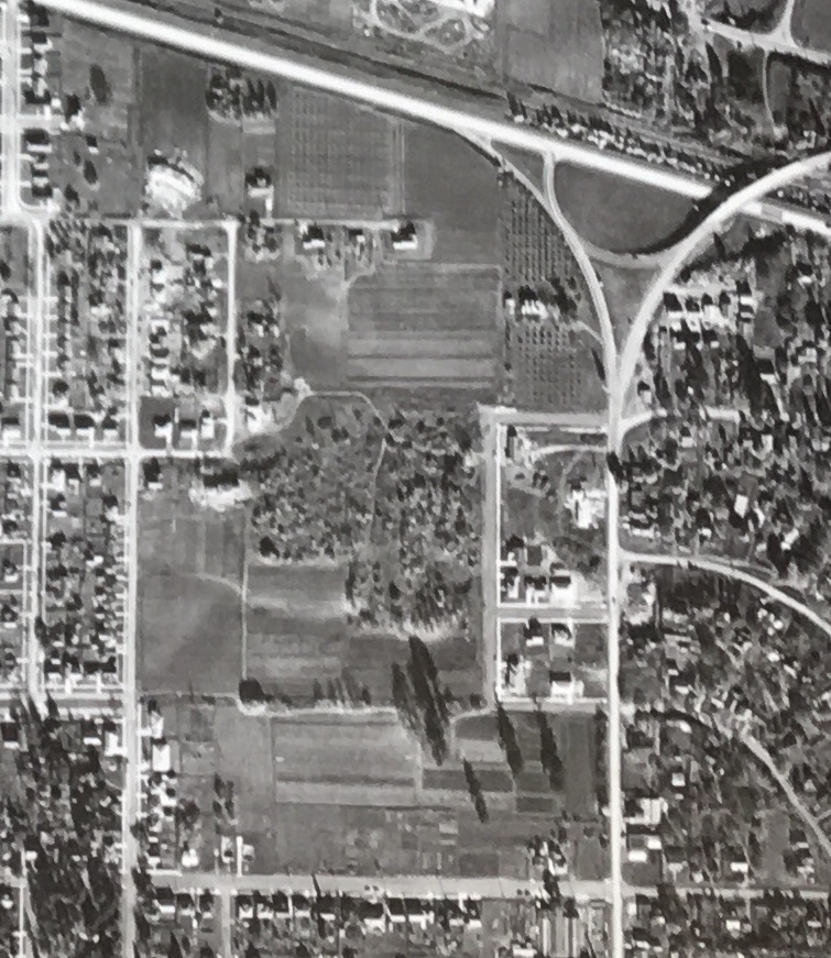
Detail of an aerial photo from 1936 showing vacant Block 54 and the burn scar / footprint of old Vernon School. NE Prescott runs east-west along the bottom of the frame.


It’s hard to read the dozens of newspaper stories between 1908-1932 about the vibrancy of Old Vernon and what it meant to the community, and not want to slow things down a bit, to hear more from the decision makers, to ask a few more questions of the neighbors, to see what we might be able to work out on Block 54. Eventually, all of the multi-story big-barn type schools built in Portland between 1890-1915 either burned or were replaced. Neighborhoods changed, as they continue to do today.

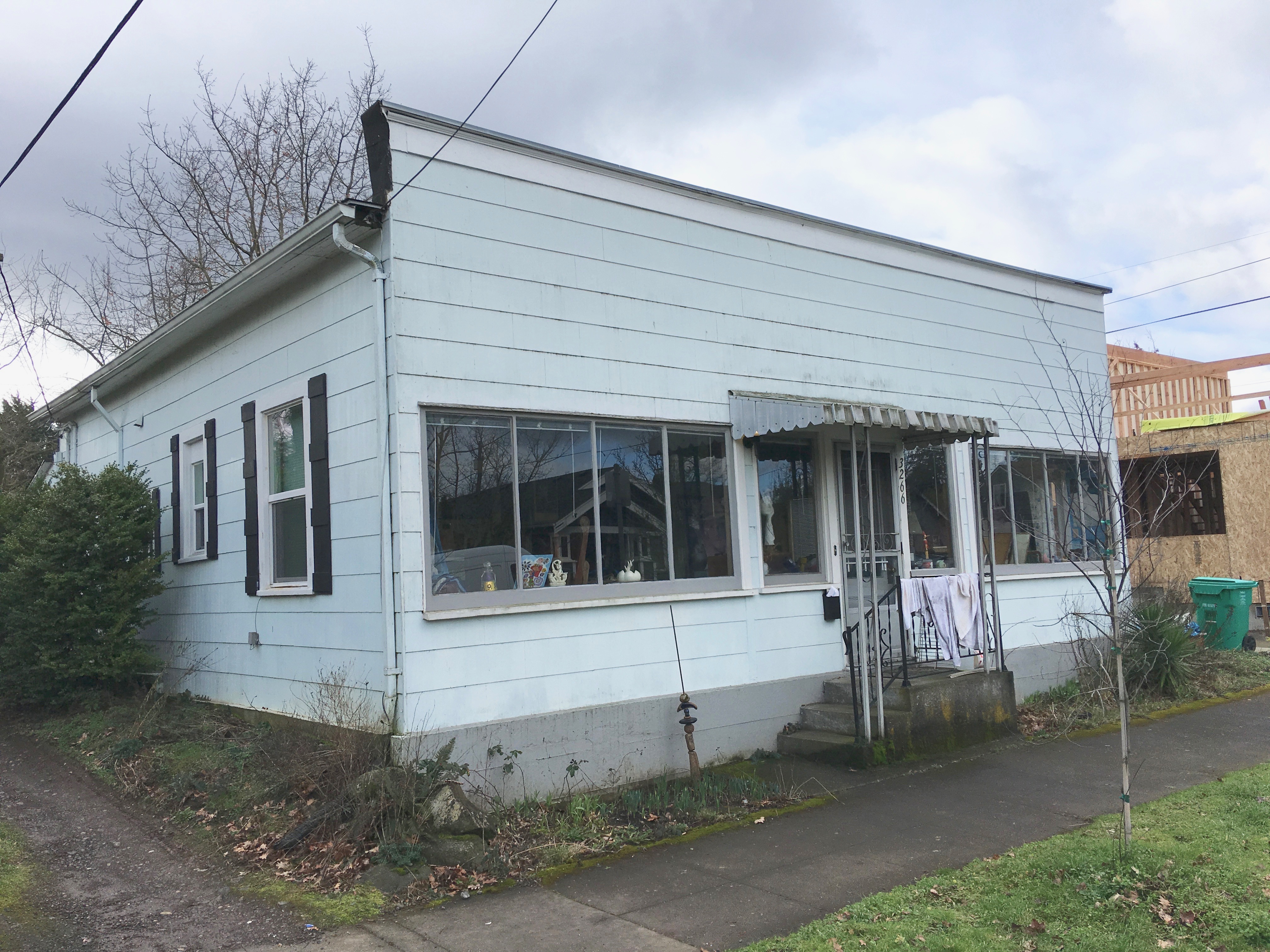
Two time travelers still around from the Old Vernon era are nearby houses leased by the school to teach girls and boys about home economics. In our next post we’ll share photos and stories about how these houses gained national notoriety for Portland as an innovative education pioneer, and what the house can tell us today.

Gone but not forgotten

It’s been gone since mid-October when the orange excavator took the house to the ground and dump trucks carted it away as debris, but the Kettleberg house that was demolished at Northeast 30th and Skidmore has not been forgotten.

George and Manila Kettleberg home, built 1921. 2933 NE Skidmore. From The Oregonian, September 11, 1921.

George and Manila Kettleberg home, built 1921. 2933 NE Skidmore. From The Oregonian, September 11, 1921. The Kettlebergs lived there for almost 50 years; their daughter Dorothy and husband Walter lived next door.

Neighbors still shake their heads as they look at the hole in the ground and remember the 1921 Craftsman bungalow that stood on that spot for 95 years. We’ve talked to a few who still can’t believe two 3,000-square-foot houses will be built in its place. Some neighbors still refer to the corner as Willis and June’s, even though Willis moved away when June passed on a few years back and no one has heard from him since.

According to the City of Portland, the house’s address 2933 no longer exists. A search of portlandmaps.com shows the planned locations and permitting for the two new buildings that will occupy that lot, now known as 2945 NE Skidmore and 4305 NE 30th. We tried to have a look online at the historic plumbing permit for 2933 the other day, but it’s gone now too.

The house is still alive in memory, though. Last week we received a note from George and Manila Kettleberg’s great grandson Robert who explained to us that his grandmother Dorothy and her sister Nancy grew up in that house. George and Manila bought the house brand new in 1921, and raised their girls there.

In the early 1950s daughter Dorothy and her husband Walter moved in two doors down. And then a few years later, Dorothy and Walter moved in right next door to her parents George and Manila. That end of the block wasn’t like a family, they were family. Life flowed back and forth between those three bungalows.

Robert remembers his dad saying it worked out pretty good for him because he could always run between the houses to see who was serving the best dinner. Many footprints left back and forth between those houses.

Construction in the big hole hasn’t started yet, but we’re guessing by spring there will be plenty of activity. Two new big places will go up crowding the lot. Then it will be up to us neighbors to keep the stories of Kettleberg corner alive: almost 50 years of one family’s life.

That’s the thing about old houses. They remind us of who we’ve been; they keep us connected to places our families have known intimately; they contain the passing of time.

Backstory of a favorite local fire station

Picking up the local fire station thread where we left it: here’s a story about how the siting of public facilities in the early days was more about administrative prerogative and less about public input. Portland Fire Station 14 as we know it today is one such story.

station-14

Portland Fire Bureau Station 14, NE 19th and Killingsworth

In 1958, with the closure of the old fire station on NE 33rd and with a new fire chief in place, Portland set about reconfiguring its overall fire response network. Several of the older smaller stations across the city were closed. New stations were planned. A $3 million bond levy passed by popular vote, and seven new stations went into development across the city, serving (and changing) the neighborhoods where they landed.

Fire officials wanted something more central to the Concordia neighborhood, and they didn’t mind something that would also be expedient. Those criteria focused planners on a parcel the city already owned: a quarter-acre at the southwest corner of the popular 16-acre Alberta City Park, bounded by Killingsworth on the south, Ainsworth on the north, NE 19th on the west and NE 22nd on the east. It’s a great park.

From an expediency standpoint, this made sense: lots of surrounding housing that needed fire protection; it was near a school that would also benefit from quick response; it was on a major east-west thoroughfare for good access. Not quite like building a tennis court or swimming pool, but doable.

Problem was, there wasn’t much conversation with the neighbors.

3-4-1959-construction-men-enter-park

The back-and-forth between the city and the neighborhood that followed would give even the most veteran city PR person the heebie-jeebies. Articles in The Oregonian from July 1958 until March 1959 describe how the neighbors opposed construction at first politely, which ratcheted up to petitions signed by 400 neighbors and sit-in protests against the station by the Vernon PTA, letters from the pastor at the Vernon Presbyterian Church, formation of a lobbying group called “Save Portland Parks,” a strident letter writing campaign by neighbors, and—after the city decided to go forward with the project even in the face of local opposition—an arson attack on the construction site on the night of March 3, 1959. Yes, you read that correctly.

The opposition group leader eventually gave up when the city persisted: “We don’t like it, but we can’t do any more,” Dorothy Rapp told The Oregonian on March 5, 1959. “It’s fruitless to fight city hall any longer. There’s no sense in beating our heads against the wall.”

Today, Station 14 has become part of the fabric of the neighborhood, welcomed and appreciated by all, or at least taken for granted. The engine and four personnel stationed there respond to 2,500 calls for service each year.

We’ve overcome this particular history (and hopefully learned from it), but as we know, it’s always insightful to remember how things came to be.

It’s Snowing on Deadman’s Hill

Whenever it snows, Alamedans of a certain age and desire for adventure turn to Deadman’s Hill at the top of Stuart Drive for some enjoyable downhill adventure. It’s also a reasonable time for us to remind ourselves of the dead man for whom our hill is anonymously named.

6-6-1917 Fred Jacobs PhotoFred Jacobs. The dead man behind Deadman’s Hill. From The Oregonian, June 6, 1917.

He was Fred Jacobs and his tragic death at the foot of the hill on a sunny June morning in 1917 sent shock waves through Portland’s social and real estate communities, as well as the Alameda neighborhood.

You can read our full story behind Deadman’s Hill on this earlier AH Blog post.

While you’re at it, you might check out a post we did on historic snowfall a few years back.

Stay safe out there!

%d bloggers like this: