Time travel at 15th and Killingsworth

We came across a great old photo recently of a proud apron-clad businessman standing, arms crossed, in front of his market at the corner of NE 15th and Killingsworth. It’s a photo worth having a look at. We’ve been staring at it for a while to puzzle through some of its riddles.

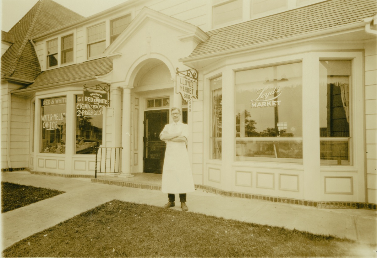
Photo courtesy of Portland City Archives, image A2008-001.39

First, there is no identification. Who is this proud man? Second, there’s a spelling conflict: is it Loyd’s (as the window suggests) or Lloyd’s (as the shingle suggests), and how did that happen? What did Loyd’s sell? And when you really look at the picture you understand it’s actually two businesses: Gwaltney’s Red and White Market where the watermelons and cigarettes are for sale, and Loyd’s (or Lloyd’s, depending on which sign you read). Can you hear the spring in the screen door when it opens, and the door smacking back into the frame as it closes?

We do know where it is: the southwest corner of Killingsworth and 15th. Loyd’s was 608 and Gwaltney’s was 610. After some research, it became clear to us that the main entrance to Gwaltney’s was off the picture to the left, at the corner. More on that in a moment. These addresses translate to 1478 Killingsworth today. Remember, all of Portland was readdressed in 1931, so we know this photo was taken before that. We’re guessing 1929-1930. Built in 1927, the building still stands. A look back through permit history shows many chapters and changes: market, pharmacy, restaurant, tavern, pool hall, rented rooms upstairs, and now office space.

Here’s a look at that same view today. The portico is gone, the front of the building looks like it has been pushed out a bit, the grass is gone and Killingsworth has been widened, putting the early vantage point almost into the street. See for yourself:

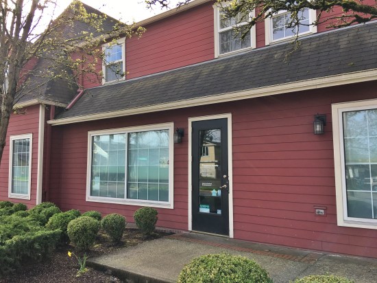
1478 NE Killingsworth, March 2017

Next is the question of who this gentleman is. We believe this is actually Mr. Loyd in front of his store, not Mr. Gwaltney (who would have been posing in front of his own front door somewhere off the picture to the left). With the help of the Polk City Directories, census records and a few other genealogy tools, we believe this man is John F. Loyd (only one “L”). From 1929-1939 he ran a meat market at this address. For some of those years his son Clarence helped out in the shop. Loyd lived on Dupont Street near the Broadway Bridge (now gone under the Portland Public Schools building–Dupont no longer exists) with his wife Alma and children Clarence, Ruby and Lester. He was a WW1 veteran. John and Alma were born in Sweden and immigrated to the US in 1900.

Willis H. Gwaltney was the shopkeeper at the Red and White Store, off to the left. Gwaltney and his wife Martha lived just around the corner on NE 16th. He spent a career in the grocery business, his last assignment being at the Kienows on SE 39th and Lincoln. In the 1930s, Red and White markets were everywhere. Each was independently owned: shopkeepers could buy Red and White branded merchandise, marketing materials and even store shelving. In the mid 1930s, there were 6,700 Red and White markets nationally. We had several in the neighborhood…more on that in a future post. Gwaltney’s shows up in the Polk City Directory at this address from 1929-1933, when Willis moved on, likely a victim of the changing economy.

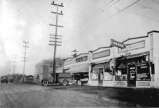
While out taking pictures of this building, which in 2017 is the home of Portland/East Metro Habitat for Humanity, we decided to knock on the door and share this picture with the current occupants. The very friendly Tim, who was at the front desk there, was welcoming and excited to see Mr. Loyd. Tim wanted to share an old picture of his own and took us into the back room to see a large format framed photo of the building hanging on the wall, shown below. The timeframe for this one is a bit later.

The Oakhurst Pharmacy is listed in city directories from 1940-1948, and if you look at the passerby’s hat, the ads in the window, the style of street sign, that timeframe fits. Gwaltney’s is gone. Lloyds is gone and the “welcome to my front door” sense of entering the building on that side has changed, Mr. Loyd’s proud perch now covered up with an awning and boxes. The street has been widened and grass replaced with concrete. Looks like they must have had a leaky roof too, the valley of that far gable reinforced with flashing. Here it is:

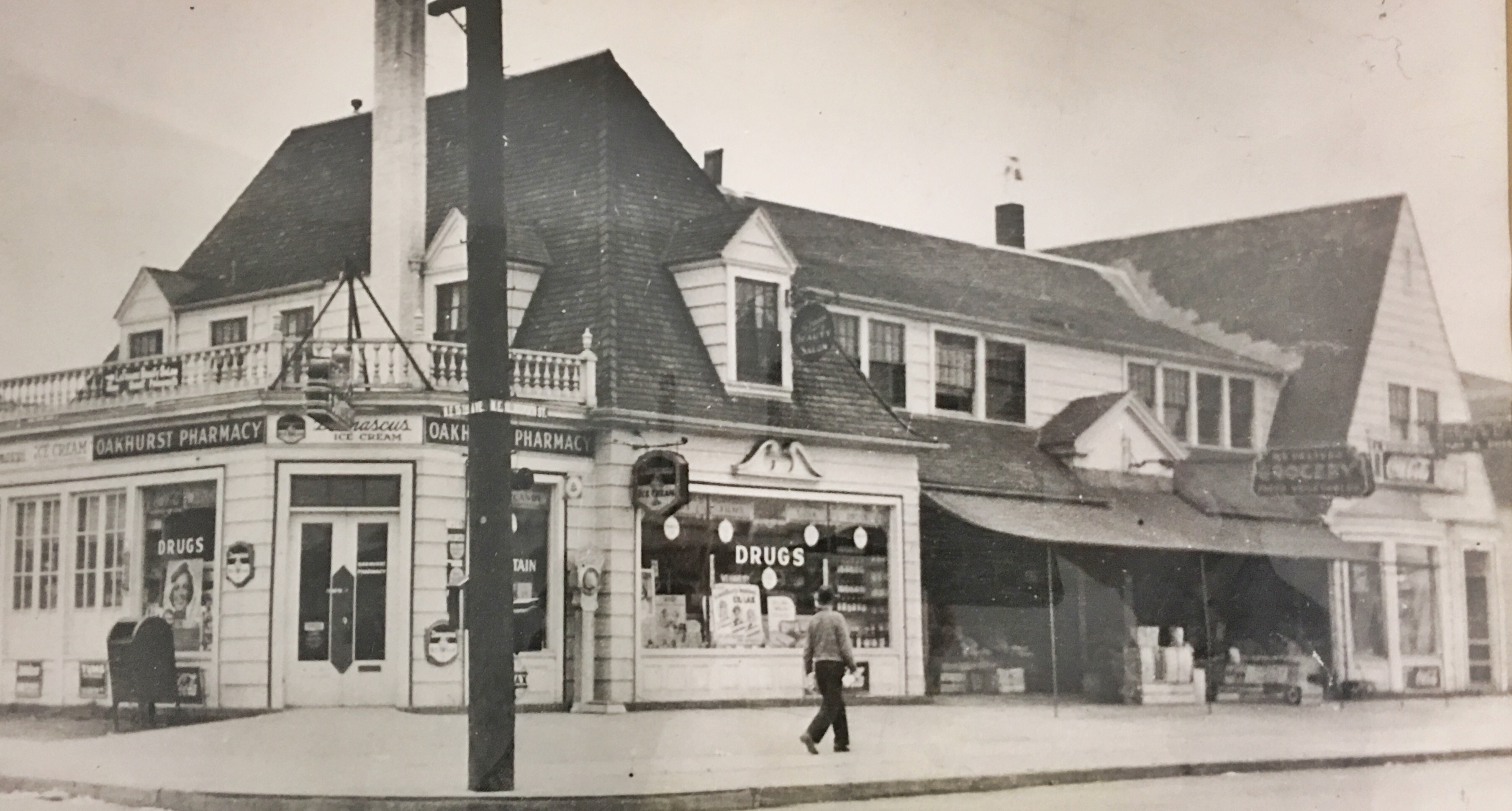
1478 NE Killingsworth, about 1945. Photo courtesy of Habitat for Humanity Portland/East Metro
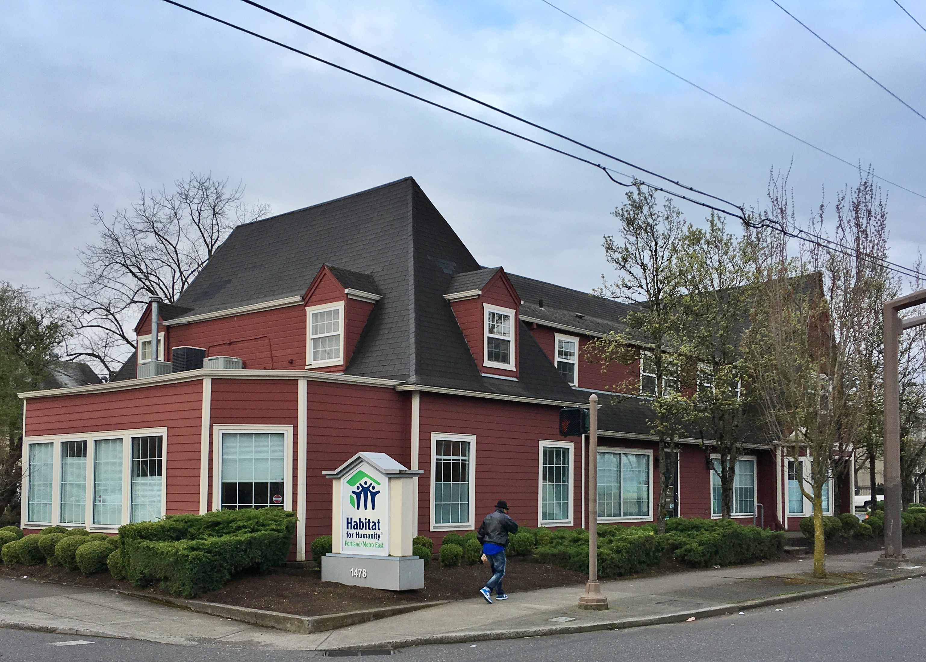
March 2017

Oakhurst, by the way, is the name of the platted addition just west of the Vernon area between Killingsworth and Ainsworth from 14th to 19th, originally platted in 1892. We’re betting that name has faded away like so many of Portland’s other plats. Have you ever heard someone talking about Oakhurst? We haven’t.

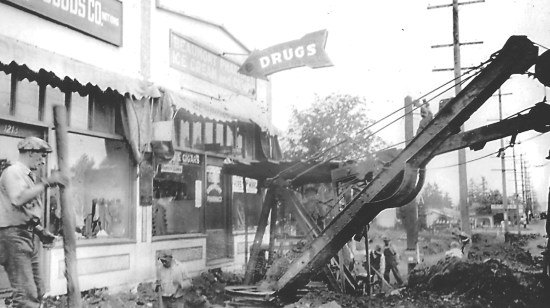
Back then, Lee Witty was proprietor of the Oakhurst Pharmacy and he must have been a resilient person: the pharmacy appears multiple times in The Oregonian during his eight years in stories about several armed robberies, a fire that damaged part of the building, and even a major accident in March 1947. Check it out:

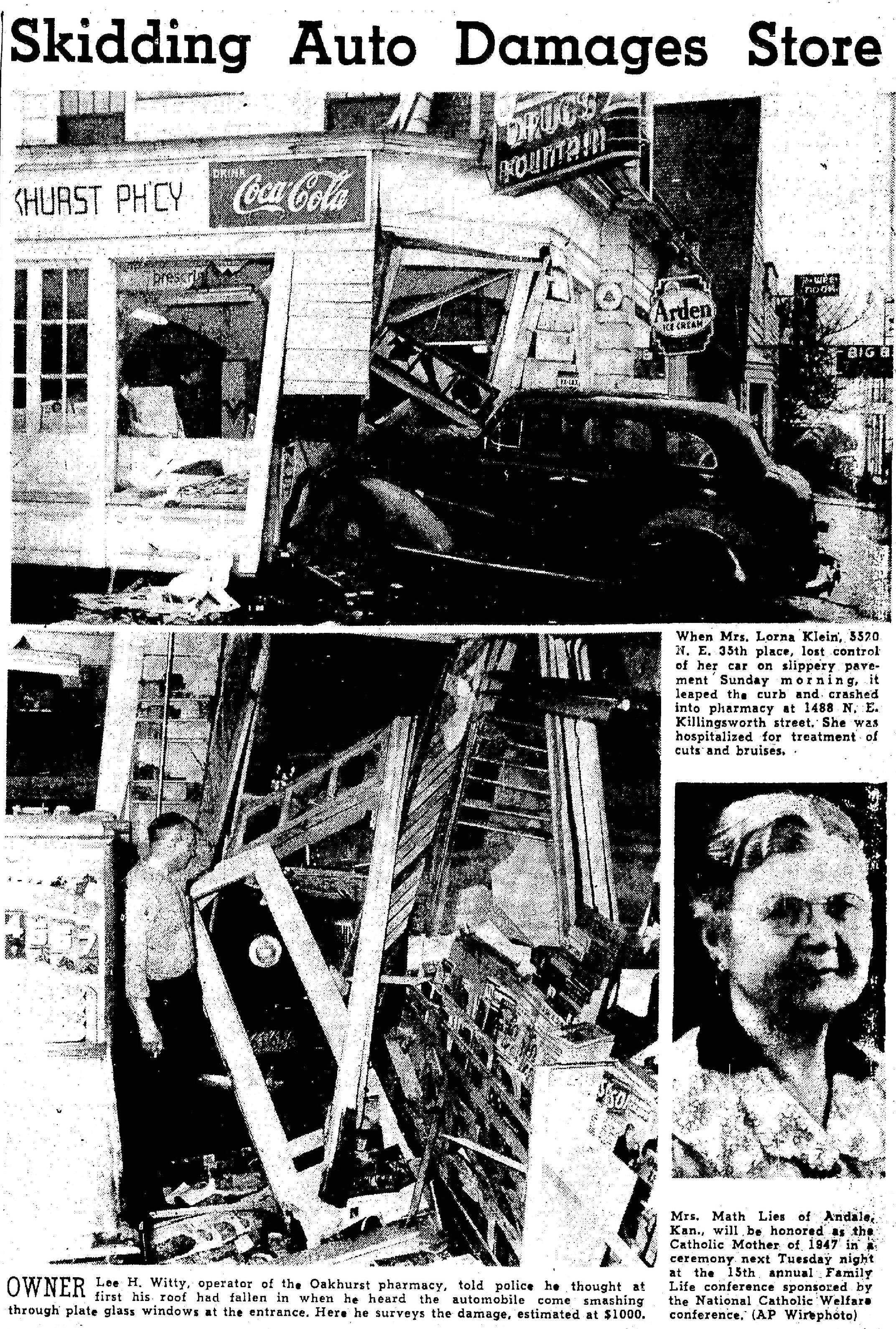
From The Oregonian, March 10, 1947

How much longer will this building last? Good question. It has certainly seen its share of change. Uncovering its story, like all the research we do, is about as close to time travel as we can get.

Old Vernon Part 2: The Practice Houses

Scattered and unidentified in File 1856 at the Oregon Historical Society are pictures of young people preparing food in an old house kitchen and lined up on a front porch looking very determined in their white aprons.

The pictures are piled into a dog-eared manila folder containing random old photos of schools in north and northeast Portland, so at first glance they seemed out of place. Why was a house in the school folder? The photos did have the name “Vernon” written on the back, but they were clearly of a house, not a school.

We made copies of these photos anyway and kept on in our search for information on the old Vernon School. That’s one of our rules of research: you never know how all the parts might fit together, so keep an open mind and gather up the pieces because eventually they might make sense, and you’ll need them to complete the puzzle.

As we’ve learned more about old Vernon School—which occupied the entire block bounded by NE 22nd and NE 23rd, Wygant and Going from 1907-1932—we found references to two different nearby houses, rented by the school board at different times, that provided a learning laboratory for “domestic science.” These insights helped us make sense of the photos.

Launched by Vernon School Principal William Parker, the program started in 1914 in a rented house at 4715 NE 24th (rent was $18 per month) where it ran under the supervision of Mrs. Caroline Redding. References in The Oregonian and a handful of national magazines referred to it then as the Vernon Community House.

In 1917, the program shifted to a different teacher—Mrs. Lois Swafford—and a different house, this one also rented, at 4545 NE 21st. This house was referred to as the Vernon Practice House.

Regardless of which house or what it was called, Vernon’s community-house-practice-house was a pretty resourceful little institution. Students built the furniture, dug, planted and weeded the vegetable garden, made the drapes, sheets and linens, planned and made the meals, planned household budgets and hosted dozens of teas and gatherings to practice their domestic arts. They developed systematic approaches to cleaning and maintenance. Principal Parker dubbed the insight and experience this created as “homecraft,” the art of running a household. Students had the responsibilities and the learning rewards of figuring out how to run a two-story, six-room house; to practice at some life skills that might come in handy down the line.

Over a period of four years between 1914-1918, old Vernon School was a kind of educational mecca visited by leading lights in the education world and the national press to see what this learning-by-doing house was all about. During those years, the neighborhood had an impressive list of visitors that included the head of the Education Department at Harvard University; Ladies Home Journal magazine; Sunset magazine; scholarly education journals; The Country Gentleman, a national-circulation magazine targeted at rural homeowners.

Here’s a July 1915 article from The Country Gentleman, that describes the Vernon Community House. Click the image to enlarge.


Below, an article from Sunset Magazine in October 1918 tells pretty much the same story of the program. Featured in the photo is the Vernon Practice House (the second of the two houses) at NE 21st and Going, which operated after 1917 under the leadership of Mrs. Lois Swafford (inset). Click the image below to enlarge.


Even though old Vernon School has been gone now for 85 years, we wondered how both houses were faring and if their residents had any inkling of the former role these houses played in the neighborhood. So with pictures in hand, we set out to find them.

Investigation by bike, some walking around, a quick look at old city directories and a pre-address change cross-reference turned up the locations pretty quickly. We wondered if the students from the 19-teens would recognize the houses today. Judge for yourself:


From The Oregonian, January 24, 1915


4715 NE 24th Avenue today

We visited briefly with the homeowner here on NE 24th, who has lived in this house for 20 years. He had no idea his house was once part of a school program or, for that matter, that there had been a school just one block over. Most people we talked to, and those we’ve heard from since posting our story on Old Vernon, had no idea of the school’s former presence in the neighborhood.


Continuing on our hunt for old houses, we found and knocked on the front door at the second Vernon Practice House, where we met homeowners Ann Gravatt and Brad Ouderkirk, who were not aware of the home’s history but were interested to learn more. Again, no indications from their knowledge of the house that it was long ago the focus of so much attention.

The second Vernon School Practice House (after 1917). Detail from October 1918 Sunset Magazine (above), and today (below).

4545 NE 21st Avenue today

We shared more vintage photos from the Oregon Historical Society file (below), which they were excited to see. Their children are about the ages of the students in the photos from 1917, which prompted Ann to ask her son if he was going to be cooking dinner for the family…

Written on the back of this photo: “Vernon School boys, Portland, Oregon, who have been learning ‘fantastic cookery.'” Courtesy Oregon Historical Society, file #1856. Our best guess is that these photos were taken by Portland Public Schools in fall 1917 or spring 1918.


When the current homeowners saw this photo: “Yes, that is definitely our dining room.” Courtesy of Oregon Historical Society, file #1856.

After several feature-length stories in The Oregonian in the mid 19-teens, and many blurbs promoting upcoming community teas, fundraisers and social events at the house (all catered and staffed by eager students), newspaper references to the house stop in late 1918. No clues in the archives, and no one to ask about what it all meant or how the Vernon Practice House ended.

Did Mrs. Swafford leave? Did the return of soldiers at the close of World War I swamp the rental market and return the practice house into actual use? We know that Principal Parker, a key leader of the effort, was at Old Vernon until 1920 when he was transferred to the Albina Homestead School at NE Beech and NE Mallory streets. Did he take the program with him when he left?

Hmm.


NE 3rd and Broadway as you’ve never seen it

One of the great joys of our research is finding the unknown—more properly the long forgotten—in the midst of the known. Photos, memories, documents and stories from the past add new understanding to places we know (or think we know), and often bring a hint of the familiar: the profile of the ridgeline on the horizon, the curve of a street, the form of a building we recognize.

Sometimes these clues from the past are unreconcilable with the landscape we know today. In the world of Northeast Portland neighborhoods, pretty much anything after 1910 will carry a hint of the familiar. Turn back the clock a bit further and those hints are harder to detect.

Case in point: this Sanborn fire insurance underwriting map from 1909 of the Eliot neighborhood, showing the vicinity of the busy intersection at Grand and Broadway that we all know. Or think we know. Have a good look and pay attention to the location and extent of the gully shown as Deep Gulch, the wooden bridges, the buildings up on posts, the row of houses with their bay windows all to the side. Check out the State Laundry Company building too, and the note about the night watchman. (If you don’t know about Sanborn maps—which were used for fire insurance underwriting—be sure to check out our post on the topic).

1-16-16 Sanborn 289 Detail

Detail from plate 289, Sanborn Fire Insurance Map, 1909

Everything in this frame from 1909 is absolutely gone today—the gully, the buildings even the streets which have been widened—and most of us speed through here (being careful about the red-light cameras) on our way somewhere else. Below is a modern view of that intersection.

1-16-16 Detail from Google Earth

Thanks to Google Maps. Click the thumbnail above for the full photo.

* * *

Ready for an even closer look? This is the fun part where we get to try to imagine the landscape that once was, and how different it is today. As you study this photo, be sure to check out the detail: the awning style shutters; the orderly clapboard and fish-scale siding; the beautiful shingle roof; the decorative round gable end ornaments; the family members at each level; the gulch out back. The picket fence in the left foreground is running north-south along the edge of NE 3rd. The double gable end faces NE 3rd, so this view is looking off to the south/southwest at the corner of NE 3rd and Broadway.

1-16-16 Soden Home 3rd and Broadway

Home of B.T. and Cora Soden, NE 3rd and Broadway. Photo courtesy of Bob Elston.

And an approximate view today:

Site of Soden Home, NE 3rd and Broadway, northwest corner

237 NE Broadway in January 2016.

We’re able to feed this imagination thanks to fourth-generation Northeast Portland resident Bob Elston, great-grandson of Bartholomew and Cora Soden, who recently shared these and other family photos that got us to wondering about this part of the neighborhood, and to haunting these blocks ourselves in order to take a good look. Thanks Bob.

Fast forward a few years and a slightly different angle at the Soden place, this time looking west/northwest showing the barn out back, which is depicted in the 1905 Sanborn map. Note the same wooden bridge on Northeast 3rd over Deep Gulch, which keys the building into the northwest corner of that intersection. The dip of the gulch is still visible off to the left.

1-16-16 Soden Home 3rd and Broadway 1905

NE 3rd and Broadway, looking west in the late 1890s. Photo courtesy of Bob Elston.


Mildred, Willard, Frances, Raymond in front of the house on NE 3rd.

Frances, Willard, Mildred and Lester Soden, in front of the house on NE 3rd, 1898. This view is looking north on 3rd. Photo courtesy of Bob Elston.

* * *

Bart Soden was owner and proprietor of B.T. Soden Hay, Grain, Coal and Plaster, provisioner of vital goods for the eastside at the turn of the last century. His warehouse and business was located just a block east from the family home at the southeast corner of Union and Schuyler (today’s MLK and Schuyler). Scroll back up to the Sanborn map and look at it there in the upper right corner, labeled “Hay, Grain and Cement Ware HO.” Here’s a picture of Bart and a helper, probably from about 1905, showing the delivery wagon heading out on a run:

1-16-16 BT Soden Business

The southeast corner of NE 3rd and Union, about 1905. Photo courtesy of Bob Elston.

Here’s the same view today:

Site of Soden Business, MLK and Schulyer, southeast corner

Bart was born in Australia in 1849, came to Oregon as a young boy, and grew up in rural Polk County. He earned a degree from the Oregon Agricultural College in 1879, tried his hand at teaching for a while, and eventually moved to Portland in the 1880s where he married Cora Wells, 16 years his junior. The couple built the house and business we’ve been looking at here, raised a family of two sons and two daughters, and were active in Portland society. Bart died in 1926. Cora lived until 1950. Both parents and several of the children are buried in the family plot at Portland’s historic Lone Fir Cemetery.

We’ve recently come across a memoir by a Portlander who grew up a couple streets over about the same time as the young Sodens. Stay tuned for his observations, which will continue to help us bring this long lost landscape back to life.

Beaumont 1927 Construction Photo Series

Four more tantalizing views of the Beaumont corner at 42nd and Fremont from the late 1920s (we think June 1927), all showing some major trenching and dirt-moving activity out in front of the shops on the north side of the street. All four are from the collection of Beaumont Dry Goods shopkeeper Bessie Kramer and her grandson Paul Kirkland. If you need help orienting yourself, we’ve placed current companion views to each of these at the bottom of this post.

You’ll recall from our earlier posts that Bessie Kramer ran the Beaumont Dry Goods and Book Shelf store in the 1930s, which—based on Polk City Directory records—we believe started out life as Fremont Dry Goods in 1927 here on the north side of Fremont, about where today’s Americana Frame shop is now, and later moved with a name and ownership change to the south side, where Shop Adorn is today, when construction of that building was finished in the fall of 1928.

Incidentally, we’re mapping the comings and goings of Beaumont’s various businesses over the years, and doing some homework on the Beaumont Market/Gazelle commercial building on the south side of Fremont at 41st (which is actually two buildings built seven years apart) so stay tuned for that. If you have photos or insights to contribute on the general topic of Beaumont business over the years, we’d love to hear from you. In the meantime, have a good look at the images below which we believe were shot all about the same time (click on each one for a larger view), and when you’re done, come back here for some discussion.

Beaumont Construction 1

East view

Let’s start by orienting ourselves here. Look carefully at the address over the door of the shop to the left, which is Fremont Dry Goods, 1213 East Fremont Street North. You can’t quite see the business name in the upper left, but you’ll see it in the next photograph. It reads “Fremont Dry Goods.” After Portland’s Great Renumbering in 1931, that address became 4223 NE Fremont, today’s Americana Frame. Next door to the right, at today’s 4225 NE Fremont, is Fremont Pharmacy, home of ice cream, cigars, drugs and on this day lots of fireworks. The pharmacy business shown here, (which moved across the street in 1929 and became a neighborhood fixture in the shop occupied by today’s Gazelle) is known to us today as Silhouette, a tailoring shop. There are two more businesses out of frame to the left–Buy Rite Grocery and Beaumont Hardware–but we’ll get to those in a moment. Click here to keep reading…

Turning back the clock in Beaumont: Photo No. 2

For our second installment in the Beaumont-Wilshire photo series, let’s take a look at a scene that will be simultaneously familiar and a bit exotic, at least to our modern eyes. There’s lots to look at here in this view to the west on Fremont from NE 42nd, so let’s just stare at this for a minute (click on the picture twice to open up a larger view) and then come back here to analyze what we can see.

42nd and Fremont, about 1929

NE 42nd and Fremont, looking west, about 1929. Photo courtesy of Paul Kirkland.

The first thing that jumps out are the powerlines: high tension, high elevation, lots of them and probably lots of power thrumming through to feed the new homes in the Beaumont-Wilshire neighborhood. Note the lines taking off to the left and right while the main feed runs east-west along the north side of Fremont. Good thing we’ve restrung these over the years. Poles are still there in what looks like the same places, just not quite as toweringly tall.

Back to the picture, look left of center and you’ll see the familiar form of today’s Beaumont Middle School, then known simply as Beaumont School, a fully-contained K-8. Built in 1926 by Stebinger Brothers general contractors at a total cost of $225,000 from a design by Portland school architect George Jones, the school was both hearth and namesake for the neighborhood, hosting generations of local kids. Look beyond the school to the left (west) and you can see one of the portable units that functioned as the first Beaumont School starting in 1915, and then after 1926 was the venue for Beaumont’s shop and “manual training” classes. Look carefully and you can see there were actually a couple of buildings there. Alameda School was based out of portable units in the early years as well: something that we’ve written about here on the blog. Check out these stories here and here.

Our photo shows a 1928 Ford Model A Truck in the mid-ground, backed up to four businesses located where Pizzicato, Americana Frame and Silhouette are today on the north side of Fremont at NE 42nd. These buildings were built in 1929 and are still standing today—with some significant modifications. The “Dutch Village” commercial block across the street on the southside, which houses today’s Beaumont Market, is not visible in this photo, but was built in 1929. More about that building and the commercial hustle and bustle of the neighborhood coming up in future posts.

The four businesses visible in this early photo are Beaumont Hardware (which has since moved east a block); Henry and Anna Witt’s Buy Rite Grocery; Fremont Dry Goods Company; and Beaumont Pharmacy (which later moved across the street to the southside where Gazelle is today, where it became a neighborhood fixture for its soda fountain among other things). Not visible in this picture but tucked into these spaces in the years that followed were John King, barber; Gustaf Pulos and Absolom Barnard Shoe Repair; and Charles E. Riggs, grocer.

Also visible is what looks like rough surfacing of Fremont. Looks like dirt or gravel to us in this picture. We know that paving was a premium in early Portland, but our research suggests this stretch of road had indeed been paved by then. The next several pictures will show some street and sidewalk work in front of these businesses—which may have been why the photos were taken in the first place—creating some paving and road surfacing needs.

Lastly, the arc and sweep of tire tracks in the lower left of this photo might suggest streetcar tracks to some. But just for clarity, that wasn’t the case. We’ll write about the Beaumont streetcar in a future post, but it didn’t pass through here: it came up Wisteria and NE 41st, stopping in the vicinity of Klickitat Street. Stay tuned for more on that.

Time travel’s kind of neat, eh? Thanks Paul. Wondering what this intersection will look like 100 years from now…

Next: A look at construction underway in the Beaumont business district.

Amazing early photos from the Beaumont neighborhood

If you’re a frequent AH visitor, you know we love old photographs, particularly when they include a house or building still around today, a vintage street scene that transports us back in time, or maybe a neighborhood mystery that needs solving.

Here’s an amazing photo you might think was taken in rural Oregon, maybe in the thick Douglas-fir forest up near Mt. Hood. Have a good look at the picture before you scroll down to see exactly where it’s from (click on the image for a very sharp and enlarged version).


40th and Failing looking Northwest

Ready for its actual location: Northeast 40th and Failing, looking northwest. Seriously.

Here’s the same view today.

Today 40th and Failing looking Northwest

This is the first of a series of photographs we’re going to roll out over the next few posts, showing the very early days of the Beaumont-Wilshire neighborhood, dating back to the 1920s. Life-long resident Paul Kirkland sought us out after learning of our passion for old photos and wanted to make sure his photos had a good digital home and were appreciated. Thank you Paul, and no problem there. We were thrilled to see these photos, which are about as close as possible to time travel.

The common denominator in these images that we’ll roll out in the next few weeks is Paul’s grandmother, Bessie Kramer, who lived in the neighborhood and ran Beaumont Dry Goods and Book Shelf store at the corner of NE 43rd and Fremont.

Bessie Bartos Kramer Weber was born in Iowa in 1894 and first appears in the Oregon record in the 1920 federal census with her husband Jessie and infant daughter Maxine. In the 1920s and 1930s, she lived in the neighborhood in several locations both as a boarder and then a renter.

Grandson Paul says that when this picture was taken, probably in the mid-1920s, Bessie and her husband Jessie Kramer were living in the small hip-roofed house on the left (which we think has been added to over time and is today’s 3829 NE Failing). The house on the right, which has recently been on the market, is 3905 NE 40th, built in 1922.

Stay tuned: some amazing pictures of Bessie’s Beaumont business at NE 43rd and Fremont are next, which will provide the basis for some good discussion about the early Beaumont business district.

Thanks Paul!

Then and Now | “Dad & Lois” Long Ago

AH reader and fellow old-picture lover Chris Wilson has shared this photograph, found last year at a yard sale near Rocky Butte. Click on it for a close-up look. Lot’s of detail, including the original pre-address change address of 605 (on the column above the dad’s head).

2835 NE 55th

Our only clue: written on the back is “Dad & Lois at home place.” We love mysteries like this. With a little digging we’ve found this house in the Rose City Park neighborhood (not too far from Archbishop Howard School) known today as 2835 NE 55th Avenue. This stately Portland four-square was built in 1910. Apparently, Chris Wilson may have offered it to the current homeowners, who reportedly weren’t interested. So he wrote us, knowing that we love photos of old houses (especially with people in them), and that we love to solve old house and old picture mysteries.

Here it is today:

2835 NE 55th Today

After looking back at building permits, census records and a little deductive reasoning, our hunch is that this is Christopher J. (Dad) and Lois Schmiedeskamp. In the teens and early 1920s, the family owned and operated a grocery store and meat market at 7224 NE Sandy Blvd., right next to Fairley’s Pharmacy (home today to Berni’s Beauty Salon). Later, CJ went into real estate and mortgage banking.

Also at home around the time of the old photo were mom Mildred, brothers Charles and Karl, and sister Edith.

A quick look at the phone book today suggests the Schmiedeskamps are still in Portland. We’re guessing they could be interested in seeing this yard-sale-salvaged photo of their old home place.

Bring on the next mystery!

Earliest Alameda Views

We’ve come across a remarkable piece of propaganda recently that offers a unique look into the earliest days of Alameda Park. It’s a brochure that provides photos and some very creative narrative, all designed to get potential buyers into Alameda Park.

It’s different than the small brochure you might have seen. This is a three-color (black, yellow, green) glossy, multi-fold pamphlet.

Interesting to note how the photo/map view below right is facing east, with Mt. Hood in the distance, instead of the typical north-south orientation. See what other interesting details you can find, like all the steamships in dock. Be sure to check out the “Rustic Rest Resort” on the cover, which looks more like a coastal cabana than something you’d find in the woods and fields of this new neighborhood. We think it was a gazebo like “porch” perched somewhere along the Alameda Ridge.

Click on the image for a full-size look at the map and the text.

Text and images in the brochure go on to talk about the many virtues of the property—descriptions that are a bit ironic since when this went to print, the “Tuxedo” was little more than gravel streets, some concrete curbs, mud and brush.

Another distinctive feature is the way in which the proponents boldly benchmark and shamelessly rip off nearby Irvington, which was established, successful and featured solid property values. Check out this panel:

The green text is faded, but it’s pointing out that tiny patch of mud and trees at the far north end of this lovely Irvington street view, as if to say: “Alameda…it’s up there.” Throughout the brochure, Alameda Land Company boosters tried to build their own credibility on the back of Irvington (which was developed earlier and by a different company that didn’t much appreciate this kind of attention).

And here’s one that took some real initiative: calling the Irvington School the Alameda School. Just to be clear, this is the original Irvington School. There was never a school like this in Alameda. Period. It’s a bald-faced lie in black and white.

Don’t believe everything you read: there was never a school like this in Alameda…it’s the original Irvington School.

For us though, always in search of more information about the Alameda Land Company, the real gems of this brochure include the photo of the company’s tract office, which was located on the southeast corner of 29th and Mason. Check it out:

Looking east on Mason, just west of NE 29th Avenue. Note that the streetcar tracks have not arrived yet. A later photo taken from nearby looking north shows the railing and a banner that reads “Alameda Land Company Tract Office,” which appears to be on the roof too.

And saving the best for last: this view of NE Regents Drive, looking downhill, long before the neighborhood we know today. About as close as we get to time travel.

With thanks to our friends at the Architectural Heritage Center for sharing.