Then and Now | Wrenn Auto Delivery

AH reader and photo collector Norm Gholston recently sent along this amazing photo from 1929, so we’ve enjoyed doing some of our favorite photo detective work. Have a good look first and we’ll take it apart to learn a bit more about Wrenn Auto Delivery.

The Wrenn Auto Delivery team in front of company offices on N. Tillamook near Interstate. Photo courtesy of Norm Gholston. Click to enlarge.

First things first: Wrenn Auto Delivery is not a company that delivers autos. They were essentially an around-town trucking firm. The name “auto delivery” was an artifact of the horse-drawn earlier days when it was a novelty to have something other than a horse and carriage deliver goods. When the company started out just four years after the Broadway Bridge was built, it was a major innovation (and quicker) to have an automobile deliver your load of heavy wax paper or whatever you might be needing.

To our eye, it looks like this photo has been touched up a bit, though the sparkling chrome on the Mack truck at far right looks completely genuine. The labels “Western Wax”—referring to the Western Wax Paper Company, a major customer of Wrenn’s in 1929—have been penciled in, and the hood of the Mack on the far left looks like it’s been doctored (nice fingerprint there too, which gives us a clue about the size of the original photo). But everything else looks authentic, including the surly looking dog in the middle truck.

Wrenn Auto Delivery was started in about 1916 by Nolia Gray Wrenn and her three stepsons Moultrie, Grover and Ashby. The rise of autos—and relationships the family had with various industry sectors—probably spurred the start, combined with the family’s economic necessity. Samuel E. Wrenn, Nolia’s husband and the boys’ father, died unexpectedly in 1915 following a career in the lumber and wooden box industry.

By 1917, Nolia had bought a new truck, had a contract with the Union Meat Company, and was pioneering a whole new business model, a notable accomplishment for a woman-owned small business in the heavy industrial sector in the 19-teens. Read on:

From The Oregonian, March 25, 1917. Click to enlarge.

During the first few years, the company operated out of the family home near NW 22nd and Johnson, but by the mid 1920s Nolia had moved to the Paramount Apartments at 253 N. Broadway and the business headquarters was a garage and warehouse near today’s N. Tillamook and Interstate. In 1933, the family launched something they called Wrenn’s Auto Laundry…an early car wash for trucks and cars?

Advertisements for the company during those years referred to 155 N. Tillamook, which after great renumbering translates roughly to today’s 687 N. Tillamook. Building landmarks are hard to discern in the 1929 photo (awnings, big doorways, windows, ivy), but after much looking we think we came pretty close with this view.

The 600 block of North Tillamook, former home of Wrenn Auto Delivery. January 2018.

Nolia died in September 1952. By the mid 1970s when the trail of the business goes cold, it was operating out of the Mt. Scott area in southeast Portland. Can you tell us more about Wrenn Auto Delivery or these three great delivery trucks and their smiling drivers?

Favorite views of NE 24th and Fremont

We love to find and collect old views that feed our curiosity and tell us something about the place we live. Today’s post assembles photos we’ve retrieved recently from a few archives that allow a look at changes at NE 24th and Fremont, which has always served as a kind of gateway to Alameda Park.

Here is the earliest view of this intersection that we’ve ever come across, taken in September 1921 from just north of Fremont, looking north along the Broadway Streetcar tracks toward Regents, with Ridgewood in the distance. It’s a good, sharp photo, so click into it and have a look around and we’ll take it apart in the way we usually do:

NE 24th and Fremont looking north, courtesy of Portland City Archives, image A2009-009.1858

This image is labeled “PRL&P tracks, September 1921.” Like so many of the images at City Archives, it was taken to document the engineering, in this case the road and track condition. Maybe it was those bricks adjacent to the track that look sunk and a hazard for car tires. Or maybe it was just documenting the street scene before other work began.

PRL&P was Portland Railway Light and Power: they ran the streetcar system and were in frequent cooperation and conflict with the city about infrastructure. The brickwork bordering the rails is a signature of the system. These days you can still see the rails during street maintenance or sewer construction, like just up the hill from here in 2014. Look carefully here and you can see the tracks round the corner at Regents and head east and up the hill.

Your first thought as you look at this might be that the down slope from Fremont north to Regents is not quite that steep. But go stand and look at it and you realize that it is. The focal length of the lens and the absence of houses along the street trick the eye.

An Alameda elder we interviewed a few years back told us that when he was a mischievous teenager in the mid 1940s, he once released the brake on a momentarily parked streetcar waiting at 24th and Fremont (the driver had gone into the pharmacy to use the facilities) and the streetcar absolutely knew there was a slope: it drifted driverless down from Fremont and made it most of the way around the corner on Regents before its gravity was spent.

Both houses pictured here are still place, the one on the right is 3808 NE 24th built in June 1921. On the left, 3803 NE 24th, which was still under construction in the fall of 1921 (is that a for sale sign out front?).

The cutbank you see at the end of the street is where Ridgewood, running east-west, cuts along the Alameda ridge.

In the foreground to the left you can see planks placed over the curb that allow a tractor or wheeled vehicle to turn into the farmyard, which looks like it includes a small orchard. This open stretch of land was pasture for cows and orchards, as we learned recently about the adjacent Homedale plat.

Here’s another favorite shot, from not too far away from our first photo, looking to the southwest, today’s Lucca and Garden Fever. We wrote about the life of this building a few years back. Check it out.

Looking southwest at the corner of NE 24th and Fremont, early 1920s. Note delivery bike visible behind power pole. OrHi 49061.

These next two are pretty amazing. They’re from City Archives and our guess is they accompanied the building permit request associated with construction of the building that now houses Alameda Dental and Union Bank, which was originally a Safeway. You can read more about that in the post we mentioned earlier, which includes a drawing of that building from its grand opening.

Check out the view from the air on this rainy winter day in 1935:

1935 Aerial of NE 24th and Fremont A2205-05.1421.2. Courtesy of Portland City Archives. Click to enlarge.


There’s so much here to observe and wonder about, it’s hard to know where to start. This is 14 years after the first image in this post, and you can see both houses on NE 24th pictured earlier, and clearly locate the path of the Broadway Streetcar. In fact, look close and you can see the actual streetcar stopped there at 24th and Fremont.

Check out the notable empty lots, and how about that forest where the Madeleine soccer field is today? A billboard put up on the corner at 25th probably advertises property for sale. The filling station at 24th and Fremont. A few people out walking. A sharp eye will locate the Eastman House on NE Stuart Drive. What jumps out at you?

Down on the ground, still contemplating the coming changes at the intersection, we have this view, from January 28, 1938, another killer tack-sharp photo from a 5 x 7 negative you’re going to want to explore:

Looking west on Fremont between NE 24th and NE 25th. Courtesy Portland City Archives, A2009-009.107


The same view in December 2018.

This 1938 image looks like it was taken from about where the front door of Alameda Dental is today. The elevation of the vacant lot to the left and its brushy slope is amazing. The building that today is Lucca—Alameda Drugs—sports the signs for Sunfreze Ice Cream and a pay phone, and the delivery bike is still there. Down the line is the shoe repair shop of John Rumpakis, a barber shop, and the stairs that lead up to the dentist on the second floor.

Across the street we have the Standard Oil service station that operated up into the 1970s and some people waiting for the Broadway streetcar.

Speaking of the streetcar, here’s another image we found, taken at this intersection in 1940.

Broadway line car 809 rounds the corner at 24th and Fremont, looking east, 1940. Courtesy of Portland City Archives A2011-007.65.

In this shot we can see the corner of the Standard Oil station in the far left; a new building in the lot on the northeast corner—partially hidden by the streetcar—where Childroots Daycare is today (which was a Hancock Gasoline station up until the mid 1970s); the new Safeway building that had just been built; and the sign mounted to corner of Alameda Drugs. No telling if the delivery bike is still there.

Do you have a photo of this intersection or memory you’d like to share? We’re always on the lookout.

Lost and Found

We’ve just finished Val Ballestrem’s great new book Lost Portland Oregon, which profiles more than 50 iconic Portland buildings, all either demolished in the name of progress, or destroyed by fire or collapse. These were great buildings of our past that defined Portland’s skyline and sense of itself, most of which have slipped beyond living memory, a fact Ballestrem notes in his preface and that seems remarkable given the prominence and impact each building had on past generations: “Many of these places have been gone so long that few people remember that they ever existed.”

Profiles of these architectural and construction marvels make fascinating reading: how the buildings were the centerpieces of various communities, the hopes of investors and families trying to build their fortunes, to create something meaningful and durable, to leave a mark.

The Oregonian Tower, the Worcester Block, the Forestry Building, the Beth Israel Synagogue the distinctive Witch Hazel building (below), virtually every commercial building on Front Avenue. Any of these places would be a revered landmark today. It’s a sad parade of losses captured thoughtfully by Ballestrem and woven through with insight about decades of social and economic change in the Portland landscape: the up and down cycle of the economy and the perils of deferred maintenance; periodic Willamette River flooding; institutional racism and the dynamics of changing demographics; failures of long-term thinking and planning. The automobile.

The Witch Hazel Building–later known as the Ohio Hotel– stood at the southeast corner of SW Front and Madison near the foot of today’s Hawthorne Bridge from 1891-1941. It’s one of more than 50 buildings profiled in Val Ballestrem’s new book Lost Portland Oregon. Photo: Minor White, Witch Hazel Building and the Hawthorne Bridge, 1940. bb015335, Oregon Historical Society Research Library. Commissioned by the Works Progress Administration, public domain.

Despite their size, prominence and impact on the community, in the end none of these great built achievements survived. Their greatest common denominator today is that a majority of their footprints have been turned into parking lots. Sigh.

To reassure ourselves that it is possible (and admirable) for a building to survive a century in the midst of the great forces of change, we’ve tracked down three houses in our then-and-now travels in North and Northeast Portland to serve as inspiration. Enjoy these pairs (click each to enlarge)–with thanks to the Norm Gholston Collection for the oldies–and go pick up a copy of Val’s book for your Portland history bookshelf.

6309 NE Mallory | Built 1913


3917 NE 8th | Built 1899


2225 NE 22nd | Built 1913


Highland Congregational Church – Portland Playhouse

If you’ve traveled the west end of NE Prescott recently, you’ve seen lots of activity around the old church at the corner of NE 6th and Prescott. We know it today as the Portland Playhouse, but it started out life as the Highland Congregational Church on January 3, 1904.

Portland Playhouse, 602 N.E. Prescott. November 2018.


From The Oregonian, January 4, 1904. Note the original steeple cap.

A news story in The Oregonian from January 4, 1904 reported that its founding pastor, The Rev. D.B. Gray, explained to his new congregation that the building cost $4,709.15 to build and the two lots it sits on cost $800. The community raised $600 of the total and the Oregon Missionary Society provided the rest. The Sunday school associated with the church had 150 children. Plans for the church were furnished by L.B. Volk of Los Angeles, California and Peter Wiser was the builder. According to The Rev. Gray, the building is modeled after the Mizpah Church at East Thirteenth and Powell streets. Capacity was about 300 people, with room left for future expansion. Original interior finishes were natural wood.

The story went on to say why the new church was so symbolic for the surrounding community:

“The dedication signalizes strikingly the wonderful growth of the city to the northeast as fully 500 homes have been built in the Highland District in the last two years, besides a schoolhouse now occupied by 500 students.”

In 1904, this part of town was the eastern edge of Portland. Roads were dirt and the farther east you went, the wilder and brushier it got. The Broadway Bridge was still almost 10 years from being built, and central sewer, water and gas and streetcar systems were just working their way out to this edge of the city. Here’s a look at the surrounding area–known then as the “Lincoln Park Annex”–in the 1909 Sanborn Fire Insurance Map.

Detail from Sanborn Fire Insurance Map Plate 246, 1909. The address numbers you see here were completely renumbered in the early 1930s during Portland’s Great Renumbering.

This part of the neighborhood was platted as the Lincoln Park Annex in 1891, an 18-square-block area gridded by a collection of unimaginative street names that never made it to the map. In fact, most locals never used the “Lincoln Park” name either, preferring the term Highland back in the day, and today’s King Neighborhood.

The 1904 church building has always had a strong connection to the surrounding community. During its first year, it was the venue for a rousing anti-cigarette meeting featuring preachers and businessmen from near and far:

From The Oregonian, November 28, 1904

From the mid 1920s until the early 1950s, the building was referred to as Grace and Truth Hall. Its most recent faith community was the Mt. Sinai Baptist Church, from the mid 1960s up until 2005. Following Mt. Sinai, the building was vacant for several years and like many older area churches was sinking under abandonment and deferred maintenance. It was bought by a private owner who lived in the old church for several years prior to its current incarnation as Portland Playhouse, a theater company.

The first play in the church was 2008 and since then, Portland Playhouse has built a solid reputation for high quality and well produced shows, and a loyal following.

Michael Weaver, Managing Director of Portland Playhouse, explains that the church has recently undergone a $2.4 million interior upgrade to better function as a theater, and to expand the theater company’s offices into the former fellowship hall in the basement and the former Shining Star Daycare, which was attached at the back of the church. While much has changed inside, the upgrade kept the bell tower, stained glass windows and much of the original flooring. “We wanted to honor the history of the building,” says Weaver.

Check out this Portland Playhouse photo gallery to see a nice documentation of the renovation, and information about what’s playing (A Christmas Carol starts next week!).

Vernon Then and Now

While the pace and scale of change can often take your breath away (for good and not so good), it’s surprising how some aspects of our neighborhood landscape are recognizable from a distance of more than 100 years.

We’re preparing a program for Wednesday night, April 18th about Vernon neighborhood history—come on along if you like, 7:00 p.m. at the Leaven Community Center, 5431 NE 20th Avenue—so we’ve been out recently scouting around. Vernon is the neighborhood loosely bounded on the north and south between NE Ainsworth and NE Wygant, and the west and east from NE 11th to NE 21st. Walkabouts for us usually begin with finding a handful of old photos, reference points or things to look for and then sleuthing around the neighborhood looking for the right vantage point. Here’s a couple examples.

We love this old newspaper advertisement placed in the Oregon Journal on October 25, 1908 by developers of the Vernon addition. Imagine: $1,000. The house was built in 1907 for O.G. Goldberg.

Here’s the Goldberg House today:


And here’s another great pair, just a few blocks north, this time looking at the heart of the Vernon business district, from the Oregon Journal on October 30, 1920. Check out the streetcar tracks and overhead lines.

And today:

Looking east on Alberta at NE 16th Avenue, April 2018. The distinctive building on the northeast corner (left) was built in 1909 during the rise of the Vernon-Alberta business district.

Some of our favorite stories are from Vernon: the ghost of Old Vernon and its practice houses, the Alberta Streetcar, the mystery of Crane Street, Alberta storefronts, Alberta Park, opposition to (and even arson at) the new local fire station. So many stories to tell, including an upcoming post that shares the intriguing real estate drama about how Vernon almost didn’t become Vernon. Stay tuned.


Alberta Lodge: Rescued and revived

Walking and wondering about history go hand-in-hand, especially here in Northeast Portland. On a recent adventure down Concordia neighborhood alleys, we came across a distinctive building at the corner of NE 23rd and Sumner that made us wonder: what was that? Too big to be a family house; too small and house-shaped to be an apartment building. Maybe you’ve seen this and wondered too. Take a look:

5131 NE 23rd Avenue

When you stand and stare for a moment, many possibilities come to mind: hostel, church, school, chalet, rooming house, theater. Hmm, what could it be?

How about fraternal lodge?

Yes, the two-story, bracket-eaved old beauty was purpose-built in 1923 as the home of the Alberta Lodge Number 172 Ancient Free and Accepted Masons. Here’s the news from July 1923 about the ceremonial placing of the cornerstone, and a construction rendering of the building:

From The Oregonian, July 8, 1923


Those big gable-ended walls at front and back: they’re made out of concrete, formed and poured in place (all four walls are concrete, making moving a window or door no simple task, just ask the current owners). Inside, there were small rooms and chambers for the various aspects of the secret Masonic rites, and a beautiful theater-like gathering space. A kitchen, offices, cloak rooms.

During its heyday, the Alberta Lodge No. 172 had 450 members and was jammed busy on multiple nights each week, often with a ceremony and the many social gatherings that preceded or followed: picnics, breakfasts, dinners, work parties.

In 1986, with Lodge membership dipping to just 150 members—most of them senior citizens—the Masons decided to sell the building and consolidate several other shrinking lodges under one roof in Parkrose. Masonic elders came to reclaim the ceremonial cornerstone and extinguish its service in one last ceremony. A January 14, 1986 news story in The Oregonian quotes the wife of one former Alberta Lodge leader: “It’s been our whole life.” Another, reflecting on our changing society: “People live a different lifestyle these days. All the fraternities are dwindling.”

Click to enlarge. From The Oregonian, January 14, 1986. 

Following its time as a lodge, the building was the Fellowship Church of God until 2005 when that growing community moved first to the Doubletree Hotel near Lloyd Center then to a new and larger facility on NE 122nd. The space was rented on and off for several years, and served as the home of Heaven Bound Deliverance Center before slipping into receivership and an accumulated ocean of deferred maintenance.

That’s where current owner Randall Stuart and his colleagues found it during their search for just the right building to serve as a convening space for art, theater, music, learning and community.

The 8,000-square-foot concrete building was headed for demolition when Stuart and his team purchased it in 2013 launching a two-year renovation effort that involved restoring virtually every surface and moving part in the place. And then some: new interior walls and spaces, including a major interior stairway; an ADA ramp and exterior access; outdoor spaces and landscaping; a total overhaul of building systems.

Prior to finding the Alberta Lodge, Stuart and his colleagues had formed the foundation that now runs it: Cerimon House is a 501(c)(3) humanities organization dedicated to creating and celebrating community through arts and humanities.

“It’s definitely been a labor of love. Our board is very proud of saving the building and keeping it aligned with a fellowship mission” he says, tipping his hat to the generations of Mason families who have gathered in the space.

Today, the old Alberta lodge building is definitely back to life as gathering space for art, music, readings and lectures—and lots of other interesting events, including weddings, meetings and family gatherings (the space is available to rent). Stuart invites neighbors who want to see inside Cerimon House to book a tour online at the website or take a virtual tour to learn more: www.cerimonhouse.org

Time Travel on NE 19th

Ready for a little time travel?

AH reader Sam Parrish was browsing around here on the blog recently and found a photo that captured his imagination. It’s the shot looking north on NE 19th Avenue just north of Thompson, taken about 1910 that illustrated a brochure about the new Alameda Park subdivision. Like us, Sam enjoys lining up in the footprints of the past so he went for a walk to find the exact spot and rephotographed it. Here, take a look:

The photo was one of several in the 107-year-old brochure that tried to establish the credibility of Alameda Park by referencing the well-established Irvington neighborhood to the south. The green text in the old photo is faded, but it’s pointing out that tiny patch of mud and trees at the far north end of this Irvington street view, as if to say: “Alameda…it’s up there.” At the time of its publication in 1910, the Alameda Park neighborhood was still on the drawing board, so boosters shamelessly borrowed Irvington imagery to make Alameda seem like it actually existed. Go check out our post on that brochure which does feature some examples of our favorite views across the open fields of early Alameda Park.

What was it about that particular image that captured Sam’s imagination? He writes:

“These houses seem to stand right on the edge of civilization. The juxtaposition of the freshly built homes against the sidewalk-lined forest across the street forces one to consider what is lost when a city expands; the urban growth boundary just outside your door.  I thought it would be neat to see these same houses in their current state. Lost in the sea of neighborhoods. It was a fun mystery to solve. Since I knew this is now NE 19th and it is within view of Alameda ridge it seemed a simple matter to start where 19th jogs at Tillamook and look for the house with the double gabled dormer. It turned out to be only one block north, just past the intersection of NE Thompson and 19th.”

Thanks Sam.

Since we’re on the topic of time travel and getting out for a walk to experience the history of the neighborhood (always a fun thing to do, particularly on a holiday evening with family or friends), check out these suggested local walks:

A walk around the Pearson dairy farm.

A walk along the Broadway streetcar route.

A walk around the perimeter of the Alameda Park plat.

Hoping you enjoy Christmas past and present this week, and best wishes for the New Year.

-Doug

Alameda sewer geek-out

We’ve been spending some time at the City of Portland Archives lately, which is something we recommend. The staff there are always helpful, knowledgeable, patient and friendly too. One of the nice things about visiting is that you might run into something you didn’t know you needed to know, and that might just amaze you when you really think about it. Like this:

Courtesy City of Portland Archives file AP/25016, January 5, 1934.

The same view, looking north on NE 24th at Alameda, in December 2017.

On a recent visit, we bumped into some old city documents and photographs that provide a major archival document and engineering geek-out for us and possibly for one or two AH other readers: 110-year-old sewer plans for Alameda and repair photos from the 1930s.

OK, we know this isn’t going to interest everyone, but the drawings below pertain to the very earliest construction activity in our neighborhood. When you really look at them—and realize this universe of sloping interconnected pipes was carefully thought up and then dug deep into the ground and placed by hand—you have to appreciate the early planners and builders. Have a look (click to enlarge) and then we’ll analyze what we see.

Courtesy City of Portland Archives, record number M/13197.

What we’re looking at here are elevation drawings that show a cross-section of Alameda streets and slopes and how the sewer system relates to the grid above the surface. The measurement between the dashed line (which is ground level shown as feet above sea level, 243′ at the top of the ridge) and pipe placement shows how deep these pipes are. Pretty deep in some places. The red numbers indicate the number of feet between the indicated junctions. The percentage numbers indicate the slope of each line (up to 22 percent slope coming off the ridge). The whole idea here is to have positive drainage through the entire system (thank you, gravity). The label “SP” indicates the diameter of the pipe used. Pipe dimensions start smaller to the north and get larger as the sewers run south, a function of the growing number of connections into the main line as the sewers head for the main trunk collector sewer which is under Sullivan’s Gulch. There are many nuances to be seen here. Interested in learning more about the history of sewers (not a question that gets asked very often, I’d say)? I’ve probably lost you by here, but just in case, check this out.

This sewer system was one of the first construction items completed when Alameda was built. Grading for the streets, curbs and sidewalk construction followed. If you’ve seen the ubiquitous “Elwood Wiles” stamp on our sidewalks and wondered who he was, check out this earlier post. Among many other things, Wiles was a former Alameda resident (maybe you’ve walked by his house on Bryce just east of Regents).

Evidently, aside from the engineering challenge of getting sewage safely and predictably down from Alameda Ridge, construction of that first sewer system posed financial and legal challenges as well. The Alameda Land Company wanted to be able to hook its sewer system into the existing Irvington sewer system, which made sense since it was all downhill on its way to Sullivan’s Gulch (where today’s I-84 runs) which was home to the major sewer line that drained into the Willamette River. (Read more about how the eastside gulches drained sewage directly into the Willamette River and were eventually filled in. But that’s a different topic…let’s stay on track here).

Irvington and Alameda were in competition for real estate sales and there was no love lost between the two development companies. Irvington was not about to foot the bill for construction of a sewer system just to have it be used for free by neighbors up the hill. A restraining order was filed by Irvington against the Alameda Land Company in 1910 and eventually the city had to step in and referee exactly how system development charges were going to be apportioned. Ultimately, Alamedans paid for construction of their own sewer system, a portion of the costs for their sewer that drained into Irvington, and their share of the costs when the city constructed the main collector sewer in Sullivan’s Gulch in 1911. Interesting to note that over the years the usually friendly Irvington-Alameda rivalry took on a life of its own beyond sewer lawsuits, which you can read more about here and here.

During our recent visit to City Archives we also learned that Alameda’s sewer system did not stand the test of time. Things started falling apart in the 1930s. We came across photos and an engineering report from 1934 that details the very expensive reconstruction of more than 1,700 feet of sewer all along NE 24th from north of Prescott to south of Alameda. Here’s another view of that work, looking north on 24th. The house near the center of the frame is on the northwest corner of 24th and Prescott.

Courtesy City of Portland Archives, file AP/20614, January 5, 1934.

Similar view in December 2017

This was a costly job: $13,622.57 which employed a small army of 48 laborers for two months and required trenching in some places 30 feet below the surface of the street. The construction report placed blame for the work squarely on methods used by the Alameda Land Company when they were hurrying their system into the ground back in 1911:

City of Portland Civil Works Administration Report 35-26W-76, March 20, 1934.

Back in 1911, using the drawings referenced here, workers dug deep trenches under what would become Alameda’s streets. At the bottom of these trenches, they used heavy wooden timbers to build long three-sided “box tunnels” without tops. Into these continuous long narrow boxes they placed fill dirt and sewer pipe. Using this common method, they were supposed to completely fill around the pipe with sand and dirt then close off the top of the box with a heavy wood cover before filling the trenches back in to street level. But that didn’t happen.

Eventually the unsupported weight of sand and gravel settling in from above crushed the box and the sewer pipe. The surface of NE 24th also dropped as all the soil below street level began to work its way lower and lower into the collapsed box tunnel. The result: a cave-in at the surface of the street, crushed sewer pipes below and one heck of an expensive mess.

Fortunately, for City Engineer L.G. Apperson, the city had the original drawings on hand and knew where to start looking to solve the problem.

Never underestimate the value of a good archive!

The Storefronts of Northeast Alberta

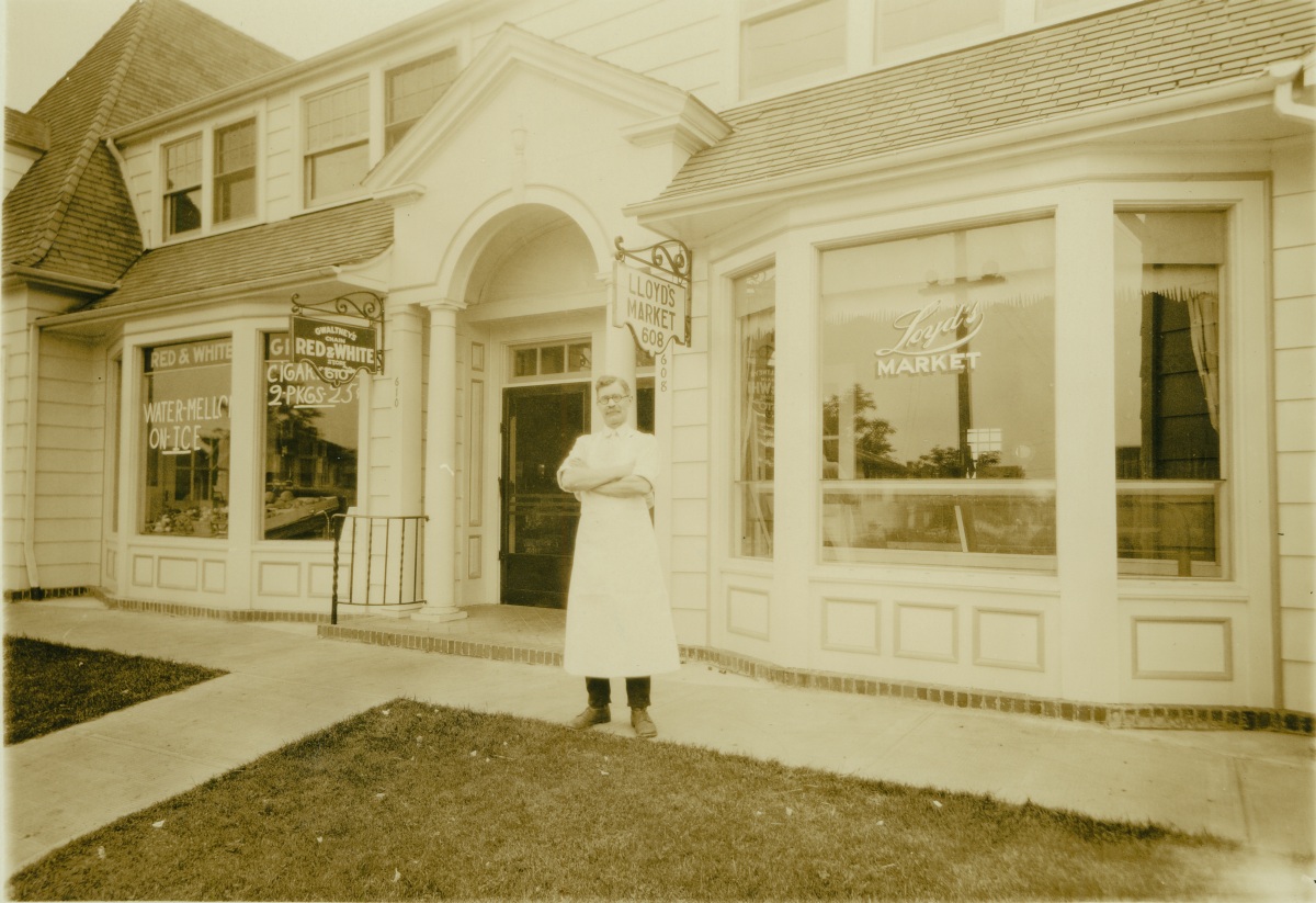
There’s something about the pride of ownership, of hopefulness, of service that comes through in simple portraits of small business owners standing near an open door, their businesses behind them, wares in the window. We loved the recent photo of John Loyd, arms folded, in front of his butcher shop at Killingsworth and NE 15th. We could look at and wonder about pictures like these all day.

Thanks to the City of Portland Archives, we’ve come across a few more—taken on NE Alberta in the early 1930s, between NE 20th and NE 23rd. The photos came to us without any identification—a challenge we love—so we’ve spent some time this week in research mode and revisiting these places trying to piece together the basics of their stories. Each image is worth taking time with. Click in and have a good look around for the details, sense that pride of ownership, look for clues, watch for the reflections in the window. And think about change, which is so clearly evident on ever-changing Alberta.

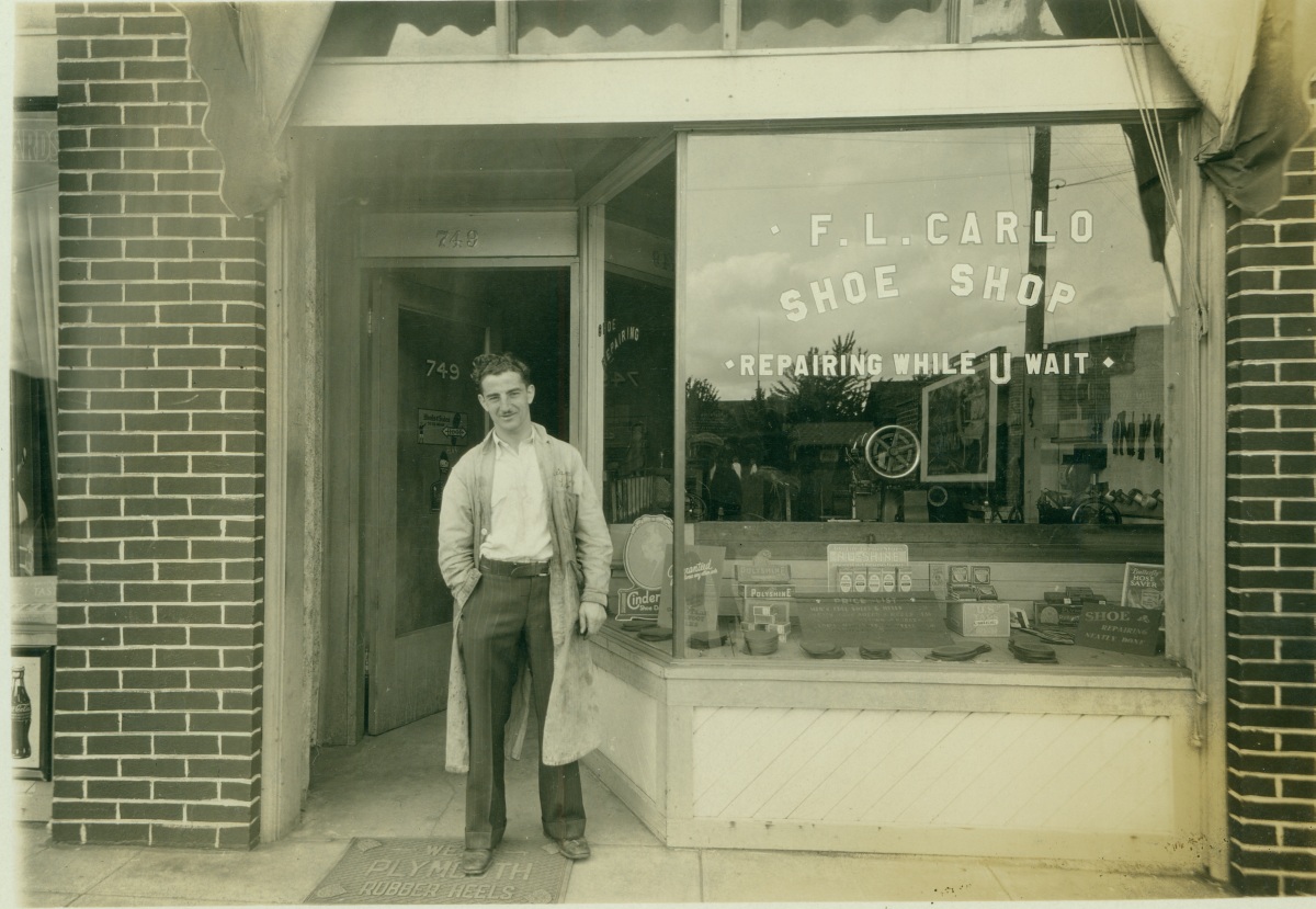
F.L. Carlo Shoe Shop – 1931

Courtesy of City of Portland Archives, image A2008-001.34

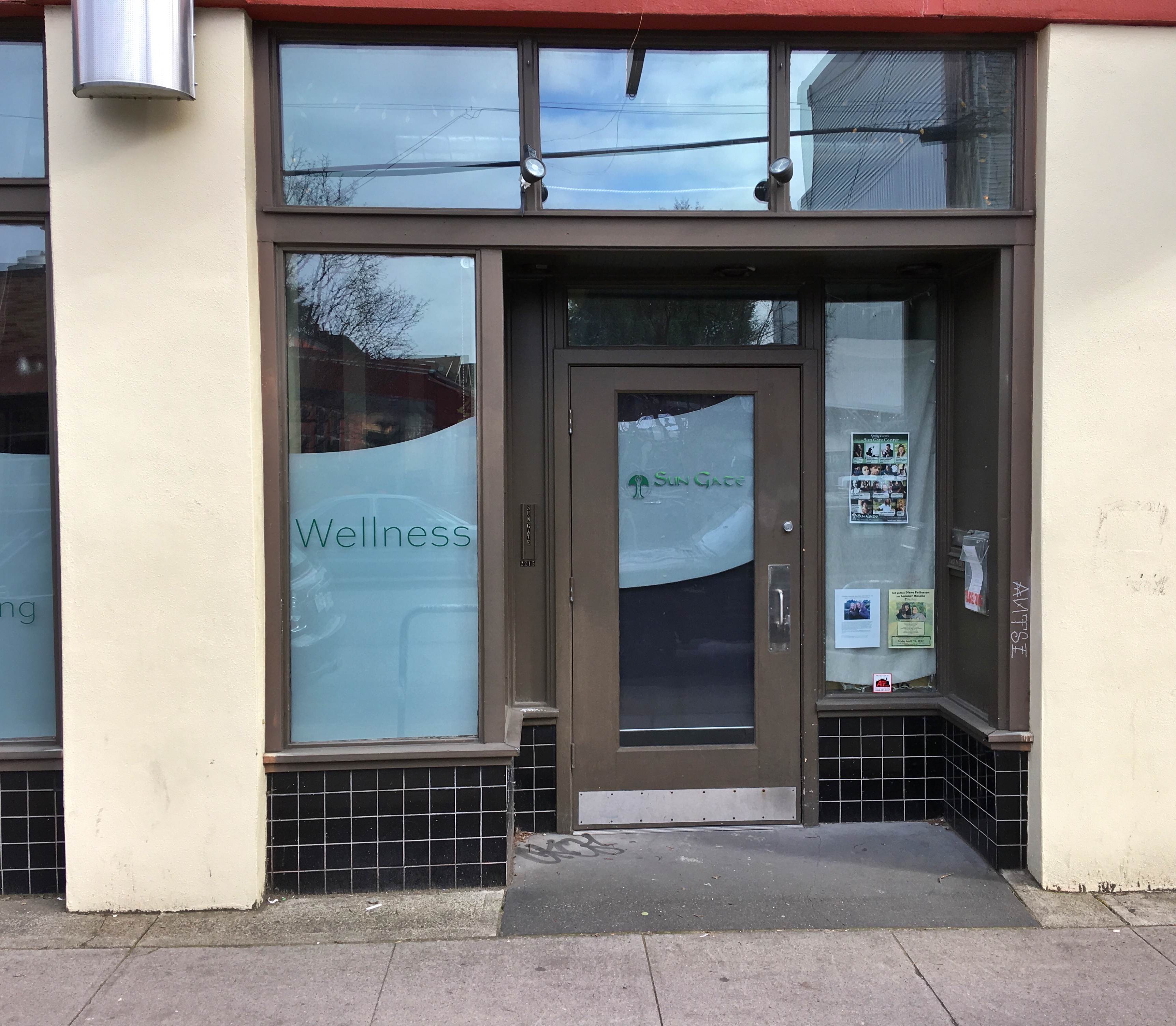
How can you look at this photo and not smile back? The proprietor’s friendly smirk, hand jammed in pocket of pin-striped trousers, carefully organized window tableau of shoe care products, orderly line-up of tools on the wall. I’m bringing my shoes here. This is 749 Alberta, which after Portland’s Great Renumbering became 2215 NE Alberta (north side of the street). While the building is still there, its façade has been reconfigured several times over the years. This is about as close as we think we can come today:

2215 NE Alberta (detail), 2017

Here’s what we learned about our smiling shoe repairman. While the name on the window says Carlo, we believe he is actually Ciarlo, one of a family of Ciarlos who ran shoe repair shops in several Portland neighborhoods during these years. Emilio and Mary Ciarlo and their seven children lived in southwest Portland’s Italian neighborhood. The couple immigrated to the US in 1900 from Serra Pedace, Italy (in the south), and Emilio set up a shoe repair shop downtown near SW 2nd and Madison. Two of his sons (all of the kids were born in Oregon) Giuseppe and Vincent, also had shops in Westmoreland and out on SE Foster.

City directories for the early 1930s list this Alberta address as “Emilio Ciarlo,” but here’s what we think: Emilio helped set up his younger sons here on Alberta as they got their start. We don’t think this is Emilio: in 1930 he was 57 years old, plus his immigration papers indicate he was missing most of his left hand. Our guess is that this is son Louis Ciarlo (age 21 in the 1930 Census), who along with his 19 year-old brother Frank were just starting out in the shoe repair business. Our guess is that “F L Carlo” is likely Frank and Louis Ciarlo. It was not uncommon for immigrants of the day to simplify or “Americanize” their names. In fact, Giuseppe’s shop in Westmoreland was called American Shoe Repair.

The “rest of the story” on this is that their business operated at this address from 1930-1932, but the storefront was vacant after that until the late 1930s. Later city directories show Louis as a driver and Frank as a machinist, though brothers Giuseppe and Vincent stayed with shoe repair throughout their lives.

An unknown in the midst of this and the other two moments in time is the motive and identity of the photographer. Was he walking up the street taking pictures for a small fee? Was he as fascinated as we are in the stories and adventures of the small business owners? Was he thinking about the future? Look carefully in the reflection of the window at Ciarlo’s and you can see the head, cap, white collar and shoulder of our photographer (you can also see a billboard reflected from across the street). Hmm.


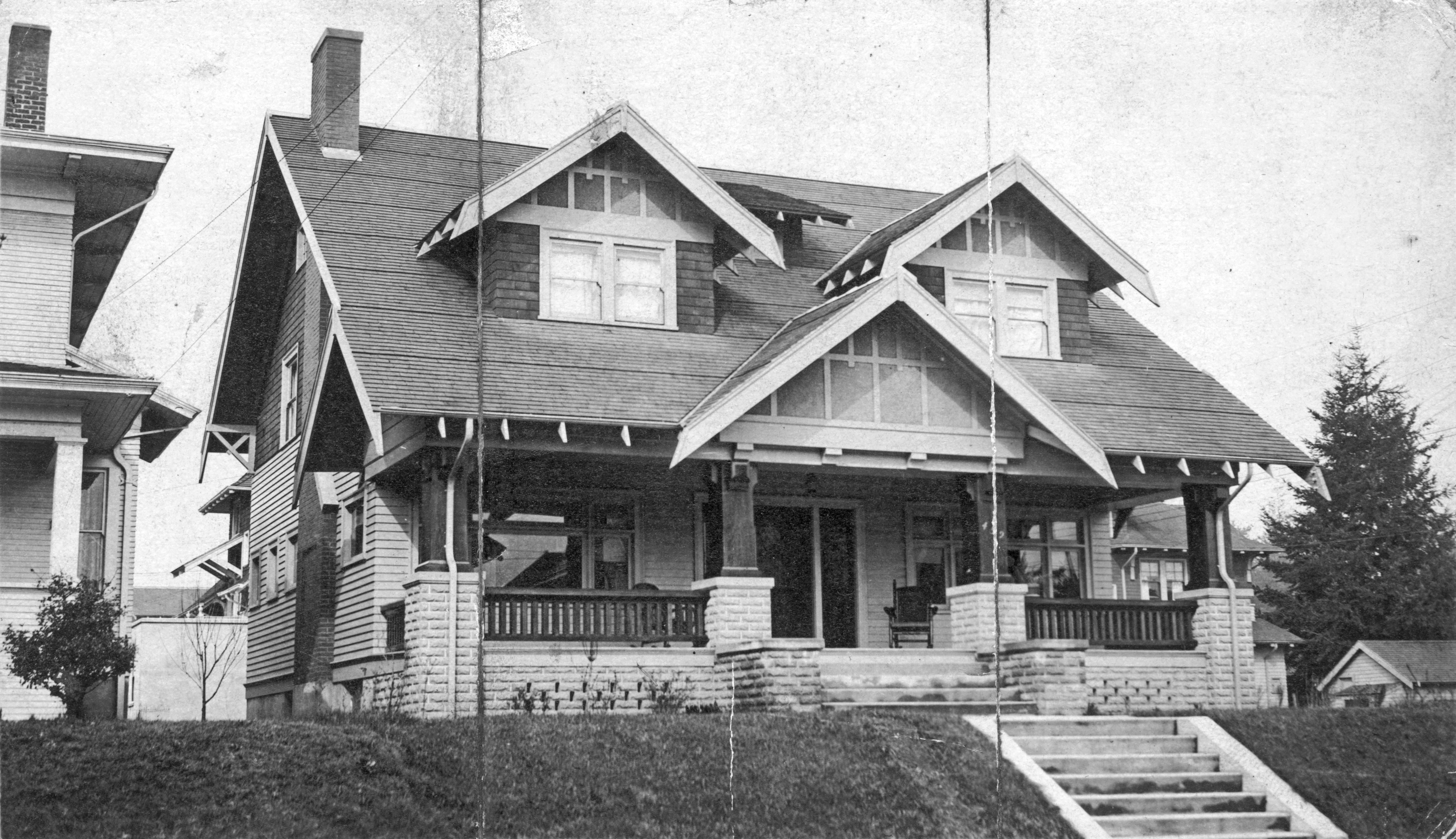
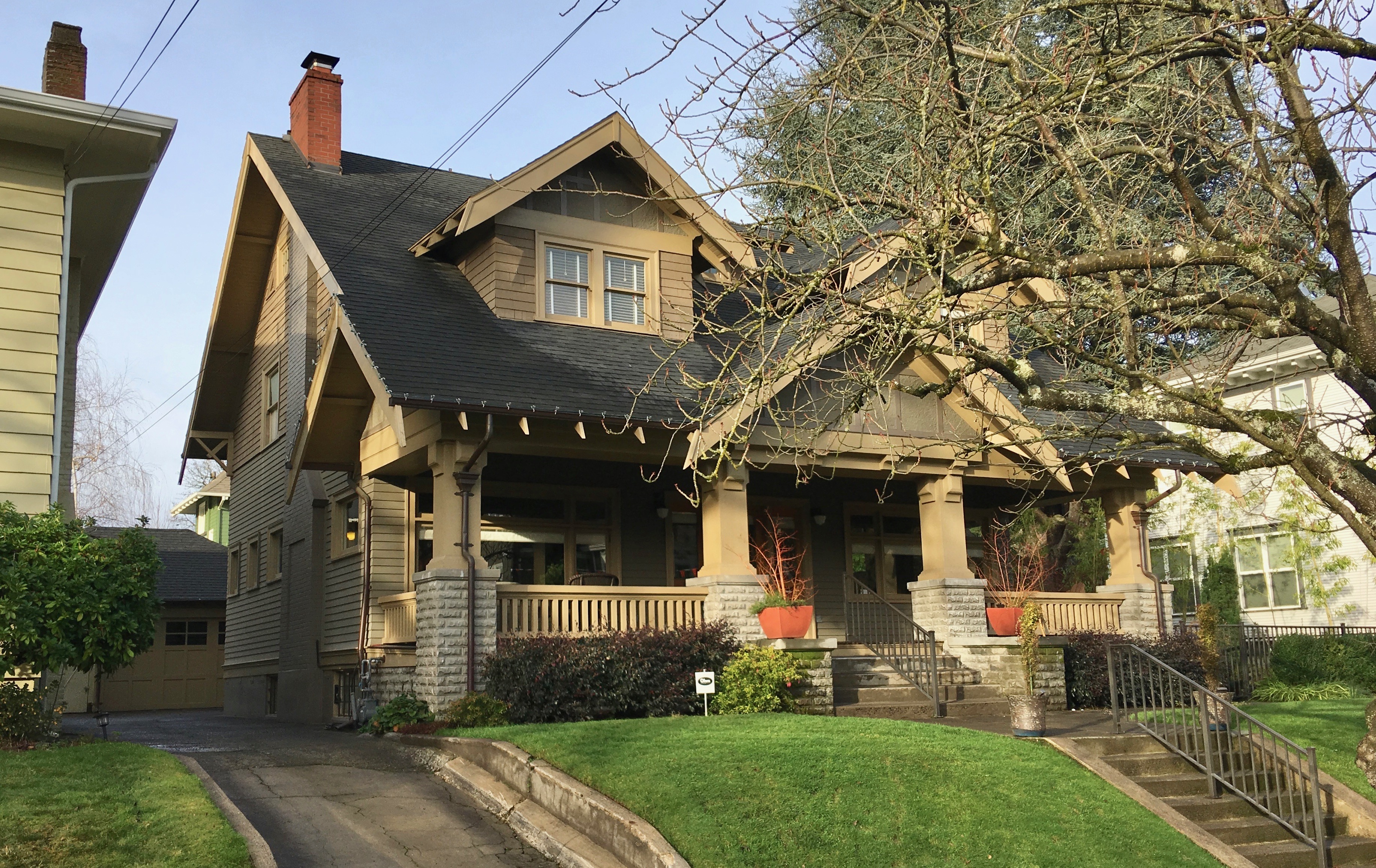
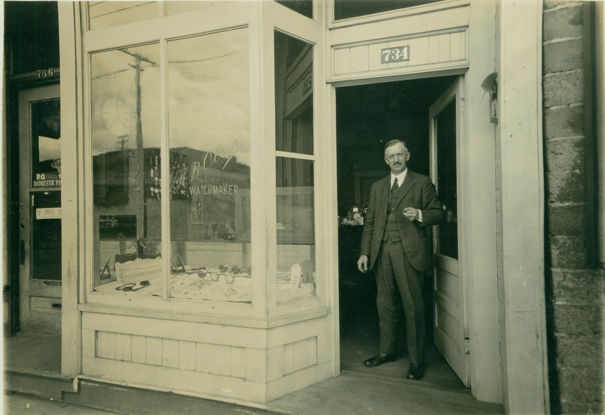
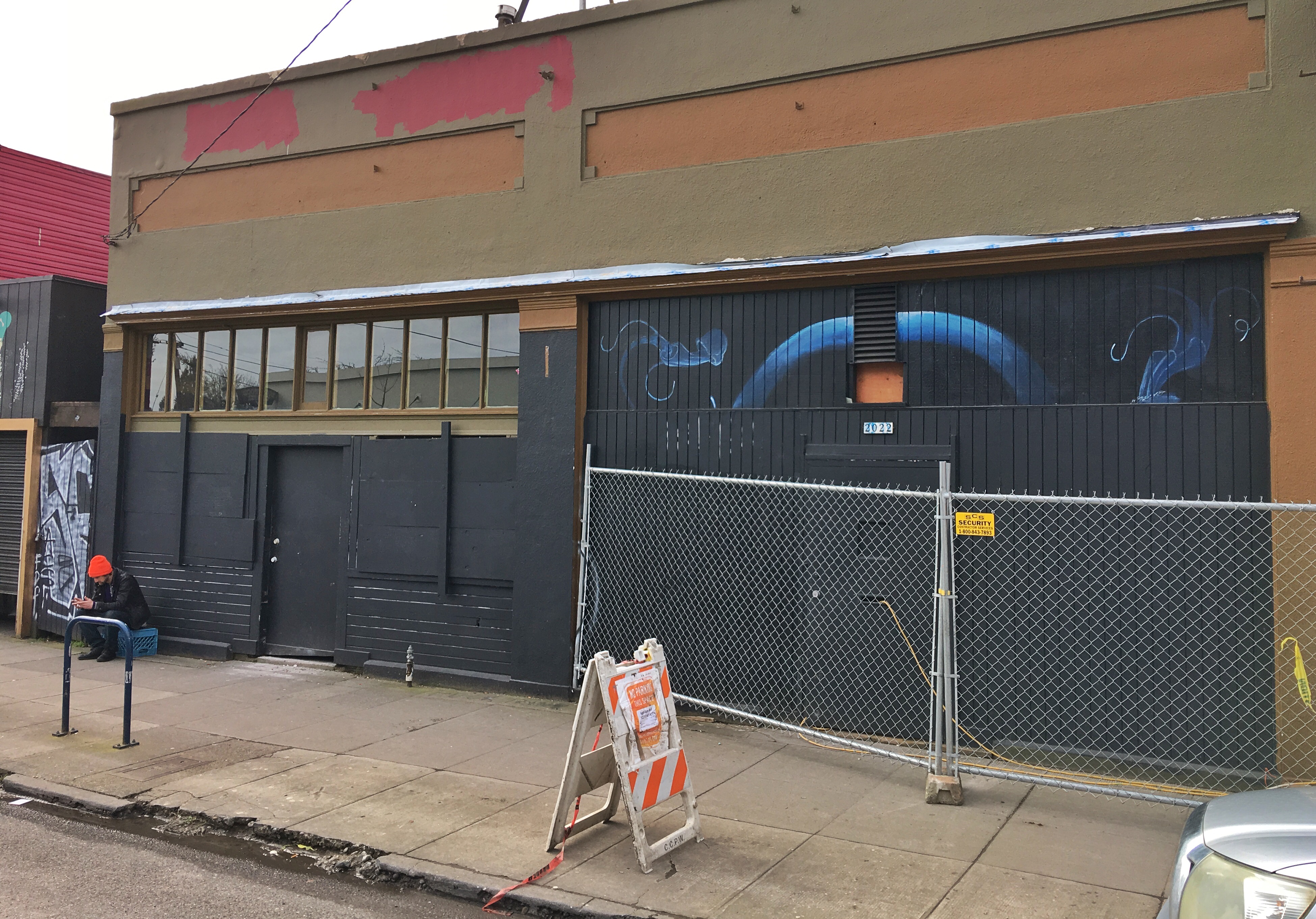
H.B. Olsen, Watchmaker – 1932

Courtesy of City of Portland Archives, image A2008-001.32

One block west and across the street from Ciarlo’s was H.B. Olsen, Watchmaker at 734, which became 2112 NE Alberta. Built in 1908 when Alberta was still a dirt road, this building still stands though it has seen major modifications and better days. A small residence is located at the rear of the shop and on the second floor. It’s just next door to the east from the American Legion Post 134. Here’s the same view today:

2112 NE Alberta, 2017

Halver B. Olsen and his wife Marie immigrated to the US from Norway in 1902 and lived in Minnesota before moving to the Portland area in 1926. When this picture was taken, Marie had recently died and H.B. had moved from the upstairs apartment attached to this business where the two lived into a rented room in a family house just up the block. He was 52 years old in 1930, no children. H.B. ran his watch and jewelry repair at this address until 1935 and then he disappears from the city directories.

The rest of the story on this building is described by another old photograph fanatical researcher like ourselves like this:

It also served as a “restaurant & deli (1916), shoe repair shop where one of owners died of stroke on premises (1917-1922), “store” (1924), coppersmith’s shop (1924), barber shop (1925-26), “Alberta Food Lockers” (1948), “Bud’s Plumbing Co. (1956), upholstery shop (1983). The property was for sale and vacant for several longish intervals during 1960-64. It had a 2 BR, 2BA apt. upstairs.”

That excerpt, by the way, is taken from comments posted on an outstanding blog we follow and recommend called Vintage Portland, which is run by the City of Portland Archives and Record Center and regularly features old photos drawn from the city’s collection. This one appeared there in November 2013.


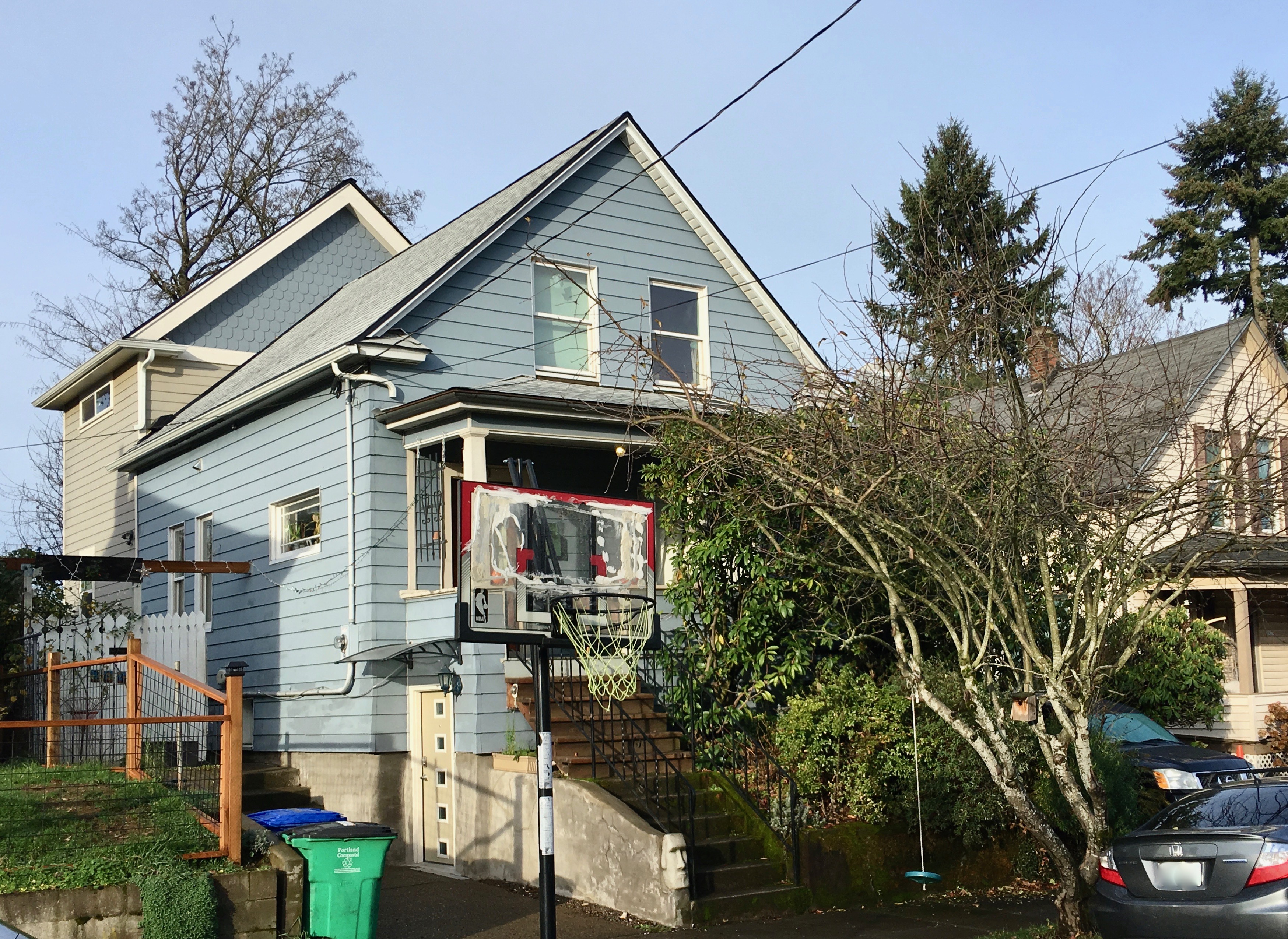
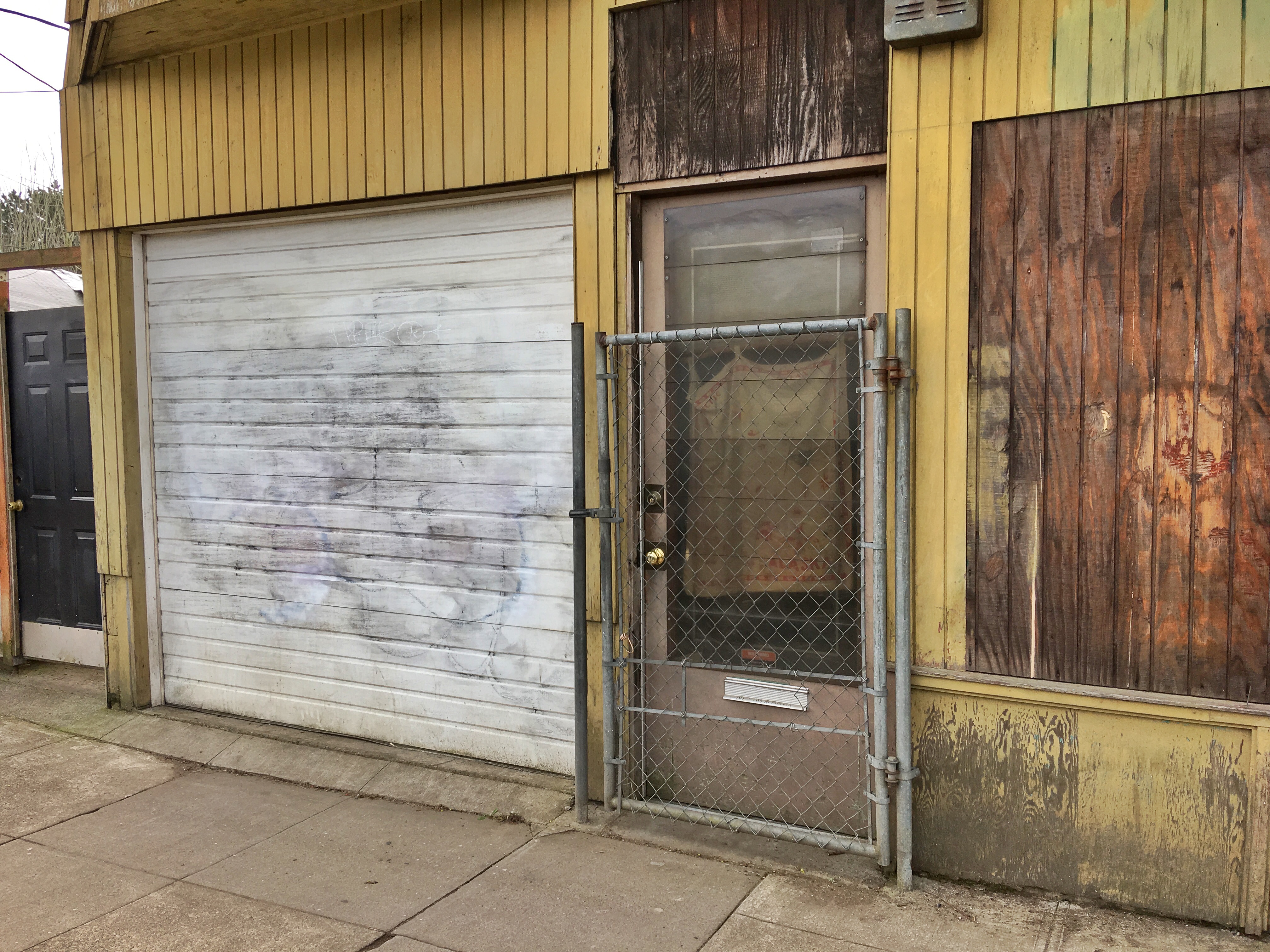
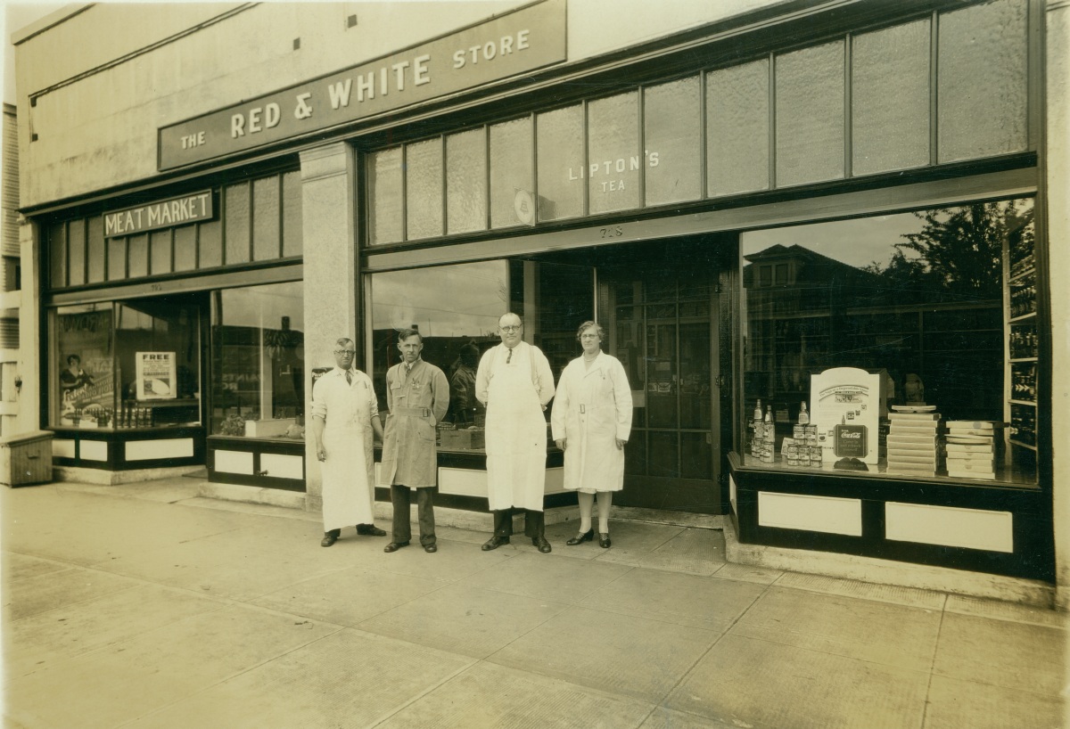
Irving Market and Grocery – 1932

Courtesy of City of Portland Archives, image A2008-001.31

Of all three photographs here, this building façade is closest to its original shape, at least for the moment. When we dropped by recently, construction was underway. Whenever we see chain link fence out in front of an old building, we get nervous.

2022 NE Alberta, 2017

This original old photo came with little identification, simply the “Red and White Store, 718 Alberta.” We’ve determined it was actually known as the Irving Market and Grocery during its short life, operated by David and May Irving, who we suspect are the couple to the right. His military records—he was a WW I soldier—indicate he was six feet tall. David was born in Canada and May was from England. Did they meet during the war? In the 1920s, they ran several small grocery businesses in Portland. The couple owned a home not too far away in Rose City Park.

We’ll remember from our recent post about Gwaltney’s Red and White Store on Killingsworth that these independently owned stores were everywhere. The Red and White franchise enabled Mom and Pop businesses like the Irvings to set up shop by buying Red and White branded merchandise, marketing materials and even store shelving. In the mid 1930s, there were 6,700 Red and White markets nationally. We had several in the neighborhood.

This building on Alberta was vacant in 1930 before David and May were on the scene, and the Irving Market and Grocery’s life was short: by 1933, the building was vacant again and remained so until 1937 when the Ray-o-Sun Grocery moved in, and David had gone to work for a large wholesale grocery company.

The subject of small neighborhood grocery stores, as AH readers will know, is close to our heart. We’ve taken an interest in understanding the life stories of local Mom and Pop grocery stores in the neighborhood. Understanding the ecosystem of small grocery businesses at the time also points to how shopping trends, the larger economy and day-to-day life in the neighborhood have changed over the years.

In 1930, we count 208 businesses along Alberta between MLK and NE 33rd Avenue. We’ve gone back through city directories of the late 1920s and early 1930s and have found a vacancy rate for any one year between 15-20 percent, highest in the early 1930s.

An analysis like this also turns up some interesting trends. Here’s a listing of the types of businesses on Alberta in the early 1930s, in descending order by type: 15 grocery stores; nine beauty shops or barbers; seven shoe repair shops; seven tailors or sewing shops; four butchers; four bakers; four pharmacies; four filling stations; four variety stores; four sweet shops; three hardware shops; three auto repair garages; three dentists; three furniture stores; two doctors; two theaters (including the Alameda Theater, which we’ve written about here on the blog); two radio shops; two restaurants; one ice delivery station; and a hodge podge of single shop fronts for plumbers, electricians, painters, real estate agents, sign shops, pool halls, watchmakers (our Halver B. Olsen), hat shop and others, including quite a few residences. And a busy streetcar line connected these businesses with local residences and beyond.

There’s some perspective for you. Radio, ice, hardware?

Time travel at 15th and Killingsworth

We came across a great old photo recently of a proud apron-clad businessman standing, arms crossed, in front of his market at the corner of NE 15th and Killingsworth. It’s a photo worth having a look at. We’ve been staring at it for a while to puzzle through some of its riddles.

Photo courtesy of Portland City Archives, image A2008-001.39

First, there is no identification. Who is this proud man? Second, there’s a spelling conflict: is it Loyd’s (as the window suggests) or Lloyd’s (as the shingle suggests), and how did that happen? What did Loyd’s sell? And when you really look at the picture you understand it’s actually two businesses: Gwaltney’s Red and White Market where the watermelons and cigarettes are for sale, and Loyd’s (or Lloyd’s, depending on which sign you read). Can you hear the spring in the screen door when it opens, and the door smacking back into the frame as it closes?

We do know where it is: the southwest corner of Killingsworth and 15th. Loyd’s was 608 and Gwaltney’s was 610. After some research, it became clear to us that the main entrance to Gwaltney’s was off the picture to the left, at the corner. More on that in a moment. These addresses translate to 1478 Killingsworth today. Remember, all of Portland was readdressed in 1931, so we know this photo was taken before that. We’re guessing 1929-1930. Built in 1927, the building still stands. A look back through permit history shows many chapters and changes: market, pharmacy, restaurant, tavern, pool hall, rented rooms upstairs, and now office space.

Here’s a look at that same view today. The portico is gone, the front of the building looks like it has been pushed out a bit, the grass is gone and Killingsworth has been widened, putting the early vantage point almost into the street. See for yourself:

1478 NE Killingsworth, March 2017

Next is the question of who this gentleman is. We believe this is actually Mr. Loyd in front of his store, not Mr. Gwaltney (who would have been posing in front of his own front door somewhere off the picture to the left). With the help of the Polk City Directories, census records and a few other genealogy tools, we believe this man is John F. Loyd (only one “L”). From 1929-1939 he ran a meat market at this address. For some of those years his son Clarence helped out in the shop. Loyd lived on Dupont Street near the Broadway Bridge (now gone under the Portland Public Schools building–Dupont no longer exists) with his wife Alma and children Clarence, Ruby and Lester. He was a WW1 veteran. John and Alma were born in Sweden and immigrated to the US in 1900.

Willis H. Gwaltney was the shopkeeper at the Red and White Store, off to the left. Gwaltney and his wife Martha lived just around the corner on NE 16th. He spent a career in the grocery business, his last assignment being at the Kienows on SE 39th and Lincoln. In the 1930s, Red and White markets were everywhere. Each was independently owned: shopkeepers could buy Red and White branded merchandise, marketing materials and even store shelving. In the mid 1930s, there were 6,700 Red and White markets nationally. We had several in the neighborhood…more on that in a future post. Gwaltney’s shows up in the Polk City Directory at this address from 1929-1933, when Willis moved on, likely a victim of the changing economy.

While out taking pictures of this building, which in 2017 is the home of Portland/East Metro Habitat for Humanity, we decided to knock on the door and share this picture with the current occupants. The very friendly Tim, who was at the front desk there, was welcoming and excited to see Mr. Loyd. Tim wanted to share an old picture of his own and took us into the back room to see a large format framed photo of the building hanging on the wall, shown below. The timeframe for this one is a bit later.

The Oakhurst Pharmacy is listed in city directories from 1940-1948, and if you look at the passerby’s hat, the ads in the window, the style of street sign, that timeframe fits. Gwaltney’s is gone. Lloyds is gone and the “welcome to my front door” sense of entering the building on that side has changed, Mr. Loyd’s proud perch now covered up with an awning and boxes. The street has been widened and grass replaced with concrete. Looks like they must have had a leaky roof too, the valley of that far gable reinforced with flashing. Here it is:

1478 NE Killingsworth, about 1945. Photo courtesy of Habitat for Humanity Portland/East Metro

March 2017

Oakhurst, by the way, is the name of the platted addition just west of the Vernon area between Killingsworth and Ainsworth from 14th to 19th, originally platted in 1892. We’re betting that name has faded away like so many of Portland’s other plats. Have you ever heard someone talking about Oakhurst? We haven’t.

Back then, Lee Witty was proprietor of the Oakhurst Pharmacy and he must have been a resilient person: the pharmacy appears multiple times in The Oregonian during his eight years in stories about several armed robberies, a fire that damaged part of the building, and even a major accident in March 1947. Check it out:

From The Oregonian, March 10, 1947

How much longer will this building last? Good question. It has certainly seen its share of change. Uncovering its story, like all the research we do, is about as close to time travel as we can get.