Vernon Tanks: Water arrives, but more storage capacity needed

We’ve been thinking these days about the history of the big green giants that anchor the block at NE 19th and Prescott. In our last post we learned about the “Vernon Standpipe” as it was called, and the challenge in the 19-teens of keeping it filled with enough water to supply the neighborhood that grew up around it. That is, until this tank came along almost exactly 100 years ago.

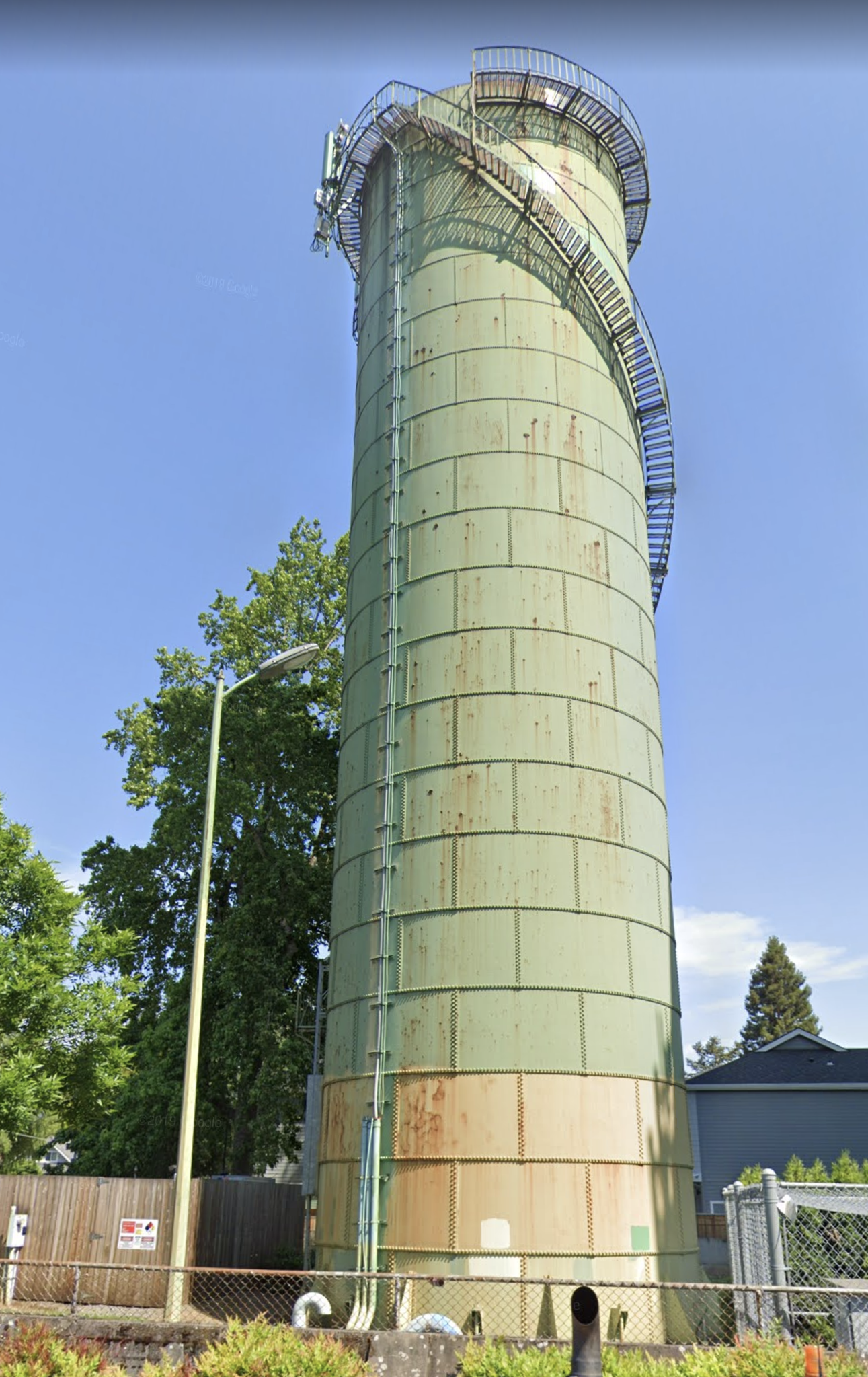
The senior of the two tanks at NE 19th and Prescott, constructed in the fall and winter of 1920-1921 for $100,000 by the Chicago Bridge and Iron Company, holding 1 million gallons. Photographed April 21, 2020.


In our first installment, we left our expectant City Commissioners at the corner of NE 57th and Fremont with a shovel in their hands ready to dig a 14,280-foot long trench for a big new pipeline that would push more water from the Mt. Tabor reservoirs into our thirsty neighborhoods.

From The Daily Oregon Journal, August 8, 1915. This wooded street scene is likely somewhere along NE Skidmore before the residential neighborhood we know today had taken shape.


The pipeline dig began on April 16, 1915 powered by 59 unemployed men hired from the city’s standing civil service list. By May, workers at both ends of the project were working toward each other. Promises had been made to alleviate the water shortage by summer, so momentum was important and the newspapers took note.

From The Oregonian, May 16, 1915. Interesting to note that the picture in the lower right shows the intersection of NE 24th and Skidmore, the spot where this water main broke in March 2019 flooding homes and local businesses.


By July 1915, crews had met in the middle and the golden spike moment seemed close at hand:

From The Oregonian, July 20, 1915.

These were the headlines everyone wanted to see and even though the big pipeline job was done, Water Board engineers knew volume and supply were only part of the equation. The hand-me-down Vernon Standpipe just didn’t have sufficient storage capacity to keep up with the growing need here and on the Peninsula. But the new main bought time for more thinking and engineering.

Water officials must have been relieved that the most pressing problem over the next few years seemed to be finding someone to paint the 100-foot-tall, 25-foot-diameter Vernon Standpipe, expressed in this September 19, 1917 headline: LOFTY PAINTING JOB GOES BEGGING. No bidders, so the standpipe’s bare panels became its trademark.

By August 1920, the city announced plans for construction of a new 1 million gallon storage tank for the site that would replace the 350,000 gallon Vernon Standpipe. And fortunately for us, a city photographer documented the progress, which went like this (double click into any of these for a closer look…there’s lots to see):

By late summer 1920, workers were busy on the plumbing for the new tank and establishing a concrete foundation that would support the tower and the million-gallon tank above. The water alone weighed 8.3 million pounds. This view is looking north from the tank site; the houses are on the north side of Prescott.


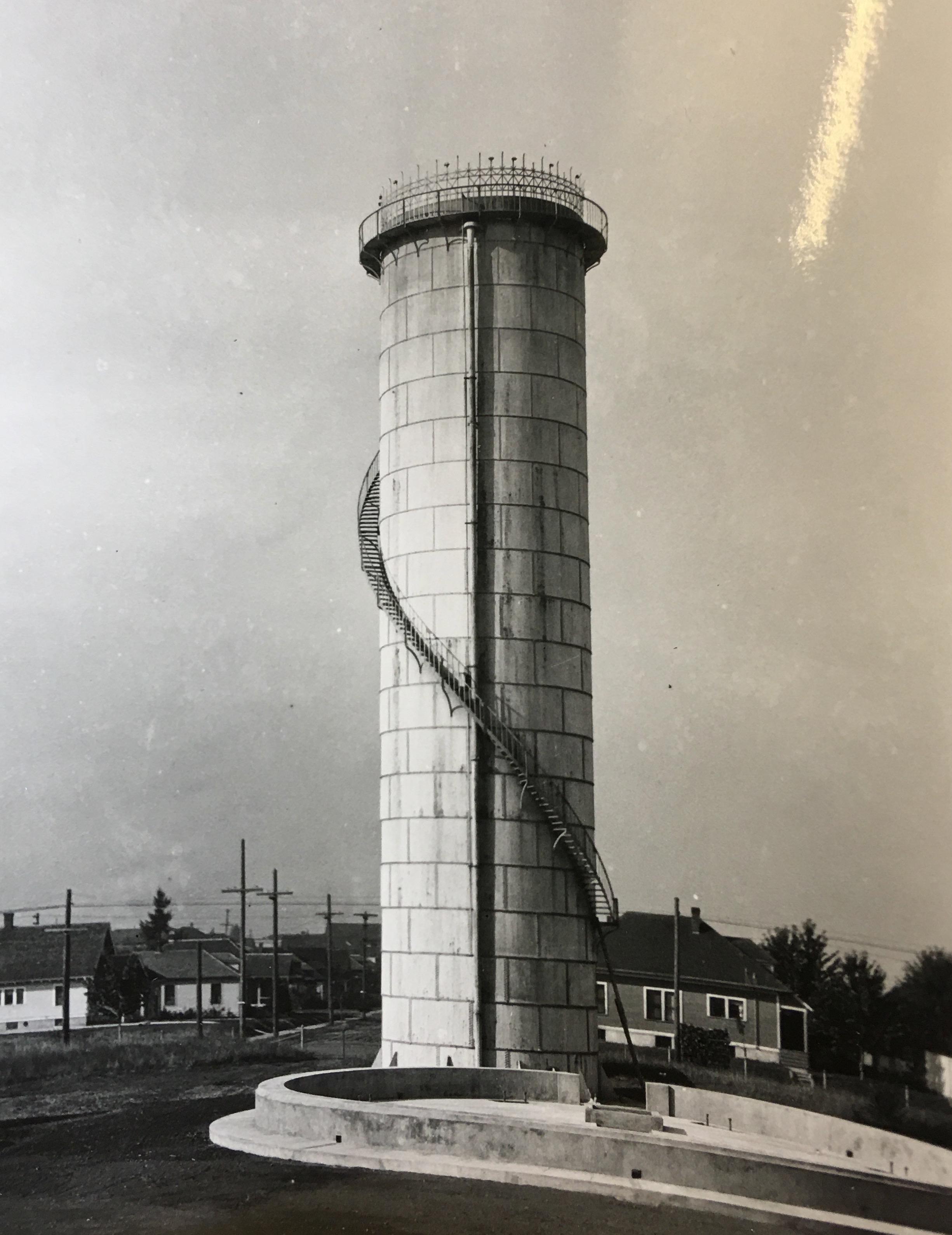
By the fall of 1920, the round base had been poured (foreground) and was ready for tower construction. This view is looking north showing the standpipe behind (nice stairway and railing, eh?), and the T intersection of NE 19th and Prescott.


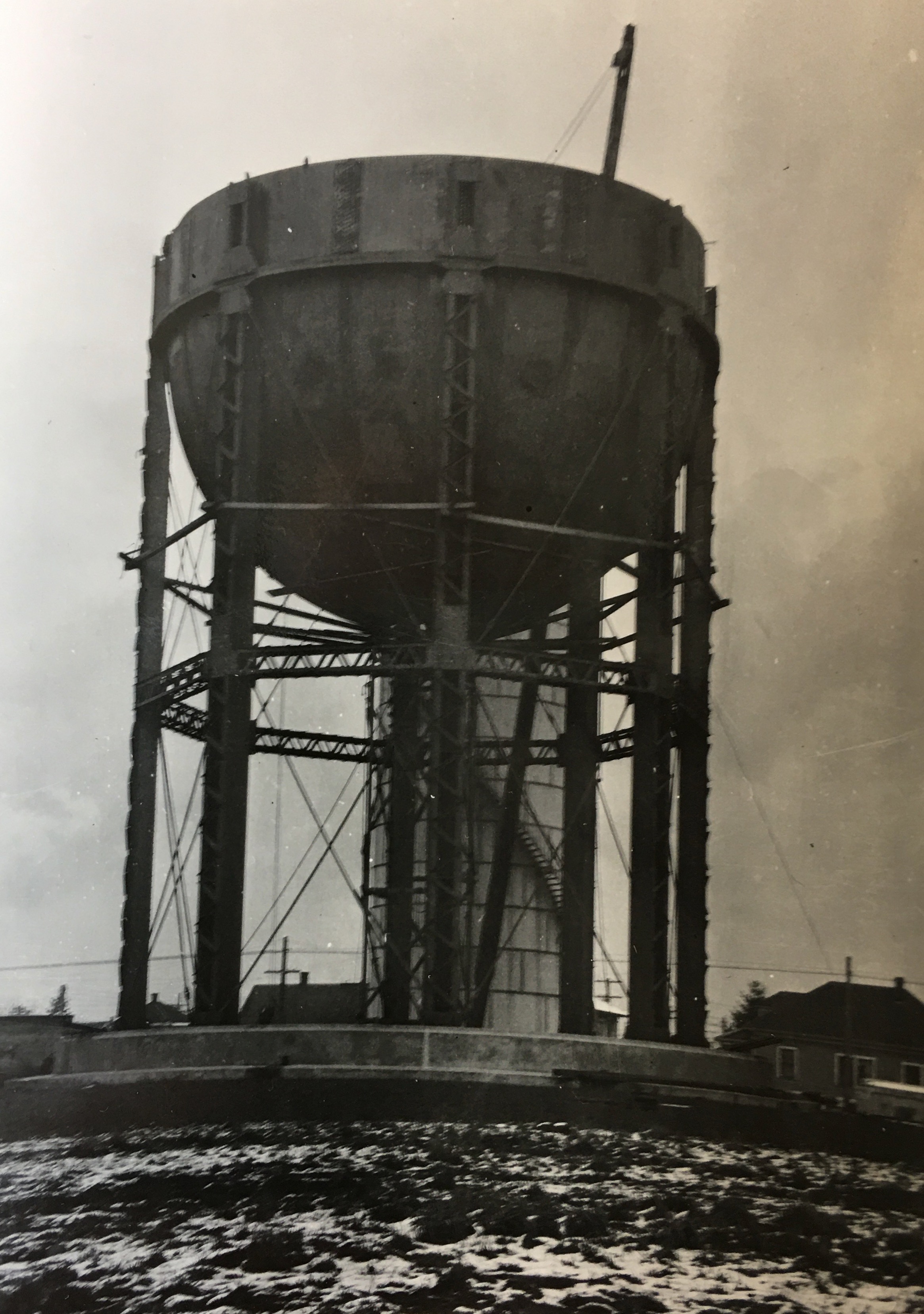
By late 1920 or early 1921 the new tower and tank are taking shape. This view looks north with the standpipe behind and snow on the ground.


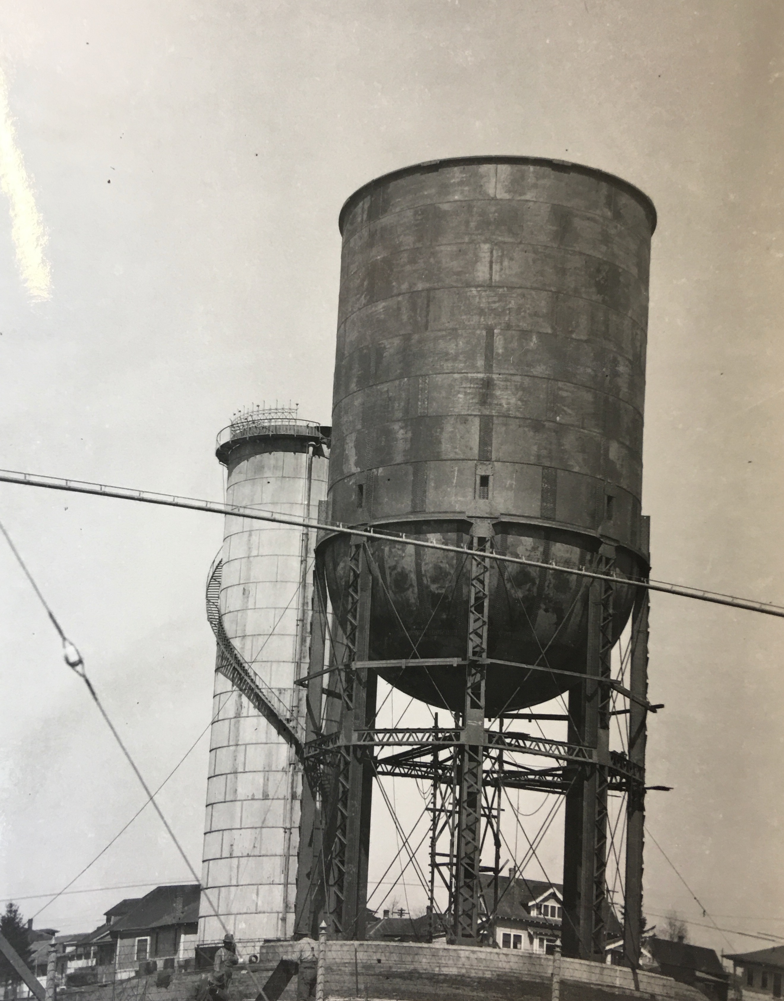
In this view looking north in early summer of 1921, workers are in their shirtsleeves and the tank is done.


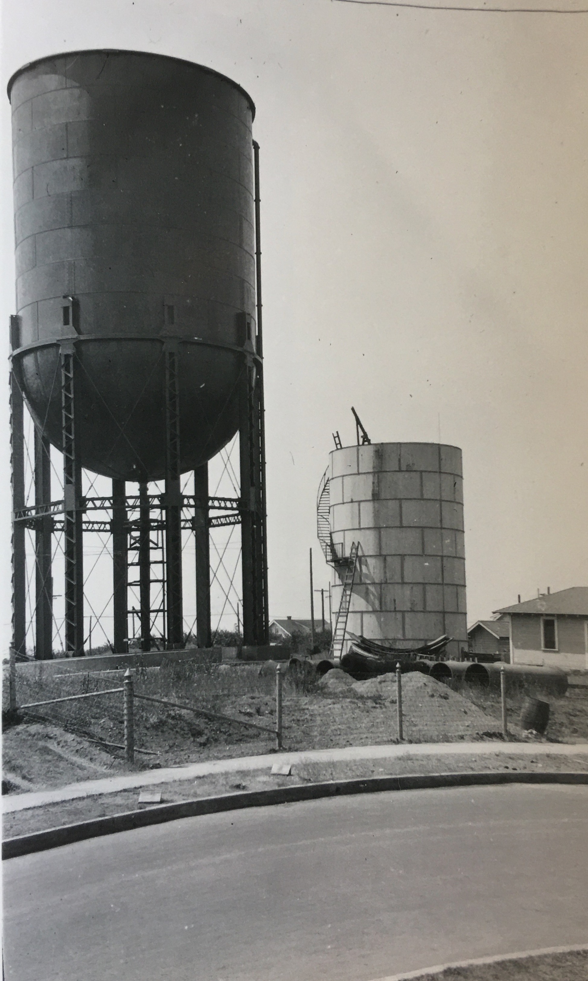
In August 1921 the city paid Portland-based Le Doux and Le Doux Construction $10,477 to dismantle the former Vernon Standpipe (underway in this photo) now that the new tank was in place, and to relocate the pipe to a new venue in St. Johns at the corner of N. Princeton Street and N. Oswego  Avenue, where it stands to this day (below), still in service at more than 120 years old:


Next up: The 1920 tank is eventually dwarfed by the biggest tank in the nation.

Vernon Tanks: Landmarks hidden in plain sight

The thing about the Vernon tanks is that we see them so often they’ve somehow slipped from view.

Like wallpaper, we take their faded green bulk for granted. But when we pay attention, they loom large, visible from all corners of the neighborhood. Even arriving by air into the Portland area—remember flying on airplanes?—the tanks jump up out of the grid to announce the presence of the Vernon-Sabin-Alameda neighborhood, the start of the Alameda Ridge.

What if we looked at them in a new way with fresh eyes? Can you do that?

The Vernon Tanks, NE 19th and Prescott, April 21, 2020

The story of these tanks is a neighborhood story about water. A lot of water. Because it involves so much water and so much time, we should break it into a few parts:

In this first part we’ll describe the early days of Portland’s amazing water system and how it arrived in our neighborhood.

In the second part, we’ll describe the pivotal role this area played as a kind of water waypoint: how the city was able to get a lot more water here where it could pause for a bit before being moved farther out the line to other thirsty neighborhoods.

In the third part, we’ll focus on the water tank building effort that produced the green behemoth we know today.

In a post-script, we’ll have a look at a great photo from the big day the guys poured concrete in 1920.

To help tell these stories, we’ll share a bunch of 100-year-old photos that haven’t seen the light of day for decades, some 50-year-old negatives that don’t even have prints for them, and lots of news clippings that help us piece it all together. So, grab a glass of water and let’s go.


Watering the Grid

Fortunately for all of us in Portland, water runs downhill. Our abundant clean water starts in Bull Run on the forested slopes of Mt. Hood and through an engineering miracle beyond your wildest imagination courses through pipes and headgates, valves and meters all the way to your kitchen.

Back at the turn of the last century as eastside neighborhoods were just taking off, one of the many challenges of carving out the grid of streets had to do with getting city services in here. We’ve already written about the sewer system, which was available to most of our homes by 1914. But water was first.

Here’s a look at the neighborhood in 1909, thanks to Sanborn Fire Insurance maps. It’s an index of the many individual map pages (each big black number represents a more detailed map). Double click for a closer look.


Note the city limits boundary just east of NE 33rd. Also note the open fields that were soon to be filled in by Alameda and Beaumont. When this map was drawn, this part of our city had been Portland for less than 20 years. Imagine the biggest subdivision you’ve ever seen rolling off east through the fields to the horizon.

Look carefully at the corner of NE 19th and Prescott (we’ve circled it in red). That’s the Vernon Standpipe, the earliest predecessor of the tanks standing there today, built and plumbed in 1906. Here’s what the Vernon Standpipe looked like in August 1920, courtesy of City of Portland Archives, A2008-009.

Looking southwest from Prescott and NE 20th.

A standpipe is basically a fancy name for a tank that is taller than it is wide and is used to create pressure down the line in the system, which is exactly what the neighborhood needed in its earliest days. Think of it as a miniature above-ground version of the Mt. Tabor Reservoirs, where water could be stored waiting for you to turn on your tap.

Water in the standpipe came from Mt. Tabor in an elaborate system of pipes. The problem was—as the grid spread out and more houses were built—the pipes were too small to carry enough water, the standpipe wasn’t big enough and couldn’t exert enough pressure, and people were running out of water.

That first standpipe was installed at NE 19th and Prescott because of its elevation on the ridge. It used to stand at the corner of NE 13th and Schuyler, but was shifted uphill in 1906 (at a cost of about $10,000) to get the extra pressure. Interestingly, it took the city nine more years to eventually sell the empty 100 x 100 lot on Schuyler for $4,500 after neighbors complained it had become an unsightly dumping ground.

By 1910, water engineers knew they needed to increase capacity to north and northeast Portland and by 1912 the Water Board had acquired adjacent property at 19th and Prescott for a more elaborate storage facility.

A water crisis in July 1914 created political pressure: the standpipe went dry when all the new homeowners in the area decided to water their new lawns at the same time (seriously). On July 14, 1914, a rationing program was put in place allowing odd-numbered houses to use the hose on odd-numbered dates and even-numbered houses on even-numbered dates. Neighbors glared at offending neighbors. Tickets were written. And the Water Board quickly reminded an unhappy public that no cut in water rates was planned even though homeowners were rationing.

The hubbub of the July water crisis focused public attention on water and led to reporting on plans already underway by the Water Board. From The Oregonian on July 21, 1914:

“At present, the 30-inch trunk main for the district extends only one mile from the [Mt. Tabor] reservoirs. It is proposed to extend this to the Vernon standpipe, a distance of two and one-half miles, so that the supply at that point will be more than ample even on the hottest days.”

By September 1914, the city had completed plans to extend a much larger 30-inch water main from the intersection of NE 57th and Fremont north to Skidmore and then straight west all the way to the Vernon Standpipe, a distance of 14,280 feet. The job would cost $113,000.

Months before the work would even begin (and in light of consternation about running dry and rationing), city commissioners were celebrating what this would mean: “This will treble our capacity,” said Commissioner Will Daly. “We expect to have the new work completed by next summer. As all the property in this locality is unplatted, we do not expect difficulty in obtaining the rights of way.”

Open fields and a straight shot down Skidmore all the way to the Standpipe.

Next up: More water arrives, but limited storage capacity creates problems.

Home History School | Old School

A young person we know told us recently that it felt funny to say this, but he actually wouldn’t mind being being back to school. This made us smile. Schools contain so much of our lives and our memories. Friends, teachers, the playground, your classroom. The smell of the hallways, the cafeteria, the auditorium.

So this week we’re turning back the clock on a few nearby schools and the neighborhoods that surround them.

Old Vernon School, Art Classroom, about 1915.

These buildings are like time travelers that have seen change all around them: generations of kids who’ve grown up in the hallways; houses springing up here and there; school buildings themselves changing (or, like Kennedy School, closing down altogether).

This week’s activities ask you to explore places you might think you already know everything about–the immediate vicinity of nearby schools– to see and think about change. Click below for the latest installment.

Old School


Home History School | Find your streetcar

Northeast Portland streets were once alive with streetcars taking neighbors to work, school and play. They were an institution that connected us with the city and with our neighbors. Noisy, drafty, cold in winters but alive with neighbors going places, these electric-powered vehicles were loved by Portlanders, and our system was the envy of the country.

The Beaumont streetcar at the end of the line between Klickitat and Siskiyou on NE 41st Avenue, about 1914. Courtesy City of Portland Archives.

The rise of cars and buses in the 1940s brought an end to streetcars, but if you know where to look, you can still find clues, and there’s lots of photos, memories, maps and even old film to teach us about these times. This week’s activities get you looking for clues, finding your nearest streetcar route and learning about the electric trains that criss-crossed Northeast Portland neighborhoods.

Click below for this week’s installment.

Find Your Streetcar

Anderson’s on Alberta | Post Script

We’ve enjoyed hearing your thoughts about the great Anderson’s Grocery photo from a couple days back: memories of Green River Phosphate sodas; recollections of other Anderson’s stores, speculations on what else might be in the back out of view from the front window. We even heard from the folks at Grasshopper who occupy the store today.

Check out this original work sent to us by photo wiz and fellow history friend Brian Rooney showing Jim Frost and his crew lingering at the doorway today. Nice Brian.


And a bit of original research by long-time AH friend John Hamnett who found this estate sale advertisement for the leftover stores from the Anderson empire after Carl’s death in July 1940. We think that’s how Jim Frost eventually got situated into his store at NE 30th and Killingsworth:

From The Oregonian, January 21, 1941


Always in search of more context, we looked up Carl G. Anderson’s obituary for you. He died at home on Thursday, July 18, 1940.

From The Oregonian, July 24, 1940

And kudos to our sister Bonnie Hull for inventorying the vegetables (most of which never made it to our table growing up). From left to right on display: zucchini, celery, fennel root, turnips, chard, a squash, peppers, Brussels sprouts, garlic hanging in the window, canned clams in the background and sooo much pancake flour!

Be sure to check out the reflection in the window, too. Look carefully and you can see the overhead lines that powered the Alberta Streetcar. There’s always more to see.


More Time Travel on Alberta Street

It’s time for another Alberta Street merchant portrait to add to the growing collection. Meet the crew from Anderson’s Grocery Store Number 5 at 676 Alberta Street, about 1930. That’s 1816 NE Alberta today (thanks to the Great Renumbering). Sent by AH photo friend Norm Gholston, this one is definitely worth a close look so click in for a good look around.

Here’s a challenge: Think you can identify all of the produce on display?

Anderson’s Store, 676 Alberta Street, about 1930. Courtesy of Norm Gholston.

1816 NE Alberta Street, April 2020

At its peak, Anderson’s Grocery was a 39-store chain of “cash stores” (all on Portland’s eastside) built by Carl G. Anderson starting in 1905, so called because there was no book of credit kept; business was “cash on the counter” only. This particular store was Anderson’s fifth and was well established by the time this photo was taken in the early 1930s. On the back of this photo are cryptic notes explaining that the young man in the middle was the person managing the store: James Franklin Frost.

Jim Frost was born in Selma, Oregon in 1905, married Emma Doering from Saskatchewan in 1927, worked for Anderson’s in the 1930s, enlisted in the service in 1943 and returned from the war to run Frost’s Grocery on the southeast corner of NE 30th and Killingsworth. He and Emma lived within walking distance of Anderson’s, and they ran small neighborhood mom and pop grocery stores all their lives.

We’re still working on the identity of the other two gentlemen—the butcher on the left and Frost’s stock clerk partner on the right. All of them in shirts and ties and shiny shoes, how about that?

Grocer Carl Anderson was a bit of an empire builder, and definitely thought of himself that way. This business profile, written not long after the photograph was taken, provides further insight into Anderson’s humble beginnings and rise to grocery stardom.

From The Oregonian, May 4, 1935

In the year after this story, Anderson opened a grocery in a new building at the heart of the Beaumont business district which we know today as Beaumont Market.

For the record, there was also an Anderson’s Grocery at NE 15th and Fremont, but that’s a different Anderson and a story for another day…

Home History School | History Detective

When was the last time you had a really good look at the clues from your house’s history? Cooped up with a little extra time on their hands, some AH readers have shared clues they’ve been wondering about, like this one. What the heck is that?

It’s an old central vacuum port, which was an amazing modern luxury when it was installed back in the 19-teens. Central systems, powered by an electric motor in the basement, began to appear by 1910 and by 1915-1920 were fairly common.

To indulge your curiosity and powers of observation–and with a little extra time on your hands to look around–enlist the support of your young historians in this week’s suggestions of things to think about and do. Click in below for this week’s installment:

History Detective: What’s Your Story?


Home History School |Active learning about local history

Maybe you have some young people in your world these days looking for things to do to feed their curiosities and continue their learning close to home. As in very close to home. The great pandemic of 2020 has turned our lives upside down in so many ways, and it’s brought your kids’ classroom to your dining room table.

Vernon School Classroom

Old Vernon School classroom, about 1915.

Here’s a sliver of good news: You happen to be living in a century-old time machine on a landscape that has been in constant change and full of opportunities for imagination, exploration, expression, activity and insight.

Each Monday during the spring of 2020, we provided a weekly focus on local history explorations that include activities and questions to get you going. We think these activities are fun and meaningful for kids of all ages, like us!

  • We started by encouraging history detectives to search out and meet the ubiquitous Elwood Wiles, whose name is on sidewalks all over the eastside from 1910-1915.
  • We suggested tools for figuring out the story of your house, including finding your earliest plumbing permits and your old street address.
  • Discovering your nearest streetcar route and considering what the streetcar meant to our neighborhoods came next.
  • We went on safari to neighborhood schools with 1924 maps in hand, and tales of school buildings long gone.
  • Our oldest residents—our trees, and in particular our Heritage trees—came next with walks, tree ID keys and stories of the Pearson Pine.
  • And then the horses: thinking about what horses meant to these neighborhoods. They were fundamental to our early life and the energy they invested still shapes the ground we walk. Their plows and wagons build the eastside grid.
  • Lastly, we put together a time capsule to pass forward to the future, a message in a bottle about what a strange time this has been.

Each lesson plan has a package of things to do and think about, from using old maps to drawing a map of your neighborhood today, to locating a current view from old photos, to exploring local parks in search of their history.

Enjoy.

New Builder Bios: Edward R. McLean and Earl A. Roberts

In our continuing quest to learn more about the people who designed and built homes here on Portland’s eastside, we’ve just published two new profiles: Edward R. McLean, who was an active and prolific homebuilder between 1922-1970; and Earl A. Roberts, who ran a residential design-build company with his dad and brother from 1908-1910 before his break-out success as an architect of high-end westside homes that vaulted him into a successful commercial architectural practice in Seattle between 1918 until his death in 1939. He also designed several prominent buildings in the Roseburg, Oregon area.

A listing of homes designed and built by the two men appears at the end of each biography. If you live in Beaumont, you better check out the list of McLean’s homes because you might live in one: he built quite a few in Beaumont. If you know something about a McLean house or the McLean family, drop us a line.

Interested in the story of who built your home or commercial property? Research Services.

Albina’s Williams Avenue, 1909

The loss and complete transformation of what was once a vital Albina main street will always haunt this North Portland neighborhood, in so many different ways. Important chapters of Portland history have played out here, from the early days of being its own city before becoming part of Portland, through waves of immigration, to Civil Rights protests and the vibrancy of African-American owned business, life and culture.

Today, if you don’t know this history, you might drive north on Williams past Emanuel Hospital and not know you are traveling through a kind of sacred ground.

To help us imagine this lost place, here’s a pretty amazing photo from AH photo friend Norm Gholston, and a then-and-now shot we matched up during a recent outing. Norm shared this great old pic recently: it’s the image side of a “real photo” postard, popular in this era. Click to enlarge and take a good look.

Taken from just north of the intersection with Russell Street, the 1909 photo features a look at the Kennard and Adams department store on the left, which carried a little bit of everything. The first intersection in the distance is Knott Street. That’s the Immaculate Heart Church steeple at Williams and Stanton you can see in the distance, the only common denominator that really jumps out at you from the two photos (known back in the day as St. Mary’s Church, not St. Mark’s as the Sanborn implies).

Here’s a composite of several Sanborn maps we put together to be able to visualize where Norm’s 1909 photo was taken. The red box indicates the approximate photo point. Click to enlarge.

Details from Sanborn plates 268, 273 and 274, from 1909.

If you ride, walk or drive this way—or if you didn’t know the history of this amazing stretch of street—take a moment to check out the following  multiple sources of insight about what this neighborhood meant during its heyday, and how its loss has affected the people who knew it:

Historic Black Williams Project

An article about Albina in the Oregon Encyclopedia

A nice rewind that looks back across the years by The Oregonian