Wilshire Park claims its history

We’re pleased to report that a new friends group has formed in support of Northeast Portland’s Wilshire Park. We’ve been in touch this week with a history assist as they get the Friends of Wilshire Park website up and running. Right now their site features minutes from the inaugural meeting this week and some information that might look familiar to AH readers, but stay tuned for more as plans develop and more neighbors get engaged. The next meeting of the Friends is Wednesday, April 25th at 7:00 p.m. at nearby Bethany Lutheran Church, 4330 NE 37th Avenue.

As a refresher, the 15-acre park located just east of NE 33rd Avenue–once part of the Jacob Kamm Estate–was slated to become a tourist campground in the 1920s, a plan that provoked quite an uproar in the neighborhood. And in the 1930s, multiple developers had plans for subdivisions before the city bought the lands with emergency funds in April 1940 (spending a grand total of $28,500).

This detail of an aerial photograph from 1943 shows the 15 acres of trees and rough trails. Though the city owned the parcel at this time, there were no developments or facilities yet. Have a look at the rest of the young neighborhood…plenty of vacant lots. It was (and is) a green island in the midst of the neighborhood.

So many other interesting stories and memories over the years: Christmas trees cut in the 1920s and 1930s from the “33rd Street Woods” as it was known; the World War 2 “victory gardens” planted along the park’s southern edge; the jackstrawed piles of trees and branches left over from the Columbus Day storm of 1962; the generations of baseball players, soccer players, runners and dog walkers who have loved this place. Given its role in our local history, and in our daily lives today, Wilshire Park deserves a few more friends.

We wish them well.

Wilshire Park | The Rest of the Story

Today, it’s a major landmark both here on the ground in Alameda-Beaumont-Wilshire, and even from the air: the 15-acre rectangular patch of tall Douglas-fir trees surrounding baseball diamonds, open fields, picnic areas and a dog park. We know it as Wilshire Park, and many of us benefit from it every day.

Wilshire Park very nearly became a 1920s auto campground, and then a 1940s subdivision.

We can take Wilshire Park for granted today because of a series of events tracing back to an investment made by one of Portland’s wealthy early residents, Jacob Kamm (1823-1912), who made his fortunes in the steam navigation business. Kamm also dabbled in real estate investment and had strategically purchased parcels downtown and at the edges of Portland, including the 15 acres of woods just north of the Alameda Ridge off the old county road (today’s NE 33rd Avenue), which he platted as the Spring Valley addition in 1882. When Kamm died in 1912, the tract had been untouched, and his estate was valued at $4 million. Sorting out the estate took years and was frequently in the press.

An effort to turn the park into a KOA-style automobile campground in 1920 was cancelled with prejudice by vociferous Alamedans who were worried about its impact on property values and didn’t like the notion of a non-residential and transient-based activity being so close to their homes. After that fight, which involved petitions, community meetings and a high level of consternation with city government, the fate of the 15 acres rested for a few years.

Remember that the early 1920s were a major boom period for the construction of homes in this area. All around the 15 acres, new subdivisions (and lots of kids) were springing up: the Willamette Addition, platted in 1888 and bounded loosely by Skidmore on the south and Alberta on the north (though the original plat was never fully built-out); the Wilshire Addition, platted in 1921 and roughly including the area from NE 33rd to NE 42nd between Fremont and Prescott; the Beaumont Addition, platted in 1910; and Olmsted Park—just  west of 33rd across from the woods—was as well established as its neighbor Alameda Park. Kids from these neighborhoods were already using the wooded area as their playground, with a maze of improvised trails, forts and other secret places nestled into the thick brush and trees. It seemed a natural to become a real city park, with playgrounds and picnic facilities for organized events.

The Wilshire Addition Community Club—a kind-of early neighborhood association and social club—was the first to call for acquisition and development of the park, submitting a proposal in September 1926 for the city to float a bond measure to fund the work. But Portland Parks Commissioner C.P. Keyser felt the chances of a voter-passed measure were too slim because not enough planning and survey work had been completed, so the effort stalled.

Left on their own after the city chose not to take up the cause, neighbors began direct negotiations with the Kamm estate. By 1933, an agreement had been reached that allowed the property to be used as a park—still owned by the Kamm family—as long as the planning and development work was funded and conducted by neighborhood residents. In a Monday morning, March 27, 1933 news story, The Oregonian reported the following:

“Improvement of a 15-acre tract of land has been started by residents of the Wilshire District to convert the site into a park. The land has been made available by the Kamm estate with the proviso that improvement expenses be assumed by persons living in the neighborhood. Volunteer workers gathered at the tract Saturday and yesterday and cut away underbrush and cleaned the land for further improvements.”

A passing reference about who was actually coordinating the work provides insight into the way some people though of the 15 acres in those days: the work party was led by the city’s Nuisance Division, and the Clean Up Campaign Committee of the Junior Chamber of Commerce.

Thanks to work parties like this, and continued use by neighborhood kids, community interest continued to build in the mid-1930s—with the property still in the hands of the Kamm estate—until a proposal was made in the fall of 1937 to have the city purchase the property with a localized bond measure. Backers of the proposal knew that time was running out to keep the park as a park, and told The Oregonian in December of 1937 that “this is the last chance to get it. Contractors want to take over the property to build homes.” They also continued to make the case that the nearest proper park was too far away for children to use. The 15-acres was still a glorified brush patch.

Working with neighbors, the city proposed assessing the agreed purchase price of $28,500 across 3,000 homes within the surrounding vicinity, less than $10 per household. This did not go over well with some, and a firestorm of letters to the editor and complaints to City Hall boiled over. More than 30 percent of the 3,000 homeowners had actually signed petitions opposing the fee, though not all were against the park acquisition itself, if the city could find a way to spread the cost city-wide.  In 1937, Portland was in the grips of a recession that followed the Depression, and joblessness and foreclosures were headline news on a daily basis.

One letter writer, local resident Spencer Akers, put it this way:

“The controversy over the proposed Kamm park seems to be fanned to a red heat. Where is the justice in a comparatively few individuals being obliged to shoulder the purchase price, especially since the depression has reinforced its destruction siege by the surprise attack of the ruthless ‘recession?’ If the city is too poor to purchase the property than why in the name of common sense should we, who happen to live in the immediate vicinity, be judged as financially able to raise the whole purchase price? I know of several families in this district who are actually in need, and a bombshell of this nature would play havoc with their tottering defenses.”

A staff-written editorial from The Oregonian on December 27, 1927, made an eloquent case otherwise:

“If the Kamm tract were certain to remain available for a park for a number of years, and the majority of the residents of the district desired that buying of it be deferred, there could be no sound objection to such a course. It is likely, however, that the tract soon will be developed for residential purposes if it is not taken over for a neighborhood park. The national cry for more housing and the probability of advantageous federal financing for building make that seem inevitable, if the city does not act now. The price is reasonable, probably lower than it will ever be again. No other property is to be had for the purpose. The proposed assessment [of $8.60 for a 50 x 100 foot lot] would be unlikely to be a hardship on anyone; the return of value to the property owners in the district would be obvious.”

But forward-looking arguments did not prevail, and after all the fuss, the city dropped the proposal.

Meanwhile, kids kept using the 15 acres, brush continued to grow, crimes were reported being committed in the woods, and developers sought to purchase and build on the property.

This detail of an aerial photograph from 1943 shows the 15 acres of trees and rough trails. Though the city owned the parcel at this time, there were no developments or facilities yet. Have a look at the rest of the young neighborhood…plenty of vacant lots.

The story goes quiet again, until a brief headline in the April 10, 1940 issue of The Oregonian: City Acquires Kamm Tract. The short, page 4 story reports only that the City Council took the action by emergency ordinance and was acquiring the land from the estate at a cost of $28,500, financed with a two-year loan from the First National Bank that would be paid off from city funds. Perhaps a development proposal led to the tipping point and the emergency action…that part of the story is untold. The public purchase of the property brought an important chapter to a close, and secured the land for the future.

However, almost as if the neighborhood needed something more to fight about, controversy boiled again in February 1941 about naming the newly acquired parcel, with some wanting to call it Jacob Kamm Park, which stemmed from a proposal made by the Sons and Daughters of Pioneers. The majority of surrounding neighbors lined up behind a proposal to call it Wilshire Park. After several stormy meetings on the topic, City Council agreed with the neighbors and adopted Wilshire Park as the official name.

The Hamnett family on the north side of Wilshire Park, looking south, 1948. Note the gravel surface of NE Skidmore street. Photo courtesy of John Hamnett.

By 1950, the city had cut and removed much of the underbrush, constructed the ball diamonds still in place today, and even built a playground, which featured among other things, old Fire Engine Number 2, a 1918 model that was finally decommissioned from service at the SW 3rd and Glisan fire house.

Wilshire Park baseball game, 1956. Looking west.

Many other memories remain about the park, including the family that lived in a home at the far southeast corner of the woods around the turn of the last century; Christmas trees cut in the 1920s and 1930s from the “33rd Street Woods;” the jackstrawed piles of trees and branches left over from the Columbus Day storm of 1962; the generations of baseball players, soccer players, runners and dog walkers who have loved this place.

Fernhill Park: From wild thicket to popular neighborhood park

It’s often the small and even random things in the past—stuff we don’t pay much attention to or think about now—that make a big difference in outcomes that shape the future.

How Northeast Portland’s Fernhill Park has turned out today is kind of like that: Peel back the layers of history and you can see why things are the way they are today. That’s kind of our broken-record message here at AH, but it’s true.

The hills and gullies that make Fernhill Park distinctive today made it less desirable for crops in the early 1900s.

One of the most prominent features of the park today, located across rolling hills near NE 41st and Holman in Northeast Portland, is responsible for it being a park at all, and probably not for the reason you think. The hills and gullies on the park’s north side, a great place to run the dog in the spring and summer or to sled in the winter, distinguish this place from other nearby city parks.

But back in the day, when much of this area was farmland, this up-and-down topography was a thicket of trees and brush and not very good for growing crops. A close examination of aerial photos from the 1920s, 1930s and 1940s show agricultural fields on all sides right up to the edges where the ground falls off into the ravines of today’s park area. So—the reasoning went—if the city really wants to buy that property from us farmers, go right ahead, we can’t grow anything there anyway.

And that’s just what happened.

After voters approved a property tax levy in 1938 to create more parks and playgrounds for a growing Portland, the city set out on a 10-year process of buying those hills and gullies, starting out in 1940 with a 10-acre parcel owned by the Jackson family right in the middle of it all.

During those years, several dirt roads criss-crossed the north side of the park, one even ran right up the bottom of the gully at the heart of today’s off-leash area in the northeast side of the park, pausing at a wide spot that served as a dump and debris field where car bodies and all manner of junk were strewn.

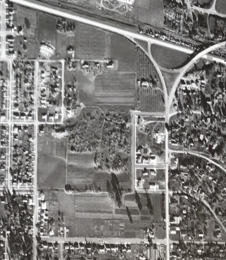
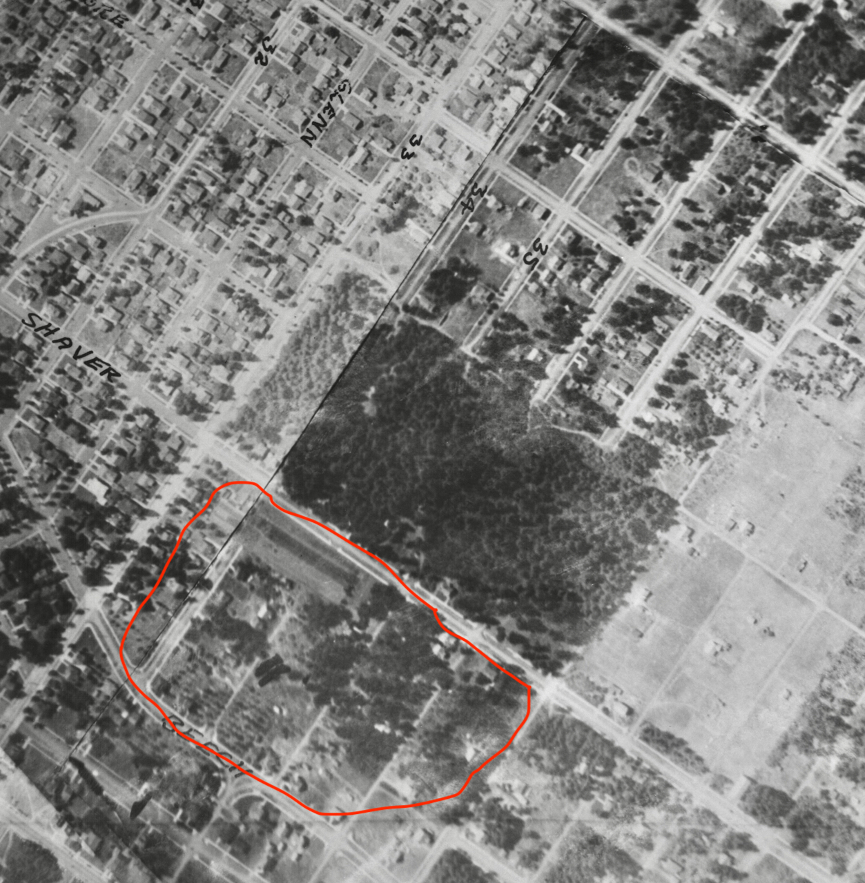
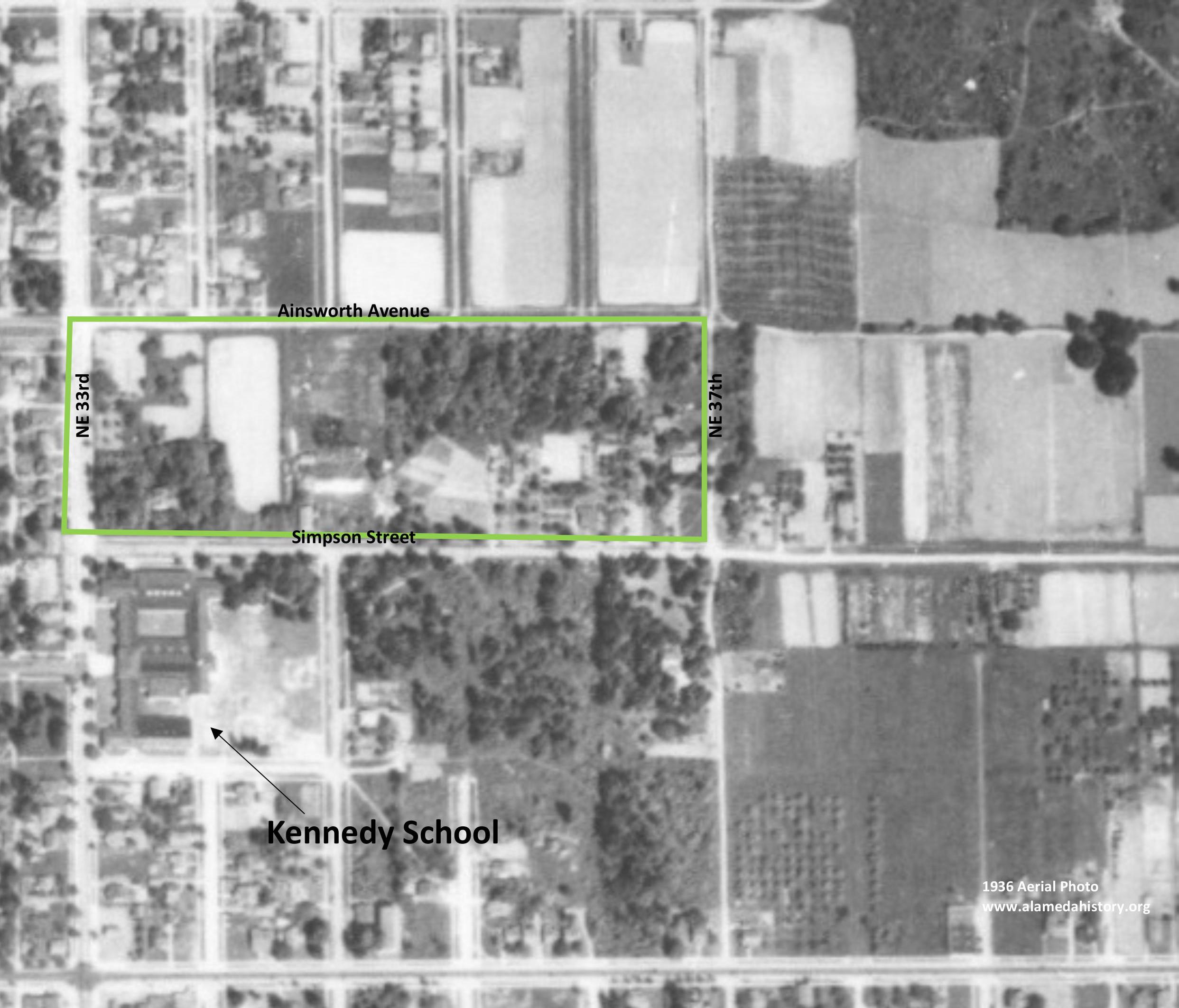
This detail of an aerial photo from 1940 shows the area of today’s Fernhill Park in the middle surrounded by farm fields on all sides. NE 42nd Avenue is the north-south street on the far right and doesn’t yet go through to Columbia Boulevard (it bends around the corner to the right where Holman is today). The north-south street on the left (that also doesn’t go through) is NE 37th Avenue. The east-west dirt road at the top of the park became today’s Holman Street. Paths, a road and a dump area are visible in the top center of the brush patch. Mike Brink’s grandparents’ home is in the upper right corner with the rows of trees and barn to the south. Photo courtesy of the University of Oregon Map and Aerial Photography Library.

It wasn’t an official dump, but more like a secluded out-of-the-way place where folks from the surrounding area knew they could get away with off-loading a truckful of junk if they needed to. So they did. In the late 1930s and early 1940s, when the NE 42nd Avenue connection to Columbia Boulevard was built, some of the dirt fill needed to make the grade change for the overpass was dug out from and supplied by the gully on the east side of the park along today’s NE 41st Avenue.

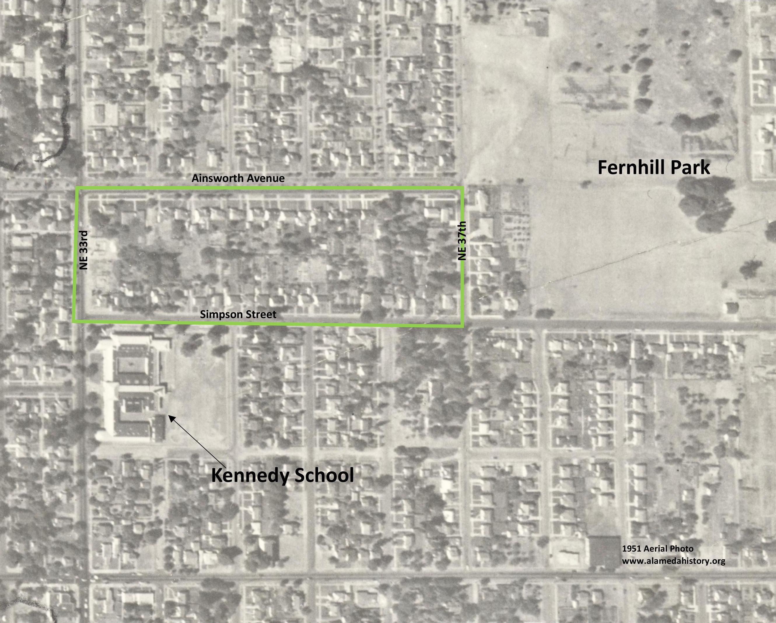
Prior to 1940, when NE 42nd didn’t go through to Columbia Boulevard, you could stand near the northeast corner of what is today’s park and see the Kennedy School across the fields and orchards stretching west to NE 33rd Avenue, with more open fields south to Killingsworth and north to the banks of the Columbia Slough. Then during the building boom of the 1940s and 50s, subdivisions marched east transforming the fields into neighborhoods.

Just 10 years later in 1950 the neighborhood was filling in. NE 42nd now goes through to Columbia Boulevard (look for the Tourist Cabins and the Spur Tavern…they’re there). NE 41st has been built and house construction is underway.  And Mike Brink’s grandparents have planted an orchard with orderly rows of filberts south of the house and bing cherries north of the house. Photo courtesy City of Portland Archives.

Often referred to as “truck farms” because the produce was trucked to market (and some of it was sold out of the back of trucks at busy intersections and small markets around town), these surrounding fields produced fruit and vegetables for Portland households. One farm near the corner of what is today’s NE 41st and Holman was owned and run by a Japanese immigrant family, as were others in the area. During WWII, Japanese farming families across the Pacific Northwest were removed from their land and placed in internment camps in southeast Oregon and central California.

We know from our recent visits with Mike Brink—who grew up in the 1940s and 50s in the tourist cabins at NE 42nd and Holman now about to be demolished—that the fields and orchards stretching out in all directions were filled with filberts, apricots, bing cherries, raspberries, strawberries and other crops. Mike remembers walking through them and through the heavily wooded thicket that is today’s Fernhill Park on his way to and from St. Andrew’s School at NE 9th and Alberta. He’d leave the cabins in the morning, pass by his grandparents farmhouse that stood near today’s intersection of NE 41st and Highland, then take the path through the woods and fields over to Ainsworth Street where he’d walk to the corner of NE 30th and Ainsworth, which was the end of the line for the Alberta Streetcar (you should check out this link because it shows the streetcar waiting where Mike used to catch it at NE 30th and Ainsworth). Hopping on a mostly empty streetcar, he’d ride south on 30th and then west on Alberta to school, reversing the process in the afternoon, maybe stopping at a neighbor’s house for hot chocolate on the way home. Quite a solo daily adventure for an elementary school kid, but times were different.

Mike doesn’t remember it being talked about in his house during those years, but gradually, the city was buying up parcels of the woods when bond money was available and when the locals were willing to sell. A couple more parcels in 1942 and 1943. Six in 1949.

As the park took shape through the late 1940s and early 1950s, some locals referred to it as Ainsworth Park, a name that appears frequently in real estate advertising of that era. By the early 1950s, most of the open land Mike remembers to the north of the park had been converted to subdivision (the Vanlaeken and Leitritz additions for readers keeping track of plat names). NE Highland Street was put through the middle of his family’s farm and his grandparents moved to a new house in the neighborhood as the working farm landscape they once knew was transformed into suburbia. By June of 1951 when most of the park buying was done, the city had invested $60,479 and had acquired 25.95 acres.

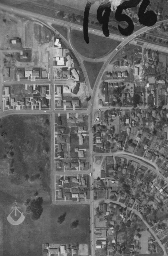
In this detail of a 1956 aerial photo, the family farm is gone replaced by the cul de sac that is today’s Highland Street and homes are under construction; all of the lots are built up between NE 41st and 42nd in the middle of the photo; a baseball diamond has arrived in the middle of it all; the paths, road and dump are gone. Once again, the Tourist Cabins and the Spur Tavern stand out clearly just right of center toward the top. Photo courtesy of the University of Oregon Map and Aerial Photography Library.

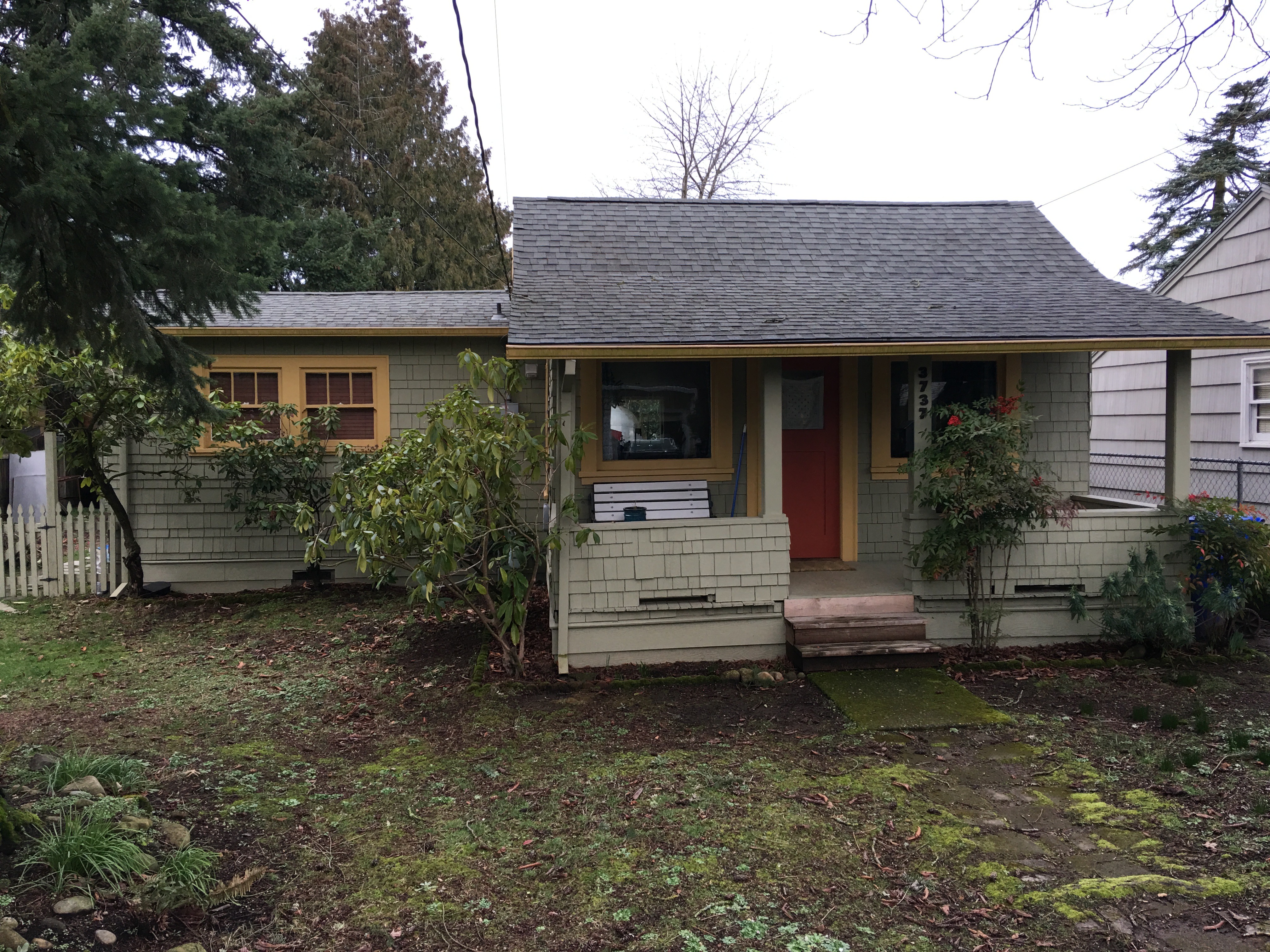
Contemporary view from a hill on the north side of the park, looking off into the Vanlaeken and Leitritz additions. Mike’s grandparents’ farm was off to the right.

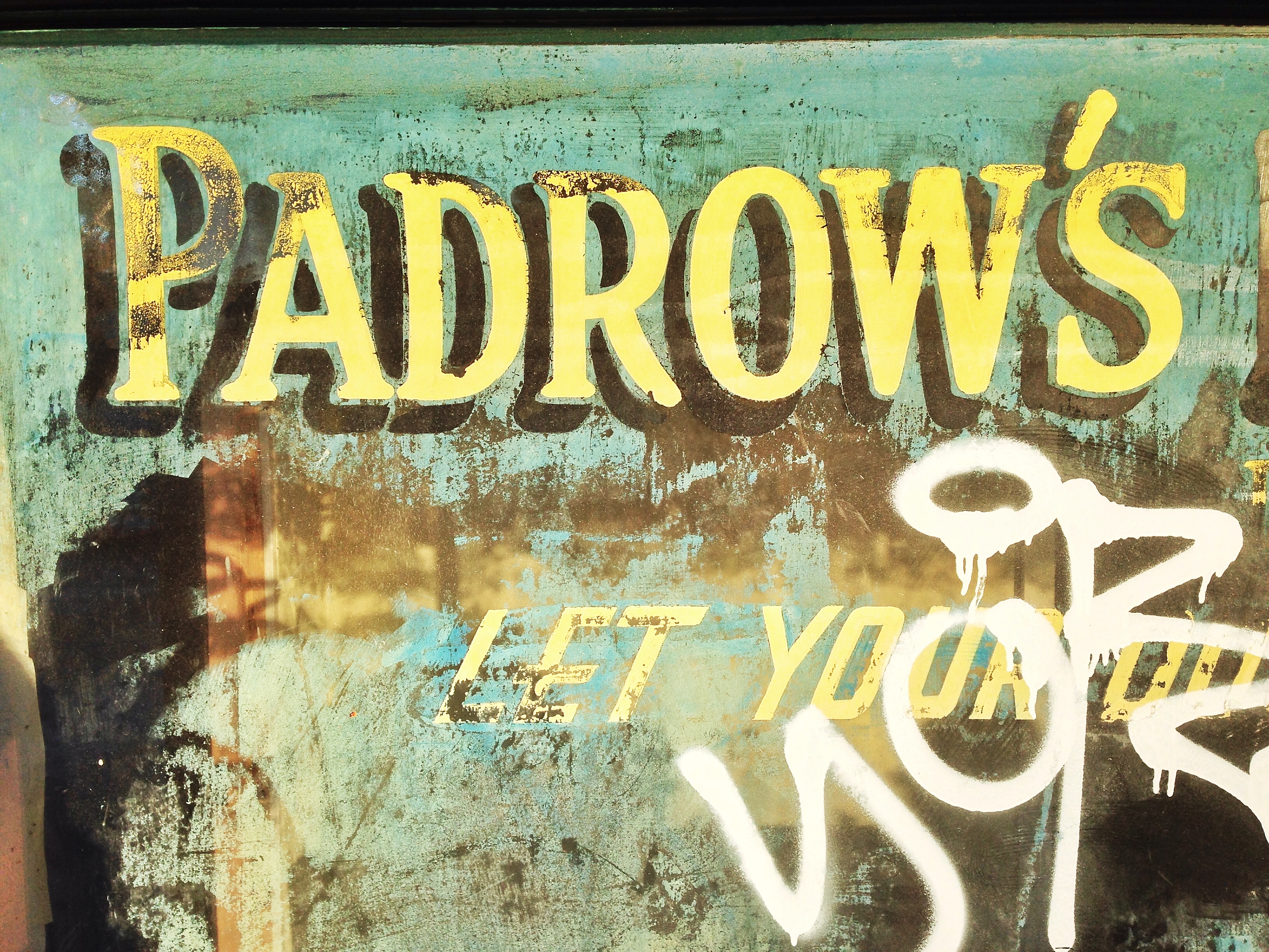
On July 14, 1954, City Council passed an ordinance officially naming the area Fernhill Park, a name that was not in local usage prior, but that probably takes its meaning from the hills on the north side of the park.

Construction of Adams High School just southeast of Fernhill Park in the mid-1960s caused quite a stir and protest from the neighborhood. Hundreds of angry neighbors turned out at a series of Portland School Board meetings in September 1964 to share their disbelief that the School Board would demolish 26 homes, three duplexes, a local greenhouse/nursery known as Knapps and a PGE substation to make room for the school. The emotion and sense of loss in the letters and petitions submitted to the school board make for tough reading. Despite this strenuous protest, demolition of the homes and businesses went ahead, construction followed, and John Adams High School opened in September 1969.

From The Oregonian, September 3, 1964. The homes and businesses inside the dotted line were demolished to make room for Adams High School.

A dozen years later, when high school enrollment dropped in the early 1980s, the building was repurposed as a middle school and operated for another 18 years before being closed in 2000 due to health concerns about mold. The building sat empty and was frequently vandalized until being torn down in 2006 leaving the large open space south of the track. Newcomers to the area today might not even know that vacant piece of ground south of the track was once a school, and before that a neighborhood, and before that farm fields, and before that an Oregon Trail-era homestead.

No history of the area would be complete without taking it back to the earliest record, when this property was homesteaded under the 1850 Donation Land Claim Act, which Congress passed to encourage settlement of the Oregon country. Isaac and Mary Rennison came across the Oregon Trail in 1852 and settled on and farmed the property, filing their Donation Land Claim in 1855 that encompasses the area bounded today by NE 33rd and NE 60th, Holman and Killingsworth.

Before all this recorded history, let’s not forget that these lands on the south shore of the Columbia River and the Columbia Slough were frequented by the Native Americans who called this area home for more than 500 generations.

Interesting, isn’t it, how the places we know and care about today as our local parks came to us partly because of unpredictable events or circumstances: Alberta Park was a brush patch owned by a Chinese immigrant who didn’t want to sell, or to control the brush and trees while the neighborhood developed around it, so the city condemned the property out from underneath him and turned it into a park. Wilshire Park was tied up in a complex probate process inadvertently delaying development until the city took out a bank loan to buy the property on the eve of its being turned into a subdivision. And much of Fernhill Park was property no one really wanted anyway because it wasn’t good cropland. Today, we take these places for granted as fixtures of neighborhood life.

With these lessons of history in mind, what should we be thinking about and taking action on today that would change some future outcome about how our neighborhood feels and operates in the future? Demolition and densification? Traffic? Hmm. More on that next week.

Memory Map: Inside the Grant Park Market

Recent photos of the Grant Park Market have conjured up memories for AH readers who recall the screen doors, the corner entry, the friendly help behind the counter, the dependable cold Coke when walking home from Grant High School. One of our frequent correspondents and Alameda export Brian Rooney sends us this memory map of the store (click to enlarge), that may bring back a memory or two for readers.

Screen Shot 2015-01-20 at 7.32.01 PM

Other memories or insights to share about the Grant Park Market and Grocery?

We like memory maps. You can find another one here, that touches on the story of Wilshire Park, both the first part and the rest of the story.

Help Renovate the Padrow Window at Wilshire Market

IMG_3689

The old Padrow Pharmacy window at the former Wilshire Market has sparked plenty of conversation in recent weeks. We were visiting the building this week when one driver pulled to the curb to ask when the new pharmacy would be opening. Ahem, well, it’s been a few years…

AH readers and neighbors who have been following will know the pharmacy window was accidentally revealed a couple years back when the former market owners were doing some remodeling and exposed it under the siding. It was definitely a novelty, and they framed it out and let it be seen again as a kind of a community service, and out of respect for the past.

The window itself is a time traveler, and has known better days. It’s actually two panes of glass, joined in the center by a steel joint. The paint is badly faded and in some cases unreadable.

IMG_3675

A detail of the window showing the chalky, fading, peeling paint. The original paint was applied to the exterior of the window and hasn’t worn well over time.


IMG_3462

The window was tagged by a vandal in October.

Along the bottom of the glass, the ad seems to suggest hand-packed ice cream may have been sold by the pint, or possibly the quart. With a little imagination, you can fill in the blanks and guess that Padrow’s also sold cosmetics along with the cigars (by the box), sundries, and box candy. No question they sold Coca-Cola, that much is front-and-center in red paint. In fact, according to second-generation sign expert Brad Ellsworth, Coca Cola probably paid for the painted window advertisement.

Part of the reason the window is in such tough shape is that it’s painted on the exterior, exposed to all the elements. Over the years, the paint has flaked off and dried, lost its pigment, and is little more than a chalky substance on the exposed surface of the glass. It won’t last long.

Fast forward to the new owner, Jeff Smalley, who for the last six months has been transforming the former 1923 commercial building into the new Fire and Stone restaurant and bakery. Jeff is a local guy, operates out of a respect for history and for the neighborhood, and wants to do something to tip his hat to the past. He’s made sure other cool windows, discovered long buried inside the market’s walls, will have visible and prominent locations inside the restaurant. And he’s been wondering what to do with the Padrow window. We’ve been talking about it, and we’ve brought in some local sign expertise to consider the options.

And then, on an evening a couple weeks back, someone spray painted graffiti on the window. Because the new tag was painted directly over the crumbling old paint, that almost ended the discussion about trying to restore the window. Focused on all the other details of getting the business up and running, Jeff was ready to just pull it out and forget about trying to do something nice.

But that’s where we came in, and after the AH post about the tagging, we heard from several readers who offered to make a donation to help bring the window back from the brink.

Enter Brad Ellsworth of North Pacific Sign and Design. Brad and his brother Curt took the company over from their dad who started his sign business about the time the Padrows opened the pharmacy (early 1950s…the pharmacy was actually a stand-alone business that had its own address even though it was in the same building as Wilshire Market). Brad and Curt grew up in the neighborhood, sent their kids through Alameda and Beaumont, and have a relative who worked at the Wilshire Market in the 1970s. Brad even has a hunch who painted the original window way back when. Let’s just say they’re invested in trying to figure this out.

IMG_3674

Brad Ellsworth (left) and Jeff Smalley examine the Padrow Window.

So after having a good look at the window and considering the possibilities, here’s the plan:

Jeff wants to keep the Padrow reference even though the window is not long for this world. So Brad is working from the original design and will create as faithful a replica as possible on the same glass, painted on the inside this time to keep it safe from the weather. Jeff’s going to talk to Coca-Cola and see if they might be willing to help with the cost. And AH readers are invited to make a donation pledge if they’d like to help (just drop me a note and I’ll get in touch with you). Brad estimates the job is probably in the $1,800-$2,000 range. Once most of the funds are in hand, we’ll ask Brad to start work. He’ll actually do the work on site, starting with cleaning and preparing the existing glass and then painting it all back. Should be interesting to watch.

So, here’s the challenge, readers. Want to help bring back the Padrow Window? I’m taking pledges right now (and have made my own of $100). If you are interested, drop me a note or leave a comment here and I’ll be in touch.

History Walk | Alameda Park Perimeter

These fall evenings are great for a brisk walk. Leaves everywhere, woodsmoke in the air, raindrops. And local history ripe for the imagination.

Alameda Park Plat Map, c. 1912

Click on the map for a larger file you can print

The northwest corner of “The Park” (as in the Alameda Park subdivision) is a little confusing, particularly around Crane Street, which has been significantly changed over time (and is actually part of the Vernon plat). Rather than trying to follow the zig-zag of the property boundary, I just walked Prescott to NE 20th to the shadow of the big water tower. Then south to Alameda Drive and around the corner to 21st, then west on Ridgewood to 20th, and then left down the hill. When you are on 20th above the ridge, from Prescott to Alameda, you can see the difference in the neighborhood plats, with Sabin to the west on one side of the street with smaller homes on smaller lots.

Turning left (east) on Fremont, you have the long straight south edge of The Park to walk, passing by where the streetcar ran up 24th and the busy commercial hub that included the Alameda Pharmacy, the old Safeway (now the bank) and what used to be two gas stations. I think of the northeast and northwest corners of NE 24th and Fremont as the gateway to The Park because that’s where the streetcar ran, and because of the business district here.

Next, you pass east by the school, built in 1921 after much lobbying by the locals and a few protests that the construction contract was awarded through some favoritism (future blog post, stay tuned). The plats off to your right are Waynewood, the Town of Wayne and Edgemont, names long forgotten.

Tip your hat to the Pearson Pine, the big old ponderosa pine tree on the southeast corner of NE 29th and Fremont. It’s been there since at least 1885.

Up the hill you go. As you pass the staircases that head up to the top of the ridge, keep in mind there are old water mains under those steps, placed when they were built in the teens. At one point, maybe in the 1920s and early 1930s, women from the Alameda Tuesday Club acted as ushers for young children passing up and down these stairs on their way to and from school.

The crest of the hill at Fremont and 33rd is Gravelly Hill, which was both a gravel pit and garbage dump for many years. The dump was under the southwest corner, where a fine house sits today.

As you walk north on 33rd, think about the 33rd street woods (today’s Wilshire Park), originally part of the Kamm Estate, which was a dense forest that played a large part in the memories of youngsters who grew up there in the 1930s and 1940s. While you’re enjoying the evening, you can also tip your hat to the home guard, made up of Alameda dads, who patrolled the neighborhood at night during the World War II years, enforcing blackout rules and making sure families kept blankets and light dampers up on their windows.

And then there are the thousands of stories that rise up from the generations who have lived in the homes you’ll pass. Lots to wonder about as you and the dog push on around the corner at Prescott and head into the home stretch (being sure to have a look up the alleys north of Prescott as you scope your next walk). So nice to be out on a history walk on a brisk November night.

Next: Walking the route of the Broadway Streetcar.

Searching for the 1920s Alameda woodcutter

A few years back, about this time of the year, we found a story in The Oregonian from the fall of 1921 that caught our attention. It was about a so-called hermit, a woodcutter who had lived much of his life in a one-room shack near Bryce Street, before Bryce was even a street and before the neighborhoods were built.

The newspaper story was trying to be one of novelty, but underneath it was actually a story of displacement. O’Donaghue was being moved on from the shack in the woods where he lived because land was being cleared and houses built.

Joseph Albert O’Donaghue told of helping clear forests to make the roads we know today, and of wolves and bears he’d killed right here on Alameda Ridge.

Some of it sounded a little fantastical. Like his memories of being a rifleman in the Crimean war 70 years earlier. Of being at least 90 years old. Of walking from Portland to San Francisco and back again.

But a bunch of it had a ring of truth and carried enough information that 100 years later, we could do a little diligence on his stories.

So before we apply some research tools to Mr. O’Donaghue’s story, read the piece below that ran in The Oregonian back on September 18, 1921. And if you want to get in the right frame of mind, you might also read our post Time Passes In Alameda from December 30, 2010, reminding us of so many layers of history here in these neighborhoods.

A careful read of the 1921 story helps us identify certain things to fuel our inquiry:

  • Researchers like a name like Joseph Albert O’Donaghue. Distinctive and traceable.
  • He was from Pictou, Nova Scotia, Canada.
  • He worked for Bernard Brandenburg, and his Bryce Street shack was on property Brandenburg owned.
  • He knew P.O. Collier (who offered him a new place to live).
  • He was a Mason.
  • He was a firewood cutter.
  • He had family in San Francisco.
  • He was a reader.

That’s enough to get us going. Here’s what we found:

The 1910 federal census shows O’Donaghue at age 67, single, living as a “hired man” with two other boarders and a cook in an unaddressed building near 37th and Fremont. It lists his birth year as 1843, from Canada, his father from Ireland, mother from Scotland, and that he arrived in the US in 1878. He reported himself as working full time as a farm laborer. We couldn’t find him in the 1920 census.

The annual Polk city directories track O’Donaghue’s presence like this:

  • 1888 listed as a laborer, boarding somewhere in East Portland (that was us before we became part of Portland proper in 1891).
  • 1906 listed as a laborer, boarding near Fremont and 36th.
  • 1916-1917 listed as a laborer, living near NE 35th and The Alameda.
  • 1921 still working as a laborer, living near NE 35th and Fremont.

His trail goes cold after the 1921 newspaper story, no city directory listings. Nothing. Then in March 1927, a death notice in Esson, British Columbia for Joseph A. O’Donaghue, age 80. Is this our man? Hard to know.

So to the next question: where was O’Donaghue’s shack? We know the property where he lived was owned by Bernard Brandenburg, who owned quite a few lots in the Spring Valley Addition, east of NE 33rd.

Spring Valley is one of the oldest plats in the area, filed on November 6, 1882 by “Clara L. Files, Spinster,” and encompassing the area east-west between 33rd and 37th and north-south between Skidmore and Bryce, including today’s Wilshire Park.

Brandenburg owned six lots which today make up the north end of the two blocks just south of Shaver between NE 33rd and 35th (when 33rd was the only road out here, the numbered streets in this vicinity didn’t exist). We’ve circled them below in red. If he lived on property Brandenburg owned, we’d guess that could be the location of O’Donaghue’s old shack.

Here’s a look at the 1925 aerial photo, with the Spring Valley Addition circled in red. Was the shack somewhere out there?

1925 aerial photo over the Spring Valley Addition. Bryce is incorrectly labeled as Beech. The dense stand of trees is today’s Wilshire Park. Aerial photo courtesy of City of Portland Archives.

Perry O. Collier was a popular and successful local real estate salesman who worked these properties as they came on the market. He may have been the one who handled the Spring Valley property deal with John L. Hartman, the big-time Portland attorney-banker-developer behind Rose City Park and other major subdivisions. Hartman bought the Spring Valley Addition property and replatted it for subdivision in June 1921. Those plans are probably what was leading to O’Donaghue’s ouster in September 1921.

This is where the story might bump into something we already know.

Not long after starting the blog—way back in 2007—we met three of the “boys” who grew up in this part of the neighborhood in the 1930s and 1940s. As often happens, our conversations led to questions, maps in hand, that would help turn back the clock. The boys told us about an old man who lived in this area, and we wrote about it in the post Memory Fragments | An old man and his dog, and a follow-up post Memory Map, which featured handwritten notes made on an old Sanborn map from one of the boys—Dick Taylor—about that exact property…that it was owned by the old man’s family. Hmm.

Is this our man? We’ll never know.

But the trip back in time is enough to reset our mental picture of the neighborhood we think we know today, and to feed our imagination. Think about that the next time you’re out on an evening stroll up Bryce on a cold night at the end of the year.

Of Special Memories and Orchard Houses

We’ve been fortunate recently to spend some time with Jeanne Allen, a 98-year-old neighbor whose sharp and clear memory reaches well back into her childhood days here in the neighborhood. Jeanne has shared her memories about everything from the old St. Charles Church at NE 33rd and Webster Street, to exploring the brushy trails in the vacant lot at 24th and Fremont where Alameda Dental is now, to earning her girl scout campfire badge in the wilds of the 33rd Street Woods (today’s Wilshire Park, which is way more tame now than the wilderness it used to be).

One of our favorite images from her memory is the nighttime landscape from the darkened second floor room of a house where she grew up on NE 24th Avenue. At night, Jeanne recalls the Broadway Streetcar making its way north, the electrical pick-up mechanism skating along the overhead wires powering the streetcar’s forward motion. As it passed her house, electrical sparks off the wires just outside the window made a dance of shadow and light inside her bedroom, searing into her memory, vivid a lifetime later.

As we talked about change during a recent drive through the neighborhood, Jeanne told us about just how different things were around here in the early years. Pointing out a small home toward the back of one lot, she said something that caught our attention:

“I sure hate to see the orchard houses going away.”

Wait. What’s an orchard house? We’ve never heard that term. We want to know more.

When Jeanne and her husband Bob built their home in Concordia back in 1950, they were surrounded by orchards of cherries, apricots, pears and apples, planted in the early 1900s. 42nd Avenue—like its parallel twin to the west 33rd Avenue—was simply known as the “County Road” and doubled as Portland city limits. Most of the streets in the surrounding area between Prescott, Killingsworth, 42nd and 33rd weren’t paved. Some hadn’t even been constructed.

Jeanne remembers simple small buildings (she didn’t call them shacks, but that’s a term that comes to mind) scattered out among the orchards that served as temporary quarters for those tending the orchards during the year and harvesting during the fall. She and her family always called these little places “orchard houses,” which was a commonly known term and function during those years.

Orchard houses took a simple form: shed-roofed front and back porch; entry door in the middle and a backdoor lined up out the back; a bedroom and window on one side, an open living space on the other, maybe a counter for food preparation; often oriented in an unusual way on the lot, either toward the back or sitting at an angle.

Here’s one that Jeanne knows for certain was an orchard house (she remembers the actual nearby orchard). Plumbing was added to the house in 1924; it was described then as an old one-story frame residence.

An orchard house, seen on a walk through the neighborhood. The rear addition was added in later years. This home has been thoughtfully updated and maintained.

Jeanne’s description got us thinking about houses we’ve seen in the neighborhood, and about evidence of orchard houses appearing in old aerial photos we’ve been looking at, and in 1928 Sanborn maps of the area. Here, take a look at these two Sanborn plates (click for a larger view).


Do you know of any orchard houses? There are likely just a small handful left and we’d like to document them and explore their stories. If you have one in mind (or think you know a candidate), send us a photo or address and we’ll see what we can learn.

Thanks Jeanne!

Figuring out the Ainsworth long block

While walking in the neighborhood—the best way to observe history in action—we’ve wondered about the very long block between Ainsworth and Simpson, bounded by NE 33rd and NE 37th. Maybe you’ve wondered too: the north-south streets of 34th, 35th and 36th don’t go through, leaving unusually deep and narrow lots. These kinds of things—like the strange zig-zag on Prescott we call the Prescott Street Jog—make us ask: What’s the story behind that?

Here, take a look. It’s the block just west of Fernhill Park:

That’s one long block. A Google image looking northwest at the long block (outlined in green). Note that none of the numbered cross streets, from 33rd to 37th, cross this long block. How come?

The long, narrow configuration of this block stems from decisions made more than 100 years ago by John D. Kennedy, the man who once owned much of the property between Killingsworth, Ainsworth, NE 33rd and NE 42nd, and for whom Kennedy School was named.

We met John D. Kennedy in our recent post about his 1929 zone change petition to turn nearby residential land at 33rd and Killingsworth into commercial property.

Born in County Limerick, Ireland in 1852, Kennedy immigrated to Oregon in 1866, finding his way to Baker City where he worked in and then owned a dry goods store. After coming to Portland about 1881, Kennedy bought this property—then outside the city limits and far from anything that even looked like development—which was originally part of the 1855 Isaac Rennison Donation Land Claim.

John D. Kennedy, about 1920. Photo originally from the Ryerson Collection, borrowed here from McMenamin’s Kennedy School.

Kennedy was an early-in speculator, perhaps 15 years ahead of his time and the market. Northeast Portland’s ripeness for real estate didn’t really take place until the years after the 1905 Lewis and Clark Exposition when it seemed anyone who could was buying property or building houses.

But Kennedy had platted these lands as the Kennedy Addition back in 1890, a grid of 15 square blocks with more than 200 lots. Here’s his original plat:


Kennedy Addition plat filed with the Multnomah County Surveyor’s Office, 1890. The grid survived, even if the street names didn’t. Translation: County Road = NE 33rd; Cleveland Street = NE 34th; Harrison Street = NE 35th; Morton Street (which was built as Marguerite Avenue)= NE 35th Place; Thurman Street = NE 36th; Blaine Street = NE 37th Avenue; Cypress Avenue = Jessup Street; Myrtle Avenue = Simpson Street. Barkholtz was an inholding property owner who wasn’t Kennedy but who went along with the plat. Interesting to note that in later years, that is the one area of the long block where a cul de sac was built.

Two years later in 1892, he platted Kennedy’s Second Addition, adjacent to the east, with more street names that didn’t make it to today (Morrow, Gilliam, Hughes and Francis). His Second Addition contained plans for another 120 homes. Speculators filed several other nearby plats about that time, including Foxchase, Irvington Park, the Willamette Addition and Railroad Heights, but they were also just lines on paper. There was no market yet for residential development.

In 1906, Kennedy filed a petition with the city to “vacate” five of the blocks in his addition. The process of vacation officially eliminates platted streets (even if they don’t yet exist), and the 1906 action—approved by City Council in ordinances 15761 and 15762—essentially erased all of the north-south streets (then called Cleveland, Harrison, Morton, Thurman and Blaine, see above) in the block between Ainsworth and Simpson, from 33rd east to 37th.


From The Oregonian, May 10, 1906

Kennedy’s stated rationale was to sell the larger chunk of land as acreage for farm fields, which is what surrounded his property at the time. It seems he was eager to sell the property and was essentially repackaging it for what was at that moment the most active part of the market (even though Northeast Portland was on the cusp of a homebuilding explosion). Not long after the City Council action, Kennedy did just that:

Classified advertisement for the vacated property, from The Oregonian, October 21, 1906

In the years that followed as urbanization spread, neighborhoods were built to the north, south and west, and Kennedy’s smart and early real estate speculation paid off. But the 12-acre parcel, with no north-south through streets due to his 1906 decision to vacate streets from the property, stayed as one big block in farm use.

After Portland voters passed a $500,000 park acquisition bond measure in 1919, Kennedy courted the city with the long block tract—a perfect park size at 12 acres—suggesting it would make a great place for playgrounds, picnic tables and ball diamonds. This was long before Fernhill Park or Wilshire Park (which have their own interesting stories well worth reading), and concurrent with consideration of Alberta Park, which was ultimately selected over Kennedy’s tract for purchase and development. Think about that: what if today’s Alberta Park had become neighborhood streets as planned, and Kennedy’s long block was a park? Hmm.

Here’s an aerial photo of the area from 1936 that shows the long block with a few homes, the oldest dating back to 1909…purchased from Kennedy after the 1906 ordinance passed creating the 12-acre parcel. One home, on the Simpson Street side, actually pre-dates Kennedy’s 1890 plat.

Detail of 1936 aerial photo. Courtesy of University of Oregon Map & Aerial Photography Library.

Kennedy died in December 1936. In 1938, the property was controlled by Ward D. Cook, a Portland insurance and real estate agent, who designated 80 lots on the long block ready for construction. It wasn’t until after World War II when the market truly picked up, and most of the houses were built and sold between 1940 and 1950. Here’s a glimpse from 1951 that shows the property fully built out:

Detail of 1951 aerial photo. Courtesy of City of Portland Archives.

So there you have it: In the original Kennedy’s Addition plat, that one long block was going to be five blocks. But then Kennedy did away with the blocks to better sell the property. The market came and went and came back again. Then another speculator saw opportunity and turned the island of farm into the more than 50 lots there today, most of them a very long and narrow quarter-acre each.

Gravel & Garbage: A history of NE 33rd and Fremont

Over the years, we’ve heard the notion that there was once a gravel pit and then a garbage dump at the corner of NE 33rd and Fremont. We remember in the 1990s when the house at the southwest corner—the one with the old swimming pool out back—was removed because of major foundation problems, which seems like reasonable evidence of the underlying problem.

But we wanted to know more, so we tracked down the details. Let’s start with a photo to put you in context.

Here is the area in a 1925 aerial photo, the earliest one we know of. There’s lots to look at here, but start at the large vacant lot in the lower right hand corner. The street running east-west is Fremont and the vacant lot just below it to the south is actually three blocks, between today’s NE 32nd Avenue on the left and “E 33rd” on the right. 32nd Place (then known as Glenn Avenue before the Great Renumbering) does not yet go through.

Detail from a 1925 aerial photo showing the intersection of Fremont and 33rd, two labels added for reference. Click to enlarge. Aerial photo courtesy of City of Portland Archives.

That’s a pretty steep slope to the south (just ask local kids with sleds hoping for snowfall) which is one reason it’s one of the few unbuilt pieces of ground you can see in this photo.

Back in the late 1890s and up until about 1910, that slope was heavily excavated for gravel, which makes sense. It’s right along the crest of the Alameda Ridge, which after all is one giant gravel deposit left over from the cataclysmic Lake Missoula Floods of 13,000-15,000 years ago. The Fremont gravel pit provided tons of rock for a young and growing Portland, which was busy building roads. In those early years, 33rd and Fremont even became known as Gravelly Hill, a name that stuck around for decades (we try to slip that name into a conversation whenever we can, you should try it just to keep it alive).

In the photo, you can see the disturbed area at the top of the slope all along the southern edge of Fremont. That was the top of the gravel pit. A few years later it was also the top of the garbage dump.

In 1910, Benjamin Lombard, who developed the Olmsted Park plat which you can see just up the hill in this photo (now considered part of the Alameda neighborhood), sued the city for violating its own ordinance that prohibited gravel pits within 100 feet of a public street. Fremont was a city-owned street, plus the city owned a good chunk (but not all) of that vacant lot to the south too. East 33rd had long been known simply as the County Road and was the county’s responsibility.

A letter to county commissioners in August 1910 reported “the roadway at Thirty-third and Fremont streets is in danger of caving in because of excavation in the Fremont gravel pit.” The county passed this complaint along to the city, which was also hearing from Lombard about the same time. Due to the undercutting of the slope required by the gravel mining operations, Fremont Street was just about ready to slide down the hill.

This 1910 kerfuffle ended the slope’s official function as a gravel pit, though other places—notably a nearby hollow on privately owned land at the corner of today’s NE 37th and Klickitat—stepped in to meet the gravel need.

Fast forward to the early 1920s. Portland was booming and rapidly running into a garbage disposal problem. The city’s Guilds Lake Incinerator, located in Northwest Portland at NW 25th and Nicolai, was operating at full capacity and the city needed to find another way to deal with garbage.

William G. Helber, Portland’s Superintendent of Garbage Disposal, had visited Seattle and seen a new technique called “sanitary fill,” whereby garbage was mixed with dirt and buried in layers on uneven ground. This had the double “benefit” of disposing of garbage and leveling off land that could then be used or sold for other uses.

When Helber looked out across the Portland landscape, he fixed on several locations he believed would function well as sanitary fills.


From The Oregonian, January 16, 1923

Because the city didn’t own the downslope part of the hill, it took some creative deal making with the adjacent private owner to make it all work. Downslope owners Joe and Frances Brooks also owned the gravel pit at 37th and Klickitat. They agreed to let the city use the lower end of the Fremont pit for the garbage fill as long as the city would also fill up their old gravel pit on Klickitat with garbage. This site became known as the “Beaumont Fill.” The Brooks were then free to sell that as viable real estate to the developer who wanted to build houses there.

Not everyone was happy with the idea of burying garbage so close to existing homes. Alameda neighbors, who were always ready to protest (schools, camps, churches), were particularly skeptical. But Helber took them out on the ground to have a look at what he had in mind and the neighbors seemed satisfied to give it a try.

From The Oregonian, January 20, 1923

Starting in February 1923 through June 1924, all non-commercial trash from Portland’s eastside was hauled to Alameda to fill up the old Fremont gravel pit.

From The Oregonian, February 7, 1923

When the summer of 1923 rolled around, everyone held their breath (and their noses) wondering if the heat and the garbage would create a smelly problem. No news must have been good news, because there was no further coverage.


From The Oregonian, June 6, 1923


Here’s a great photo from the early 1930s that shows both of the completed sanitary fills (and so much else to look at). We love this photo.

Aerial oblique photo from the early 1930s shows both former fill sites and a lot more, including a very brushy Wilshire Park and the new Beaumont School. Click to enlarge this amazing photo.

In 1924, one year after opening when it became time to shut down the Fremont Sanitary Fill, the city realized it had trained all of east Portland to bring its trash to Alameda, and that it would probably take some retraining and even some enforcement to break the habit.

From The Oregonian, May 30, 1924

In a final accounting contained in his January 1926 report to City Commissioner Charles A. Bigelow, Garbage Disposal Bureau Director Helber summarized the following statistics for the Fremont Street Sanitary Fill:

  • Estimated number of loads of garbage received: 1,618
  • Average number of loads received per day: 62 ½
  • Average tons of garbage dumped each day: 136
  • Estimated tons of garbage dumped: 3,541 ½
  • Average yards of dirt received per day: 3 ½
  • Total salary of all dump workers per month: $442
  • Monthly installment on new tractor used on site: $121.25

That’s a lot of garbage. Sixty-two loads arriving at the top of the hill on Fremont Street each day for more than a year, dumped over the edge, spread by tractor down the slope and covered over with a little dirt.

The city continued to use the sanitary fill method in other areas as it planned a larger incinerator—a long drawn out process because no neighborhood wanted it in their backyard—which was ultimately built in 1932 in St. Johns and is known today as Chimney Park.

But in the meantime while incinerator planning and location were being fought about in City Hall, the fill method was gaining critics. Here’s news of neighbors at NE 37th and Alberta (today’s Alberta Court) complaining about the stench to City Council.

From The Oregonian, October 20, 1927

Back at the Fremont fill in the early 1940s, home construction was just getting underway. Here’s a photo from 1943.

Detail from a 1943 aerial photo, green outline added to show former gravel pit and fill area.